171009 local scheme amendment document · 4.1. state planning 8. ... whereby this report has been...
TRANSCRIPT

Shire of Carnarvon Town Planning Scheme No. 10
Scheme Amendment No. 73Lot 324 Egan Street, Carnarvon
(Former Carnarvon Primary School)

Job Ref: 21450
V1.0.1012016
Contents
1. Introduction 1
2. Description of Amendment Area 2
2.1. Regional Location 2
2.2. Locality 2
2.3. Existing Improvements 4
2.4. Land Ownership 4
3. Site Context 5
3.1. Transport, Traffic & Access 5
3.2. Environmental 5
Flora & fauna 5
Landform & Soils 5
Contamination 6
Aboriginal Heritage 6
European Heritage 6
Bushfire Hazard 6
Carnarvon Airport. 6
3.3. Infrastructure & Services 7
4. Town Planning Considerations 8
4.1. State Planning 8

Shire of Carnarvon Town Planning Scheme No. 10
Scheme Amendment No. 73
Carnarvon Structure Plan 2004 8
Gascoyne Regional Planning & Infrastructure Framework 2015 8
4.2. Local Planning 9
Shire of Carnarvon Local Planning Strategy 2017 9
Shire of Carnarvon Strategic Community Plan 2011 9
Carnarvon Airport Precinct Structure Plan 2014 9
Shire of Carnarvon Town Planning Scheme No.10 11
5. Zoning Rationale 16
Appendices Appendix A Draft Deposited Plan 409809
Appendix B Opportunities & Constraints Plan
Appendix C Indicative Concept Plan
Appendix D Scheme Amendment Map
Appendix E Bushfire Attack Level Assessment Report – BAL Contour
RESOLUTION DECIDING TO AMEND A LOCAL PLANNING SCHEME
ADOPTION
FINAL APPROVAL CERTIFICATION PANEL
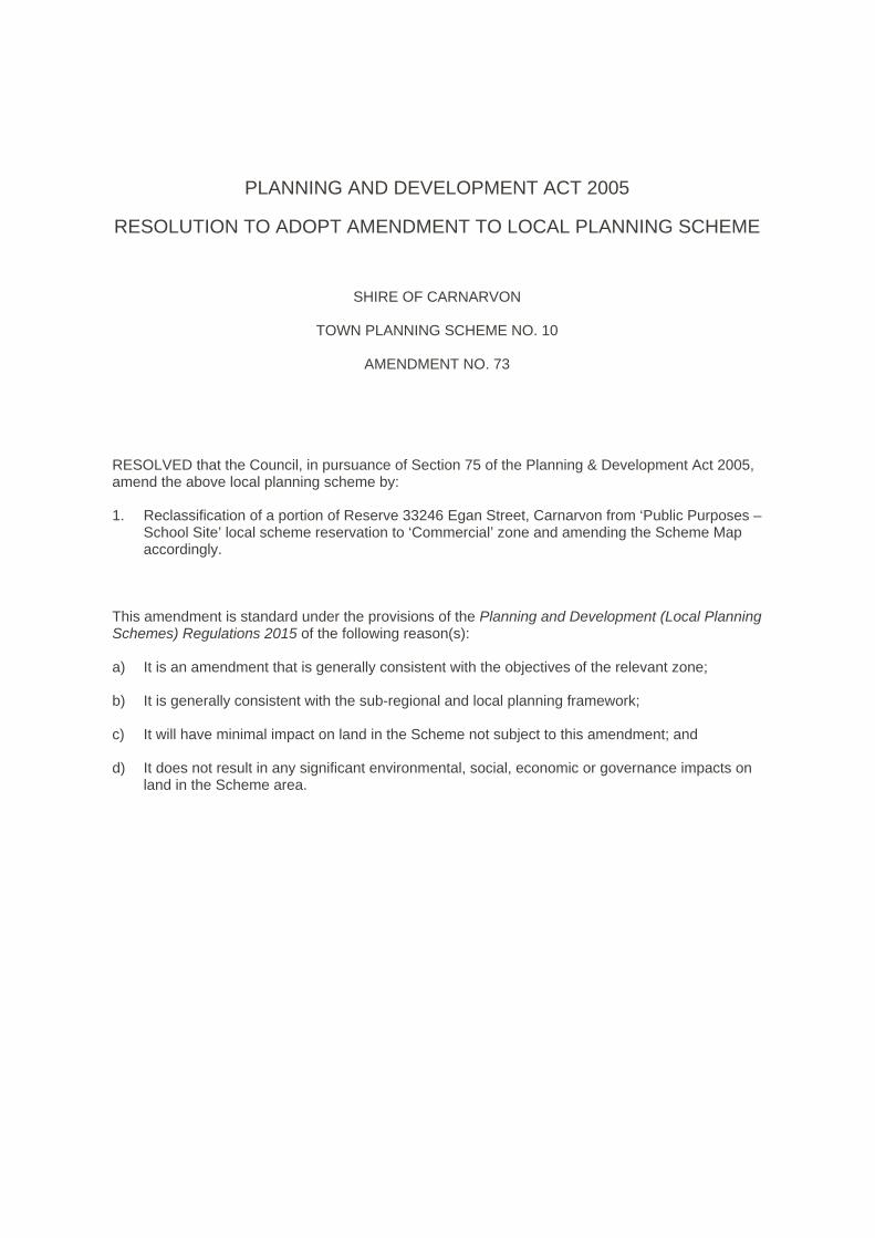
PLANNING AND DEVELOPMENT ACT 2005
RESOLUTION TO ADOPT AMENDMENT TO LOCAL PLANNING SCHEME
SHIRE OF CARNARVON
TOWN PLANNING SCHEME NO. 10
AMENDMENT NO. 73
RESOLVED that the Council, in pursuance of Section 75 of the Planning & Development Act 2005, amend the above local planning scheme by:
1. Reclassification of a portion of Reserve 33246 Egan Street, Carnarvon from ‘Public Purposes – School Site’ local scheme reservation to ‘Commercial’ zone and amending the Scheme Map accordingly.
This amendment is standard under the provisions of the Planning and Development (Local Planning Schemes) Regulations 2015 of the following reason(s):
a) It is an amendment that is generally consistent with the objectives of the relevant zone;
b) It is generally consistent with the sub-regional and local planning framework;
c) It will have minimal impact on land in the Scheme not subject to this amendment; and
d) It does not result in any significant environmental, social, economic or governance impacts on land in the Scheme area.

MINISTER FOR PLANNING
PROPOSAL TO AMEND A TOWN PLANNING SCHEME
LOCAL AUTHORITY: Shire of Carnarvon
DESCRIPTION OF TOWN PLANNING SCHEME:
Town Planning Scheme No.10
TYPE OF SCHEME: District Scheme
SERIAL NUMBER OF AMENDMENT: Amendment No. 73
PROPOSAL: To reclassify a portion of Reserve 33246 Egan Street, Carnarvon from ‘Public Purposes – School Site’ local scheme reservation to the ‘Commercial’ zone and amending the Scheme Map accordingly.

Shire of Carnarvon Town Planning Scheme No. 10
Scheme Amendment No. 73
1. Introduction Veris acts on behalf of LandCorp, whereby this report has been prepared to provide the rationale and justification to support a proposal to amend the Shire of Carnarvon Town Planning Scheme No.10 (TPS 10) from the ‘Public Purpose – School Site’ reservation to the ‘Commercial’ zone, over a portion of Lot 1322 Egan Street, Carnarvon. The relevant portion is currently being subdivided from Lot 1322 and will be known as Lot 324. As the proposed scheme amendment is applicable to this proposed lot, discussion throughout the report will be by reference to this land parcel.
Lot 324 is a redundant State Government land asset and the State Government has proposed to dispose of the site to the market through the Land Asset Sales Programme (LASP) administered by Department of Lands and LandCorp. The area of Lot 324 is approximately 1.83 hectares.
The amendment seeks to change the current ‘Public Purpose – School Site’ reservation of the subject lot by reclassifying the land to the ‘Commercial’ zone (refer to Appendix D Scheme Amendment Map). A change to the ‘Commercial’ zone will facilitate both commercial and residential development.
This report sets out the strategic planning context along with suitability and capability of the area for the rezoning.
This report includes a description of the following matters:
Site details and locational information;
Background to formulation of the amendment request;
Description of the existing land uses and site attributes;
Consideration of relevant State and local statutory planning and policy context;
Detailed explanation of the proposed Amendment; and
Justification for the proposed Amendment.

Shire of Carnarvon Town Planning Scheme No. 10
Scheme Amendment No. 73
2. Description of Amendment Area 2.1. Regional Location
The subject site is located in the Municipality of the Shire of Carnarvon and is on the periphery of the Carnarvon Town Centre opposite the Carnarvon Airport. Figure 1 shows the location of the subject site in the context of Carnarvon.
FIGURE 1 REGIONAL LOCATION. SOURCE: GOOGLE MAPS, 2017 - MODIFIED
2.2. Locality
The subject lot has frontages to Egan Street to the south west and Carnarvon Road to the east. It is generally bound by the School of the Air to the north, the Carnarvon Airport to the east, residential uses to the south, commercial land uses to the south west and a parks and recreation reserve to the north west (Figure 2 shows the general boundary of the subject land). Figure 3 shows the cadastre of the site.
Subject Site

Shire of Carnarvon Town Planning Scheme No. 10
Scheme Amendment No. 73
FIGURE 2: 2015 AERIAL OF SUBJECT LOT AND SURROUNDS. SOURCE: LANDGATE, 2017 - MODIFIED
FIGURE 3: CADASTRE PLAN. SOURCE: LANDGATE, 2017 - MODIFIED

Shire of Carnarvon Town Planning Scheme No. 10
Scheme Amendment No. 73
2.3. Existing Improvements
Lot 324 is developed with primary school buildings and associated infrastructure. The site is fenced on the north, west and southern boundaries. The subject site originally formed part of the Department of Education Carnarvon Primary School. A portion of the original primary school land, buildings and infrastructure (approximately 25%) is currently being leased to the Carnavon School of the Air as a flying school where lectures and administration are held. The remaining balance (approximately 75%) of the former primary school land, buildings and infrastructure is contained on the subject site, which is now redundant and proposed for disposal.
The existing buildings and infrastructure on Lot 324 are proposed to remain as part of the Scheme Amendment. The subject site is proposed to be disposed with the existing buildings and infrastructure. The Prospective Purchaser may either choose to re-adapt the existing buildings and infrastructure, or partially or wholly demolish to make way for redevelopment.
2.4. Land Ownership
Details of the land ownership is as follows:
TABLE 1 OWNERSHIP DETAILS
LOT NO.
ADDRESS CERTIFICATE OF TITLE
OWNER AREA (HA)
1322 39 Egan Street, Carnarvon LR3110/41 Department of Education 2.67
Lot 1322 is currently being subdivided to create Lot 324, which will be 1.833 hectares in area. A copy of the draft deposited plan is located at Appendix A.

Shire of Carnarvon Town Planning Scheme No. 10
Scheme Amendment No. 73
3. Site Context 3.1. Transport, Traffic & Access
Lot 324 currently has vehicle access from Egan Street allowing for full movement. Egan Street is under the care and control of the Shire of Carnarvon and connects to Robinson Street to the west. This road is a two-lane single carriageway Access Road with a pathway. Lot 324 also has frontage to Carnarvon Road however does not currently have a vehicle access. It is noted however that the northern portion of the primary school (being leased to Carnarvon School of the Air) has an access point to Carnarvon Road via a crossover allowing full movement. Carnarvon Road is also under the care and control of the Shire and is classified as a Regional Distributor.
The subject site has existing suitable access to the local transport network via Egan Street and also potentially Carnarvon Road with a secondary access point. Future access arrangements onto Carnarvon Rd would be subject to further investigation at the detailed subdivision/development approval stage when a formal proposal is put forward.
3.2. Environmental
FLORA & FAUNA
Lot 324 features some mature trees however is primarily cleared of vegetation as part of the development of the primary school. As there is limited vegetation it is highly unlikely that there will be any significant flora and fauna habitat within the site. As part of any future redevelopment, retention of any significant trees on-site can be further investigated. It is considered that there are no significant flora and fauna environmental constraints that would prevent redevelopment of the site.
LANDFORM & SOILS
The topography of the site is relatively flat and there are considered to be no topographical constraints to urban development of the subject site.
A desktop assessment to determine the presence of Acid Sulphate Soils (ASS) indicates that there is an unlikely possibility of ASS affecting the subject site
Further detailed geotechnical investigation would be a requirement at development and subdivision approval stage.
HYDROLOGY AND WATER MANAGEMENT
There are considered to be no hydrological constraints impacting the development of the subject site and the site is not subject to flooding as illustrated in Figure 4 below, which shows the 100 year flood mapping for the site.
In accordance with the requirements of Better Urban Water Management (WAPC, 2008) given the size of the site and it’s classification as an infill development, water management can be addressed at the subdivision or development stage.

Shire of Carnarvon Town Planning Scheme No. 10
Scheme Amendment No. 73
FIGURE 4: 100 YEAR MAP. SOURCE: INFRASTRUCTURE PLANNING & DEVELOPMENT
CONTAMINATION
Lot 324 is not listed in the DER Contaminated Sites Database. Should any of the existing primary school buildings and infrastructure be demolished and removed from site, consideration should be given to any building materials which may contain asbestos.
ABORIGINAL HERITAGE
According to the Department of Aboriginal Affairs (DAA) Aboriginal Heritage Inquiry System, Lot 324 is not affected by any registered aboriginal heritage sites.
EUROPEAN HERITAGE
A search of the State Heritage Office’s Register of Heritage Places (inherit) has confirmed that Lot 324 is not considered to be of European heritage significance.
BUSHFIRE HAZARD
Lot 324 is located in a bushfire prone area according to a search of the Department of Fire and Emergency Services (DFES) Map of Bush Fire Prone Areas. In accordance with the requirements of State Planning Policy 3.7 – Planning in Bushfire Prone Areas a Bushfire Attack Level (BAL) Assessment has been undertaken. The report on this assessment is located at Appendix E. The assessment determined that a BAL rating of LOW to 12.5 is applicable to the site. This rating does not preclude development however future buildings may need to comply with the construction standards set out in AS3959-2009.
CARNARVON AIRPORT.
The subject site is adjacent to the Carnarvon Airport however the site is not affected by Australian Noise Exposure Forecast (ANEF) contours and therefore is not impacted by excessive noise from aircraft operations. A small portion of the south east corner of the site is affected by Obstacle Limitation Surfaces (OLS), which are a series of surfaces that set the height limits of objects around an aerodrome. Objects that project through the OLS become obstacles. The objectives of the OLS

Shire of Carnarvon Town Planning Scheme No. 10
Scheme Amendment No. 73
are to define the airspace around aerodromes to be maintained free of obstacles so as to permit the intended aeroplane operations at the aerodromes to be conducted safely and to prevent the aerodromes from becoming unusable by the growth of obstacles around the aerodrome. As shown on the Opportunities & Constraints Plan (Appendix B), the height limit for the area of the site affected by the OLS is 40m.
3.3. Infrastructure & Services
Lot 324 is currently serviced by reticulated water, sewer and power infrastructure that is located within the Egan Street road reservation. Upgrades to the servicing infrastructure to support future urban development may be required in consultation with the relevant service providers based on the types of land uses and level of development intensification, which will be determined at later stages of planning.

Shire of Carnarvon Town Planning Scheme No. 10
Scheme Amendment No. 73
4. Town Planning Considerations 4.1. State Planning
CARNARVON STRUCTURE PLAN 2004
The Carnarvon Structure Plan was prepared as part of the Ningaloo Coast Regional Strategy Carnarvon to Exmouth. The structure plan identifies key land use planning objectives, actions and guidelines for the orderly development of the Carnarvon town site.
The relevant provisions of this structure plan are as follows:
The Carnarvon town centre is defined clearly by Olivia Terrace, Robinson and James streets, Carnarvon Road and Douglas, Francis and Forrest streets. It consists of flat, developed land, comprising a mix of civic, cultural/entertainment, retail/commercial, educational and recreational uses.
Opportunities for medium-density residential development within the town centre should be explored along with the potential provision for facilities to attract retirees to relocate to Carnarvon to take advantage of its climate.
The Shire has also highlighted that limited vacant commercial land exists in Carnarvon although immediate needs may be addressed through infill and intensification of existing commercial land use.
The subject site is strategically located within the Carnarvon Town Centre and offers opportunities (in the context of the Structure Plan) as follows:
- Potential vacant commercial land, subject to demolition of existing primary school buildings and infrastructure;
- Potential re-adaption of either part or all of the existing primary school buildings and infrastructure for commercial use;
- Potential vacant residential land, including aged persons accommodation, subject to demolition of existing primary school buildings and infrastructure;
- Potential opportunities for Mixed Use development in any combination of one or more of the above.
Given the relatively large scale land area of the subject site in the context of the Carnarvon Town Centre, the site presents a unique and ideal opportunity to provide prospective new development opportunities to service the town.
GASCOYNE REGIONAL PLANNING & INFRASTRUCTURE FRAMEWORK 2015
The Gascoyne Regional Planning & Infrastructure Framework was prepared by the WAPC to guide the region’s strategic planning and to integrate planning and infrastructure decisions. Opportunities identified in the framework that are relevant to the scheme amendment are as follows:
Identify sufficient and appropriately located land to accommodate growth.
Facilitating local industry and services through the provision of adequate industrial and commercial land within Gascoyne townsites.
Provide the requisite hard and social infrastructure to facilitate and support future growth of Carnarvon’s population and local economy.
The previously mentioned range of development opportunities are consistent with the objectives of the Framework.

Shire of Carnarvon Town Planning Scheme No. 10
Scheme Amendment No. 73
4.2. Local Planning
SHIRE OF CARNARVON LOCAL PLANNING STRATEGY 2017
In support of the proposed scheme amendment, the LPS identified the need to revitalise the Carnarvon Township as the primary centre with a focus on strong retail, commercial, food and beverage and entertainment uses and to ensure that land is appropriately zoned to provide opportunities for business investment over the next 10-15 years. It also identified the need to promote redevelopment of areas that can provide increased housing opportunities and housing diversity in areas close to the town centre. To implement these objectives the draft LPS identified the following actions:
Generally maintain the existing residential density coding and zoning identified under the Scheme, providing for opportunities for increased density in areas of high accessibility and amenity, such as the Fascine or areas surrounding the town centre.
Promotion of commercial and mixed use opportunities, such a cafes along Olivia Terrace and the waterfront area. Ensure that the local heritage of the Shire is preserved and enhanced during this process. Retain existing residential densities and zoning for Brockman, Morgantown & South Carnarvon.
The scheme amendment proposal is considered to comply with these LPS objectives and actions.
SHIRE OF CARNARVON STRATEGIC COMMUNITY PLAN 2011
The Strategic Community Plan outlines the Shire’s long term vision, values, aspirations and objectives, based on the input provided by the community. Some of the strategies identified in the Strategic Community Plan that are relevant to the Scheme Amendment are as follows:
Outcome 1.2 Increased availability of serviced residential, commercial and industrial land.
1.2.3 Facilitate and / or participate in the development of Shire, State Government and private sector land holdings. 1.2.4 Investigate joint ventures to develop commercial, residential and industrial properties.
The proposed ‘Commercial’ zone for the subject site can offer a diverse range of redevelopment opportunities, which are consistent with the Shire’s Community Plan.
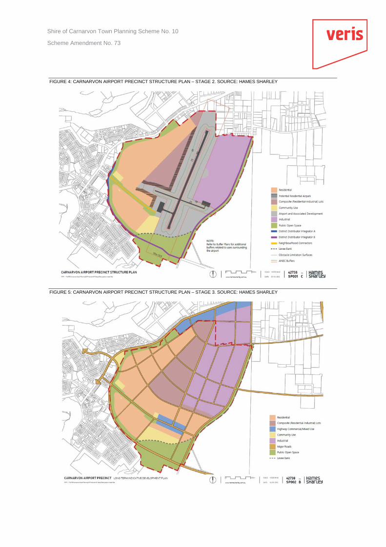
CARNARVON AIRPORT PRECINCT STRUCTURE PLAN 2014
This structure plan sets the strategic framework for future devleopment of land uses within the airport site and immediate surrounds. It has been based on a two stage implementation process and identifies a third stage, should the airport facility relocate to another site in the future, thus releasing the remaining land for development.
The first stage of the implementation of this structure plan will involve the relocation of the existing runways, whilst stage 2 proposes the establishment of residential, industrial, composite residential/industrial, community and public open space land uses around the relocated runways (Figure 5). The third stage is based on the relocation of the airport to another site and the development of the airport land with residential, industrial and commercial uses (Figure 6).
Lot 324 is located immediately adjacent to the area covered by this structure plan however none of its recommendations are considered to impact on the proposal to zone Lot 324 as commercial.
Shire of Carnarvon Town Planning Scheme No. 10
Scheme Amendment No. 73
FIGURE 4: CARNARVON AIRPORT PRECINCT STRUCTURE PLAN – STAGE 2. SOURCE: HAMES SHARLEY
FIGURE 5: CARNARVON AIRPORT PRECINCT STRUCTURE PLAN – STAGE 3. SOURCE: HAMES SHARLEY

Shire of Carnarvon Town Planning Scheme No. 10
Scheme Amendment No. 73
SHIRE OF CARNARVON TOWN PLANNING SCHEME NO.10
Under the provisions of Town Planning Scheme No.10 (TPS 10) Lot 324 is currently reserved as ‘Public Purposes – School Site’. Overleaf is an extract from TPS 10 showing the location of the subject lot (Figure 7). The proposal is to reclassify the subject land from ‘Public Purposes’ to ‘Commercial’, as shown on the proposed Town Planning Scheme Amendment Plan included in this report.
FIGURE 7: TOWN PLANNING SCHEME NO.10 MAP EXTRACT. SOURCE: DEPARTMENT OF PLANNING, 2017 - MODIFIED
It is not desirable to retain the existing public purpose reservation of the subject site, especially if the site will be disposed of on the market. Given the redundant nature of the public purpose reservation, a sequential zone is required to faciliate a compatible and logical redevelopment of the site.
The proposed ‘Commercial’ zone will compliment the existing ‘Commercial’ zone within the Carnarvon Town Centre and also provide opportunties for appropriate new development and expansion, as outlined in the Draft Shire Local Planning Strategy. A ‘Commercial’ zone for the subject site is a logical sequential zone and will not compromise or adversely impact the amenity of the existing neighbouring land uses.
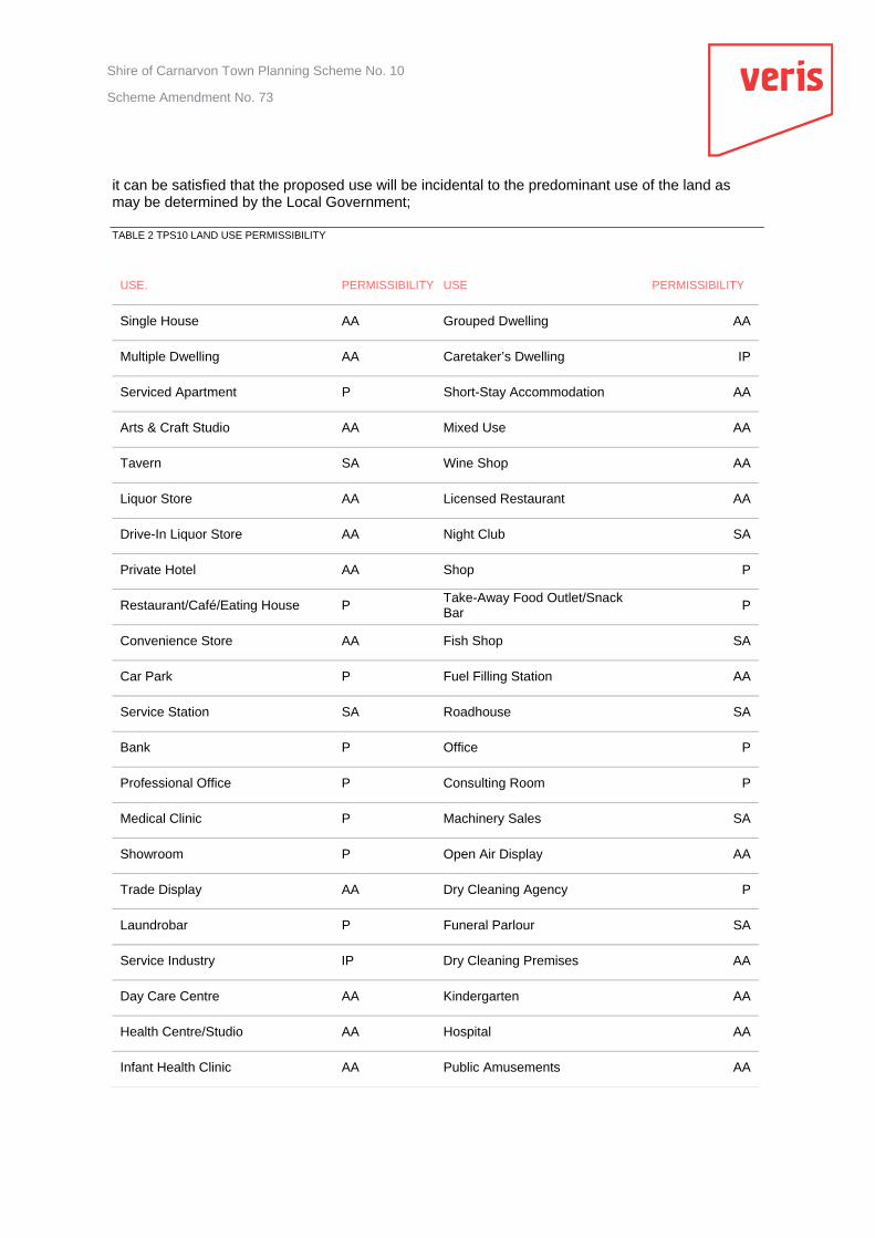
Land Use Permissiblity Under TPS10 the land use permissibility for ‘Commercial’ zoned land is outlined in Table 2 overleaf.
Note: ‘P’ means that the use is permitted provided it complies with the relevant standards and requirements laid down in the Scheme and all conditions (if any) imposed by the Local Government in granting planning consent;
‘AA’ means that the Local Government may, at its discretion, permit the use;
‘SA’ means that the Local Government may, at its discretion, permit the use after notice of application has been given in accordance with Clause 4.3;
‘IP’ uses in respect of which Planning Approval will not be granted by the Local Government unless
Shire of Carnarvon Town Planning Scheme No. 10
Scheme Amendment No. 73
it can be satisfied that the proposed use will be incidental to the predominant use of the land as may be determined by the Local Government;
TABLE 2 TPS10 LAND USE PERMISSIBILITY
USE. PERMISSIBILITY USE PERMISSIBILITY
Single House AA Grouped Dwelling AA
Multiple Dwelling AA Caretaker’s Dwelling IP
Serviced Apartment P Short-Stay Accommodation AA
Arts & Craft Studio AA Mixed Use AA
Tavern SA Wine Shop AA
Liquor Store AA Licensed Restaurant AA
Drive-In Liquor Store AA Night Club SA
Private Hotel AA Shop P
Restaurant/Café/Eating House P Take-Away Food Outlet/Snack Bar
P
Convenience Store AA Fish Shop SA
Car Park P Fuel Filling Station AA
Service Station SA Roadhouse SA
Bank P Office P
Professional Office P Consulting Room P
Medical Clinic P Machinery Sales SA
Showroom P Open Air Display AA
Trade Display AA Dry Cleaning Agency P
Laundrobar P Funeral Parlour SA
Service Industry IP Dry Cleaning Premises AA
Day Care Centre AA Kindergarten AA
Health Centre/Studio AA Hospital AA
Infant Health Clinic AA Public Amusements AA

Shire of Carnarvon Town Planning Scheme No. 10
Scheme Amendment No. 73
Place of Public Worship AA Place of Public Assembly AA
Recreation P Civic Building AA
Museum AA Public Utility P
Education Establishment AA Radio/TV Installation P
Private Club AA Veterinary Clinic SA
Development Standards
To regulate the form of development a summary of the relevant provisions are as follows:
US
ES
CA
R P
AR
KIN
G
LAN
DS
CA
PIN
G
SIT
E C
OV
ER
AG
E SETBACKS (M)
FR
ON
T
SID
E
RE
AR
Shops & Banks # 1 cps/20m2 * 100% Nil Nil Nil
Café, Restaurant, Eating Houses, Take-Away & Fast Food Outlets
1 cps/4 seats & 1 cps/5m2 of waiting area
* 100% Nil Nil Nil
Offices, Consulting Rooms, Medical Clinics
1 cps/50m2 gfs & 4 cps/consultant or practitioner
* 100% Nil Nil Nil
Day Care Centre, Kindergarten 1 cps/staff member 10% 100% Nil Nil Nil
Churches, Public Halls etc 1 cps/4 seats 10% 100% Nil Nil Nil
Offices, Professional Offices, Consulting Rooms etc
1 cps/50m2 gfs & 4 cps/consultant or practitioner
10% 75% 5 Nil 5
Notes:
cps = Car Parking Space
gfs = Gross Floor Space
* = Standard to be determined
Notwithstanding that setbacks and landscaping are not required and site coverage is set at 100%, nothing shall prevent the Local Government from requiring compliance with any such standards which it may prescribe with respect to setbacks, site coverage, landscaping and pedestrian movement areas, where, in its view the scale of development ore redevelopment and/or its location justify their imposition.
In addition to the provision of car parking spaces, where the loading and unloading of goods is required to service a particular use, then servicing accommodation will be required within the site.

Shire of Carnarvon Town Planning Scheme No. 10
Scheme Amendment No. 73
Additional accommodation for picking up and setting down of children will be required where necessary.
In instances where a site has more than one street frontage, the Local Government may determine which shall be regarded as the front for the purpose of the setbacks and may permit the observance of setbacks of one half of those specified in respect of the other street frontages.
Plot Ratio
Plot Ratios for non-residential development within the Scheme Area shall not exceed 1.5.
Height
No building in excess of three storeys or a height of 12 metres above natural ground level shall be erected within the Scheme Area.
Minimum Lot Sizes and Frontages
There are no standards specified in TPS10 for minimum lot sizes and frontages for development not covered by the Residential Design Codes. Clause 5.10.1 stipulates that the site area and effective frontage of a lot shall be deemed to be adequate if a developer or potential user of any land can demonstrate to the satisfaction of the Local Government that the site can accommodate:
a) The proposed development or land use, and,
b) the required amounts of car parking and servicing accommodation for the use concerned as set out in Table No. 2 and,
c) the required amount of landscaping for the use concerned as set out in Table No. 2, and
d) any other features or requirements which, in the Local Government’s view are necessary for the effective operation of the use concerned.
Residential Development in the Commercial Zone
The following clauses of TPS10 regulate the form of residential development within the ‘Commercial’ zone:
6.15.2 No residential component shall front or occupy a lot’s primary street frontage at ground level, but may include –
i. Provision of pedestrian access/egress to the residential component;
ii. Provision of vehicle access/egress to the residential component where no access/egress is available form a secondary street.
6.15.3 Development of any residential use component is to accord with the ‘Mixed-use’ development requirements prescribed in the Residential Design Codes of Western Australia (unless otherwise varied by the Local Government).
6.15.4 Development of any residential use component shall not precede the development on any non-residential use component.
6.15.5 Only one (1) single house per lot is permitted where the lot is zoned ‘Commercial’.

Shire of Carnarvon Town Planning Scheme No. 10
Scheme Amendment No. 73
Structure Planning
Clause 6.20.1 of TPS10 states that the Shire or WAPC may require the preparation of a structure plan prior to considering a subdivision or development proposal for any area or zone in the scheme. For the subject site a structure plan would be useful in guiding assembly of land uses and determination of design parameters and built form outcomes.
An Indicative Concept Plan is contained in Appendix C as an example of how the provisions of the ‘Commercial’ zone could be applied.

Shire of Carnarvon Town Planning Scheme No. 10
Scheme Amendment No. 73
5. Zoning Rationale Whilst the reservation of the land for Public Purpose – School Site’ was consistent with the historic use of the land by Department of Education, the sequential redevelopment and disposal of Lot 324 necessitates review of the public purpose reservation and consideration of a more appropriate zoning. The ‘Commercial’ zone will allow the following to occur:
Disposal of a redundant land asset, which is surplus to the WA State Government requirements, whereby a ‘Commercial’ zoning is considered to be the highest and best use for the land;
Under the ‘Commercial’ zone, the subject site can potentially be redeveloped for a range of land uses that are appropriate to the site’s strategic location within the Carnarvon Town Centre.
The subject land forms part of the Carnarvon Town Centre and this report demonstrates that the subject land can be developed for either commercial and/or residential purposes and that there are no significant environmental or servicing constraints. Should the land be zoned ‘Commercial’, land use and development within the subject site would be generally controlled by TPS10.
An examples of how the subject site could be redeveloped for mixed use development is provided in Appendix C. This is a conceptual sketch only and provides an indicative example of how under the ‘Commercial’ zone the land could be redeveloped, if the existing school buildings and infrastructure were demolished and removed.
It is most likely that redevelopment of the site would require demolition of existing buildings and infrastructure, as the requirements for any upgrading of buildings for a re-adaptive use could be cost prohibitive. Notwithstanding the existing buildings and infrastructure are relatively substantial and there may be opportunities to retain buildings as part of sequential redevelopment of the site.
Under a ‘Commercial’ zone, more detailed planning investigations can be carried out at later stages of planning (i.e. subdivision and/or development approval stage) to determine the most appropriate forms of development and design outcomes. At a higher strategic level, this Scheme Amendment report demonstrates that the subject site is suitable to be reclassified to ‘Commercial’ zone and will provide opportunities and benefits to the Carnarvon Town Centre.

PLANNING AND DEVELOPMENT ACT 2005
RESOLUTION DECIDING TO AMEND A LOCAL PLANNING SCHEME
SHIRE OF CARNARVON
TOWN PLANNING SCHEME NO.10
AMENDMENT NO. 73
RESOLVED that the Council, in pursuance of Section 72 of the Planning and Development Act 2005, amend the above local planning scheme by:
1. Reclassification of a portion of Reserve 33246 Egan Street, Carnarvon from ‘Public Purposes – School Site’ local scheme reservation to ‘Commercial’ zone and amending the Scheme Map accordingly.
ADOPTION
Adopted by resolution of the Council of the Shire of Carnarvon at the Ordinary meeting of the Council held on the _______ day of ____________________ 2017.
______________________________
MAYOR
______________________________
CHIEF EXECUTIVE OFFICER

FINAL APPROVAL
Adopted for Final Approval by resolution of the Council of the Shire of Carnarvon on the day of 2018 and the Common Seal of the Shire of Carnarvon was hereunto affixed by the authority of a resolution of the Council in the presence of:
______________________________
MAYOR
______________________________
CHIEF EXECUTIVE OFFICER
Recommended/Submitted for Final Approval
______________________________
Delegated under S.16
of the PD Act 2005
______________________________
Date
Final Approval Granted
______________________________
Minister for Planning
______________________________
Date

Draft Deposited Plan 409809
Appendix A

160830 hm final for drafting
SUBJECT PURPOSE STATUTORY REFERENCE ORIGIN LAND BURDENED BENEFIT TO COMMENTS
INTERESTS AND NOTIFICATIONS
S.S.A. YES/NO
SUBJECT TO
FILE
FORMER TENURE D.O.L. FILE
LOCAL AUTHORITY
LOCALITY
PURPOSE
PLAN OF
TYPE
DEPOSITED PLAN
409809
(S. 18 Licensed Surveyors Act 1909)
INSPECTOR OF PLANS AND SURVEYS DATE
APPROVED
IN ORDER FOR DEALINGS
FOR INSPECTOR OF PLANS AND SURVEYS DATE
WESTERN AUSTRALIAN PLANNING COMMISSION
Delegated under S.16 P&D Act 2005 DATE
EXAMINED
DATE
I.S.C.
LODGED
DATE FEE PAID ASSESS No.
SURVEYOR'S CERTIFICATE - REG 54
which it is lodged.
complies with the relevant written law(s) in relation to
undertaken for the purposes of this plan and that it
[* delete if inapplicable]
records,
(b) *calculations from measurements recorded in the field
(a) *survey; and/or
representation of the -
hereby certify that this plan is accurate and is a correct
I,
LICENSED SURVEYOR DATE
FIELD RECORD
HELD BY LANDGATE IN DIGITAL FORMAT ONLY
VER. AMENDMENT AUTHORISED BY DATE LOT FORMER PI/TENURE ON PLAN\DIAGRAM TITLE
SHEET 1 OF 1 SHEETS - VERSION 1W:\Projects\20\20978\04-Spatial\SD\20978dp1.dgn
SEE TABLE03236-1959
SHIRE OF CARNARVON
CARNARVON
HANNAH M MARTIN
EXEMPT FROM WAPC APPROVAL
FP-20978-001-VER 1.0
SCALE: 1:1500 AT A3 SIZE
0 20 40 60 80 10020
CROWN
SUBDIVISION
LOT 323 DP 193377PT LOT 1322 LR 3110/41
LOT 324DP 193377PT LOT 1322 LR 3110/41
DP 209492PT LOT 1009 LR 3004/928
LOT 325DP 193377PT LOT 1322 LR 3110/41
DP 209492PT LOT 1009 LR 3004/928
EASEMENT SEC 144 OF THE LAA DOC LOT 324ECORPORATION
REGIONAL POWER
LOTS 323-325
www.veris.com.au
(08) 6241 3333
VERIS
137196 (SAM 5102)
323
324
325
4447m²
9258m²
1.8330ha
115°44'57" 11
6°21'20"
169°40'9"
151°36'19"
90°8'2"
103°14'43"
166°56'27"
114°23'48"
90°
132°9'48"
102°
20'17
"
61°18'11"
283°3'8"
129°49'
83.61
22.45
51.3
2
29.21
83.83
128.18
6.5257.35
60.443
.5
82.64
51.41
58.12
95°41'orig
42.99 orig
125°
30'40"
orig150°
7'55"ori
g
in low railingPunch mark
post up 0.1mon side fencePunch mark
post @ GLinside fencePunch mark
OMFR
OMGR
(156.73)
orig
20.03
(61.62)
50.21 orig
(89.16)
85.5
6.53
OMGR
3.6
3.6 4.4
4.4
90°90°
90°
90°
324
85.5
128.18(211.79)
(211.79)
E
E
2
1
1164
~1856
DP 174588
D 14327
D 14327
EGAN STREET
CARNARVON
ROAD
'A'
NOT TO SCALEENLARGEMENT AT 'A'
EGAN STREET
1164
~1856
DP 174588127.52
OMSpk
OM Adj
Spk
STUART STREET
STREET
EGAN
1175
~33614
DP 175444

Shire of Carnarvon Town Planning Scheme No. 10
Scheme Amendment No. 13
Opportunities and Constraints Plan
Appendix B


Shire of Carnarvon Town Planning Scheme No. 10
Scheme Amendment No. 13
Indicative Concept Plan
Appendix C


Shire of Carnarvon Town Planning Scheme No. 10
Scheme Amendment No. 13
Scheme Amendment Map
Appendix D

SS
R12.5
SO
TC & SC & SC & S
H
TOWN PLANNING SCHEME No. 10
SHIRE OF CARNARVON
Scale 1: 5000
LEGEND
Parks and Recreation
Important Local Road
ProposedImportant Local Road
Public Purpose
SO
SS
T Telecom
School Site
Shire Office
Airport
Commercial
& InstitutionsPrivate Clubs
C & S Church & School
RESERVESLOCAL SCHEME
ZONESLOCAL SCHEME
Residential
HotelH
OTHER CATEGORIES
R Codes
EXISTING ZONE
SCHEME (AMENDMENT) MAP
Amendment No. 73
EGAN STREET
CAR
NAR
VO
NR
OA
D
STUART STREET
EGAN STREET
CAR
NAR
VO
NR
OA
D
STUART STREET

Shire of Carnarvon Town Planning Scheme No. 10
Scheme Amendment No. 13
Bushfire Attack Level Assessment Report – BAL Contour
Appendix E

a
BPP Group Pty Ltd | ABN: 39 166 551 784
1/42 Victoria Street Midland WA 6056
PO Box 3489 Midland WA 6936
08 6477 1144 | [email protected]
Bushfire Attack Level Assessment Report- BAL Contour
36 Egan Street, Carnarvon
Shire of Carnarvon
Project Number: 170419
Assessment Date: 6 September 2017
Report Date: 12 September 2017

170419 36 Egan St Carnarvan site BAL contour v1.0©2017 BPP Group Pty Ltd Page | 1
Contents
REPORT AND BPAD ACCREDITED PRACTITIONER DETAILS ............................................................... 2
1. SUBJECT SITE AND PROPOSED BUILDING OR WORKS ............................................................... 3
2. VEGETATION CLASSIFICATION AND GROUND SLOPE DETERMINATION .................................... 5
3. BUSHFIRE ATTACK LEVEL (BAL) ASSESSMENT – BAL CONTOUR MAP ........................................ 8
CONSTRUCTION OF THE BAL CONTOURS - STATEMENT OF SITE DATA AND ‘SEPARATION DISTANCE RANGE’ APPLIED .. 10
APPENDICES – ADVISORY INFORMATION ONLY ............................................................................ 11
Appendices – Advisory Information Only
APPENDIX 1.................................................................................................................................. 11
EXPLAINING ASSET PROTECTION ZONES (APZ) ............................................................................................... 11
APPENDIX 2.................................................................................................................................. 14
MANAGING THE ASSET PROTECTION ZONE .................................................................................................... 14
APPENDIX 3.................................................................................................................................. 16
EXPLAINING BUSHFIRE ATTACK LEVELS AND RADIANT HEAT .............................................................................. 16
APPENDIX 4.................................................................................................................................. 18
BUILDING APPLICATIONS (BUILDING PERMIT) AND THE REQUIREMENT FOR A BUSHFIRE ATTACK LEVEL (BAL)
ASSESSMENT ........................................................................................................................................... 18

170419 36 Egan St Carnarvan site BAL contour v1.0©2017 BPP Group Pty Ltd Page | 2
Report and BPAD Accredited Practitioner Details
BAL Template v8.0 ©2017 BPP Group Pty Ltd
Report Version Submitted to Submitted Date
v1.0 Proponent 15-Sep-17
Report Version Amendment Record Submitted Date
Assessor & Author Bushfire Planning and Design (BPAD)
Accreditation Signature
Alex Aitken Level 2 Bushfire Planning
Practitioner BPAD37739
BPP Group Pty Ltd t/a Bushfire Prone Planning ACN: 39 166 551 784
Reviewed and Approved Bushfire Planning and Design (BPAD)
Accreditation Signature
Kathy Nastov Level 3 Bushfire Planning and
Design Practitioner BPAD27794
BPP Group Pty Ltd t/a Bushfire Prone Planning ACN: 39 166 551 784
Reliance on the assessment and determination of the Bushfire Attack Level contained in this report should not extend beyond a period of 12 months from the date of issue of the report. If this report was issued more than 12 months ago, it is recommended that the validity of the determination be confirmed with the Accredited Practitioner and where required an updated report issued.
Disclaimer The measures contained in this Bushfire Risk Assessment/Management Report are considered to be minimum standards and they do not guarantee that a building will not be damaged in a bushfire. This is substantially due to the unpredictable nature and behaviour of fire and extreme weather conditions. Additionally, the achievement of and level of implementation of bushfire management measures will depend, among other things, on the actions of the landowners or occupiers over which Bushfire Prone Planning has no control. All surveys, forecasts, projections and recommendations made in this report associated with the project are made in good faith on the basis of information available to Bushfire Prone Planning at the time. All maps included herein are indicative in nature and are not to be used for accurate calculations. Notwithstanding anything contained therein, Bushfire Prone Planning will not, except as the law may require, be liable for any loss or other consequences (whether or not due to the negligence of their consultants, their servants or agents) arising out of the services provided by their consultants.

170419 36 Egan St Carnarvan site BAL contour v1.0©2017 BPP Group Pty Ltd Page | 3
1. Subject Site and Proposed Building or Works
Is the development site in an area identified on the current ‘Map of Bushfire Prone Areas’ (DFES) as being subject to bushfire?
Yes
Subject Lot size (m2) 1.833ha Building Class (BCA) Class 9
Description of Primary Building or Works
N/A - Lot assessment for indicative BAL
Description of Associated Structure (Class 10a building or deck)
- Attached or Adjacent
Structure? -
Determination of the Requirement for the Proposed Associated Structure to be Subject to the Bushfire Construction Standards of AS3959-2009
The proposed associated structure will be assessed as per the specifications set out in AS3959-2009 s3.2.1 and s3.2.3 to determine its ‘separation’ status with respect to the primary building (a Class 1, 2 or 3 building) or another Class 10a building or deck that is required to comply with AS3959-2009.
The associated structure will be assessed as being ‘separated’ if the separation is provided by either a fire-resistant wall or a distance not less than 6 metres;

AREA : 1Class (C) ShrublandEffective slope: 0 o
AREA : 2Class (G) GrasslandEffective slope: 0 o
ROBIN
SON ST
AIRPORT CR
STUART ST
JAMES ST
FRANCIS ST
JOHNSTON ST
RUSH
TON S
T
AIRPORT CR
OLIVIA TCE
RUSH
TON S
T
STUART ST
HILL ST
CLEAV
ER ST
EGAN ST
ROBIN
SON S
T
ROBINSON ST
CARNARVON RD
L o t 3 2 4L o t 3 2 4¬1a¬1b
¬1c
¬1d
¬3a
¬3b
¬2a¬2b
____________ LEGEND ____________
Lot 324Other Lots Area of Interest - 150m extent
!(1" Photo location & direction
Classified VegetationClass (C) ShrublandClass (G) Grassland
E EE E Exclusion 2.2.3.2
0 25 50 75 100
Metres
____________ SCALE (A3) ____________
Disclaimer and Limitation: This map has been prepared for bushfire management planning purposes only. All depicted areas, contours and any dimensions shown are subject to survey. Bushfire Prone Planning does not guarantee that this map is without flaw of any kind and disclaims all liability for any errors, loss or other consequence which may arise from relying on any information depicted.
Map created on: 12/09/2017Map compiled by: Rebecca King
Coordinate System: GDA 1994 MGA Zone 50Projection: Universal Transverse Mercator
S H A R KS H A R KB A YB A Y
I N G G A R D AI N G G A R D A
I N G G A R D AI N G G A R D A
G R E Y SG R E Y SP L A I NP L A I N
CARNARVON
__________ LOCALITY __________
p
Lot 324, 39 Egan StreetCarnarvon
Topography &Classified Vegetation
Aerial Image: Landgate Nov 2015

170419 36 Egan St Carnarvan site BAL contour v1.0©2017 BPP Group Pty Ltd Page | 5
2. Vegetation Classification and Ground Slope Determination
The vegetation identification and classification has been conducted in accordance with AS 3959-
2009 s2.2.3 and the Visual Guide for Bushfire Risk Assessment in WA (DoP February 2016).
The vegetation structure has been assessed as it will be in its mature state (rather than what might
be observed on the day). Areas of modified vegetation are assessed as they will be in their natural
unmodified state (unless maintained in a permanently low threat, minimal fuel condition, satisfying
AS 3959 s2.2.3.2(f). Vegetation destroyed or damaged by a bushfire or other natural disaster has
been assessed on its revegetated mature state.
When more than one vegetation type is present each type is identified separately with the worst-
case scenario being applied as the classification. The predominant vegetation is not necessarily the
worst-case scenario.
Representative photos of each vegetation area and associated descriptions and comments are
included. The areas of classified vegetation with the potential to determine the Bushfire Attack
Level are defined on the site assessment map.
.
All Vegetation Within 100 metres of the Site / Proposed Development
Vegetation
Area
Identified Types (AS3959) or Description if
‘Excluded’ Applied Classification
Effective
Slope Under
Classified
Vegetation
(degrees)
1 Open Shrubland B-09 Class C Shrubland 0
2 Open Tussock Grassland G-23 &
unmanaged areas Class G Grassland 0
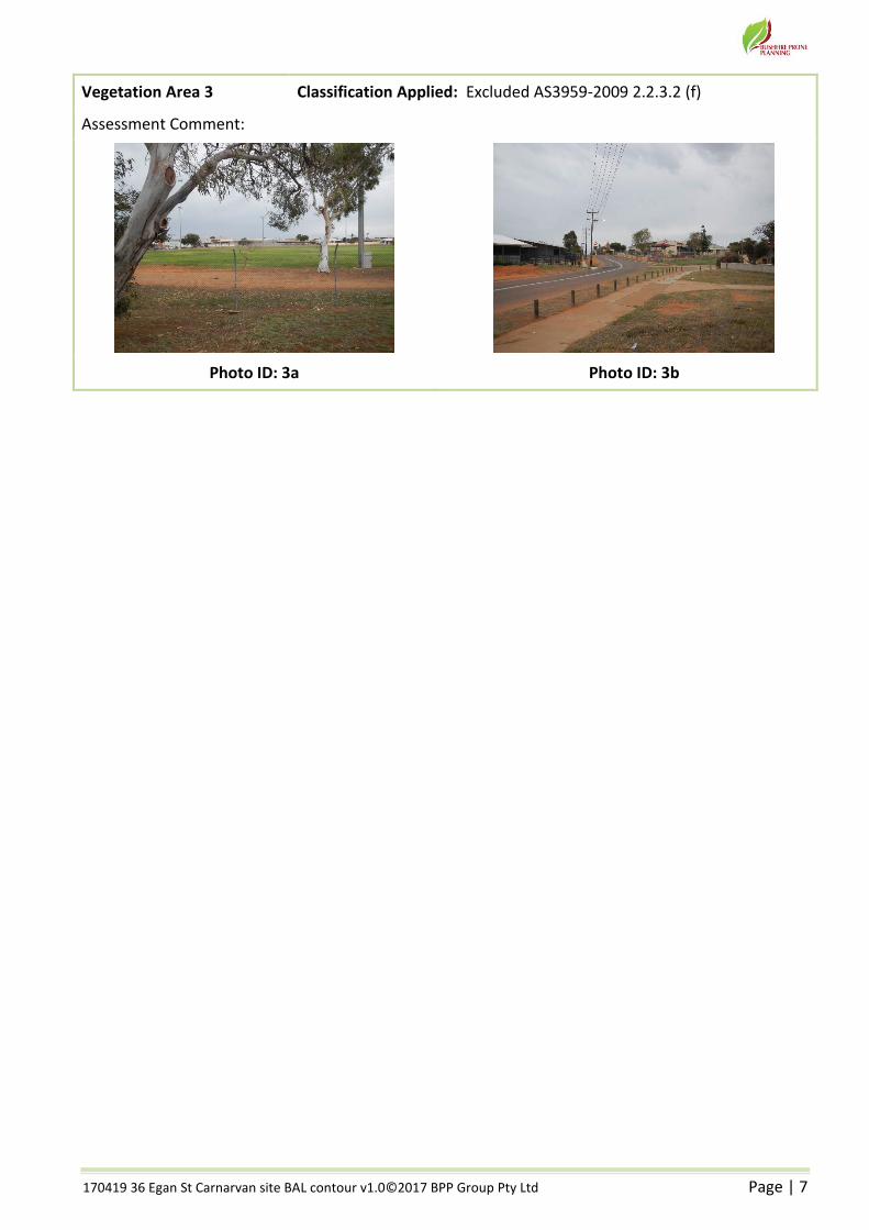
3 Managed parklands and residential areas Excluded AS3959-
2009 2.2.3.2 (f) -

170419 36 Egan St Carnarvan site BAL contour v1.0©2017 BPP Group Pty Ltd Page | 6
Vegetation Area 1 Classification Applied: Class C Shrubland
Assessment Comment: shrubland, flat cross slope gully, samphire, saltbush, minor (acacia?) Shrubs, vegetation height ~2m
Photo ID: 1a Photo ID: 1b
Vegetation Area 1 Classification Applied: Class C Shrubland
Assessment Comment:
Photo ID: 1c Photo ID: 1d
Vegetation Area 2 Classification Applied: Class G Grassland
Assessment Comment: unmanaged areas of grassland and poorly managed public open space
Photo ID: 2a Photo ID: 2b
170419 36 Egan St Carnarvan site BAL contour v1.0©2017 BPP Group Pty Ltd Page | 7
Vegetation Area 3 Classification Applied: Excluded AS3959-2009 2.2.3.2 (f)
Assessment Comment:
Photo ID: 3a Photo ID: 3b

170419 36 Egan St Carnarvan site BAL contour v1.0©2017 BPP Group Pty Ltd Page | 8
3. Bushfire Attack Level (BAL) Assessment – BAL Contour Map
Bushfire Prone Planning’s BAL Contour Map Guide
Description and Purpose of the BAL Contour Map (‘Guidelines’)
A Bushfire Attack Level (BAL) Contour Map identifies land suitable and unsuitable for development
and guides the location of building envelopes within a development site. The BAL Contour Map is a
scale map of a development site (which can include proposed or an existing lot layout), which
identifies indicative BAL ratings across the development site and within the immediate surrounding
area. The map illustrates potential bushfire attack levels and radiant heat impacts in relation to any
classified vegetation that will remain within 100 metres of the assessment area once development is
constructed i.e. when the land has been cleared and all the subdivision works have been undertaken.
It needs to take into account any vegetation that will remain or will be introduced when the works
are complete (source: WAPC Factsheet “BAL Contour Maps” Version 2 January 2016).
BAL Contour Map Interpretation
The contour map will present different coloured contour intervals constructed around the classified
bushfire prone vegetation. These represent the different Bushfire Attack Levels (BAL’s) that exist as
the distance increases away from the classified vegetation. Each BAL represents a set range of radiant
heat flux (refer to Appendix 2) that can be generated by the bushfire in that vegetation. The width of
each shaded contour interval (i.e. the applicable vegetation separation distances corresponding to a
BAL rating) will vary and is determined by calculations involving vegetation type, fuel structure,
ground slope, and climatic conditions (i.e. the expected fire behaviour). They are unique to a site and
can vary across a site.
The Primary Use of BAL Contour Mapping - Planning
BAL contour mapping is primarily a planning tool that can give an overview as to the suitability of a
site for development with respect to the extent to which bushfire is a potential threat to future
buildings and persons on the subject land.
The mapping considers the development site (i.e. all existing or proposed lots) and does not consider
the bushfire risk at an individual lot level or over different development time frames. Rather it is
assessing the situation that will exist when the entire development has been completed, including any
vegetation management that would reasonably be expected to take place as part of establishing
buildings on the lots. On this basis, it helps decision makers determine the suitability of the proposed
development for planning approval.

ROBIN
SON ST
AIRPORT CR
STUART ST
JAMES ST
FRANCIS ST
JOHNSTON ST
RUSH
TON S
T
AIRPORT CR
OLIVIA TCE
RUSH
TON S
T
STUART ST
HILL ST
CLEAV
ERST
EGAN ST
ROBIN
SON S
T
ROBINSON ST
CARNARVON RD
L o t 3 2 4L o t 3 2 4
____________ LEGEND ____________
Lot 324Other Lots Area of Interest - 150m extent
Bushfire Attack LevelsVegetation edge (Indicative only)BAL FZ (Indicative only)BAL 40 (Indicative only)BAL 29 (Indicative only)BAL 19 (Indicative only)BAL 12.5 (Indicative only)BAL LOW (Indicative only)
0 25 50 75 100
Metres
____________ SCALE (A3) ____________
Disclaimer and Limitation: This map has been prepared for bushfire management planning purposes only. All depicted areas, contours and any dimensions shown are subject to survey. Bushfire Prone Planning does not guarantee that this map is without flaw of any kind and disclaims all liability for any errors, loss or other consequence which may arise from relying on any information depicted.
Map created on: 12/09/2017Map compiled by: Rebecca King
Coordinate System: GDA 1994 MGA Zone 50Projection: Universal Transverse Mercator
S H A R KS H A R KB A YB A Y
I N G G A R D AI N G G A R D A
I N G G A R D AI N G G A R D A
G R E Y SG R E Y SP L A I NP L A I N
CARNARVON
__________ LOCALITY __________
p
BAL Contour Map
Lot 324, 39 Egan StreetCarnarvon
Aerial Image: Landgate Nov 2015

170419 36 Egan St Carnarvan site BAL contour v1.0©2017 BPP Group Pty Ltd Page | 10
Construction of the BAL Contours - Statement of Site Data and ‘Separation Distance Range’ Applied
For the subject site, the vegetation separation distance range that corresponds to each Bushfire Attack Level (and represented by the BAL Contour Map), has been derived from:
1. An AS3959-2009 Method 1 assessment and sourced from AS3959-2009 Table 2.4.3
.
Statement of Site Data and ‘Separation Distance Range’ Applied
Vegetation
Area
BAL Assessment Method
Used
Site Data Applied in the BAL
Assessment
Separation Distance Range
Applied/Determined
1-2 AS3959-2009 Method 1 Refer to Section 2
The distance
corresponding to each
BAL Rating as per AS3959-
2009 Table 2.4.3
Separation Distances Represented by the Mapped BAL Contours
Separation Distances (metres) – Method 1 (sourced from AS3959-2009 Table 2.4.3)
Vegetation Area BAL Rating
BAL-FZ BAL-40 BAL-29 BAL-19 BAL12.5
1 - Shrubland, 0 deg, cross slope <7 7-<9 9-<13 13-<19 19-<100
2 - Grassland, 0 deg, up slope <6 6-<8 8-<12 12-<17 17-<50

170419 36 Egan St Carnarvan site BAL contour v1.0©2017 BPP Group Pty Ltd Page | 11
Appendices – Advisory Information Only
Appendix 1
Explaining Asset Protection Zones (APZ)
Description: An APZ is an area surrounding a building that is managed to reduce the bushfire hazard
to an acceptable level (by reducing fuel loads). The width of the required APZ varies with slope and
vegetation. For planning applications, the minimum sized acceptable APZ is that which is of sufficient
size to ensure the potential radiant heat impact of a fire does not exceed 29kW/m² (BAL-29). It will
be site specific.
(For subdivision planning, hazard separation in the form of using subdivision design elements or
excluded and low threat vegetation adjacent to the lot may be used to reduce the dimensions of the
APZ within the lot).
Defendable Space: The APZ includes a defendable space which is an area adjoining the asset within
which firefighting operations can be undertaken to defend the structure. Vegetation within the
defendable space should be kept at an absolute minimum and the area should be free from
combustible items and obstructions. The width of the defendable space is dependent on the space
which is available on the property, but as a minimum should be 3 metres.
Establishment: The APZ should be contained solely within the boundaries of the lot on which the
building is situated, except in instances where the neighbouring lot or lots will be managed in a low-
fuel state on an ongoing basis, in perpetuity. The APZ may include public roads, waterways,
footpaths, buildings, rocky outcrops, golf courses, maintained parkland as well as cultivated gardens
in an urban context, but does not include grassland or vegetation on a neighbouring rural lot,
farmland, wetland reserves and unmanaged public reserves.
Native Vegetation: APZ’s can adversely affect the retention of native vegetation. Where the loss of
vegetation is not acceptable or causes conflict with landscape or environmental objectives, such as
waterway foreshore areas and wetland buffers, reducing lot yield may be necessary to minimise the
removal and modification of remnant vegetation.
Responsibility: It is the responsibility of the landowner/proponent to maintain their APZ in
accordance with the ‘Guidelines’ Appendix 4 Schedule 1 ‘Standards for Asset Protection Zones’
(WAPC 2017). It is likely that this requirement is also contained in the firebreak notice issued by the
relevant local government under s33 of the Bushfire Act 1954 along with any additional
requirements.
Source: Guidelines for Planning in Bushfire Prone Areas (WAPC 2017 v1.1) Appendix 4 Element 2
.

170419 36 Egan St Carnarvan site BAL contour v1.0©2017 BPP Group Pty Ltd Page | 12
Standards for Asset Protection Zones
(‘Guidelines’ WAPC 2017 v1.1 Appendix 4 Schedule 1)
Fences: within the APZ are constructed from non-combustible materials (e.g. iron, brick, limestone,
metal post and wire). It is recommended that solid or slatted non-combustible perimeter fences are
used.
Objects: within 10 metres of a building, combustible objects must not be located close to the
vulnerable parts of the building i.e. windows and doors.
Fine Fuel Load: combustible dead vegetation matter less than 6 mm in thickness reduced to and
maintained at an average of two tonnes per hectare. The visual guide below shows a fuel load that
equates to approximately 2t/ha (source: Shire of Augusta Margaret River’s Firebreak and Fuel
Reduction Hazard Notice).
Trees (> 5 metres in height): trunks at maturity should be a minimum distance of 6 metres from all
elevations of the building, branches at maturity should not touch or overhang the building, lower
branches should be removed to a height of 2 metres above the ground and or surface vegetation,
canopy cover should be less than 15% with tree canopies at maturity well spread to at least 5 metres
apart as to not form a continuous canopy. Diagram below represents tree canopy cover at maturity.
Shrubs (0.5 metres to 5 metres in height): should not be located under trees or within 3 metres of
buildings, should not be planted in clumps greater than 5m2 in area, clumps of shrubs should be
separated from each other and any exposed window or door by at least 10 metres. Shrubs greater than
5 metres in height are to be treated as trees.
Ground covers (<0.5 metres in height): can be planted under trees but must be properly maintained
to remove dead plant material and any parts within 2 metres of a structure, but 3 metres from windows
or doors if greater than 100 mm in height. Ground covers greater than 0.5 metres in height are to be
treated as shrubs.
Grass: should be managed to maintain a height of 100 mm or less.

170419 36 Egan St Carnarvan site BAL contour v1.0©2017 BPP Group Pty Ltd Page | 13
Note that individual local governments may set their APZ standards with additional requirements
compared to the standard set in the ‘Guidelines’. These will be contained in their annual firebreak
notice issued under s33 of the Bushfires Act 1954 and are to be complied with.
The example diagrams below illustrate how the required dimensions of the APZ will be determined by
the type and location of the vegetation
Additional DFES Guidance
a) Store firewood at least 20 metres away from the building.
b) Keep gutters free of leaves and other combustible material.
c) Roof mounted evaporative coolers to be fitted with ember screens.
d) Gas cylinders to vent away from a building and be tethered to prevent falling over.
e) Driveways and access ways must allow for safe passage of a fire appliance to all buildings on the
land.
f) Land owners/occupiers must maintain compliance with the local government’s annual firebreak
notice issued under s33 of the Bush Fires Act 1954.
Regardless of whether an Asset Protection Zone exists in accordance with the acceptable solutions
and is appropriately maintained, it should be noted that fire fighters are not obliged to protect an
asset if they think the separation distance between the dwelling and vegetation is unsafe.

170419 36 Egan St Carnarvan site BAL contour v1.0©2017 BPP Group Pty Ltd Page | 14
Appendix 2
Managing the Asset Protection Zone
It is the responsibility of the landowner to maintain the established bushfire protection measures on
their property. This includes maintaining an asset protection zone (APZ) of the required dimensions, as
a non-vegetated area or as low threat vegetation managed to a minimal fuel condition, as defined in
the APZ standard (refer to Appendix 1) and AS 3959-2009 s2.2.3.2 part (f) (see below).
The required dimensions of the APZ will vary dependent upon the purpose for which the APZ has been defined (which is determined by the purpose of this assessment). There are effectively three APZ dimensions that can apply:
1. An application for planning approval will be required to show that an APZ can be created which
is of sufficient size to ensure the potential radiant heat impact of a fire does not exceed
29kW/m² (BAL-29); and
2. If the assessment has determined a BAL rating for an existing or future building is less than BAL-
29, the APZ must be of a size such that the vegetation separation distances correspond to the
lower BAL rating to maintain that BAL rating; or
3. Complying with the relevant local governments annual firebreak notice can result in an APZ of
greater size than that defined by the two previous parameters.
The dimensions (vegetation separation distances) that are to apply to the APZ for this Proposal are presented in the tables below.
The ‘Planning’ APZ - Minimum Dimensions for this Site (WAPC)
Requirement Set By Guidelines for Planning in Bushfire Prone Areas (WAPC 2017 v1.1)
Relevant Fire Danger Index (AS3959-2009 Table 2.1) 80
BAL Determination Method Method 1 (as per AS 3959-2009 s2.2.6 and Table 2.4.3)
Vegetation Area
(refer to Site Assessment
Map)
Applied Vegetation Classification
Effective
Slope
(degrees)
Minimum
Separation
Distance
Required
(metres)
1 Class C Shrubland 0 9
2 Class G Grassland 0 8
3 Excluded AS3959-2009 2.2.3.2 (f) - -
This requirement has been established through the State bushfire provisions to determine the compliance
capability of a planning application for any subdivision/development in WA (refer to Appendix 1).
170419 36 Egan St Carnarvan site BAL contour v1.0©2017 BPP Group Pty Ltd Page | 15
‘Local Government Firebreak Notice APZ’ - Minimum Dimensions
Requirement Set By: Shire of Carnarvon
Minimum Dimensions: 20m
Other Conditions: The APZ must be maintained as per the APZ requirements set out in
Appendix 1.
This requirement has been established through the local governments annual fire break notice issued under
the Bushfires Act 1954 s33.
.
Extract from AS 3959-2009 Section 2.2.3.2 – low threat vegetation definition
The Bushfire Attack Level shall be classified BAL-LOW where the vegetation is one or a combination of
the following:
a), b), c), d), e) – not relevant to vegetation management within the APZ.
f) low threat vegetation, including grassland managed in a minimal fuel condition (i.e. insufficient fuel
available to significantly increase the severity of a bushfire attack – recognisable as short cropped grass
to a nominal height of 100mm for example), maintained lawns, golf courses, maintained public
reserves and parklands, vineyards, orchards, cultivated gardens, commercial nurseries, nature strips
and windbreaks.

170419 36 Egan St Carnarvan site BAL contour v1.0©2017 BPP Group Pty Ltd Page | 16
Appendix 3
Explaining Bushfire Attack Levels and Radiant Heat
Definition: A Bushfire Attack Level (BAL) is a “means of measuring the severity of a building’s potential
exposure to ember attack, radiant heat and direct flame contact, using increments of radiant heat flux
expressed in kilowatts per metre squared, and is the basis for establishing the requirements for construction
to improve protection of building elements from attack by bushfire.” AS 3959-2009 Construction of Buildings
in Bushfire Prone Areas.
AS 3959-2009 defines six categories of Bushfire Attack Level (AS 3959-2009 Appendix G) and provides the
assessment methodology (AS 3959-2009 s2 and Appendix B) to calculate Bushfire Attack Levels. Two methods
are provided, Method 1 is the simplified procedure but is subject to some limitations in the circumstances in
which it can be used. Method 2 is a detailed procedure and is to be used where a more specific result is sought
or site conditions are outside the scope of Method 1. The standard then specifies the construction requirements
that correspond to each BAL rating (AS 3959 s3 Table 3.1 and s5 to s9).
Bushfire Attack Level
Description of Predicted Bushfire Attack and Levels of Heat Flux Exposure (Source: AS 3959-2009, Appendix G and Table 3.1)
BAL - LOW There is insufficient risk to warrant specific construction requirements but there is still some risk.
BAL - 12.5 There is risk of ember attack. The construction elements are expected to be exposed to a heat
flux not greater than 12.5 kW/m2
BAL - 19
There is a risk of ember attack and burning debris ignited by wind borne embers and a likelihood
of exposure to radiant heat. The construction elements are expected to be exposed to a heat
flux not greater than 19 kW/m2
BAL - 29
There is an increased risk of ember attack and burning debris ignited by wind borne embers and
a likelihood of exposure to an increased level of radiant heat. The construction elements are
expected to be exposed to a heat flux not greater than 29 kW/m2
BAL - 40
There is a much-increased risk of ember attack and burning debris ignited by wind borne
embers, a likelihood of exposure to a high level of radiant heat and some likelihood of direct
exposure to flames from the fire front. The construction elements are expected to be exposed to
a heat flux not greater than 40 kW/m2
BAL - FZ
There is an extremely high risk of ember attack and burning debris ignited by wind borne
embers, a likelihood of exposure to an extreme level of radiant heat and direct exposure to
flames from the fire front. The construction elements are expected to be exposed to a heat flux
greater than 40 kW/m2

170419 36 Egan St Carnarvan site BAL contour v1.0©2017 BPP Group Pty Ltd Page | 17
Radiant Heat – Explanation and Perspective
Radiant heat is the heat that you feel from a fire (campfire or heater). Radiant heat is the biggest killer in a fire.
The human body cannot absorb large amounts of radiant heat without its cooling system failing, leading to heat
exhaustion and heart failure.
Radiant heat is invisible, travels in straight lines, radiates out from a bushfire ahead of the flames and will bounce
off solid objects, although it will travel through glass.
Radiant heat can be blocked by a solid object or barrier such as a brick/concrete wall or building and suitable
clothing – but this partial protection from radiant heat may still not save your life. Radiant heat can crack or
break windows, allowing embers to enter a building and can ignite exposed surfaces without direct flame
contact.
The best protection from radiant heat is distance. If the distance from the fire is doubled, the radiant heat load
can be reduced by four times. You can greatly reduce potential radiant heat and direct flame contact around
dwellings by carefully managing the vegetation.
Typical Radiant
Heat Flux
(kW/m2)
Likely Effects (1) The radiant heat flux levels are indicative values and the likely effects are an aggregation of various research. Extended duration of exposure can result in
the effect occurring at lower radiant heat flux level.
Approx. Vegetation Separation Distance (2)
(m)
1 The average radiant heat flux from the sun at midday on a summer’s day. 1.6 kW/m2
acceptable limit for prolonged exposure. 180
2 Pain to unprotected humans after I minute. 125
3 Hazardous conditions. Firefighter in protective clothing expected to operate for a short period (<10 minutes).
100
4 Pain to unprotected humans after 20 seconds. No lethality, 2nd degree burns probable. 61
5 Extreme conditions. Firefighter in protective clothing will feel pain after one minute of exposure.
75
7 Likely fatal to unprotected humans after exposure for several minutes. 61
10 Firefighters not expected to operate in these conditions although they may be encountered. Considered to be life threatening < 1 minute in protective equipment. Piloted (e.g. embers) ignition of textile fabrics in enclosed spaces may occur.
49
13 Standard float glass may crack and with longer exposure may fail. Piloted (e.g. embers) ignition of lightweight textile furnishings may occur. Piloted ignition of timber may occur with long exposure. Lethality to humans 1% in 1 min, 1st degree burns in 10 sec.
40
19 Screened float glass could fail. 31
25 Piloted (e.g. embers) ignition of timber may occur (spontaneous if long exposure). Lethality to humans 100% in 1 min, significant injury in 10 sec.
24
29 Toughened glass could fail. Spontaneous ignition of most timbers with >3 minutes exposure.
21
38 Spontaneous ignition of lightweight textile furnishings can occur (short exposure). Lethality to humans 100% in 1 min, 1% in 10 sec.
17
45 Spontaneous ignition of timbers can occur in 20 seconds. 15
>29 - 100 Within the Flame Zone (BAL-40 and BAL-FZ). During a high-intensity head fire, radiant heat fluxes in excess of 150 kW/m2 have been measured.
0-21
(1) Sources: AS 1530.4 – 2005, CSIRO, RFS NSW, Warrington Fire Research (literature review on bushfire construction), Assael and Kakosimos, 2010, Fires, explosions, and toxic gas dispersions: effects calculation and risk, CRC Press, Florida (2) Modelled using AS 3959-2009 methodology for a forest fire on flat ground with FDI 80 and default fuel loads.
170419 36 Egan St Carnarvan site BAL contour v1.0©2017 BPP Group Pty Ltd Page | 18
Appendix 4
Building Applications (Building Permit) and the Requirement for a Bushfire Attack Level (BAL) Assessment
Most development in WA requires the submission of a building application in order to obtain a building
permit before construction can commence. The proposed construction must comply with the Building
Code of Australia (BCA).
In a designated bushfire prone area, construction, renovation, alteration, extension, improvement or
repair of residential buildings (Classes 1, 2, 3 and associated Class 10a buildings or decks), must comply
with the bushfire construction requirements of the BCA.
The BCA references AS 3959-2009 ‘Construction of buildings in bushfire prone areas’ and the NASH
Standard 'Steel Framed Construction in Bushfire Areas', as providing deemed to satisfy solutions that
achieve compliance with the BCA bushfire performance requirements.
A Bushfire Attack Level (BAL) assessment (using the methodology set out in AS 3959-2009) is required
to determine the BAL rating of the proposed building work. The corresponding design and construction
requirements are then able to be determined.
Class 4 to Class 9 buildings will also require a BAL assessment but are not required (by the BCA for WA) to comply with the bushfire construction requirements. However, the requirement to comply may be established by the responsible authority or the requirements might also be voluntarily adopted. For these class of buildings, the bushfire provisions use the planning process to focus on location, siting and design, vehicular access and firefighting water supply to mitigate the bushfire risk. In certain situations, if the determined BAL is BAL-40 or BAL-FZ and/or for certain types of building, the State and/or local government bushfire provisions for planning are triggered and this will require the submission of a development application and the provision of additional assessments against the Bushfire Protection Criteria as set out in State Planning Policy 3.7 Planning in Bushfire Prone Areas and the Guidelines for Planning in Bushfire Prone Areas (WAPC 2017 v1.1).

_
Perth Level 12, 3 Hasler Road Locked Bag 9 Osborne Park WA 6017 Australia
T 08 9317 0600 F 08 9317 0611 [email protected] veris.com.au