15pr5 - international society for photogrammetry and ... · 15pr5 ~ "1993 progress and ......
TRANSCRIPT

1993 Annual Report ofthe
International Society for Photogrammetry and Remote Sensing
~
15PR5 ~
"1993 Progress and Activities in Photogrammetry and Remote Sensing"
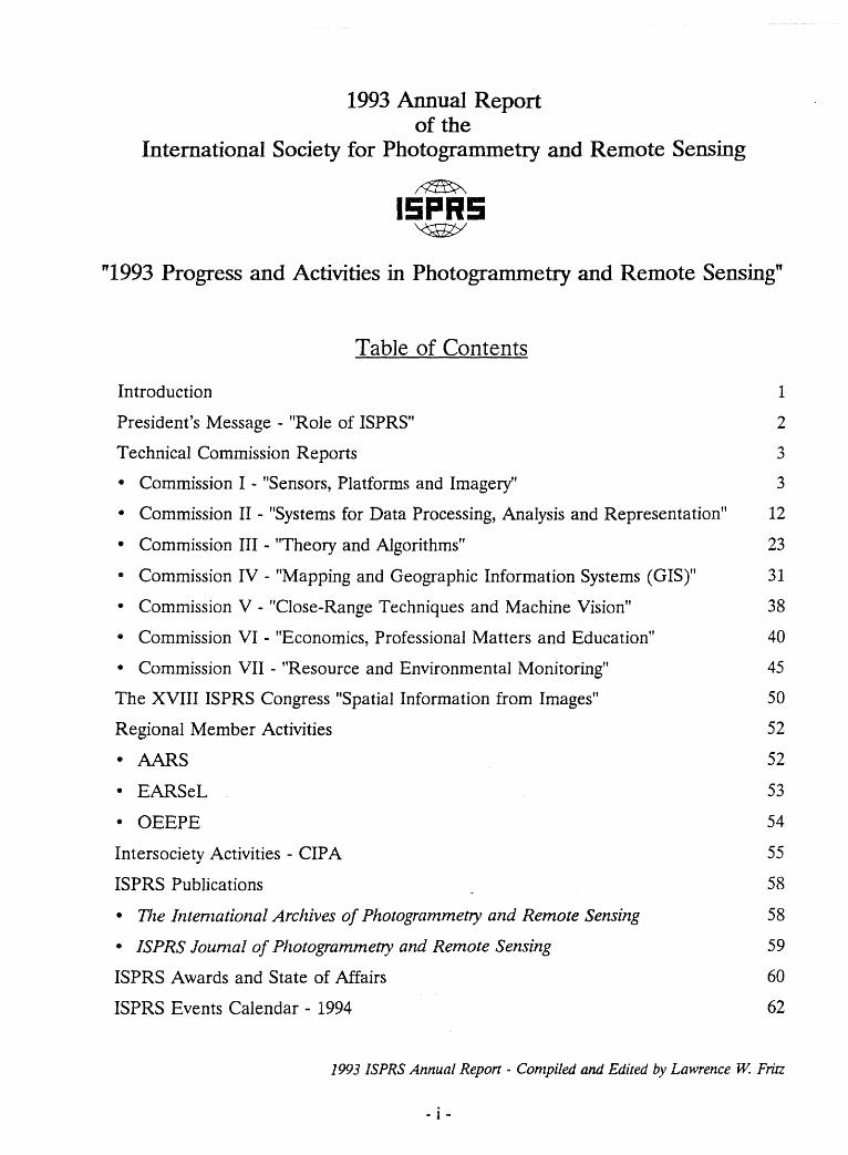
Table of Contents
Introduetion 1
President's Message - "Role of ISPRS" 2
Teehnieal Commission Reports 3
• Commission I - "Sensors, Platforms and Imagery" 3
• Commission II - "Systems for Data Proeessing, Analysis and Representation" 12
• Commission III - "Theory and Algorithms" 23
• Commission IV - "Mapping and Geographie Information Systems (GIS)" 31
• Commission V - "Close-Range Teehniques and Maehine Vision" 38
• Commission VI - "Eeonomics, Professional Matters and Edueation" 40
• Commission VII - "Resouree and Environmental Monitoring" 45
The XVIII ISPRS Congress "Spatial Information from Images" 50
Regional Member Aetivities 52
• AARS 52
• EARSeL 53
• OEEPE 54
Intersociety Aetivities - CIP A 55
ISPRS PubIieations 58
• The Illtenzational Archives o[ Photogrammetry alld Remote Sensing 58
• ISPRS lounzal o[ Photogrammetry and Remote Sensing 59
ISPRS Awards and State of Affairs 60
ISPRS Events Calendar - 1994 62
1993 ISPRS Annual Report - Compiled anti Edited by Lawrence W. Fritz
- i -
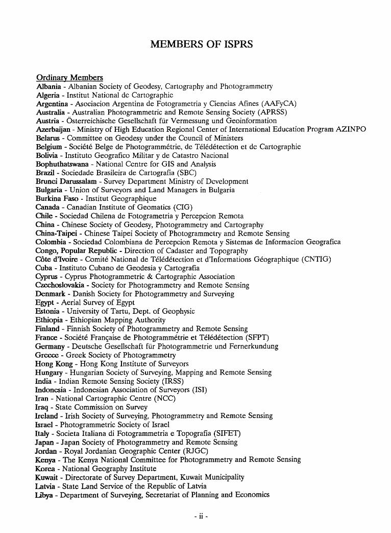
MEMBERS OF ISPRS
Ordinary Members Albania - Albanian Society of Geodesy, Cartography and Photogrammetry Algeria - Institut National de Cartographie Argentina - Asociacion Argentina de Fotogrametria y Ciencias Afines (AAFyCA) Australia - Australian Photogrammetric and Remote Sensing Society (APRSS) Austria - Österreichische Gesellschaft für Vermessung und Geoinformation Azerbaijan - Ministry of High Education Regional Center of International Education Program AZINPO Belarus - Committee on Geodesy under the Council of Ministers Belgium - Societe BeIge de Photogrammetrie, de Teledetection et de Cartographie Bolivia - Instituto Geografico Militar y de Catastro N acional Bophuthatswana - National Centre for GIS and Analysis Brazil - Sociedade Brasileira de Cartografia (SBC) Brunei Darussalam - Survey Department Ministry of Development Bulgaria - Union of Surveyors and Land Managers in Bulgaria Burma Faso - Institut Geographique Canada - Canadian Institute of Geomatics (CIG) Chile - Sociedad Chilena de Fotogrametria y Percepcion Remota China - Chinese Society of Geodesy, Photogrammetry and Cartography China-Taipei - Chinese Taipei Society of Photogrammetry and Remote Sensing Colombia - Sociedad Colombiana de Percepcion Remota y Sistemas de Informacion Geografica Congo, Popular Republic - Direction of Cadaster and Topography Cöte d'Ivoire - Comite National de Teledetection et d'Informations Geographique (CNTIG) Cuba - Instituto Cubano de Geodesia y Cartografia Cyprus - Cyprus Photogrammetric & Cartographic Association Czechoslovakia - Society for Photogrammetry and Remote Sensing Denmark - Danish Society for Photogrammetry and Surveying Egypt - Aerial Survey of Egypt &tonia - University of Tartu, Dept. of Geophysic Ethiopia - Ethiopian Mapping Authority Fmland - Finnish Society of Photogrammetry and Remote Sensing France - Societe Fran~aise de Photogrammetrie et Teledetection (SFPT) Germany - Deutsche Gesellschaft für Photogrammetrie und Fernerkundung Greece - Greek Society of Photogrammetry Hong Kong - Hong Kong Institute of Surveyors Hungary - Hungarian Society of Surveying, Mapping and Remote Sensing India - Indian Remote Sensing Society (IRSS) Indonesia - Indonesian Association of Surveyors (ISI) Iran - National Cartographic Centre (NCC) Iraq - State Commission on Survey Ireland - Irish Society of Surveying, Photogrammetry and Remote Sensing Israel - Photogrammetric Society of Israel Italy - Societa Italiana di Fotogrammetria e Topografia (SIFET) Japan - Japan Society of Photogrammetry and Remote Sensing Jordan - Royal Jordanian Geographie Center (RJGC) Kenya - The Kenya National Committee for Photogrammetry and Remote Sensing Korea - National Geography Institute Kuwait - Direetorate of Survey Department, Kuwait Municipality Latvia - State Land Service of the Republie of Latvia Lt'bya - Department of Surveying, Secretariat of Planning and Economics
- 11 -
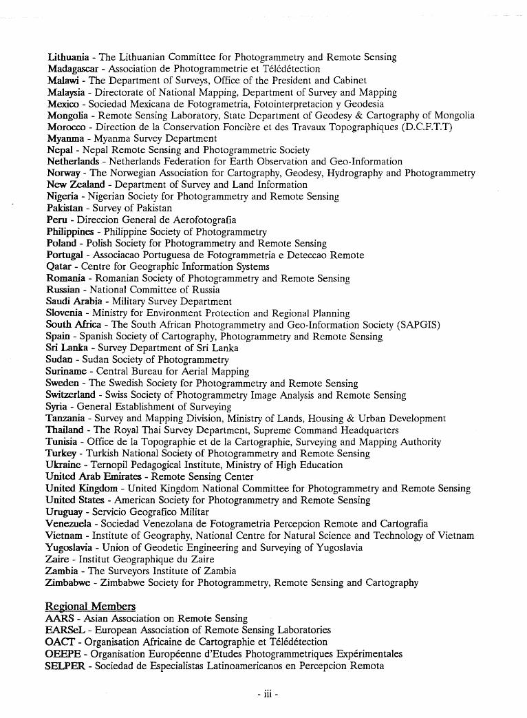
Lithuania - The Lithuanian Committee for Photogrammetry and Remote Sensing Madagascar - Association de Photogrammetrie et Teledetection Malawi - The Department of Surveys, Office of the President and Cabinet Malaysia - Directorate of National Mapping, Department of Survey and Mapping Mexico - Sociedad Mexicana de Fotogrametria, Fotointerpretacion y Geodesia Mongolia - Remote Sensing Laboratory, State Department of Geodesy & Cartography of Mongolia Morocco - Direction de la Conservation Fonciere et des Travaux Topographiques (D.C.F.T.T) Myanma - Myanma Survey Department Nepal - Nepal Remote Sensing and Photogrammetric Society NetherIands - Netherlands Federation for Earth Observation and Geo-Information Norway - The Norwegian Association for Cartography, Geodesy, Hydrography and Photogrammetry New Zealand - Department of Survey and Land Information Nigeria - Nigerian Society for Photogrammetry and Remote Sensing Pakistan - Survey of Pakistan Peru - Direccion General de Aerofotografia Philippines - Philippine Society of Photogrammetry Poland - Polish Society for Photogrammetry and Remote Sensing Portugal - Associacao Portuguesa de Fotogrammetria e Deteccao Remote Qatar - Centre for Geographie Information Systems Romania - Romanian Society of Photogrammetry and Remote Sensing Russian - National Committee of Russia Saudi Arabia - Military Survey Department Slovenia - Ministry for Environment Protection and Regional Planning South Africa - The South African Photogrammetry and Geo-Information Society (SAPGIS) Spain - Spanish Society of Cartography, Photogrammetry and Remote Sensing Sri Lanka - Survey Department of Sri Lanka Sudan - Sudan Society of Photogrammetry Suriname - Central Bureau for Aerial Mapping Sweden - The Swedish Society for Photogrammetry and Remote Sensing SwitzerIand - Swiss Society of Photogrammetry Image Analysis and Remote Sensing Syria - General Establishment of Surveying Tanzania - Survey and Mapping Division, Ministry of Lands, Housing & Urban Development Thailand - The Royal Thai Survey Department, Supreme Command Headquarters Tunisia - Office de la Topographie et de la Cartographie, Surveying and Mapping Authority Turkey - Turkish National Society of Photogrammetry and Remote Sensing Ukraine - Ternopil Pedagogical Institute, Ministry of High Education United Arab Emirates - Remote Sensing Center United Kingdom - United Kingdom National Committee for Photogrammetry and Remote Sensing United States - American Society for Photogrammetry and Remote Sensing Uruguay - Servicio Geografico Militar Venezuela - Sociedad Venezolana de Fotogrametria Percepcion Remote and Cartografia Vietnam - Institute of Geography, National Centre for Natural Science and Technology of Vietnam Yugoslavia - Union of Geodetic Engineering and Surveying of Yugoslavia Zaire - Institut Geographique du Zaire Zambia - The Surveyors Institute of Zambia Zimbabwe - Zimbabwe Society for Photogrammetry, Remote Sensing and Cartography
Regional Members AARS - Asian Association on Remote Sensing EARSeL - European Association of Remote Sensing Laboratories OACf - Organisation Africaine de Cartographie et Teledetection OEEPE - Organisation Europeenne d'Etudes Photogrammetriques Experimentales SELPER - Sociedad de Especialistas Latinoamericanos en Percepcion Remota
- iii -
President Shunji Murai Institute of Industrial Science University of Tokyo 7-22, Roppongi, Minatoku Tokyo 106, Japan Tel: +81-3-3402 6231 Fax: +81-3-3479 2762
Secretary General Lawrence W. Fritz Martin Marietta Corporation P.O. Box 8048-13A24 Philadelphia, PA 19101, USA Tel: + 1-610-531 3205 Fax: + 1-610-889 3296 or 962 3698
TreasurerJohn C. Trinder University of New South Wales School of Surveying P.O. Box 1, Kensington, NSW 2033 Australia Tel: +61-2-697 4197 Fax: +61-2-313 7493 E-mail: [email protected]
ISPRS COUNCIL
Congress Director Karl Kraus Institute of Photogrammetry & Remote Sensing Vienna University of Technology Gusshausstrasse 27-29 A-1040 Vienna, Austria Tel: +43-1-58801 3811 Fax: +43-1-505 6268
1st Vice President Kennert Torlegard The Royal Institute of Technology Department of Photogrammetry S-lOO44 Stockho!m, Sweden Tel: +46-8-790 7344 Fax: +46-8-790 6610
2nd Vice President Armin W. Gruen ETH -Hoenggerberg Institute of Geodesy & Photogrammetry CH-8093 Zurich, Switzerland Tel: +41-1-633 3038 Fax: +41-1-372 0438 E-mail: [email protected]
JECHNICAL COMMISSION PRESIDENTS
Com I President Luigi Mussio Politecnico di Milano, Dip. I.I.AR Piazza Leonardo da Vinci 32 1-20133 Milano, Italy
Tel: +39-2-2399 6501 Fax: +39-2-2399 6530
Com n President Mosaad Allam Natural Resources Canada GIS Division, Surveys, Mapping &
Remote Sensing Sector 615 Booth Street Ottawa, Canada K1A OE9 Tel: + 1-613-996 2810 Fax: + 1-613-952 0916
Com m President Heinrich Ebner Technical University Munich Photogram. & Remote Sensing Arcisstrasse 21 D-8000 München 2, Germany Tel: +49-89-2105 2671 or 2677 Fax: +49-89-2809573
Com IV President Roy A Welch University of Georgia Center for Remote Sensing &
Mapping Science Department of Geography Athens, GA 30602-2403, USA Tel: + 1-706-542 2359 Fax: + 1-706-542 2358
Com V President John G. Fryer University of Newcastle Department of Civil Engineering
& Surveying Newcastle, N.S.W. 2308 Australia Tel: +61-49-216 049 Fax: +61-49-216 991
Com VI President Li Deren Wuhan Technical University of
Surveying & Mapping Department for Photogrammetry &
Remote Sensing 39 Loyu Road Wuhan, China 430070 Tel: +86-27-7831224 Fax: +86-27-7814185
Com vn President Roberto da Cunha INPE - National Institute of Space
Research CRI - Coordination for Institutional
Relations Av. dos Astronautas 1758 Caixa Postal 515 12201-970 Sao Jose dos Campos SP, Brazil Tel: +55-123-22 9816 Fax: +55-123-21 8743
Cover photograpb: Perspective view of the Grossglockner, the highest mountain in Austria. This image was processed by merging data of Landsat TM (192-27, acquisition date 11 July 1987) and Spot PAN (62-255, acquisition date 21 August 1989). Copyright: GEOSP ACE
- IV -
Martin Marietta Corporation P.O. Box 8048-13A24
Philadelphia, PA 19101 U.S.A.
~
15PR5 '<SJi[;t/
INTRODUCITON Lawrence W Fritz, ISPRS Secretary General
Headquarters 1992-1996 Phone: + 1-610·531-3205 Fax: + 1-610-889-3296
or + 1-610-962-3698
The ISPRS Council met during 2-3 May 1993 with the seven Technical Commission Presidents to review Commission and Working Group activities. In a subsequent CounciI meeting on 5-6 May, Council decided that in the prevailing spirit to be more proactive in fulfiIIing its international role the ISPRS will actively pursue two important activities: Annual Reports and Event Reports.
This document is the first ISPRS Annual Report. It has been prepared and published to meet several ISPRS objectives:
• Promote international cooperation, coordination and advancement of photogrammetry, remote sensing, geographic information systems (GIS) and related sciences.
• Provide timely information on the state of the art research and developments 10 all interested parties.
• Improve communication of ISPRS objectives and activities to other scientific organizations and international forums such as the United Nations, as weIl as 10 ISPRS Member organizations.
• Fulfill reporting requirements of Commissions and Working Groups as prescribed in the ISPRS Bylaws and Guidelines.
The Event Reports are published in the ISPRS Journal of Photogrammetry and Remote Sensing which is published six times annually.
We encourage your comments to help us strive to inform you of the activities of our professions. As with an initiatives, this initial publication may not contain all the information we intended 10 provide. Coordinating input from 47 Working Groups and 7 Technical Commissions from around the world takes time and patience. We ho pe that the information contained herein is of value 10 you. Please feel free to make copies for further distribution.
- 1 -
PRESIDENT'S MESSAGE
"ROLE OF ISPRS" Dr. Shunji Murai, ISPRS President
The mISSIon of the ISPRS is to develop the international cooperation for the advancement of photogrammetry and remote sensing and their applications according to Statute I.
To achieve its aims, the Society promotes the following activities.
a. To hold international Congresses at four year intervals in the Olympie year as weIl as mid-term symposia between the Congresses at the relevant countries responsible for the technical commissions;
b. To initiate and coordinate research in the field of photogrammetry and remote sensing by creating Technieal Commissions and Working Groups concerned with particular as pects of photogrammetry and remote sensing.
c. To ensure wide international circulation of the results of research and records of discussion by the publication of the International Archives of Photogrammetry and Remote Sensing.
d. To publish Official Journal.Photogrammetry and Remote Sensing;
e. To stimulate the formation of aNational Society for Photogrammetry and Remote Sensing in each country and promote exchanges between such Societies;
f. To encourage the publieation and exchange of scientific papers and journals.
Such activities are now being expanded outside of the ISPRS, in cooperation with international organizations such as IUSM (International Union of Survey and Mapping), FIG, ICA, lAG, IHO, CIP A, UN organizations, etc.
One of the most important roles of ISPRS is to look forward to and follow up most advanced science and technology in photogrammetry and remote sensing by restructuring and renaming the Society, Technical Commissions or Working Groups under the leadership of the Council and Technieal Commission presidents as weIl as in cooperation with active members and experts.
- 2 -
Another very important role of the Society is to internationalize and regionalize the Society's activities in terms of technology transfer as weIl as international or regional cooperation particularly in developing countries.
Since our society changed its name from ISP to ISPRS in 1980, a lot of drastie changes have been realized in the following ways.
a. Conventional analog photogrammetry is now being replaced by digital photogrammetry, even though the digital technology is not yet fully operationalized;
b. A wide range of space technologies such as remote sensing satellites, GPS, satellite altimeter and so on is now being integrated into new mapping technology from space; •
c. Information systems for resources and environmental management and/or planning is dominating in our professional works in terms of LIS/GIS or AM/FM, rather than conventional topographie mapping;
d. Close range photogrammetry is now being replaced by machine vision with a focus on real time 3D measurement of objects in motion rather than static measurement;
e. Concept of "global" is now being brought up in the environmental issues, rather than "loeal" matters;
f. PC-based education and training particularly in remote sensing and GIS is required more than conventional training with visual photointerpretation, especially in developing countries.
The above changes naturally drive the Society's structure and activity to a new direction of technology innovation in photogrammetry and remote sensing for the 21st century.
From the above observations, it is obvious that the Society should grow and continuaHy renew itself. I believe it to be the role of the Society, as weH as the responsibility of the President.
TECHNICAL COMMISSION I
"SENSORS, PLATFORMS AND lMAGERY" Dr.Luigi Mussio, Commission I President
Gianfranco Forlani, Commission I Secretary (ITALY)
1ERMS OF REFERENCE
Planning for aerial and space missions.
Design, construction, testing, installation and calibration of analogue and digital imaging sensors.
Design and performance of data reception and preprocessing systems.
Geometrie and radiometrie properties of image data and quality standards and factors (environmental and others) affecting data quality.
Technical systems for recording sensor data, film scanners and auxiliary data (time, position, attitude, etc.) and media (film, magnetic, optical, etc.).
Preprocessing techniques to generate datasets suitable for analysis and measurements (radar image synthesis, multisensor integration, radiometrie and geometric corrections, etc).
ACCOMPLISHMENTS OF COMMISSION I DURlNG REPORT PERIOD
Joint Meeting 0/ Council & Technical Commission Presidents in Stresa (Italy)
The staff of the Technical Commission I (TC I) and the Council of the Italian Society of Surveying and Photogrammetry hosted last October in Stresa the 2nd Joint Meeting of the ISPRS Council & Technical Commission Presidents (C & TCP's). Both the meeting and its preparation required work and care, but at the end we could say that the meeting was a fun success.
Regarding TC I the C & TCP's established six Working Groups, fixed their Terms of Reference and appointed their Chairpersons and Co-Chairpersons.
Workshop in Trento (Italy)
TC I had its 1st Workshop last June in Trento; this was the occasion for the staff of the TC I 10 meet the
- 3 -
Chairpersons and the Co-Chairpersons of the Working Groups (WG's) in a business session. The Workshop on "Digital Sensors and Systems" covered most of the relevant issues of the TC I, sometimes with a tutorial approach, sometimes giving the state of the art.
Furthermore the WG's III/I and III/4 were engaged in the Workshop as cooperating WG's, according to the Terms of Reference, and in the spirit of cooperation between scientific associations, contributions from astronomers from IAU were presented.
The Workshop held 11 technical sessions with invited papers only (34 oral presentations). About 50 people from 7 countries attended the meeting.
Finally, in the spirit of cooperation among Survey and Mapping Societies, the IAG SSG 4.141 offered a half-day Tutorial on Integrated Methodologies in Inverse Problems, taking into account photogrammetrie experiences. It became an IUSM activity by an action of the ISPRS Vice-President Prof. Kennert Torlegard.
On behalf of the Council, the Co-Chairman of an "Ad-hoc Committee on E-mail Service in ISPRS", promoted the creation of an archive of e-mail addresses to be used for communication within ISPRS. Therefore with the approval of John Fryer (the Chairman of this Committee) a sampie of e-mail addresses within ISPRS officials has been collected. The number of people replying should provide a picture of the real interest of the ISPRS members. Actually about a half of expected answers have been received back.
STATE OF SCIENCE AND TECHNOLOGY OF COMMISSION I TOPICS
The Workshop in Trento provided an up-1O-date picture of Commission Topics. The tendency towards system integration has been stressed especially to support AT: GPS integration with INS and laser ranging showed high performance. Also the use of SAR da ta (and especially interferometrie SAR data) for DTM generation and change detection showed impressive
performances and potential and its integration with photogrammetry for mapping purposes should be promoted. Many operational issues still arise when systems are placed into the produetion environment, while, from the mathematical point of view, eombined adjustment teehniques are already intensively used. Geometrie and radiometrie performances of off-the-shelf scanners and printers were investigated for use in low cost photogrammetrie systems. While results for laser printers look rather poor, it has been shown that scanners can be efficiently calibrated to subpixel accuracy and that their radiometrie quality is generally good and sufficiently stable, though it is necessary to verify it.
Automatie extraetion of information from scanned maps showed efficient teehniques, also ineorporating knowledge-based algorithms for classification; automatie map revision and data capture for GIS were also presented. Algorithms seems to be relatively robust in feature identification, due to the limited set of objeets represented.
Digital data storage and arehiving is still an open problem in different areas, from high speed solid state cameras to remote sensing data from satellite: data eompression algorithms have been illustrated with respeet to their effeet on accuracy degradation; a review of the storage devices available have been given. While originating from different environments and with speeifie eharaeteristics, problems coming from handling in an efficient way digital da ta in photogrammetry and remote sensing are far from having been solved.
In Data Quality Control the application of non parametrie statistics in order to evaluate the degree of up-to-dateness of the information stored in GIS has been suggested, while the concepts of fuzzy data classification have been introduced.
COMMISSION I NEWS
Middle Term Symposium
The middle term Symposium will be held in September 1994 in Villa Olmo, Corno, an old villa upon the lake that is the seat of Centro A. Volta - Symposium Seeretariat, whieh has a special agreement with the Teehnical University of Milan.
The first day a full-day Tutorial on "Mierowave Sensors, Calibration and Data Processing" and a half-day Tutorial on "Acquisition, Charaeterization and Arehiving of Digital Imagery" are foreseen, while the remaining days the Symposium on Primary Data
- 4 -
Acquisition and Evaluation will continue with 20 parallel sessions, and poster sessions.
Since the middle term Symposium folIows immediately the TC III middle term Symposium, the staffs of both Commissions have decided to work in close contaets, to link the two Symposia in terms of information and by offering many attraetive possibilities to go from Munieh to Milan and Corno.
The seheduling will run aeeording to the following time table: - Sept. 93 1st Cireular and Call for Papers - Jan. 94 Deadline for Abstracts Pre-registration - Mar. 94 Notification of Acceptance Information
about Tutorials, Registration and Accommodation Forms
- May 94 Deadline for Complete Manuseripts Early Registration
- June 94 2nd Cireular with Preliminary Program
The 1st Cireular was spread out in 800 copies, 500 of whieh abroad.
Minor Activities
The TC I staff promoted and satisfied several contaets with different parts of the ISPRS and some sister societies, taking into account both scientifie and organizational aspeets.
Thus the President gave a leeture last February in Munieh on General Approximation in Photogrammetry and Cartography, while the President of the TC BI prof. Heinrich Ebner was invited last June in Milan, to give a leeture on Geometrie and Semantie Aspects of Digital Image Processing; the Chairperson of the OEEPE Working Group on the Analysis ofPhoto-Scanners prof. Otto Koelbl has been invited next April in Milan, 10
give a leeture on Evaluation of Scanner Performance.
Furthermore the President was last Summer at CERGA in Grasse (France) for a stage on sequential linear algebra algorithms, in cooperation with astronomers of lAU, and the Seeretary attended last May in Naples (Italy) a Workshop on SAR Interferometry, organized by CO.RI.S.T.A., JPL and EAF .. SeL and gave last September in Rimini (Italy), at the Italian Society of Surveying and Photogrammetry Congress, an invited leeture on the Algorithms of Digital Photogrammetry.
Further Activities
TC I will have a 2nd Workshop on Multimedia GIS Data in June 1995 in Udine (Italy), where the WG III/4
will offer a Tutorial on "Spatial Data Analysis: Theory and Algorithms."
More activities are scheduled or foreseen for the WG's:
- WG I/5 and its corresponding WG within OEEPE will join in a Meeting on Analysis of Photo-Scanners next February in Lausanne (Switzerland);
- WG's I/4 and 1/6 will have a Meeting on Recent Advances in Signal Evaluation on occasion of IUGG General Assembly, in July 1995 in Boulder (Colorado, USA);
- WG 1/2 will attend as cooperating WG the WG III/l Conference, in September 1995 in Barcelona (Spain);
- WG's 1/3 and V /2 are expected to join in a Meeting on Digital Imaging Sensors and Systems, in winter 1995 in Zurich (Switzerland);
- WG I/I could organize in autumn 1995 in Parma (ltaly) a Thinkshop on Data Quality Control, where the WG III/4 should attend as cooperating WG.
GENERAL COMMENTS CONCERNING COMMISSION I WORK AND COMMENTS ON
ISPRS BUSINESS
General Objectives
In the last decade the. nature of the primary data has strongly changed. Platforms on board of satellites, new sensors, the different roles of geodesy and cartography have opened new horizons and shown new directions 10
scientists and engineers. Indeed the contribution of the GPS, INS and laser profile, the imagery from SPOT, SAR (with special regard to its interferometric use), three line cameras, CCD sensors and scanners, the role of GIS have changed not only the nature of the primary data, but also the methodologies to acquire and evaluate them. The further developments of these techniques and methodologies are very important for the advance in photogrammetry, remote sensing and related sciences, as much for the research as for the applications.
The Commission activities should combine suitably the longstanding experiences and the results coming from the application of new techniques and methodologies 10
acquire and evaluate primarydata. The aim is 10 bring together expert from various disciplines; therefore scientists, engineers and users in the fields of photogrammetry, remote sensing, geodesy, electronics and computer science coming from universities, research institutes, govemmental organizations, industries and
- 5 -
engineering firms are kindly invited to participate in TC I activities.
WG's Activities
All WG's were heavily engaged in the Trento Workshop, which provided the first occasion to meet and 10 start really their activities.
During this Workshop a Business Commission was held to plan future activities. All Chairpersons and Co-Chairpersons were asked to get in touch with people interested with their WG activities. Indeed while the Italian contributions and those from Chairperson's and Co-Chairperson's countries are satisfac1Ory, the number of other contributions is limited.
Business Commissions are scheduled, after the Trento Meeting, during the Middle Term Symposium, while informal meetings could be organized in the next months, if necessary, such as the one held this December in Zurich.
WORKING GROUP ACTIVITIES DURING REPORT PERIOD
WG 1/1 - 8Image Data Quality Control Assessment and Standardization8
by Dr. Hartmut Ziemann and Anders Boberg (Sweden)
Terms of Reference
Survey of image quality parameters used by manufacturers and users of different kinds of imaging devices with an attempt to relate these parameters to each other.
Establishment of contacts with organizations involved in the standardization of imaging devices and components used in imaging such as ISO, IEC, SPIE and CIE.
Maintenance of contacts to the CEOS Warking Group on Calibration and Validation.
Evaluation of the usefulness, actual use and technical content of the Recommended Procedures and the Specifications, e.g., through a Survey of ISPRS member societies.
Accomplishments of WG 1/1 During Report Period
Two circular letters have been distributed. The first, mailed in May to nearly fifty persons, was formulated as a letter of intend based upon the terms of reference for
TC land WG I/1. The main task was given as "analysis of micro-image structures for different kinds of image data and their description with image quality parameters". It also contained a description of the status of liaison with international organizations (ISO, CIE, SPIS, CEOS) concerned with standardization issues and a questionnaire surveying the interest areas of the addressees.
Based upon the responses, a participant list of twelve persons and a corresponding member list of six persons were compiled. The second circular letter, dated 11 November 1993, was mailed recently to so me twenty persons. It suggests that image quality parameters be studies based upon the point-spread/impulse-response function as a common base. A distribution of tasks into three areas was suggested, based upon the type of imager or imagery and the area of interest indicated in the response to the first circular letter: photographic cameras and images, digitally recording optical image systems and radar images.
It is hoped to present first results du ring the TC I Symposium in Corno next September.
The OEEPE WO on the Analysis of Photo-Scanners, in inviting to a workshop in Stuttgart 20 September 1993, submitted a position paper on that topic (prepared by Prof. Koelbl). The chairman and secretary responded in writing, and their response was presented during the meeting by Dr. Eberhard Guelch from KTH.
State of Science and Technology of WO I/l Topio;
A review of the state of science and technology is intended to be prepared for the Corno Symposium. Communications are regularly received from ISO TC20 and TC42 but not yet from TC172. ISO is now, after the establishment of formal liaison, providing copies of new standards and of draft standards free of charge.
The chairman is involved with the program committee for the forthcoming 47th annual meeting of IS&T, specifically with setting up a session on image quality metrics for analogue and digital systems within the program part dealing with image science and image processing.
Working Oroup 1/1 News
A certain uncertainty in the direction of work for the WO resulted from differences of opinion between the TC I president (and the WG Co-chairman) and the WG chairman and secretary. Unfortunately, neither the chairman nor the secretary could attend the TC meeting
- 6 -
in Trento in June 1993; hence a discussion of the matter was not possible.
Consideration is at present given to call for a WG meeting in connection with the OEEPE Workshop on the Analysis of Photo-Scanners to be held in Lausanne on February 07-08, 1994, and/or with 47th annual meeting of IS&T (The Society for Imaging Science and Technology) to be held in Rochester, NY, May 15-20, 1994; this depends on whether the chairman or secretary will be able to attend either meeting. A further WG meeting is preliminarily planned for August/September 1995 in conjunction with workshops of WG IIl!2 and WG Il/Ill.
Remark by the TC I President
The Terms of Reference of the Commission land its WGs should be suggestions and not boundaries, because it is impossible to cut the science. Therefore Commission and WG activities are defined, but not restricted to the Terms of Reference; furthermore new arguments are riches and not uncertainty. A comparison between the Middle Ages and the Renaissance proofs that the first had a lot of constraints, but sciences and arts increased strongly in the second epoch.
Relevant Special Events, General Comments
The reorganization at the Royal Institute of Technology has far reaching and laborious consequences for the chairman's group. This has hampered the planned WG activity in a serious way and caused a significant delay in the intended scheduled for getting the activity under way.
WO I/2 - ·System Aspects of Platform Guidance, Navigation and Sensor Positioning· by Petros Patias (Oreece) & Jesus Otero (Spain)
Terms of Reference
Study high precision navigation systems and their role in Photogrammetry and Remote Sensing.
Investigate accuracy requirements in measuring the exterior orientation elements in various levels of application.
GPS and INS systems for platform guidance and sensor orientation and positioning.
Establishment of contacts with WO IlI/1 and other scientific organizations, (IUGG, lAU) involved in these areas.
Accomplishments of WG I!2 Duting Report Period
During this period the following activities have been accomplished:
1. We have compiled an address list of WO chairmen and co-chairmen, and other people possibly interested in WO 1/2 activities. All these colleagues have been informed by our 1st Circular on the activities of the group and have been asked 10 participate. From a total of 50 people, 7 have expressed their intention to actively participate to the WG as members and other 4 preferred to be correspondent members.
2. We participated in the Commission I first workshop in Trento, lune 21-25, 1993, as weIl as in the meetings wh ich took place during this event. This gave us the opportunity to get in touch with other experts interested in WG 1/2 activities about the status and the demand for further research work.
3. We have established and are keeping dose contacts with WG III/4 (Tutorials on Theory and Algorithms -Ch: Dr. Crosilla) one member of the WG participated in the first tutorial in Udine, Nov. 3-5, 1993, and with WO 1/5 (Hardcopy Scanning and Preprocessing - Ch: Dr. Bill).
4. Because of the multidisciplinary nature of the subject, in cooperation with WO IIII1 (Integrated Sensor Orientation - Ch: Dr. Colomina) and WO lI/I (Real-time Mapping Technologies - Ch: Prof. Novak) we have agreed 10 organize a joint meeting in Barcelona in 1995. After discussing with many people and exchange ideas we have agreed on the following:
- The theme of the meeting will be "Integrated Sensor Orientation: Theory, Algorithms and Systems".
- The meeting will take pI ace during the first week of September 1995 (4.9.95 - 8.9.95) in conjunction 10 the 17th ICA Conference, in Barcelona.
- WG I/5 (Hardcopy Scanning and Preprocessing - Ch: Dr. Bill) expressed interest in also co-organizing the meeting.
- We are in discussions with lAG and FIG officials for both participation and supporting the meeting as an official IUSM meeting.
5. We are participating at the organization of the Commission I Mid-term Symposium on "Primary data acquisition and evaluation" 10 be held in Corno, Italy, September 12-16, 1994.
- 7 -
State of Science and Technology of WG I!2 Topics
In Commission's I first workshop on "Digital Sensors and Systems" in Trento, June 21-25, 1993 there was a special session on "Sensor Positioning and Navigation" where papers from Patias, Manzoni (Cefalo, Cina and Pinto) and Colomina were presented. These papers were mainly concerning the experiences of actual use of OPS in Photogrammetry. The problems of integration of OPS measurements in aerial triangulation was the main concern. Besides, a study has been presented on the current status of the GPS and INS data on the orientation of the images for orthophoto production. Other relevant (in a general sense of the subject) works have been reported concerning KaIman filtering techniques (Mussio et al.) and Combined sensor systems (Killian and Schade).
Papers on GPS use in Photogrammetry appeared in "Photogrammetric Record" (issues April and October 1992), in "PE&RS" (issue Jan. 1993) and in "Professional Surveyor" and "GPS World". Also there are the proceedings of the "Vehicle Navigation and Information Systems" Conference and the proceedings of the "Photogrammetric Week 1993", where 4 papers (Arnold et al., Schade, Becker, Blankenberg et al.) have been presented.
Regarding the state of the science and technology in WO 10pics we can condude that:
- The GPS supported aerial triangulation is pretty much operational and practical experiences are reported.
- GPS/INS data augmentation of the photogram-metric procedures (orientation with partial or complete elimination of ground control) is researched.
- Special attention is given to new technological advances in INS technology, so that its smaller cost could benefit Photogrammetry.
- Much research is being done concerning other (than photogrammetric cameras) sensors.
- All the research is towards elimination of dependance to field work and easy integration to GIS technology.
Working Group I{l News
. Information about the WO has been circulated through 2 Circulars (sent out on 8.7.93 and 1.11.93) and a participation application.
. Planned activities are:
- September 12-16, 1994, Corno, Italy: Mid-term Symposium of Comm. I
- September 4-8, 1995, Barcelona, Spain, Joint meeting on: "Integrated Sensor Orientation: Theory, Algorithms and Systems".
- July 9-19, 1996, Vienna, Austria: WG Sessions during ISPRS Congress.
wo Iß - -Optical Digital Imaging Systemsby Hans-Gerd Maas (Switzerland)
Terms of Reference
Survey recent and future developments in digital image sensors.
Analysis of the performances of spaceborne and airborne sensors for the range of optical wavelengths.
Investigate geometrie and radiometrie characteristics of digital image sensors including procedures for calibration of digital sensors.
Establishment of contacts with WG V /2.
Accomplishments of WO Iß During Report Period
Dr. B. Benciolini was Ioeal host of the first ISPRS Commission I workshop in Trento, June 21-25, 1993.
Technieal sessions on "Optieal Sensors" with presentations on high resolution CCD eameras, highspeed solid state sensors and imaging spectroscopy at the Trento workshop.
Contacts to WG V /2 have been established on the WG V/2 workshop (15-17. March 1993) in Braunschweig, Germany.
The WG I!3 first circular letter was distributed.
State of Science and Technology of WO Iß Topics
SeveraI new high resolution solid state sensors and eameras have come onto the market within the last year. It seems that - after aperiod of relative stagnation - a kind of breakthrough is ta king place. HDTV eameras and cameras/sensors with a resolution of 2k x 2k and more (even up to 5k x 5k) ean be bought meanwhile (at
- 8 -
prices whieh are still high but no longer extraordinarily high). We would like to ask all interested researchers and practitioners who have or had the opportunity to own or use such eameras to report their experiences to
ISPRS WG I/3.
Working Oroup Iß News
The next official WG 1/3 meeting will be the ISPRS Com. I symposium in Corno, Italy (September 12-16, 1994). A further workshop is planned for late 19940r early 1995.
WO 1/4 -Microwave Imaging Sensors and Preprocessing-by Claudio Prati (Italy)
Terms of Reference
Development of new technologies and techniques in mierowave sensor design, development and operation including interferometric, pOlarimetrieand bistatie multifrequency SAR systems.·
Promote new developments in SAR signal preprocessing, including algorithms, architectures and operations.
Assessment of an end-to-end radiometrie calibration procedure of mierowave imaging systems including error analysis and error reduction techniques.
Establishment of contacts with WG VII/2, and others interested in innovative applieations of the microwave imaging technology or its signal data to environmental, land use, mapping or other relevant issues.
Accomplishments of WO 1/4 During Report Period
Dr. C. Prati attended the general meeting of ISPRS Commission I in Trento - June 25, 1993, the meeting CEOS in Ispra on Techniques for DEMs generation in September 93 and the Workshop on SAR Interferometry organized by CORISTA, JPL and EARSeL in Naples, May 93.
Technieal presentations on SAR Interferometry and its Applieations have been given at the Trento Workshop (June 21-25, 1993) and at the Tutorial on Theory and Algorithms for Digital Photogrammetric Workstations, organized by WG 111/4 (Udine, November 1993).
State of Science and Technology of WG 1/4 Topia;
Demonstration anti validation 0/ interferometric techniques
Spectacular results have been obtained using differential ERS-1 interferometry for the estimation ofsmall terrain motions. Further progress has been reported in non differential interferometry for the estimation of the elevation of the terrain (DEM).
In the first ease, the area shocked by the Landers earthquake was studied and millimetrie measurements of the co-seismie motion were made, that matched extremely weH a model of the earth motion and those Ioeal measurements that could be made. In another example the smaH motion of an area of a few km2 due to the ongoing landslide has been measured consistently with loeal estimates and a model. lce flow ean also be estimated as beautiful interferograms from the Antarctiea have proved.
Detailed studies in the Bonn area have also shown that using interferometrie data the height of buildings, electrieal poles, depths of gravel pits ean be reliably estimated. Interferometry was also used to evaluate trees height and biomass for boreal forest. It has been also demonstrated that increasing the baseline, there is the possibility of improving the range resolution of the measured data.
Improvement~ in interferometric processing
Tbe phase unwrapping problem, that has to be solved to create DEMs, is still far away from push-button solutions. An interesting technique was presented to deal with that, but better man machine interfaces are advoeated to help solving this problem. Nonetheless, Ioeal slopes ean be estimated directly from the interferograms. Tbis leads to radiometrieally corrected images, that show a noticeable improvement on the usualones.
Segmentation using multitemporal data
Tbe availability of ERS-1 SAR data in all weather conditions makes possible the acqmsltlon of multitemporal data; the seasonal signatures of the seatterers and the possibility of correlation of radar returns with weather conditions is a very valuable source of information. Different types of vegetation, that would be difficult to segment become now separable simpIifying the task of land use assessment. Radiometrie corrections are needed for the generation of mosaic maps. Distributed targets (forests) ean be used for correction.
- 9 -
Tbe map of Germany has been carried out using 84 ERS-1 scenes; Northern Germany has been also mapped with a mosaic of 12 scenes.
Geometrical measurements and stereometry
One of the advantages of ERS-1 SAR consists in the availability of precise range measurements and orbit data whieh lead 10 accurate geometrieal Ioeation of imagery. Tbis allows very precise geocoding that improves that available with SPOT; as an example, it was shown that by co-registering ERS-1 and SPOT data it was possible to improve the horizontal Ioeation accuracy of the data from about SOOm (SPOT alone) to about SOm. An example was proposed for a map of Yemen, where the fusion of SPOT images and ERS-1 geometry could lead to very satisfying results unobtainable using one of the data sources.
Tbe stereo matching of two ERS-1 images taken with different angle allow the determination of the DEM; this matching is useful for about 70% of the coverage. In a case with 18 GCP the DEM dispersion could be evaluated to be about 30m, with maxima of about 150m dependent on Ioeal slopes.
Controlled experiments
Tbe new anechoie chamber of the European Microwave Signature Laboratory (EMSL) at JRC has been exploited for validating SAR focusing algorithms and interferometry applications. Results will be published soon.
Working Group 1/4 News
A one day Tutorial on mierowave sensors, ealibration and data processing has been planned in Corno (ltaly) on September 12, 1994.
A joint workshop has been planned with WG 1/6 in Boulder, CO. Tbe meeting will be held July 17 and 18, 1995. Tbe second day will be dedieated to WG 1/4 1Opics.
WG I/S - wHardcopy Scanning & Preprocessing Systemsby Ralf Bill (Germany)
Terms of Reference
Refine a mathematieal description of integrated data acquisition systems. Establishment of testing procedures and standards for quality check for new sensor types.
Analysis of the requirements of integrated da ta acquisition systems: data amount and data rate evaluation; comparison of da ta storage and data reduction methods.
Investigation of the potential of integrated da ta acquisition systems for multi-media GIS.
Establishment of contacts with IC-WGs 111111, III/IV and setting upan interdisciplinary research team with candidates from surveying, electrical engineering, computer science and other disciplines.
Accomplishments of WG 1/5 DuTing Report Period
ISPRS Commission I Workshop in Trento: One day of the program was organized by WG 1/5. The dates and relevant papers are given in the following list. The papers will be published by B. Benciolini, Italy in an internal report series of the local university.
Presentations of Working Group 1/5 to the Commission I Workshop on "Digital Sensors and Systems", Triente, Italy, Tuesday, 22 June 1993:
M. Cramer, R. Bill, M. Glemser: "Investigations of low cost peripheral devices for digital photogrammetrie systems."
E. Baltsavias: "Evaluation of DTP-scanners -- a case study with Agfa Horizon."
H. Schade, J Kilian: "Acombined sensor system for digital aerial photogrammetry."
A Wehr: "New laser technologies to derive surfaces."
R. Bill: "Multi-media-GIS -- definition, requirements and applications."
B. Lauterbach, N. Ebi, W. Anheier: "Automatie data extraction from color-scanned topographic maps."
A. Illert: "Cartographic processing of scanned maps."
R. Stengele, A Carosio: "Automatie interpretation of cartographic raster data."
C. Heipke: "Effects of image compression for digital photogrammetry. "
R. Galetto, A Spalla, F. Viola: "Embedding primary data into a GIS."
W.-D. Schuh: "Improvement of spatial data."
- 10 -
First WG meeting at Stuttgart University during the Photogrammetrie Week: This is a short report about the ISPRS WG 1/5 "Hardcopy Scanning and Preprocessing Systems" Meeting during the Photogrammetric Week in Stuttgart, Germany, September 22, 1993.
The meeting was conducted together with meetings of other ISPRS Working Groups of different Commissions. This gave us a good opportunity to coordinate activities and foster cooperation between different working groups. A time slot of half an hour was allocated for WG 1/5.
Ralf Bill (chairman of WG I/5) gave a short introduction describing the objectives and past activities of this working group. Contact has been established to OEEPE Group on Investigations of Photo Scanners and a one day program at the Triente Meeting in June 1993. The next activities will be the Joint Workshop in Lausanne in February 1994 together with OEEPE and the mid-term Symposium, held in Corno, September 12-16, 1994.
The presentation was followed by a discussion of the aims of this working group and the expectations of the participants of the joint meeting.
State of ScieD':e and Technology of WG 1/5 Topi~
As mentioned before the papers collected up to now will be published in Italy by B. Benciolini. Currently the WG chairmen, together with Prof. Koelbl of OEEPE are thinking to prepare a quality test for photo scanners. This will be discussed at the workshop in Lausanne. Test material and test procedures will then be designed.
Related to the terms of reference there are two problems to be mentioned at the moment. Still we miss the contacts to the electronic engineering and computer scientist disciplines. This might be because of the changed name of the working group (originally named Integrated data acquisition systems, whieh would cause much more interest in that community than hardcopy scanning).
The second problem concerns the work we want to do on quality analysis of photo scanners. First there are not that many systems on the market and secondly the systems on the market are in production environments dealing not that much with scientific investigations in the quality of scanners. This situation will change, if universities will start buying sueh systems. Currently the university of Stuttgart is buying a photo scanner of Zeiss, whieh will allow us to do inhouse quality checks.
Working Group 1/5 News
Forthcoming WG event: Joint workshop of OEEPE Working Group on "Analysis of Photo Scanners" with WG 1/5 of ISPRS. Lausanne, CH, February 7-8, 1994. Contact: Prof. Koelbl, EPFL, Fax +41-21-6935720
A special event related to the work of WG 1/5 will be the organization of the first specialist meeting on Multi-Media-GIS at Rostock university in May or June 1994. It is funded by the EG Science Foundation Program GISDATA Tbe chairman of WG 1/5 will be the Iocal organizer of this meeting. Contact. Dr. Ralf Bill, Fax +49-711-1213297
Additionally we would like to inform the Board on a further activity that we have started recently. Our secretary D. Schmidt installed a part in the World Wide Web Server, a medium, where everyone with an Internet connection could inform himself about the activities of our ISPRS group. This is a much faster and easier way to pass information and to keep it up to date than with paper or via E-mail. Tbe World Wide Web Server at our institute will provide you with information concerning the Institute of Photogrammetry and the Working Groups WG 1/5, WG IIIl and WG III/3. Besides the terms of reference, we keep reports of past and ongoing activities onIine. Additionally you can subscribe to the mailing lists of the WG 1/5, WGII/1 and WG III!3. Tbe server can be reached via Internet and Mosaic, a browser for hypertext. Tbe address is http://hpux.bauingenieure.uni-stuttgart.de.
Tbe current entries are covering the activities of WG 1/5, WG IIIl ("Real Time Mapping Technology") and WG III!3 ("Semantic Models and Object Recognition"). Tbere will be an extended description how to use the World Wide Web server coming in the next days. For further information contact D. Schmidt.
WG 1/6 - Treprocessing and Archiving of Satellite Data for Remote Sensing" by Leon Bronstein (Canada)
Terms of Reference
Investigation of the geometric and radiometrie characteristics of analogue and digital spaceborne imaging systems.
Study methods and systems for spacebome analogue and digital data archiving.
- 11 -
Study and assessment of methods and systems for spaceborne sensors analogue and digital data preprocessing.
Performance of the current and planned satellite platforms and sensors.
Accomplishment of WG 1/6 DUTing Report Period
Participation at the Commission I Workshop in Trento, Italy, June 22-25, 1993 including presentation of a paper titled "New Advances in Digital Data Archiving" and attendance at Commission I business meetings during this time. This will provide a basis for the scope of WG I/6 activities planned during the period to 1996.
State of Science and Technology of WG 1/6 Topio;
There is currently considerable activity in Canada, especially at the Canada Centre for Remote Sensing, on both optical and microwave image da ta processing, especially involving PC-based synthetie aperture radar processing. It is planned to tie this into work in WG I/4 in this same area.
Although discussions have taken place in Canada relative to the need for research and studies for satellite data preprocessing and archiving, so far there has been no opportunity to extend these discussions to Europe, especially with the WG Co-chairman Dr. Argialas.
Working Group 1/6 News
SUbject to confirmation of suitability of dates and availability of key partieipants, it is currently planned for WG 1/6 to be involved in the following activities during the next 2/3 years:
i) one Day Tutorial - jointly with WG I/4 during the Commission I Mid Term Symposium scheduled for September 12-16, 1994 at Corno, Italy.
ii) Chairing two sessions, including invitation of special speakers at the above symposium.
iii) Investigating possibility with WG 1/4 for joint workshop concurrent with the scheduled IUGG Conference and IUSM Council-Executive Meetings at Boulder, Colorado, U.S.A, on July 2-15, 1995.
iv) Create a closer working relations hip between Europeans and North Americans active in the general areas covered under WG 1/6, including solicitation of interested participation from other Working Groups and Commissions.
TECHNICAL COMMISSION 11
"SYSTEMS FOR DATA PROCESSING, ANALYSIS AND PRESENTATION"
Dr. Mosaad Al/am, Commission 11 President Gordon Plunkett, Commission 11 Secretary
(CANADA)
TERMS OF REFERENCE
The interests of Commission II are dedicated to the following activities:
Design and development of integrated systems for measurement, processing, analysis, representation, and storage of photogrammetric, remote sensing and GIS data
Study and evaluation of system integration aspects for photogrammetry, remote sensing and GIS data processing
Analysis of systems and their components for automated, semiautomated and manual digital processing systems
Development of systems and technologies for radar data processing
Study of real-time mapping technologies
Standardization of digital systems for photogrammetry, remote sensing and GIS
ACCOMPLISHMENTS OF COMMISSION n DURING 1993
Commission II held a chairpersons meeting during the 5th Annual Canadian Conference on GIS from March 27 - 29, 1993 in Ottawa, Canada. The Conference provided the opportunity for a meeting between the chairpersons of three Working Groups (WGs), and co-chairpersons from several other WGs and Commission II's Executive. The meeting covered a wide range of topics which included: reviewand finalize of Commission II's Terms of Reference; a briefing on the Stresa, Italy Council and Technical Commission Presidents Meeting of October 1992 and discussion of issues for presentation at the Bonn, Germany Council and TechnicaI Commission Presidents Meeting of May, 1993; planning of Commission II's Technical
- 12 -
Symposium; the planning of tutorials and workshops at Conferences; and a review of concerns and outstanding issues.
Commission II presented its mid-year Report at the Council and Technical Commission Presidents Meeting in Bonn, Germany from May 4 - 5 ,1993. Commission President Dr. Mosaad Allam represented the Commission and forwarded a11 Commission II concems and outstanding issues. So me modifications were made to the Terms of Reference of severaI Commission II Working Groups.
Commission II has also worked to establish effective and timely communication with WO chairpersons and co-chairpersons. Throughout 1993 the Commission has diligently written, updated and distributed a host of information and material related to the activities of the ISPRS. In response, WO chairs and co-chairs have replied in an equally effective fashion. In particular, the Commission strives to use electronic means whenever possible, in fact, weIl over 75% of this very submission was assembled and communicated via electronic means.
During the year of 1993, Commission II has worked extremely hard in preparation of its Technical Symposium "Systems for Data Processing, Analysis and Representation" wh ich will be held from June 6 - 10, 1994 in üttawa, Canada. Associated with these preparations have been a number of activities, wh ich are as folIows: formation of a Technical Program Committee to oversee a11 aspects of the Technical Program; formation of a Accompanying Persons Committee to prepare an active and exciting social calendar; creation and distribution of two Call for Papers (see below for details); assembling the abstracts received in response to the call for papers; formation of an abstract review committee to examine potential papers; preparation of the Preliminary Program for distribution in January of 1994; solidification of logistical activities related to the Symposium i.e. reserving the exhibit and session areas, hotel arrangements etc.; and pursuing avenues of opportunity for advertising and sponsorship.

Distribution of the first Call for Papers in March of 1993. Distribution of a second glossy Call for Papers was distributed in September of 1993. In each mailing of the Call for Papers were sent to over 17,000 addresses across the world.
A large color poster (measuring 2.5 x 3 feet) advertising Commission II's June Symposium was printed and distributed to over 1000 agencies related to the areas of ISPRS, including: large national agencies, large and medium sized firms, universities, colleges and research institutes.
Commission II's Executive held a meeting with Mr. Jacques Kiebert of Elsevier Science Publishers (publisher of the ISPRS Journal oJ Photogrammetry and Remote Sensing). The meeting was most cordial and explored possible areas of cooperation, including preparing special theme journal issues, expanding the Journars distribution and exchanging advertising of activities.
Contacts with Mr. David Tait, Editor of the ISPRS Journal Jor Photogrammetry and Remote Sensing have also been initiated. Plans for future cooperation between Commission II and the ISPRS Journal are being explored.
STATE OF SCIENCE AND TECHNOLOGY OF COMMISSION n TOPICS
As changes in the applications of data continue to expand, so does the expansion of systems technology for the handling of data. Together these two issues dominate the areas of interest for Commission II. The rapid evolution from manual time-intensive processing and analog analysis systems to faster more precision based computerized systems has led to a greater appreciation of the applications of the data. And, greater applications of data have not only expanded the community of users and interested partjes, but have also led to greater linkages with other disciplines and scientific based studies. These have and will continue to only strengthen the position of photogrammetric and remotely sensed da ta by forging greater alliances and markets for future data and expanded applications. It has also become apparent that each improvement in using da ta in a system, invariably leads to an improvement in efficiency, especially those related to human and financial resources. While it can be argued that efficiency is not always achieved and not always in a cost efficient manner, it is a paramount consideration for the future, in terms of both da ta volumes and availability. Increases in operating and production costs are initial, and will lead to greater long ron reductions
- 13 -
in cost and improvements in efficiency. However, the balance of this reasoning is threatened by the absence of marked international standards. Standards for data, both source formats and outputs, and systems. This is a concern wh ich needs attention and should be approached within a structured framework, as the ISPRS.
COMMlSSION n NEWS
June 4-5, 1994 - a wide range of tutorials and workshops are scheduled in advance of Commission II's Symposium opening. These workshops will be half or fuH day in length and cover many topics. At present, 12 different workshops are planned, some involving hands-on training others in a presentation style. Among various others, a sam pIe of titles includes:
"Putting Remote Sensing Imagery through its Pa ces: Data input, Analysis, Map Output, and use in a GIS"
"GPS Jor Photogrammetry and Aerial Mapping"
"Automatie Vehicle Loeation/Navigation/Guidanee Systems (AVLNG)"
"Terrain Mapping Using Synthetie Aperture Radar"
"Mobile Data Colleetion Jor GIS"
June 6-10, 1994, Commission II mid-year Technical Symposium in Ottawa, Canada. The number of abstract submissions received for the Symposium is encouraging. Present projections continued into papers will promise a weH rounded and very fuH pro gram of over 70 papers, as well as various poster sessions.
A large and exciting Exhibitors area of over 60 booths is planned for Commission II's Symposium. The exhibit area is shared with the Sixth Annual Canadian Conference on GIS, and will provide the opportunity to view and access the most advanced technology and private sector research developments. A forum to provide presentations on technology is also scheduled. After the grand opening of the Exhibitors area by the Princess of Thailand, a social interlude of refreshments and hors d'oeuvres will be held for informal discussions and tours of the exhibits.
A strong and dynamic accompanying persons program is also planned. Included among these activities are tours of the city, visits to National museums, social cocktail parties and evenings of fine dining. A spectacular awards banquet has also been planned.
Tbe June, 1994 Commission II Symposium also presents an opportunity for aISPRS Council Meeting and a Commission II Board Meeting with Council. Tentative arrangements are under way to confirm these events.
WORKING GROUP ACTIVITIF.S DURING REPORT PERIOD
WG Wt - WR,eal Time Mapping Technologiesby Chairman: Dr. Kurt Novak (USA) Co-Chairman: Miehael Hahn (Germany) Secretary: Holger Schade (Germany) WG Members: 80
Terms of Reference
Design and development of real-time mapping systems
Survey recent and future developments in real-time mapping systems
Design of integrated digital systems for real-time utility mapping and GPS van technologies
Investigate sensor information processing and analysis issues in autonomous vehicle navigation systems
Assess the role of stereo-vision and kinematie GPS technologies in integrated real-time mapping systems
Establishment of contacts with working groups of Commission I, II, III, V interested in integrated sensor orientation, GPS-INS integration, object recognition and other relevant issues
Accomplishments of Working Group Wt
During the past year the activities of WG 11/1 concentrated on organizing the working group, planning the activities for the four year period, informing potential members about these activities, and helping plan the Commission II Symposium in Ottawa in 1994. A chronological list of accomplishments follows:
Oct.-Dec. 1992 - edit the Special GPS Photogrammetry Issue of Photogrammetric Engineering and Remote Sensing, published Nov. 1993.
Feb. 18, 1993 - organized a session on GPS Photogrammetry at the ASPRS/ACSM Annual Convention in New Orleans, USA
- 14 -
March 24, 1993 - organized a session on real-time mapping technologies at the Canadian Conference on GIS, Ottawa, Canada.
April, 1993 - distributed circular letter: Introduction of Working Group terms of reference and planned activities.
August, 1993 - distributed circular letter: Announcement of Working Group Meeting at Photogrammetric Week, Stuttgart, Germany, and address list.
Sept. 22, 1993 - working group meeting during the Photogrammetrie Week, Stuttgart, Germany.
October, 1993 - distributed circular letter: Announcement of ISPRS Commission II Symposium in Ottawa and report on Working Group meeting in Stuttgart.
July 1993 - May 1994 - conduct a survey on the state-of-the-art in real-time mapping.
State of Science and Technology of WG Wt Topic;
When WG II/I began its activities one year ago there were only a few places that actively pursued real-time mapping. It was mostly done by researchers at the Ohio State University and at Stuttgart University. However, these original developments lead to related research in many other fields and at other institutions. A comprehensive investigation into this topie is und er way and will be presented at the Ottawa Symposium. Tbe most important activities are reported below.
Integration 01 GPS, INS, Laser Scanners and Digital Cameras Jor Aerial Mapping
GPS is used for automatie positioning and orientation of the sensor platform. With an operational, automatic ambiguity solution available, real-time kinematie GPS can be used for sensor platform positioning. Developments are under way to fully integrate inertial systems with GPS for on-line altitude determination, however, the high price of inertial units is still an obstacle. Digital or video images are collected together with the positional information. Aerial video is becoming a popular tool for taking inventory of forests and wildlife management. As high resolution digital cameras (> 2,000 x 2,000 pixels) are practically not available for aerial mapping, digital image collection systems are mostly restricted to time critical applications as weH as mapping of linear features. This is one of the
research areas that will need more attention in the future. Laserscanners are being used for surface reconstruction and DRM generation. They are in the prototype stage and are promising tools for real-time orthophoto production. There are also interesting developments going on to install digital cameras in the wing-tips of airplanes to take stereo-image pairs of powerlines. The position and orientation of the airplane is determined by 3 GPS antennas.
Vehicle Navigation . Applications
A number of infrastructure mapping systems have been developed over the past years. They are based on the integration of GPS and INS for positioning vehieles continuously. Different imaging sensors are available . for video-Iogging and attribute collection, as weIl as stereo-vision systems for spatial positioning of objects in the environment of highways. Data collected with these systems are immediately stored in a GIS. Other research deals with autonomous vehicle navigation. Image sequences are analyzed by tracking points and linear features along the road to estimate the vehicle's motion and speed. On-line triangulation techniques, such as Givens transformations, and 3D KaIman filters are applied. In this category we also include the developments in the IVHS (intelligent vehicle highway systems) field. They mostly deal with the installation of moving map displays and traveler information systems in cars and trucks, to show the position of the vehicle in real-time on a digital map.
Integration of GIS anti Image Analysis
The integration of GIS data is very useful for automatie, digital image analysis. This is especially true in real-time environments, where different sensors are available that can support image analysis. Automation is a must in such an environment and can only be achieved by proper interfaces. Multi-media, spatial data-bases enhanced by different types of digital imagery provide valuable information in this endeavor.
Working Group II/l News
Development of a report/bulletin on sensor and GIS integration is on-going. It will probably be completed for the Symposium in June 1994.
A survey is being conducted on the state-of-the-art in real-time mapping, including the activities of different institutions and Commercial companies worldwide.
Two technical sessions will be organized at the 1994 Commission II Symposium in Ottawa, Canada.
- 15 -
The WG will prepare two tutorials for the ISPRS Commission 11 Symposium in Ottawa; topics are: "GPS for Photogrammetry and Aerial Mapping", and "Mobile Data Collection for GIS".
A technical session will be organized at the Workshop on High Precision Navigation (Germany 1994195).
The WG will participate at a Joint Workshop on "Computer Vision in PhotogrammetryR in Stuttgart, Germany (8-10 November, 1995); organized together with WGs 1/5, III/2 and III/3.
WG will co-sponsor a Joint Workshop with InterCommission WG IIJIII in USA (1994195)
WG will organize a Joint Workshop with WG IIIJI in Barcelona, Spain (1995).
The WG will actively participate at the following conferences: Commission V Symposium, Australia (April 1994), Commtssion 111 Symposium, Germany (September 1994).
WG lI!2 - RHardware and Software Aspects of GIS" by Chairman: Dr. Manfred Ehlers (Germany) Co-Chairman: Nickolas L. Faust (USA) Secretary: David Steiner (Germany) Members: 48
Terms of Reference
Design and operational aspects of the integration of GIS with image analysis systems
Studies of GIS characterized by workstation, mainframe and microstations in a heterogeneous environment
Studies of parallel processors, array processors, supercomputers and optical hybrid systems for improving GIS
Design and performance issues for 3-D GIS
Studies of benchmark designs for integrated GIS
Studies of man-machine interaction: displays techniques, interactive techniques and audio interaction
Hardware and software for I/O aspects of GIS
Studies of GIS standardization as applied to user interface, networking, testing and databases
Accomplishments of wo na
The working group has accomplished the following over the course of 1993:
April 6, 1993 - Working Group Meeting at the 25th International Symposium: Remote Sensing and Global Environmental Change. The Meeting was attended by 19 participants and convened by Manfred Ehlers, who gave abrief introduction to the structure of ISPRS and its working groups. A short description of the other Commission II working groups was presented. This was followed by a description and explanation of WG II!2's terms of reference.
Workshop Planning - It was announced that the planned Fall workshop would be pushed into winter (Nov/Dec) due to time constraints. The original plan was lo hold the workshop in Atlanta, Georgia, USA, however the floor was opened for other suggestions. James Johnston of U.S. Fish & Wildlife suggested that it be held in conjunction with the ERIM meeting scheduled in January of 1994. Mr. Johnston also agreed lo help with the organization on that end.
Developing Nations Funding - The discussion of the workshop prompted a discussion of how members from developing nations could contribute considering the shortage of resources there (in particular, travel funds). The possibility of further partieipation through the use of e-mail and internet connection. It was agreed that this was, indeed, a possibility but there were still a number of countries that did not have internet connection. The possibility of obtaining funding from other, outside sources such as GTZ, UNESCO and other foreign aid agencies. Jeff Star (UCSB) volunteered to work with Dr. Ehlers on pursuing channels open to them.
Newsletters sent during 1993 - Three informational newsletters were sent to working group members over the course of the year. These mailings included information on upcoming Commission II events as weIl as WG H!2 events. The working group members were also provided information about the structure of the ISPRS Commissions and the names and contact persons for all of the Commission II Working Groups. All newsletters contained an updated member list. Whenever possible, the newsletters were sent via electronic mail.
Workshop Planning - Completed planning for and organization of upcoming WG H/2 workshop in New Orleans, Louisiana (see below in news). Successfully raised sufficient funding to provide travel support for
- 16 -
five presenters from developing and Eastern European nations.
Working Oroup na News
Workshop on the "Requirements for Integrated Geographie Information Systems (IGIS)" will be held in conjunction with the ERIM Second Thematic Conference: Remote Sensing Jor Marine and Coastal Environments in New Orleans, Louisiana, USA (2-3 February 1994).
Working Group meeting to be held at the Commission II Symposium in Ottawa, Canada (June, 1994).
wo IIß - Pfecbnologies for Handling Large Volumes of Spatial Data"
by Chairman: Dr. Ekow Otoo (Canada) Co-Chairman: Terry Fisher (Canada) Secretary: Cherian Chaly (Canada) Members: 16
Terms of Reference
Raster data formats composition and transmission
Vector data format and topological models
Spatial data models
Database management systems for spatial data in a heterogeneous environment
High volume storage media
High performance 1/0 subsystems
ISO 9000 and its interaction
Spatial data infrastructure
Accomplishments of WO IIß
During the past year, the working group sought and encouraged the participation of its members. Their interests have given way to a diversity of activities for the Working Group to be involved in. Major technical and scientific activities of the past year include:
Examination of a number of different techniques for modeling spatial data, i.e., DIGEST, SAIF, ARC/INFONPF, SDTS, etc. Work will continue in this direction to develop a comparative study document of the different models of vector spatial data.
In March of 1993, presentation of a paper at the Fifth Canadian Conference on GIS, entitled "Development of a framework for interoperability of a spatial database". A follow-up paper will be presented at the upcoming ISPRS Commission II Symposium in Ottawa, Canada
WG IIß held a business meeting during the Fifth Canadian Conference on GIS, held in Ottawa, Canada from March 27 - 29, 1993.
The WG also organized and conducted a workshop prior to the opening of the Fifth Canadian Conference on GIS. The half day workshop on Object Oriented Spatial Databases was held on March 20, 1993, providing presentations and demonstrations.
WG IIß held a business meeting at the Symposium of Spatial Data Handling, held in Singapore, during August of 1993. Among a number of items, WG members discussed the current issues of handling large volumes of spatiaI data and made plans for the Commission II Symposium in Ottawa from June 6 - 10, 1994.
A discussion meeting on methods of accessing Global Directories on Geophysical Data-sets, was held in September, 1993 in Ottawa, Canada.
Catalogue Interoperability Workshop, April 1993
State of Science and Technology WG IIß
The technology for the maintenance and processing large volume of spatial data continues to be a challenging problem in computing sciences and systems engineering. These problems are not restricted to spatial data alone, but span a11 areas where a high volume of da ta is captured and requires processing. Current database technology are very limited in coping with the size of the data volumes being considered here.
The problems are compounded by the fact that most spatial da ta resources are legacy data, they have a time dimension which is very essential to maintain for subsequent processing. The mere size of these datasets can not be handled by traditional database management systems, some records such as single images may span megabytes of disk space, and duplicating the da ta set for reliability purposes is very expensive. So far, the emergent technologies that have been used include: optical disk storage system, high density magnetic tapes and digital audio tapes, tape vaults and RAID technology and disk stripping techniques. These are technologies that although commercially available are still undergoing research.
- 17 -
The primary focus of WG IIß is addressing these problems related to the storage and retrieval of very large spatial data and the technology for processing, and dissemination of large volumes of spatial information. In this regard, the Working Group's first year focused on identifying research projects, research centres and personnel around the world involved in various research activities related to the acquisition storage and processing of very large volume of spatial data. In the next two years, the activities of the working group will split its responsibilities into three phases, as folIows:
1. Problems of Spatial Information Representation and Models;
2. Methods and Technology for Data Storage, Access, Exchange and Exchange Standards;
3. Methods and Technology for High Speed Processing of Spatial Information Processing.
There are no distinct lines of separation of these three categories and hen~ phases of our work. For example, some of the issues may span the two phases of our work. These separations only suggest the broad areas of emphasis of the topics. In another sense our work may relate to those of other working groups as welle Problems of spatial information representation and models will deal mainly with methods and technology for the consistent, accurate and reliable representation and storage of spatial information. Some of the related issues that are expected to be covered in our working sessions are:
i. How should information of real world spatial objects be modeled and represented?
H. Do current database management systems satisfy the large volumes of spatial data with respect to storage management, data access, and development of applications?
iii. What global index methods are there and if not what research initiatives are underway?
iv. Can spatial information be maintained using database management system so that the traditional concurrency, backup and recovery mechanism used to institute satisfactory reliability of the data during usage and access.
v. How should temporal data be handled using current database management system or any recent advanced database management systems.
vi. What data compression techniques are most suitable for the economic storage of data without undue information loss?
vii. What metadata representation techniques are there?
viiLWhat inter-relationships of various global directories, catalogues and services exist and how can this be effectively utilized?
The second phase of the work of the working group will address Methods and techn%gy for data storage, access, exchange and exchange standards. In addressing the problems of the storage of large volumes of spatial data, we distinguish between real-time and non real-time data acquisition, storage and access. The former relates to data acquisition where the time to store the data must meet some deadline. Namely that the time between successive storage of input must be less than the inter-arrival time of the input data. This scenario is exemplified by the observation devices that capture and transmit observed data. However, areal-time data storage system must be able to organize and store the data at a faster rate than the rate of data acquisition. The non-real time scenario is exemplified by storage of map data. Here, the data is captured, processed and to meet so me standard quality control criteria after which it is submitted for storage. Both requirement pose some difficult problems yet to be answered by technological breakthroughs. The main issues of concern during this phase of our working activities are:
i. What real-time data compressing and decompression techniques are most suitable?
ii. Are there suitable database programming languages for communicating user accesses between application and stored data ?
iii. What spatial indexing methods can meet the high speed access selective access of data?
iv. What enhanced available technologies are there for large capacity data storage, beyond Optical Disk Storage, Digital Audio Tapes, Disk and Tape Vaults and RAID technology?
v. Is data stripping a satisfactory solution to high speed data input and output to high speed processing systems for spatial da ta or is the counterpart of large partitioned data units a rather satisfactory solution?
vi. Given the size of data typically retained, it is not feäsible to conceive of backup and recovery strategies typical of traditional; transactional
- 18 -
systems. Are there feasible strategies to backup and recovery other than replications ?
vii. Spatial data have been acquired and continue to be acquired and stored in a number of different formats. What common protocols can emerge as standards for interoperability in such heterogeneous databases and directory services?
The final phase of the working group's activities will be focused on technology for high speed processing in Spatia/ Information Systems. Some of the major issues to be addressed will indude:
i. Computing Environment for High Speed Processing of Spatial Data.
ii. Parallel processing strategies and Models of Computation.
iii. Technologies that address I/O bottlenecks.
iv. Real-time processing of spatial information.
vi. Accessing and processing techniques for temporal data.
vii. Constraints involved in the modeling of geophysical phenomenon and processes.
Most of these issues require high computer intensive resources and more so in the area of preventing the processing action from data starvation due to 1/0 bottlenecks. We will examine solutions that coordinate the computational algorithms with the input output operations to achieve very high through puts. However, these issues pose challenging algorithmic problems.
Working Group IIß News
The group will continue to cooperate with personnel from the industry, government institutions and academic research institutions to study and report on interesting findings. In particular, efforts will be made by members of the WG to participate in conferences and workshops where discussions focus on such technologies. The working group will meet at least onee a year to discuss and report on individual activities during the year. This discussion would culminate in a report to be maintained as part of their yearly activities. The group will maintain dose liaison with international standards organizations, such as the Committee for Earth Observation Satellites (CEOS), the Consultative Committee for Space Data Systems (CCSDS) and the NASA Catalog Interoperability Working Group. Interesting developments, research results and findings
will be reported in aseries of meetings leading to the ISPRS Congress in 1996. Proposed meeting times should be consistent with some scheduled conferences and workshops such as:
Presentation of a follow-up paper of ISPRS Commission n Symposium to be held in Ottawa, Canada from June 6 - 10, 1994.
Organizing and presenting a workshop prior to the opening of the Commission n Symposium in Ottawa, Canada in June of 1994.
Business Meeting to be held at the International Symposium on Data Handling, Edinburgh, Scotland.
Attendance at the ASPRS/ACM Annual Convention in the United States.
WO W4 - ·Systems for the Processing of Radar Data"
by Chairman: Co-Chairman: Secretary: Members:
Dr. Robert O'Neil (Canada) Dr. Nobuhiko Kodaira (Japan) Dr. Marc D'Iorio (Canada) 46
Terms of Reference
Development of methodologies to process, analyze and interpret Synthetic Aperture Radar (SAR) imagery.
Validation of applications of imagery acquired by space-borne instruments such as ALMAZ, ERS-1, JERS-1, RADARSAT, ERS-2, and ENVSAT
Evaluation of SAR interferometric techniques for elevation determination.
Prepare and publish sampIe data set with various scene types for the evaluation of SAR analysis algorithms.
WO W4 Accomplishments
May 1993 - WG assembled by invitations sent to international community active in SAR data analysis field.
August 1993 - informal meeting held of members attending the IGARSS'93 Tokyo, Japan.
October 1993 - solicited abstracts and planned sessions on SAR data analysis at the lSPRS Commission Il Symposium during June, 1994 in Ottawa, Canada.
- 19 -
Working Oroup W4 News
Definition of the CD-ROM da ta set is underway. Research groups world wide will be invited to contribute sampie digital SAR scenes acquired with various SAR instruments and processors.
A meeting of the WG is being planned to coincide with the ISPRS Commission n Symposium June 1994 in Ottawa.
Several groups have been contacted to determine willingness to undertake or contribute to a workshop on SAR data analysis at the ISPRS Congress July 1996 in Vienna, Austria.
WO WS - ·Integrated Production Systems" by Chairman: Dr. Atef A Elassal (USA) Co-Chairman: Dr. M. M. Radwan (Netherlands) Secretary: Dr. Roop C. Malhotra (USA) Members: 15
Terms of Reference
The role of GIS, image analysis systems (IAS), remote sensing and photogrammetric technologies in the design of Integrated Production Systems (IPS)
Design and development aspects of IPS, including benchmark tests for system evaluation
Standards/methodologies for data communication, data exchange, operational da ta flow and output for IPS •
Development of total digital platforms and spatial information infrastructure for the management of heterogeneous corporate databases
WO WS Accomplishments
July 9, 1993 -letters of invitations to join the WG were sent world-wide to persons in academia, industry and government agencies.
Working Group Membership - there are now fourteen members, including two reporters, representing ten countries.
Circular letter - the task of collecting information with the objective of publishing a user guide for Integrated Production Systems: "IPS User Guide" was identified by WG chair. Letters to the members were sent out to solicit information on existing IPS world-wide.
Circular letter - a sampie of an IPS was prepared and enclosed in a circular letter to the membership for information content and template in which the information may be presented.
November 8 ,1993 - a working group meeting was held at NOAA, Silver Spring, Maryland immediately following the 1993 ASPRS Minnesota, Convention.
State of Science and Technology of WG WS Topi~
Following the successful WG Meeting in November, a number of issues concerning Integrated Production Systems rose to the forefront. Highlights of the WG Meeting and these issues are as follows:
it was recognized that the spatial data information collected by photogrammetric based IPS must be linked to some GIS for analysis and end products.
for wider use of IPS, existing IPS must be characterized for functionality, hardware/software, and other relevant information to assist users in setting up IPS for data collection to cater to the community needs. This boiled down to the WG task identified by Dr. Elassal and Dr. Malhotra in the initial search for WG tasks.
it was suggested that to better understand the scope of the WG and the IPS, the systems that the WG addresses must be called: "Integrated Photogrammetric (including Remote Sensing) Data Acquisition Production System". In other words, IPS must be photogrammetric based systems with data acquisition functionality, leaving the task of data analysis to some sort of GIS.
Thus, the IPS must have the following functionalities:
Spatial data collection, editing and storage Data transfer Integration of da ta sets (vector/raster, from differen t sensors) User interfaces to GIS etc.
The word integration used in IPS may be restricted to "Integration of various processes for spatial data acquisition", such as: triangulation, compilation. Data analysis is relented to GIS. Linkages between IPS and GIS may he considered as apart of IPS.
- 20-
Input to IPS user guide should include:
- description of aB the INPUT da ta to the IFS - description of da ta flow or processes in IFS - description of functionalities of IFS - definition of accuracy of the da ta set and of the OUTPUT data
Working Group WS News
IPS User Guide Planned Milestones:
March, 1994: first cut at the template for reporting an IPS
June, 1994: interim report (include at least one IPS from industry)
1996 Congress: final IPS user guide an current IPS.
Implementation action plan for IPS user guide:
Nov./Dec. 1994: outline and example from the Chair to be sent to WG membership with inputs from members and finalize template
March, 1994: Solicit inputs from other agencies
June, 1994: Interim IPS user guide.
1996 Congress: Final IPS user guide an current IPS
Inter -Commission WG II!III -'nigital Photogrammetric Systems"
by Chairman: Prof. lan Dowman (U.K.) Co-Chairman: Dr. David McKeown (USA) Secretary: Zubbi Nwosu (Switzerland) Members: 186
Terms of Reference
Digital photogrammetric workstation design
Design issues for computational tasks using parallel processing, multi-processors and task specific architectures
Visualization techniques including stereo, spatial, temporal, and animation issues in computer graphics
Multimedia techniques for imagery, scanned documents, sound and video
Automated cartographie compilation systems (algorithms and system interfaces)
Integration of photogrammetric techniques and models into computer vision systems for the analysis of remotely sensed imagery
Integration with input and visualization devices such as image scanners and raster plotters
Human-computer (human-machine) interface issues in photogrammetrie system design
Integration with spatial databases including digital maps, terrain models and remotely sensed imagery
Inter -Commission WG IIJIII Accomplishments
The WG Activities during the past year have centered on preparing the program for the period up to the Congress in 1996. A Newsletter was distributed in March based on the mailing list from 1988-92 and as a result of that a revised list has been prepared.
In April 1993 a WG business meeting was held in Orlando, Florida on the occasion of the SPIE International Symposium on Optical Engineering and Photonics in Aerospace and Remote Sensing whieh inc1uded a conference on "Integrating Photogrammetrie Techniques with Scene Analysis and Machine Vision" co-chaired by Dave McKeown (co-chair of ICWG II/III). See below for more details. The discussion at the business meeting started on the topic of systems but quiekly moved on to standards and bench marks for digital systems. There was c1early a strong feeling that users need some guidance on the performance to be expected from a system. It was noted that this is not an easy task because of the wide range of systems offered, from the Intergraph Image Station to the DMS. There was also a feeling that such tasks can take a considerable amount of time with little intellectual sa tisfaction.
There was general agreement that the terms of reference were broad but appropriate and it was the breadth which distinguished the working group from other more specialist groups, especially those working with algorithm development. The view was put that the group should look to the end user and that there was a trend in the USA towards the use of orthoimages and that the user might weIl do their own revision using the orthoimage.
- 21 -
The WG is considering its position on standards and is planning to hold a session at the Commission II Symposium on the subject.
Since then the chairperson has had discussions with chairmen of other Working Groups about joint meetings and collaboration and also discussed the possibility of holding a Working Group meeting in South East Asia, with the head of the Remote Sensing Centre at the Technical University of Malaysia.
State of Science and Technology of Inter-Com.mission WG II/Ill Topics
There have been a few meetings since August 1992 which have inc1uded sessions on DPWs. The most notable have been:
SPIE "Integrating Photogrammetric Techniques with Scene Analysis and M achine Vision", in Orlando, U .S.A This meeting stressed the importance of both dose range and topographie applications of digital systems. A review paper by Heipke set out the current status of digital systems. The conference attracted good quality speakers and a large audience and good discussion took place between the photogrammetric community and the machine vision community. A full report of the meeting is inc1uded in the ISPRS Journal of Photogrammetry and Remote Sensing, Vol. 48, No. 5, Oct 1993.
Photogrammetric Week, Stuttgart, Germany
The Photogrammetric Week concentrated on digital photogrammetry and was the occasion of the launch of the Zeiss PHODIS ST for three dimensional plotting. Papers also showed that digital orthophotographs are becoming increasingly used by production organizations for a number of applications.
There is a steady increase in the development and use of DPWs. Apart from the Zeiss PHODIS, the development of DFWs for MOMs data is reported and a workstation has been developed in India at the Advanced Data Processing Research Institute, Department of Space. There is also increasing use of integration of data from different sensors, ISTARhave worked with SAR and SPOT for example.
Another area of interest to the WG is multi media systems. SUN have announced a range of SPARC-10 multi media workstations which inc1ude cameras and real time video capture/compression cards.
Inter-Commission WG IIJIll News
June 6 - 10, 1994, Commission II Symposium, Ottawa, Canada
September 5 - 9, 1994, Commission III Symposium
(Date not yet confirmed) Workshop and seminar in Malaysia
Spring 1995 Conference in USA
August 30 - Sept 1, 1995 Joint meeting in Stockholm with WG III/2
July 1996 Congress
Commission n Special Topic WG --Upgrading Photogrammetric Instruments"
by Chairman: Dr. Klaus Szangolies (Germany)
Terms of Reference
Survey recent and future developments in analog and analytical photogrammetrie systems and identify/classify the various types of add-on devices and/or instrument modification
Evaluate the impact of upgrading photogrammetric systems with digital devices and computer technologies on the instrument productivity, and its life-span and users
Accomplishments of Commission 11 Special Topic
Circular letters to manufacturers of photogrammetric equipment and national reporters of the Special Group
Liaison and discussion with manufacturers during:
May 5 - 7, 1993 - Geotechnica, Cologne, Germany
May 25 - 28, 1993 - Quality Stuttgart, Germany
September 16 - 17, 1993 - Deutscher Geodatentag, Augsburg, Germany
- 22 -
September 27 - October 1, 1993 - attendance at "International Mapping from Space", Hannover, Germany.
Invited 6 persons to prepare papers for presentation at Commission II's Symposium in June, 1994 in Ottawa, Canada.
State of Science and Technology of Commission n Special Topic
The stereoplotter for the graphical 3-D representation of data extracted from stereo photographs is still the most widely used instrument in both topographie map production and industrial and architectural photogrammetry.
The number of stereoplotters employed in the world today is estimated at 5000. They were manufactured between 1950 and 1990. Stereoplotters were built with quite different designs. There are optical, mechanical, and analytical models with approximation solution and models with mathematically exact solution, first, second and third order models, Le. expensive models featuring high accuracy and universality and simple, small budget priced models. The purchase price ranged between DM 50,000 and 500,000.
Since many of these expensive machines are far from worn out, there is a great demand for:
moderniza tion
complementation by digital output and input modules
linkage to computers for automation and increases in productivity.
Special Topic WG News
Business Meeting May 31 - June 3, 1994 during Symposium of Commission IV in Athens, Georgia, U.S.A
TECHNICAL COMMISSION 111
"THEORY AND ALGORITHMS" Prof Dr.-Ing. Heinrich Ebner, Commission 111 President
Dr.-Ing. Christian Heipke, Commission 111 Secretary Dipl.-Ing. Konrad Eder, Commission 111 Secretary
(GERMANY)
TERMS OF REFERENCE
- Algorithms for geometric determination and analysis of photogrammetric da ta
Feature extraction from multi-sensor, multiresolution, multi-temporal imagery
Image understanding
Integrated sensor orientation
Image sequence analysis
Algorithms for digital photogrammetric systems and their GIS integration
GIS concepts, with particular emphasis on integration of image data
ACCOMPLISHMENTS OF COMMISSION m DURING 1993
Set up of commission structure as approved by ISPRS Council
Organization of ISPRS Council & TCP meeting in Bonn, Germany, May 1-5, 1993
Commission III meeting during Photogrammetric Week '93 in Stuttgart, Germany for the preparation of the Commission Irr Symposium
Distribution of 10,000 Commission III Symposium Announcements and Call for Papers by mail, e-mail and at various conferences
Special invitation to some 150 computer vision scientists to become active within ISPRS and to actively attend the Commission UI Symposium
Establishment of contacts to SPIE and IEEE for future cooperation
- 23 -
STAlli OF SCIENCE AND 1ECHNOLOGY OF COMMISSION m TOPICS
GPS supported aerotriangulation is operational
General treatment of integrated sensor systems (GPS, INS, multi spectral scanners etc.) is still missing
Automatie procedures for interior and relative orientation of stereo pairs are available
Automatie aerotriangulation is und er investigation
Perceptual grouping and image segmentation are difficult problems, they need more attention
Some prototypes for semi-automatie object reconstruction are available using monocular cues and inverse perspective
Fully automatic image interpretation is not feasible, semi-automatic approaches necessary
Object models, context, and functionality of objects must be considered in more depth for image analysis
Substantial overlap between photogrammetry and computer vision, contacts should be intensified
Concepts on object oriented approaches in GIS are formulated, but very few can handle such an approach
GIS can increasingly handle 2.5D data, 3D GIS is still in a conceptual state
First attempts to handle GIS data at different aggregation levels
Uncertainty handling in GIS still needs more attention

COMMISSION m NEWS
Commission III will participate in the Commission 1I, Commission IV and Commission V Symposia through Inter-Commission Working Groups lI/III, lII/IV and V /Ill.
Commission III will organize the Commission III Symposium, entitled "Spatial Information from Digital Photogrammetty and Computer Visionw
September 5-9, 1994, Munich, Germany.
Details: Deadline for extended abstracts: 31.1.1994 Review of extended abstracts Meeting of TCP and WG Chairmen for the planning of the Commission III Symposium sessions: 24./ 25.3.1994 Deadline for papers: 31.5.1994 One day tutorial "GIS Objects from Digital Images": 5.9.1994
the Commission III WG's will organize various meetings (see Working Group activities for details)
WORKINO OROUP ACTIVITIES DURINO 1993
WO 111/1 - wIntegrated Sensor Orientationw
by Chairman: Ismael Colomina (Spain) Co-Chairman: James R. Lucas (USA) Secretary: Jose A Navarro (Spain) WG Members: 53
Terms of Reference
• Theoretical Development of General Concepts and Algorithms. Generalization of the concepts "object control" and "tie features": points (O-dim. features), lines (I-dirn. features), surfaces (2-dim. features). Development of the concept "sensor controI": position-related (kinematic GPS derived trajectory, orbital parameters) and attitude-related (INS, GPS, etc.). Generalization of the concept "sensor" to frame, line and range sensors. Combination/integration thereof through general models, algorithms and systems.
• Operational Concepts. Aerial triangulation with GPS aerial control: popularization of the already existing operational approaches and further development of on-the-fly ambiguity resolution techniques. Aerial and space triangulation with surface and line information:
- 24 -
popularization of the integration of elevation da ta into aerial and spatial triangulation and further extension to linear features. Position determination of airborne line and range sensors by kinematic GPS. Attitude determination of airborne line and range sensors: auxiliary imaging techniques (video frame sequences) and conventional techniques (INS, GPS, etc.). Total system calibration. Combined/generalized block adjustment.
• Cooperation With Other Organizations. Cooperation with Working Group 1/2: System aspects of platform guidance, navigation and sensor positioning. Cooperation with lAG and FIG.
Accomplishments of WO 111/1 During Report Period
- Circular letter NO.1 (WG presentation, call for participation and call for data)
- Presentation of the WG goals and activities at the seminar "Map Making Today" held from 12.4.93 to 18.4.93 in Pereslavl-Zalessky (Russia) and at the seminar "Metodi e Procedure Avanzate di Modellizzazione e Trattamento dei Dati GPS" held from 21.4.93 to 23.4.9 in Udine (Italy).
- Organizational meeting (Stuttgart, 22.9.93)
- Circular letter NO.2 (announcement of the meeting "Integrated Sensor Orientation" at NOAA facilities in Silver Spring, Maryland, during January 24 & 25, 1994)
- Establishment of contacts with WG 1/2 (System aspects of platform guidance, navigation and sensor positioning) and WG lI/I (Real-time mapping technologies) for the organization of the Workshop "Integrated Sensor Orientation: Theory, Algorithms and Systems" to be held in Barcelona, at the new ICC (Institut Cartografic de Catalunya) facilities from 4.9.95 (monday) to 8.9.95 (friday).
- Establishment of contacts with FIG and lAG for the meeting in Barcelona.
State of Science and Technology of WO 111/1 Topi~
Activities have mainly concentrated on the set-up of operational systems for GPS supported aerial triangulation and GPS aided navigation for aerial surveys. (OEEPE has set up a project "to convince the Mapping Agencies of the operational status of the technology" and will publish areport summarizing practical experiences.) A few operational systems for
airbome laser profiling supported by GPS-INS (TopScan system) and for airborne multispectral oneline scanner supported by GPS-gyros (CASI system) are also available
One test has been performed on GPS attitude determination for photogrammetric applications.
In the FIG and LAG community the problem of "onthe-fly" ambiguity resolution has been intensively investigated.
A general treatment of integrated sensor systems is missing. A starting point might be a11 the research performed within FIG and LAG for the integration of GPS and INS systems.
Current Bibliography
Abidin, H. Z., 1993. "On-the-fly ambiguity resolution: state of the art, prospects and !imitations." Proceedings o[ the 2nd Symposium on Differential Satellite Navigation Systems (DSNS 93), Amsterdam.
Ackermann, 1992. " Kinematic GPS control for photogrammetry." Photogrammetric Record, Vol. 14, No. 80, pp. 261-276.
Arnold, H.-D., Herms, P., Schroth, H. R., 1993. "New results from photoflights with GPS." In: Photogrammetric Week '93, Wichmann, pp. 53-61.
Arnold, H.-D., Herms, P., Schroth, H. R., 1993. "Neue Ergebnisse von GPS gestützten Bildflügen," Journal tor satellite-based positioning, navigation anti communication, September 1993, pp. 95-101.
Ashkenazi, V., et al, 1993. "Real time navigation to centimeter level." Proceedings o[the 2nd Symposium on Differential Satellite Navigation Systems (DSNS 93), Amsterdam.
Betti, B., Crespi, M., Sans6, F., 1993. "A geometrie illustration of ambiguity resolution in GPS theory and a Bayesian approach." Manuscripta geodaetica, Vol. 18, No. 5, pp.317-330.
Blankenberg, L.E., Q>vstedal, 0., 1993. "Block adjustment with GPS - results from test flight Fredrikstad." In: Photogrammetric Week '93, Wiehmann, pp. 85-96.
Bobbe, T., 1992. "Real-time differential GPS for aerial surveying and remote sensing." GPS World, Vol. 3, No. 7, pp. 18-22.
- 25 -
Cannon, E., Schwarz, KP., Wei, M., Delikaraoglou, D., 1992. "A consistency test of airborne GPS using multiple monitor stations." Bulletin Geodesique, Vol. 66, No. 1, pp. 2--11.
Cannon, M.E., Lachapelle, G., Lu, G., 1992. "Ambiguity resolution without static initialization using a high performance C/A code receiver." Proceedings of the ION 48th Annual Meeting, Washington, D.C.
Curry, S., Schuckman, K, 1993. "Practical guidelines for the use of GPS photogrammetry." Proceedings o[ the ACSM-ASPRS 1993 Annual Conv., Vol.3, pp. 79-88.
Hogholen, A., 1993. "Kinematic GPS in aerotriangulation in Finland," Reports o[ the Finnish Geodetic Institute, 93:5, 16 p.
Jackson, P., 1993. "Ambiguity resolution on the fly for high-accuracy kinematie GPS surveying." Geodetical Info Magazine, Vol. 7, No. 11, pp.33-37.
Jacobsen, K, 1993. "Correction of GPS antenna position for combined block adjustment." Proceedings oftheACSM-ASPRS 1993Annual Convention, Vol.3, pp. 152-158.
Landau, H., 1993. "On-the-fly ambiguity resolution using differential P-code group and phase delay measurements." Proceedings o[ the 2nd Symposium on Differential Satellite Navigation Systems (DSNS 93), Amsterdam.
Martin-Neira, M., Lucas, R., 1993. "Using GPS to determine the attitude of a spacecrafi." GPS World, Vol. 4, No. 3, pp.49-54.
Schade, H., 1993. "Experiences with differential, kinematic GPS satellite navigation for environmental mapping." Proceedings o[ the 2nd Symposium on Differential Satellite Navigation Systems (DSNS 93), Amsterdam.
Schade, H., 1993. "Integrated sensor systems for digital photogrammetry." In: Photogrammetric Week '93, Wichmann, pp. 63-72.
Schade, H., Cannon, E., Lachapelle, G., 1993. "An accuracy analysis of airborne kinematic attitude determination with the NAVSTAR / Global Positioning System," Journal for satellite-based positioning, navigation and communication, September 1993, pp. 90-95.
Schenk, T., Toth, C., 1993. "Towards a fully automated aerotriangulation system." Proceedings o[ the ACSMASPRS 1993 Annual Convention, Vol.3, pp. 340-347.
Working Oroup Ill/l News
Forthcoming WG aetivities are:
• Organizational meeting "Integrated Sensor Orientation" at new NOAA faeilities in Silver Spring, USA
• Workshop: "Integrated Sensor Orientation: Theory, Algorithms and Systems" at new ICC facilities in Barcelona, Spain Topics:
Reports on the state-of-the-art (operational concepts, eurrent research topics) A survey/classifieation of existing sensors, under-development sensors and future sensors. The theory for the integration of different sensor systems. Algorithms for sensor orientation and integration. On-line and off-line algorithms. Systems' design. Modem trends in software engineering.
wo III!2 - wGeometrie - Radiometrie Models and Object ReconstructionW
by Chairman: Dr. Kennert Torlegärd (Sweden) Co-Chairman: Dr. Wolfgang Förstner (Germany) Seeretary: Eberhard Güleh (Sweden) WG Members: 64
Terms of Reference
• Geometrie and radiometrie image formation
• Reconstruction of image orientation, objeet points, lines and surfaces
interior, relative and absolute orientation analytieal deseription of 3D objects processing of stereo/multi images multi-sensor, multi-resolution, multi-temporary imagery
• Perceptual Grouping information fusion on the feature level
• Geometrie Reasoning Ioeation, pose, constraints, precision, reliability
• Image transformation
• Image and surface segmentation
- 26-
Accomplishments of WO III!2 During Report Period
• 27 February 1993, Meeting of Chairman, Co-Chairman and Secretary, Stockholm, Sweden
Preparation of activities and Circular Letter #1
1 March 1993, Circular Letter Nr. 1 Establishment of WG Questionnaire Circulated to 300 persons by mail and 3000 persons bye-mail
• 7 June 1993, Circular Letter Nr. 2 Preparation of WG-Meeting, Stuttgart, September 22, 1993 Mailing List
• 22 September 1993, WG 1I1!2 Planning meeting with WG 1IIß Photogrammetric Week, Stuttgart, Germany
50-60 participants Event reports provided by WO 1I1!2 members:
German Research Projects on 'Semantic Modelling' (W. Förstner) IU Workshop, Washington, D.C. April 1993 (E. Baltsavias) 'Geometric Methods in Computer Vision lI', San Diego, July 1993 (E. Gülch)
Status report of WG (K Torlegard) WG III!2 has (then) 59 members (53 active, 6 corresponding) 43 members are from Photogrammetry, Cartography, Geodesy 16 members are from Computer Vision, Computer Science The particular interest in the topics of the WG is as follows: -Geometrie and radiometrie image formation (31 members) -Reconstruction of image orientation and object points, lines and surfaces (45 members) -Perceptual Grouping (29 members) -Geometrie Reasoning (34 members) -Image transformations (26 members) -Image and surface segmentation (35 members) 18 members are interested in active participation in a test on object reconstruction proposed by WG IIIß
A proposal for an image meta database Ioeated in Stockholm has been made and was diseussed

A status report on the OEEPE test on , Aerotriangulation Using Digitized Images' was given by J. Lammi
• 1 Oetober 1993, Events report on WG III/2 planning meeting in Stuttgart submitted to ISPRS Journal.
• 3-5 November 1993, Leetures of WG III/2 members in WG III/4 Tutorial on 'Theory and algorithms for digital photogrammetric systems', Udine, Italy, with relation to terms of reference of WG III/2:
H. Beyer: 'Procedures and algorithms for dose-range applications' E. Baltsavias: 'Image processing and matching procedures' E. Güleh: 'Theory and advanced teehniques for feature extraetion and image understanding'
State of Science and Technology of WG lII/2 Topics
• Progress is slow • Reconstruetion of Image Orientation, Objeet Points,
Lines and Surfaces Automatie interior and relative orientation available at digital photogrammetrie workstations State of automated aerotriangulation in digital images under investigation by OEEPE. Several partieipants report severe problems in handling the amount of data required. In automated DEM generation no essential new developments reported since 17th Congress Several efforts on application of 3D Line Photogrammetry
• Perceptual Grouping and Image Segmentation Bottle neck for high level image analysis tasks SeveraI efforts to combine region based with edge based segmentation
• Geometrie Reasoning and Objeet Reconstruetion Several prototype systems for semi-automatie objeet reeonstruetion available using monoeular eues and inverse perspective Parametrie and generie models for buildings in use
The above statements are based on reports and proceedings from the following conferences:
• SPIE Symposium on 'Aerospace and Remote Sensing', Orlando, Florida, April, 1993
• Image Understanding Workshop, Washington, D.C., April, 1993
• International Conference on Computer Vision, ICCV, Berlin, Germany, May, 1993
- 27 -
• SPIE Symposium on 'Geometrie Methods in Computer Vision II', San Diego, California, July, 1993
• 44th Photogrammetric Week, Stuttgart, Germany, September, 1993
• Seminar 3D-Stadtmodelle, Bonn, Germany, Oetober, 1993
WG lII/2 News
Studies underway - Directory o[ test data sets
There is a very big interest of members of the WG to get access to digitized image data, especially standard data sets used in tests and books. Major problems seem to be the availability of ground truth da ta and their quality. The WG has started 10 collect information on available image data sets. The WG will further conduet a survey among WG members on type of data requested resp. provided. The WG will start to build up a diree1Ory, located at KTH, Stockholm, which shall provide the necessary information how to get access to the image data.
The direetory would eomprise information on digital images, images with various kinds of known eharaeteristics, known parameters, check values ete. both for radiometry and geometry.
It is planned 10 demonstrate at the Com. III Symposium in Munieh, September 1994 how to access this direetory and how to retrieve image data from available sites.
Contacts
The WG is in dose contaet to the Finnish Geodetic Institute, Helsinki whieh is condueting an experimental research projeet on topie "Aerotriangulation Using Digitized Images" organized by OEEPE. There are 15 participants and areport is expeeted for Spring/Summer 1994.
Plans tor [orthcoming WG activities
5-9 Sept. 1994 - WG Sessions during Symposium of Commission III, Munieh
30 Aug. - 1 Sept. 1995 - Joint Workshop WG III/2 and Ie WG II/III on "The role of models in automated scene analysis" Stockholm, Sweden Contaet: K Torlegard, Tel: +46 8 790 7344 Fax: +46 8 790 6610
9-19 July 1996 - WG Sessions during 18th Congress of ISPRS, Vienna, Austria.

WG III/3 - -Semantic Models and Object Recognitionby Chairman: Dr. Toni Schenk (USA) Co-Chairman: Dr. Dieter Fritsch (Germany) Secretary: Monika Sester (Germany) WG Members: 39
Terms of reference
• Object recognition according to main approaches in computer vision
model-based, context-based, function-based methods generie models grouping, relational matching strategies
• Knowledge encapsulation, representation and manipulation
top-down representation: fine-grained - coarsegrained knowledge object representation considering multi-sensor, multi-resolution, and multi-temporary image data integration of general knowledge and specific domain knowledge
• Hypotheses generation and verification with special consideration of geometrie and semantic errors
model generation generation of recognition-strategies integration of interactive and automatie approaches
• Data structures, interaction with GIS using G IS-data for object recognition using image data for GIS-update
• Computational modeling realization of model-based and context-based methods integration of new technologies, e.g. neural networks
Acromplishments of WG III/3 Duting Report Period
Autumn 1992 confirmation of titIe, chairman, cochairman and secretary by ISPRS Council and Technical Commission Presidents, acceptance of terms of reference
March 31, 1993 circular letter #1: announcement of WG and terms of reference with invitation to participate
July 1993 circular letter #2: announcement of Stuttgart meeting and workshop in Columbus, Ohio, USA
Aug 6, 1993 circular letter #3: flyer and registration form for workshop Columbus, Nov 15 & 16, 1993
Sep 22, 1993 joint WG meeting in Stuttgart
Nov 15 & 16, 1993 workshop "Understanding Aerial Imagery with Emphasis on Urban Scenes" in Columbus, USA
State of Science and Technology of WG III/3 Topia
Tbe workshop on "Understanding Aerial Imagery with Emphasis on Urban Scenes", held in Columbus, Ohio, November 15 and 16 provided some insight into the state-of-the-art of image understanding in photogrammetry. Tbe scientific organizing committee with T. Schenk, Kim Boyer hoth of Ohio State University, Columbus, Ohio, and Dieter Fritsch, Stuttgart University, brought together an interdisciplinary group with researchers from computer vision, artificial intelligence, photogrammetry and GIS. About 50 people participated in this workshop. During the first day, authors from each discipline addressed the workshop topie from their view points, emphasizing conceptual issues. Tbe second day featured technical presentations, again from all disciplines.
In conclusion, the objectives of the workshop were met. Tbere was a strong agreement that:
(i) there is indeed substantial overlap in research and interest among the different communities;
(ii) future meetings with similar topics are desirable.
WG III/3 News
Co-chairman Dieter Fritsch and secretary Monika Sester, Stuttgart, are putting together a data set with digital imagery of one or two models and the related GIS. Tbis data set, together with suggested research topics, will be made available to interested organizations or individuals toward end of 1993.
A second workshop of WG 111/3 is planned for autumn 1995 in Stuttgart.
WG III/4 - --rutoriaJs on Theory and Algorithms" by Chairman: Dr. Fabio Crosilla (Italy) Co - Chairman: Gabor Melykuti (Hungary) Secretary: Roberta Raber (Italy) WG Members: 3
Terms of reference
• Theory of Digital Photogrammetric Systems
• Advanced topics and future trends in GIS
• Satellite techniques for positioning and for the production of digital cartography
• New techniques in navigation, digital photogrammetry, remote sensing and GIS, involving theoretical and algorithmic aspects, such as:
Development of GPS/INS and its integration into photogrammetry Review of low and medium level photogrammetric image analysis and processing for object reconstruction. Basic knowledge in image understanding Hardware and software aspects of digital photogrammetric systems. Basic knowledge of geo-information technology
A cooperation with WG VI/5 "Tutorials" is considered necessary.
Accomplishments of WG III/4 Duting Report Period
First circular letter sent out in spring 1993.
Tutorial on "Theory and Algorithms tor Digital Photogrammetric Systems" organized at the International Center for Mechanical Science of Udine in the period November 3-5, 1993. Invited speakers: Baltsavias, E. (Switzerland), Baronti, S. (ltaly), Beyer, H. (Switzerland), Crosilla, F. (Italy), Fritsch, D. (Germany), Gü}ch, E. (Sweden), Prati, C. (Italy).
Participants: 49 participants from 5 different countries, mostly Italians.
Main topics: Digital image acquisition; theoretical aspects and technological developments; Image processing and matching procedures; Theory and advances techniques for feature extraction and image understanding; Digital photogrammetry and G.I.S.; New developments in remote sensing.
- 29 -
Working Group III/4 News
The second circular letter is expected for the winter 1993/94
Tutorial on ·Conceptual aspects of G.IS.· at the Technical University of Budapest; Contact G. Melykuti, Phone +36.1181.3374, Fax +36.1181.3374.
Tutorial on ·Spatial data analysis: theory and algorithms· at CISM, Udine June 8, 1995. In cooperation with ISPRS Commission I; Contact F. Crosilla, phone +39.432.504128, Fax 0039.432.294928.
Inter-Commission WG III/IV -·Conceptual Aspects of GIS·
by Chairman: M. Molenaar Co-Chairman: R. Shibasaki WG Members: 48
Terms of reference
• Object/space modeling for GIS Modeling techniques for dynamic, complex, fuzzy and 3D objects and space.
• Integration of da ta from multi-sources. Integration of remote sensing data and geo data, Integration of DTM in GIS, Integration of vector and raster data.
• Query spaces and analysis of geo-objects and -space. Developments of Geo-SQL, Development of spatial analysis methods.
• Linking aggregation levels. Definition of aggregation hierarchies, Definition of generalization hierarchies.
• Handling uncertainty Development and application of uncertainty models, Analysis of the influence of uncertainties on GIS products, Integration of data with different types of uncertain ties.
Accomplishments of Inter-Commission WG IIIJIV Outing Report Period
In Asia, although several countries such as Japan and China are active in research and application of GIS, we can not see sufficient opportunities to exchange information and experiences. To establish a dense human network, especially locally, we attended the following international symposia and conferences to make presentations and to introduce our activities in this field.
1) "FEGIS'93": mainly organized by IEEE, held at Singapore, June 1993.
2) "International Workshop on Geographie Information Systems": organized by State Key Lab. of Resources and Environmental Information System, Chinese Academy of Sciences, held at Beijing, August 1993.
3) "Asian Conference on Remote Sensing (ACRS)" organized by Asian Association of Remote Sensing, held at Teheran, Iran, October 1993.
As a result, we are forming a sub-WG locally of young active researchers, wh ich will be a core in enhancing the level of activities especially in this region.
In August 1993, the "ISPRS Workshop on Global GIS", jointly organized by IC WG III/IV and WG IV/6 (Chairperson: R.Tateishi), was held at the Institute of Industrial Science., University of Tokyo. Aseries of topics related to global data handling and management ranging from development of global datasets,
- 30-
aggregation methods for global data, data integration for global dataset development and a language for parallel computing were presented and discussed by more than one hundred participants.
State of Science and Technology of Inter -Commission WG IIIJIV Topics
Concepts on object oriented approaches in GIS are being formulated today, much is published about it in conference proceedings and journals. But very few geoinformation systems can really handle such an approach.
3-D modelling is also in a conceptual stage, but more and more systems have facilities for handling 2.5-D data.
First ideas are formulated for handling data at different aggregation levels. Relevant developments are in the field of map-generalization, but this is mainly directed at handling maps at different scale levels and thus oriented towards the production of graphical output.
As for uncertainty issues, several papers dealing with specific problems such as fuzzy views due to DEM uncertainties are published in PE&RS etc. But theyare still in the stage of sensitivity analysis, a theoretical framework, wh ich can cover more general uncertainties of geo-information, should be pursued.
Inter-Commission WG IIIJIV News
A second Circular Letter has been distributed to InterCommission WG III/IV members.
TECHNICAL COMMISSION IV
"MAPPING AND GEOGRAPHIC INFORMATION SYSTEMS" Dr. Roy Welch, Commission W President
Dr. Marguerite Remillard, Commission W Secretary (UNITED STATES OF AMERICA)
TERMS OF REFERENCE
Analogue and digital mapping procedures and products
Revision of topographic maps and map databases
Data acquisition, data processing, analysis of data and visual representation in GIS
Application of GIS to land related record management (e.g., multipurpose cadastre and utility mapping) and decision making tasks
Radar and planetary mapping
Digital elevation models
ACCOMPLISHMENTS OF COMMISSION IV DURING 1993
During 1993, Commission IVactivities have centered on planning and preparing for the 1994 Mapping and GIS Symposium to be held in Athens, Georgia on May 31 -June 3, 1994. Working in conjunction with The University of Georgia's Center for Continuing Education, Commission IV has made arrangements for conference/meeting rooms, hotel accommodations, meals and banquet, social programs, and Symposium transportation. A registration fee of $295 will include breakfast, lunch and dinner for Symposium auendees, admission to technical sessions and exhibits, a copy of the Proceedings, an opening reception buffet at the Georgia State Botanical Gardens, a dinner at the Pinecrest Lodge, and a banquet at the Georgia Center followed by an evening program.
A brochure announcing the Symposium and the First Cau for Papers was prepared for the Council and Technical Commission Presidents' Meeting held in Bonn, Germany on May 2 - 4, 1993. This Announcement and the Abstract Form were distributed with the Working Group IV/3 Circular Letter in July 10
- 31 -
approximately 350 recipients. A subsequent four-page brochure was printed with a Call for Papers and Abstract Form. These materials were mailed in September and October to a combined mailing list provided by the American Society for Photogrammetry and Remote Sensing (ASPRS) and Working Group IV/3 that included approximately 2,800 foreign and 5,400 U.S. addresses.
The ASPRS also has provided full-page advertisement space in Photogrammetric Engineering and Remote Sensing (PERS) for the Commission IV Symposium Announcement and Ca II for Papers. These advertisements have been run continuously since August of 1993 and will continue through May of 1994.
Commission IV is pleased with the reponse trom the Cau for Papers for the Mid-Term Symposium. With a deadline for abstract submission of December 15th, over 160 abstracts were received. These abstracts were distributed to the Working Group Chairpersons for selection of accepted oral and poster presentations at the Symposium. Authors were notified of their acceptance by the end of January.
Commission IV was invited to participate in the VII Brazilian Remote Sensing Symposium held in Curitiba, Parana on May 10-14, 1993. A paper co-authored by Dr. Roy Welch and Dr. Marguerite Remillard, the President and Secretary, respectively, of Commission IV entitled, "Digital Mapping, GIS and Environmental Monitoring using Personal Computers" was presented by Dr. Remillard.
Dr. Welch also presented a paper entitled, "The Advanced Spaceborne Thermal Emission and Reflectance Radiometer (ASTER) as a Source for Stereo Image Data and DEMs ", at a Workshop and Conference on International Mapping from Space sponsored by Working Group IV (2. This Conference was held September 27 to October 1, 1993 at the Institute for Photogrammetry and Engineering Surveys, University of Hannover, Germany.

STATE OF SCIENCE AND TECHNOLOGY OF COMMISSION N TOPICS
Current users of digital technology for mapping and GIS applications require a wide variety of capabilities including data capture, editing and management, image enhancement, vector-on-raster overlay, geocoding, automatie steocorrelation for the generation of digital elevation models (DEMs), orthophoto production and GIS analysis functions (Welch, 1993). There also is an increasing need for a11 of the above mentioned imageprocessing, photogrammetric and GIS operations to be integrated under a single operating system and implemented on a single hardware platform. Typ ica lly, two options have been available to users: 1) expensive UNIX-based workstations with accelerated processors; and 2) relatively inexpensive DOS-based personal computers (PCs).
The recent evolution of computers with '486' and Pentium processors have begun to close the gap between the two platforms. We are now seeing the introduction of computers that continue to blur the line traditionally drawn between workstations and PCS. For example, IBM, Apple and Motorola Corporations in the United States have released the PowerPC processor that can run Windows, Mac, OS/2 and UNIX software (Allen, 1993). Users of digital technology will be faced with even more difficult technical choices in hardware and software configurations in the near future. Should the mierokemel architecture be CISC, RISC or hybrid? Which CPU should I choose (Pentium, PowerPC or Alpha R4(0) and which operating system (DOS, Windows NT, OS/2 or Netware)? These advances in computer technology will, in turn, directly affect the state of remote sensing, photogrammetry and GIS as these technologies increasingly become dependent upon digital data and associated processing techniques.
Although the future holds promise for obtaining an ideal research (or production) environment with unlimited computing power, processing speed and endless hard disk storage space, the reality of today's economic constraints often dictates the necessity for cost-effective solutions to mapping and GIS applications. Personal computers with '486' and Pentium processors are widely available, relatively inexpensive (ranging typically from US$ 2,000 to 5,(00) and capable of processing files of 100 mbytes or more in size. The ability to process large files in a timely manner is especially important for softcopy
- 32 -
photogrammetry and digital image processing using scanned aerial photographs and satellite image data.
In the past year there has been a tremendous increase in the interest in softcopy photogrammetry as input to GIS. Both low-cost desktop scanners costing less than US$ 1,000 and high-end scanners costing more than US$ 25,000 provide users with a practical method of transforming traditional aerial photographs in film or paper formats to digital da ta sets. Scanning resolutions of these scanners typically range from 400 to better than 2,000 dots per inch (dpi) (or 64 mm to less than 12 mm, respectively). The ground dimensions of pixels scanned at these resolutions depends upon the photo scale. For example, photos of 1:5,000 to 1:20,000 scale scanned at 400 dpi (64 mm) will yield ground dimensions of between 0.32 and 1.28 m, respectively (Welch, 1993). These ground dimensions are adequate for many mapping requirements and as the data volume (for 400 dpi) is about 15 mbytes/photo, files of this size can be easily processed by '486' and Pentium PCS. Of course, reducing the scanning resolution by a factor of two will create a four-fold increase in data volume.
Low-cost hardware options, coupled with the introduction of PC-based software packages for softcopy photogrammetry, offer users the opportunity to gain experience with digital photogrammetry before investing in expensive softcopy photogrammetry workstations and associated software that is in a transitional phase of development and can become obsolete very quickly. They also offer a practical alternative for combining many mapping, GIS and natural resource management tasks.
References Cited: Allen, D., 1993. It's the Technology, Byte. 8:10. Welch, R., 1993. Low-cost softcopy photogrammetry, Geodeticalln[o Magazine, 12(12):55-57.
COMMISSION N NEWS
The Commission N Mid-Term Symposium will be held May 31 - June 3,1994 in Athens, Georgia. Dr. Norma Reed, Georgia Center' for Continuing Education, The University of Georgia, Athens, GA 30602-3603, FAX: + 1-706-542-5990, is the contact person for information on registration. A computer workshop, Introduction to Digital Mapping and GIS, will be held at the Georgia Center on Monday, May 30th prior to the Symposium.
WORKING GROUP ACTIVITIES DURING 1993
WG NIl - aGIS Data and Applications-by Chairman: Dr. E. Lynn Usery (USA) Co-Chairman: Dr. Kirsi Artimo (Finland)
Terms of Reference
Digital technologies for the integration of photogrammetric and remote sensing data with GIS.
Role of GPS, photogrammetry, remote sensing and digital image processing in the construction and revision of GIS databases.
Status of computer hardware and software for GIS applieations.
Methods for applying GIS technology to mapping, planning and natural resource inventory at Ioeal, regional and global seal es.
Accomplishments of Working Group NIl in 1993
The chairman of Working Group IV/I, Dr. E. Lynn Usery, participated in a panel discussion on "Softcopy Photogrammetry as an Input to GIS" at GIS/LIS '93 held in Minneapolis, Minnesota, USA The panel included academic, government and industry representatives and addressed an audience of approximately 70 GIS/LIS attendees. Topics of discussion included the strengths of digital pRotogrammetry in areas such as digital elevation model (DEM) and digital orthophoto production and the potential for integrating image analysis and GIS funetions on the same hardware platforms. A follow-up discussion and workshop will occur at the ASPRS meeting in Reno, Nevada, USA in April, 1994.
State of Science and Technology of WG NIl Subjects
As evidenced by the panel discussions and technieal sessions of GIS/LIS '93, there is increasing interest in the integration of digital photogrammetry and GIS. Digital photogrammetry offers signifieant potential for high accuracy input to GIS databases for users who lack formal photogrammetric training. However, many of the current commercial offerings in this area are still operationally analogous to conventional analog steroplotters.
Working Group Nil News
Working Group IVIl is conducting a study of the development of eartographic objects from GIS. These objects are feature-oriented and provide compiete
- 33 -
information for construction of a map when a feature is selected from the GIS database. Mr. Greg Allord of the U.S. Geological Survey is conducting this study for the Working Group and will report on its progress at the Commission IV Symposium in Athens, Georgia in June of 1994.
Working Group IV/l also is orgamzmg a technical paper session on GIS and Mapping at the Annual ASPRS meeting to be held April 23 - 28, 1994 in Reno, Nevada, USA. In addition, Working Group IV/l will participate in a follow-up panel discussion and workshop on "Softcopy Photogrammetry as an Input to GIS" at this meeting.
WG Na - -International Mapping from Space-by Chairman: Dr. Gottfried Konecny (Germany) Co-Chairman: Donald Light (USA)
Terms of Reference
Status and technical definition of remote sensing/mapping satellite systems.
Requirements for international remote sensing/mapping programs.
International cooperation in global remote sensing/mapping.
Accuracy and information requirements for topographic and thematic maps, and for GIS databases genera ted from satellite imagery.
Techniques for mapping and GIS da tab ase construction from satellite image data.
Accomplishments of WG Na during 1993 A Workshop and Conference on "International Mapping from Space" was sponsored by Working Group IV(2 at the Institute for Photogrammetry and Engineering Surveys, University of Hannover, Germany on September 27 - October 1, 1993. The Conference covered the following subjects.
1. Status of present and future operational remote sensing/mapping satellite systems.
2. Requirements sensing/ma pping cooperation.
for international remote programs and international
3. Accuracy and information requirements for topographie and thematic maps, and for GIS databases genera ted from satellite imagery.
4. Techniques for mapping and GIS database construction from satellite image data.
The Proceedings from this meeting were distributed in January of 1994.
State of Science and Technology of WG N {l. Subjects
The Workshop in Hannover provided a state-of-the-art review of present systems for mapping from space and a presentation of future plans. The trend is toward high er resolution image data and stereo coverage. Ideas were presented for inclusion of future sensors permitting radiometrie corrections. Radar interferometry is a topic of considerable interest.
Working Oroup N{l. News
1. Working Group IV/2 will summarize and update the status of space mapping during the ISPRS Comm.ission N Symposium in Athens, Georgia.
2. A European followup will be held during the EARSeL workshop "Topography from Space" to be held June 8 - 10, 1994. The contact person and organizer is Prof. Jan Askee, Chalmers University of Technology, Department of Radio and Space Science, Remote Sensing Group, S-412 96 Goteborg, Sweden. Fax: +46-311-64513.
3. An invitation has been received to host the "1995 Workshop in Mapping from Space" at Anna University, Madras, India in December 1995. The contact person is Prof. V. Guruswamy, Anna University, Institute of Remote Sensing, 600025 Madras. Fax: +91-44-2352-166.
wo IVß - "Map and Database Revision8
by Chairman: Paul R. T. Newby (United Kingdom)
Terms of Reference
Status ofworld mapping and requirements/needs for map and database revision.
Detection of changes in cultural detail, natural features and topography from satellite imagery and aerial photographs.
Techniques for the reVISIon of maps and GIS databases, including superimposition of maps and images and the automated detection, extraction and classification of new features.
Hardcopy and softcopy presentation of revised maps and databases.
- 34 -
Accomplishments of Working Oroup Nß in 1993
The chairman of WG IV!3, Mr. Paul Newby, prepared a comprehensive circular letter in English and French which: 1) outlines his expectations for major lines of development during the period 1992 - 1996; 2) prornotes communication on the topics covered by the Terms ofReference; and 3) invites guidance on whether an additional meeting will be useful between the MidTerm Commission IV Symposium in 1994 and the ISPRS Congress in 1996. The circular letter was sent in July, 1993 to 350 recipients worldwide. At the time of writing, Mr. Newby had received 46 explicit replies, a response he considers encouraging but not overwhelmingly supportive of extra meetings in the present worldwide financial climate.
Working Group IVj3 has fostered cooperation with related groups in ISPRS and kindred organizations, notably by communicating with the chairs of equivalent projects in ICA and OEEPE, and by attending a joint working group meeting in Stuttgart, Germany during the Photogrammetric Week in September 1993, at wh ich ten ISPRS WG Chairpersons and five Council members were present.
State of Science and Technology of WO IV ß Subjects
Statement by Mr. Paul Newby, Chairman of WG W/3:
When I first contributed material to my predecessor in the Map Revision Working Group about 1987, I feIt that we at the Ordnance Survey of Great Britian (OS) had the organisation of map revision weH under contro!. Technical developments were enabling us to extend our activities to digital map update without changing the underlying assumptions of user requirements for da ta currency. Six years on, we now realise that digital databases genera te digital data users who, in turn, generate entirely new expectations for the up-todateness of topographie data. Satisfying these expectations within reasonable time and cost constraints is a major challenge. We have, perhaps, been facing this issue for longer than most mapping organisations, but the first Term of Reference of this Working Group reflects growing international interest in this theme. I look forward to learning of others' experience and to sharing some of ours at the 1994 Commission IV Symposium.
The second Term of Reference, on change detection, was already in place in the last session. I believe that it is now much more realistic to expect so me progress in this area. Progress in image understanding generaUy was rather disappointing in 1988-1992, but change detection, which will contribute directly to practical map
data reVISIOn processes, does show some promlsmg signs. I have encouraged those working in this domain to continue the good work and report their progress through this group.
The third Term of Reference overlaps with the last, covering the whole range of revision techniques including the possibilities for automation. Superimposition of maps and images can now be taken for granted, although I suspect that the practical realisation of this dass of techniques for revision purposes is not very widespread. The implications of the new generation of fully digital photogrammetric workstations for map and database revision have certainly not yet been worked out. Are low cost systems for frequent and rapid update at a low threshold of change a practical proposition, or will the vendors drive us into high cost systems which will only serve for infrequent periodie revision campaigns? We at OS are working on these questions and look forward to hearing of other's experiences too.
Finally, the fourth Term of Reference, on the presentation of revision results, brings us right back into the user's needs implied by the first. What can the user have? How will he use it? Can he afford to pay for it? I have invited the sharing of views on these questions.
Working Group IV/3 News
Working Group IV/3 is considering orgamzmg a workshop in the United Kingdom in 1995, possibly in Glasgow or Cambridge and probably linked with another related event somewhere in Europe. Plans for such a meeting will depend, in part, on what institutional support Mr. Newby can sucure in the future since he will take very early retirement from the Ordnance Survey in 1994.
Mr. Newby will continue as Chairman of Working Group IV/3 by taking full part in the organization of Working Group activities in the Commission IV Symposium and the Vienna Congress, but additional activities will depend on the availability of further funding and on his own future activities.
- 35 -
WG IV/4 - -Digital Elevation Models (DEMs) and Digital Orthoimages for Mapping/GIS Applicatioosby Chairman: Dr. Luiz Alberto Vieira Dias
Terms of Reference
Commonly used data structures and DEM formats.
Applications of DEMs for topographie and thematic mapping, terrain visualization and orthoimage generation.
Use of DEMs and orthoimages for GIS applications.
DEM data sets for regional, national and global modeling activities.
Accomplishments of WG IV/4 in 1993
The main event of WG IV/4 was a meeting of persons involved in work relating to DEMs and digital orthoimages for mapping and GIS applications in Curitiba, Parana, Brazil May 10 - 14, 1993. This meeting was held during the "VII Brazilian Remote Sensing Symposium." Working Group IV/4 invited Dr. Roy Welch and Dr. Marguerite Remillard to address the audience in an invited paper. Dr. Remillard presented this paper whieh was entitled, "Digital Mapping, GIS and Environmental Monitoring using Personal Computers".
In addition, a wide-spread announcement of the Commission IV Symposium was made, including a broadcast via Internet, through the Brazilian National Institute for Space Research (INPE) network GRID, the United Nations Environmental Data Dissemination Network.
State of Science and Technology of WG IV/4 Subjects
The generation of DEMs and orthoimages from scanned aerial photographs is a subject of current concern. Investigations are also underway 10 assess radar interferometry to derive DEMs directly from radar remote sensing satellites. The Brazilian INPE is cooperating with the University of Stuttgart, Germany regarding a joint project in this area.
Working Group IV/4 News
Working Group IV/4 is assisting in the dissemination of announcements for the Commission IV Mid-Term Symposium and is presently organizing technical sessions for this meeting.
WG N/S - "Extraterrestrial Mapping' by Chairman: Dr. Sherman S. C. Wu (USA) WG Members: 35
Terms of Reference
Status of plans for extraterrestrial mapping.
Documentation of data sources, mapping techniques and products of current and future activities in extraterrestrial mapping.
Development of new techniques for data acquisition and extraterrestrial mapping.
Acromplishments of WG N/S in 1993
Working Group IV/5 currently has over 35 members organized into the following eight Sub-Working Groups.
1. Cameras, remote sensing devices, and data acquisition.
2. Data processing, enhancement, and management.
3. Coordinate system and control network. 4. Mapping techniques and instrumentation. 5. Advancement of technology. 6. Archives and publications. 7. Planetary missions and coordination. 8. International cooperation.
Work is on-going to produce a book entitled, "Extrate"estrial Mapping", which includes the following chapter headings.
1. Introduction 2. Cartographie Principles 3. Mapping the Earth's Moon 4. Cartographic and Topographie Mapping of
Mars and its Satellites 5. Venus Mapping 6. Cartographic Mapping of Mercury 7. Voyager Missions 8. Cartographie Mapping of the Galilean
Satellites 9. Cartographie Mapping of the Saturnian
Satellites 10. Cartographic and Topographie Mapping of
Uranian Satellites 11. Cartographic Mapping of Satellites of Neptune
and Pluto
- 36 -
Working Group N/S News
An international workshop on "Digital Correlation and Automatie Mapping for Planetary Sciences" was held September 13 - 17, 1993 in Flagstaff, Arizona.
WG N/6 - WGIS and Expert Systems for Global Environmental Databasesw
by Chairman: Dr. Ryutaro Tateishi (Japan) Co-Chairman: Dr. Hiroshi Murakami (Japan)
Terms of Reference
Global databases for mapping and monitoring natural resources and the environment.
Remote sensing and GIS activities in support of global change research.
Interface of knowledge-based systems and GIS for resource inventory.
Acromplishments of WG N/6 in 1993
Working Group IV/6 cooperated with Inter-Commission WG III/IV to jointly organize an "International Workshop on Global GIS." This Itleeting was held August 24-25, 1993 at the Institute of Industrical Science, University ofTokyo, Japan. Participants ofthe workshop totalled 112 and represented 15 countries. Fourteen papers were presented to exchange the latest information and ideas about the following topics.
1. Global data production as input data for global environmental studies.
2. Theoretical or conceptual aspects of global databases and GIS as the tool for global environmental studies.
3. Data processing functions for global data.
4. Global environmental studies using global data.
A summary of the meeting and a copy of the workshop proceedings were distributed to a11 Council Members, Commission Presidents, the ISPRS Editor and interested Working Group Chairpersons. These proceedings are available from the Japan Society of Photogrammetry and Remote Sensing, Rm. 502, Daiichi-Honan Bldg, 2-8-17 Minami-Ikebukuro, Toshima-ku, Tokyo, Japan (FAX: +81-3-3984-7402).
State of Science and Technology of WG N/6 Subjects
Tbe production of global databases of various environmental factors is the first step of global environmental studies. Tbere are two projects going on for the production of global databases: 1) Kineman (1993) is developing a Global Change Data Base; and 2) Madry and Lozar (1993) are developing aGlobaI GRASS database. Tbe Global Land I-km A VHRR Data Set produced by the EROS Data Center also is expected to give further progress in the production of a global land cover database. On the other hand, theoretical and conceptual research on data structure for global database/GIS should be developed.
Working Group N/6 News
Tbe Second Workshop on Global GIS is planned to be held in 1995 in Japan. Tbe details of the time and place for this meeting have not yet been determined.
- 37 -
Tbe Asian Association on Remote Sensing (AARS), a Regional Member of ISPRS, has established a working group which is closely related to the activity of ISPRS Working Group IV/6. Tbe name of the working group is "I-Km Land Cover Database of Asia". It will undertake the following efforts.
1. Produce a land cover da tab ase of Asia and near Asia with the resolution of I-km using NOAA AVHRR data.
2. Contribute to the production of a global land cover database by cooperating with other organizations or groups which have land cover databases of other continents.
Tbe chairman of the AARS working group is Ryutaro Tateishi (FAX: +81-43-290-3857) who also is the chairman of ISPRS Working Group IV/6.
TECHNICAL COMMISSION V
"CLOSE RANGE TECHNIQUES AND MACHINE VISION" Prof lohn G. Fryer, Commission V President Dr. Mark R. Shortis, Commission V Secretary
(AUSTRALlA)
lERMS OF REFERENCE
Close-range and microrange measurements
Recording and monitoring of objects in motion and under deformation
Optical and integrated close-range sensor systems
Digital systems and time constrained solutions in close-range applications
Image analysis and image synthesis algorithms in close-range applications
Object related processing techniques in automatic, semi-automatic and manual mode in close-range applications
ACCOMPLISHMENTS OF COMMISSION V DURING REPORT PERlOn
Commission V has been active during 1993 with several Workshops, Conference co-organisation and preparation for the Inter-Congress Symposium in Melbourne, Australia from 1-4 March, 1994. Several further international events are planned for the period until the Vienna Congress in 1996.
STA1E OF SCIENCE AND 1ECHNOLOGY OF COMMISSION V TOPICS
Reports, theses and conferences with the general theme of close-range, automated, machine-vision analyses of a range of objects encompassing the life sciences (bio-medical applications), industrial situations, image sequences (including the first attempts at an international test of the analysis of some image sequences), architectural and archaeological recording (including attempts for whole scene recording of sights, sounds, smell, etc.) and the more fundamental aspects of sensor evaluation with respect to metric properties have been widely published and attended by members of Commission V. Clearly, these developments will
- 38 -
continue to spread from the halls of academia to the workshop floors of the 21st Century over the next decade.
COMMISSION V NEWS
The Inter-Congress Symposium in Melbourne, scheduled for March, 1994 has been uppermost in the minds of many Commission V members. As of December, 1993, approximately 90 papers had been accepted for this Symposium with 80 of those coming from countries foreign to Australia. This is seen as a great response, considering the travel involved for the majority of presenters. This Symposium will be one of three conferences operating in parallel and being held immediately before the large FIG Conference, at the same venue. The other conferences running in parallel are the 7th Australasian Remote Sensing Conference and the Pacific Ocean Remote Sensing Conference. Some plenary sessions will be held in common to provide the opportunity for cross-fertilisation of ideas and a large trade display will complement the technical and social content.
The untimely and sad death of Prof. Wilfried Wester-Ebbinghaus has taken from this Commission one of its staunchest supporters. He was a scientist with a long his tory of involvement on several aspects of Commission V's work and had been elevated to a position on the Board of the Commission. Our condolences have been delivered to his wife and family.
As a further consequence of his 10ss, a natural disruption has occurred to the smooth functioning of his research institute in Braunschweig, impacting on the operation of Working Group Va which has a co-Chairman based there.
In addition to the above list of activities, the President of Commission V, Prof. John Fryer gave 11 public lectures on the activities of Commission V to Universities in England, Scotland and Germany during March to June, 1993 and presented the address at the Annual General Meeting of The Australian Photogrammetric and Remote Sensing Society in November.
WORKING GROUP ACTIVITIES DURING REPORT PERIOD
All Working Groups of Commission V have been engaged in activities during the past year whieh attempt to furt her the peaceful exploitation of machine vision related activities. Workshops, presentations and conferences with Commission V involvement include:
"Optical 3-D Measurement" conference held in Zurieh, October, 1993. Contributions from many WGs to this activity.
WG V/1 - '1(nowledge Based Vision Metrology" Chairman: Prof. Kam W. Wong (USA) Co-Chairman: Sr. Sabry EI-Hakim (Canada)
Co-sponsored with SPIE: i) Videometrics, Boston, Nov 15-20, 1992 ii) Videometrics II, Boston, Sept. 9-10, 1993.
This WG has sought expressions of interest from many researchers who have had their names added to the Commission V e-mail list. Aninterest development in this WG is the trend to reverse engineering becoming a motivating force on the development of videometric systems. This has seen increased activity with laser scanners and surface modelling techniques.
WG Va - -aast Range Imaging Systems and Their Performance" Chairman: Co-Chairman:
Dr. Horst A Beyer (Switzerland) Volker Uffenkamp (Germany)
Workshop held at Braunschweig, Germany, March, 1993 (2 days). This workshop was industrially based and was successful in trying to spread the base of ISPRS activities outside the immediate scientific community.
WG Vß - -Structural and Industrial Measurements with Consideration of CAD/CAM Acipects-Chairman: Dr. Clive S. Fraser (Australia) Co-Chairman: Prof. Heinz Ruther (South Africa)
A mailing list, newsletter and related industrial contacts have been made to ensure a significant industrial input to the Melbourne Symposium.
- 39 -
WG V/4 - Thotogrammetry in Architecture and Archaeology" Chairman: CHff L. Ogleby (Australia) Co-Chairman: Dr. Andreas Georgopoulos (Greece)
Planning is now weIl under way for a major workshop to be held in the Asia region in Thailand in 1994. Representation on CIP A and involvement in the 1993 CIP A meeting by one of the WG Chairmen took place. The review and translation of a book on the activities of WG V/4 is in progress.
WG V/5 - -Biostereometria; and Medical Imaging-Chairman: Dr. Thomas Leemann (Switzerland) Co-Chairman: Dr. Harvey L. Mitchell (Australia)
A Workshop in Cape Town, South Africa could not be held due to political uncertainties. The efforts put into the planning of that proposed event by Prof. Laurie Adams should be noted. A Working Group Forum is planned for 3 March 1994 during the Melbourne Symposium. Technical papers will be presented in the morning and the forum to discuss the current contributions of photogrammetry to medicine and to assess future directions will follow. A soda 1 evening will complement this forum. The newsletter of this WG is informative, with a membership now of 85, many of whom have medical, rather than photogrammetrie, backgrounds.
Inter-Commission WG V/III--Image Sequence Analysis-
Chairman: Dr. Emmanuel Baltsavias (Switzerland) Co-Chairman: Dr. H. H. Baker (USA)
Preparations for cooperative session with IUSM WG on "Automated Control Measurements" to be held in Melbourne Symposium, and organisation of Commission III Symposium for Stuttgart in September, 1994 have been undertaken. A business meeting was held du ring the Optical 3-D conference in Zurich. Efforts have been made to collect and make publicly available image sequence data.
TECHNICAL COMMISSION VI
"ECONOMICS, PROFESSIONAL MATfERS AND EDUCATION" Prof. Dr.-Ing. Li Deren, Commission VI President
Dr. Jianya Gong, Commission VI Secretary Xiaoqin Hu, Commission VI Secretary
(CHINA)
TERMS OF REFERENCE
Collection, analysis and comparison of educational and training programs and changes in photogrammetry, remote sensing and GIS/LIS
Investigation of cost and efficiency models in photogrammetric and remote sensing operations
Investigation of operational management aspects for remote sensing and GIS technology
CoUection and synthesis of reports on national and regional activities
Promotion and dissemination of information
Promotion of computer assisted teaching
Identification of the proper channels for international technical cooperation
Completion of the History of Photogrammetry
Promotion of the indusion of other languages in the Multilingual Dictionary
Development of recommendations for standards of competence in photogrammetrie and remote sensing practice
ACCOMPLISHMENTS OF COMMISSION VI DURING REPORT PERIOD
The setting up of working groups.
Twice, letters to WG chairpersons to urge their active performances according to ISPRS regulations.
Preparation for Commission VI Symposium in Beijing in October 1994 and the sending out of first announcement. (See Commission News.)
- 40-
Preparation for Joint Meeting of Council Members and Commission Presidents in Beijing in October 1994.
Recommending the content for tutorials during Vienna Congress in 1996.
The Impact of Digital Image Analysis System in GIS Education (half-day tutorial)
Maldng the Introduction of GIS in Large Organizations Manageable (all-day tutorial)
STATE OF SCIENCE AND TECHNOLOGY OF COMMISSION VI TOPICS
Economics, professional matters and education of ISPRS are facing big changes in science and technology especially computer technology (hardware, software, data flow, system integration, performance and cost) and aerospace science (imaging sensors, platform, GPS, etc.) as weIl as facing big problems in human environment such as population, resources, environment and disasters for which global change and environmental monitoring are needed.
In user needs 10 Photogrammetry and Remote Sensing we have to provide geographie related data faster, more accurately, more reliably and more frequently, better on real-time and fully automatically.
Our discipline is being reoriented, reorganized and integrated with GIS and computer science 10 be a branch of information science, saying Geomatics Engineering, Geo-informatics or Iconic Informatics. Our profession is being reorganized as apart of Geoinformation Industry.
The education mode of our profession will be multilevel (operator, technician, Bachelor, Engineer MSc and Ph.D) multistatus of program (Training sessions, preprofessional, continuing education, special certifica-
tion, tutorial and seminar) and multi-way (Full day study at university, long distance education and computer assisted teaehing).
COMMISSION VI NEWS
The Symposium of ISPRS Commission VI "Facing the Chance and Challenge" will be held in Beijing, China from Oetober 10 through 13, 1994, together with the Joint Meeting of ISPRS Council and Commission Presidents (Oetober 9 - 10) and Couneil Meeting (Oetober 14 - 15). Topics include:
1. What are the big changes in Photogrammetry, Remote Sensing (RS) and Geographie Information Systems (GIS)?
2. Relationship of Photogrammetry, RS and GIS.
3. Today's· and tomorrow's education and training systems in Photogrammetry, RS and GIS.
4. Cost and efficiency models in photogrammetric and remote sensing operations.
5. Operational management aspeets for RS and GIS teehnotogy.
6. The role of computer assisted teaehing.
7. Standardization of national reports for the 18th ISPRS Congress.
8. History and founders of Photogrammetry and Remote Sensing.
9. Promotion of international technical cooperation.
10. Terminology and ISPRS multilingual dictionary.
Plan lo send out the Second Announcement and preprogram before 15 March 1994. July 1, 1994 is the deadline for sUbmitting full papers.
WORKING GROUP ACI1VITIES DURING 1993
WG VI/2 - ·Computer .rusisted TeachingW
by Chairman: Dr. Kohei Cho (Japan) Co·Chairman: Dr. Joachim Hohle (Denmark) Co-Chairman: Dr. Charalabos Ioannidis (Greece)
1. WG VI/2 Newsletter (1993/1994) -We are planning to issue the WGVI!2 Newsletter once or twice a year for our information exchange.
- 41 -
2. FIG Workshop (June 2-4, 1993/Denmark) -At the FIG Commission 2 workshop important topics regarding professional education were discussed.
3. IGARSS '93 (August 18-21, 1993!fokyo) -The International Geoscience and Remote Sensing Symposium (IGARSS) is planned to be held in Tokyo from 18th to 21st of August 1993. WG VI/2 plans to prepare a software demonstration showcase for PC training at the symposium.
4. Tropical Eeosystem Seminar (September 8-14, 1993/Malaysia) -The National Space Development Agency of Japan (NASDA) and related agencies are organizing a 2nd Tropical Ecosystem Seminar in Malaysia in September 1993. WG VI/2 plans to support this seminar with PC based training. A panel diseussion on PC based teaching is also planned.
5. International Conference on Computer Based Learning in Science (December 14-17, 1993Nienna)
6. Collection of Data Set (1993/1994) -WG VI/2 will eolleet both information on data sets and those data sets wh ich are useful for training. It will seek the ways to disseminate those da ta sets for computer assisted training.
7. Development of Software Package (1993/1994) -WG VI/2 will collect/test software paekages for training, and communicate its findings. WG VI/2 also starts the development of such software within the WG for dissemination.
8. Commission VI Symposium (October 10-13, 1994/Beijing) -WG VI/2 will organize several meetings, and perform software and da ta set demonstrations etc.
Accomplishments of WG VI/2 During 1993
1. PC Software Demonstration Show at IGARSS '93 -The International Geoscience and Remote Sensing Symposium was successfully held in Tokyo from 18 -21 August 1993. More than 400 participants from
various countries attended the Symposium. With the cooperation of IGARSS '93, the WG VI/2 "Computer Assisted Teaching" organized the "PC Software Demonstration Show" at the symposium. Various software and CD-ROM datasets on remote sensing were demonstrated. More than 100 people visited the showroom, and various discussions were held regarding the use of PC's for the education of remote sensing. One of the main aims of WG VI!2
is to coHect and disseminate useful software and data for computer assisted teaching. With the cooperation of NASDA, a "SAR and Optical Sensor Data Set" CD-ROM was distributed to the participants free of charge.
2. Tropical Ecosystem Seminar (September 1993/Malaysia) -NASDA, United Nations ESCAP and related agencies organized the "2nd Regional Remote Sensing Seminar on Tropical Ecosystem Management" in Malaysia in September 1993. More than 100 people from 15 countries attended the seminar. This seminar started last year as an event of the ISY for the promotion and training of remote sensing and GIS in the region. This year, a number of experts from WG VI/2 were invited to the seminar to perform PC-based hands on training. About 30 participants attended the training and learned about sateHite image analysis as weIl as GIS. The software used for this training was distributed to the participants free of charge. Under the sponsorship of NASDA, the "Satellite Image Data Sets Malaysia Marine Observation Satellite" CDROM were also distributed to the participants.
wo VIß - "Terminology and ISPRS Multilingual Dictionary" by Chairman: Dr. Gerhard Lindig (Germany) Co-Chairman: Dr. Joern Sievers (Germany) Co-Chairman: Dr. Hans-Peter Bahr (Germany)
Aa:omplishments of WO VI/3 Duting 1993
The Chairman of WG VI!3 being also Chief-Editor of the German Language Group (LG) has concentrated his activities on the final editing and printing of the German part to the ISPRS-Multilingual-Dictionary. It is published now by IFAG, Frankfurt as German Technical Dictionary - Photogrammetry anti Remote Sensing and contains more than 4000 entries with preliminary English and French equivalents. It is especially valuable because current updates will be available on floppy disks upon request.
A questionnaire has been prepared to assess the present state of dictionary work in the other LG's and has been forwarded together with one copy of the German Dictionary to each WG V1/3 member.
A further international activity is the contribution of terminological data to the new edition of the FIG Dictionary.
- 42-
State of Science and Technology of WO VIß Topi~
The progress of work on the ISPRS Dictionary differs considerably. This international work would be facilitated if at least preliminary dictionaries of the two other official ISPRS languages were available. Intensive cooperation with the English and French Chief-Editors will accelerate the work on these important parts of the dictionary. Also special contacts are existing with the Spanish and Portuguese LG's.
WG VI/3 has received terminological data from the Bengali, Polish and Turkish LG's, as weIl as from other Chinese and Russian sources, which are more or less incorporable into the ISPRS Dictionary.
WG VI/3 membership includes representatives for LG's on Arabic, Chinese, German, English, French, Greek, Hindi, Japanese, Portuguese, Russian, Spanish, Thai, Bengali, Turkish, Polish and Malaysian. Unfortunately some of the widest-spread languages (Indonesian, Italian and Korean) are not yet represented in the WG VI/3. The relevant National Societies of ISPRS are invited to nominate engaged persons to be responsible for cooperation in preparing the ISPRS Dictionary.
WO VI/4 - -International Cooperation and Technology Transfer-by Chairman Dr. Stanley A Morain (USA)
Aa:omplishments of WO VI/4 Duting 1993
Inventory of ISPRS International Cooperative Anti Techn%gy Transfer Activities
At the request of Secretary General Fritz, WG VI/4 was tasked 10 identify and report on the annual status of international cooperative and technology transfer activities of the ISPRS Members. The material below has been extracted from responses to a letter sent by WG VI/4 to ISPRS Ordinary Members, Technical Commissions and Working Groups.
INDlA (Submitted by Mr. Manildam, ISRO)
The Indian remote sensing program has cooperative activities in data reception, remote sensing applications, technology development, and training. There are several countries having cooperative activities:
a) Germany: sensor development, applications, image analysis; MEOSS (monocular electro-
optical stereo scanner) is being developed by DLR for flight on IRS-1E
b) European Space Agency: reception of microwave data from ERS-l
c) China: MOU for remote sensing technology and applications
d) Japan: Indian verification
participation in JERS-l
e) Mauritius: telemetry tracking for IRS-IA, 1B
f) GLA VKOSMOS agreement for Bearslake TTC station to support IRS missions
g) Sweden: MOU between ISRO and Sweedish Board of Space Activities for G IS-based irrigation studies
h) The Netherlands: ITC support for postgraduate diploma courses at Indian Institute of Remote Sensing, Dehradun
i) U.S.A: MOU to receive Landsat and NOAA da ta
D International Astronautics Federation: India chairs the Committee for Liaison with International Organizations and Developing Nations (CLIODN)
k) United Nations: contributes to COPUOS and ISY
18th Congress Directorate (Submitted by Prof. Dr. Waldhaeusl)
Two projects are underway:
a) the international cooperation project "Engineering Photogrammetry" is a project of the Central European Initiative (CE!). University of Vienna supplies software, so me hardware, and training to 13 universities in 8 countries; and
b) the International CIP A Test Karlsplatz
1SPRS Commission 1 (Submitted by Commission 1 President Mussio)
Developing an archive of e-mail addresses for communication within ISPRS
- 43 -
- WG I/l & WG 1/2 (Submitted by WG 1/2 Chair Patias)
Compiling a list of International Cooperative and Technology Transfer Activities. For these include:
a) CIPA Karsplatz International Test (involving 16 universities)
b) Comett-Digidoc Project severalcompanies in Greece, Netherlands, and Belgium)
(involves Switzerland,
c) Tempus-Elis Project (involves universities and institutes in Hungary, Poland, Czech Rep., Slovakia)
d) EEC/DGXII Group of experts & consultants (EEC countries)
e) International Colloquium on the multidisciplinary nature of remote sesning and the Greek participation to EEC-sponsored R/S Projects (EEC, ITC, 20 Greek scientists)
ISPRS Commission II
- Special Project (Submitted by WG II/SP Chair Szangolies)
Commenced connections with photogrammetric equipment manufacturers including ISM Int.Sys.Corp.,DAT/EM Sys.Int., APY Photogr. Sys., Carl Zeiss, Carl Zeiss Jena, Leica, Adam Tech., Matra Div. Optique, Galileo, OMI Corp., Helava Assoc., Intergraph Corp.
- WG 11/4 (Submitted by WG II/4 Chair O'Neil)
Proposes to develop a CD-ROM containing sampie images from a variety of SARs; also hopes to participate in ISPRS and other meetings, seminars, symposia, conferences, etc.
- WG ///5 (Submitted by WG ///5 Chair Elassal)
An effort is being initiated to prepare a "user's guide to integrated production systems".
1SPRS Commission //1
- WG II1/2 (Submitted by WG 1II/2 Chair Torlegard)
Nothing in the design stages but will keep WG VI/4 informed
- Inter-Commission WG III/IV (Submitted by IC WG III/IV CoChair Shibasald)
IC WG III/IV and WGIV/6 jointly organized an international workshop on global GIS in Tokyo. More than 50 participants attended and Proceedings were published
ISPRS Commission IV
- WG IV/4 (Submitted by WG IV/2 Chair Konecny)
Finance: The U.S.A, Japan, France, Germany & U.K donated $58B in 1991 to economic cooperation
Projects: The GTZ supports projects in the area of surveying, mapping, GIS, remote sensing and land consolidation in some 38 developing countries. These projects include the supply of equipment (not necessarily German-made), measures for training, and technical consultation
Education & Training: The German Academic Exchange Program (DAAD) offers scholarships and arranges for university partnerships with developing country institutions; and the German Foundation for Development (DSE) arranges for training seminars on photogrammetry, remote sensing, and GIS
Coordination: The "BEV" is a communication and networking group composed of representatives of the survey authorities
- WG IV/6 (Submitted by WG IV/6 Chair Tateishi)
Two training courses are offered: a) a remote sensing training course offered for
participants from developing countries since 1977 (Fundamentals and Advanced); and
b) a survey and mapping course offered
ISPRS Commission V
- WG V/5 (Submitted by WG V/5 CoChair MitchelI)
No activities to report
- 44-
ISPRS Commission VI
- WG VI/2 (Submitted by WG VI/2 Chair Cho)
Two main activities included: a) a PC Software Demonstration at IGARSS'93.
Various software and CD-ROM datasets on remote sensing were demonstrated to more than 100 visitors to the showroom; and
b) a tropical ecosystem seminar co-sponsored by NASDA, UN/ESCAP and other related agencies in conjunction with ISY activities. More than 100 participants from 15 countries attended and each was given copies of the software and satellite image da ta sets
- WG VI/4 (Submitted by WG VI/4 Chair Morain)
Attended the UN Regional Conference on Space Technology for Sustainable Development in Africa and presented a paper titled "ISPRS and the Land Remote Sensing Policy Act of 1992: International research & Education Opportunities in PLI02-555"
WO VI/S - Ffutorialsw
by Chairman: Dr. Th. Bouloucos (Netherlands) Co-Chairman: Dr. Zongjian Lin (China)
Accomplishments of WO VI/S Duting 1993
A half-day tutorial was organized du ring AUSIA'93 "Advances in Urban Spatial Information and Analysis" in Wuhan, China during October 19-22, 1993 by WO VI/5 Co-chairman, Dr. Lin Zhong-jian. About 70 people attended this session. Three speakers and their topics are:
- C. M. Gold (University Laval, Canada) on "Theory and Application of Voronai Diagrams"
- Pan Heping (University of Bonn, Germany) on "Computer VLSion and Its Application in Urban Information Systems"
- Chen Jun (wruSM, China) on "Improving Spadal Analysis in Urban GIS".
TECHNICAL COMMISSION VII
"RESOURCE AND ENVIRONMENTAL MONITORING" Dr. Roberto Pereira da Cunha, Commission VII President M6nica Aparecida de Oliveira, Commission VII Secretary
(BRAZIL)
1ERMS OF REFERENCE
Methodology of visual image interpretation
Methodology of computer-aided analysis of sensor data
Speetral, spatial and temporal radiation properties of objeets
Environmental studies, resources inventories, and interpretative aspects of thematic mapping as applied in studies ofvegetation, forestry, agriculture, soils, land and water use, geology, geomorphology, hydrology, oceanography, coastal zones, snow and ice, atmospheric sciences, archaeology, human settlements and engineering
Integration of remote sensing and GIS teehniques for the monitoring of resources and environment
ACCOMPLISHMENTS OF COMMISSION vn DURING REPORT PERIOD
Organization of the Workshops "Remote Sensing for Crop Forecast" and "Integration of GIS and GPS" both in Curitiba, Brazil on May 17, 1993;
Organization of the "Advanced Remote Sensing Conference - 27 years after Landsat" in Sydney, Australia during July 20-22, 1993;
Organization of the "International Workshop on Remote Sensing for Marine Environment" on August 25, 1993 in Tokyo, Japan. Participation of 9 speakers and the publication of the proceedings of the workshop in the ISPRS archives format;
Organization of a Workshop in Wellington, New Zealand, Oetober 1993 on applications of digital airbome sensors to renewable resources. Fifty persons attended this Workshop;
- 45 -
Promotion of the Conference "Advances in Urban Spatial Information and Analysis" in Wuhan, China during October 22-23, 1993;
Currently organizing the ISPRS Commission VII Symposium RInternational Symposium on Resomees and Environmental Monitoring - ECO-Rio '94: which has received 101 abstracts for analysis and has to date the support of the Brazilian National Institute of Space Research (INPE), the Freneh Space Agency (CNES), the European Space Agency (ESA), the Northern Telecom (Canada), Wollpert Associates (USA), and the Indian Space Research Organization (ISRO);
Establishment of data bank of eontacts of Commission VII including about 4500 records.
Organization for the 6th "International Symposium on Physical Measurements in Remote Sensing" to be held in Val D'Isere, France during 17-21 Jan. 1994;
Organization for the "International Symposium on Remote Sensing and GIS for Site Charaeterization" to be held in San Francisco, USA du ring January 27-28, 1994;
STAlE OF SCIENCE AND lECHNOLOGY OF COMMISSION vn TOPICS
Tbe following 10pics have been focused by Commission VII Working Groups:
Status of the methodologies for erop forecasting;
Studies of integration between GIS and GPS;
Studies of GIS/remote sensing technologies for marine environment;
Incentive 10 publication of papers on hazardous waste/environmental pollution;
Studies of satellite data on land degradation.
COMMISSION vn NEWS
In April 1994, a meeting called "Scaling Up" is being organized with the Remote Sensing Society, the Society for Experimental Biology and the British Ecological Society;
First major meeting of the Working Group VII/4 will occur at the ASPRS/ACSMS Annual Meeting in Reno, Nevada, USA - April 24-28, 1994;
On 5 June of 1994 a workshop will be given on "Computer Visualization Techniques to Simulate Impacts" in Ottawa, Canada, organized by Working Group VII/3.
In Oetober of 1995 the International Workshop for Marine Environment will be organized by Working Group VII/8.
WORKING GROUP ACTIVITIES DURING REPORT PERIOD
WG VIIlI - "Physical Measurements and Signatures in Remote Sensing' by Chairman: Dr. Gerard Guyot (France) Secretary: Dr. Thierry Phulpin (France)
Terms of Reference All physical measurements and modeling related to Remote Sensing
Speetral studies of spectral measurements and calibration at different spatial scales
Standardization and harmonization of experimental methods and procedures in remote sensing
Remote sensing of the atmosphere
Accomplishments of WG VIIlI During 1993
Preparation of the 6th International Symposium on Physical Measurements and Signatures in Remote Sensing, Val d'Isere, 17-21 January 1994.
Working Group VIIlI News
Symposium of Val d'Isere - 350 participants expected.
WO VIIl4 - tllGeological and Mineral Resourcestll
by Chairman: Dr. James V. Taranik (USA) Co-Chairman: Dr. Alvaro Crosta (Brazil) WG Members: 11
- 46-
Terms of Reference
Remote sensing applications in geology, geomorphology, oil and mineral exploration
Accomplishments of WG Vll/4 During 1993
Working Group members identified and emphasis on hyperspeetral remote sensing for geologie and mineral resources applications identified.
Working Group chairman presented a paper at IGARSS'93 in To kyo , Japan summarizing hyperspeetral remote sensing for geologie a pplica tions.
Working Group meeting now planned for ASPRS/ACSM Annual Meeting in Reno, Nevada, April 24 - 28, 1994.
Papers solicited for "ECO RIO '94" from international geoscience community.
State of Science and Technology of WG VIIl4 Topics
Failure of Landsat-4 and 10ss of Landsat-6 a major setback to the development of geologie applications.
Suecess of JERS-1 SAR a major advance to world wide struetural and teetonie studies. When combined with ERS-1 and Radarsat data, major advances will occur in evaluating fundamental struetures on aglobaI scale.
Over 20 hyperspeetral sensors have now been developed for flight in aireraft programs. A hyperspeetral sensor called HYDICE will provide 3 meter spatial resolution data in 210 speetral bands over a wavelength interval of 0.35 to 2.45 um.
The Japanese Company NEC is developing a 2 meter spatial resolution stereo mapper with a 40 km swath width for the produetion of 1:25,000 scale topographie maps with 10 meter heighting accuracy. The sensor could flyon a light payload by the end of the decade.
A U.S. company, Orbital Sciences Corporation has teamed with lTEC Corporation to develop a 1 meter spatial resolution stereo mapper with 5 meter heighting accuracy for produeing 1:24,000 scale maps at national map accuracy standards. The sensor would be launehed on a light-satellite by 1997.
Working Oroup VII/4 News
Tbe first major meeting of the Working Group will occur at the ASPRS/ACSM Annual Meeting in Reno, Nevada, USA, April 24 - 29, 1994.
.. <\11 informal meeting of the Working Group will be held at the IGARSS'94 meeting in Pasadena, California.
Working Group members are being encouraged to develop "white papers" on topics of their interest to stimulate discussion among all members.
Papers are actively being solicited for "ECO RIO'94" from scientists throughout the geologieal remote sensing community, notably in Central and South Ameriea.
WO VII/5 - "Terrestrial Ecosystem Monitoting-by Chairman: Prof. Paul Curran (United Kingdom) Co-Chairman: Dr. Ake Rosenqvist (Japan)
Terms of Referenre To understand how terrestrial ecosystems function at Ioeal, regional and global seales
Accomplishments of WO VII/5 Duting 1993
WG in operation for seven months. Main activity has been the organization of meetings 1994 and 1995.
State of Scienre and Technology of WG VII/5 Topi~
Tbis is a rapidly growing area of scientific research that is at the core of most environmental change programs.
Working Oroup VII/5 News
Tbere are many studies relevant to the interests of this WG that are going on world-wide, ego the following meetings:
"Sealing-up" - WG VII/5 joint with the Remote Sensing Society, Society for Experimental Biology and the British Ecologieal Society, April 1994, Swansea, UK.
"Remote Sensing of Ocean Color and Vegetation" - WG VII/5 joint with European Oeophysical Society, April 1994.
"Title undecided" - WG VII/5 joint with the Remote Sensing Society, September 1995, UK.
- 47 -
WG VII/6 - "Land Degradation & Desertification· by Chairman: M. G. Chandrasekhar (India) Co-Chairman: Dr. Richard P. Mroczynski (USA)
Terms of Reference
Land degradation and desertifieation studies using remote sensing
Accomplishments of WG VII/6 Duting 1993
The Working Group participated/will participate in the following Technieal Commission VII events:
Integration of GIS & GPS- May 10-14, 1993 held during Brazilian Symposium of Remote Sensing at Curitiba, Brazil.
"International Symposium on Resources & Environmental Monitoring ECO RIO'94" to be held during September 26-30, 1994 at Rio de Janeiro, Brazil.
State of Science and Technology of WG VII/6 Topi~
The Working Group activities relate to use of satellite da ta for studies on land degradation and desertification. Recent trends show that satellite da ta is being increasingly used for study and characterization of various land degradational processes eaused by natural disasters, such as, drought, floods, cyclone, ete. and by human activities related to urban development, industrialization, etc. Multidate satellite data has been found to be highly cost effective in providing vital information on drought impact, flood damage assessment, soH erosion status, deforestation, etc. Long term effects of these phenomena leading to desertifieation has also been the topic of several studies. With the availability of better spatial and spectral resolution data from various planned satellites, such as SPOT-3, IRS-IC, etc., such studies are expected to yield more quantitative results.
In India, satellite data is being extensively used to carry out surveys of various natural resources and the same after integration with socioeconomic and meteorologieal information is utilized to arrive at loeale specific developmental plans to achieve sustainable development of various regions. Tbe major project on integrated mission for sustainable development covering about 45% ofthe country has been launched recently, wherein data from Indian Remote Sensing Satellite, IRS-l C & IB will form a major input.
Working Group Vll/6 News
After completion of the constitution of the Working Group, it is proposed to hold a meeting of the Working Group to discuss and identify specific activities for the quadrennium (1992-1996).
WG vrrn - RfIazardous Waste & EnvironmentaI Pollution-by Chairman: Dr. Vemon Singhroy (Canada) Co-Chairman: Dr. Charles Nalezny (USA) WG Members: 5
Terms of Reference
Monitoring of hazardous waste to environmental pollution using remotely sensed data
Accomplishments of WG vrrn During 1993
Invitation of key members of Working Group.
Preparation of Symposium planning. "International Symposium "Remote Sensing and GIS for Site Characterization", San Francisco, CA, Jan 27-28, 1994.
ISPRS WG vnn is a cosponsor of this symposium. 35 papers will be presented and technical publication of proceedings will be available.
State of Science and Technology of WG vrrn Topia;
Regarding hazardous waste/environmental pollution, 35 papers on Remote Sensing and GIS techniques on:
site characterization data integration GIS techniques standardization case studies
San Francisco Symposium, January 1994.
WG VII/8 - -Snow, Ice, Ocean & CoastaI Zone Monitoringby Chairman: Co-Chairman:
Dr. Shintaro Goto (Japan) Dr. Katsumoto Seko (Japan)
Terms of Reference
Remote Sensing technology and its applications to marine and cryosphere environment
- 48-
Accomplishments of WG VII/8 Duting 1993
"International Workshop on Remote Sensing for Marine Environment" was held on August 25, 1993 in Tokyo. Nine speakers and 20 persons participated. This workshop had four sessions. A review of each session is as folIows:
Session 1: "GIS/Remote Sensing Technologies for Marine Environment" includes in concept the activities of this WG.
There are many problems in monitoring the global environment. We do not have the time to wait for ideal solutions to these problems to be solved or for the observational data to be prepared perfectly, because the global environment is progressing continually. So the methodologies for developing the model for describing the global environment is as follows: Every time we get new data, we must correct the database and environmental model; after that we must install the da ta and finally the new model will be developed.
If we construct a GIS for the marine environment it should provide for data management of routine gathering of vertical data observations. This session showed an example of the above approach.
Session 2: "Monitoring Marine and Ocean Environment" showed how to monitor the 2 dimensional sea surface topography and how to apply 2 dimensional monitoring techniques for estimation of the area of oil spills and for monitoring the Kurosio current by using SAR.
Sessions 3 & 4: "Databases/G IS for Management of Marine and Ocean Environment (1) & (2)" covered the status of the database for marine environment and its application. In these sessions databases/GIS techniques were applied to make the tidal flat digital elevation model, many coastal management on Bay of Bengal, to estimate the delineation of catchment area and proximity analysis of cyclone shelters, in Bangladesh.
State of Science and Technology of WG VII/8 Topia;
Studies underway
Constructing GIS for marine environment.
Solving mission sink problem from the viewpoints of C02 fIXation in the sea.
Monitoring the 2-dimensional wave distribution practically by using microwave remote sensing techniques.
Plans for forthcoming WG activities meeting International Symposium on Resource and Environmental Monitoring, September 26-30, 1994, Rio de Janeiro. Contact: National Institute of Space Research - INPE, c/o Monica Oliveira - CRI, P.O. Box 515, Av. dos Astronautas, 1758 CEP 12201-970, Sao Jose dos Campos, SP Brazil. Phone: +55-123-22-9816 or 41-8977 x250; FAX: +55- 123-21-8543 or 22-9325.
Working Group VII/8 News
Status "International Workshop on Remote Sensing for Marine Environment" on August 25, 1993 in Tokyo and interna 1 meeting for researchers on snow and ice in Japan on October 21, 1993. After that we are making name list for gathering the members of our WG for forthcoming event.
Internal meeting for Japanese researchers on Snow & Ice was held at Yamagata, Japan during Japan Association Snow & Ice symposium on October 20-21, 1993.
- 49 -
Future plans October 1995, "International Workshop on Remote Sensing for Marine Environment."
WG VIIJ9 - -Human Settlement-by Chairman: Dr. Bruce Forster (Australia) WG Members: 4
Terms of Reference
Urban environment, planning and population monitoring
Historical geography
Archaeology
Accomplishments of WO VIIJ9 During 1993
Held Conference "Advances in Urban Spatial Information and Analysis" in Wuhan, China during October 22-23, 1993.
Held Conference "Advanced Remote Sensing Conference- 21 Years after Landsat" in Sydney, Australia during July 20-22, 1993.
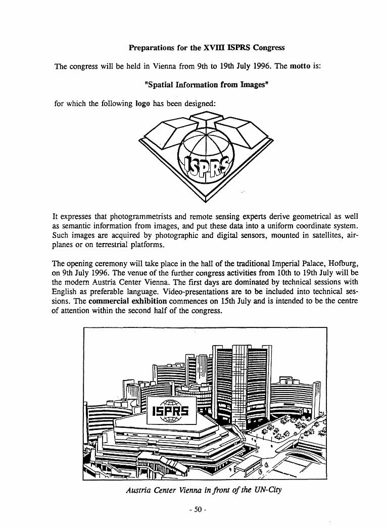
Preparations for tbe xvm ISPRS Congress
The congress will be held in Vienna from 9th to 19th July 1996. The motto is:
"Spatial Infonnation from Images"
for which the following logo has been designed:
It expresses that photogrammetrists and remote sensing experts derive geometrical as weIl as semantic information from images, and put these data into a uniform coordinate system. Such images are acquired by photographic and digital sensors, mounted in sateIlites, airplanes or on terrestrial platforms.
The opening ceremony will take place in the hall of the traditional Imperial Palace, Hofburg, on 9th July 1996. The venue of the further congress activities from 10th to 19th July will be tlte modem Austria Center Vienna. The first days are dominated by technical sessions with English as preferable language. Video-presentations are to be included into technical sessions. The commercial exhibition commences on 15th July and is intended to be the centre of attention within the second half of the congress.
~
15PR5 '<SHt>'
Austria Center Vienna in front 0/ the UN-City
- 50 -
Poster sessions should take place during the wh oIe period of the conference and will be held in a new way: At the beginning of a poster session the authors (approximately 8) are asked to give a concise introduction to their work in a lecture hall. Immediately afterwards there will be up to one hour time for thorough presentations and discussions in front of the posters; multilingual disputes are encouraged.
On 8th and 9th July half and full day tutorials are planned at the Vienna University of Technology. A questionnaire will be appended to the first announcement containing proposals for tutorials. The final selection depends on the interests of the intending participants.
Various technical tours and visits to private companies, public organisations, and scientific institutes in Austria will be organised.
There will also be offered a comprehensive social and cultural programme. Special attractions may be the weekend tours (13th/14th July) to Graz, Salzburg, Bratislava etc., and the post -conference excursions to Budapest, Prague etc.
Registration Fee: Student Acc. Person (1 USD is approx. 13 ATS (1993)) Senior (over 65)
By 31 Aug. 1995 4700 ATS 1800 ATS 1200 ATS
By 15 Jan. 1996 5200 ATS 2000 ATS 1400 ATS
After 15 Jan. 1996 5900 ATS 2200 ATS 1600 ATS
Daily admission will be 75 % off the listed fees.
Pre-Congress Schedule
1 April 1995 Call for Papers Call for pre-registration and housing and second announcement issued
15 October 1995 Deadline for submission of extended abstracts
15 February 1996 Latest date for Commission Presidents to inform authors of paper status
10 April 1996 Deadline for submission of papers for publication in the International Archives and closing for registration of authors
For Exhibitors only
30 June 1994 Deadline for lowest exhibition rate
28 February 1995 Deadline for reduced exhibition rate
31 January 1996 Deadline for final exhibition rate
- 51 -
REGIONAL MEMBER ACTIVITIES - 1993
ISPRS REGIONAL MEMBERS
AARS - Asian Association on Remote Sensing
EARSeL - European Association of Remote Sensing Laboratories
OACT - Organisation Africaine de Cartographie et Teledetection
OEEPE - Organisation Europeenne d'Etudes Photogrammetriques Experimentales
SELPER - Sociedad de Especialistas Latinoamericanos en Percepci6n Remota
ASIAN ASSOCIATION ON REMOTE SENSING (AARS) Submitted by: Shunji Murai, AARS General Secretary
S1RUCIURAL CHANGES OF REGIONAL MEMBER AARS SINCE LAST REPORT
General Secretary for 1994 - 1995: Shunji Murai has been re-elected.
Deputy General Secretary for 1994 - 1995: Suvit Vibulsresth has been re-elected.
AARS ACTIVITIES DURING 1993
Tbe 14th Asian Conference on Remote Sensing (ACRS) was held in Tehran, Iran between 12th and 17th, October 1993, with 478 participants including 66 foreign participants. In conjunction with the conference, two General Conferences were held for decision on the host of the next ACRS, election of General SecretarylDeputy General Secretary and others.
MAJOR ACCOMPUSHMENTS OF AARS DURING 1993
In cooperation with Japan Association of Remote Sensing (JARS), text book "Remote Sensing Note" of English version has been published. Free copy right will be provided with to AARS members who wish to translate into locallanguage.
Japanese version was published in advance.
Chinese version is now being printed.
Persian version will be published in 1994.
- 52 -
AARS NEWS
Tbe 15th ACRS will be held in Bangalore, India in 1994. Tbough the date has not yet been confirmed, November 24-30, 1994 is suggested.
A Working Group on 1 km Grid Land Cover Change Data Set has been established in AARS of which chairman is Dr. Ryutaro Tateishi, Chiba University, Japan.
RElATIONSHIPS WI1H 1HE ISPRS
Although AARS wishes to strengthen the relation with ISPRS in the regional activities, there cannot be found any structural way of contribution to ISPRS.
Photogrammetrists in Asian region have participated in ISPRS Congress, while most of remote sensing scientists in Asia and Pacific region used to participate in ACRS constantly and periodically.
It implies that ISPRS is not providing Asian remote sensing scientists with the more easy access, mainly because most of responsible organization or the representative of the ordinary members of ISPRS represents only photogrammetric community but not remote sensing community. In this regard, the regional member, particularly AARS wishes to join ISPRS with the same right and obligation as the ordinary member has, including voting right, in order to represent Asian region in the field of remote sensing.
EUROPEAN ASSOCIATION OF REMOTE SENSING LABORATORIES (EARSeL)
Submitted by: Dr. Roeland Allewijn, Secretary-General
S1RUCIURAL CHANGES OF REGIONAL MEMBER EARSeL SJNCE lAST REPORT
The EARSeL Bureau was renewed at the General Assembly, which took plaee in Dundee, U.K. on 30th June, 1993, as folIows:
Chairman: Prof. Dr. Gottfried Konecny University of Hannover Germany
Viee-chairman: Prof. Dr. Manfred Buchroithner University of Dresden Germany
Secretary-General: Dr. Roeland Allewijn Rijkswaterstaat, Delft The Netherlands
Treasurer: Dr. Robin Vaughan University of Dundee United Kingdom
18 new member laboratories were admitted during the General Assembly, bringing the membership to 275 full members and 3 observer members.
- 53 -
EARSeLNEWS
As weIl as the publication of Proeeedings of each of its meetings, EARSeL publishes a quarterly 28-page Newsletter, which acts as a forum for the dissemination of news coneerning remote sensing activities throughout Europe and elsewhere in the world, and also for the exchange of views among the EARSeL membership. Onee or twiee a year Special Issues of the Newsletter are published dealing with special events in the sphere of remote sensing, such as the first results of ERS-1 data studies, or large international symposia illustrating the state-of-the-art in the field of application studies.
RELATIONSHIPS WITH THE ISPRS
Relations are growing between the various Commissions of the ISPRS which have a remote sensing element in their studies and EARSeL, wh ich intends to explore possibilities for joint activities.
EARSeL Secretariat Mme. Madeleine Godefroy - B. 318 2, Avenue Rapp 75940 Paltis Cedex 07 - Franee Tel +(33.1) 45 56 73 60 Fax +(33.1) 45 56 75 61
EUROPEAN ORGANISATION FOR EXPERIMENTAL PHOTOGRAMMETRIC RESEARCH (OEEPE)
Submitted by: C. Paresi, OEEPE Secretary General
OEEPE ACTIVITIES DURING 1993
• Meetings:
Two meetings of the OEEPE Steering and Science Committees took place in 1993; one in The Hague (The Netherlands) in May, and the other one in Paris (France) in November. Several OEEPE Commission meetings were also held in 1993.
• Research Plan:
A new Research Plan has been adopted by the Steering Committee of the OEEPE in May 1993; the Research Plan presents the OEEPE research perspective and the OEEPE research programs and projects.
• Research projects:
The [ollowing research projects, wh ich started before 1993, have been continued:
DEMs for a GIS Crossing International Boundaries; Digital Landscape Model for Europe; OEEPE-test on Feature Based Segmentation; Data Standards (Quality Models); Large Scale Mapping; Updating of Complex Digital Topographie Databases; Geocoding of ERS-1 SAR Data.
The [ollowing research projects have been started in 1993:
GPS Supported Block Triangulation; Digital Aerial Triangulation; Accuracy of DTMs for Civil Engineering Purposes; Analysis of Photoscanners; DEM Quality; Feature Extraction from High Resolution Space Imagery; Automatie Generalization; Development of a Digital Camera.
• Cooperation With Other International Organizations:
Co-operation has been strengthen with the ISPRS, CERCO (Comite Europeen des Responsables de la Cartographie Officielle) and CEN (Comite Europeen de Normalisation), and has been started with AM/FM Europe, EARSeL (European Association of Remote Sensing Laboratories) and EUROGI (European Umbrella Organization for Geographical Information).
In particular, the research projects on Updating of Complex Digital Topographie Databases and on Data
- 54 -
Standards (Quality Models) are conducted in cooperation with CERCO and CEN respectively.
OEEPE MAJOR ACHIEVEMENTS IN 1993
• The OEEPE has celebrated its 40th anniversary in 1993.
• Under the Chairmanship of Prof. Dr. F. Ackermann, the OEEPE has become a very dynamic organization, has defined new research perspectives and plans, and has achieved more effective co-operation with several In terna tional Organisa tions.
• The following research projects have been successfully terminated in 1993:
OEEPE-Test on Feature Based Segmen ta tion,
GPS Supported Block Triangulation, and corresponding results will be published soon.
PLAN FOR FORTHCOMING ACTIVITIES
• 1994 will be a very busy year for the OEEPE with 14 research projects running in parallel, out of whieh 11 are expected to be terminated during that year.
• An OEEPE Workshop on Integrating Data for a Digital Landscape Model will be held on 21-22 March 1994 at the IFAG in Frankfurt (PRG).
• The OEEPE Statutes will be amended in 1994 to permit the organization to better adapt to external changes (user requirements/technology).
RELATIONSHIPS WI1H TIIE ISPRS
The relationships between the ISPRS and the OEEPE have become much more effective in terms of exchange of information, but also of co-operation between ISPRS Working Groups and OEEPE Commissions; further, the OEEPE will actively participate at the ISPRS Symposia in 1994; and a Regional Member Session has been reserved at the 18th ISPRS Congress in Vienna, 1996, with active participation of the OEEPE.
INTERSOCIETY ACTIVITIES - CIPA
~ATIONALCOMMmnEEFORARCHITE~PHOTOGRAMMETRY coMITE INTERNATIONAL DE PHOTOGRAMME1RIE ARCHITECfURALE (CIPA)
ANNUAL REPORT FOR 1993 Submitted by: Dr. lohn Badekas, President of CIPA
L CIP A Committee
The first part of this year was devoted to clarify the eomplications related to the appointment of the eommittee of CIP A aecording to new statutes.
Only the strong support of the seeretary general of ICOMOS Prof. Stovel and my constant effort into the matter were able to resolve this case.
Finally the Exeeutive Committee of the International Couneil on Monuments and Sites (ICOMOS) in its meeting in Sri Lanka in July 1993 approved the five members of ICOMOS.
TI. XV CIP A Symposium in Romania
Between 22-25.9.1993 the XV International Symposium of CIP A took place in Bueharest and Sinaia, Romania.
The Symposium was more successful than was expeeted as can be judged by the detailed report kindly prepared by Prof. Waldhaeusl whieh follows this report.
IIL CIPA Committee Meeting
All the evenings of the XV Symposium in Sinaia have been devoted to meetings of CIP A Committee.
The main topics of the agenda were the following three:
a. Eleetion of the president and the seeretary b. Plans for the period 1994-1997 e. CIP A meetings
The first is well known to ISPRS Couneil since it has already approved my eleetion as president of CIP A
I must only add that Robin Letellier has been selected as Secretary of CIP A
In relation to our future plans we have decided:
- 55 -
1. To improve the international image of CIP A For this purpose an informative pamphlet will be published soon.
2. To Establish a new network of national delegates and correspondents.
3. To Explore the possibility of publishing a text on "Photogrammetry for Non Photogrammetrists".
4. To Support the work of working groups.
5. To Strengthen our relations with ICOMOS.
6. To Improve the eeonomics of CIP A
As for the future meetings no decision has been taken since the previous administration has not made any preparation on that. For all the above items, members of the committee have taken the responsibility for action.
N. ICOMOS - UNESCO Round Table in Paris
On October 8 and 9, 1993 an ICOMOS-UNESCO round table took pI ace in Paris to formulate action for preparations against abrupt destructions. Prof. P. Waldhaeusl and M. Carbonnel represented CIP A and presented some of its activities.
V. ICOMOS Advisory Committee Meeting
On December 2 and 3 the meetings of the Advisory committee of ICOMOS took place in Paris.
Since this meeting was the first after my presidency I feIt obliged to participate and although I have been invited only a few days be fore the meeting I have managed to go to Paris.
The Advisory Committee consists of: a. The executive Committee of ICOMOS b. The presidents of the International Committees c. The presidents of the National Committees of
ICOMOS
At the moment there are 78 countries having national committees and with the members of the other committees there were more than 100 people eligible 10
participate. Out of these there were 20-25 people and there were discussed several topics which are of interest for CIPA
Some of these are: 1. Tbe move of ICOMOS from Paris to Versailles.
2. Tbe organization of regional meetings of ICOMOS wh ich could be combined with so me activities of CIPA
3. The meetings of Bureau, Executive Committee and Advisory Committee which may give a possibility for combination with CIP A
Most important, however, were the contacts that I have made with the ICOMOS authorities which I ho pe will be very helpful for CIP A
I am in constant communication with Mrs. Joan Domicely, Vice President of ICOMOS responsible for the International Committees of ICOMOS.
Report on "The XV International Symposium for Architectural Photogrammetry of CIP Alt
in Bucharest and Sinaia, Romania 22-25 September 1993
Report prepared by Dr. Peter Waldhaeusel
Nineteen countries were represented by 70 attendees. There were not more because the invitations came a little la te and because there was a time overlap with important events such as the Photogrammetric Weeks in Stuttgart.
In 1993 CIP A lost two of its most active experts during the last year, Professor Franjo Braum, Honorary member of CIP A, Zagreb, Croatia, and Professor Wilfried Wester-Ebbinghaus, Braunschweig, Germany.
The technical part of the symposium was organized in four five-hour sessions. nie opening lectures dealt with the International CIP A Test Karlsplatz, Vienna, which serves to demonstrate that amateur photography, properly made according to some simple rules, may weH be used as a means for photogrammetric heritage recordings. Tbis would help to speed up the recording process world-wide and to finalize it within one generation. All of the 96 bundle block restitutions ended with final deviations smaIler than rmse=2 cm.
All together about thirty papers were presented. So me highlights among them showed another very encouraging aspect: There exists something like a young CIP A, a group of new fa ces , who not only presented new and valuable ideas but who really presented them properly with weIl prepared slides and overhead viewgraphs. Such a best presentation award merits Andre Streilein, Zürich, Switzerland, who showed that we might use also simple camcorders for architectural (digital) photo-grammetry. Maurice Carbonnell, France, demanded a resolution on the systematic application of photogrammetric recording with priority in seismic zones. In Venzone, Friuli, Italy,
- 56 -
a great part of the reconstructions was possible, only because of the photogrammetric records made in between two seismic events.
Jazef Jachimski et a1., Cracow, Po land, reported about successful developments: A digital Video Stereo Digitizer including measuring and correlation software. Sergio Dequal and his staff from the Polytecnico di Turino, Italy, added to the International CIP A Test Karlsplatz an integrative information system for architectural photogrammetry with such a data structure that "Click to neighboring facade" is possible. Petros Patias et colleagues, Thessaloniki, Greece, introduced the Digital Rectification software DIRECT which uses parallel straight lines and/or object control points for the plane rectification of digital images.
Tbe very best presentation was that of Klaus Hanke, Innsbruck, Austria, on the use of the Kodak Photo Compact disk which will become an important tool of every digital photogrammetrist. Edel Lundemo and Oddgeir Defsti, Trondheim, Norway, presented their new book: Photogrammetry tor Heritage Recording, an important contribution to the working program of CIP A who decided in Sinaia 10 work on a modern and actual basic textbook for non-photogrammetrists which includes simple rules for photographic recordings with calibrated as weIl as with non-calibrated cameras.
Tbe proceedings can be ordered in 1994 from: Dr. Nicolaie Zegheru Institute for Geodesy, Photogrammetry, Cartography
and Land Management (IGFCOT) Bul. Expozitiei 1 A, Sector 1 RO-79662 Bucuresti, Romania.
At the end the Symposium adopted the following resolution:
The Symposium, considering:
the slow progress of the recording of the architectural and archaeological heritage of the world.
recommends: the world-wide use of photogrammetric recording using either metric or non-metric cameras, as appropriate, and in order to ensure a high professional standard of results, the use and promotion of a set of simple and proper rules that will guarantee satisfactory restitutions and rectifications.
Before closing, the outgoing President of CIP A, Prof. Mario Fondelli, Florence, Italy, handed over the responsibility for CIP A to the newly elected President, Prof. John Badekas, Athens, Greece, who then reported about the main events within the CIP A Committee: The new Ordinary Members have been agreed on by the Councils of ICOMOS and ISPRS, respectively:
ICOMOS is represented by Antonio Almagro, Spain; Francisco Cocke, Mexico; Ross Dallas, U.K.; Abdelaziz Daoulatli, Tunisia; Robin Letellier, Canada, and the ex officio member, the Director of ICOROM, Rome, Italy, Marc Laenen.
ISPRS is represented by John Badekas, Greece; Antonio Cheli, Argentina; Jozef Jachimski, Poland; Peter Waldhaeusl, Austria, and the ex officio member, the President of ISPRS Commission V, John Fryer, Australia.
The ex officio members may send representatives. One ISPRS seat is open and one ICOMOS seat will be open from 1994 onwards. Applications are possible from countries not yet represented in the Committee. Candidates should contact President Badekas for further information.
The four Working Groups of CIP Aare:
WG.I "Control Information" Chairmen: Waldhaeusl, Peipe. The WG continued with the CIP A Test Karisplatz.
WG.II "Digital Image Processing" Chairmen: Streilein, Hanke. The WG will get more and more import-ance and should prepare practical advices for the use
- 57 -
of Video and Digital Images for the aims of CIPA
WG.III "Simple Photogrammetric Systems" Chairman: Almagro, Jachimski. The WG will work on the establishment of an international network of cooperating institutions.
WG.IV "Data Base Information Systems" Chairmen: Letellier, Fiedler. A very important WG, the work should be continued according to the results of the symposium in Quebec in 1992.
A new WG will be established for Archaeology and Photogrammetry. lnterested readers are welcome to join the Working Groups.
All inquiries may be directed from now on to the president of CIP A:
Prof. John Badekas National Technical University Laboratory of Photogrammetry 9 IrDen Polytechniou Street GR-15773 Zografos, Greece Telephone + 30 1 770 8650, Fax +30 1 770 8550
or to the Secretary of CIP A: Robin Letellier Heritage Recording and Technical Data Service Architectural and Engineering Services Canadian Parks Service 10 Wellington Street, Hull Quebec KIA OH3, Canada Telephone: + 1-819-997-0146, Fax: + 1-819-997-6252.
The President invited all Members of ISPRS and ICOMOS to nominate National Delegates which CIP A will approve according to the new statutes. The National Delegates are supposed 10 form a close link between the CIP A, and 10 report 10 CIP A about the progress made in recording and photogrammetry within the countries. At each CIP A Symposium there will be from now on a special meeting of the National Delegates.
This years CIP A excursion lead to the old Kronstadt, one of the centers of the German minority population, to Prejmer, a rural fortified medieval village, and to the castle of Bran. It is not yet known, where the next CIP A Symposium will be. The national Societies are invited 10 submit proposals to the CIP A President. A more detailed report will be printed in the ISPRS Journal Photogrammetry anti Remote Sensing.
ISPRS PUBLICATIONS Lawrence W. Fritz, ISPRS Secretary General
The publications of ISPRS are in four categories:
1. International Archives
The In.temati.onal Archives o[ Photogrammetry and Remote Sensing contain the proceedings and the scientific and technical presentations of each Congress, edited and distributed by the Member organization responsible for the Congress. The scientific and technical presentations at Technical Commission Symposia are published by each of the Commission sponsoring Members, also as volumes of the Archives.
2 Official Journal
The ISPRS JoumoJ of Photogrammetry and Remote Sensillg is the official publication of the Society. It contains scientific and technical articles and reviews in the field of photogrammetry and remote sensing. It also reports on Congresses, Symposia and other activities of the ISPRS and as such, endeavors to be a primary channel of communication for specialists in all countries working in the many disciplines applying photogrammetry and remote sensing.
The ISPRS Journal is published by Elsevier Science Publishers and is issued six times per year.
3. Activities and Members of ISPRS
The ISPRS Organization and Programs (Silver Book) is published every four years. It contains: (1) Abrief summary of the Society his tory, objectives, members, awards, finances and structure; (2) Officers, activities, Commissions and Working Groups, Terms of Reference and planned events; (3) Society Statutes, Bylaws, Guidelines and Awards.
The ISPRS Member List (Blue Book) is published annually. It contains complete up-to-date addresses and communication numbers of each member organization (Ordinary Member), its officers and Commission Correspondents, and the officers, Regional Members, Sustaining Members and Honorary Members of the Society.
4. Special circulars and announcements
The ISPRS Brochure is a trifold published periodically and contains abrief description of the Society objectives, members and activities.
Special circulars, announcements and Working Group newsletters are produced and distributed by the ISPRS Technical Commissions to provide information on Congresses, Symposia and other activities of ISPRS.
THE /NTERNATIONALARCHIVES OF PHOTOGRAMMETRY AND REMOTE SENS/NG
Originally published in 1909, theInternationalArchives o[ Photogrammetry and Remote Sensing are now published every two years, that is, a volume for the quadrennial Congress and a volume for the midCongress Symposia. The Congress volumes contain the Proceedings and the technical presentations of each Congress. They are published in multiple books (Parts) and are edited and distributed by the national ISPRS Member organization responsible for the Congress.
The scientific and technical presentations of each of the seven ISPRS Symposia, which are held quadrennially during the mid-Congress year, are published by the national Member organization responsible for each
.. 58-
Commission. The Symposia volume is published in seven books (Parts).
The 1992 Volume XXIX of the International Archives from the XVII ISPRS Congress held in Washington, DC is published in 9 books:
Volume XXIX, Part A, published in hardcover, contains the Congress Proceedings.
Part B is composed of 7 books corresponding to the seven ISPRS Commissions.
"Complete Indexes of Authors, Coauthors and Keywords for Vol. XXIX, Part B -All Commissions"
The 1992 Archives (ISSN 0256-1840) are available from the:
American Society for Photogrammetry and Remote Sensing
5410 Grosvenor Lane, Suite 210 Bethesda, ~1D 20814~2160 U.S.A Phone: + 1-301-493-0290 Fax: + 1-301-493-0208
All seven Parts of the Archives (ISSN 0256-1840) from the 1994 Mid-Congress Symposia will be available from:
RICS Books Surveyor Court Westwood Way Coventrj CV4 BJE United Kingdom Phone: +44-71-222-7000 Fax: +44-71-334-3800
ISPRS JOURNAL OF PHOTOGRAMMETRY AND REMOTE SENSING
(Ib.e Official Publication of the International Society for Photogrammetry and Remote Sensing)
Annual Report to ISPRS Council Editor-in-Chief, David A. Tait
This has been a milestone year for the ISPRS Journal. It has been the first tull year under the new contract between ISPRS and Elsevier Science Publishers; the first year in the new format and layout; and the first year in which all four seetions have been fully operational; thus completing the transformation planned and started by the previous editor, Professor J. Hothmer.
Interest in the Journal has been maintained in terms of subscribers at a time when libraries and individuals are under increasing financial press ure. Steps are being taken to widen the subscriber base and Council has acted to increase the circulation of the Journal to ISPRS Members and Working Group Chairmen.
During the last 12 months, there have been 87 contributors from 21 different countries, refleeting the truly international nature of the Journal. The 21 scientific papers, 8 reviews and 24 reports have covered most aspects of our subjeet area. The concept of Theme Issues has been established and more single topie issues are planned.
The most profound change has been in the nature and content of the News Section, which now more efficiently strives to publicize and promote the work of ISPRS and, together with the information distributed regularly by the Secretary General, aims to keep members informed of developments within the Society.
- 59 -
The Council of ISPRS has been very supportive of the Journal in 1993. The Editors seek the active support of the wider membership of ISPRS in their attempts to make the ISPRS Journal a showcase for the Society and one whieh demonstrates to the Society and the wider scientifie community the important work being undertaken by the Society.
Scientifie and teehnical manuseripts in triplicate may be submitted directly to:
David A Tait Editor-in-Chief, ISPRS Journal Dept. of Geography and Topographie Seience University of Glasgow Glasgow G12 8QQ, U.K. Tel: +44-41-339 8855 x4783 Fax: +44-41-3304894
Subscriptions to the ISPRS Journal Jor Photogrammetry and Remote Sensing (ISSN 0924-2716) may be entered with subseription agents or direetly with:
Elsevier Science Publishers Attn: Jenny Henzen P.O. Box 1930 1000 BX Amsterdam The Netherlands Fax: +31-20-586-2696 Tel: +31-20-586-2911

ISPRS AWARDS AND STATE OF AFFAIRS Submitted by: Prof Kenner! Torlegard, ISPRS 1st Vice President
Prof lohn Trinder, ISPRS Treasurer
ISPRS AWARDS
Tbe International Society for Photogrammetry and Remote Sensing recognizes individual accomplishment in photogrammetry and remote sensing by six sponsored awards which are presented at the quadrennial Congresses of ISPRS.
Tbe Brock Gold Medal Award, sponsored by the the American Society for Photogrammetry and Remote Sensing, is presented for an outstanding contribution to the evolution of photogrammetric theory, instrumentation, or practice. Ordinary Members (national societies) of ISPRS are invited to recommenq recipients of the Award. Recommendations shall be made by two individuals of different nationality and also different from the candidate. Recommendations shall reach the Secretary General of ISPRS, Lawrence Fritz, not later than November 1994.
Tbe Otto von Gruber Award, sponsored by the ITC Foundation, is presented to the author, not older than 40 years, of a significant paper on photogrammetry or an allied subject written in the four year period preceding the Congress. Tbe Award consists of a medal and a monetary grant. Applications with 3 copies of the paper shall reach the President of ISPRS, Shunji Murai, not later than December 1995.
Tbe Samuel Gamble Award, sponsored by the Canadian Institute of Geomatics, is presented to persons irrespective of nationality, for their contributions to the administration of the Society or to the organization of activities of the Society's Commissions. Recommendations for the Award shall reach the Secretary General of ISPRS, Lawrence Fritz, not later than February 1996.
Tbe Schwidefsky Medal, sponsored by the German Society for Photogrammetry and Remote Sensing, is presented to persons who have made significant contributions to photogrammetry and remote sensing, either through the medium of publication as author or editor, or in another form. Recommendations for the Medal shall reach the Secretary General of ISPRS, Lawrence Fritz, not later than February 1996.
Tbe Willem Schem1erhom Award, sponsored by the Netherlands' Society ofPhotogrammetry, is presented to
- 60-
a person who has most significantly contributed to the activities of a Working Group of the ISPRS du ring the past four year Congress period. Nominations for the Award shall reach the President of ISPRS, Shunji Murai, not later than February 1996.
Tbe Edouard Dolezal Award, sponsored by the Austrian Society of Surveying and Photogrammetry, is presented to a person from a developing or reform country, who has successfully contributed to development of applications of photogrammetry and remote sensing. Tbe Award is a grant to cover expenses for the participation in the Congress. Applications shall reach the President of ISPRS, Shunji Murai, not later than November 1995.
Tbe ISPRS also awards Prizes Jor Best Papers by Young Authörs, who are at most 35 years old and are the single author of a high quality paper presented to the Congress. Tbe Prizes are grants to make it possible for the winners to attend the Congress. Applications including the paper shall reach the President of ISPRS, Shunji Murai, not later than January 1996.
Regulations and rules of the five first awards are found in the International Archives of Photogrammetry and Remote Sensing, Vol XXIX, Part A, 1994 (Proceedings of the Washington Congress 1992), and also in the so called "Silver Book" of ISPRS Organization and Programs 1992-96. Rules for the Dolezal Award can be obtained from the ISPRS Congress Director, Karl Kraus, and information on Best Papers from the ISPRS President, Shunji Murai.
MEMBERSHIP
Tbe current membership of ISPRS is:
Ordinary Members 94 Regional Members 5 Sustaining Members 23 (including 2 new members)
Two new Sustaining Members have applied for membership in 1993, Euroimage (Category C) and National Remote Sensing Agency of India (Category A). Two Sustaining Members (Kucera and Aerodata) were deleted from the list for continued non-payment of dues.
Invoices for payment of 1993 subscriptions were distributed by the end of January 1993, and reminders were sent out in June. Some Members who had been in arrears for some time have now paid. However, by the end of November, 43% of Ordinary Members, 40% of Regional Members and 26% of Sustaining Members have still not paid their 1993 subscriptions. The total amount owing for 1993 is Swf 19,767.75 or 24.5% of the expected income from subscriptions. There is also a significant number of Members who have not paid their subscriptions for previous years.
The Financial Commission at its meeting in May 1993, in Bonn Germany, recommended that the budget for fiscal year 1993-1994 should reflect the expectation that some members will not be able to pay their subscriptions. Therefore an amount of Swf 8,000 for non-payment of fees was included in the budget. This amount has clearly underestimated the true position with respect to the ability of members to pay their subscriptions.
Reasons for non-payment can be attributed to a number of causes, including the difficulty experienced by so me members in obtaining the overseas currencies required for the payment of the subscriptions. The major restructuring of governments in Eastern Europe, originaIly led to a number of new members in 1992. However, many of these members have experienced difficulties in paying their subscriptions and have
- 61 -
therefore contributed to the increase in the number of unfinancial members. Council is exploring ways by which these outstanding subscriptions can be paid.
SUSTAINING MEMBERSHIP DRIVE
Council at its meeting in October 1993, recognized that the number of Sustaining Members in ISPRS is very low, particularly considering the size and international character of the Society. Sustaining Members contribute to the Society financially and as weIl, they represent the important commercial sector of the industry of photogrammetry, remote sensing and GIS. It is important that the Society is weIl represented by this sector. Council therefore decided to undertake a drive, beginning in 1994, to substantially increase its number of Sustaining Members. It is hoped that members will cooperate with the Council to derive maximum benefit from this campaign.
FINANCIAL STA1US
Income for ISPRS is derived from subscriptions and from its investments. Despite the fact that there is a significant number of unfinancial members of ISPRS in 1993, the Society's investments in Swiss currency bonds have enabled it to remain in a very sound financial position. The accounts of the Society were audited in May 1993 by the Financial Commission and found to be correct and in good order.
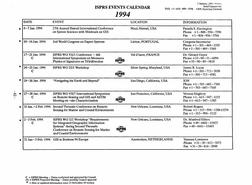
,..
,..
,..
,..
0\ ,.. N
,..
,..
,..
ISPRS EVENTS CALENDAR FAX: +1-610-889-3296
1 January 1994 'ii~N;(jll Send Updares to:
LWF, Secretary General
DATE EVENT
4-7 Jan. 1994 27th Annual Hawaü International Conferenee on System Scienees with Minitraek on GIS
10-14Jan.1994 2nd World Congress on Expert Systems
17-21 Jan. 1994 ISPRS WG VII/I Conferenee - 6th C International Symposium on Measures
Physies et Signatures en Teledeteetion
24-25 Jan. 1994 ISPRS WG HI/l Workshop C
24-26 Jan. 1994 "N avigating the Earth and Beyond"
27 - 28 J an. 1994 ISPRS WG VII/7 International Symposium C on Remote Sensing and GIS and ASTM
Meeting on -site Charaeterization
31 Jan.-2 Feb.1994 Seeond Thematie Conferenee on Remote Sensing for Marine and Coastal Environments
2 - 3 Feb. 1994 ISPRS WG II/2 Workshop "Requirements C for Integrated Geographie Information
Systems" during Second Thematic Conferenee on Remote Sensing for Marine and Coastal Environments
31 Jan-3 Feb. 1994 GIS in Business 94 Europe
----
C = ISPRS Meeting - Dates confrrmed and approved bJ. Council (1) = ISPRS Proposed Meeting - Dates pending Council approval
111 = New or updated information since 15 November 93 version
1994 LOCATION INFORMATION
Maui, Hawaii, USA Pamela S. Harrington Phone +1-808-956-7396 Fax +1-808-956-3766
Lisbon, PORTUGAL Congress Seeretariat Phone + 1-301-469-3355 Fax +1-301-469-3360
Val d'Isere, FRANCE Dr. Gerard Guyot ~ Phone +33-90-31-6094
15PR5 Fax +33-90-89-9810 '<f1iW
Silver Spring, Maryland, USA James R. Lueas ~ Phone + 1-301-713 - 2650
15PR5 Fax + 1-301-713 -4581 '<f1iW
San Diego, California, USA ION Phone +1-703-683-7101 Fax +1-703-683-7105
San Franciseo, California, USA Vernon Singhroy ~ Phone +1-613-947-1215
15PR5 Fax +1-613-947-1385 '<f1iW
New Orleans, Louisiana, USA Robert Rogers Phone + 1-313 - 994 -1200 x3234 Fax +1-313-994-5123
New Orleans, Louisiana, USA Dr. Manfred Ehlers Phone +49-4441-15423
~
15PR5 Fax +49-4441-15445
~
Amsterdam, NETHERLANDS Vanessa Lawrenee Phone +31-20-612-5073 Fax +31-20-616-3848
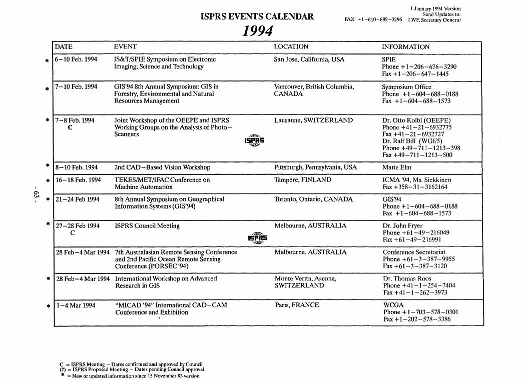
*
*
*
*
* 0\
w *
'"
'"
'"
ISPRS EVENTS CALENDAR FAX: + 1-610-889-3296
1 J anuary 1994 Version Send Updates to:
LWF, Secretary General
DATE EVENT
6-10 Feb. 1994 IS&T/SPIE Symposium on Electronic Imaging; Science and Thchnology
7 -10 Feb. 1994 GIS'94 8th Annual Symposium: GIS in Forestry, Environmental and Natural Resources Management
7-8 Feb. 1994 Joint Workshop of the OEEPE and ISPRS C Working Groups on the Analysis of Photo-
Scanners
8-10 Feb. 1994 2nd CAD-Based Vision Workshop
16-18 Feb. 1994 TEKES/MET/lFAC Conference on Machine Automation
21-24 Feb 1994 8th Annual Symposium on Geographical Information Systems (GIS'94)
27 - 28 Feb 1994 ISPRS Council Meeting C
28 Feb-4 Mar 1994 7th Australasian Remote Sensing Conference and 2nd Pacific Ocean Remote Sensing Conference (PORSEC (94)
28 Feb-4 Mar 1994 International Workshop on Advanced Research in GIS
1-4Mar 1994 "MICAD '94" International CAD-CAM Conference and Exhibition ..
----
C = ISPRS Meeting - Dates confmned and approved by eouncil (1) = ISPRS Proposed Meeting - Dates pending Council approval
111 = New or up<lated information since 15 November 93 version
1994 LOCATION INFORMATION
San J ose, California, USA SPIE Phone + 1-206-676-3290 Fax + 1-206-647-1445
Vancouver, British Columbia, Symposium Office CANADA Phone +1-604-688-0188
Fax +1-604-688-1573
Lausanne, SWITZERLAND Dr. OUo Kolbl (OEEPE) Phone +41-21-6932775
~ Fax +41-21-6932727 15PR5 Dr. Ralf Bill (WGI/5)
'<SlilitY Phone +49-711-1213-398 Fax +49-711-1213-500
Pittsburgh, Pennsylvania, USA Marie Elm
Tampere, FINLAND ICMA '94, Ms. Siekkinen Fax +358-31-3162164
Toronto, Ontario, CANADA GIS'94 Phone + 1-604-688-0188 Fax +1-604-688-1573
Melbourne, AUSTRALIA Dr. John Fryer ~ Phone +61-49-216049
15PR5 Fax +61-49-216991 './:S1i/iP'
Melbourne, AUSTRALIA Conference Secretariat Phone +61-3-387-9955 Fax +61-3-387-3120
Monte Verita, Ascona, Dr. Thomas Roos SWITZERLAND Phone +41-1-254-7404
Fax +41-1-262-3973
Paris, FRANCE WCGA Phone + 1-703 - 578 - 0301 Fax + 1-202-578-3386
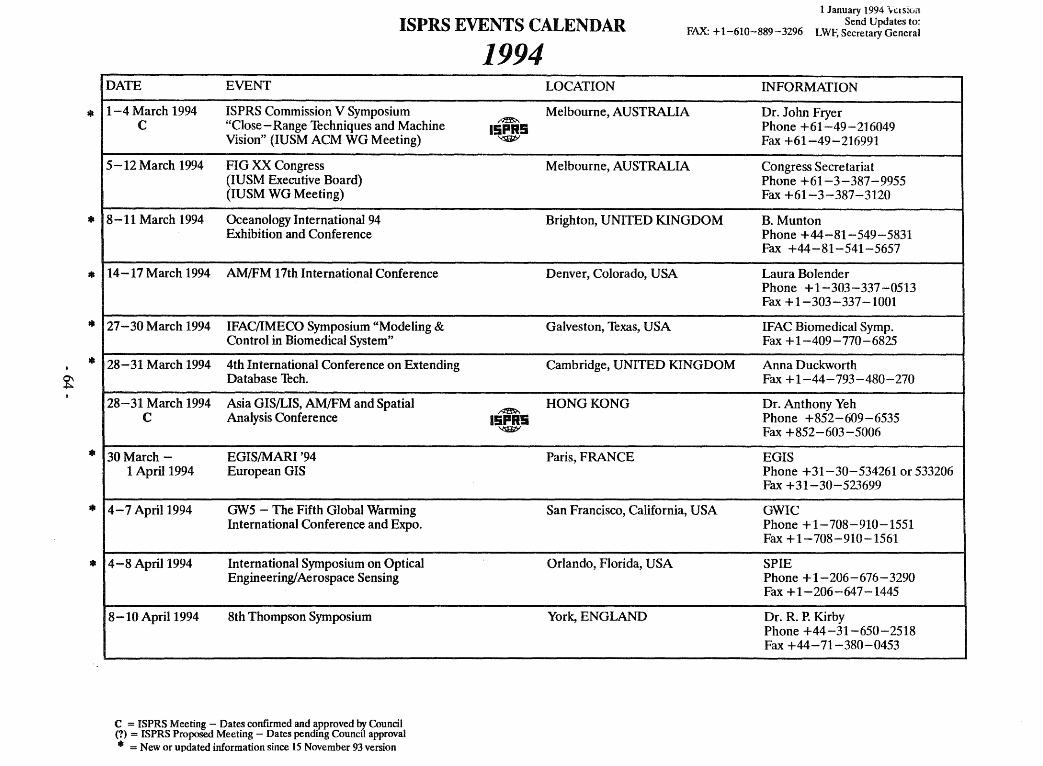
*
111
111
111
111
~
111
*
111
ISPRS EVENTS CALENDAR FAX: + 1-610-889 - 3296
1 January 1994 \e.\S:ün Send Updates to:
LWF, Secretary General
DATE EVENT
1-4 March 1994 ISPRS Commission V Symposium C "Close - Range lechniques and Machine
Vision" (IUSM ACM WG Meeting)
5 -12 March 1994 FIG XX Congress (IUSM Executive Board) (lU SM WG Meeting)
8-11 March 1994 Oceanology International 94 Exhibition and Conference
14-17 March 1994 AM/FM 17th International Conference
27 - 30 March 1994 IFAC/IMECO Symposium "Modeling & Control in Biomedical System"
28-31 March 1994 4th International Conference on Extending Oatabase lech.
28-31 March 1994 Asia GIS/LIS, AM/FM and Spatial C Analysis Conference
30 March - EGIS/MARI '94 1 April 1994 European GIS
4-7 April 1994 GW5 - The Fifth Global Warming International Conference and Expo.
4-8 April 1994 International Symposium on Optical Engineering! Aerospace Sensing
8-10 April 1994 8th Thompson Symposium
-~
C = ISPRS Meeting - Dates confrrmed and approved bJ. Council (1) = ISPRS Proposed Meeting - Dates pending Councd approval • = New or updated information since 15 November 93 version
1994
~
15PR5 ~
~
15PR5 ~
LOCATION INFORMATION
Melbourne, AUSTRALIA Dr. John Fryer Phone +61-49-216049 Fax +61-49-216991
Melbourne, AUSTRALIA Congress Secretariat Phone +61-3-387-9955 Fax +61-3-387-3120
Brighton, UNITED KINGDOM B. Munton Phone +44-81-549-5831 Fax +44-81-541-5657
Denver, CoIorado, USA Laura Bolender Phone + 1-303-337 -0513 Fax +1-303-337-1001
Galveston, Texas, USA IFAC Biomedical Symp. Fax +1-409-770-6825
Cambridge, UNITEO KING DOM Anna Duckworth Fax +1-44-793-480-270
HONGKONG Or. Anthony Yeh Phone +852-609-6535 Fax +852-603-5006
Paris, FRANCE EGIS Phone +31-30-534261 or 533206 Fax +31-30-523699
San Francisco, California, USA GWIC Phone +1-708-910-1551 Fax + 1-708-910-1561
OrJando, F1orida, USA SPIE Phone +1-206-676-3290 Fax +1-206-647-1445
York, ENGLAND Or. R. P. Kirby Phone +44-31-650-2518 Fax +44-71-380-0453
-- --
i
i
I
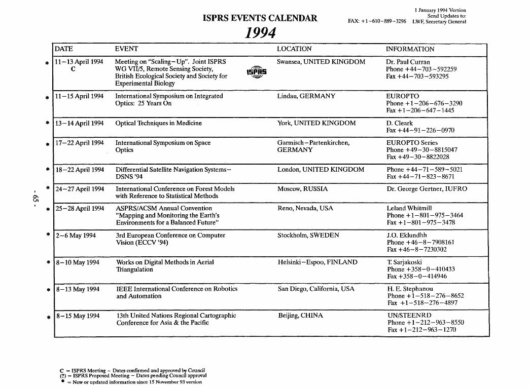
0\ Vl
,..
,..
,..
,..
,..
,..
,..
,..
=11
,..
,..
ISPRS EVENTS CALENDAR FAX: + 1-610-889-3296
1 January 1994 Version Send Updates to:
LWF, Secretary General
I DATE EVENT
11-13 April 1994 Meeting on "Scaling - Up". Joint ISPRS C WG VII/5, Remote Sensing Society,
British Ecological Society and Society for Experimental Biology
11-15 April 1994 International Symposium on Integrated Optics: 25 Years On
13-14 April 1994 Optical Techniques in Medicine
17 - 22 April 1994 International Symposium on Space Optics
18-22 April 1994 Differential Satellite Navigation Systems-DSNS'94
24-27 April 1994 International Conference on Forest Models with Reference to Statistical Methods
25-28 April 1994 ASPRS/ ACSM Annual Convention "Mapping and Monitoring the Earth' s Environments for a Balanced Future"
2-6 May 1994 3rd European Conference on Computer Vision (ECCV (94)
8-10 May 1994 Works on Digital Methods in Aerial 1liangulation
8-13 May 1994 IEEE International Conference on Robotics and Automation
8-15 May 1994 13th United Nations Regional Cartographic Conference for Asia & the Pacific
c = ISPRS Meeting - Dates conftrmed and approved by Council (?) = ISPRS Proposed Meeting - Dates pending Council approval • = New or updated information since 15 November 93 version
1994 LOCATION INFORMATION
Swansea, UNITED KINGDOM Dr. Paul Curran ~ Phone +44-703-592259 15PI5 ~ Fax +44-703-593295
Lindau, GERMANY EUROPTO Phone + 1-206-676-3290 Fax +1-206-647-1445
York, UNITED KING DOM D. Cleark Fax +44-91-226-0970
Gannisch - Partenkirchen, EUROPTO Series GERMANY Phone +49-30-8815047
Fax +49-30-8822028
London, UNITED KINGDOM Phone +44-71-589-5021 Fax +44-71-823-8671
Moscow, RUSSIA Dr. George Gertner, IUFRO
Reno, Nevada, USA Leland Whitmill Phone +1-801-975-3464 Fax + 1-801-975-3478
Stockholm, SWEDEN J.O. Eklundhh Phone +46-8-7908161 Fax +46-8-7230302
Helsinki - Espoo, FINLAND T. Sarjakoski Phone +358-0-410433 Fax +358-0-414946
San Diego, California, USA H. E. Stephanou Phone +1-518-276-8652 Fax +1-518-276-4897
Beijing, CHINA UN/STEENRD Phone + 1-212-963-8550 Fax + 1-212-963-1270
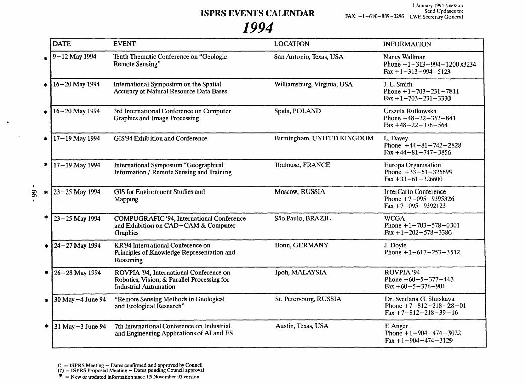
111
111
*
111
*
~ 111
*
111
*
111
111
ISPRS EVENTS CALENDAR FAX: + 1-610-889-3296
1 January 1994 Vers!on Send Updates to:
LWF, Secretary General
1994 DATE EVENT
9-12 May 1994 Tenth Thematic Conference on "Geologie Remote Sensing"
16-20 May 1994 International Symposium on the Spatial Accuracy of Natural Resource Data Bases
16-20 May 1994 3rd International Conference on Computer Graphics and Image Processing
17-19 May 1994 GIS'94 Exhibition and Conference
17-19 May 1994 International Symposium "Geographical Information / Remote Sensing and 1taining
23 - 25 May 1994 GIS for Environment Studies and Mapping
23-25 May 1994 COMPUGRAFIC '94, International Conference and Exhibition on CAD-CAM & Computer Graphics
24-27 May 1994 KR'94 International Conference on Principles of Knowledge Representation and Reasoning
26-28 May 1994 ROVPIA '94, International Conference on Robotics, Vision, & Parallel Processing for Industrial Automation
30 May-4 June 94 "Remote Sensing Methods in Geological and Ecological Research"
31 May-3 June 94 7th International Conference on Industrial and Engineering Applications of AI and ES
---
C = ISPRS Meeting - Dates confrrmed and approved by Council (1) = ISPRS Proposed Meeting - Dates pending Council approval • = New or updated information since 15 November 93 version
LOCATION INFORMATION
San Antonio, Texas, USA N ancy Wallman Phone + 1-313 - 994 -1200 x3234 Fax + 1-313-994-5123
Williamsburg, Virginia, USA J. L. Smith Phone +1-703-231-7811 Fax + 1-703-231-3330
Spala, POLAND Urszula Rutkowska Phone +48-22-362-841 Fax +48-22-376-564
Birmingham, UNITED KINGDOM L. Davey Phone +44-81-742-2828 Fax +44-81-747-3856
Toulouse, FRANCE Europa Organisation Phone +33-61-326699 Fax +33-61-326600
Moscow, RUSSIA InterCarto Conference Phone +7-095-9395326 Fax +7-095-9392123
Sao Paulo, BRAZIL WCGA Phone + 1-703 - 578 - 0301 Fax + 1-202-578-3386
Bonn, GERMANY J. Doyle Phone + 1-617-253-3512
Ipoh, MALAYSIA ROVPIA'94 Phone +60-5-377-443 Fax +60-5-376-901
St. Petersburg, RUSSIA Dr. Svetlana G. Slutskaya Phone +7-812-218-28-01 Fax +7-812-218-39-16
Austin, Texas, USA F. Anger Phone + 1-904-474-3022 Fax + 1-904-474-3129
~-
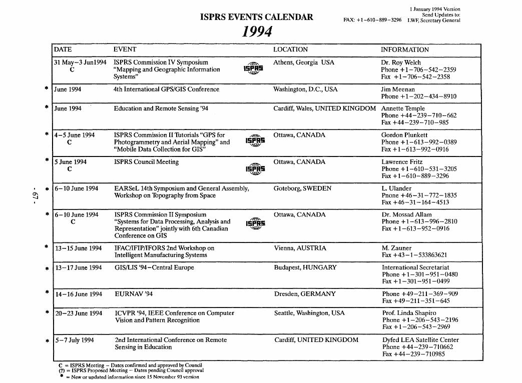
0\ -J
111
111
111
111
111
111
111
111
111
111
111
ISPRSEVENTSCALENDAR FAX: + 1-610-889-3296
1 January 1994 Version Send Updates to:
LWF, Secretary General
1994 DATE EVENT
31 May-3 Jun1994 ISPRS Commission IV Symposium ~
C "Mapping and Geographie Information 15P95 Systems"
'<sIJit;/
June 1994 4th International GPS/GIS Conferenee
June 1994 Edueation and Remote Sensing '94
4-5 June 1994 ISPRS Commission II Thtorials "GPS for ~
C Photogrammetry and Aerial Mapping" and 15PR5 ~
"Mobile Data Colleetion for GIS"
5 June 1994 ISPRS Couneil Meeting ~
C 15PR5 ~
6-10 June 1994 EARSeL 14th Symposium and General Assembly, Workshop on Thpography from Spaee
6-10 June 1994 ISPRS Commission II Symposium C "Systems for Data Proeessing, Analysis and
Representation" jointly with 6th Canadian Conferenee on GIS
13-15 June 1994 IFAC/IFIP/IFORS 2nd Workshop on Intelligent Manufaeturing Systems
13-17 June 1994 GIS/LIS '94-Central Europe
14-16 June 1994 EURNAV'94
20-23 June 1994 ICVPR '94, IEEE Conferenee on Computer Vision and Pattern Reeognition
5-7 July 1994 2nd International Conferenee on Remote Sensing in Edueation
---- --_ .. __ .. -
C = ISPRS Meeting - Dates confirmed and approved by Council (1) = ISPRS Proposed Meeting - Dates pending Council approval • = New or updated information since 15 November 93 version
~
15PR5 '<sIJit;/
LOCATION INFORMATION
Athens, Georgia USA Dr. Roy WeIch Phone + 1-706-542-2359 Fax +1-706-542-2358
Washington, D.C., USA JimMeenan Phone + 1-202-434-8910
Cardiff, Wales, UNITED KINGDOM Annette Temple Phone +44-239-710-662 Fax +44-239-710-985
Ottawa, CANADA Gordon Plunkett Phone + 1-613-992-0389 Fax + 1-613-992-0916
Ottawa, CANADA Lawrenee Fritz Phone + 1-610-531-3205 Fax + 1-610-889-3296
Goteborg, SWEDEN L. Ulander Pnone +46-31-772-1835 Fax +46-31-164-4513
Ottawa, CANADA Dr. Mossad AIlam Phone +1-613-996-2810 Fax + 1-613-952-0916
Vienna, AUSTRIA M. Zauner Fax +43-1-533863621
Budapest, HUNGARY International Seeretariat Phone + 1-301-951-0480 Fax + 1-301-951-0499
Dresden, GERMANY Phone +49-211-369-909 Fax +49-211-351-645
Seattle, Washington, USA Prof. Linda Shapiro Phone + 1-206-543-2196 Fax + 1-206-543-2969
Cardiff, UNITED KINGDOM Dyfed LEA SateUite Center Phone +44-239-710662 Fax +44-239-710985
I
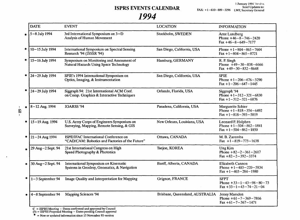
*
*
*
*
*
111
~
*
*
*
*
*
*
1 January 1994 "vel~inr.
ISPRS EVENTS CALENDAR Send Updates to: LWF, Secretary General FAX: +1-610-889-3296
1994 DATE EVENT
5-8 July 1994 3rd International Symposium on 3 - D Analysis of Human Movement
10-15 July 1994 International Symposium on Spectral Sensing Research '94 (ISSSR '94)
15-16 July 1994 Symposium on Monitoring and Assessment of Natural Hazards Using Space Technology
24-29 July 1994 SPIE's 1994 International Symposium on Optics, Imaging, & Instrumentation
24-29 J uly 1994 Siggraph 94: 21st International ACM Conf. on Comp. Graphics & Interactive Techniques
8-12 Aug. 1994 IGARSS'94
15 -19 Aug. 1994 U .S. Army Corps of Engineers Symposium on Surveying, Mapping, Remote Sensing, & GIS
21-24 Aug 1994 ISPE/IFAC International Conference on "CAD/CAM: Robotics and Factories of the Future"
29 Aug-2 Sept. 94 21st International Congress on High Speed Photography & Photonics
30 Aug-2 Sept. 94 International Symposium on Kinematic Systems in Geodesy, Geomatics, & Navigation
1-3 September 94 Image Quality and Interpretation for Mapping
4-8 September 94 Mapping Sciences '94
-
C = ISPRS Meeting - Dates confrrmed and approved bJ. Council (1) = ISPRS Proposed Meeting - Dates pendfug Counctl approval • = New or updated information since 15 November 93 version
LOCATION INFORMATION
Stockholm, SWEDEN Arne Lundberg Phone +46-8-746-2420 Fax +46-8-649-7177
San Diego, California, USA Phone + 1-804-865-7604 Fax + 1-804-865-8721
Hamburg, GERMANY R. P. Singh Phone +49-30-838-6666 Fax +49-30-832-8648
San Diego, California, USA SPIE Phone + 1-206-676-3290 Fax +1-206-647-1445
Orlando, Florida, USA Siggraph '94 Phone +1-312-321-6830 :
Fax + 1-312-321-6876
Pasadena, California, USA Marguerite Schier Phone + 1-818-354-6492 Fax +1-818-393-5019
N ew Orleans, Louisiana, USA Leonard P. Halphen Phone + 1-504-862-1841 Fax + 1-504-862-1850
Ottawa, CANADA M. B. Zaremba Fax +1-819-773-1638
Taejon, KOREA UngKim Phone +82-2-361-2617 Fax +82-2-392-3374
Banff, A1berta, CANADA Elizabeth Cannon Phone +1-403-220-5834 Fax + 1-403-284-1980
Grignon, FRANCE SFPT Phone +33-1-43-98-80-73 Fax +33-1-43-74-21-04
Brisbane, Queensland, AUSTRALIA J enny Marsden Phone +61-7-369-7866 Fax +61-7-367-1471 ~---_ .. __ .. _.- ----- -------------------
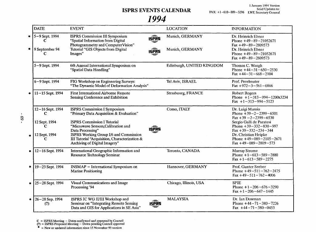
=11
=11
=11
$
=11
=11
=11
=11
=11
ISPRS EVENTS CALENDAR FAX: + 1-610-889-3296
1 J anuary 1994 Version Send Updates to:
LWF, Secretary General
1994 DATE EVENT
5-9 Sept. 1994 ISPRS Commission III Symposium ~
15PI5 C "Spatial Information from Digital ~
Photogrammetry and ComputerVision" 9 September 94 Thtorial "GIS Objects from Digital ~
15PR5 C Images" ~
5-9 Sept. 1994 6th Annual International Symposium on "Spatial Data Handling"
6-9 Sept. 1994 FIG Workshop on Engineering Surveys: "The Dynamic Model of Deformation Analysis"
11-15 Sept. 1994 First International Airborne Remote Sensing Conference and Exhibition
12-16 Sept. 1994 ISPRS Commission I Symposium C "Primary Data Acquisition & Evaluation"
12 Sept. 1994 ISPRS Commission I Thtorial C "Microwave Sensors,Calibration and
Data Processing" 12 Sept. 1994 ISPRS Working Group 1/6 and Commission
C TII Thtorial '~cquisition, Characterization & Archiving of Digital Imagery"
12-16 Sept. 1994 International Geographie Information and Resource Technology Seminar
19-23 Sept. 1994 INSMAP - International Symposium on Marine Positioning
25 - 28 Sept. 1994 Visual Communications and Image Processing '94
26-28 Sep.1994 ISPRS IC WG IIIIII Workshop and (?) Seminar on "Integrating Remote Sensing
Data and GIS for Applications in SE Asia"
C = ISPRS Meeting - Dates confrrmed and approved b.Y. Council (?) = ISPRS Proposed Meeting - Dates pending Council approval
111 = New or updated information since 15 November 93 version
~
15PR5 ~
~
15PI5 ~
LOCATION INFORMATION
Munieh, GERMANY Dr. Heinrich Ebner Phone +49-89-21052671 Fax +49-89-2809573
Munich, GERMANY Dr. Heinrich Ebner Phone +49-89-21052671 Fax +49-89-2809573
Edinburgh, UNITED KINGDOM Thomas C. Waugh Phone +44-31-650-2530 Fax +44-31-668-2104
Tel Aviv, ISRAEL Prof. Perelmuter Fax +972-3-561-0866
Strasbourg, FRANCE Robert Rogers Phone + 1-313-994-12000234 Fax +1-313-994-5123
Como,ITALY Dr. Luigi M ussio Phone +39-2-2399-6501 Fax +39 -2-2399-6530 Sergio Galli de Paratesi Phone +39-332-830-997 Fax +39-332-234-344 Dr. Christian Heipke Phone +49-089-2105-2671 Fax +49-089-2809-573
Toronto, CANADA Murray Strome Phone + 1-613-589-2880 Fax + 1-613-589-2275
Hannover, GERMANY Prof. Gunter Seeber Phone +49-511-762-2475 Fax +49-511-762-4006
Chicago, Illinois, USA SPIE Phone + 1-206-676-3290 Fax +1-206-647-1445
MALAYSIA Dr. lan Dowman Phone +44 -71-380-7226 Fax +44-71-380-0453
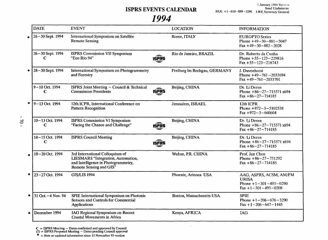
-J o
*
11&
*
*
*
*
*
ISPRS EVENTS CALENDAR FAX: +1-610-889-3296
1 January 1994 Ve,,;~~,''l Send Updates to:
LWF, Secretary General
DATE EVENT
26-30 Sept. 1994 International Symposium on SateHite Remote Sensing
26-30 Sept. 1994 ISPRS Commission VII Symposium C "Eco Rio 94"
28 - 30 Sept. 1994 International Symposium on Photogrammetry and Forestry
9-100et.1994 ISPRS Joint Meeting - Council & Thehnical C Commission Presidents
9-13 Oct. 1994 12th ICPR, International Conference on Pattern Reeognition
10-13 Oet. 1994 ISPRS Commission VI Symposium C "Facing the Chance and ChaUenge"
14-150ct.1994 ISPRS Council Meeting C
18-200et. 1994 3rd International ColJoquium of UESMARS "Integration, Automation, and Intelligence in Photogrammetry, Remote Sensing and GIS"
23 - 27 Oet. 1994 GIS/LIS 1994
31 Oet.-4 Nov. 94 SPIE International Symposium on Photonie Sensors and Controls for Commercial Applications
December 1994 lAG Regional Symposium on Recent Crustal Movements in Mrica
C = ISPRS Meeting - Dates confirmed and approved by Council (1) = ISPRS Proposed Meeting - Dates pending CounciJ approval 41 = New or updated information since 15 November 93 version
1994 LOCATION INFORMATION
Rome,ITALY EUROPTO Series Phone +49-30-881-5047 Fax +49-30-882-2028
~ Rio de Janeiro, BRAZIL Dr. Roberto da Cunha
15PI5 Phone +55-123-229816 '<Sli1ib' Fax +55-123-218743
Freiburg Im BreIsgau, GERMANY J. Duvenhorst Phone +49-761-2033694 Fax +49-761-2033701
~ Beijing, CHINA Dr. Li Deren 15PI5 Phone +86-27-715571 x694
'<Sli1ib' Fax +86-27-714185
J erusalem, ISRAEL 12th ICPR Phone +972-3-5102538 Fax +972-3 -660604
Beijing, CHINA Dr. Li Deren ~
15PI5 Phone +86-27-715571 x694 '<Sli1ib' Fax +86-27-714185
Beijing, CHINA Dr. Li Deren ~ Phone +86-27-715571 x694 15PI5 '<:!iiiIit>' Fax +86-27-714185
Wuhan, P.R. CHINA Prof. Jun Chen Phone +86-27-731292 Fax +86-27-714185
Phoenix, Arizona USA AAG, ASPRS, ACSM, AMIFM URISA Phone + 1-301-493-0290 Fax + 1-301-493-0208
Boston, Massachusetts USA SPIE Phone +1-206-676-3290 Fax +1-206-647-1445
Kenya, AFRICA lAG
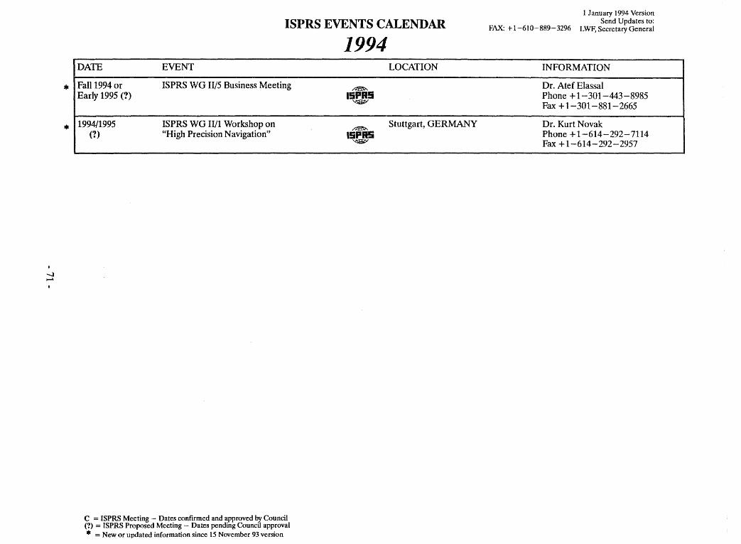
-.J ~
*
*
ISPRS EVENTS CALENDAR
DATE EVENT
Fall 1994 or ISPRS WO 11/5 Business Meeting Early 1995 (?)
1994/1995 ISPRS WO II/1 Workshop on (?) "High Precision Navigation"
c = ISPRS Meeting - Dates conftrmed and approved by Council (1) = ISPRS Proposed Meeting - Dates pending Council approval • = New or updated information since 15 November 93 version
1994 LOCATION
~
15PR5 '<SJiIitY
~ Stuttgart, OERMANY
15PR5 '<'iBif;>'
FAX: +1-610-889-3296
1 January 1994 Version Send Updates to:
LWF, Secretary General
INFORMATION
Dr. Atef Elassal Phone + 1-301-443-8985 Fax + 1-301-881-2665
Dr. Kurt Novak Phone +1-614-292-7114 Fax + 1-614-292-2957

...J N
111
111
ISPRS EVENTS CALENDAR
1995 DATE EVENT
Spring 1995 ISPRS WG IIIIII Conference on Digital ~
(?) Photogrammetric Systems 15PR5 ~
April 1995 ISPRS WG II/3 Meeting during: ~
(?) Cataloque Inter-Operability Workshop 15PR5 '<SliJit;'
21-26 May 1995 62nd FIG Permanent Committee Meeting
30 May-1 June ISPRS Joint Meeting - Council and Thchnical ~ 1995 Commission Presidents 15PR5
(?)
2-3 June 1995 ISPRS Council Meeting C
5-9 June 1995 ISPRS Commission I Workshop on C Multimedia GIS Data
8 June 1995 ISPRS WG III/4 Thtorial C on Spatial Data Analysis: Theory
& Algorithms
13-15 June 1995 GIS/LIS '95
29 June-1 Jul1995 IUSM Retreat - an ISPRS Officers (?)
2 -15 July 1995 IUGG Conference and XXI General C Assembly (with IUSM Council and
Exec. Board Meetings)
17-18 July 1995 ISPRS WG I/4 and WG I/6 Workshop C on "Recent Advances in Signal Evaluation"
------
C = ISPRS Meeting - Dates confirmed and approved b,y Council (?) = ISPRS Proposed Meeting - Dates pending Council approval • = New or updated information since 15 November 93 version
~
~
15PR5 '<SJiGt>'
~
15PR5 ~
~
15PR5 '<S1iJiiPI
~
15PR5 ~
~
15PR5 ~
LOCATION
USA
BerIin, GERMANY
Vienna, AUSTRIA
Vienna, AUSTRIA
Udine, ITALY
Central Europe
Boulder, Colorado, USA
Boulder, Colorado
Boulder, Colorado, USA
1 January 1994
FAX: +1-610-889-3296 Send Updates to:
LWF, Secretary General
INFORMATION
Dr. David McKeown Phone + 1-412-268-2626 Fax + 1-412-681-5739
Dr. Ekow Otoo Phone +1-613-788-2600 Fax +1-613-788-4334
FIG
Prof Karl Kraus Phone +43-1-58801-3811 Fax +43-1-505-6268
Prof Karl Kraus Phone +43-1-58801-3811 Fax +43-1-505-6268
Dr. Riccardo Galetto Phone +39-382-391-410 Fax +39-382-391-419 Prof. Fabio Crosilla Phone +39-432-504128 Fax +39-432-294928
Phone + 1-301-951-0480 Fax + 1-301-951-0499
IUSM, Secretariat Phone +1-613-995-4449 Fax + 1-613-995-0842
IAG Phone +1-202-462-6910 Ext. 238
Dr. John Curlander Phone + 1-303 -444-0094 Fax + 1-303-444-0470
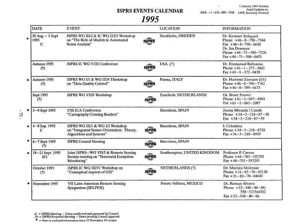
-l tN
111
111
111
111
111
111
111
ISPRSEVENTSCALENDAR FAX: +1-610-889-3296
1 January 1994 Version Send Updates to:
LWF, Secretary General
DATE EVENT
30 Aug - 1 Sept ISPRS WG III/2 & IC WG IIIIII Workshop 1995 on "The Role of Models in Automated
C Scene Analysis"
Autumn 1995 ISPRS IC WG V /III Conference (1)
Autumn 1995 ISPRS WG I/l & WG IH/4 Thinkshop (1) on "Data Quality Control"
Sept 1995 ISPRS WG VII/6 Workshop (1)
3-9 Sept 1995 17th ICA Conference "Cartography Crossing Borders"
4-8 Sep. 1995 ISPRS WG HI/l & WO I/2 Workshop C on "Integrated Sensor Orientation: Theory,
Algorithms and Systems"
6-7 Sept 1995 ISPRS Council Meeting (1)
18-21 Sept. 1995 Joint ISPRS-WO VII/5 & Remote Sensing (C) Society meeting on "Terrestrial Ecosystem
Monitoring"
October 1995 ISPRS IC WG III/IV Workshop on (1) "Conceptual Aspects of GIS"
November 1995 VII Latin American Remote Sensing Symposium (SELPER)
_ .. _----------------
C = ISPRS Meeting - Dates confrrmed and approved by Council (1) = ISPRS Proposed Meeting - Dates pending Councd approval
111 = New or updated information since 15 November 93 version
1995 LOCATION INFORMATION
~ Stockholm, SWEDEN Dr. Kennert ThrIegard
ISPR! Phone +46-8-790-7344 ~ Fax +46-8-790-6610
Dr. Ian Dowman Phone +44-71-380-7226 Fax +44-71-380-0453
~ USA (?) Dr. Emmanual Baltsavias ISPR5 Phone +41-1-377-3042 ~
Fax +41-1-372-0438
nzm... Parma, ITALY Dr. Hartmut Ziemann (I/1) ISPR5 Phone +46-8-790-7182 ~ Fax +46-8-789-6672
Enschede, NETHERLANDS Dr. Bruce Forster ~
15PR5 Phone +61-2-697-4964 'i!JiI1>' Fax +61-2-662-2087
Barcelona, SPAIN J aume Miranda I Canals Phone +34-3-218-87-58 Fax +34-3-218-87-59
~ Barcelona, SPAIN I. Colomina
15PR5 Phone +34-3-218-8758 ~ Fax +34-3-218-8959
~ Barcelona, SPAIN 15PR5
'i!JiI1>'
~ Southampton, UNITED KINGDOM Professor P. Curran
ISPR5 Phone +44-703-592295 ~ Fax +44-703-593295
~ NETHERLANDS (?) Dr. Martien Molenaar ISPR5 Phone +31-83-70-82130 ~ Fax +31-83-70-84643
Puerto Vallarta, MEXICO Dr. Roman Alvarez Phone +52-548-40-86/
550-5215x4302 Fax +52-548-40-86
------- ----------
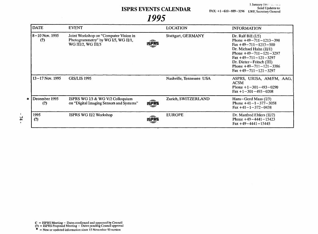
-..J .a:::..
*
ISPRS EVENTS CALENDAR FAX: + 1-610-889-3296
1 January IIj~; ,t
Send Updates to: LWF, Secretary General
DATE EVENT
8-10 Nov. 1995 Joint Workshop on "Computer Vision in (1) Photogrammetry" by WG 1/5, WG 11/1,
WG IIl/2, WG Ill/3
13-17 Nov. 1995 GIS/LIS 1995
December 1995 ISPRS WG 1/3 & WG V /2 Colloquium (1) on "Digital Imaging Sensors and Systems"
1995 ISPRS WG 11/2 Workshop (1)
C = ISPRS Meeting - Dates confirmed and approved bJ. Council (1) = ISPRS Proposed Meeting - Dates pending Council approval • = New or updated information since 15 November 93 version
1995
~
15PR5 ~
~
15PR5 ~
~
15PR5 ~.
LOCATION INFORMATION
Stuttgart, GERMANY Dr. Ralf Bill (I/5) Phone +49-711-1213-398 Fax +49-711-1213-500 Dr. Michael Hahn (lI/I) Phone +49-711-121-3297 Fax +49-711-121-3297 Dr. Dieter-Fritsch (lU) Phone +49-711-121-3386 Fax +49-711-121-3297
Nashville, Tennessee USA ASPRS, URISA, AM/FM, AAG, ACSM Phone + 1-301-493 -0290 Fax + 1-301-493-0208
Zurich, SWITZERLAND Hans-Gerd Maas (1/3) Phone +41-1-377-3058 Fax +41-1-372-0438
EUROPE Dr. Manfred Ehlers (Il/2) Phone +49-4441-15423 Fax +49-4441-15445
-....J Vl
ISPRS EVENTS CALENDAR FAX: +1-610-889-3296
1 January 1994 Version Send Updates to:
LWF, Secretary General
DATE EVENT
15-17 Jan. 1996 ISPRS Joint Meeting - Council and Technical (1) Commission Presidents
18 -19 J an. 1996 ISPRS CounciJ Meeting (1)
1996, prob. March 63rd FIG Permanent Committee Meeting
April 1996 ISPRS WG Hf3 Meeting during: (1) Cataloque Inter-Operability Workshop
6-8 July 1996 ISPRS Council Meeting C
9-19 July 1996 18th ISPRS Congress C
C = ISPRS Meeting - Dates confirmed and approved bJ. Council (?) = ISPRS Proposed Meeting - Dates pending Council approval • = New or updated information since 15 November 93 version
1996 LOCATION INFORMATION
~ Capetown, SOUTH AFRICA Dr. Heinz Ruether 15PI5 Phone +27-21-698-531 x 314
'<SliJit:;I Fax +27-21-650-3572
~ Capetown, SOUTH AFRICA Dr. Heinz Ruether 15PI5 Phone +27-21-698-531 x 314
'<SliJit:;I Fax +27-21-650-3572
Buenos Aires, ARGENTINA FIG
~ Dr. Ekow Otoo
15PI5 Phone + 1-613-788-2600 '<SliJit:;I Fax + 1-613-788-4334
~ AUSTRIA Prof Kar! Kraus 15PI5 Phone +43-1-58801-3811
'<:S'JiIitY Fax +43-1-505-6268
~ Vienna, AUSTRIA Prof Kar! Kraus
15PI5 Phone +43-1-58801-3811 '<:S'JiIitY Fax +43-1-505-6268

- 76-