140213 context draft
TRANSCRIPT
DRAFT
32 CITY OF TACOMA SOUTH DOWNTOWN SUBAREA PLAN
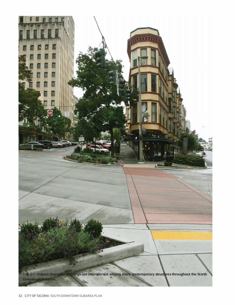
FIG. 2-1 Historic character buildings are interspersed among more contemporary structures throughout the North
Downtown Subarea.
DRAFT
SOUTH DOWNTOWN SUBAREA PLAN CITY OF TACOMA 33
NORTH DOWNTOWNCONTEXT
02
THE NORTH DOWNTOWN SUBAREA
The Downtown Core
DRAFT
34 CITY OF TACOMA SOUTH DOWNTOWN SUBAREA PLAN
FIG. 2-2 SOUTH DOWNTOWN COMPREHENSIVE PLAN “CHARACTER AREAS”
character areas map
DRAFT
SOUTH DOWNTOWN SUBAREA PLAN CITY OF TACOMA 35
St. Helens
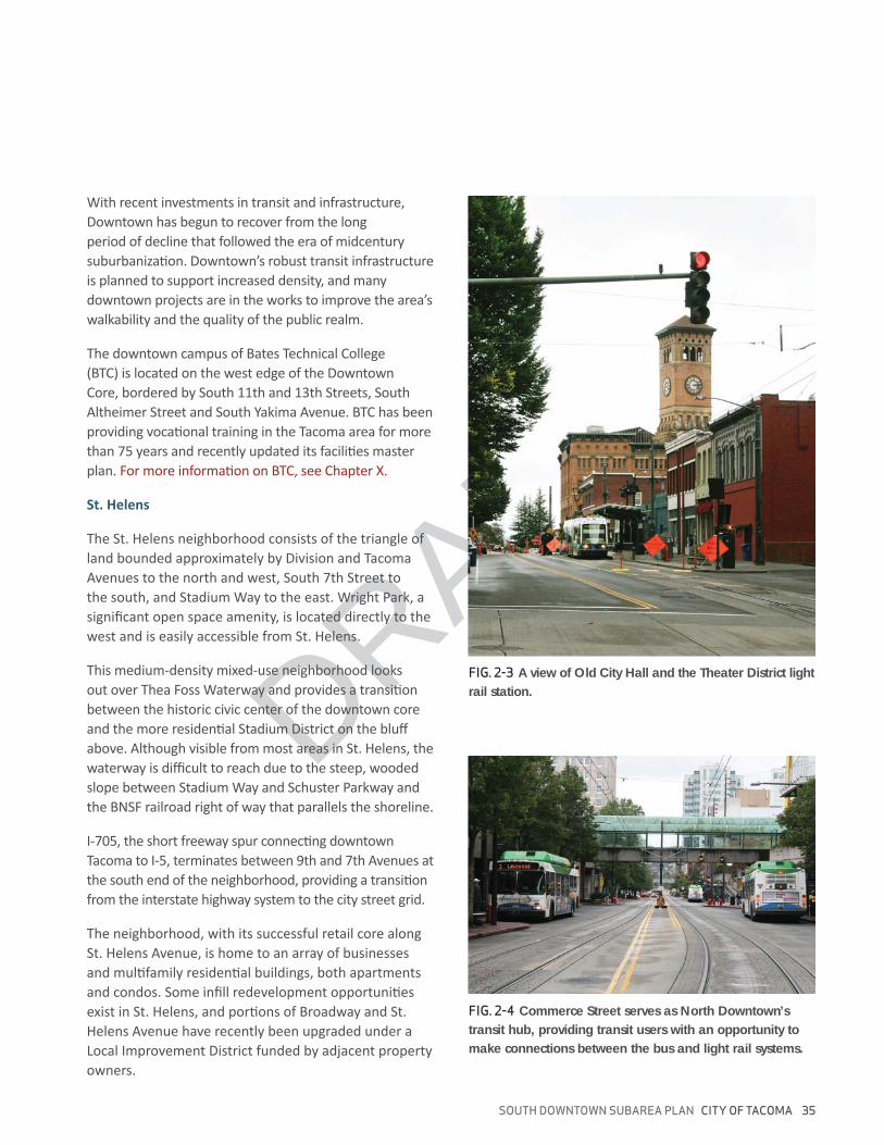
FIG. 2-3 A view of Old City Hall and the Theater District light
rail station.
FIG. 2-4 Commerce Street serves as North Downtown’s
transit hub, providing transit users with an opportunity to
make connections between the bus and light rail systems.
DRAFT
36 CITY OF TACOMA SOUTH DOWNTOWN SUBAREA PLAN
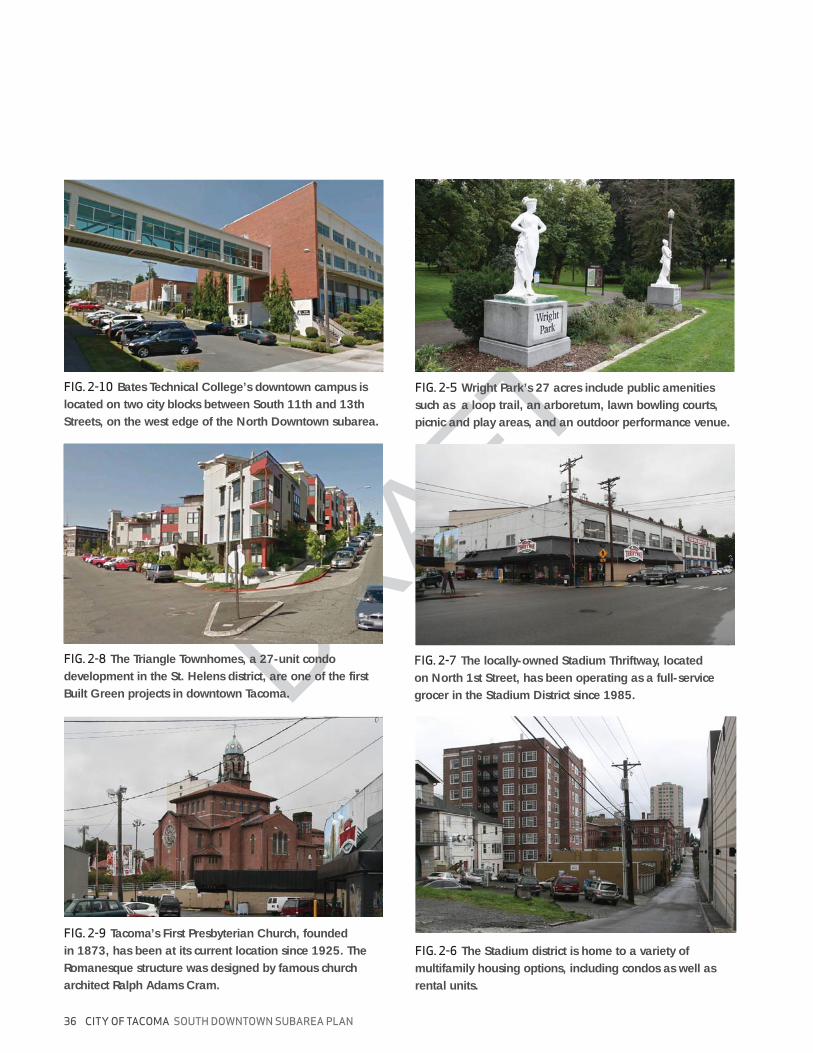
FIG. 2-5 Wright Park’s 27 acres include public amenities
such as a loop trail, an arboretum, lawn bowling courts,
picnic and play areas, and an outdoor performance venue.
FIG. 2-6 The Stadium district is home to a variety of
multifamily housing options, including condos as well as
rental units.
FIG. 2-7 The locally-owned Stadium Thriftway, located
on North 1st Street, has been operating as a full-service
grocer in the Stadium District since 1985.
FIG. 2-8 The Triangle Townhomes, a 27-unit condo
development in the St. Helens district, are one of the first
Built Green projects in downtown Tacoma.
FIG. 2-9 Tacoma’s First Presbyterian Church, founded
in 1873, has been at its current location since 1925. The
Romanesque structure was designed by famous church
architect Ralph Adams Cram.
FIG. 2-10 Bates Technical College’s downtown campus is
located on two city blocks between South 11th and 13th
Streets, on the west edge of the North Downtown subarea.

DRAFT
SOUTH DOWNTOWN SUBAREA PLAN CITY OF TACOMA 37
The Stadium District
The Thea Foss Waterway
FIG. 2-11 Stadium High School, a Tacoma icon, has been
part of the Tacoma Public School system since 1906.
FIG. 2-12 North Downtown has little single family housing
stock. What does exist can be found on the north and west
edges of the Stadium District.
FIG. 2-13 The Center for Urban Waters research facility,
located on the east bank of the Thea Foss Waterway, opened
after the completion of the Superfund site remediation.
38 CITY OF TACOMA SOUTH DOWNTOWN SUBAREA PLAN
1 inch = 1/4 mile
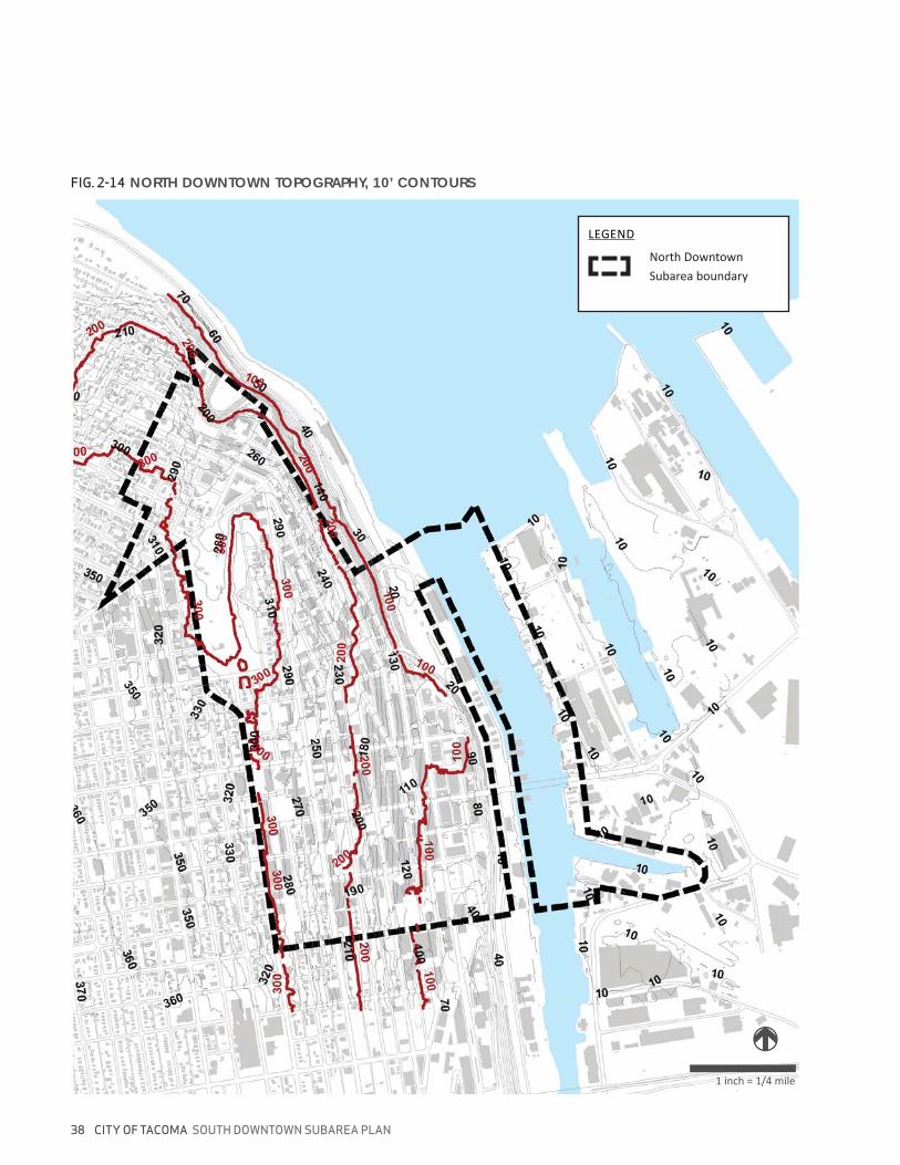
FIG. 2-14 NORTH DOWNTOWN TOPOGRAPHY, 10’ CONTOURS
North Downtown

DRAFT
SOUTH DOWNTOWN SUBAREA PLAN CITY OF TACOMA 39
HISTORY
The Downtown area wa
in Downtown
wa
FIG. 2-15 Renovation work on the Murray Morgan Bridge
was completed in time to celebrate its 100th anniversary in
February of 2013. The bridge serves as an important link
between downtown Tacoma and the Port of Tacoma.
FIG. 2-16 Old City Hall’s freestanding clock tower, which
serves as a downtown landmark, was not part of the original
1893 structure - it was added nine years later, in 1904.
DRAFT
40 CITY OF TACOMA SOUTH DOWNTOWN SUBAREA PLAN
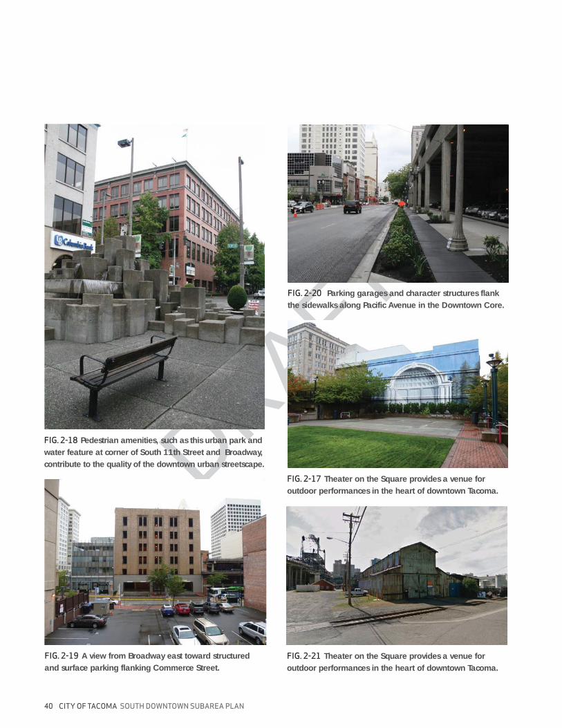
FIG. 2-17 Theater on the Square provides a venue for
outdoor performances in the heart of downtown Tacoma.
FIG. 2-18 Pedestrian amenities, such as this urban park and
water feature at corner of South 11th Street and Broadway,
contribute to the quality of the downtown urban streetscape.
FIG. 2-19 A view from Broadway east toward structured
and surface parking flanking Commerce Street.
FIG. 2-20 Parking garages and character structures flank
the sidewalks along Pacific Avenue in the Downtown Core.
FIG. 2-21 Theater on the Square provides a venue for
outdoor performances in the heart of downtown Tacoma.
DRAFT
SOUTH DOWNTOWN SUBAREA PLAN CITY OF TACOMA 41
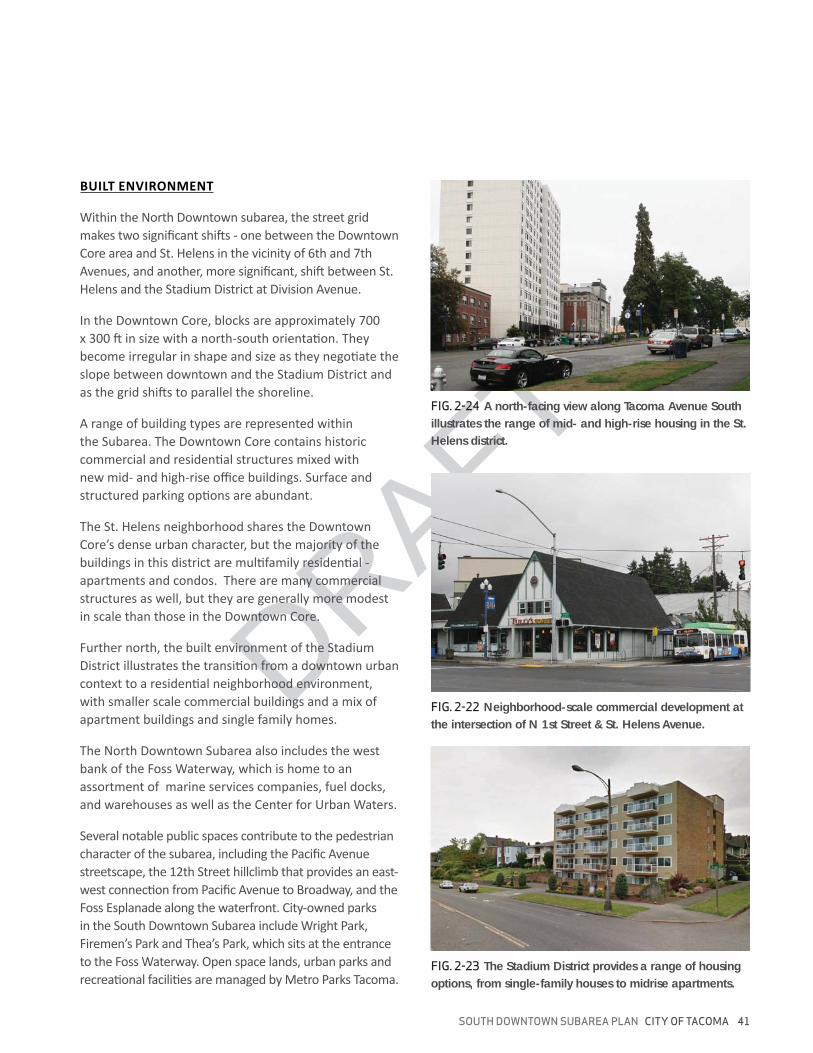
BUILT ENVIRONMENT
FIG. 2-22 Neighborhood-scale commercial development at
the intersection of N 1st Street & St. Helens Avenue.
FIG. 2-23 The Stadium District provides a range of housing
options, from single-family houses to midrise apartments.
FIG. 2-24 A north-facing view along Tacoma Avenue South
illustrates the range of mid- and high-rise housing in the St.
Helens district.
42 CITY OF TACOMA SOUTH DOWNTOWN SUBAREA PLAN
1 inch = 1/4 mile
FossWaterway
Pacific Avenue
South 15th Street
S 6th Avenue
Division Avenue
WrightPark
Tacoma Avenue S
Comm
erce Street
South 11th Street
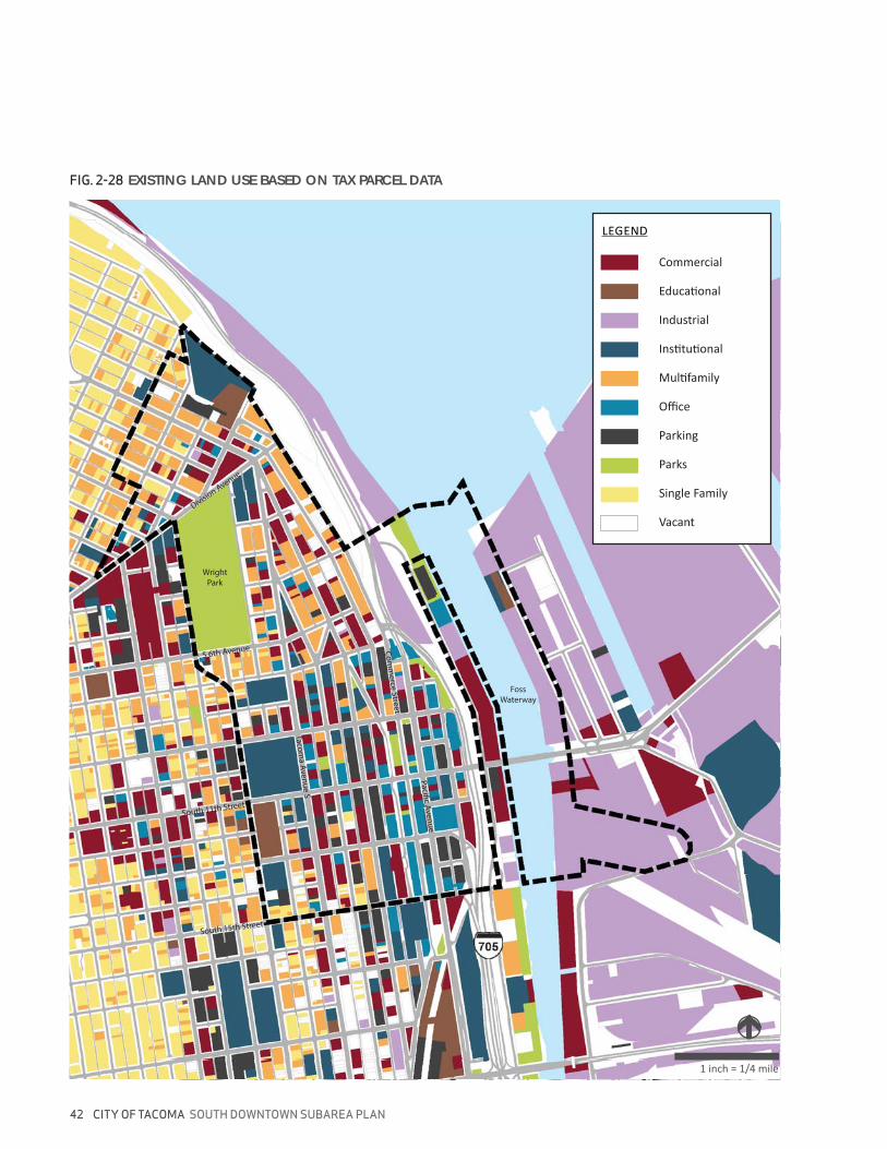
FIG. 2-28 EXISTING LAND USE BASED ON TAX PARCEL DATA
Vacant
DRAFT
SOUTH DOWNTOWN SUBAREA PLAN CITY OF TACOMA 43
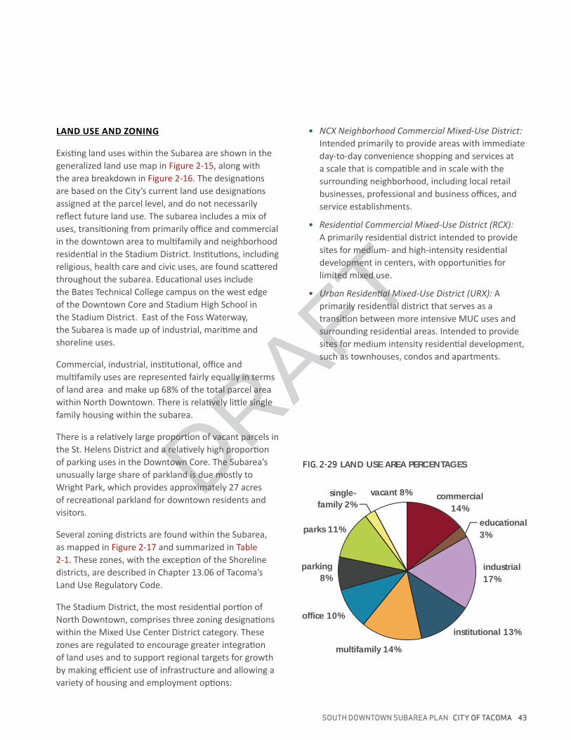
FIG. 2-29 LAND USE AREA PERCENTAGES
vacant 8% commercial
14%
educational
3%
industrial
17%
institutional 13%
single-
family 2%
parks 11%
parking
8%
office 10%
multifamily 14%
LAND USE AND ZONING
44 CITY OF TACOMA SOUTH DOWNTOWN SUBAREA PLAN
LEGEND
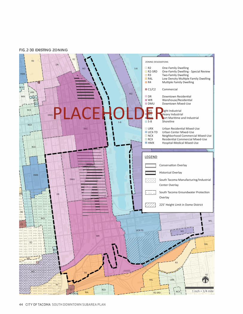
FIG. 2-30 EXISTING ZONING
1 inch = 1/4 mile
HMX
RCX
RCX
NCX
NCX
NCX
RCX
URX
NRX
NCX
HMX
R3
C2
DR
R2
M2
DCC
M2
PMI
PMI
M2
M2
M1
R4L
R3
R2
URX
NCXR2-SRD
R4L
UCX-TD
R4
R4LRCXC2
RCXNCX
R3
M1
R4L
R2
C1
NCX
RCX
C1
R2
R3 DR
DMU
WR
DMU
S-8
S-8
S
R2 One-Family DwellingR2-SRD One-Family Dwelling - Special ReviewR3 Two-Family Dwelling
C1/C2 Commercial
DMU Downtown Mixed-Use
M1 Light IndustrialM2 Heavy Industrial
S-8 Shoreline
UCX-TD Urban Center Mixed-UseNCX Neighborhood Commercial Mixed-Use
HMX Hospital-Medical Mixed-Use
ZONING DESIGNATIONS
1 inch = 1/4 mile
DRAFT
SOUTH DOWNTOWN SUBAREA PLAN CITY OF TACOMA 45
Shoreline
S