13. human healthwesternsydneyairport.gov.au/files/eis/2015/17-volume-2-chapter-13.pdf · 13. human...
TRANSCRIPT

13. Human health
The health risk assessment has considered the risks associated with construction and operation of Stage 1 of the proposed airport on the health of the local community.
The assessment was undertaken in five stages: issue identification, hazard assessment, exposure assessment, risk characterisation, and uncertainty assessment. The assessment focuses on the potential health risks from air, noise, and surface and groundwater pollutant exposure through a comparison with the baseline (existing) situation. These pathways were identified as the likely primary means of potential impact to human health from the development of the proposed airport. The health impact assessment considers impacts from atmospheric particulates, nitrogen dioxide, sulphur dioxide, air toxics (benzene, toluene, xylenes and formaldehydes), diesel, and ozone. Water contaminants considered include petroleum hydrocarbons, heavy metals, polyaromatic hydrocarbons, chlorinated hydrocarbons and perflourinated compounds.
Overall, the assessment found that potential risks to human health are low. This is consistent with the fact pollution from the proposed airport is expected to be within acceptable limits. Having regard to the potential risks, the assessment identifies measures to further reduce the likely human health impacts of the proposed airport, with reference to other chapters in the draft EIS. Following the implementation of the measures proposed in this draft EIS, the human health impacts of the Stage 1 development are likely to be minimal.
13.1. Introduction This chapter considers the risks associated with the construction and operation of the proposed airport on the health of the local community. It draws upon the specialist health risk assessment (see Appendix G) undertaken during the preparation of the draft EIS which considered the risks associated with noise, air and surface/ground water emissions from the proposed airport.
The assessment considers the baseline health profile of the region, identifies key health risks of the construction and operation of the proposed airport, and identifies mitigation measures to minimise impacts to human health.
Overall, the assessment found that the predicted health risk associated with the proposed airport would be in line with national and international standards of acceptability. The implementation of mitigation measures associated with noise, air quality and surface water described in the relevant chapters of this draft EIS would further reduce the predicted risk.
13.2. Methodology The health risk assessment was undertaken in accordance with the Australian Government Guidelines for Health Risk Assessment (enHealth 2012) and the National Health and Medical Research Council Approach to Hazard Assessment for Air Quality (NHMRC 2006). The health risk assessment uses information about pollutants to estimate a theoretical level of risk for people who might be exposed to defined levels. Health statistics for Sydney have been used as a baseline in the assessment, with information on the health risks of pollutants being drawn from scientific studies. Data on existing pollutant levels come from ambient monitoring stations in Western Sydney operated by the NSW Office of Environment and Heritage and the NSW Environment Protection Authority.
Western Sydney Airport – Environmental Impact Statement – Volume 2 169

The assessment is based on a small sample of days when exceedances of the standards are predicted and when there is a good correlation between the model outputs and existing monitoring data obtained from NSW EPA monitoring stations. Given there is only a limited ozone prediction dataset available, a full risk characterisation is not possible. The approach adopted focuses on the potential increase in risk due to changes in ozone only on the days where exceedances are predicted. However, this is considered to be a reasonable approach because the likelihood of health impacts arising in circumstances where there are no or very few relevant exceedances of ozone is very small.
13.3.3. Air toxics A number of air toxics will be emitted during airport operations. Air dispersion modelling has been conducted for benzene, toluene, xylenes and formaldehyde. The most significant potential health risk is cancer from exposure to benzene. The predicted data for benzene has been used in the human health risk assessment for operations of the Stage 1 development in 2030.
To enable the potential increased risk of cancer arising from the airport operations to be evaluated, annual average concentrations of benzene have been modelled. The maximum concentration predicted at any location was 0.1μg/m3. This value has been used to calculate the maximum cancer risk from benzene in the surrounding area.
13.3.4. Diesel Diesel emissions associated with the proposed airport would arise from machinery used during construction activities as well as truck movements to, from and on the site. Diesel emission would also be generated through the use of diesel powered equipment on site during operations.
In recent years there has been increased community concern about the health effects of diesel. Exposure to diesel exhaust can have immediate health effects. Diesel exhaust can irritate the eyes, nose, throat and lungs, and it can cause coughs, headaches, light headedness and nausea. In studies with human volunteers, exposure to diesel exhaust particles at certain intensities made people with allergies more susceptible to the materials to which they are allergic, such as dust and pollen. Exposure to diesel exhaust at certain intensities also causes inflammation in the lungs, which may aggravate chronic respiratory symptoms and increase the frequency or intensity of asthma attacks. Diesel exhaust and many individual substances contained in it (including arsenic, benzene, formaldehyde and nickel) have the potential to contribute to mutations in cells that can lead to cancer.
13.4. Noise Epidemiological studies have found that exposure to environmental noise is consistently associated with cardiovascular diseases. The main health effects associated with environmental noise are:
• sleep disturbance;
• cardiovascular disease;
• cognitive impairment;
Western Sydney Airport – Environmental Impact Statement – Volume 2 171
• tinnitus;
• annoyance; and
• hearing impairment.
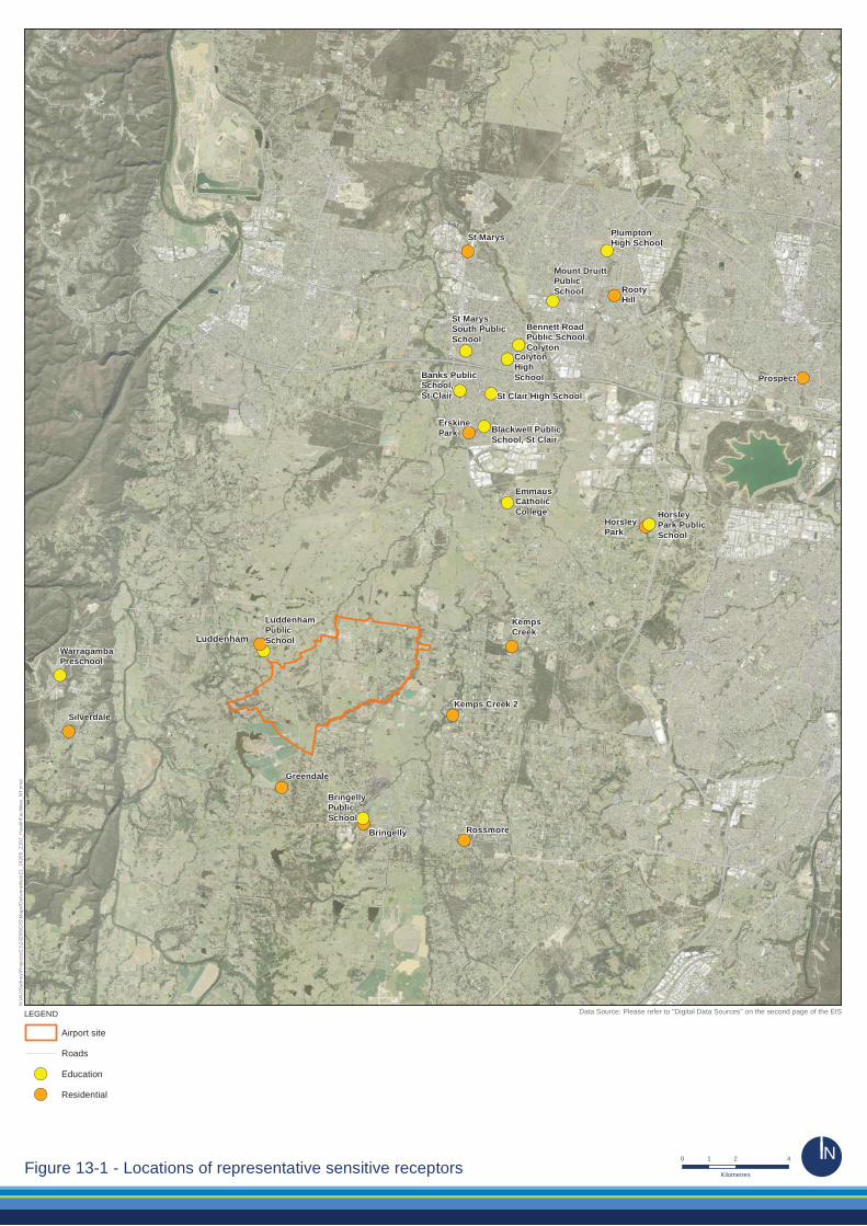
Noise and vibration exposure data for the health risk assessment includes consideration of aircraft overflights as well as ground based noise. Residential areas and schools were identified as sensitive noise receivers in the draft EIS (see Appendix E) and are listed in Table 13–1 and shown in Figure 13–1.
Although the schools have been identified primarily for assessment of the potential impacts on child learning and cognitive development, they are also located in residential areas. Accordingly, the noise levels predicted at these locations would be representative of the exposure to noise for the local community, and have also been used in the assessment of sleep disturbance. Table 13–1 – Representative sensitive noise receivers
Residential areas Bringelly Greendale
Kemps Creek Silverdale
Erskine Park Horsley Park
Rossmore Rooty Hill
St Marys Prospect
Schools Warragamba Preschool Bringelly Public School
Emmaus Catholic College (Kemps Creek) Mount Druitt Public School
Horsley Park Public School St Marys South Public School
Luddenham Public School Colyton High School
Bennett Road Public School (Colyton) Banks Public School (St Clair)
St Clair High School Plumpton High School
Blackwell Public School (St Clair)
Following the enHealth Health Effects of Environmental Noise other than Hearing Loss (2004) and World Health Organisation (WHO) guidelines (2009; 1999), the assessment of the potential impacts of aircraft noise considers the following noise metrics:
• LAeq: a measure of noise which represents the equivalent-continuous noise level averaged over a specified period;
• LAeq,11pm-7am or Lnight,outside: the equivalent-continuous noise level between 11pm and 7am. This metric is used to describe night time noise exposure and assess chronic health impacts associated with noise exposure;
• LAeq,9am-3pm: the equivalent-continuous noise level between 9am and 3pm. This metric is used to assess the impact of noise on school students and teachers; and
172 Western Sydney Airport – Environmental Impact Statement – Volume 2
• LAmax: a measure of the maximum noise level during a specified period. This metric is used to assess of night time noise impacts from aircraft overflights.
Using the findings from the noise impact assessments, the health risk assessment used these metrics to identify the potential for annoyance, sleep disturbance, increased likelihood of cardiovascular disease, and impacts on children’s learning and cognitive development. In all cases, noise levels were calculated at an external point of the building. The noise level within a building would be significantly lower, depending on the building fabric and whether windows and doors are opened.
The predicted noise levels were calculated at specific locations (see Figure 13–1), using assumptions and procedures that are described in detail in the noise assessment reports in Appendix E.
13.5. Ground and surface water Groundwater data from samples collected in 1995 and 1998 were compared to groundwater investigation levels from relevant guideline sources. A qualitative evaluation of the risk potential to identified waterbodies under current conditions at the site and in surrounding areas has been conducted.
The ANZECC (2000) guidelines set out key indicators which can be used to measure whether there is a potential risk to each environmental value. Indicators have been selected based on the appropriate level of protection for the waterways at and surrounding the site. These indicators provide a risk-based approach to assessing the potential for impacts to environmental values.
13.6. Existing environment
13.6.1. Airport site The airport site covers an area of approximately 1,700 hectares located at Badgerys Creek in Western Sydney. The site is located approximately 50 kilometres west of Sydney’s central business district and 15 to 20 kilometres from major population centres such as Liverpool, Fairfield, Campbelltown and Penrith.
The Northern Road transects the western end of the airport site and Elizabeth Drive borders the site to the north. Badgerys Creek flows in a north-easterly direction and forms the south eastern boundary of the airport site. The airport site is located on undulating topography that has been extensively cleared with the exception of stands of remnant vegetation located predominantly along Badgerys Creek and the south western portion of the site.
Western Sydney Airport – Environmental Impact Statement – Volume 2 173
!(
!(
!(
!(
!(
!(
!(
!(
!(
!(
!(
!(
!(
!(
!(
!(!(!(
!(!(
!(
!(
!(
!(
!(Luddenham
Bringelly
KempsCreek
ErskinePark
Kemps Creek 2
St Marys
Greendale
Silverdale
Rossmore
HorsleyPark
WarragambaPreschool
EmmausCatholicCollege Horsley
Park PublicSchool
LuddenhamPublicSchool
BringellyPublicSchool
Mount DruittPublicSchool
St MarysSouth PublicSchool
Bennett RoadPublic School,Colyton
ColytonHighSchool
St Clair High School
Banks PublicSchool,St Clair
Blackwell PublicSchool, St Clair
RootyHill
PlumptonHigh School
Prospect
Airport site
Roads
!( Education
!( Residential
N:\A
U\S
ydne
y\P
roje
cts\
21\2
4265
\GIS
\Map
s\D
eliv
erab
les\
21_2
4265
_Z10
2_H
ealth
Faci
litie
s_N
T.m
xd
LEGEND
0 2 41
KilometresFigure 13-1 - Locations of representative sensitive receptors ÄKKN
Data Source: Please refer to "Digital Data Sources" on the second page of the EIS
13.7. Population profile
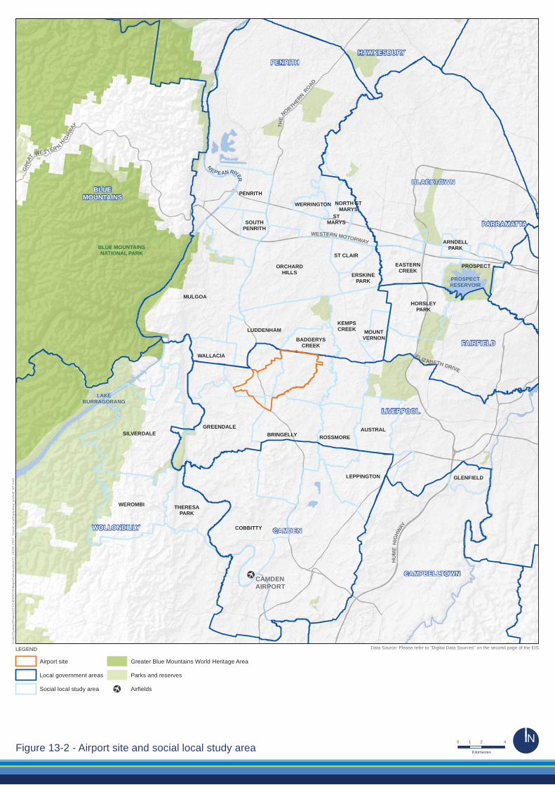
13.7.1. Demography The airport site is located within the Liverpool local government area (LGA). The Liverpool LGA is bounded by Fairfield, Penrith, Camden, Wollondilly and Bankstown LGAs (see Figure 13–2).
Population statistics for the 2011 Census have been obtained from the Australian Bureau of Statistics for each of the localities surrounding the airport which have been considered in the health risk assessment. These statistics are shown in Table 13–2, with the localities sorted in order of increasing population size. It is noted that the stated population of Badgerys Creek would have included tenants on the airport site, however as the majority of these tenants have relocated, the current population would now be much lower.
The South West Sydney Local Health District forecasts in its Liverpool Community Health Profile (2014) that the population of Liverpool LGA will increase significantly from 188,088 people in 2011 to 288,959 in 2031. The highest rate of growth is anticipated in the age cohort 45-69.
13.7.2. Socioeconomic status Consistent with assumptions found generally in epidemiological studies, people who are of a low socioeconomic status have been identified as a vulnerable group for the effects of air, noise and water pollution for the purposes of the health impact assessment. This is largely due to the fact that people within these groups usually have a poorer health status, may have limited access to medical care, and may live in more affordable areas which generally experience higher rates of pollution (e.g. near major roads or industry).
The health risk assessment adopts the Socioeconomic Indexes for Areas (SEIFA) as a measure of relative social disadvantage. This measure takes into account 20 variables (including income levels, educational attainment, unemployment, vocational skills).
SEIFA scores in Table 13–2 indicate that there are areas within the vicinity of the proposed airport with a lower socioeconomic status than the Australian average (SEIFA score of 1,000) or Sydney as a whole (SEIFA score of 1,025). The localities of Badgerys Creek, St Marys, Mount Druitt, Rooty Hill, Colyton and Warragamba all have low SEIFA scores indicating that the populations in these localities may be vulnerable to the effects of air, noise and water pollution from the proposed airport.
13.7.3. Health baseline A baseline health status of the Liverpool LGA was prepared by the South West Sydney Local Health District as part of their 2014 Community Health Profile (see Table 13–3). This table summarises the key indicators for hospitalisations and mortality in the Liverpool LGA, compared to the average for NSW over the same period. Whilst Liverpool experiences a relatively higher number of coronary heart disease, diabetes, and fall related hospitalisations, it is generally comparable to the NSW health profile, having regard to the full range of measured health indicators for the population.
Western Sydney Airport – Environmental Impact Statement – Volume 2 175
[·
ELIZABETH DRIVE
NEP EAN RIVER
PROSPECTRESERVOIR
LAKEBURRAGORANG
THE
NORTHERNROAD
HU
ME
HIG
HWAY
WESTERN MOTORWAY
GREA
T WES TER NHI G
HWAY
BLUE MOUNTAINSNATIONAL PARK
AUSTRAL
PROSPECT
HORSLEYPARK
NORTH STMARYS
STMARYS
WEROMBI
PENRITH
LEPPINGTON
BRINGELLY
BADGERYSCREEK
KEMPSCREEKLUDDENHAM
ORCHARDHILLS
WERRINGTON
GREENDALE
ROSSMORE
MOUNTVERNON
SILVERDALE
SOUTHPENRITH
GLENFIELD
ARNDELLPARK
EASTERNCREEK
ERSKINEPARK
ST CLAIR
COBBITTY
THERESAPARK
WALLACIA
MULGOA
HAWKESBURY
LIVERPOOL
BLUEMOUNTAINS
CAMDEN
FAIRFIELD
PARRAMATTA
BLACKTOWN
CAMPBELLTOWN
PENRITH
WOLLONDILLY
CAMDENAIRPORT
Airport site
Local government areas
Social local study area
Greater Blue Mountains World Heritage Area
Parks and reserves
[· Airfields
N:\A
U\S
ydne
y\P
roje
cts\
21\2
4265
\GIS
\Map
s\D
eliv
erab
les\
21-2
4265
-Z09
7_S
ocia
lLoc
alS
tudy
Are
a_po
rtrai
t_N
T.m
xd
LEGEND
0 2 41
KilometresFigure 13-2 - Airport site and social local study area ÄKKN
Data Source: Please refer to "Digital Data Sources" on the second page of the EIS
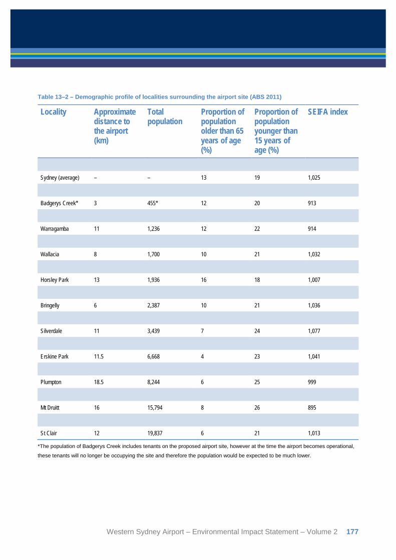
Table 13–2 – Demographic profile of localities surrounding the airport site (ABS 2011)
Locality Approximate distance to the airport (km)
Total population
Proportion of population older than 65 years of age (%)
Proportion of population younger than 15 years of age (%)
SEIFA index
Australia (average) – – 14 19 1,000
Sydney (average) – – 13 19 1,025
Greendale 8 352 11 22 986
Badgerys Creek* 3 455* 12 20 913
Mt Vernon 8 1,036 11 20 1,102
Warragamba 11 1,236 12 22 914
Luddenham 3 1,496 12 22 1,034
Wallacia 8 1,700 10 21 1,032
Mulgoa 8.5 1,792 12 20 1,065
Horsley Park 13 1,936 16 18 1,007
Kemps Creek 6 2,309 15 19 993
Bringelly 6 2,387 10 21 1,036
Rossmore 8 2,412 13 22 997
Silverdale 11 3,439 7 24 1,077
Prospect 21 4,621 9 21 1,031
Erskine Park 11.5 6,668 4 23 1,041
Colyton 13 7,993 11 22 930
Plumpton 18.5 8,244 6 25 999
St Marys 14 10,961 14 21 881
Mt Druitt 16 15,794 8 26 895
Rooty Hill 17 13,377 12 22 970
St Clair 12 19,837 6 21 1,013
*The population of Badgerys Creek includes tenants on the proposed airport site, however at the time the airport becomes operational,
these tenants will no longer be occupying the site and therefore the population would be expected to be much lower.
Western Sydney Airport – Environmental Impact Statement – Volume 2 177
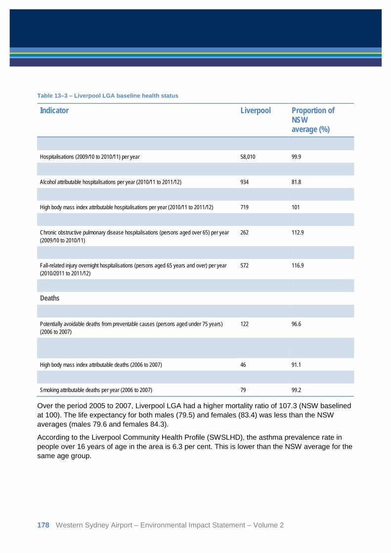
Table 13–3 – Liverpool LGA baseline health status
Indicator Liverpool Proportion of NSW average (%)
Hospitalisations
Hospitalisations (2009/10 to 2010/11) per year 58,010 99.9
Potentially preventable hospitalisations per year (2010/11 to 2011/12) 3,850 95.4
Alcohol attributable hospitalisations per year (2010/11 to 2011/12) 934 81.8
Smoking attributable hospitalisations per year (2010/11 to 2011/12) 905 100.5
High body mass index attributable hospitalisations per year (2010/11 to 2011/12) 719 101
Coronary heart disease hospitalisations per year (2009/10 to 2010/11) 821 91.2
Chronic obstructive pulmonary disease hospitalisations (persons aged over 65) per year (2009/10 to 2010/11)
262 112.9
Diabetes hospitalisations per year (2009/10 to 2010/11) 515 132.1
Fall-related injury overnight hospitalisations (persons aged 65 years and over) per year (2010/2011 to 2011/12)
572 116.9
Stroke hospitalisations per year (2010/11 to 2011/12) 196 97.6
Deaths
Potentially avoidable deaths (persons aged under 75 years) per year (2006 to 2007) 211 99.5
Potentially avoidable deaths from preventable causes (persons aged under 75 years) (2006 to 2007)
122 96.6
Potentially avoidable deaths from causes amenable to health care (persons aged under 75 years) per year (2006 to 2007)
84 97.8
High body mass index attributable deaths (2006 to 2007) 46 91.1
Alcohol attributable deaths per year (2006 to 2007) 23 94.6
Smoking attributable deaths per year (2006 to 2007) 79 99.2
Over the period 2005 to 2007, Liverpool LGA had a higher mortality ratio of 107.3 (NSW baselined at 100). The life expectancy for both males (79.5) and females (83.4) was less than the NSW averages (males 79.6 and females 84.3).
According to the Liverpool Community Health Profile (SWSLHD), the asthma prevalence rate in people over 16 years of age in the area is 6.3 per cent. This is lower than the NSW average for the same age group.
178 Western Sydney Airport – Environmental Impact Statement – Volume 2
13.7.4. Existing air quality Air quality monitoring data collected between 2005 and 2014 from the NSW Office of Environment and Heritage monitoring stations in Bringelly, Macarthur/Campbelltown West, Liverpool and Richmond was used to describe the existing air quality in Badgerys Creek. A detailed outline of the available air quality data is provided in Appendix F1. Generally, air quality for the local area is good, with the exception of isolated high pollution days or extreme events such as dust storms and bushfires.
13.7.5. Existing hydrogeology There are two principal local aquifers present beneath the airport site:
• a shallow alluvial aquifer which is considered to be localised around the main creeks which drain the site and is generally encountered at depths of approximately 0.7-4.7 metres below ground level; and
• a confined aquifer within the Bringelly Shale which is present at approximately 20 metres below ground level.
Perched groundwater may be intermittently encountered within the weathered shale profile, however it is not considered to be a continuous aquifer. In addition, a deep regional aquifer may be present at depths of greater than 100 metres below ground level within the Hawkesbury Sandstone.
It is unlikely the aquifers are interconnected based on geological information, water strike observations and groundwater elevation data. Both of the main aquifers present beneath the site are reported to have low hydraulic conductivity (0.0027-0.14 m/day).
Standing water level elevations (in surrounding registered bores) suggest that there is a strong downward head gradient between the Bringelly Shale aquifer and the underlying Hawkesbury Sandstone aquifer, which suggests that there is limited prospect of any hydraulic connectivity between the aquifers.
The Luddenham Dyke (which runs south-east to north-west in the south-west area of the site) is observed to create a divide in the Bringelly Shale aquifer with flow on the eastern side towards Badgerys Creek and on the western side towards Duncans Creek.
There are 42 registered groundwater bores within a five kilometre radius of the airport site. Twelve of these bores are registered as being used for domestic, stock, industrial, farming and irrigation purposes; these wells range in depth from 61-337 metres below ground level. The depth of registered extraction bores indicates that groundwater users extract water from the Hawkesbury Sandstone aquifer. This aquifer is known to be of higher value than the groundwater from the Bringelly Shale, which is of relatively poor quality.
Western Sydney Airport – Environmental Impact Statement – Volume 2 179

13.7.6. Existing surface water conditions Two main catchments drain the site: the South Creek Catchment and the Nepean River Catchment. There are several waterways that are within, or in the vicinity of, the airport site:
• Duncans Creek is located to the south-west of the site and drains to the Nepean River west of the airport site;
• Oaky Creek flows through the central and northern area of the airport site and then drains to Cosgroves Creek;
• Cosgroves Creek flows along to the north-west and north of the airport site, before draining into South Creek to north east of the site;
• Badgerys Creek flows along the southern and south-eastern boundary of the airport site and then drains to South Creek to the north east of the airport site; and
• Thompsons Creek is located to the south-east of the airport site and drains to South Creek to the south-east of the airport site.
Each of the above listed waterways has a number of small tributaries which drain the airport site and areas in the vicinity. Many of the creeks which drain the airport site and surrounding area may not flow continuously. During dry periods, only intermittent pools of water may remain along the creek beds.
Warragamba Dam is located approximately eleven kilometres west of the airport site and is one of Sydney’s major drinking water supply dams. Prospect Reservoir is located approximately 18 kilometres north-east of the site. Prospect Reservoir is a potable water supply which is used during periods of high demand. The airport site is not located within the catchment area for either the dam or the reservoir. There are also numerous farm storage dams on and surrounding the airport site, as well as rain water tanks on properties around the site used for potable water.
The following uses of surface water have been identified on the airport site and surrounding areas:
• agricultural use, such as farm dams used for stock water and irrigation, and ecological habitat;
• potable untreated/pre-treatment domestic supply (Warragamba Dam and Prospect Reservoir);
• non-potable domestic use; and
• industrial use, with a few large scale industrial operations in the area observed to have large dams adjacent to their facilities, indicating that this water may be used for industrial purposes.
180 Western Sydney Airport – Environmental Impact Statement – Volume 2
13.8. Assessment of impacts during construction
13.8.1. Air quality Air quality modelling conducted for the construction phase has provided annual average and 24-hour average PM10 and PM2.5 for the following activities:
• bulk earthworks; and
• construction of aviation infrastructure, including:
construction plant
concrete batching plant.
Details of the modelling and sources considered are provided in the local air quality assessment (see Chapter 12).
13.8.2. Particulates Air quality modelling shows that 24 hour average PM10 levels from bulk earthworks would be below the current National Environmental Protection Measure (NEPM) standard of 50µg/m3 at all residential locations assessed. The highest concentration is predicted at Badgerys Creek.
The highest predicted risk is for all-cause mortality from long-term exposures with between one additional death per 1000 years and one additional death per 100 years that are attributable to PM10. All other risks would be lower than that predicted for long-term mortality.
As with PM10, the predicted PM2.5 concentrations are low and below the NEPM advisory reporting standard of 25µg/m3. The highest concentrations are predicted for Greendale and Badgerys Creek.
The highest predicted risk attributable to PM2.5 is for all-cause mortality and cardiopulmonary mortality from long-term exposures with between seven additional deaths per 10,000 years and four additional deaths per 1,000 years.
The predicted PM10 concentrations are higher than those during bulk earthworks but are still below the NEPM standard. The highest concentration is at Badgerys Creek. As with PM10, the predicted PM2.5 concentrations are higher than those predicted for bulk earthworks but still in compliance with the NEPM advisory reporting standard. The highest concentrations are predicted for Badgerys Creek, Greendale and Rossmore.
The highest predicted risks attributable to PM10 are for all-cause mortality from long-term exposures with between two additional deaths per 1000 years and one additional death per 100 years. The highest impacts are predicted at Luddenham, Bringelly, Kemps Creek and Badgerys Creek.
The highest predicted risks attributable to PM2.5 are for all-cause mortality from long-term exposures with between three additional deaths per 1,000 years and two additional deaths per 100 years. All other risks are lower than that predicted for these outcomes. The highest predicted impacts are at Bringelly and Luddenham.
Western Sydney Airport – Environmental Impact Statement – Volume 2 181

It should be noted that the construction of Stage 1 development would occur for a period of less than 10 years. Therefore the predicted risk levels associated with the construction phase are unlikely to be realised as they are predicted to occur over much longer timeframes (100 to 10,000 years).
13.8.3. Diesel The increase in cancer risk has been calculated for the diesel particle inhalation pathway. International agencies have published unit risk factors (URF) for diesel. The URF is an estimate of the increase in risk with exposure to 1 µg/m3 of the pollutant over a lifetime. For the purposes of this assessment, a lifetime is assumed to be 70 years. To calculate the lifetime cancer risk associated with the concentrations of diesel predicted to arise from emissions from the airport operations, the following equation has been used:
Increase in lifetime cancer risk = annual average concentration x URF
A review of the available unit risk factors has been undertaken as part of the health risk assessment. The URF from a guideline produced by the Californian Environment Protection Authority (California EPA) has been used in this study. The URF used to calculate the increased risk of cancer is 3 x 10⁻⁴ per 1μg/m3 for the operations of the airport in 2030.
The health risk assessment predicts an increase in cancer risk attributable to diesel particles ranging from 1.3 x 10⁻⁶ to 8.4 x 10⁻⁶ per 1μg/m3. Accordingly, the resultant cancer risk estimates are demonstrated to fall within levels for risk generally considered acceptable to regulators (by two orders of magnitude).
13.8.4. Noise Construction noise impacts have been assessed in Chapter 11 and Appendix E2. Construction noise has the potential to result in minor exceedances to adopted criteria during earthworks undertaken in the north western sector of the site. Noise levels during construction fall within the ground based noise levels predicted for the airport operations. As such, construction noise is not anticipated to result in significant health risks to the surrounding community.
The airport site covers a broad area, and a range of management measures such as the placement of temporary noise barriers or exclusion buffers within the airport site could be considered with a view to mitigating disturbance to nearby receivers from construction activity.
182 Western Sydney Airport – Environmental Impact Statement – Volume 2

13.9. Water
13.9.1. Local surface water catchment The following activities during construction of the airport have the potential to result in impacts on surface water bodies:
• earthmoving activities and/or vegetation clearance resulting in potentially increased sediment loading in surface run-off;
• accidental spills of fuels or chemicals from construction vehicles which may discharge into surface water environments; and
• discharge of collected groundwater to surface water bodies which may contain potential contaminants that have not been adequately assessed prior to discharge.
These risks are typical of most major construction projects and standard precautionary measures are considered to be appropriate to address these issues. The recommended monitoring, management and mitigation measures identified in Chapter 18 are expected to reduce the potential for these risks to be realised during airport construction.
13.9.2. Sydney’s drinking water catchment Construction of the proposed airport is not located within the catchments for Warragamba Dam or Prospect Reservoir. However, there is potential that airborne particles from construction may be deposited within these two waterbodies through dispersion of airborne dust, potentially affecting water quality.
Warragamba Dam is approximately eleven kilometres from the airport site. Dispersion modelling forecasts an annual average deposition rate of 0.02µg/m3 from the airport construction at Warragamba. This is unlikely to represent a significant risk to water quality. Prospect Reservoir is located further away, approximately 18 kilometres from the site. Airborne particle deposition is therefore also unlikely to be a significant risk for this site, given the separation distance.
Dust suppression mitigation measures outlined for air quality in Chapter 12 would further reduce the risk of these impacts.
13.10. Assessment of impacts during operation
13.10.1. Air quality Overall, the analysis found that the health impacts associated with air quality impacts from the operation of the proposed airport would be in line with national and international standards of acceptability. This is consistent with the air quality assessments which found that emissions from the proposed airport would be within the relevant standards.
Western Sydney Airport – Environmental Impact Statement – Volume 2 183
The analysis presented in this section should be viewed in the context of overall health in the Sydney basin. In particular, evidence provided by NSW Health to a Parliamentary Inquiry into health effects of pollution showed that in 2006 it was estimated that between 600 and 1,400 deaths per year were attributed to air pollution in the Sydney basin (NSW Parliament 2006). Based on these figures, the health impacts associated with emissions from the operation of the proposed airport are expected to represent a small increase in current rates of long-term mortality associated with air pollution.
13.10.2. Particulates Annual average and 24-hour emissions for particulate matter (PM10 and PM2.5) have been modelled as part of the air quality assessment. The average 24 hour NEPM ambient air quality standard for PM10 and PM2.5 are 50μg/m3 and 25μg/m3 respectively and all predictions for emissions from operations of the proposed airport are below these levels.
The highest predicted 24 hour average PM10 concentration for airport operations is predicted at Kemps Creek and Rossmore, with a maximum level of less than 16μg/m3. The highest predicted 24 hour average PM2.5 concentration for airport operations is predicted for Kemps Creek, Badgerys Creek, Rossmore and Mulgoa, with a maximum level of less than 7μg/m3.
Noting the predicted levels are within the relevant standards, the highest risk is for all-cause mortality from long-term exposures with between one additional death per 1,000 years and one additional death per 10 years attributable to PM10. The highest risk is predicted for Kemps Creek with an additional one death per 10 years predicted in a population of 2,309.
Similar to PM10, the numbers of cases attributable to PM2.5 are low. The highest risk is for all-cause mortality and cardiopulmonary mortality from long-term exposures with between one additional death per 1,000 years and six additional deaths per 100 years. The highest risks are predicted for Kemps Creek and Rossmore which have a total population of 4,721. This increase in deaths is relative to the current health baseline in these areas. All other risks are lower than that predicted for these outcomes.
13.10.3. Nitrogen dioxide The daily 24-hour nitrogen dioxide concentrations at residential receivers are predicted to be low. The air quality assessment identified that for all relevant averaging periods, the nitrogen dioxide levels due to the airport operations would be well below the current NEPM air quality standards. The levels predicted at all residential locations are similar, with slightly higher levels at Kemps Creek.
Based on the modelling data, the highest risk is for long-term mortality in people over 30 years of age with between six additional deaths every 100 years and six additional deaths in 10 years predicted. This risk relates to the combined emissions from the airport as well as airport-generated traffic on roads external to the airport.
Although the predicted air pollution levels meet the NEPM standards, it is recognised in epidemiological studies that there is no threshold for nitrogen dioxide below which adverse health effects are not observed. This means that even meeting the air quality standards means that there is a level of risk associated with exposure to nitrogen dioxide.
184 Western Sydney Airport – Environmental Impact Statement – Volume 2
To enable an assessment of the risk posed by nitrogen dioxide emissions from airport operations in isolation, additional air dispersion modelling was conducted in the absence of traffic on roads outside the airport site. This enabled an assessment of the contribution of airport operations to the overall risk from exposure to nitrogen dioxide and helped to identify what mitigation could be implemented to reduce the overall risk. Without traffic emissions, airport operations alone may lead to four additional deaths every 10 years due to nitrogen dioxide.
It should be noted that the health risk assessment predictions do not take into account the implementation of any mitigation measures proposed in the draft EIS to reduce nitrous oxide emissions. The implementation of these mitigation measures identified in Chapter 12 and 15 would reduce the predicted health risks associated with air quality emissions.
13.10.4. Sulphur dioxide Air dispersion modelling has predicted maximum 1-hour, 24-hour average and annual average sulphur dioxide concentrations for a range of receivers in the vicinity of the airport site. The daily 24-hour sulphur dioxide concentrations at the most affected receivers show that all levels are below the current NEPM air quality standard of 228μg/m3. The levels are similar across most locations but higher at the receivers in Badgerys Creek, Greendale and Mount Vernon.
The results of the air quality assessment show that the risk from exposure to sulphur dioxide from the airport operations in 2030 is very low. Based on the modelling data, the highest risk is for hospital admissions from respiratory causes, with approximately three additional admissions per 1,000 years. Other risks associated with sulphur dioxide exposure are lower than this.
13.10.5. Carbon monoxide The air dispersion modelling conducted as part of the local air quality assessment provided daily 8 hour maximum carbon monoxide levels for the worst affected locations in the vicinity of the airport site. The data indicates that the predicted carbon monoxide levels are higher at Kemps Creek, Bringelly, Rossmore and Badgerys Creek, however all predicted carbon monoxide concentrations are well below the NEPM standard of 10 mg/m3.
The modelling results indicate that the predicted health effects associated with the proposed airport are very low. The highest risk is for hospital admissions for cardiovascular disease in people 65 years of age and older with a maximum of an additional five hospital admissions in 1,000 years. This risk is negligible.
13.10.6. Air toxics The maximum predicted cancer risk was estimated using a unit risk factor adopted by the California EPA. The modelled maximum annual average concentration was 0.1 µg/m3, resulting in an increase in cancer risk of 2.9 x 10⁻⁶.
It is generally accepted by national and international regulatory agencies that an increase in risk between 1 x 10⁻⁶ (one in a million) and 1 x 10⁻⁵ (one in 100,000) is considered to be a low risk and therefore acceptable. The maximum predicted increase in cancer risk from exposure to benzene is very small and is well within the acceptable range.
Western Sydney Airport – Environmental Impact Statement – Volume 2 185

13.10.7. Ozone Peak daily ozone concentrations have been predicted for a number of days of airport operations in 2030 and the largest changes in ozone concentration have been calculated. Increases in ozone occur downwind of the airport site which, on most days, is to the south and southwest. Decreases in daily maximum ozone occur only in the vicinity of the airport site and are attributable to ozone suppression by fresh nitrous oxide emissions.
For the base year of 2009, the resulting risk for the outcomes assessed is between two in a million (respiratory mortality) and 1.8 in 100,000. For Stage 1 operations, the increase in risk ranges from one in a million for respiratory mortality to nine in a million for emergency department attendances for asthma in children. The largest predicted ozone concentration changes from the airport occur in a different location to the predicted daily peak ozone concentrations.
There is general agreement by international agencies including the World Health Organisation and the US EPA that acceptable risk levels fall between one in a million and one in 100,000. The increases in risk for the days assessed in the regional air quality assessment, fall well within these limits.
13.10.8. Noise The assessment of health risks associated with aircraft noise and ground-based noise from the operation of the Stage 1 development are based on the findings of noise exposure presented in Chapter 10 and Chapter 11 of this draft EIS. The predicted risks associated with aircraft noise consider the differences associated with potential operating modes at the proposed airport (i.e. Prefer 05, Prefer 23 and head to head). Further information on these operating modes can be found at Chapter 10 of this draft EIS.
For night-time aircraft noise during Stage 1, under all potential airport operating modes, the results indicate that the highest noise levels are predicted at Luddenham. All other areas assessed would be below the WHO 40 dB criterion, which is the level of lowest observed adverse effects to public health. Regarding daytime noise levels during Stage 1, the highest noise levels of between 44-46 dB are also predicted at Luddenham. The noise levels at all other locations are predicted to be below 40 dB.
As outlined in Section 13.4, the health risk assessment considered three health outcomes for exposure to noise:
• sleep disturbance;
• increase in myocardial infarction; and
• effects on learning and cognitive development in children.
Dose-response relationships were adopted from the WHO for myocardial infarctions and induced awakenings. The dose-response relationships are derived from empirical studies and measure the risk relative to a change of an underlying variable, which in this case is noise.
186 Western Sydney Airport – Environmental Impact Statement – Volume 2
Regarding the potential for sleep disturbance, the relevant metric used is EEG awakenings. An EEG awakening is a measure of disturbed sleep that is less than a fully awakened state. The European Environment Agency (2010) noted that per person, there are usually 24 awakenings per night, even during an undisturbed 8-hour sleep. For most operating modes the aircraft noise associated with aircraft traffic from the proposed airport would not increase this number. Lnight outside noise results indicate that the Prefer 05 mode results in more EEG awakenings across more localities than the Prefer 23 mode. The use of the head to head mode could reduce the number of EEG awakenings in some instances compared to both the Prefer 05 mode and the Prefer 23 mode.
The areas with the highest number of EEG awakenings are Luddenham (which has the highest number of awakenings overall no matter which operating mode is selected) and Silverdale. In both these cases, the use of head to head operating mode does not reduce the potential incidence of EEG awakenings as at other localities. The number of additional EEG awakenings per person per year due to aircraft noise is estimated to be between 0 and 40 (i.e. a 0-0.4 per cent increase) across all operating mode options. When the predicted additional EEG awakenings are considered in relation to the European Environment Agency (2010) findings above, the number of predicted additional EEG awakenings is very low.
To identify the potential for noise impacts on the learning and cognitive development of children, the WHO hazard quotient method was applied to daytime noise levels. A hazard quotient is the ratio of the potential exposure to a substance and the level at which no adverse effects are expected. If the forecast hazard quotient is less than 1, then no adverse health effects are expected as a result of exposure to the hazard. If the hazard quotient is greater than 1, then adverse health effects are possible. It should be noted that a hazard quotient exceeding 1 does not necessarily mean that adverse effects will occur.
The WHO has identified that the noise level for potential increases for myocardial infarction (heart attacks) is 55 dB Lnight, outside. For all receivers assessed for overflight noise impacts, the Lnight, outside predicted levels were below 55 dB. This was observed for all years assessed and all operating modes. On the basis of these results, it can be concluded that aircraft noise would not lead to any increased risk in myocardial infarction in communities in the vicinity of the airport site.
Having regard to the airport proposal, most hazard quotients are less than one, indicating that the risk from the aircraft overflight noise from each of the proposed modes of operation generally do not pose an unacceptable risk (enHealth 2012).
In some cases there are marginal exceedances of one. This does not mean that there will be an impact on children’s learning and cognitive development but that there is an increased risk, albeit very low.
Noise mitigation measures proposed in Chapter 10 of the EIS would reduce this potential risk.
13.10.9. Ground based operations Noise from ground based operations (airport operational noise on the ground) has the most impact on the localities closest to the proposed airport, in particular Luddenham. The combined effects of aircraft overflight and ground based operations noise is predicted to lead to an additional 13 to 15 EEG awakenings (i.e. a 0.15 to 0.17 per cent increase) per year per person, depending on the operational mode adopted.
Western Sydney Airport – Environmental Impact Statement – Volume 2 187

For ground based sources, the Lnight outside levels predicted for Luddenham exceeded the 55dB threshold. Based on the WHO exposure response curve, the levels predicted for Luddenham may result in an increase in myocardial infarction of approximately two per cent. In terms of children’s learning and cognitive development from ground based operational noise, the hazard quotients experienced at Luddenham exceed one.
Noise mitigation measures proposed in Chapter 11 of this EIS may reduce this potential risk.
13.10.10. Water A number of activities undertaken during the operation of the proposed Western Sydney Airport have the potential to result in the contamination of ground and surface water. These activities include chemical and fuel storage, equipment operation, equipment maintenance and firefighting. Potential contaminants include petroleum hydrocarbons, heavy metals, polyaromatic hydrocarbons, perflourinated compounds and chlorinated hydrocarbons.
Aqueous film-forming foams (AFFF) have historically been used for firefighting purposes at airports, at fuel depots, hangars and for aviation rescue and fire-fighting (for both operational and training purposes). AFFF products historically used on airport sites contain perfluorinated or polyfluorinated compounds, or fluorosurfactants (PFCs). Depending on the type of AFFF used, the principal PFC constituents could have included perfluorooctane sulfonate (PFOS) and perfluorooctanoic acid (PFOA) and fluorotelomers such as 6:2 fluorotelomer sulfonate (6:2FtS) and 8:2 fluorotelomer sulfonate (8:2FtS).
AFFF has not been used for aviation rescue and fire-fighting by Airservices Australia since 2010, but continues to be used around fuel depots and hangars at many airports (GHD 2015 b).
13.10.11. Groundwater Based on available information relating to the types of activities which will be conducted during construction and operation of the airport, there is considered to be minor potential for risks to the environmental values of groundwater in the alluvial and Bringelly Shale aquifers.
Groundwater bores are recorded as being constructed to significant depths and are understood to target the underlying Hawkesbury Sandstone aquifer.
The management and mitigation measures identified in Chapter 18 would be implemented to reduce the potential for these risks to occur. It is noted however that the potential for exposure to groundwater contaminants by off-site users of extracted groundwater is minimal as bores draw from the Hawkesbury Sandstone aquifer.
13.10.12. Surface water The indicative flight paths for the proposed Stage 1 development are located above the catchment areas for Warragamba Dam and Prospect Reservoir. In addition, through consultations there have been concerns raised by parts of the community about the potential for aircraft emissions to impact on the quality of tank water in the area close to the airport site.
188 Western Sydney Airport – Environmental Impact Statement – Volume 2
A qualitative evaluation was conducted to understand the potential for these activities, and activities at the airport site, to impact on surface water bodies in and around the airport site. The following operational activities were considered for their potential to impact on surface water:
• the accidental spill of stored chemicals or fuels from vehicles, which may be released to nearby surface water environments;
• the release of stored groundwater, which has not been adequately characterised with regard to contamination concentrations, to surface water bodies;
• the deposit of aircraft emissions to nearby surface water bodies which may result in increased contaminant loading to waterways; and
• the very rare event of aircraft jettisoning fuel during emergency incidents as aircraft approach the site.
Based on available information there is considered to be a low risk for operation of the proposed airport to impact on the environmental values of surface water.
In relation to accidental spills and stored groundwater, the health risk assessment found that there was very low risk of airport operations impacting on nearby surface water bodies. In addition, the mitigation measures outlined in Chapter 17 (topography, geology and soils) Chapter 18 (Surface water and groundwater) would be implemented to reduce the potential for surface water risks.
For aircraft emissions, there are currently no data available which can be used to assess whether emissions from aircraft operations would result in increased loading of contaminants to surface waters. However, air dispersion modelling was conducted as part of the air quality assessment (see Chapter 12) to predict ground level concentrations of volatile organic compounds (VOCs) and PM10 in areas close to the airport site. The maximum predicted concentration of benzene within five kilometres of the airport site is 0.1 µg/m3 and diesel particles 0.8 ng/m3. These concentrations are very low and would not impact on the quality of tank water.
As discussed in Chapter 7, fuel jettisoning for commercial aircraft is very rare and only occurs during emergency circumstances where an unscheduled landing is required. Based on the information presented in Chapter 7, it is considered unlikely that the jettisoning of fuel will result in impacts to surface water bodies surrounding the proposed airport site.
13.11. Mitigation and management measures Potential impacts to human health associated with the construction and operation of the proposed airport would be directly related to potential noise, air quality and water quality impacts that are described in the relevant sections of this draft EIS. The mitigation measures described to manage potential issues associated with these other disciplines would be expected to reduce the potential impacts to human health. These mitigation measures are described in Chapters 10, 11, 12, 17 and 18 of this EIS.
Western Sydney Airport – Environmental Impact Statement – Volume 2 189
13.12. Conclusion The health risk assessment considers the likely health impacts of construction and operation of Stage 1 of the proposed airport. The assessment considers the predicted risk associated the proposed airport on human health from the most likely contaminant exposure pathways: air, noise and surface water risks.
Overall, the assessment found that the predicted health risk associated with the proposed airport would be in line with national and international standards of acceptability. The implementation of mitigation measures associated with noise, air quality and surface water described in the relevant chapters of this draft EIS would further reduce the predicted risk.
190 Western Sydney Airport – Environmental Impact Statement – Volume 2