122 engineering geology. rlfi?-3 unstable slopes and the
TRANSCRIPT

122 ENGINEERING GEOLOGY. rlfi?-3 _ 1M:) _ 1,35
Unstable Slopes and the Forth Pipeline
by K. L Burns
INTRODUCTION The Pipeline Scheme
The Kelcies Tier reservoir at Devonport is now cOlllJ)leted, and is being fed from the Paloona pipeline through subsidiary mains. Later a direct connection will be required. In addition, the Paloona main crosses actively moving ground near Melrose, and relocation of about half a mile of this line will .be necessary.
A scheme has been proposed whereby the money required for these alterations is applied instead to an entirely new scheme, requiring a pumping station on the Forth River within a few miles of the township, and a pipeline running east or north-east to Kelcies Tier reserVOIr, crossing the Don River near Tugrah. Integrated with this scheme are plans for treatment and storage at the summit of the divide, and feeder mains to supply Leith, Forth and Turners Beach townships and possibly Ulverstone.
Unstable Slopes
•
At the request of the planning engineer, a geological investigation has been made to determine the nature and extent of unstable ground, and since the pipeline is to be buried, the general nature of excavation • conditions.
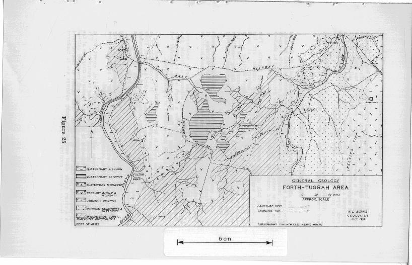
GENERAL GEOLOGY The basement rocks in the western part of the area are Pre
cambrian quartzite, garnet-muscovite-gral!hite schist, and ultrabasic rock, with strongly developed axial plane foliation striking generally north and dipping steeply to the west.
In the east the main rock type is a fine siltstone with shaley ,parting and occasional fossiliferous, conglomeratic bands, interbedded with tough, coherent, coarse siltstone near the reservoir, and soft, friable, felspathic sandstone, white clay and coal at Tugrah and on the Don Hill. These Permian rocks are separated from the Precambrian in the west by a Tertiary normal fault dipping east at a shallow angle and largely concealed beneath a superficial cover of Tertiary rocks.
The Tertiary rocks are terrestrial sediments, basalt agglomerate and basalt, at least .50,0 feet th ick in places. The best section is at the Ballamacargy Falls, where the sequence runs up from Precambrian garnet-mica schist through five feet of an incoherent boulder bed, five feet of coarse, friable sandstone, 12 inches of a volcanic white clay containing basalt bombs to about 30 feet of agglomerate and a hackly jointed zeolitic vesicular basalt. The basalt boulder bed outcrops sporadically through a wide area as a quartzite conglomerate, presumably locally silicified by superheated steam from the lava. The dolerite outliers on the map are fossil talus resting on Precambrian.
The main basalt type is hackly-jointed, vesicular, and caps the divide. This is underlain at Fulton Park and Forth by an agglomerate of variable thickness and patches of coarse-grained rock, or dolerite, which may underlie the rest.
•
•
• •
•
v
l 5cm
/
GENERAL GEOLOGY
FORTH-TUGRAH AREA 20 40 CHNr
APPROX . SCALE
LANDSLIDE HEEL .... .. ... .. .. . .... ... .. .---
LANDrLlDE TOE .... . ...... . ..V'
TOPOGRAPHY' UNCONTNOLLED AENfAL /tIOSAfc.
K. L BURNS GEOLOGIST
JULY f 354

124 ENGINEERING GEOLOGY.
The basalt is deeply weathered especially on the higher ground, and this distribution may mean that the deeply-weathered areas are remnants of a once-extensive surface sheet which has been removed in the neighbourhood of active streams. Where the soil profile is well developed a ferruginous laterite occurs; this is shown as a separate rock type where it is sufficiently abundant, althoilgh a soil map would probably show a wider distribution.
Alluvium is confined to the vaJIeys of the Forth and Don Rivers, and consists chiefly of boulder beds and fine silt.
GENERAL EXCAVATION CHARACTERISTICS
The alluvium of the river flats is largely soft silt in the Don River and boulder beds in the Forth, and excavation should be easy. However, immediately below the northern-most pumping site a quartzite bar no more than 100 yards wide may be encountered at shallow depth, and excavation through this would require blasting.
The bulk of the excavation will be in basalt or laterite. This is deeply weathered above about the a.5D--foot contour, and the weathered material, including the "rotten" bedrock, is at least 30 feet thick on the high ground. Near the Bass Highway on the northern routes a deep cut to road level at the crest of the divide should .present no difficulty. A reliable guide to digging conditions is the number of basalt boulders turned up in ploughing, and over a large area of this country there are none.
Solid, unweathered basalt is exposed in the banks of active creeks on the flanks of the divide, especlally along the Bass Highway at F orth. Basalt boulder deposits occur in scree slopes and landslide toes, where the soil has been removed by seepage.
The Permian rocks in the Tugrah valley are deeply weathered, t he conglomerate bands to gravel and the siltstone to friable clay. These should excavate easily except for a tough layer of coarse siltstone about halfway between the Don River and the reservoir but this probably occurs broken into boulders at pipeline depth.
The Precambrian rocks to be encountered are schist and quartzite. Generally only the quartzite outcrops. It is extremely tough and excavations require blasting. Similar to this are small areas of sub-basaltic quartzite conglomerate. which are not shown separately on the map, but are included with the Precambrian. Postholes in this material for the new H.E.C. power line had to be b1asted.
The schist weathers more rapidly than the quartzite and should excavate easily. The flanks of the hills of Precambrian rocks carry abundant loose scree, which will be easy country in schist but more difficult in quartzite as outcrops ar~ more frequent.
The northern route will encounter only schist, except for a possible quartzite bar beneath the alluvium near the pumphouse. The southern route win commence in schist and encounter quartzite at the crest of the hill. The extreme southern route will encounter patches of quartzite ,aU the way to Tugrah. The extent of cleared land is a rough guide since most of the rocky outcrops are in timbered or bracken-covered country.
•
I
(
•
•
•
•
•
•
•
ENGINEERING GEOLOGY. 125
STABILITY OF HILLSLOPES General
One of. the factors in favour of abandoning the present Paloona line is the urgent requirement of diversion to avoid troublesome ground. Unless the Forth scheme eliminates these dangers, one of the advantages of this new scheme will be lost.
The ripeline is but one unit in a scheme of which the completed value wiI be of the order of £200,000. If an area ,proves troublesome after completion of the pipeline and the pipeline requires diversion, the cost of this, or the siting of the bypass, may be such that if foreseen, it would weigh heavily in favour of an alternate layout of the whole scheme.
For these two reasons, as well as the direct cost of repairs, and loss of use during repairs, it is essential that the line be guaranteed free of slippage in the practical life of the scheme.
Known Unstable Slopes
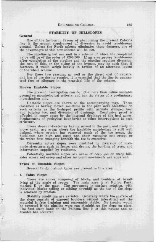
The present investigation can do little more than define unstable ground on morphological criteria, and has the status of a preliminary investigation only.
Unstable slopes are shown on the accompanying map. Those classified as having moved sometime in the past were identified on such criteria as the S-shaped profile with arcuate slumped heel and bulging toe, and diversion of drainage. Conclusive proof is afforded in many cases by the internal drainage of the heel zones, displacement of geological boundaries or other interruptions to rock structure.
Those slopes indicated as having moved in the past, and likely to move again, are areas where the landslide morphology is still well defined, where erosion has removed much of the toe zones, the hee]slopes are high and steep and show excessive soil creep, or the water flow emerging beneath the toe is excessive.
Currently active slopes were identified by diversion of manmade structures such as fences and drains, the bending of trees, and information su,pplied by residents.
Potentially unstable slopes are areas of deep soil on steep hillsides where soil creep and other incipient movements are apparent.
Types of Unstable Slopes Several fairly distinct types are present in this area.
1. Talus Slopes These are slopes composed of blocks and boulders of basalt
lying at the angle of repose. The main area is at Fulton Park, marked E On the map. The movement is surface rotation, with individual blocks rolling or sliding downhiJI as the toe of the slope is removed by erosion. '
Stability conditions are variable. Generally where the surface of the slope consists of exposed boulders without interstitial soil the material is free draining and reasonably stable. No trouble would be expected if the pipeline were run straight up the slope on piers. The first steep bank on the Paloona line is of this nature and no trouble has occurred.

Scm
v
"
~ Iv -,
A.' \ .... - ... __ - ..... 1
LEGEND ...
LANDSUDE Hen. • 'l
Wl1/iftMSHWiYJIlJOL A
PROPOSE/) STORAtiE_ .•
DEPT. Of' MINES
~
UNST ABLE SLOPES
FORTH - TUGRAH AREA 2p JP CHS.
CIIRREIm.Y ACTIVE ~ ACTIVITY CEASED . • -c::J LIABLE ro RENEWED MOVEMENT ••• HIII POTENTIALLY UNSrAi1LE r:==J
TOPOGRAPHY: UNCONTROLLED AERIAL MOSAIC
K.L BURNS GeOLOGIST J ULY 16&6

•
•
ENGINEERING GEOLOGY. 127
However, in many eases these slopes are covered hy deep soil. imperfectly drained, and they are therefore distinctly hazardou-s. If the crossing of area If E H on the southern route is kept as short and direct as possible there will be no difficulty. This route as surveyed is unfortunately sited in this respect and the amount of correction required is shown on the plan as a dog-leg at the top of the hill.
2. Shear Zones In this area are several zones where a group of deep deforma
tional shear sHdes occurs together, forming a distinct landslide zone readily detectable on the aerial photographs. The originally proposed reservoir sites at Kelcies Tier were abandoned because they were situated in a shear zone of this type. The slides have well-defined arcuate heels, convex toes and a formed slip surface related to the rock structure. Volumes for each slide are of the order of 500,000 cubic yards .
There are two important shear zones crossed by the northern route, zone If A " at Forth, and zone If B .. on the Don Hill.
Zone A This is a large zone developed in basalt and its direct cause
is undercutting by the Forth RIver. The original sliding surface may have been a thin layer of saturated white clay exposed about 100 feet above the river at the northern end, but in the central portion of this zone continued movement has occurred on a slide surface below this, and emerging helow river level.
InJ'arts of this zone the landslide morphology has been completely subdue by erosion, but in the parts shown as liable to renewed movement it is quite fresh. with internally draining heels, considerable waterflows at the toes which have winnowed the soil from boulders, and soggy marshy ground on the foreslo.pes.
Portions of this zone are active. There are minor movements on the steep heel and toe banks, and a considerably larger slip at river level. This has moved several times in the last few years, dislocating the road. Although the roadway has been rebuilt, no attempt has been made at drainage and continuing movement is certain. Movement in the near future of adjacent areas to the north and south is highly prob.·ble.
This slide is a small one on the toe of the major shear zone, and may be a preliminary to movements higher up the slope. The possibiJity of progressive fail~re is very real, commencing at the toe and migrating uphill to include the whole slide zone.
Zone B III This is a set of deep deformational shear slides in Permian silt-
stone covered with a thIn layer of basalt, and thought to be moving on a surface formed by soft clay interbedded with the siltstone. The slip surface intersects the bed of the Don River. These slides have a very long history, because since their inception the river has ('ut away large portions of the toes-Miners Row alluvial flat is cut into
• the slides-and the meander belt has shifted away. This .places the major movement at roughly a thousand years ago. In one place a remnant of the toe occurs on the east side of the Don, which suggests that this movement actually dammed the river.
•
128 ENGINEERING GEOLOGY.
Portions of this zone are again very active-where the toes are being actively undercut there occur numerous small slides into the river, and in one place there is a significant rotation of trees over several acres. This movement is local, probably due simply to the steep bank into the river formed by undercutting, but whether it heralds progressive renewed failure of the whole zone is difficult to determine. However, large-scale movement of the western portion is considered to be imminent-that is, the area near the mouth of the creek at the western end of Miners Row.
This zone has a very steep arcuate heel with springs emerging toward the base of the bank. It is formed in siltstone but mantled with a thin layer of basalt which conducts the water flow to the base of the slope. At the western-most farmhouse a spring emerges halfway up the slope. Failure of this bank is a possibility, and as well as dIslocating the pipeline on the northern routes it could threaten the Bass Highway.
Zone C This is a deep deformational shear zone in basalt, the slip
surface emerging somewhere near river and road level. This is considered dangerous, as careful examination shows bowing of the road cutting and shallowing of the road drains, suggestive but not conclusive of recent movements.
At river level the unstable zone is split into two by a quartzite l'idge outcropping just below a low gravel island in the river. The intake works should be anchored to this quartzite on the western bank, as the outcrops just upstream are basalt which is probably not in situ.
3. Intermediate Slides Slides of intermediate size, with volumes of the order of 20,000
to 50,0.00 cubic yards, and moving on slopes of 10-20 degrees, are fairly common. The active slides in the centre of zone A, and on the banks of the creek in zone D, are of this kind. A related type caused the damage to the Paloona line in the valley of Melrose Creek. These slides occur in deep soil in both Permian rocks and basalt.
One of the dangers in zones of deep deformational shear, A and B, is that this smaller type will develop on the steep slopes resulting from the large-scale movements .
. The movemerit on these intermediate sl ides is definite-subsidence of the heel, bulging of the toe, and transcurrent movement of the sides. The subsidence and heave can be partly accommodated in pipelines run straight down the slope.
These slides are a major problem in that they can occur without warning, a number of them scattered over a slope at once as at Paloona, and movement may be repeated almost seasonaIIy. However, they are confined generally to known landslide zones, and to slopes steeper than about 1tS degrees. Their relationship to soil cree,p may be significant.
4. Soli Creep Soil creep, or surface movement of the soil and turf, is common.
It begins on slopes of about 15 degrees, and is most marked on slopes steeper than 20 degrees. Usually the creep is emphasised by the
,
•
•

ENGINEERING GEOLOGY. 129
utilisation of the platforms by farm animals, and then the creep shows as a series of sheep tracks contouring the hillside. Associated with this on slopes steeper than about 20 degrees are small landslides with volumes of the order of 100 cubic yards .
. Soil cre~p with its accompanying small slides is not in itself an engineering hazard, but it is thought that its presence in indicative of the state of the subsoil. The intermediate slides occur on slopes where soil creep is apparent, and it is not unlikely that intermediate slides and soil creep result from similar subsurface conditions. The presence of creep has therefore been used as a guide to poten,tially unstable ground.
ALTERNATIVE PIPELINE ROUTES
Alternative pipeline routes are shown on the accompanyin~ map and are designated It northern route", It extreme northern route " and so on, as a matter of convenience.
The key factor in location is the height of the highest point reached. whIch is about 400 feet above sea level on the northern routes and the extreme southern route and slightly .higher on the southern route.
The to,p of the Forth-Don divide is rolling country and is generally stable, but the main difficulty is in determining a route on to the divide from the lowlands on either side. Generally, the further north the route the steeper the flanks of the divide, and the more dangerous the ascents. Solely from the point of view of stability the most Ruitable is the extreme southern route, the least suitable is the northern route, while the southern and extreme northern routes are comparable. Pipeline routes further north, beyond the map, would probably be hazardous.
Extreme Southern Route
This is approximately 4.3 miles long. The pumphouse site and route of the first leg are quite flexible. This route gives a safe and gradual climb on to the divide, a low crossing, and a safe descent. Not a single known dangerous slope is crossed.
Southern Route This is about 4.1 miles long. It suffers from a s teep ascent
immediately behind the purnphouse, and a fairly high crossing of the divide where it must sidle a slo.pe in deep soil. The descent is gradual and safe, while the ascent could be made on piers over the short length of talus, and the divide crossing could be made safe by drainage provisions concurrent with construction.
Northern Route This is about 4.2 miles long. It suffers from a steep ascent behind
the pumphouse, but gives a fairly low divide crossing, is well placed with respect to subsidiary works, lind is readily accessible. However, it is the worst possible route with regard to landslides since it crosses two large shear zones which are active in their toes, and although ancient, are not necessarUy free from renewed failure. In addition the zones have numerous steep banks liable to failure on a smaller scale.
130 ENGINEERING GEOLOGY.
While general movement of these zones is perhaps unlikely within 100 years, small slides quite c8J)able of disrupting the pipeline are proceeding in the toes and are possible on higher slopes.
If this route is chosen it must be preceded by careful and possibly ex'pensive detailed investigation of the §i1ide areas. It is considered that with care, and baving regard for the life of the scheme, a safe route could be found through these zones. A suggested route is marked on the map. However, no route should be approved without a previous demonstration of a high factor of safety of all slopes which are crossed.
Extreme Northern Route This route is located to fallow much the same path as the northern
route but to avoid the slide zones. It is the longest route, being about 4.9 miles long. The double crossing of the Forth River is unavoidable since the pumphouse and first leg must be located away from the slide zone C, and the second leg can only avoid zone A by crossing to the western bank. Diversion around zone B is easiest on the northern side.
RECONDKENDATIONS General
• ,
<
As the central, essential unit of a big scheme upon which a fairly large population will de.]2end for hea1th, and many people for employment, the pipeline should be routed to be as free from danger as possible. Development of instability during or after construction may require ultimate relocation, the cost of which could be considerable and which, if foreseen, would have led to the ado,pting of an alter- " native layout. The only route regarded as entirely safe is the extreme southern route.
However, the scheme has a limited life, and landslide zones are sometimes stable for long periods-for instance, there is evidence that the deep shear zones, A and B, are temporarily stable from the point of view of deep-seated movement. This stability, geologically only temporary, may be such as to warrant, from the point of view of a short-lived engineering scheme, being regarded as permanent. Therefore if considerable savings in costs can be effected by crossing slide zones, it may be economically worthwhile to make detailed assessment of their degree of stability.
If any slope marked on the plan as unstable is to be crossed, the stability of the whole slide zone must first be determined, then within this zone the danger of local movements must be investigated to the stage of the computation of a factor of safety against sliding for each slope. Even if all the slopes have <8 high safety factor, precautions must be taken in construction to .prevent causing changes which will alter this factor.
Specific
Specifically these recommendations may be implemented as follows:- .
1. The major unstable areas lettered A to E must be avoided if at all possible.

ENGINEERING GEOLOGY. ,31
2. If one of these is crossed, the following pre-construction measures are advised:-
(a) Preparation of a detailed map of the whole slide zone, particularly zones A and B, contoured to at least a 10-foot interval. Then, if necessary, drilling or shaft sinking, the aim being to locate the surface of sliding and estimate the safety factor for renewed deep shear movement.
(b) If the slide zones as a whole have a sufficiently high factor of safety, then all slopes steeper than 10 degrees must be closely investigated, and a factor of safety against small-scale slides computed for each slope. If the slopes are unstable then stability must be provided by such measures as drainage, or the line must be constructed to absorb movement.
3. If an unstable area is crossed, and these investigations show a sufficiently high factor of safety, then precautions during construction will still be necessary, involving inspection and testing while the excavations are open, routing the line to run straight up and down the slope, and concurrent provision of adequate drainage of the landslide heels, possibly by back-filling the excavation with suitable material.
The advantages to be gained by crossing unstable areas must be balanced against the cost of these precautions which nre considered to be the minimum necessary.
SUPPLEMENTARY REPORT Introduction
The route finally adopted for the new pipeline to su,pply Devonport and environs is the northern route of the preceding report. Since this route crosses two landslide areas, consideration has been given to the possibility of movements on the pipeline route during the life of the scheme.
Landslide Areas
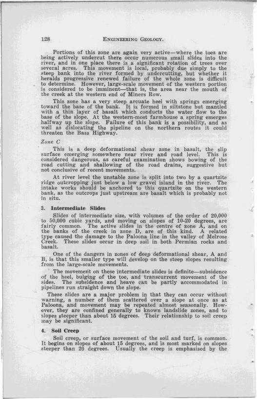
The two major areas are the Forth Hill, on the east bank of the river just south of the township, and the Don HilI, overlooking the Don River at Tugrah. These are the zones A and B of the earlier report. The geological information . obtained is compiled in a plan for each area.
Don Hill
The bedrock here is Permian fossiliferous conglomerate s iltstone, overlain by sandstones of the Mersey Coal Measures and pebbly sntstones corresponding to the Woodbridge GroUJl. These rocks <lip steeply east, due largely to drag-dip on a major Tertiary fault a shol't distance west, so that they outcrop as narrow belts with a N.N.W. strike. The belt of Mersey Coal Measure passes through the western side of the slide zone, and it is probable that the slid~s moved on a bedding surface, possibly a coal measures clay or shale, which dips east into the Don River. '

Scm ~I
DON HILL LANDSLIDES q~ ____ ~6PLO _____ "~~OOFT.
ALLIJVIIJM _ ___________ ~
BASALT TALIJS ___ __ __ ~ PERMIAN 7:4LIJS _______ E:::J TE:RTIARY BASALT- ______ D:] PIPE: UNE:(Wilh fool0!1')-- ---.!. .. ~
LANDSLIDE: HE:E:L _____ 3 ACTIVE: LANDSLlDES ____ "B
V v
v v v v
v
v v
v
v v
(
SILTSTONE: ____________ ~_E::3
PERMIAN SANDSTONE (Meru/Coal M"."",.".slt::::::"': :1 SILTSTONE: _____ ____________ ~
SECTION XY
Figure 27
K.l..L1U!rNS GEoLOGIST
HISS

ENGINEERING GEOLOGY. 133
The landslide toes appear truncated by the river terrace, which means the movement predates the present meander pattern of tbe Don River; i.e., it occurred some thousands of years ago. The landslide morphology has been somewhat modified by subsequent erosion.
The direct cause of slwpage is undercutting by the Don River and since this process has now largely ceased, the slides are considered stable. The only activity noted consists of small slides where undercutting is stilI effective, but this is away from the pipeline route. and will not affect it.
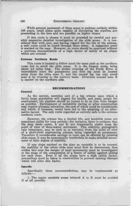
Forth Hm This landslide zone is entirely in basalt. The morphology is fresh
()nly in the southern part, but even here it has been modified by .ordinary processes of erosion, so that the movements must have ,occurred a long time ago.
The defineg slides appear to be moving on a surface about 100 feet above the river, and there are many springs issuing at this height. In the northern part, a · small area of white clay occurs ()n a bench at this level, so it is likely that the slides are moving ()n this clay bed.
Present movements are confined to a small slide on the river bank where a small creek supplies excessive amounts of water into the slide area. There is no indication of recent movement anywhere -else.
4Jonclusions The major slide zones are ancient, and are probably related,
though perhaps indirectly, to a period of higher sea level about 6,000 years ago. Observations throughout the district show many slides formed in this period, most of them due directly to undercutting by wave action. Nowhere is there evidence of large-scale modern movement-the modern landslides aTe confined to small slides on the steep slopes remaining after the earlier movement.
Renewed large-scale movements of the slide zones are therefore ruled out; the remaining possibility is that there may be small slides where the pipeline crosses the old landslide heels. The areas concerned are from 3,000 to 3,800, 18,200 to 18,400 and possibly in the deep creek from 5,700 to 6,200 (pipeline footages). Although there bas been movement in the past, in these areas this has now ceased. There are no abnormal drainage conditions and the existing slide surfaces are lubricated mainly by rain-water passing through to join the water table which is probably usually below the slides. The pipeline crosses these places in short steep rises so that it will have strength to resist small movements. It is therefore considered that these areas, although they are formed slides, are not dangerous slopes to cross.
Careful consideration was given to the possibility of precautionary measures concurrent with pipeline construction. As pointed out by the Senior Geologist, Mr. T. D. Hughes, the only effective drainage would be by adits, and as there is not excessive water present to require drainage, this procedure would be pointless. The existing landslide heels, although closed depressions are free draining, and do not store water ever after heavy rain, so the formed slip surfaces are acting as drainage channels.

FORTH HILL LANDSLIDES 0 I
V V V
V V
V V V
V " V
V V (~-;~--~\_ ............ ---
'\, q
" ·cl;;y "
. H. ~C.
~.'
V
V
ALLU VIUM __ _ _ ____ _
BASALT TAL US_ ___ ~ TERTIARY BASAL7: ___ ~ PRECAMB. Schist .. "f3ile. _.~ PIPE LINE (iV!fh fOMRge) __ ~2'
LA NDSUDES_ _ _ ___ E:3 ACTIVE LANDSLlDES __ _ ,~
V
coo 1200FT. t I I
N
BASS ~ .
---..... " ~ .....
..... V V '-..... t-III'At._- .... --
..... -........... t-4~~-- , V V ~ ... V V
V V V V V 73~7
V V V
V V
V V V V
V V " V V V
V V "":"',' V V
V V V Line
4!J.33 V V
V V V V
V V V V
V V V V
V V V V
V V V V
V V V V
V V V
3" V
;7 V f · V 200'
100' V
-v-mh.iim~v o V 3075' V V
3000' PIPELINE Foor,f6£
SECTION AB
V 'pon
250S?? ~ 200t========L ______________ _ --.J
SECTION CD
? I~OFr
K . L . BVII.VS C3EOLOGIST
/9S.
Figure 28
5cm
:
•
..

ENGINEERING GEOLOGY. 136
Recommendations The route adopted, although crossing formed slips, is reasonably
safe for pi,peline construction. A check should be made during construction to ensure no new slips are caused by the excavation. Care should be taken to prevent leakages in the portions 3,000 to 3,8~l 5,7~0 to 6,200, 18,200 to 18,400 (pipeline footages). Permeable bacKIllling in these areas is unnecessary and even harmful as it will increase the amount of rain-water delivered into the formed slides.