1200 West Box Elder Creek Bridge - wfrc.orgwfrc.org/Programs/TransportationImprovementProgram/2018_2023... · The pav對ement width ranges from 60 feet to 24 feet. It is planned to
27
Brigham City – 1200 West Box Elder Creek Bridge - Widening Project Type – Reconstruction 550 North to 650 North To widen an existing bridge on 1200 West over Box Elder Creek that will accommodate increasing traffic volumes from growing industrial and commercial uses. The project is part of planned improvements for 1200 West which will provide a north/south corridor between SR-13 in Brigham City and SR-315 in Willard. Project Cost – $ 1,750,000 Funds Request – $ 1,582,113
Brigham City – 1200 West Box Elder Creek Bridge - WideningProject Type – Reconstruction
550 North to 650 North
To widen an existing bridge on 1200 West over Box Elder Creek that will accommodate increasing traffic volumes from growing industrial and commercial uses. The project is part of planned improvements for 1200 West which will provide a north/south corridor between
SR-13 in Brigham City and SR-315 in Willard.
Project Cost –$ 1,750,000
Funds Request –$ 1,582,113
Presenter
Presentation Notes
The project is needed to allow continued industrial and commerical growth on the 1200 West corridor. The current bridge restricts the capability to widen the corridor to a 5-lane facility. The 1200 West corridor is the only major north/south corridor planned between US-89 and I-15. The corridor and associated bridge widening have been on Brigham City's Master Plans for many years and have been recommended by studies. Much of the property acquisition has been completed for the project. The 1200 West corridor is supported by neighboring communities.
Brigham City – 1200 West Roadway Extension – New ConstructionProject Type – Capacity
Construction of a mile of 1200 West between Forest Street and SR-91. The purpose of the project is to further the corridor connection between the 1100 West / SR-91 intersection and Forest Street.
Forest Street to 750 South (Phase I)
Project Cost –$ 6,059,100
Funds Request –$ 5,532,361
Presenter
Presentation Notes
The transportation needs are currently served by three interstate accesses, a regional airport and a heavy rail system. The westerly area of the City, however, is deficient in adequate roadway infrastructure to support future growth. The 1200 West corridor will provide the main north/south transportation corridor for the western part of the City. It begins with Watery Lane on the north end of the City at SR-13 with a 60-foot paved roadway and ends with a dirt road just past the city sports park. The pavement width ranges from 60 feet to 24 feet. It is planned to continue the corridor and connect to the new 1100 West 1100 South intersection. The overall project will be separated into phases/projects. This project is to widen the 24-foot paved roadway from Forest Street to the end of the current dirt road south of the city sports park. The city is in the process of purchasing the right-of-way and is now looking for funding assistance for completing the construction for this project.
Perry City – Highway 89 Pedestrian Overpass – New ConstructionProject Type – Bicycle/ Pedestrian - Other
Project Cost –$ 5,672,700
Funds Request –$ 5,172,121 The project will be to construct an overpass across Highway 89 at
approximately 2500 South.
West side of Highway 89 to East side of Highway 89
Presenter
Presentation Notes
This overpass will facilitate improved pedestrian and bike traffic to cross highway 89 in a safe and efficient manner. A significant portion of Perry's population resides on the east side of Highway 89 while both schools are located on the west side of highway 89. This overpass will allow for a safer route to school, and enable pedestrians, and bikers, to safely go between neighborhoods on both sides of highway 89. This will also encourage and facilitate alternate transportation within Perry City.
Farmington City – East Park Lane ROW Acquisition Project Type – Right of Way
326 West Park Lane
Project Cost –$ 169,800
Funds Request –$ 158,305
The north side of SR 225 is fully improved from Main St. to Lagoon Dr. except for a 100' gap which requires asphalt, curb & gutter, sidewalk and additional ROW at 326 West Park Lane. The project will purchase ROW on the north side to install
the improvements at a later date.
Presenter
Presentation Notes
The State is committed to investing millions now in providing pedestrian access across Park Lane. This small project will ensure that a good number of pedestrians and bicylists will use the pedestrian overpass facility.
Farmington City – SR-106 (Main Street) – Reconstruct & Minor WideningProject Type – Reconstruction
The proposed project is intended to improve drainage and add pedestrian facilities to the section of SR-106 (Farmington Main
Street) between Park Lane and Shepard Lane on the west side of the road. The project will include storm drain, curb and gutter, sidewalk
and pavement widening to allow for standard shoulder width.
Park Lane to Shepard Lane
Project Cost –$ 1,986,400
Funds Request –$ 1,851,921
Presenter
Presentation Notes
This project will provide improvements to a critical link between the north and south communities of Farmington and will greatly enhance the ability for emergency vehicles to serve both communities linked by this route. This road currently has little to no existing shoulders and no drainage improvements along this section. Additionally this route is a part of UTA's established bus route. Improving this route provides a safe place for buses to pull off and for riders to safely board and unload from the bus. Improving this road also provides connectivity for pedestrians, and bicyclists. Widening the shoulders and adding a sidewalk, provides a safe place for pedestrians and bicyclists where currently there is nothing. Lastly this project is identified as a "safe route to school".
Project Cost –$ 5,278,000
Funds Request –$ 3,000,000
Kaysville City plans to reduce traffic congestion and increase safety and mobility for pedestrians and bicyclists by installing traffic
signals at the intersections of Main St/Mutton Hollow and Fairfield/Mutton Hollow. These intersections are on critical
transportation corridors to residents, businesses and schools.
Main Street and Fairfield Road
Kaysville City – Mutton Hollow – Intersection ImprovementsProject Type – Operations
Presenter
Presentation Notes
Increased traffic from growth and changing traffic patterns has created the need for improvements to the Main Street and Mutton Hollow intersections. The needed improvements include a signal for traffic flow, safety, and mobility. The intersection of Main Street and Mutton Hollow intersection currently meets the requirements to warrant a traffic signal. The Fairfield and Mutton Hollow intersection will meet warrants within the next 5 years. Improving traffic flow and safety is a vital priority because of the facilities connections to schools, churches, residents, and existing commerce. All of the roads are on the functional classification map as Collectors or above and are critical transportation corridors. Kaysville is requesting $3,000,000 rather that the full project amount. Kaysville will construct both signals and as much of the road as possible with this funding. Kaysville will then complete the remaining portion of the project with their own funding as a separate project.
Kaysville City – Sunset Drive – Reconstruct with Minor WideningProject Type – Reconstruction
Old Mill Lane to Western Drive
The project includes curb, gutter, sidewalk, and turning lanes with the widening of Sunset Drive from Old Mill Lane to Western Drive.
Reduced risk, improved safety, and sidewalk consistently are a product of this project which is located in an area where there are
3 schools and heavy pedestrian and auto traffic.
Project Cost –$ 3,432,400
Funds Request –$ 3,200,000
Presenter
Presentation Notes
The number one issue driving this project is safety! Sunset Drive is the primary access to 3 schools – a junior high, elementary, and a charter school. Many youth and children walk this stretch of road daily being that it is their only – so called – safe route to school. Sidewalks are inconsistent with long stretches between sidewalks in some areas and small gaps here and there in others. The shoulders of the road are narrow and in the winter months, often covered in snow leaving children to walk right up beside the road. Lots of traffic is generated just getting kids to school and back because of the unsafe walking conditions. This project will fill in the gaps of curb and sidewalk and provide an actual safe route to school. It will allow for better traffic flow with new turning lanes at intersections, improve storm drainage, and will provide a safe, continuous, transportation corridor that accommodates both traffic and pedestrians.
Kaysville/ Farmington – West Davis Corridor – New FacilityProject Type – New ConstructionWest Davis Corridor to Shepard Lane & I-15
This project will construct a new road connecting the proposed Shepard Lane interchange on I-15 to the West Davis Corridor and
Sunset Drive. This new roadway will provide mobility and access to these two major transportation corridors. With this being a new
roadway, 200 North in Kaysville was used for the traffic data.
Project Cost –$ 10,833,600
Funds Request –$ 10,100,000
Presenter
Presentation Notes
The preferred alternative for the West Davis Corridor has been chosen, and within that alternative, an identified connection between I-15 and West Davis will need to be made. This project will provide that vital link between I-15 at the proposed Shepard Lane interchange and the West Davis Corridor near Sunset Drive. This project is shown on the RTP and will provide access and improve mobility and safety to Kaysville and Farmington Cities. Farmington and Kaysville Cities have been preserving a corridor for this project.
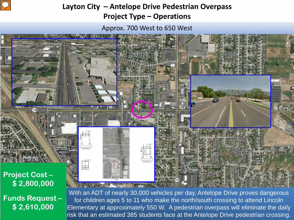
Layton City – Antelope Drive Pedestrian Overpass Project Type – OperationsApprox. 700 West to 650 West
Project Cost –$ 2,800,000
Funds Request –$ 2,610,000
With an ADT of nearly 30,000 vehicles per day, Antelope Drive proves dangerous for children ages 5 to 11 who make the north/south crossing to attend Lincoln
Elementary at approximately 550 W. A pedestrian overpass will eliminate the daily risk that an estimated 385 students face at the Antelope Drive pedestrian crossing.
Presenter
Presentation Notes
With an ADT of nearly 30,000 (2016) vehicles per day, Antelope Drive proves dangerous for children ages 5 to 11 who make the north/south crossing to attend Lincoln Elementray at approximately 650 W. A pedetrain overpass will eliminate the daily risk that an estimated 385 students face at the Antelope Drive pedestrain crossing. Nearby businesses and commuters will also benefit from this overpass as multiple restaurants and retail stor fronts are in close proximity to the crossing. Separating pedestrain traffic from vehicular traffic will reduce congestion, slow-downs, and back-ups due to reduced school speed zone and can reduce the number of pedestrain related accidents in the area.
Gentile and Layton Parkway to the West Davis Corridor
Construction of 2700 West from the West Davis Corridor (WDC) to Gentile Street and Layton Parkway from 2200 West to 2700 West
will provide greater access and improve traffic flow for the area as well as provide economic benefits for the surrounding community
by having additional travel routes to and from the WDC.
Project Cost –$ 15,921,100
Funds Request –$ 14,843,242
Layton – West Davis Corridor Connection – New FacilityProject Type – New Construction
Presenter
Presentation Notes
With the construction of the West Davis Corridor, the construction of 2700 West from the West Davis Corridor to Gentile Street and Layton Parkway from 2200 West to 2700 West are critical components of the transportation network for residents to access the West Davis Corridor. The connections will provide greater access, reduce out of direction travel, and improve traffic flow during peak times for the area as well as provide economic benefits for the surrounding community by having additional travel routes to and from the West Davis Corridor.
North Salt Lake – Main Street - ReconstructionProject Type – Reconstruction
Center Street to 350 North
This portion of Main Street is very old and is in desperate need of attention. Patching of the potholes has become a constant task and the asphalt is failing. The project is also needed to accommodate increased future traffic, as significant and rapid redevelopment is occurring in and
around this neighborhood.
Project Cost –$ 1,312,200
Funds Request –$ 1,223,364
Presenter
Presentation Notes
Main Street is a Minor Collector in North Salt Lake that connects to Woods Cross and West Bountiful, making this road particularly busy because it is handling local & regional traffic. It is used by many residents to access I-15 at 2600 South in addition to being used as a frontage road when I-15 is congested. Main Street experiences UTA and school bus traffic on a daily basis. Semi-trucks are restricted, but due to the vicinity of the industrial park there is still an occasional truck driving illegally on the road. The infrastructure is aging, as this neighborhood is our oldest in the City. It was last reconstructed 30 yrs ago, and the constant patching of the road is not resolving the problem of the failing asphalt. Main Street is a major connection into our developing Town Center and provides access to Hatch Park. The City is investing in this area of the City to ensure that the maintenance of our existing roads is given as much attention as the redevelopment of the Town Center.
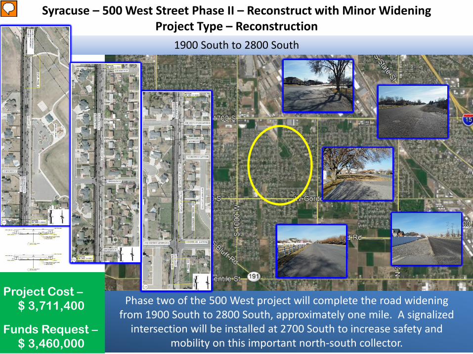
Syracuse – 500 West Street Phase II – Reconstruct with Minor WideningProject Type – Reconstruction
1900 South to 2800 South
Phase two of the 500 West project will complete the road widening from 1900 South to 2800 South, approximately one mile. A signalized
intersection will be installed at 2700 South to increase safety and mobility on this important north-south collector.
Project Cost –$ 3,711,400
Funds Request –$ 3,460,000
Presenter
Presentation Notes
This project will complete 500 West through Syracuse to allow for a North-South connection between Antelope Drive and the Layton Parkway. Layton is in the process of completing the final segment of this connection within their City. This project will install a traffic signal at the intersection of 2700 South to improve safety and mobility on this important multi-city collector and will help to ease congestion in the surrounding area. Syracuse City has already purchased a home and property in anticipation of the signalized intersection.
UDOT / Clinton – Dual Left Turn Lanes - Intersection ImprovementProject Type – Operations
2000 West (SR-108) at 1800 North (SR-37)
The 2000 West and 1800 North Intersection is extremely congested and will become even more busy as 2000 West is widened to 5-lanes and the new interchange at 1800 North and I-15 is constructed.
Project Cost –$ 3,000,000
Funds Request –$ 1,500,000
Presenter
Presentation Notes
This project will especially be needed when funding is acquired to widen both of these state routes. Both are currently on the long range plan.
West Point – 300 North – Reconstruct/ Minor WideningProject Type - Reconstruction
2000 West to 3000 West
Project Cost –$ 3,787,200
Funds Request –$ 3,508,431 Widen to a three lane section and install curb, gutter and
sidewalk. Provide turn lanes at all intersections.
Presenter
Presentation Notes
300 North is the main road in West Point City and carries more traffic that all other roads in the City. This is currently a state highway but will eventually become a local road when SR 193 is extended. It will be necessary to reconstruct sections and to widen the entire facility to accommodate current traffic volumes and to avoid major conjustion in the near future. 300 North is a very high traffic road and is the main corridor into West Point City at the present time. It carries a great deal of traffic commuting to Hill Air Force Base and to I-15. Our general plan originally called for this road to be widened to a 5 lane facility, however, the proposed extension of SR 193 will reduce the traffic on 300 N to the point that only 3 lanes will be necessary. 3 lanes can fit within the existing right-of-way, which makes this a very cost effective project.
Woods Cross – 800 West 1500 South – Signal ProjectProject Type – Operations
800 West and 1500 South
800 W and 1500 S provide access for pedestrians, bicyclists, and vehicles to schools, Hogan Park, local businesses, City Hall, and other community buildings. Woods Cross plans to reduce traffic congestion
and increase safety and mobility for all users by installing a traffic signal at the intersection of 800 W and 1500 S.
Project Cost –$ 976,100
Funds Request –$ 910,000
Presenter
Presentation Notes
In an effort to reduce traffic congestion and increase safety for all users on 800 West and 1500 South, Woods Cross City plans to install a traffic signal at the intersection of 800 West and 1500 South. This signal will replace the current 4-way stop intersection. This will allow pedestrian, bicyclists, and vehicular traffic to maneuver through the intersection with increased protection and safety. A traffic study has been completed which recommends the installation of a signalized intersection. As critical transportation corridors, 800 West and 1500 South are both classified as Collectors streets on the Functional Classification Map providing essential access to schools, Hogan Park, local businesses, City Hall, and other community buildings.
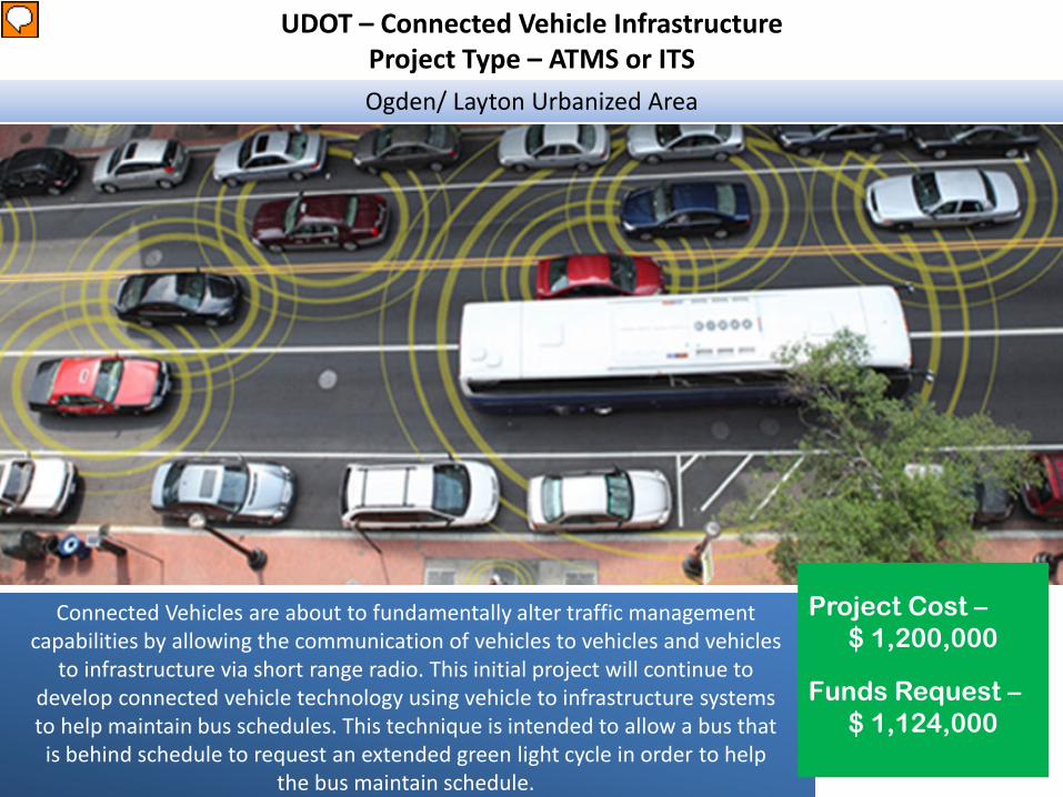
UDOT – Connected Vehicle InfrastructureProject Type – ATMS or ITSOgden/ Layton Urbanized Area
Connected Vehicles are about to fundamentally alter traffic management capabilities by allowing the communication of vehicles to vehicles and vehicles
to infrastructure via short range radio. This initial project will continue to develop connected vehicle technology using vehicle to infrastructure systems to help maintain bus schedules. This technique is intended to allow a bus that is behind schedule to request an extended green light cycle in order to help
the bus maintain schedule.
Project Cost –$ 1,200,000
Funds Request –$ 1,124,000
Presenter
Presentation Notes
Connected Vehicles are the future and evolution for the use of high technology in transportation. The Current Director of Transportation, Mr. Calrlos Braceras has made a priority of advancing connected and automous vehicles technology along with decreased travel times within the urban areas. This project creates a pathway to obtain those priorities and benefits urban Air Quality simultaneously. It is known that decreasing vehicle idle time at traffic signals improves air quality and, is one of the prime objectives within the field of Traffic Operations. The Vehicle to Infrastructure system that is being proposed advances the Director's objectives while providing an air quality benefit by allowing buses to pass through signal controlled interstections if needed to hold schedule and reducing idle time for buses.
Harrisville City – West Harrisville Road – Reconstruct w/ Minor WidenProject Type - Reconstruction
Highway 89 to 750 West
Project Cost –$ 3,797,500
Funds Request –$ 3,423,872
This project will reconstruct and widen to a consistent 3-lane facility. Existing facility has one lane each direction with an inconsistent width of pavement. This project will accommodate a center lane for turning movements and
increase safety and capacity.
Presenter
Presentation Notes
West Harrisville road is an east-west corridor that connects Harrisville and Farr West City. It is one of the two main entrances into the Weber County Fairgrounds. Though it has sections of wider pavement it's capacity is limited because of smaller sections where only two lanes have been completed.
North Ogden City – 450 East / 400 East – Widening Phase IIProject Type - Capacity
Project Cost –$ 10,508,400
Funds Request –$ 7,288,162
To widen the existing roadway from one lane of travel in each direction to two lanes in each direction. This is a major collector street in the City that receives and distributes traffic from other
collector/arterial roads and does not currently provide the level of service necessary.
Elberta Drive to 3300 North
Presenter
Presentation Notes
The project is needed to widen Washington Boulevard and to improve current and future traffic flows. The street is a major collector and will eventually connect to Skyline/Mountain Road which will bring more traffic from I-15, Highway 89 and Pleasant View City. Currently there is only one lane of traffic in each direction with a median turn lane north of 2600 North which causes a bottle-neck effect on travel from the intersection of Washington Blvd./2600 North. This expansion is critical for future traffic flow in North Ogden and is a Phase One project in the Utah Unified Transportation Plan. The City has already obtained funding through the Weber Area Council of Governments (WACOG) to help fund the property acquisition required for this project.
Ogden City – 20th Street - ReconstructionProject Type - Reconstruction
Monroe Blvd to Harrison Blvd
Structurally, the pavement is distressed and is rated as poor. Severe cross-slopes, deep gutters and antiquated storm drain inlets are out of standard and are liabilities. 20th is a "gateway road" into
Ogden, an improved roadway would reflect well on the City.
Project Cost –$ 5,471,100
Funds Request –$ 4,654,508
Presenter
Presentation Notes
Linking Harrison Bl, Monroe Bl and Washington Bl to I-15, 20th Street is one of the most traveled streets Ogden. There are many issues this project could resolve: 1) Increase separation between on street parking and traveled lanes 2) Install right turn pockets to improve capacity and safety 3) Add pavement width to install TWLTL- which will improve capacity reduce rear end accidents 4) Resolve emergency access on "old" Harrison 5) Improve intersection alignments and remove antiquated storm drain inlets 6) Improve pedestrian corridor along 20th Street 7) Resolve excessive crown and small corner radii 7) Raise eastbound approach at Harrison improving overall intersection visibility 8) Install bike infrastructure
Plain City – North Plain City Road – Reconstruct with Minor WideningProject Type – Reconstruct
3300 West to 2800 West
This project will widen North Plain City Road between 3300 West and approximately 2800 West to the city boundary. The project will include
adding shoulders, reconstructing the existing asphalt section, and adding road improvements such as curb, gutter and sidewalk.
Project Cost –$ 7,360,800
Funds Request –$ 6,862,474
Presenter
Presentation Notes
The proposed project is to widen and reconstruct North Plain City Road from 3300 West to approximately 2800 West. The project would improve mobility and safety for bikes, automobiles, and pedestrians. Plain City is experiencing rapid growth along this corridor and will continue to result in increased traffic. The pavement width is very narrow and does not have any improvements to provide safety. Currently there is not a safe walking path for pedestrians. Weber School District owns property for a future elementary school in the area. The traffic to the school will access the school grounds by traveling on North Plain City Road.
South Ogden – 40th Street & Chimes View – Reconstruct w/ Minor WideningProject Type – Reconstruction
Riverdale Road to Washington Blvd
Project Cost –$ 4,745,200
Funds Request –$ 4,423,950
40th Street is a regional east-west corridor in Weber County that carries traffic to and from Weber State University, McKay Dee Hospital and shopping opportunities in Riverdale, South
Ogden and Ogden City. The lower sections that will be improved as a part of this project are necessary in order for this
corridor to be able to accommodate the increasing traffic.
Presenter
Presentation Notes
There are relatively few arterial streets that provide east-west access in this area of Weber County. This corridor plays a vital role in the county's overall transportation system. With completion of the 40th Street Widening project, additional traffic will be added to this area and this project will become even more necessary. There are two major traffic-generating activities located to the east of this project, namely Weber State University and McKay Dee Hospital. High traffic volumes continue to increase on this corridor, especially in the mornings and afternoons when Weber State University is in session. This corridor also plays an important role in regards to public safety, as it is the major access road to McKay Dee Hospital.
UDOT / North Ogden – Intersection ImprovementProject Type – Operations
Project Cost –$ 3,466,000
Funds Request –$ 1,000,000
Washington Blvd (SR-235) and 2600 North (SR-134)
This intersection is projected to operate at LOS E in 2024 and LOS F in 2040 during the PM peak hour with significant queuing if no
improvements are made. To maintain acceptable operations at this location this project is proposed along with improvement to the
North and East legs (by North Ogden City).
Presenter
Presentation Notes
This project resolves a critical bottle neck for the North Ogden area. This intersection of two state routes has been growing significantly and needs to be updated to allow the intersection to operate adequately. This project also coordinates efforts with the local city to improve their legs of the intersection which is greatly needed. UDOT currently has a project concept completed, and $2 Million dollors in a project to begin construction. North Ogden City is also improving this area with lighting and upgrading bus stops although not part of this project.
Project Cost –$ 2,700,000
Funds Request –$ 2,500,000
UDOT / Ogden – Dual Left Turn Lanes - Intersection ImprovementProject Type – Operations
Wall Ave (SR-204) at 20th Street (SR-104)
This project is to help improve traffic operations for NB traffic on Wall Ave to turn left onto 20th St which connects to I-15
Presenter
Presentation Notes
This project will especially be needed when funding is acquired to widen both of these state routes. Both are currently on the long range plan.
UDOT / South Ogden – Intersection ImprovementProject Type – Operations
Project Cost –$ 2,515,600
Funds Request –$ 1,500,000
US-89 and Skyline Drive
Additional green time is not available at this intersection. Dual left turn lanes can serve more traffic with less left turn green time on
Skyline Dr. The existing auxiliary lane on US-89 is too short to make the lane attractive to drivers. Extending the auxiliary lane an
additional 500 feet creates a more attractive lane, which evens out lane utilization through the intersection, improving operations.
Presenter
Presentation Notes
Currently the left turns on Skyline Dr. are permitted-protected and additional green time is not available due to the large traffic volumes on US-89. Dual left turn lanes can serve more traffic with less left turn green time on Skyline Dr., which frees time for the through movements traveling on US-89 and improves the overall intersection traffic operations. The existing auxiliary lane on US-89 extends about 400 feet downstream of the intersection before it drops, which makes the lane unattractive to drivers resulting in an underutilized lane and poor intersection operations and long queues that extend beyond the Harrison Bvld & US-89 intersection. Extending the auxiliary lane an additional 500 feet creates a more attractive lane, which evens out lane utilization through the intersection, improving operations.
UTA – Ogden-WSU Bus Rapid Transit (Construction)Project Type - Transit
Ogden Intermodal HUB (23rd/Wall) and McKay Dee Hospital (48th/Harrison)
The Ogden/Weber State University BRT will provide premium service between the Ogden intermodal and WSU/McKay Dee
Hospital. The BRT will have 13 stations and operate on exclusive lanes from 30th and Harrison to the Dee Events Center.
The O/M of this line comes from funds currently used on route 603 and Prop 1 sales tax.
Project Cost –$ 75,000,000
Funds Request –$ 5,000,000
Presenter
Presentation Notes
This long range plan phase one project helps accommodate the growth projected for the Ogden area while helping to mitigate the forecasted congestion conditions between downtown Ogden and the WSU campus area. This project connects major destinations in Ogden to FrontRunner Commuter Rail, increasing transit ridership. It helps reduce congestion and parking demand at Weber State University which serves 26,000 Students; which in turn address Wasatch Front’s air quality issues. This project also has strong stakeholder and public support. Daily ridership has been estimated at 3,100 boarding's per average weekday; 1,450 more than the current route providing service from the intermodal hub to the WSU area. In addition the BRT will be replacing the WSU shuttle. Implementing BRT in Ogden and Weber County has the potential to spur $550M in economic development by 2040. Sources of secured local match sources include Prop 1 sales tax, UTA bus replacement funds, and land donation from WSU.
Washington Terrace – 300 West - ReconstructionProject Type - Reconstruction
5000 South to Washington Terrace/ Riverdale Boundary Line
Project Cost –$ 4,034,700
Funds Request –$ 3,645,013
300 West in Washington Terrace is used as a major alternate route between Riverdale Road and Washington Boulevard--in addition to carrying local traffic; bus traffic; and high school, middle school, and grade school vehicles. Current traffic volume is significantly heavier than the road was designed for, requiring excessive maintenance. The proposed project includes complete
reconstruction of the pavement section on 300 West from the north City limits to 5000 South with an adequate load capacity and some minor contour adjustments.
Presenter
Presentation Notes
300 West in Washington Terrace is used as a major alternate route between Riverdale Road and Washington Boulevard--in addition to carrying local traffic; bus traffic; and high school, middle school, and grade school vehicles. Current traffic volume is significantly heavier than the road was designed for, requiring excessive maintenance. The proposed project includes complete reconstruction of the pavement section on 300 West from the north City limits to 5000 South with an adequate load capacity and some minor contour adjustments.
West Haven City – 3600 South – Reconstruct with Minor WideningProject Type - Reconstruction
The project includes milling/filling. 3600 South is a collector road for West Haven City that continues to see increased use.
The improvement proposed will increase driver and pedestrian safety. This project will connect to the recently completed
improvements on both the east and west ends.
3500 West to Midland Drive
Project Cost –$ 10,631,000
Funds Request –$ 9,829,239
Presenter
Presentation Notes
The proposed project will improve traffic and pedestrian safety. The project extents is from 3500 W to Midland Drive / Hinckley Drive intersection. UDOT recently extended Hinckley Drive to Midland Drive and West Haven City recently completed an improvement project on 3500 West. 3600 South is a planned collector road in the City's master plan and completion of this project would tie the newly completed projects together creating a collector route between Hinckley Drive and SR-37. The City expects that 3600 South will see a steep increase in use as motorists will use it to access I-15 via the completed Hinckley Drive extension.