12 archaeology and cultural heritage · 12 archaeology and cultural heritage ... the cooler and...
TRANSCRIPT
Bord na Móna Drehid MBT Facility- Waste Licence EIS
Page No. 371
12 ARCHAEOLOGY AND CULTURAL HERITAGE
12.1 INTRODUCTION
Arch Consultancy Ltd. (Archaeological Consultants) was commissioned by TOBIN Consulting Engineers to undertake an archaeological assessment of a proposed Mechanical Biological Treatment (MBT) Facility in the townlands of Coolcarrigan and Drummond, Carbury, Co. Kildare. The site consists of an area of cutover bog located immediately east of the private access road to the existing Drehid Waste Management Facility located within the same Bord na Móna landholding. Two separate configurations for the Drehid MBT Facility are proposed –Configuration A (MBT with Composting) and Configuration B (MBT with Dry Anaerobic Digestion and Composting) - and are dealt with separately in relation to potential impacts and proposed mitigation measures herein (Sections 12.3 & 12.4). 12.1.1 Methodology
The archaeological and cultural heritage significance of the area in general and in particular of the site of the proposed development was examined in three distinct phases. Phase 1: Paper Survey
• Cartographic sources such as early antiquarian maps of the area, first edition and
subsequent editions of the ordnance survey maps as well as the Record of Monuments and Places Maps were examined.
• The topographical files housed in the National Museum of Ireland were examined.
• Aerial photographs of the site were studied to identify any possible archaeological
remains.
Previous published and unpublished archaeological reports, assessments and surveys of the area as well as previous consultations with The Irish Wetland Unit, The Heritage Service, Archaeological Development Services Ltd. and staff members of Bord na Móna who previously worked at this location were assessed. Reports on all archaeological monitoring associated with the construction of the waste management facility to the north of the proposed development were also consulted.
Phase 2: Field Walking The second phase consisted of a field inspection of the entire area of the proposed development. This allowed the opportunity of first hand observation of the terrain, which can
For
insp
ectio
n pur
pose
s only
.
Conse
nt of
copy
right
owne
r req
uired
for a
ny ot
her u
se.
EPA Export 09-07-2012:23:47:07

Bord na Móna Drehid MBT Facility- Waste Licence EIS
Page No. 372
often result in the discovery of hitherto unrecorded sites and finds. The site of the proposed development was visited in December 2011. Phase 3: Reporting
Phase three involved the collation and assessment of the material and reporting on the conclusions. This includes the potential impact on any archaeological features in the general environs of the proposed development. Archaeological monuments in the adjoining townlands were identified to understand the wider archaeological landscape.
12.2 EXISTING ENVIRONMENT
Boglands cover one-sixth of the total landmass of Ireland extending over an approximate area of 1.34 million hectares. They can be divided into two major types, raised bogs and blanket bogs, although both appear similar in character the mode of formation differs greatly. The vast majority of Irelands raised bogs occur in the central lowlands of the country unlike blanket bogs that are predominately confined to mountainous areas and some occasional lowland areas along the western seaboard. The anaerobic environment of bogs and wetlands helps create unique circumstances for the preservation of remains and have long been known for their rich abundance of archaeological deposits, which can range from the prehistoric to the medieval periods. One of earliest known sites from a wetland context is the Mesolithic habitation from Lough Boora in County Offaly where radiocarbon dating provided a range of dates from 7000-6500 BC. A number of archaeological artefacts and sites have been recorded to the north of the proposed development site. All the identified sites are toghers or trackways, called toghers from the Irish word tógher meaning causeway (Harbison 1988), they invariably transverse bogs at the narrowest crossing point. These trackways can vary significantly in size and form, from simple surface brushwood paths to larger timber planked roadways such as the Corlea trackway in Co. Longford, some gravel and flagstone examples have also been recorded. The presence of trackways could suggest human activity from as early as the Neolithic period (4000-2500 BC). The cooler and wetter climatic conditions of the Bronze Age together with the impact of farming on vegetation and in particular tree regeneration, led to soils becoming wetter and drainage deteriorated. These conditions facilitated a more rapid increase in the growth and the spread of bogs. Consequently, the crossing of bogs became more difficult and problematic and the archaeological record shows a significant increase in the size and number of toghers constructed during this period. The Bronze Age also saw the deliberate deposition of artefacts as votive offerings in water logged areas and bogs. Boglands have in the past yielded high concentrations of artefacts, particularly Bronze Age flat axes, swords and rapiers. For instance, in north Leinster 48% of Early Bronze Age flat axes have been found
For
insp
ectio
n pur
pose
s only
.
Conse
nt of
copy
right
owne
r req
uired
for a
ny ot
her u
se.
EPA Export 09-07-2012:23:47:07

Bord na Móna Drehid MBT Facility- Waste Licence EIS
Page No. 373
in bogs, while in Ireland as a whole, 51% of Late Bronze Age (Dowris Phase) hoards and 59% of later Iron Age (La Tène Phase) weapons have been recovered from bogs (Cooney and Grogan 1994). The topographical files of the National Museum of Ireland record a multi-period assemblage of finds for the Timahoe area and surrounding townlands (Section 12.5). Some such as the bronze rapier from Allenwood Middle indicate activity for the Middle Bronze Age or Bishopsland Phase. Human remains or ‘bog bodies’ have been recovered from wetland sites, the most notable being the exceptionally well-preserved ‘Gallagh Man’, and more recently an example from Cul na Móna in County Laois. Over eighty burials have been recovered from wetland areas. Discoveries of bog butter are frequent in Irish bogs, though not entirely an Irish phenomenon, as examples have also been found in Scotland. The practice of burying butter in bogs may possibly date to the sixth century A.D. The preservative properties of the bog would have been ideal for storage, though the desire to produce a special flavour in the butter is a possibility. Containers made from a variety of materials were used to store the butter during its time in the peat, though wooden vessels predominate with some highly decorated examples having been found. Bog butter has also been buried in bark, cloth, wickerwork and animal skin. 12.2.1 Historical Background
Drehid bog is in the barony of Carbury, Co. Kildare. Although usually known as Drehid bog, after Drehid townland, the bog is also known as Timahoe Bog. Timahoe derives its name from Tígh Mochua or the house of Mochua, from the monastery founded here by St. Mochua in the fifth century. The remnants of a church and a well-preserved twelfth-century round tower are all that survive of this monastic settlement. The area had previously been known as Sidh Neachtain or “The Fairy Hill”, a name derived from Nuadha Neacht of Neachtain, who was High King of Ireland for a year, before being slain in 45 AD. The proposed development is located within the townlands of Coolcarrigan and Drummond, Carbury, County Kildare. The townland name Cúil Charraigin translates as the ‘Nook of the little rock’ (Flanagan & Flanagan, 194). Placenames and townland names are often indicators of past settlement and specific monument types, with Cill (Kill) for example, referring to a church, monastic settlement, churchyard or graveyard while Drum or Droim usually refers to a ridge. The townlands of Ballynakill (Upper and Lower) located to the southwest of the proposed development refer to the ‘town of the church or wood’. Other townland names in the vicinity of the proposed development refer to features of the landscape, such as Corduff, meaning the ‘black round hill’ (Joyce 1990). To the south of the site is the Hill of Allen which also has associations with myths. It was here that “Almhuin (was) the palace of Fionn Mac Cumhal in Leinster”, Almhuin being the Hill Of Allen. The Annals of The Four Masters records two battles being fought here in 526 AD and 718 AD (O’Donovan 2002, 100). The last reference to Sidh Neachtain was in the
For
insp
ectio
n pur
pose
s only
.
Conse
nt of
copy
right
owne
r req
uired
for a
ny ot
her u
se.
EPA Export 09-07-2012:23:47:07

Bord na Móna Drehid MBT Facility- Waste Licence EIS
Page No. 374
Annals of the Four Masters which records the death of Laoghaire, High King of Ireland, at Sidh Neachtain in 458. The area then became known as “Cairbre Og Ciartha” or Carbury. Cairbre was Laoghaires’ brother and his dynasty controlled the area until the Norman period when Meider Fitzhenry was granted the Carbury area. Fitzhenry subsequently lost the property in 1181. The next major holders of the Carbury lands were the Fitzgeralds who were a powerful family in Ireland. The 7th Earl served as Chief Governor of Ireland on a number of occasions. Unfortunately for the Fitzgeralds, their power came to an end because of their involvement in the 1641 rebellion. In the aftermath of the Cromwellian War, Timahoe became the property of the Duke of York, brother of Charles II, who later became King of England, and who was defeated at the Battle of the Boyne in 1690. Subsequently, the property was confiscated and given to two brothers, John and Robert Curtis. They leased the property to Theobold Burke and Richard Aylmor, who in turn leased it to a group of Quakers from Northern Ireland. They built a meeting house adjacent to their own cemetery and also a windmill nearby. The bog played an important part in the 1798 rebellion in North Kildare. “The Prosperous and Clane rebels formed a camp at Timahoe ....it was sited on Hodgestown Hill...” (Cullen 1998, 13). This was an area of dry land within the bog thus making access almost impossible for English cavalry and artillery. At one point there were almost 2,500 rebels camped there, growing to 4,000 when rebels from Wexford and Wicklow joined them. This latter group moved on however, after just a day, (Ibid, 25). To the east of the proposed development is Coolcarrigan Demesne which contains a Georgian House built in the 1830’s and has a small 19th century Church of Ireland church in the grounds. 12.2.2 Archaeological Landscape
There are a number of recorded archaeological monuments within the overall Bord na Móna landholding (Fig. 12.1 and 12.2 a-d). North of the proposed development, in the area immediately north of the existing Drehid Waste Management Facility site, two trackways or toghers, (KD009-018 & 019, also known as KD008-029 & 030) are recorded. The monuments were excavated by E. Rynne in the 1960’s and by Monroe in 1986, (O’Carroll 2002). One of the trackways was a substantial oak plank trackway whilst the other was a less substantial birch trackway. Monroe thought that the trackways were broadly contemporary and the oak plank trackway was dendrochronologically dated in the Middle Bronze Age (1987, 22). A walkover survey conducted in preparation for the EIS of the Drehid Waste Management Facility in 2002, found no extant trace of either trackway. Subsequent monitoring of all excavations works associated with the development (License 06E0746 and extensions to this license) revealed no features of archaeological significance. The Irish Archaeological Wetland Unit identified a further 10 sites in the vicinity of the recorded trackways in the 1990’s. Two of these trackways were destroyed before they were plotted
For
insp
ectio
n pur
pose
s only
.
Conse
nt of
copy
right
owne
r req
uired
for a
ny ot
her u
se.
EPA Export 09-07-2012:23:47:07

Bord na Móna Drehid MBT Facility- Waste Licence EIS
Page No. 375
(information received from Irish Archaeological Wetland Unit). The trackways were recorded to the north and east of the existing Drehid Waste Management Facility and will not be impacted by the proposed MBT development. The sites originally recorded by the Irish Archaeological Wetland Unit have, since 2010, been updated to the Sites and Monuments Record available at www.archaeology.ie and are plotted on Figure 12.1. Possible medieval activity in the area is indicated by the presence of the ringforts (KD009-001 & KD004-011) at Mulgeeth and the castle at Timahoe West (KD009-009). There is a church and graveyard (KD009-008 (001, 002)) at Timahoe East and also at Ardkill (KD008-009 (001, 002)). 12.2.3 Monument Types in the area of the proposed development
Ringforts
The construction of ringforts in Ireland dates from the early Christian/medieval period (c.500 AD to 1170 AD) and possibly continued up to the seventeenth century. Rath is the term applied to those ringforts of earthen construction, while cashel refers to those constructed from stone. A ringfort generally consists of a circular, subcircular, oval or D-shaped area, enclosed by one or more banks of earth or stone, or a combination of both. Earthen ringforts usually have an external fosse surrounding the bank, and a causewayed entrance giving access to the interior. The bank is generally built by piling up inside the fosse, the material obtained by digging the latter. The function of ringforts was generally as enclosed homesteads, with the defences protecting the houses and outbuildings in the interior, but they may also have been used for social gatherings. A Ringfort is recorded in the townland of Mulgeeth (KD009:001) to the north east of the proposed development. Enclosures Enclosures are usually distinguished on the basis of their anomalous characteristics, such as their large or small size, or lack of entrance features, which sets them apart from ringforts or other classifiable enclosures. The term usually refers to a site which consists of an enclosing bank surrounding a circular or subcircular area, and with no apparent entrance. Due to the lack of diagnostic remains it is difficult to suggest a period of construction or use for the monuments. Occasionally, the enclosures are surrounded by a ring of trees. The function of these sites is indeterminable from visual inspection alone, that is, without excavation due to the lack of identifiable features. Sites which are now destroyed but which have been detected on aerial photographs, marked on various Ordnance Survey maps or locally described as circular or subcircular areas defined by banks and/or fosses are usually categorised as enclosures. Enclosures are recorded in the townlands of Collinstown (KD008:007), Parsonstown (KD008:023), Drehid (KD008:027), Coolmartin (KD009:007), Giltown (KD009:010) and Cooleareagh (KD013:002). Children’s burial ground
These sites are usually found either in isolation or associated with other monuments such as
For
insp
ectio
n pur
pose
s only
.
Conse
nt of
copy
right
owne
r req
uired
for a
ny ot
her u
se.
EPA Export 09-07-2012:23:47:07

Bord na Móna Drehid MBT Facility- Waste Licence EIS
Page No. 376
enclosures and are characterised by the presence of numerous small, uninscribed set stones, often arranged in rows. A Children’s Burial Ground is recorded from Timahoe West (KD009:006.1), to the northeast of the proposed development. Churches Medieval churches, which often incorporate the fabric of early Christian churches, are distinguished on the basis of their ground plan and date. Nave and chancel churches are dated to the twelfth to thirteenth century, while single-celled churches are assigned a thirteenth to seventeenth century date. The single-celled churches were generally orientated east/west and were entered at the west end of either the north or south wall. Some churches had opposing doorways at the west end of the church. These churches may also have had a subdivision at the west end of the church, in the form of a cross-wall, or the presence of corbels or beam-holes which indicate the former presence of a loft. These quarters comprised the accommodation for the parish priest. A recorded Church site is located in Collinstown (KD008:020) while Church and Graveyards are recorded from Ardkill (KD008:009) and Timahoe East (KD009:008) townlands. Holy wells
A holy well is recorded from the townland of Ticknevin (KD012:002.3.4.) to the west of the proposed development. Holy well can be defined as any location where water is used as the focal point of supernatural divination, cure or devotion on a regular basis. The remains found at the wells vary from an unadorned natural spring, or a hollow in bedrock, to mortared stone well-chambers with steps, canopies and wall niches (Alcock 1999, 337). The veneration of holy wells is among the oldest Christian practices in Ireland, probably having originated in pre-Christian ritual. Many of the holy wells are dedicated to local saints and are renowned for their curative properties, often for a particular ailment (O’Brien and Sweetman 1997, 115; Alcock 1999, 337). The ritual connected with holy wells can often be quite complex. Pilgrimages are often focused on a pattern day, usually the anniversary of the saint to whom the well is dedicated (Alcock 1999, 337). The wells are often found in association with ecclesiastical remains and children’s burial grounds. Tower House
The origins of the Irish tower house are unclear and in general the buildings are one of the least understood castle type structures. While Cairns (1987, 9) claims their origin is in the 14th century the fact that a grant of £10 was made available under the statute of Henry VII in 1429 to every man in the Pale who wished to build a castle within 10 years and with specific measurements, suggests a 15th century date for the construction of these buildings. It is thought that the simpler tower houses found in the east of the country are the earlier examples with the more elaborate buildings in the west being of later date. The tower house continued to be built in the 17th century in County Galway as evidenced by a construction date of 1643 for Derryhivenny and a date of 1683 associated with Castle Ffrench. The main function of tower houses appears to have been the provision of a place of security
For
insp
ectio
n pur
pose
s only
.
Conse
nt of
copy
right
owne
r req
uired
for a
ny ot
her u
se.
EPA Export 09-07-2012:23:47:07

Bord na Móna Drehid MBT Facility- Waste Licence EIS
Page No. 377
for ones family and stock. The siting of many tower houses, their impressive bawn walls, narrow slit windows, yetts, murder-holes, bartizans and machicolations testify to the defensive aspect of the structures. Most of the defences were geared towards assaults using bows, muskets and other light weapons and it is likely that the advent of the cannon in the 16th century eventually led to the decline in tower house construction. While the historical context of Irish tower houses stress their role as defensive buildings developed as a response to political instability it should not be forgotten that these buildings also functioned as family residences, a consideration reflected in their layout and design. A tower house is recorded from the townland of Ardkill to the northwest of the proposed development (KD008:008). Toghers A togher or tóchar is a brushwood trackway or more usually a roadway constructed from timber beams held in place by wooden pegs, traversing bogland or wetland. Stone-built roads or tracks were also constructed, and are known in some cases to connect with wooden trackways. Both the roads of wood and stone construction have a broad date span, with some dating to the Neolithic period, while others are assigned a late medieval date. In many cases modern roads follow the line of their more ancient antecedents (O’Brien and Sweetman 1997, 51). Togher sites are recorded to the north of the proposed development in the townlands of Parsonstown and Timahoe West (KD008:029/KD009:019, KD008:030/KD009:018). A number of toghers originally identified by the Irish Archaeological Wetland Unit have now been updated to the Sites and Monuments Record and are included in Figure 12.1. These sites are located to the north and north-east of the proposed MBT Facility development in the townlands of Coolcarrigan and Timahoe West. They are recorded as unclassified roads, peatland structures and toghers. Further north, togher sites are recorded from the townland of Drehid (KD008:025, KD008:026, KD008:027).
For
insp
ectio
n pur
pose
s only
.
Conse
nt of
copy
right
owne
r req
uired
for a
ny ot
her u
se.
EPA Export 09-07-2012:23:47:07

For
insp
ectio
n pur
pose
s only
.
Conse
nt of
copy
right
owne
r req
uired
for a
ny ot
her u
se.
EPA Export 09-07-2012:23:47:07

For
insp
ectio
n pur
pose
s only
.
Conse
nt of
copy
right
owne
r req
uired
for a
ny ot
her u
se.
EPA Export 09-07-2012:23:47:07

For
insp
ectio
n pur
pose
s only
.
Conse
nt of
copy
right
owne
r req
uired
for a
ny ot
her u
se.
EPA Export 09-07-2012:23:47:07

For
insp
ectio
n pur
pose
s only
.
Conse
nt of
copy
right
owne
r req
uired
for a
ny ot
her u
se.
EPA Export 09-07-2012:23:47:07

For
insp
ectio
n pur
pose
s only
.
Conse
nt of
copy
right
owne
r req
uired
for a
ny ot
her u
se.
EPA Export 09-07-2012:23:47:08

Bord na Móna Drehid MBT Facility- Waste Licence EIS
Page No. 383
12.2.4 Recorded Archaeological Monuments in the area
The following archaeological monuments in the townlands surrounding the proposed development are included to highlight the type of sites that survive in the vicinity of the proposed development. It should be stressed that none of these monuments will be directly affected. The closest recorded monument to the proposed development is an unclassified road (KD008:038) that is located approximately 830m to the north of the proposed development. Table 12-1 Recorded Archaeological Monuments in the Area
TOWNLAND ARCHAEOLOGICAL
SITE TYPE
SMR NUMBER
Collinstown Enclosure KD008:007 Ardkill Castle KD008:008
Ardkill Church & Graveyard KD008:009
Parsonstown Ringfort Site KD008:016
Rathmore Enclosure KD008:019
Collinstown Church site KD008:020 Parsonstown Enclosure KD008:023
Drehid Enclosure KD008:024
Drehid Togher KD008:025/KD009:017
Drehid Togher KD008:026
Drehid Togher KD008:027
Timahoe West Unclassified Road KD008:036
Coolcarrigan Unclassified Road KD008:038
Timahoe West Peatland Structure KD008:043
Mulgeeth Ringfort KD009:001
Timahoe West Togher KD009:006
Timahoe West Children Burial Ground KD009:006 (01)
Coologmartin Oval Enclosure KD009:007
Timahoe East Church & Graveyard KD009:008
Timahoe West Castle KD009:009 Giltown Circular Enclosure KD009:010
Timahoe West Peatland Structure KD009:027
Timahoe West Peatland Structure KD009:028
Coolcarrigan Unclassified Road KD009:029
Timahoe West Peatland Structure KD009:030 Timahoe West Peatland Structure KD009:034
Timahoe West Peatland Structure KD009:035
Kilpatrick Burial Ground KD012:001
For
insp
ectio
n pur
pose
s only
.
Conse
nt of
copy
right
owne
r req
uired
for a
ny ot
her u
se.
EPA Export 09-07-2012:23:47:08
Bord na Móna Drehid MBT Facility- Waste Licence EIS
Page No. 384
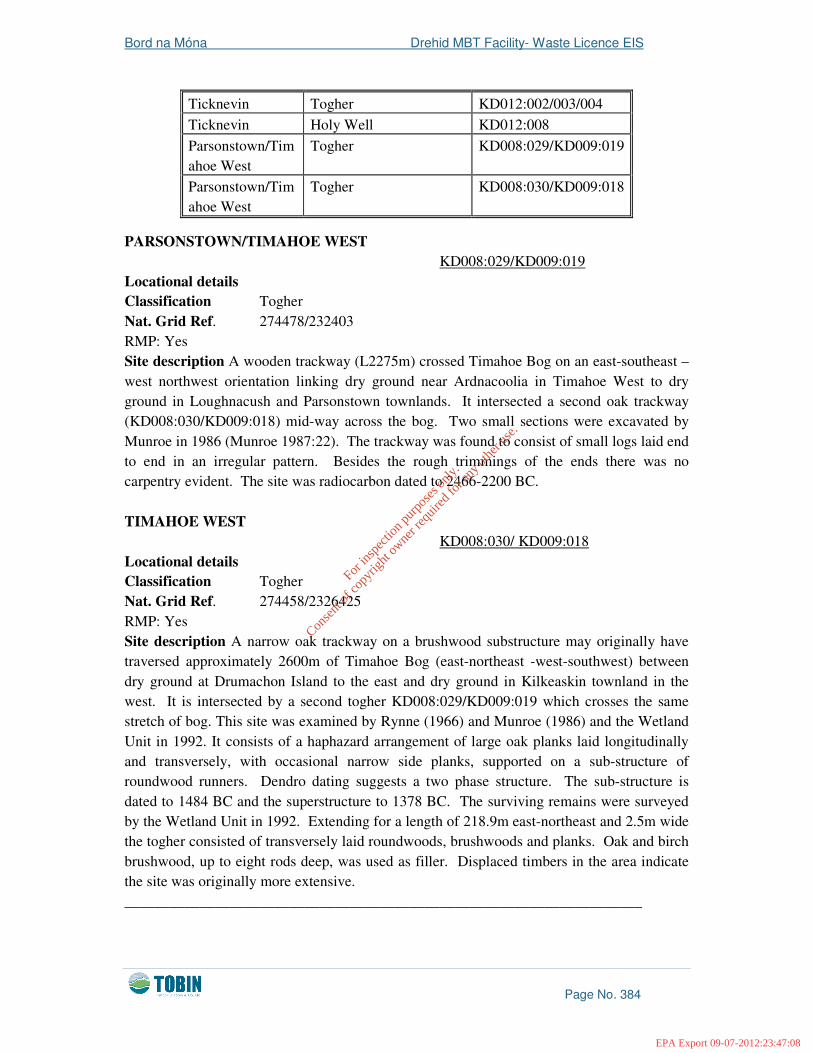
PARSONSTOWN/TIMAHOE WEST
KD008:029/KD009:019 Locational details
Classification Togher Nat. Grid Ref. 274478/232403 RMP: Yes Site description A wooden trackway (L2275m) crossed Timahoe Bog on an east-southeast – west northwest orientation linking dry ground near Ardnacoolia in Timahoe West to dry ground in Loughnacush and Parsonstown townlands. It intersected a second oak trackway (KD008:030/KD009:018) mid-way across the bog. Two small sections were excavated by Munroe in 1986 (Munroe 1987:22). The trackway was found to consist of small logs laid end to end in an irregular pattern. Besides the rough trimmings of the ends there was no carpentry evident. The site was radiocarbon dated to 2466-2200 BC. TIMAHOE WEST
KD008:030/ KD009:018 Locational details
Classification Togher Nat. Grid Ref. 274458/2326425 RMP: Yes Site description A narrow oak trackway on a brushwood substructure may originally have traversed approximately 2600m of Timahoe Bog (east-northeast -west-southwest) between dry ground at Drumachon Island to the east and dry ground in Kilkeaskin townland in the west. It is intersected by a second togher KD008:029/KD009:019 which crosses the same stretch of bog. This site was examined by Rynne (1966) and Munroe (1986) and the Wetland Unit in 1992. It consists of a haphazard arrangement of large oak planks laid longitudinally and transversely, with occasional narrow side planks, supported on a sub-structure of roundwood runners. Dendro dating suggests a two phase structure. The sub-structure is dated to 1484 BC and the superstructure to 1378 BC. The surviving remains were surveyed by the Wetland Unit in 1992. Extending for a length of 218.9m east-northeast and 2.5m wide the togher consisted of transversely laid roundwoods, brushwoods and planks. Oak and birch brushwood, up to eight rods deep, was used as filler. Displaced timbers in the area indicate the site was originally more extensive. _____________________________________________________________________
Ticknevin Togher KD012:002/003/004
Ticknevin Holy Well KD012:008
Parsonstown/Timahoe West
Togher KD008:029/KD009:019
Parsonstown/Timahoe West
Togher KD008:030/KD009:018
For
insp
ectio
n pur
pose
s only
.
Conse
nt of
copy
right
owne
r req
uired
for a
ny ot
her u
se.
EPA Export 09-07-2012:23:47:08

Bord na Móna Drehid MBT Facility- Waste Licence EIS
Page No. 385
COLLINSTOWN
KD008:007 Location Details
Classification: Enclosure site National Grid Ref.: 27112/23612 RMP: Yes Site Description: This site is marked on both the first and third edition of the Ordnance Survey Maps. It consists of a roughly circular earthwork set in a depression on a slight rise in good pasture land. The surrounding land is higher than the interior of the site. The ground drops to a fosse with an inner bank. The interior is very uneven and is planted with trees. The site measures 42m east-west and 26m north-south. No traces of this site exist today. _____________________________________________________________________ ARDKILL
KD008:008 Location Details
Classification: Castle (Tower House) National Grid Ref.: 27107/23530 RMP: Yes Site Description: This site is marked on both the first and third edition of the Ordnance Survey Maps. According to O’Donovan’s OS Letters (1838-1840) ‘…in the south east part of
the townland of Ardkill are the ruins of an old church and of a castle’. The tower house is dated to the fifteenth/sixteenth century, with the fireplace and chimney turret added in the seventeenth century. It is located on a natural rise in undulating pasture (well drained) surrounded by an area of low earthworks (especially to south-east) towards Ardkill. Only the south wall with a turret on the south-west corner and a small fragment of the north-east wall remain. The turret was added in order to add chimneys and has red brick in the fabric and is dated to the seventeenth/eighteenth century. In the east wall, at the top of the barrel vault over the ground floor, a joint line occurs where the wall under the vault is filled in. In the south wall a band of rough stones mark the level of the barrel vault between the ground and first floor. There are two breaks in the south wall, the break on the east is large and possibly marks the position of a doorway while that on the west is where the east wall and turret abut the south wall. The turret abuts the south-east corner and contains two flues, one from the ground floor runs behind that from first floor. On the ground floor the lower part of the flue is ruined, while on the first floor it is intact and widens out where the fireplace was. To the south-east of the castle there are numerous low earthworks over an extensive area between the castle and the church. There are no traces of the west tower, though there are joint lines evident where the curtain wall joined the tower. To the south-east of the bawn there are a series of large terraces and possible trackways. _____________________________________________________________________ ARDKILL KD008:009 Location Details
Classification: Church & Graveyard National Grid Ref.: 27121/23496
For
insp
ectio
n pur
pose
s only
.
Conse
nt of
copy
right
owne
r req
uired
for a
ny ot
her u
se.
EPA Export 09-07-2012:23:47:08

Bord na Móna Drehid MBT Facility- Waste Licence EIS
Page No. 386
RMP: Yes Site Description: This site is marked on both the first and third edition of the Ordnance Survey Maps. The church is enclosed by a low stone wall, polygonal in shape. The graveyard is overgrown, but is still used for burial. The entrance gate is located in the south-west corner. The church is rectangular in plan, orientated east/west with internal dimensions of 16m east/west and 6m north-south. The church is ruinous and completely overgrown. There are no datable architectural features present. The upstanding west wall is constructed of roughly coursed limestone. Though ivy covered, there are traces of a crude round-headed window visible, but no dressed stone evident. The remains of the north and south walls are mostly grass-covered. Only the south-east portion of the south wall survives to a height of 1.2m. The east wall is ruinous with ivy and grass covering it. There is evidence of a supporting buttress on the south-east corner with possible rubble remains of another, on the opposing north-east corner. Where the walls survive they have a maximum thickness of 0.9m. There are some late headstones in the interior, however no dates are discernible. ____________________________________________________________________ PARSONSTOWN
KD008:016 Location Details
Classification: Ringfort site National Grid Ref.: 27228/23322 RMP: Yes Site Description: This site is marked on the first and third edition of the Ordnance Survey Maps. It has been levelled and survives as a sub-circular mound with traces of a ditch encircling it, visible at the south and west. The site is clearly visible on the aerial photographs. The earthwork to the north of the site is the remains of a nineteenth-century house and farm, now abandoned. _____________________________________________________________________ RATHMORE
KD008:019 Location Details
Classification: Enclosure site National Grid Ref.: 27063/23112 RMP: Yes Site description: The site is marked on both the first and third edition of the Ordnance Survey Maps. It has been destroyed and the field is now under tillage. _____________________________________________________________________ COLLINSTOWN
KD008:020 Location Details
Classification: Church site National Grid Ref.: 27232/23490 RMP: Yes Site Description: This site is marked on both the first and third edition of the Ordnance
For
insp
ectio
n pur
pose
s only
.
Conse
nt of
copy
right
owne
r req
uired
for a
ny ot
her u
se.
EPA Export 09-07-2012:23:47:08

Bord na Móna Drehid MBT Facility- Waste Licence EIS
Page No. 387
Survey Maps. According to O’Donovan’s OS Letters (1838-1840) ‘Killcooney Church is
shown in the Maps from Sir William Petty’s Survey and some old people call the portion of
Collinstown south of Killcooney River, Killcooney townland’. There is no trace of any structure visible. At the east angle of the field there is a shallow fosse 0.4m deep, running in a straight line north-west/south-east. The farmer put many drains down in this area and quarrying was also carried out in the east of the field. _____________________________________________________________________ PARSONSTOWN
KD008:023 Location Details
Classification: Ringfort possible National Grid Ref.: 27217/23315 RMP: Yes Site Description: This site is marked on both the first and third edition of the Ordnance Survey Maps. It consists of an oval enclosure, largely denuded, located 30m south of Parsonstown multivallate rath. It has an entrance causeway at the north-east and there are earthworks between it and the rath. _____________________________________________________________________ DREHID
KD008:024 Location Details
Classification: Enclosure National Grid Ref.: 27318/23449 RMP: Yes Site Description: This site is marked on both the first and third edition of the Ordnance Survey Maps. There is no visible trace of this site. The present field remnants point towards a rectangular earthwork but this may be due to later disturbance. The present landholders note that the previous owners called it the ‘rath’-treating it with suspicion as one of their kins hair turned white over some incident. During the Emergency the trees at centre were felled for timber. It was mentioned that they were in a circle. This area has been hollowed out for yellow clay for house buildings, leaving a water-filled pond. Later reclaimed, the pond was drained and the area levelled by a bulldozer. It is now left as a haggard. _____________________________________________________________________ DREHID
KD008:025/009:017 Location Details
Classification: Togher National Grid Ref.: 27492/23412 RMP: Yes Site Description: This site consists of a scatter of broken and displaced timbers noted along the north-facing bank in an area of peat cutting. To the west, in an area of uncut peat, timbers were noted in the face of old cutting. It is probably the same togher, apparently running
For
insp
ectio
n pur
pose
s only
.
Conse
nt of
copy
right
owne
r req
uired
for a
ny ot
her u
se.
EPA Export 09-07-2012:23:47:08

Bord na Móna Drehid MBT Facility- Waste Licence EIS
Page No. 388
north-west/south-east across a narrow part of Timahoe Bog. _____________________________________________________________________ DREHID
KD008:026 Location Details
Classification: Togher National Grid Ref.: 27478/23369 RMP: Yes Site Description: In 1995 a timber structure was uncovered here during the course of bog drainage operations. In a drainage cutting, which was about 1m wide and on average 2m in depth, a timber structure some 5m wide, 0.17m in thickness and 1.6m below the present (shrunken) surface of the bog was apparent. This togher or timber causeway was comprised (in this first cutting excavated) of light branches laid on each other, some crosswise, and others slanting, but not interwoven in any regular fashion. Below these branches was some 0.06m of what is locally described as ‘ciabh’ or sedge on which the timbers had been placed. There were more peat foundations below this sedge layer. In other cuttings inspected some large hewn timbers were observed. One of these measured over 1.05m in length and 0.22m in width and 0.08m in thickness. There were no traces of any work on the large beams, such as mortice and tenons. A portion of the togher in the first cutting was excavated and the only finds were a number of broken hazel nut shells. _____________________________________________________________________ DREHID
KD008:027 Location Details
Classification: Togher National Grid Ref.: 27458/23345 RMP: Yes Site Description: Timbers of a trackway were identified at this location on several occasions lying close to the present surface and have been dated to the medieval period. _____________________________________________________________________ TIMAHOE WEST
KD008:036 Location Details
Classification: Togher /Unclassified Road National Grid Ref.: 275061/232772 RMP: Yes Site Description: The site (L115m, W 2.1m, D 0.2m) is orientated NW-SE and consists of a compact layer of longitudinal ash and oak roundwoods (Diam. 0.08-0.16m) with occasional hazel brushwood rods. Some of the roundwoods have been split in half. Pegs, worked into wedge and chisel points, secure the outer edge of the structure. In some areas the upper surface of the timbers are charred and some hazelnuts are present. _____________________________________________________________________
For
insp
ectio
n pur
pose
s only
.
Conse
nt of
copy
right
owne
r req
uired
for a
ny ot
her u
se.
EPA Export 09-07-2012:23:47:08

Bord na Móna Drehid MBT Facility- Waste Licence EIS
Page No. 389
TIMAHOE WEST
KD008:037 Location Details
Classification: Togher /Unclassified Road National Grid Ref.: 275048/232504 RMP: Yes Site Description: A two layered structure (L61.8m, W 3.1m, D 0.33m) lying just 0.3m above the mineral soil. It is composed of a compact longitudinal roundwood and brushwood superstructure over a thin, dispersed layer of brushwood (hazel, birch and yew) four rods deep. A number of pieces are worked into wedges and chisel points. _____________________________________________________________________ TIMAHOE WEST
KD008:038 Location Details
Classification: Togher National Grid Ref.: 274775/231721 RMP: No Site Description: The site (L72m, W 1m) consists of several pieces of hazel brushwood (diam. 0.01-0.25m) in a haphazard arrangement, probably the destroyed remains of a more substantial structure. _____________________________________________________________________ TIMAHOE WEST
KD008:043 Location Details
Classification: Peatland Structure National Grid Ref.: 274999/232778 RMP: Yes Site Description: The site is exposed in section in the north face of a turf bank 2.5m high. It comprises a partially removed and degrading deposit of over 15 pieces of light brushwood and twigs. _____________________________________________________________________ MULGEETH
SMR KD009:001 Location Details
Classification: Enclosure site National Grid Ref.: 27776/23566 RMP: Yes Site Description: This site is marked on both the first and third edition of the Ordnance Survey Maps. There is no other information available for this site. _____________________________________________________________________ TIMAHOE WEST
SMR KD009:006 Location Details
For
insp
ectio
n pur
pose
s only
.
Conse
nt of
copy
right
owne
r req
uired
for a
ny ot
her u
se.
EPA Export 09-07-2012:23:47:08

Bord na Móna Drehid MBT Facility- Waste Licence EIS
Page No. 390
Classification: Trackway (s) National Grid Ref.: 27592/23253 RMP: Yes Site Description: This site is marked on both the first and third edition of the Ordnance Survey Maps. A trackway, 3m wide and with a fosse on either side is visible running for a short distance in a southern direction from the children’s burial ground (KD009:00601). It is cut by a crop mark of a former field boundary, probably connected although not shown on the OS first edition. A second track to the west of site is also visible. _____________________________________________________________________ TIMAHOE WEST
SMR KD009:00601 Location Details
Classification: Children’s burial ground National Grid Ref.: 27592/23253 RMP: Yes Site Description: This site is marked on both the first and third edition of the Ordnance Survey Maps. It is located on a small low rise on the edge of a bog. It is enclosed and overgrown (D. c. 30m). The uneven appearance of the surface is probably due to the collapse of old trees and grass-covered stumps. No headstones or indeed stones of any sort are visible. _____________________________________________________________________ COLLOGMARTIN
SMR KD009:007 Location Details
Classification: Enclosure site National Grid Ref.: 27819/23270 RMP: Yes Site Description: This site is marked on both the first and third edition of the Ordnance Survey Maps and is located on Coologmartin Hill. The owner states that there was formerly a ‘depression’ on the hill-top, just to the north of the summit. The depression was filled in and the area levelled and re-seeded recently. The hill-top is now in meadow. There is no indication of an earthwork apart from a slight depression to the north of the summit. _____________________________________________________________________
TIMAHOE EAST
SMR KD009:008 Location Details
Classification: Church & Graveyard National Grid Ref.: 27744/23210 RMP: Yes Site Description: This site is marked on both the first and third edition of the Ordnance Survey Maps. According to O’Donovan’s Ordnance Survey Letters (1838-40) ‘at Timahoe
village, which is between the townlands of East and West Timahoe, there is an old church in
ruins’. According to the field inspection carried out by the National Monuments Service the
For
insp
ectio
n pur
pose
s only
.
Conse
nt of
copy
right
owne
r req
uired
for a
ny ot
her u
se.
EPA Export 09-07-2012:23:47:08

Bord na Móna Drehid MBT Facility- Waste Licence EIS
Page No. 391
overgrown foundations of a rectangular structure are visible (c. 20m by 5m). Small portions of the wall adjacent to the south-west corner still stand but are in very poor condition, consisting chiefly of the rubble core of the wall, with a lintelled gap where a former window was. The graveyard is oval-shaped (40m by 31m) and is slightly smaller than the area enclosed by the modern wall. It is higher than the surrounding field level and contains a large number of headstones, many of eighteenth-century date. _____________________________________________________________________
TIMAHOE WEST
SMR KD009:009 Location Details
Classification: Castle site National Grid Ref.: 27739/23195 RMP: Yes Site Description: This site is marked on both the first and third edition of the Ordnance Survey Maps. According to O’Donovan’s Letters (1838-1840) ‘in the east portion of west
Timahoe townland there is a field called Castlefield, close to the village. In this field there
stood formerly a castle, the walls of which were entirely cleared away more than thirty years
ago’. According to the National Monuments Service this site lies in open, in very slightly undulating pastureland. There are some lazy beds in the vicinity but not visible over the site. _____________________________________________________________________ GILLTOWN
SMR KD009:010 Location Details
Classification: Enclosure site National Grid Ref.: 28010/23225 RMP: Yes Site Description: This site is marked on both the first and third edition of the Ordnance Survey Maps. The site is also indicated on Taylor’s Map of 1783. There is no other information available for this site. _____________________________________________________________________ TIMAHOE WEST
KD009:027 Location Details
Classification: Peatland Structure National Grid Ref.: 275404/232014 RMP: No Site Description: A single dried out piece of broken yew roundwood with one edge worked into a wedge point. It was revealed by turf cutting operations and may be associated with KD009:028. ____________________________________________________________________
For
insp
ectio
n pur
pose
s only
.
Conse
nt of
copy
right
owne
r req
uired
for a
ny ot
her u
se.
EPA Export 09-07-2012:23:47:08

Bord na Móna Drehid MBT Facility- Waste Licence EIS
Page No. 392
TIMAHOE WEST
KD009:028 Location Details
Classification: Peatland Structure National Grid Ref.: 275338/232441 RMP: No Site Description: The site consists of transversed and longitudinal roundwoods and brushwood of birch. Many pieces had their ends worked into wedges and chisel points. _____________________________________________________________________
COOLCARRIGAN
KD009:029 Location Details
Classification: Unclassified Road National Grid Ref.: 275199/231889 RMP: No Site Description: The site consists of a number of roundwoods lying upon occasional longitudinals with scatters of brushwood nearby. Several timbers were burned. ________________________________________________________________ TIMAHOE WEST
KD009:030 Location Details
Classification: Peatland Structure National Grid Ref.: 275120/232466 RMP: No Site Description: A single worked yew roundwood the end of which had been worked into a wedge point and may have formed part of a peatland structure KD009:028. _____________________________________________________________________ TIMAHOE WEST
KD009:034 Location Details
Classification: Peatland Structure National Grid Ref.: 275087/232491 RMP: No Site Description: A small area formed by several worked roundwoods predominantly of yew. The end of one roundwood is worked into a chisel point. _____________________________________________________________________
TIMAHOE WEST
KD009:035 Location Details
Classification: Peatland Structure National Grid Ref.: 275099/232473
For
insp
ectio
n pur
pose
s only
.
Conse
nt of
copy
right
owne
r req
uired
for a
ny ot
her u
se.
EPA Export 09-07-2012:23:47:08

Bord na Móna Drehid MBT Facility- Waste Licence EIS
Page No. 393
RMP: No Site Description: A single dried out broken yew roundwood with its end worked into a wedge. _____________________________________________________________________ KILPATRICK
SMR KD012:001 Location Details
Classification: Graveyard National Grid Ref.: 27122/22966 RMP: Yes Site Description: This site is marked on both the first and third edition of the Ordnance Survey Maps. According to O’Donovan’s OS Letters (1838-1840) ‘there is a graveyard in
the north east part of Kilpatrick townland in which I am told there is no part of a church
remaining’. It is shown on 1909 OS 6" map as a sub rectangular area. _____________________________________________________________________ TICKNEVIN/ DERRYBRENNAN/ BALLINDOOLIN/ BALLYBRACK/
LULLYMORE WEST
SMR KD012:002/003/004 Location Details
Classification: Togher RMP: Yes
Site Description: This site is marked on both the first and third edition of the Ordnance Survey Maps. The togher ran in an approximately north-north-west/south-south-east direction across the north-east part of the bog. The total length of the togher investigated ran in a straight line aligned between the peaks of Carbury Hill, to the north and Grange Hill to the south. During turf cutting operations in Lullymore Bog three stretches of bog road were uncovered in 1964, but were not continuous. _____________________________________________________________________ TICKNEVIN
SMR KD012:008 Location Details
Classification: Holy well National Grid Ref.: 26956/22998 RMP: Yes Site Description: This site is marked on both the first and third edition of the Ordnance Survey Maps. It is situated in the old graveyard at Ticknevin. There is no record of a pattern at this well. There is a cure for warts in the well and in order to be cured three visits have to be made to the well. On the first visit the suppliant leaves three pins at the side of the well. On the third visit the pins are gone and the warts are cured. There is a stone beside the well which reputedly retains the imprint of the Saint’s foot. _____________________________________________________________________
For
insp
ectio
n pur
pose
s only
.
Conse
nt of
copy
right
owne
r req
uired
for a
ny ot
her u
se.
EPA Export 09-07-2012:23:47:08

Bord na Móna Drehid MBT Facility- Waste Licence EIS
Page No. 394
COOLEARAGH WEST
SMR KD013:002 Location Details
Classification: Ringfort National Grid Ref.: 27835/22781 RMP: Yes Site Description: This site is marked on both the first and third edition of the Ordnance Survey Maps. It consists of a circular enclosure outlined by a fosse and a bank or embankment. The fosse is much silted up and is barely traceable in some places, the bank is of earth and is low and is set on an embankment. The interior is flat and has traces of cultivation ridges. The site is on a rise in open pasture land. There are bushes and brambles growing on the bank and the interior on the eastern side of the earthwork. The diameter of the interior is 22m. There is a possible entrance at north-west. The field boundaries adjoin at the north and north-west sides. 12.2.5 Cultural Heritage Sites in the area
It is the policy of Kildare County Council as published in the County Development Plan 2011-2017 to promote an appreciation of the landscape and historical importance of traditional and historic gardens, demesnes and parks within Kildare in general and particularly where they constitute an important setting to a protected structure. Two buildings of architectural/ cultural heritage significance are located in the vicinity of the proposed development. Coolcarrigan House and Church (Reg. B09-10, B09-11) are located approximately 1.6km east of the proposed development and will not be directly impacted. The house was constructed in the 1830’s and was originally used as a shooting lodge. It has extensive gardens and a 19th century Hiberno-Romanesque church on the grounds. A mixed coniferous and deciduous tree belt along the eastern edge of the existing bog ensures that these structures will not be visually impacted by the proposed facility. 12.2.6 Archaeological artefacts recorded from the area
The following archaeological artefacts are included to highlight the type of archaeological activity in the area and the importance of archaeological monitoring as stray finds are frequently found in the course of monitoring of ground works. Archaeological finds recorded in the topographical files of the National Museum of Ireland indicate human activity in the general area from the Neolithic period with many of the artefacts recovered from a peat environment. While the bogs have since been harvested it is possible that further artefacts and/or features survive in the lower levels of peat. A study of the topographical files housed in the National Museum of Ireland yielded the following archaeological artefacts: Townland Allenwood South Registration No. 1987:72 Find Type leather shoe
For
insp
ectio
n pur
pose
s only
.
Conse
nt of
copy
right
owne
r req
uired
for a
ny ot
her u
se.
EPA Export 09-07-2012:23:47:08

Bord na Móna Drehid MBT Facility- Waste Licence EIS
Page No. 395
Found in bog 1.25m deep _____________________________________________________________________ Townland Allenwood South Registration No. 1987:71 Find Type Bronze Cauldron (15th /16th century) Found in bog 1.25m deep _____________________________________________________________________ Townland Allenwood Middle Registration No. 1942:1870 Find Type Bronze Rapier Found in bog _____________________________________________________________________ Townland Ardkill Registration No. 1937:2433 Find Type Stone Axehead Found
_____________________________________________________________________ Townland Ballybrack Registration No. 1937:2438-44 Find Type Stone Implement Found
_____________________________________________________________________ Townland Ballybrack Registration No. 1937:2421 Find Type Stone Axehead Found
____________________________________________________________________ Townland Ballynakill Lower/Upper Registration No. 1962:75 Find Type Iron Axehead “bearded” type Found in boggy land _____________________________________________________________________ Townland Ballyteague Registration No. - Find Type Designed Stone Found near Castle _____________________________________________________________________ Townland Coolcarrig Registration No. 1979:7 Find Type wooden shovel blade Found 5.5m below bog surface _____________________________________________________________________ Townland Coolcarrig
For
insp
ectio
n pur
pose
s only
.
Conse
nt of
copy
right
owne
r req
uired
for a
ny ot
her u
se.
EPA Export 09-07-2012:23:47:08

Bord na Móna Drehid MBT Facility- Waste Licence EIS
Page No. 396
Registration No. 1979:9 Find Type wooden keg with bog butter Found in bog _____________________________________________________________________ Townland Demense Registration No. 1950:31 Find Type Stone object (point) Found open field during ploughing _____________________________________________________________________ Townland Downings Registration No. 1945:268 Find Type Stone Axehead Found
_____________________________________________________________________ Townland Drehid Registration No. 1972:355 A&B Find Type Bent wooden stake (in two parts) Found 4ft deep in bog cutting _____________________________________________________________________ Townland Kilkeaskin Registration No. 1937:2420 Find Type Stone axehead Found
_____________________________________________________________________ Townland Kilkeaskin (‘The River Field’) Registration No. 1968:438-439 Find Type 2 polished stone axeheads Found
_____________________________________________________________________ Townland Killinagh Registration No. 1994:72 Find Type wood in bog Found
_____________________________________________________________________ Townland Killinagh Registration No. 1929:1298 Find Type bog butter Found at depth of 6ft in bog _____________________________________________________________________ Townland Mulgeeth Registration No. 1980:46 Find Type wooden object Found in bog of unknown depth
For
insp
ectio
n pur
pose
s only
.
Conse
nt of
copy
right
owne
r req
uired
for a
ny ot
her u
se.
EPA Export 09-07-2012:23:47:08

Bord na Móna Drehid MBT Facility- Waste Licence EIS
Page No. 397
_____________________________________________________________________ Townland Mylerstown Registration No. 1991:44 Find Type Stone axehead Found Field close to bog _____________________________________________________________________ Townland Ticknevin Registration No. 1987:140 Find Type Leather Shoe Found Bog _____________________________________________________________________ Townland Timahoe East Registration No. 1943:132 Find Type Portion of solid wooden wheel Found Bog _____________________________________________________________________ Townland Timahoe East Registration No. 1938:8560 Find Type Fragment of large stone axehead Found
_____________________________________________________________________ Townland Timahoe East Registration No. 1943:286 Find Type Silver bracelet Found Bog _____________________________________________________________________ Townland Timahoe East Registration No. 1943:130-131 Find Type Wooden yoke and long perforated timber Found Bog _____________________________________________________________________ Townland Timahoe East Registration No. 1950:7 Find Type Iron axe Found at depth of 6ft during cutting operations _____________________________________________________________________ Townland Timahoe Bog Registration No.
Find Type Bog body –human forearm Found in 1959 during hand-work operations _____________________________________________________________________ Townland Timahoe Registration No. 1950:4a, 4b, 4c
For
insp
ectio
n pur
pose
s only
.
Conse
nt of
copy
right
owne
r req
uired
for a
ny ot
her u
se.
EPA Export 09-07-2012:23:47:08

Bord na Móna Drehid MBT Facility- Waste Licence EIS
Page No. 398
Find Type 3 portions of wooden vessel Found in bog at depth of 7ft. _____________________________________________________________________ Townland Timahoe (Derrymahon Bog) Registration No. 1942:409 Find Type Wooden object Found 3 ft. below bog _____________________________________________________________________ Townland Timahoe East or West Registration No. 1978:3 Find Type Leather shoe Found
_____________________________________________________________________ Townland Timahoe Registration No. 1941:1120 Find Type Bronze spearhead Found
_____________________________________________________________________ Townland Timahoe Bog, Timahoe West Registration No. 1966:2 Find Type Flint arrowhead (barbed) Found
_____________________________________________________________________ Townland Timahoe West Registration No. 1970:139 Find Type Rough out for two handled wooden vessels Found
_____________________________________________________________________ Townland Timahoe Bog Registration No. - Find Type Human skeletal remains Found in area of Drummond or Ballynakill Lower Townland _____________________________________________________________________ Townland Roberstown Registration No. 1994:62 Find Type bronze socketed axehead Found in bog _____________________________________________________________________
For
insp
ectio
n pur
pose
s only
.
Conse
nt of
copy
right
owne
r req
uired
for a
ny ot
her u
se.
EPA Export 09-07-2012:23:47:08

Bord na Móna Drehid MBT Facility- Waste Licence EIS
Page No. 399
12.2.7 References
• Author unknown. The Annals of the Four Masters. Accessed at: www.ucc.ie/celt/published/T100054/text077.html. February 2007.
• Alcock, O. 1999. Archaeological inventory of County Galway, Part 2 North Galway. Dublin.
• Bolton. J. 2008. Directory of Archaeological Sources Relating to County Kildare. Dublin.
• Cairns, C.T. 1987. Irish tower houses: a county Tipperary case study. Athlone. • Coill Dubh Book Committee 1993. Coill Dubh 1952-1992. • Connolly, S.J. (ed.) 2004. The Oxford Companion to Irish History, 2nd Edition.
Oxford. Oxford University Press. • Cooney, G. and Grogan, E. 1995. Irish prehistory: a social perspective. Dublin. • Cullen, S. 1998. Conflict and Rebellion in North Kildare. In S. Cullen & H. Geissel
(eds.) Fugitive Warfare: 1798 in North Kildare, pp.1-33. • Lord Edward Fitzgerald 1798 Committee, Kilcock-Newtown in conjunction with
CRS Publications. • Harbison, P. 1988. Pre-Christian Ireland: from the first settlers to the early Celts.
London. • Killanin, Lord and Duignan, M.V. 1962. Shell Guide to Ireland. London. • Kildare County Development Plan 2011-2017. • Lewis, S. 1837. A topographical dictionary of Ireland, 2 vols. London. • O’Brien, C. and Sweetman, P.D. 1997. Archaeological inventory of County Offaly.
Dublin. • O’Donovan, J. 2002. In M. Herity (ed.) Ordnance Survey Letters Kildare. Dublin.
Fourmasters Press. • O’Farrell, P. 1998. The ’98 Reader. Dublin. • Waddell, J. 1998. The prehistoric archaeology of Ireland. Galway. • Turrell, S.J. & Flood, R. 2007. Archaeological Monitoring of Peat Stripping at Drehid
Bog, Co. Kildare. ADS Ltd. Unpublished Report. • Turrell, S.J. 2008. Archaeological Monitoring of Peat Stripping at Drehid Bog, Co.
Kildare. ADS Ltd. Unpublished Report. • Turrell, S.J. 2010. Archaeological Monitoring of Peat Stripping at Drehid Bog, Co.
Kildare. ADS Ltd. Unpublished Report. 12.2.8. Cartographic Evidence & Aerial Photography
An examination of old maps and aerial photographs of the subject site revealed nothing of archaeological significance. The 1752 map by Noble and Keenan records the Bog of Allen with Timahoe and Drehid marked. The area of the proposed development is indicated as part of the vast bog in this mid 18th century map. Alexander Taylor’s map of 1783 similarly depicts the area as a vast bog with the Cashanure River to the west. The first edition ordnance survey map produced in the mid 19th century highlights Coolcarrigan Demesne to
For
insp
ectio
n pur
pose
s only
.
Conse
nt of
copy
right
owne
r req
uired
for a
ny ot
her u
se.
EPA Export 09-07-2012:23:47:08

Bord na Móna Drehid MBT Facility- Waste Licence EIS
Page No. 400
the east of the site but no feature is indicated in the area proposed for development. More recent maps and aerial photographs highlight the drainage channels throughout the site. Nothing of archaeological significance is marked in the area of the proposed development on any of the maps or aerial photographs. 12.2.9. Archaeological Assessment
The site of the proposed development is in an area located immediately east of the existing access road to the Drehid Waste Management Facility (Plate 1). The archaeological assessment was conducted in order to determine if any previously unrecorded sites exist in the area proposed for development. The assessment involved an analysis of previous work on the site and a walkover survey of the proposed development concentrating on the areas of cutover bog and drain faces - where it might be possible to identify archaeological features more readily. The evidence from archaeological monitoring of all ground disturbance associated with the Drehid Waste Management Facility to the north was also examined. In 2006 archaeological monitoring of the initial phases of the Drehid Waste Management Facility groundworks was carried out by Archaeological Development Services Ltd (Turrell & Flood 2007). This included the monitoring of the access road located to the east of the proposed MBT facility. In 2008/9 further monitoring was carried out in advance of the construction of additional landfill cells (Phases 3, 4 & 5) (Turrell 2009). Further monitoring associated with a biowaste composting facility was undertaken in 2010-2011. Nothing of archaeological interest was noted during the course of these groundworks.
Plate 1: General view of the proposed development site from the west.
Timahoe Bog is part of Bord na Móna’s Allen group of bogs which were first brought into industrial peat production in the 1950’s. Peak production at Timahoe Bog was achieved during the 1960's when the bog was in sod peat production. The peat was removed from the bog via a railway system, with many of the tracks, or sections of them still in place. One such section of track runs from east to west through the proposed development site (Plate 3). The track is overgrown with grass but the iron rail is still visible in places. Industrial production at the site was gradually phased out over the last twenty two years as most of the bog was cut away and the poor quality of the remaining peat made further peat harvesting
For
insp
ectio
n pur
pose
s only
.
Conse
nt of
copy
right
owne
r req
uired
for a
ny ot
her u
se.
EPA Export 09-07-2012:23:47:08

Bord na Móna Drehid MBT Facility- Waste Licence EIS
Page No. 401
uneconomical. Small scale production for domestic purposes continues at the margins of the commercially cut away bog. To reduce the moisture content of the peat material during the years of peak industrial activity it was necessary to drain the entire bog. This was achieved by the excavation of a network of east to west running drains that discharged into a central underground culvert that ran from north to south. The drainage network facilitated heavy plant and machinery to safely traverse the bog. As a result of the drainage channels the entire site is divided into plots referred to as ‘peat fields’. These turf plots span the length of the bog. In some areas they have been exploited to a depth of 0.5m-1m above the natural mineral soil. The surface areas of the proposed development site consist of tracts of flat low-lying bog with varying densities of vegetation cover. The walk over survey was restricted to areas where over-growth was sparse or non-existent. Investigation of drain section faces and a walkover of the area yielded nothing of archaeological interest.
Plates 2 & 3: View from east and detail of railway track running from east to west
12.3 POTENTIAL IMPACTS
12.2.1 Potential Impacts of Configuration A (MBT with Composting)
Given the partly overgrown nature of the site of the proposed development a full survey of the area proved problematic. However the walk-over survey of the proposed development site revealed no features of archaeological or cultural heritage significance. Furthermore the archaeological assessment of the area indicates that the proposed development will not impact on any known features or artefacts.
For
insp
ectio
n pur
pose
s only
.
Conse
nt of
copy
right
owne
r req
uired
for a
ny ot
her u
se.
EPA Export 09-07-2012:23:47:08

Bord na Móna Drehid MBT Facility- Waste Licence EIS
Page No. 402
12.2.2 Potential Impacts of Configuration B (MBT with Dry Anaerobic Digestion and
Composting)
The walk-over survey of the proposed development site revealed no features of archaeological significance. Furthermore the archaeological assessment of the area indicates that the proposed development will not impact on any known features or artefacts.
12.4. MITIGATION MEASURES
12.2.3 Mitigation measures for Configuration A (MBT with Composting)
Archaeological finds recorded in the topographical files of the National Museum of Ireland indicate human activity in the general area from the Neolithic period with many of the artefacts recovered from a peat environment. While the bogs have since been harvested it is possible that further artefacts and/or features survive in the lower levels of peat. It is therefore proposed that prior to development the vegetation is cleared, as this will assist in determining if any features of archaeological significance are present in these areas. The removal of vegetation will be undertaken in advance of construction works and will be monitored by a suitably qualified archaeologist. The route of the existing railway will be recorded to ensure its documentation as part of the industrial heritage of the site. All ground disturbance associated with the development will be monitored by a suitably qualified archaeologist working under the appropriate license. 12.2.4 Mitigation measures for Configuration B (MBT with Dry Anaerobic Digestion and
Composting)
Similarly to above, it is proposed that prior to development the vegetation is cleared, as this will assist in determining if any features of archaeological significance are present. The removal of vegetation will be undertaken in advance of construction works and will be monitored by a suitably qualified archaeologist. The route of the existing railway will be recorded. All ground disturbance associated with the development will be monitored by a suitably qualified archaeologist working under the appropriate license.
12.5 CONCLUSIONS
Timahoe and its environs have evidence of the presence of humans possibly dating from the Bronze Age as indicated by the dendrochronological dating of the toghers from Timahoe Bog. However, the recovery of eight axeheads and a flint arrowhead suggests earlier activity
For
insp
ectio
n pur
pose
s only
.
Conse
nt of
copy
right
owne
r req
uired
for a
ny ot
her u
se.
EPA Export 09-07-2012:23:47:08

Bord na Móna Drehid MBT Facility- Waste Licence EIS
Page No. 403
dating to the Neolithic period (4000-2000 BC). Artefacts recovered from the area, which are generally found in a bog environment includes leather shoes and portion of a wooden wheel. The area continued to be occupied throughout the medieval period as indicated by the presence of church and castle sites in the vicinity of the proposed development. Given the partly overgrown nature of the site of the proposed development a full survey of the area proved problematic. The archaeological and cartographic records indicate no features of archaeological significance in the area of the proposed development. The evidence from archaeological monitoring of all ground disturbance associated with the existing Drehid Waste Management Facility is equally devoid of archaeology (See Section 12.2.9). Previous works also included the archaeological monitoring of the access road to the Drehid Waste Management Facility. This roadway is located immediately west of the proposed development site. Nothing of archaeological significance was encountered during archaeological monitoring of this roadway. Archaeological finds recorded in the topographical files of the National Museum of Ireland indicate human activity in the general area from the Neolithic period with many of the artefacts recovered from a peat environment. While the bogs have since been harvested it is possible that further artefacts and/or features survive in the lower levels of peat. It is therefore recommended that in advance of construction all vegetation on the site will be cleared to enable a full appraisal and that during construction all ground disturbance be archaeologically monitored. The mitigation measures proposed here are subject to ratification by National Monuments, Department of Arts, Heritage and Gaeltacht Affairs.
For
insp
ectio
n pur
pose
s only
.
Conse
nt of
copy
right
owne
r req
uired
for a
ny ot
her u
se.
EPA Export 09-07-2012:23:47:08

Bord na Móna Drehid MBT Facility- Waste Licence EIS
Page No. 404
For
insp
ectio
n pur
pose
s only
.
Conse
nt of
copy
right
owne
r req
uired
for a
ny ot
her u
se.
EPA Export 09-07-2012:23:47:08

Bord na Móna Drehid MBT Facility- Waste Licence EIS
Page No. 405
13 INTERACTION OF THE FOREGOING
The significant impacts of the proposed development and the measures proposed to mitigate these impacts have been outlined in this EIS. However, in any development with the potential for environmental impact there is also the potential for interaction between impacts of the different environmental aspects. The result of these interactions may either exacerbate the magnitude of the impact or may in fact ameliorate it. As part of the requirements of an Environmental Impact Statement (EIS), the interaction of the impacts on the surrounding environment needs to be addressed. There is the potential for interaction between the impacts of the proposed MBT Facility development and also the potential for interaction with the previously permitted Drehid Waste Management Facility (as both are located within the same Bord na Móna landholding). Potential interactions between the impacts of various environmental aspects are as follows:
• Potential odour and air emissions will be controlled as all processing activities will take place within enclosed buildings. A building ventilation and odour abatement system will be employed at the MBT Facility. The maintenance of a negative pressure environment within each building will prevent the emission of untreated air thereby minimising potentially nuisance causing odour emissions. These measures will reduce the impact on human beings in the community.
• Dust suppression and vehicle wheel washes will be used at the MBT Facility to mitigate the impact of any wind blown dust around the site and to nearby dwellings. These measures will reduce the potential impact on human beings, material assets and ecological receptors.
• Travel patterns will not be disrupted by the proposed MBT Facility development, however vehicle numbers will increase. Mitigation measures, which have been employed at the site entrance, will reduce the impact of the development and additional mitigation measures for the MBT Facility have also been proposed within the EIS. These measures will improve road safety for all road users.
• Professional vermin control experts will be employed to ensure the potential for vermin activity is minimised. These measures will reduce impacts on human beings and material assets.
• Compliance monitoring of groundwater, surface water, noise, air and dust will be undertaken as per regulatory conditions and annual environmental reports will be compiled to detail the performance of the MBT Facility. These reports will be made available to all interested parties, which will allay public concerns as to the operation of the site and will result in a positive interaction with respect to human beings and flora and fauna.
• There is the potential for interaction between groundwater, surface water and ecology and this interaction has been considered in the relevant sections of the EIS.
For
insp
ectio
n pur
pose
s only
.
Conse
nt of
copy
right
owne
r req
uired
for a
ny ot
her u
se.
EPA Export 09-07-2012:23:47:08

Bord na Móna Drehid MBT Facility- Waste Licence EIS
Page No. 406
• The MBT Facility will be operated to Best Available Techniques (BAT) as per EPA recommendations. A complaints register will be maintained and the EPA will undertake regular environmental audits, which will demonstrate how the MBT Facility is performing. These measures will result in interaction in all environmental criteria.
• Finally, it should be noted that throughout the EIS potential interaction between various environmental criteria are discussed. The proposed MBT Facility will be sited at a significant distance from the local road network and residential properties, with the nearest residence being approximately 1km from the facility footprint. Avoidance of impacts was used throughout the design of the MBT Facility. The mitigation measures proposed are designed to further ameliorate the impact of the proposed MBT Facility on the wider environment and the potential cumulative impact of the development within the same Bord na Móna landholding as the permitted Drehid Waste Management Facility.
While there is potential for the above impacts to interact and result in a cumulative impact, it is unlikely that any of these cumulative impacts will result in significant environmental degradation. It should also be noted that the proposed MBT Facility will divert biodegradable municipal solid waste from the existing landfill at the adjacent Drehid Waste Management Facility. Biodegradable municipal solid waste will be diverted, by the MBT Facility, by the biostabilisation of the organic fraction and the production of SRF. The biostabilisation of biodegradable municipal waste significantly reduces its potential to generate landfill gas when landfilled. As a result, the MBT Facility is likely to have a positive effect on odour emissions from the existing landfill. In this regard, the proposed MBT Facility will have a positive effect on human beings in the community. Given that outputs from the proposed MBT Facility will be accepted at the existing landfill at the Drehid Waste Management Facility for the remainder of its operational life, there will be a corresponding reduction in the amount of waste accepted directly at the existing landfill from external sources.
For
insp
ectio
n pur
pose
s only
.
Conse
nt of
copy
right
owne
r req
uired
for a
ny ot
her u
se.
EPA Export 09-07-2012:23:47:08

Galway Fairgreen House, Fairgreen Road, Galway. Ph +353 (0)91 565211
Dublin Block 10-4, Blanchardstown Corporate Park, Dublin 15.
INTERNATIONAL NETWORK
Castlebar Market Square, Castlebar, Co. Mayo. Ph +353 (0)94 902 1401
Poland Ul. Cystersów 9
31-553 Kraków Ph +48 12 353 8646
United Kingdom
CAB International,
Nosworthy Way,
Wallingford,
Oxfordshire OX10 8DE
Ph +44 1491 829327
For
insp
ectio
n pur
pose
s only
.
Conse
nt of
copy
right
owne
r req
uired
for a
ny ot
her u
se.
EPA Export 09-07-2012:23:47:08