110 - marine and coasts · 2017-03-28 · 2.12 piles are assumed to be free issue at portsea,...
TRANSCRIPT
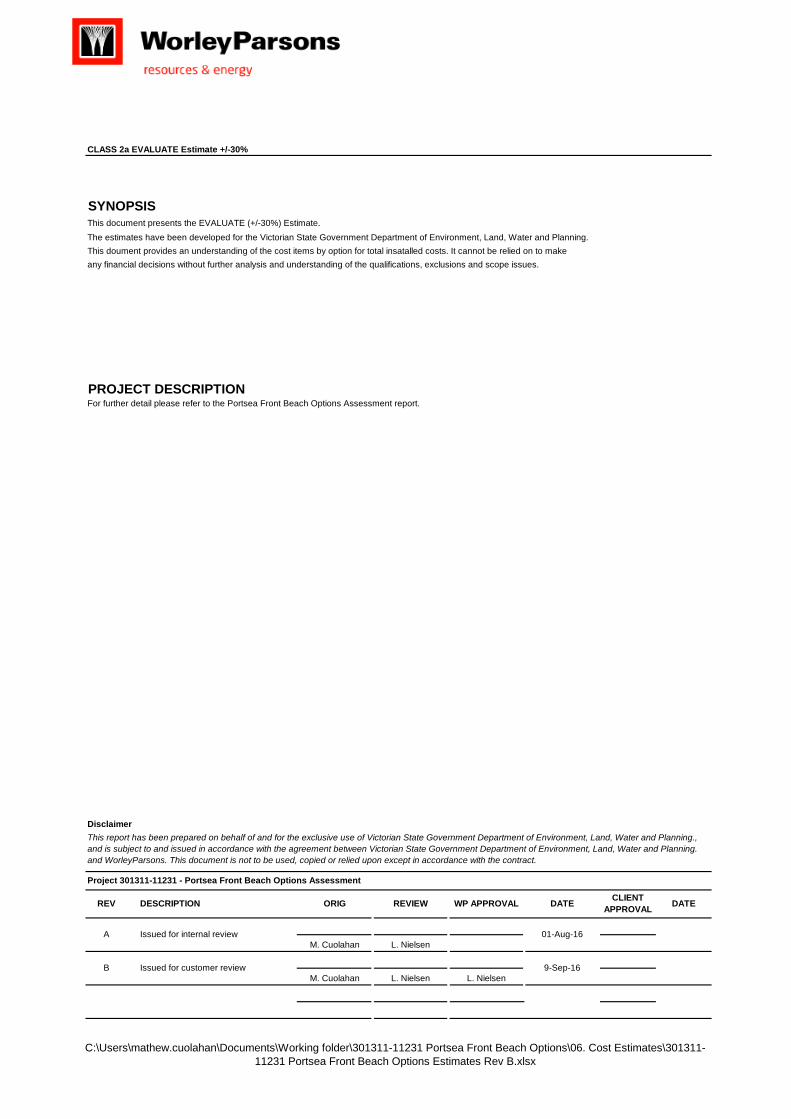
Figure 5. Shoreline Movement history at Point Franklin
60.0
70.0
80.0
90.0
100.0
110.0

Department of Environment,
Land, Water and Planning
Portsea Front Beach
Remediation
Long Term Options Assessment
Advisian 49
THIS PAGE LEFT BLANK

Department of Environment,
Land, Water and Planning
Portsea Front Beach
Remediation
Long Term Options Assessment
Costing Appendix C:

Department of Environment,
Land, Water and Planning
Portsea Front Beach
Remediation
Long Term Options Assessment
Advisian 51
THIS PAGE LEFT BLANK
C:\Users\mathew.cuolahan\Documents\Working folder\301311-11231 Portsea Front Beach Options\06. Cost Estimates\301311-11231 Portsea Front Beach Options Estimates Rev B.xlsx
CLASS 2a EVALUATE Estimate +/-30%
SYNOPSIS
PROJECT DESCRIPTION
Disclaimer
M. Cuolahan L. Nielsen
M. Cuolahan L. Nielsen L. Nielsen
Project 301311-11231 - Portsea Front Beach Options Assessment
For further detail please refer to the Portsea Front Beach Options Assessment report.
This report has been prepared on behalf of and for the exclusive use of Victorian State Government Department of Environment, Land, Water and Planning., and is subject to and issued in accordance with the agreement between Victorian State Government Department of Environment, Land, Water and Planning. and WorleyParsons. This document is not to be used, copied or relied upon except in accordance with the contract.
CLIENT APPROVAL DATEDESCRIPTION ORIG REVIEW WP APPROVAL DATEREV
B Issued for customer review 9-Sep-16
A Issued for internal review 01-Aug-16
This document presents the EVALUATE (+/-30%) Estimate.The estimates have been developed for the Victorian State Government Department of Environment, Land, Water and Planning.This doument provides an understanding of the cost items by option for total insatalled costs. It cannot be relied on to make any financial decisions without further analysis and understanding of the qualifications, exclusions and scope issues.
C:\Users\mathew.cuolahan\Documents\Working folder\301311-11231 Portsea Front Beach Options\06. Cost Estimates\301311-11231 Portsea Front Beach Options Estimates Rev B.xlsx Page 3
Date: 09-September-2016Rev: BBy: M. CuolahanChecked: L. Nielsen
1.0 Estimate Key Qualifications
1.01 Estimate accuracy is concept screening level (WOR EVALUATE phase) and based on conceptual information.
1.02 Estimate base date is July 2016.
1.03 Direct manual labour rates and unit rates are based on recent ‘typical’ historical data.
1.04 Labour productivities are based on historical data (PF @ 1.4)
1.05 No detailed Contract and Procurement plans have been developed as part of this estimate, therefore the estimate is based on typical.
1.06 No detail mobile piling, cranage & rigging studies were completed.
1.07 No geotechnical investigations were completed.
1.08 No formal logistics study has been completed.
1.09 No project or construction schedule developed to support estimate basis.
1.10 Estimate allows for EPCM execution. (Engineering, Procurement, Construction and Management)
1.11 Contracting Strategy is by Sub-Contracts.
1.12 Contingency was included as per WOR estimate classifications.
1.13 Estimate allows for Common Distirbutables Costs. This scope covers:
1.13.1 Temporary Construction facilities
1.13.2 Construction support
1.13.3 Inductions (Cost for manual labour to attend site specific inductions when not included in contractor distributable costs.)
2.00 Estimate Assumptions
2.01 Unit weight used in estimate for rock is 2.6 MT per CM.
2.02 Supply rate of rock armour (shot rock) is between $AUD 30 - 50 per MT - $AUD 35 per MT has been used.
2.03 Pricing will be subject to quantity purchased and location of hard rock quarry.
2.04 Dredging sub contractor distributlabes, accommodation, maintenance and fuel - Included in dredging rates
2.05 Dredging downtime for seastate i.e. environmental / Fish / Whale migration and inclement weather included.
2.06 Piling / sheet supply and install rates are from historical / contracted rates
2.07 The pricing reflects the cost of driving piles / sheets as per scope i.e. no ancillary work such as support work for precast, concreting of pile toes, etc. has not been costed.
2.08 The impact of shipping operations or beach use during summer has not been assessed or allowed for in the productivities used. Assume beach will be closed.
2.09 The assumptions made about the availability of works areas have not been validated.
2.10 A pile / sheet driving analysis has not been carried out .
2.11 Detailed methods, the sequence of construction and overall project program duration have not been evaluated as yet. As such the pricing does not reflect plant and labour balancing for the project durations,
2.12 Piles are assumed to be free issue at Portsea, within 1km of the site and can be road transported to site in full lengths.
2.13 Dredging Ship Mob assumed from local port.
2.14 Dredging rates are based on local historical data.
3.00 Estimate Exclusions
3.01 Variations to exchange rates other than those nominated in the estimate.
3.02 Owners costs is excluded.
3.03 No allowance for any variation to scope.
3.04 No allowances for deferred capital costs.
3.05 Finance and interest charges for project duration.
3.06 No allowance for salvage value for any demolished equipment and materials.
Portsea Front Beach Options AssessmentWORLEYPARSONS JOB NUMBER: 301311-11231
ESTIMATE BASIS EVALUATE Estimate +/-30% Location: Portsea, Victoria

C:\Users\mathew.cuolahan\Documents\Working folder\301311-11231 Portsea Front Beach Options\06. Cost Estimates\301311-11231 Portsea Front Beach Options Estimates Rev B.xlsx Page 4
3.07 Any special environmental requirements.
3.08 Costs of environmental testing.
3.09 Any environmental requirement not identified in this estimate.
3.10 Taxes / Import duties.
3.11 No allowance for abnormal land and seastate weather conditions.
3.12 No allowance has been made for soil remediation for any in situ contaminants if required.
3.13 No allowance has been included for extended periods of industrial unrest.
3.14 No allowance has been made for delay costs associated with obtaining statutory approvals
3.15 Sunk costs (eg. Cost of this and previous studies etc.)
3.16 Market forces & escalation.
3.17 Assessment of total direct manhours for dredging.
C:\Users\mathew.cuolahan\Documents\Working folder\301311-11231 Portsea Front Beach Options\06. Cost Estimates\301311-11231 Portsea Front Beach Options Estimates Rev B.xlsx Page 5
Date: 09-September-2016Revision: BOriginator: M. CuolahanChecked: L. NielsenCurrency: AUD
3 4 10 13 14 15 16 17 18 19 20 21 22 23
Item Major Commodities Qty UoM Unit Man Hrs Man Hours Labour
Rate Plant &
Equipment Vendor Reps Bulk Material Freight Labour Contractor Distribs
Const. Equipment
Sub Total Direct Cost
Common Distributables EPCM Costs Owner's Costs Contingency Escalation Sub Total
Indirect Costs Total Installed
Costs
DIRECT COSTS INDIRECT COSTS
A. Configuration Dredging Offshore 1 LOT 1,610 1,610 80 - - 44,993,018 29,942 128,800 346,840 5,579,800 51,078,400 2,553,920 7,661,760 - 15,323,520 - 25,539,200 76,617,600 67% 3% 10% 0% 20% 0% 33%
B. Detached Rubblemound Breakwater 1 LOT 5,221 5,221 80 - - 3,150,300 315,030 417,680 1,096,824 1,426,000 6,405,834 320,292 960,875 - 1,921,750 - 3,202,917 9,608,750 67% 3% 10% 0% 20% 0% 33%
C. Detached SPW Breakwater 1 LOT 11,717 11,717 80 - - 1,663,309 166,331 937,333 2,032,199 1,736,500 6,535,672 326,784 980,351 - 1,960,702 - 3,267,836 9,803,508 67% 3% 10% 0% 20% 0% 33%
D. Attached Rubblemound Breakwater 1 LOT 12,248 12,248 80 - - 6,790,750 679,075 979,800 1,878,640 12,103,750 22,432,015 1,121,601 3,364,802 - 6,729,605 - 11,216,008 33,648,023 67% 3% 10% 0% 20% 0% 33%
E. Portsea Front Beach Headline Rock Groyne 1 LOT 2,444 2,444 80 - - 7,322,625 125,063 195,500 696,900 1,207,500 9,547,588 477,379 1,432,138 - 2,864,276 - 4,773,794 14,321,381 67% 3% 10% 0% 20% 0% 33%
F. Port Franklin Headland Rock Groyne 1 LOT 2,846 2,846 80 - - 11,077,375 132,538 227,700 754,860 2,645,000 14,837,473 741,874 2,225,621 - 4,451,242 - 7,418,736 22,256,209 67% 3% 10% 0% 20% 0% 33%
G. Sand Nourishment 1 LOT 805 805 80 - - 21,240,500 14,950 64,400 230,920 2,150,500 23,701,270 1,185,064 3,555,191 - 7,110,381 - 11,850,635 35,551,905 67% 3% 10% 0% 20% 0% 33%
H. Rock Revetment 1 LOT 2,979 2,979 80 - - 876,875 87,688 238,317 543,970 28,750 1,775,600 88,780 266,340 - 532,680 - 887,800 2,663,399 67% 3% 10% 0% 20% 0% 33%
I. Rock Revetment with sand nourishment 1 LOT 3,784 3,784 80 - - 22,070,225 97,923 302,717 659,890 2,179,250 25,310,005 1,265,500 3,796,501 - 7,593,001 - 12,655,002 37,965,007 67% 3% 10% 0% 20% 0% 33%
J. Configuration Dredging Nearshore 1 LOT 1,400 1,400 92 - - 299,418 29,942 128,800 346,840 15,088,000 15,893,000 15,893,000 0% 0%
Portsea Front Beach Options AssessmentWORLEYPARSONS JOB NUMBER: 301311-11231
EVALUATE Estimate +/-30% Estimate Detailed Summary
SCOPE BASE UNIT RATES DIRECT COSTS (AUD)
C:\Users\mathew.cuolahan\Documents\Working folder\301311-11231 Portsea Front Beach Options\06. Cost Estimates\301311-11231 Portsea Front Beach Options Estimates Rev B.xlsx Page 6
Portsea Front Beach Options AssessmentWORLEYPARSONS JOB NUMBER: 301311-11231
ESTIMATE DETAILS BY COMMODITY EVALUATE Estimate +/-30% Location: Portsea, VictoriaDate: 09-September-2016Rev: BBy: M. CuolahanChecked: L. NielsenCurrency : AUD
1 2 3 4 5 6 7 8 9 10 11 12 13 14 15 16 17 18 19 20 21 22 23
Facility Pricing Basis
Quantity Basis
Commodity Code - Description
Details Qty UoM Unit Price, UP ($)
Base Unit Hrs, BUH
Loc. Factor,
LF
Prod. Factor,
PF
Unit Man hrs, UMH
Man hrs, MH
Labour Rate, LR
Contract.Distribs
(% of direct LC)
Plant & Equipment,
PE
Vendor Reps, VR
Bulk Material, BM
Freight, FC
Labour, LC
Contractor Distribs,
CD
Construction Equipment, CE
Total, TC=
Unit Cost (Cost Per
Unit)
% of TICs % of Direct Costs
DIRECT COSTS
A. Configuration Dredging Offshore
A CD Preliminaries (Included in Subcontractor Distribs) 1 LOT 100,000 - 1.00 1.40 - - 80.00 180% n/a - - - 100,000 - 100,000 100,000 0.0% 0.1%A CD Site Establishment/dis-establishment 1 LOT 370,000 - 1.00 1.40 - - 80.00 180% n/a - - - - 370,000 370,000 370,000 0.0% 0.2%
SD H CD Configuration Dredging/place sand on beach 300,000 CM 10 - 1.00 1.40 - - 80.00 180% n/a - - - - 3,000,000 3,000,000 10 0.0% 1.7%SC H CD Sidecasting 260,000 CM 5.70 - 1.00 1.40 - - 80.00 180% n/a - - - - 1,482,000 1,482,000 6 0.0% 0.8%
E CD Foredune planting and fencing 20,000 SM 13.02 0.05 1.00 1.40 0.07 1,400.0 80.00 180% n/a 260,364 26,036 112,000 201,600 - 600,000 30 0.0% 0.3%E CD Maintenance - redo every 6 years for 44 years 7 LOT 5,552,000 - 1.00 1.40 - - 80.00 180% n/a 38,864,000 - - - - 38,864,000 5,552,000 0.0% 21.9%
DA DA AZ - Site Development Allowances Design and Pricing Allowance - 15% 1 LOT 210.0 - - 5,868,655 3,905 16,800 45,240 727,800 6,662,400 6,662,400 0.0% 3.8%A. SITE SITE TOTAL 1 LOT 1,610.0 - - 44,993,018 29,942 128,800 346,840 5,579,800 51,078,400 51,078,400 0.0% 28.8%
B. Detached Rubblemound Breakwater
A CD Preliminaries (Included in Subcontractor Distribs) 1 LOT 300,000 - 1.00 1.40 - - 80.00 180% n/a - - - 300,000 - 300,000 300,000 0.0% 0.2%A CD Site Establishment/dis-establishment 1 LOT 400,000 - 1.00 1.40 - - 80.00 180% n/a - - - - 400,000 400,000 400,000 0.0% 0.2%
RF H CD Rock fill for breakwater core (2.6 MT per CM) 22,000 CM 91 0.05 1.00 1.40 0.07 1,540.0 80.00 180% n/a 2,002,000 200,200 123,200 221,760 - 2,547,160 116 0.0% 1.4%RA H CD Rock armouring (2.6 MT per CM) 5,300 CM 91 0.36 1.00 1.40 0.50 2,650.0 80.00 180% n/a 482,300 48,230 212,000 381,600 - 1,124,130 212 0.0% 0.6%SD H CD Sand dredging & placement on beach 84,000 CM 10 - 1.00 1.40 - - 80.00 180% n/a - - - - 840,000 840,000 10 0.0% 0.5%
E CD Foredune planting and fencing 5,000 SM 13.02 0.05 1.00 1.40 0.07 350.0 80.00 180% n/a 65,091 6,509 28,000 50,400 - 150,000 30 0.0% 0.1%A CD Marker piles 2 EA 60,000 - 1.00 1.40 - - 80.00 180% n/a 120,000 12,000 - - - 132,000 66,000 0.0% 0.1%A CD Rock work maintenance 1 LOT 70,000 - 1.00 1.40 - - 80.00 180% n/a 70,000 7,000 - - - 77,000 77,000 0.0% 0.0%
DA DA BZ - Earthworks Allowances Design and Pricing Allowance - 15% 1 LOT 681.0 - - 410,909 41,091 54,480 143,064 186,000 835,544 835,544 0.0% 0.5%B. EARTH EARTH TOTAL 1 LOT 5,221.0 - - 3,150,300 315,030 417,680 1,096,824 1,426,000 6,405,834 6,405,834 0.0% 3.6%
C. Detached SPW Breakwater
A CD Preliminaries (Included in Subcontractor Distribs) 1 LOT 300,000 - 1.00 1.40 - - 80.00 180% n/a - - - 300,000 - 300,000 300,000 0.0% 0.2%A CD Site Establishment/dis-establishment 1 LOT 670,000 - 1.00 1.40 - - 80.00 180% n/a - - - - 670,000 670,000 670,000 0.0% 0.4%H CD Supply & install AZ14-770 SPW 260 MT 2,741 2.53 1.00 1.40 3.54 920.4 80.00 180% n/a 712,660 71,266 73,632 132,538 - 990,096 3,808 0.0% 0.6%H CD Pile Cut off 190 EA - 5.00 1.00 1.40 7.00 1,330.0 80.00 180% n/a - - 106,400 191,520 - 297,920 1,568 0.0% 1.3%H CD Supply 12m long CHS460x16x174kg/m piles 88 MT 2,242 - 1.00 1.40 - - 80.00 180% n/a 197,296 19,730 - - - 217,026 2,466 0.0% 0.1%H CD Install raker piles 504 LM - 5.50 1.00 1.40 7.70 3,880.8 80.00 180% n/a - - 310,464 558,835 - 869,299 1,725 0.0% 0.5%H CD Pile Cut off 42 EA - 10.00 1.00 1.40 14.00 588.0 80.00 180% n/a - - 47,040 84,672 - 131,712 3,136 0.0% 0.1%H CD Supply/Install 400 m 310UBPx110kg/m walers 44 MT 5,600 22.00 1.00 1.40 30.80 1,355.2 80.00 180% n/a 246,400 24,640 108,416 195,149 - 574,605 13,059 0.0% 0.3%E CD Supply/install fabricated steel pin joints 42 EA 2,500 30.00 1.00 1.40 42.00 1,764.0 80.00 180% n/a 105,000 10,500 141,120 254,016 - 510,636 12,158 0.0% 0.3%
SD H CD Sand dredging & placement on beach 84,000 CM 10 - 1.00 1.40 - - 80.00 180% n/a - - - - 840,000 840,000 10 0.0% 0.5%E CD Foredune planting and fencing 5,000 SM 13 0.05 1.00 1.40 0.07 350.0 80.00 180% n/a 65,000 6,500 28,000 50,400 - 149,900 30 0.0% 0.1%A CD Marker piles 2 EA 60,000 - 1.00 1.40 - - 80.00 180% n/a 120,000 12,000 - - - 132,000 66,000 0.0% 0.1%
DA DA CZ - Concrete Allowances Design and Pricing Allowance - 15% 1 LOT 1,528.3 - - 216,953.40 21,695.34 122,260.80 265,069.44 226,500 852,479 852,479 0.0% 0.5%C. CONCRETE CONCRETE TOTAL 1 LOT 11,716.7 - - 1,663,309 166,331 937,333 2,032,199 1,736,500 6,535,672 6,535,672 0.0% 3.7%
D. Attached Rubblemound Breakwater
A CD Preliminaries (Included in Subcontractor Distribs) 1 LOT 100,000 - 1.00 1.40 - - 80.00 180% n/a - - - 100,000 - 100,000 100,000 0.0% 0.1%A CD Site Establishment/dis-establishment 1 LOT 25,000 - 1.00 1.40 - - 80.00 180% n/a - - - - 25,000 25,000 25,000 0.0% 0.0%H CD Supply and place rock fill (2.6 MT per CM) 45,000 CM 91 0.05 1.00 1.40 0.07 3,150.0 80.00 180% n/a 4,095,000 409,500 252,000 453,600 - 5,210,100 116 0.0% 2.9%
RA H CD Supply and place rock armour (2.6 MT per CM) 15,000 CM 91 0.36 1.00 1.40 0.50 7,500.0 80.00 180% n/a 1,365,000 136,500 600,000 1,080,000 - 3,181,500 212 0.0% 1.8%A CD Maintenance of rock armour 1 LOT 325,000 1.00 1.40 - - 80.00 180% n/a 325,000 32,500 - - - 357,500 357,500 0.0% 0.2%A CD sand bypassing 350,000 CM 30 1.00 1.40 - - 80.00 180% n/a - - - - 10,500,000 10,500,000 30 0.0% 5.9%A CD Marker Piles 2 EA 60,000 1.00 1.40 - - 80.00 180% n/a 120,000 12,000 - - - 132,000 66,000 0.0% 0.1%
DA DA DZ - Structural Steel Allowances Design and Pricing Allowance - 15% 1 LOT 1,597.5 - - 885,750 88,575 127,800 245,040 1,578,750 2,925,915 2,925,915 0.0% 1.6%D. STEEL STEEL TOTAL 1 LOT 12,247.5 - - 6,790,750 679,075 979,800 1,878,640 12,103,750 22,432,015 22,432,015 0.0% 12.6%
E. Portsea Front Beach Headline Rock Groyne
A CD Preliminaries (Included in Subcontractor Distribs) 1 LOT 300,000 - 1.00 1.40 - - 80.00 180% n/a - - - 300,000 - 300,000 300,000 0.0% 0.2%A CD Site Establishment/dis-establishment 1 LOT 400,000 - 1.00 1.40 - - 80.00 180% n/a - - - - 400,000 400,000 400,000 0.0% 0.2%H CD Supply and place rock fill (2.6 MT per CM) 7,500 CM 91 0.05 1.00 1.40 0.07 525.0 80.00 180% n/a 682,500 68,250 42,000 75,600 - 868,350 116 0.0% 0.5%
RA H CD Supply and place rock armour (2.6 MT per CM) 2,500 CM 91 0.36 1.00 1.40 0.50 1,250.0 80.00 180% n/a 227,500 22,750 100,000 180,000 - 530,250 212 0.0% 0.3%SD H CD Dredge and place sand 65,000 CM 10 - 1.00 1.40 - - 80.00 180% n/a - - - - 650,000 650,000 10 0.0% 0.4%
E CD Foredune planting and fencing 5,000 SM 13 0.05 1.00 1.40 0.07 350.0 80.00 180% n/a 65,000 6,500 28,000 50,400 - 149,900 30 0.0% 0.1%A CD Nav aid 1 EA 60,000 1.00 1.40 - - 80.00 180% n/a 60,000 6,000 - - - 66,000 66,000 0.0% 0.0%A CD Rock armour maintenance 1 LOT 52,500 1.00 1.40 - - 80.00 180% n/a 52,500 5,250 - - - 57,750 57,750 0.0% 0.0%A CD Sand maintenance 1 LOT 5,280,000 1.00 1.40 - - 80.00 180% n/a 5,280,000 - - - - 5,280,000 5,280,000 0.0% 3.0%
DA DA FZ - Building Allowances Design and Pricing Allowance - 15% 1 LOT 318.8 - - 955,125 16,312.50 25,500 90,900 157,500 1,245,338 1,245,338 0.0% 0.7%F. BUILD BUILD TOTAL 1 LOT 2,443.8 - - 7,322,625 125,063 195,500 696,900 1,207,500 9,547,588 9,547,588 0.0% 5.4%
F. Port Franklin Headland Rock Groyne
A CD Preliminaries (Included in Subcontractor Distribs) 1 LOT 300,000 - 1.00 1.40 - - 80.00 180% n/a - - - 300,000 - 300,000 300,000 0.0% 0.2%A CD Site Establishment/dis-establishment 1 LOT 400,000 - 1.00 1.40 - - 80.00 180% n/a - - - - 400,000 400,000 400,000 0.0% 0.2%H CD Supply and place rock fill (2.6 MT per CM) 7,500 CM 91 0.05 1.00 1.40 0.07 525.0 80.00 180% n/a 682,500 68,250 42,000 75,600 - 868,350 116 0.0% 0.5%
RA H CD Supply and place rock armour (2.6 MT per CM) 2,500 CM 91 0.36 1.00 1.40 0.50 1,250.0 80.00 180% n/a 227,500 22,750 100,000 180,000 - 530,250 212 0.0% 0.3%
%SCOPE UNIT RATE, (Units) COSTS, ($)

C:\Users\mathew.cuolahan\Documents\Working folder\301311-11231 Portsea Front Beach Options\06. Cost Estimates\301311-11231 Portsea Front Beach Options Estimates Rev B.xlsx Page 7
Portsea Front Beach Options AssessmentWORLEYPARSONS JOB NUMBER: 301311-11231
ESTIMATE DETAILS BY COMMODITY EVALUATE Estimate +/-30% Location: Portsea, VictoriaDate: 09-September-2016Rev: BBy: M. CuolahanChecked: L. NielsenCurrency : AUD
1 2 3 4 5 6 7 8 9 10 11 12 13 14 15 16 17 18 19 20 21 22 23
Facility Pricing Basis
Quantity Basis
Commodity Code - Description
Details Qty UoM Unit Price, UP ($)
Base Unit Hrs, BUH
Loc. Factor,
LF
Prod. Factor,
PF
Unit Man hrs, UMH
Man hrs, MH
Labour Rate, LR
Contract.Distribs
(% of direct LC)
Plant & Equipment,
PE
Vendor Reps, VR
Bulk Material, BM
Freight, FC
Labour, LC
Contractor Distribs,
CD
Construction Equipment, CE
Total, TC=
Unit Cost (Cost Per
Unit)
% of TICs % of Direct Costs
%SCOPE UNIT RATE, (Units) COSTS, ($)
SD H CD Dredge and place sand 190,000 CM 10 - 1.00 1.40 - - 80.00 180% n/a - - - - 1,900,000 1,900,000 10 0.0% 1.1%E CD Foredune planting and fencing 10,000 SM 13 0.05 1.00 1.40 0.07 700.0 80.00 180% n/a 130,000 13,000 56,000 100,800 - 299,800 30 0.0% 0.2%A CD Maintenance Beach Nourishment 1 LOT 8,480,000 1.00 1.40 - - 80.00 180% n/a 8,480,000 - - - - 8,480,000 8,480,000 0.0% 4.8%A CD Rock armour maintenance 1 LOT 52,500 1.00 1.40 - - 80.00 180% n/a 52,500 5,250 - - - 57,750 57,750 0.0% 0.0%A CD Nav aid 1 EA 60,000 1.00 1.40 - - 80.00 180% n/a 60,000 6,000 - - - 66,000 66,000 0.0% 0.0%
DA DA GZ - Miscellaneous Design and Pricing Allowance - 15% 1 LOT 371.3 - - 1,444,875 17,288 29,700 98,460 345,000 1,935,323 1,935,323 0.0% 1.1%G. SCAFF SCAFF TOTAL 1 LOT 2,846.3 - - 11,077,375 132,538 227,700 754,860 2,645,000 14,837,473 14,837,473 0.0% 8.4%
G. Sand Nourishment
A CD Preliminaries (Included in Subcontractor Distribs) 1 LOT 100,000 - 1.00 1.40 - - 80.00 180% n/a - - - 100,000 - 100,000 100,000 0.0% 0.1%A CD Site Establishment/dis-establishment 1 LOT 370,000 - 1.00 1.40 - - 80.00 180% n/a - - - - 370,000 370,000 370,000 0.0% 0.2%
SD H CD Dredge and place sand 150,000 CM 10 - 1.00 1.40 - - 80.00 180% n/a - - - - 1,500,000 1,500,000 10 0.0% 0.8%E CD Foredune planting and fencing 10,000 SM 13 0.05 1.00 1.40 0.07 700.0 80.00 180% n/a 130,000 13,000 56,000 100,800 - 299,800 30 0.0% 0.2%A CD Maintenance (next 40 years) 1 LOT 18,340,000 - 1.00 1.40 - - 80.00 180% n/a 18,340,000 - - - - 18,340,000 18,340,000 0.0% 10.3%
1.00 1.40 - - 80.00 180% n/a - - - - - - - 0.0% 0.0%DA DA HZ - Handling Equipment
Allowances Design and Pricing Allowance - 15% 1 LOT 105.0 - - 2,770,500 1,950 8,400 30,120 280,500 3,091,470 3,091,470 0.0% 1.7%H. MOD MOD TOTAL 1 LOT 805.0 - - 21,240,500 14,950 64,400 230,920 2,150,500 23,701,270 23,701,270 0.0% 13.4%
H. Rock Revetment
A CD Preliminaries (Included in Subcontractor Distribs) 1 LOT 100,000 - 1.00 1.40 - - 80.00 180% n/a - - - 100,000 - 100,000 100,000 0.0% 0.1%A CD Site Establishment/dis-establishment 1 LOT 25,000 - 1.00 1.40 - - 80.00 180% n/a - - - - 25,000 25,000 25,000 0.0% 0.0%
RA H CD Supply and place rock armour (2.6 MT per CM) 4,100 CM 91 0.36 1.00 1.40 0.50 2,050.0 80.00 180% n/a 373,100 37,310 164,000 295,200 - 869,610 212 0.0% 0.5%H CD Supply and place rock underlayer (2.6 MT per CM) 1,100 CM 91 0.10 1.00 1.40 0.14 154.0 80.00 180% n/a 100,100 10,010 12,320 22,176 - 144,606 131 0.0% 0.1%E CD Supply and place gtx 2,300 SM 11 0.12 1.00 1.40 0.17 386.4 80.00 180% n/a 25,300 2,530 30,912 55,642 - 114,384 50 0.0% 0.1%A CD Rock armour maintenance 1 LOT 264,000 - 1.00 1.40 - - 80.00 180% n/a 264,000 26,400 - - - 290,400 290,400 0.0% 0.2%
DA DA JZ - Jetties Allowance Design and Pricing Allowance - 15% 1 LOT 388.6 - - 114,375 11,437.50 31,084.80 70,952.64 3,750 231,600 231,600 0.0% 0.1%J. JETT JETT TOTAL 1 LOT 2,979.0 - - 876,875 87,688 238,317 543,970 28,750 1,775,600 1,775,600 0.0% 1.0%
I. Rock Revetment with sand nourishment
A CD Preliminaries (Included in Subcontractor Distribs) 1 LOT 100,000 - 1.00 1.40 - - 80.00 180% n/a - - - 100,000 - 100,000 100,000 0.0% 0.1%A CD Site Establishment/dis-establishment 1 LOT 25,000 - 1.00 1.40 - - 80.00 180% n/a - - - - 25,000 25,000 25,000 0.0% 0.0%
RA H CD Supply and place rock armour (2.6 MT per CM) 4,100 CM 91 0.36 1.00 1.40 0.50 2,050.0 80.00 180% n/a 373,100 37,310 164,000 295,200 - 869,610 212 0.0% 0.5%H CD Supply and place rock underlayer (2.6 MT per CM) 1,100 CM 91 0.10 1.00 1.40 0.14 154.0 80.00 180% n/a 100,100 10,010 12,320 22,176 - 144,606 131 0.0% 0.1%E CD Supply and place gtx 2,300 CM 11 0.12 1.00 1.40 0.17 386.4 80.00 180% n/a 25,300 2,530 30,912 55,642 - 114,384 50 0.0% 0.1%A CD Rock armour maintenance 1 LOT 223,000 1.00 1.40 - - 80.00 180% n/a 223,000 22,300 - - - 245,300 245,300 0.0% 0.1%A CD Establishment for nourishment 1 LOT 370,000 1.00 1.40 - - 80.00 180% n/a - - - - 370,000 370,000 370,000 0.0% 0.2%
SD H CD Dredge and place sand 150,000 CM 10 - 1.00 1.40 - - 80.00 180% n/a - - - - 1,500,000 1,500,000 10 0.0% 0.8%E CD Foredune planting and fencing 10,000 SM 13 0.05 1.00 1.40 0.07 700.0 80.00 180% n/a 130,000 13,000 56,000 100,800 - 299,800 30 0.0% 0.2%A CD Sand maintenance next 40 years 1 LOT 18,340,000 - 1.00 1.40 - - 80.00 180% n/a 18,340,000 - - - - 18,340,000 18,340,000 0.0% 10.3%
DA DA KZ - Turnkey packages Allowances Design and Pricing Allowance - 15% 1 LOT 493.6 - - 2,878,725 12,772.50 39,484.80 86,072.64 284,250 3,301,305 3,301,305 0.0% 1.9%K.TURNKEY TURNKEY TOTAL 1 LOT 3,784.0 - - 22,070,225 97,923 302,717 659,890 2,179,250 25,310,005 25,310,005 0.0% 14.3%
J. Configuration Dredging Nearshore
A CD Preliminaries (Included in Subcontractor Distribs) 1 LOT 100,000 - 1.00 1.40 - - 80.00 180% n/a - - - 100,000 - 100,000 100,000 0.0% 0.1%A CD Site Establishment/dis-establishment 1 LOT 370,000 - 1.00 1.40 - - 80.00 180% n/a - - - - 370,000 370,000 370,000 0.0% 0.2%H CD Configuration Dredging/place sand on beach (1500 CM per hr) 200,000 CM 10 - 1.00 1.40 - - 80.00 180% n/a - - - - 2,000,000 2,000,000 10 0.0% 1.1%H CD Dredge hardpan, sidecast and sweep 430,000 CM 25 - 1.00 1.40 - - 80.00 180% n/a - - - - 10,750,000 10,750,000 25 0.0% 6.1%E CD Foredune planting and fencing 20,000 SM 13.02 0.05 1.00 1.40 0.07 1,400.0 80.00 180% n/a 260,364 26,036 112,000 201,600 - 600,000 30 0.0% 0.3%
DA DA LZ - Insulation Allowances Design and Pricing Allowance - 15% 1.0 LOT - - - 39,054.55 3,905.45 16,800 45,240 1,968,000 2,073,000 2,073,000 0.0% 1.2%L. INSULATION INSULATION TOTAL 1 LOT 1,400.0 - - 299,418 29,942 128,800 346,840 15,088,000 15,893,000 15,893,000 0.0% 9.0%

Department of Environment,
Land, Water and Planning
Portsea Front Beach
Remediation
Long Term Options Assessment
Marine Ecology Appendix D:

Department of Environment,
Land, Water and Planning
Portsea Front Beach
Remediation
Long Term Options Assessment
Advisian 53
THIS PAGE LEFT BLANK
Department of Environment,
Land, Water and Planning
Portsea Front Beach
Remediation
Appendix D: Marine Ecology
Project No: 301311-11231- – Portsea Front Beach Remediation: Appendix
D: Marine Ecology
Rev Description Author Review
Advisian
Approval Date
A Draft
HH
AFN
AFN
9 Sept 2016
0 Final
HH
AFN
AFN
16 November
2016
Department of Environment,
Land, Water and Planning
Portsea Front Beach
Remediation
Appendix D: Marine Ecology
Contents
1 Introduction ........................................................................................................................... 1
2 Methods .................................................................................................................................. 2
2.1 Field ............................................................................................................................. 2
2.2 Survey Transects ..................................................................................................... 3
2.3 Data Analysis ............................................................................................................ 3
3 Results ...................................................................................................................................... 4
3.1 Transect 1 .................................................................................................................. 4
3.2 Transect 2 .................................................................................................................. 4
3.3 Transect 3 .................................................................................................................. 5
3.4 Transect 4 .................................................................................................................. 5
3.5 Transect 5 .................................................................................................................. 6
3.6 Transect 6 .................................................................................................................. 7
3.7 Transect 7 .................................................................................................................. 7
3.8 Transect 8 .................................................................................................................. 8
3.9 Transect 9 .................................................................................................................. 8
3.10 Summary ................................................................................................................... 9
4 Initial Assessment of Impacts ........................................................................................ 10
4.1 Configuration Dredging ..................................................................................... 10
4.2 Breakwaters ............................................................................................................ 10
4.2.1 Detached Breakwater.........................................................................................10
4.2.2 Attached Breakwater Option ..........................................................................11
4.3 Groynes .................................................................................................................... 11
4.3.1 Point Franklin Groyne ........................................................................................11

Department of Environment,
Land, Water and Planning
Portsea Front Beach
Remediation
Appendix D: Marine Ecology
4.3.2 Portsea Front Beach Groyne ...........................................................................11
4.4 Beach Renourishment......................................................................................... 11
4.5 Rock Revetment .................................................................................................... 12
4.6 Summary of Potential Impact .......................................................................... 12
5 Regulatory Requirements ............................................................................................... 13
5.1 Coastal Management Act Consent ................................................................ 13
5.1.1 Preliminary Assessment ....................................................................................13
5.1.2 Process and Timeframe .....................................................................................13
5.1.3 Supporting Technical Studies Required .....................................................13
5.2 Environment Effects Act 1978 .......................................................................... 14
5.2.1 Preliminary Assessment ....................................................................................14
5.2.2 Process and Timeframe .....................................................................................14
5.3 Other Considerations .......................................................................................... 16
6 Conclusions .......................................................................................................................... 17
Appendices
Appendix A: Fieldwork Records
Figures
Figure 1. Towed Video System ......................................................................................................................................... 2
Figure 2. Towed video transects derived from GPS (indicated by the orange lines) .................................. 3
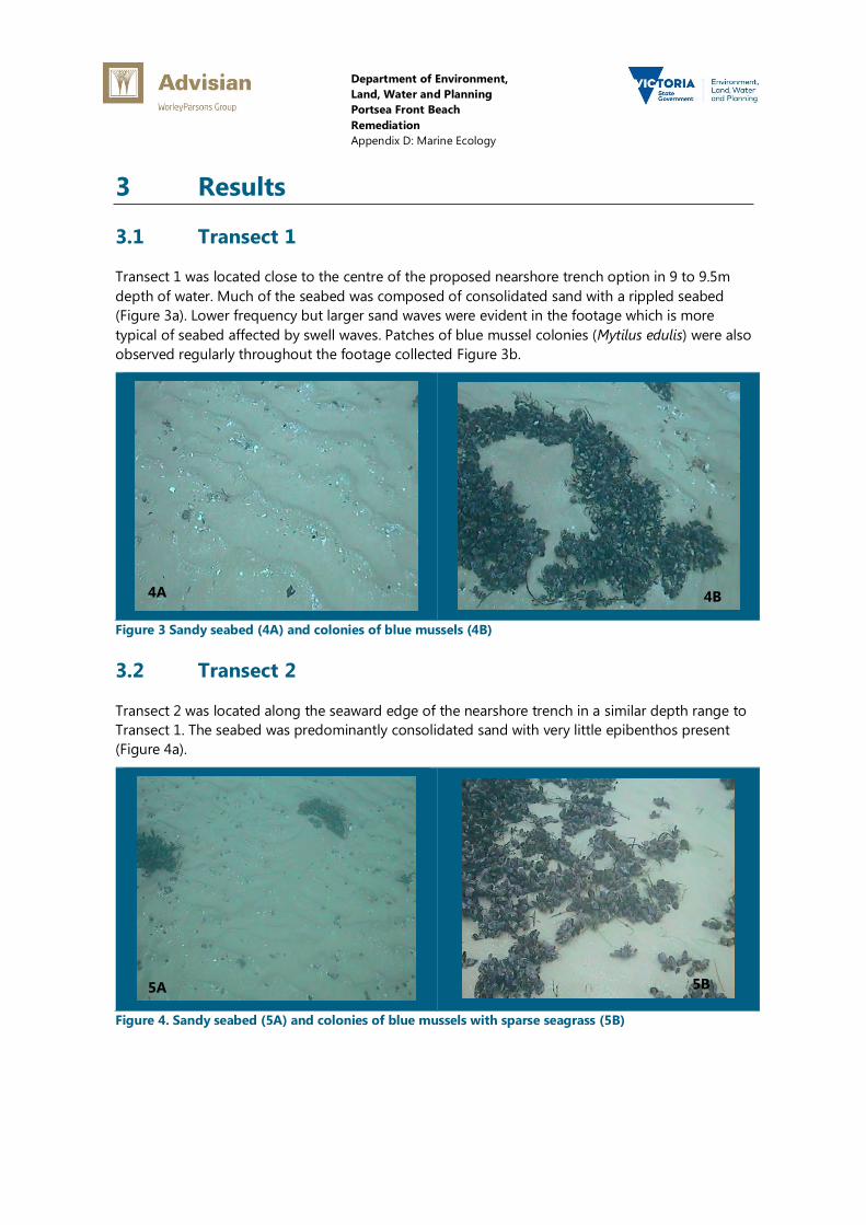
Figure 3 Sandy seabed (4A) and colonies of blue mussels (4B) .......................................................................... 4
Figure 4. Sandy seabed (5A) and colonies of blue mussels with sparse seagrass (5B) .............................. 4
Figure 5. Colonies of blue mussels (6A) and sandy seabed with shell (6B) .................................................... 5
Figure 6. Sandy seabed with light cover of macroalgae (7A) reef with dense cover of macroalgae
(7B) ............................................................................................................................................................................................... 6
Department of Environment,
Land, Water and Planning
Portsea Front Beach
Remediation
Appendix D: Marine Ecology
Figure 7. Macroalgae dominated reef at Point Franklin (8A) mixed seagrass/ macroalgae
assemblage (8B) ...................................................................................................................................................................... 6
Figure 8. Ecklonia macroalgae and Amphibolis seagrass (9A) mixed macroalgae assemblage (9B)..... 7
Figure 9. Point Franklin Reef, Ecklonia macroalgae (10A) rocky reef with sponges and macroalgae
(10B) ............................................................................................................................................................................................ 7
Figure 10. inshore section of transect 8 (11A) midway section of transect 8 (11B) ..................................... 8
Figure 11. Mixed mussels, seagrass and algae (12A) toward end of transect 9 (12B). ............................... 9
Tables
Table 1. Options Assessed in the Long Term Options Assessment Report .................................................... 1
Table 2 Summary of impact on existing habitat associated with each option ........................................... 12
Department of Environment,
Land, Water and Planning
Portsea Front Beach
Remediation
Appendix D: Marine Ecology
1 Introduction
Severe erosion at Portsea Front Beach in recent times has resulted from changes to the distribution
of wave energy along the Weeroona Bay foreshore.
The options considered in the main investigative report to ameliorate the erosion process at
Portsea Front Beach can be summarised as follows:
Table 1. Options Assessed in the Long Term Options Assessment Report
No. Option Description
1. Configuration Dredging Modify the distribution of wave energy along the Portsea Front
Beach shoreline to minimise erosion by shaping the seabed
with dredging. Dredged material could be used to restore the
beach.
2. Breakwaters This is a shore-parallel structure offshore of Portsea Pier that
would block the incoming swell wave energy that is causing
erosion at Portsea Front Beach. This includes consideration of
an attached and detached breakwater option.
3. Groynes A structure extending seaward from the shore that would
capture sand drift to the east, thereby building the beach and
providing a sand buffer to erosion. This includes consideration
of two options, one at Point Franklin and a second option
along the beach.
4. Replace sandbag revetment
with a rock revetment
A rock revetment would halt recession of the shoreline.
5. Beach restoration with sand
nourishment
The periodic placement of sand mined from the offshore sand
banks to feed the erosion process.
6. Remove sandbag revetment This explores what would be the extent of erosion that could
occur if no remedial works are undertaken.
This marine ecology report provides a description of the nearshore benthic environment that
potentially may be affected by the options assessed in the long term options assessment report.

Department of Environment,
Land, Water and Planning
Portsea Front Beach
Remediation
Appendix D: Marine Ecology
2 Methods
2.1 Field
The field assessment was undertaken on the 23rd
August 2016. Conditions on the day of survey
were ideal with very light winds and no swell. Underwater visibility was also exceptional with the
seabed visible at most sites to 8m (vertical) depth.
The survey vessel used was operated by the skipper at a speed between 1 and 2 knots while an
Advisian marine scientist was operating the underwater camera system to collect the required
video data. To ensure good quality of the recorded images, priority was given to vessel speed over
heading direction.
Before deploying the camera system, the coordinates of the centre point for the configuration
dredging option were entered into the on-board GPS to assist the skipper with orientation during
navigation. Video footage was collected along directional transect grids to survey the proposed
study area. A high definition underwater tow camera system with live feed was used to document
the conditions on the seabed (Figure 1). Underwater visibility was excellent and the camera was
towed at between 0.5m and 1.0m off the seabed.
Figure 1. Towed Video System
Department of Environment,
Land, Water and Planning
Portsea Front Beach
Remediation
Appendix D: Marine Ecology
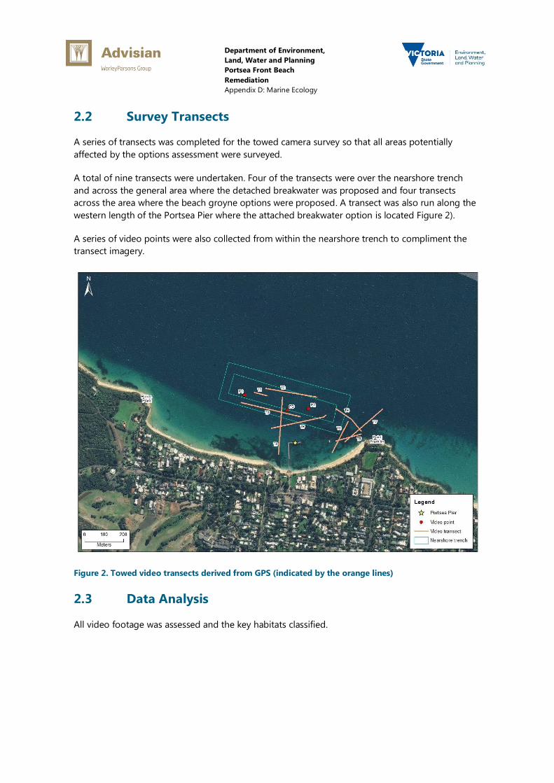
2.2 Survey Transects
A series of transects was completed for the towed camera survey so that all areas potentially
affected by the options assessment were surveyed.
A total of nine transects were undertaken. Four of the transects were over the nearshore trench
and across the general area where the detached breakwater was proposed and four transects
across the area where the beach groyne options were proposed. A transect was also run along the
western length of the Portsea Pier where the attached breakwater option is located Figure 2).
A series of video points were also collected from within the nearshore trench to compliment the
transect imagery.
Figure 2. Towed video transects derived from GPS (indicated by the orange lines)
2.3 Data Analysis
All video footage was assessed and the key habitats classified.
Department of Environment,
Land, Water and Planning
Portsea Front Beach
Remediation
Appendix D: Marine Ecology
3 Results
3.1 Transect 1
Transect 1 was located close to the centre of the proposed nearshore trench option in 9 to 9.5m
depth of water. Much of the seabed was composed of consolidated sand with a rippled seabed
(Figure 3a). Lower frequency but larger sand waves were evident in the footage which is more
typical of seabed affected by swell waves. Patches of blue mussel colonies (Mytilus edulis) were also
observed regularly throughout the footage collected Figure 3b.
Figure 3 Sandy seabed (4A) and colonies of blue mussels (4B)
3.2 Transect 2
Transect 2 was located along the seaward edge of the nearshore trench in a similar depth range to
Transect 1. The seabed was predominantly consolidated sand with very little epibenthos present
(Figure 4a).
Figure 4. Sandy seabed (5A) and colonies of blue mussels with sparse seagrass (5B)
4A 4B
5A 5B

Department of Environment,
Land, Water and Planning
Portsea Front Beach
Remediation
Appendix D: Marine Ecology
Patches of the blue mussel, Mytilus edulis, were common and varied in abundance and cover. A
very sparse cover of seagrass was also present in some of the footage (Figure 4b). The species
present was most likely Zostera nigricaulis, which is the most common seagrass species recorded in
Port Phillip Bay.
3.3 Transect 3
Transect 3 was located along the landward edge of the nearshore trench and in the general vicinity
of the detached breakwater option in 8.5 to 9.2m water depth. The habitat observed along
Transect 3 was very similar to that observed in Transect 1 and 2, although no seagrass was
detected in the footage.
Figure 5. Colonies of blue mussels (6A) and sandy seabed with shell (6B)
3.4 Transect 4
Transect 4 was located from the easterly end of nearshore trench toward Point Franklin and
followed the approximate alignment of the groyne at Point Franklin option. The seaward end of
the transect was in 10m water depth and shallowed with increasing proximity to Point Franklin. The
initial section of the transect was sand (Figure 6a) which then progressively changed into substrate
dominated by macroalgal reef (Figure 6b). The Point Franklin site has been monitored as part of
the Victorian Subtidal Reef Monitoring Program for Parks Victoria and has been surveyed by
Edmunds et al. (2003).
The most dominant algae at Point Franklin that was observed in the video footage was the kelp
Ecklonia radiata and to a lesser extent other brown algae such as Cystophora and Sargassum
species. Common invertebrates include the sea urchin Heliocidaris erythrogramma, the feather star
Cenolia trichoptera and very low abundances of abalone Haliotis spp. (Edmunds et al. 2003).
Fish were not observed in any of the footage at Point Franklin and Edmunds et. al. (2003)
confirmed that the Point Franklin reef had very low abundances of all fish species, including the
typically abundant blue throat wrasse, Notolabrus tetricus. The only observed species in higher
6A 6B

Department of Environment,
Land, Water and Planning
Portsea Front Beach
Remediation
Appendix D: Marine Ecology
abundance were the small species such as mado Atypichthys strigatus and juvenile toothbrush
leatherjackets Acanthaluteres vittiger. Edmunds et al. (2003) also indicated that the Point Franklin
site is subject to exceptional line and spear fishing pressure, with casual observations indicating the
site is likely to have the highest spear-fishing pressure in Victoria. The location is frequented by
novice fishers and indiscriminate spearing may have resulted in the observed paucity of all fish
species. At least two snorkelers were observed at Point Franklin during the field visit.
Figure 6. Sandy seabed with light cover of macroalgae (7A) reef with dense cover of macroalgae (7B)
3.5 Transect 5
Transect 5 was started at Point Franklin and completed 200 m westward toward Portsea Pier in 4 m
water depth. The transect commenced over reef and then intersected a mixed assemblage habitat
that was dominated by seagrass and macroalgae. The seagrass observed at the site was
predominantly Amphibolis antarctica which within Port Phillip Bay is usually restricted to the more
exposed locations around the Heads. Seagrass cover was patchy but dense (Figure 7b). These areas
of high density are clearly visible in the aerial imagery from the site.
Figure 7. Macroalgae dominated reef at Point Franklin (8A) mixed seagrass/ macroalgae assemblage
(8B)
7A 7B
8A 8B
Department of Environment,
Land, Water and Planning
Portsea Front Beach
Remediation
Appendix D: Marine Ecology
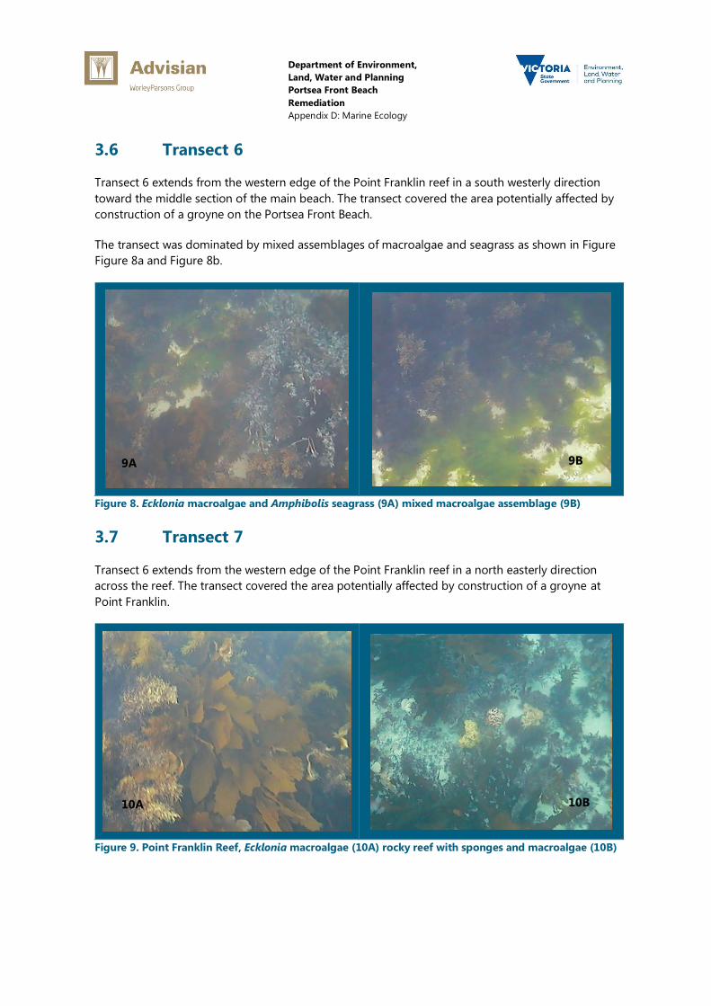
3.6 Transect 6
Transect 6 extends from the western edge of the Point Franklin reef in a south westerly direction
toward the middle section of the main beach. The transect covered the area potentially affected by
construction of a groyne on the Portsea Front Beach.
The transect was dominated by mixed assemblages of macroalgae and seagrass as shown in Figure
Figure 8a and Figure 8b.
Figure 8. Ecklonia macroalgae and Amphibolis seagrass (9A) mixed macroalgae assemblage (9B)
3.7 Transect 7
Transect 6 extends from the western edge of the Point Franklin reef in a north easterly direction
across the reef. The transect covered the area potentially affected by construction of a groyne at
Point Franklin.
Figure 9. Point Franklin Reef, Ecklonia macroalgae (10A) rocky reef with sponges and macroalgae (10B)
9A 9B
10A 10B

Department of Environment,
Land, Water and Planning
Portsea Front Beach
Remediation
Appendix D: Marine Ecology
A review of the footage showed that the habitat was predominantly reef (Figure 9) with mixed
assemblages of seagrass and macroalgae as described previously in Section 3.4. The seabed is
colonised by dense Amphibolis, a seagrass that forms meadows on calcareous sands, the
interweaving roots and leaves of which consolidate the substrate, protecting it from erosion by
currents and waves. Only toward the end of the transect, in approximately 10m water depth does
the substrate revert to a more sand dominated seabed.
3.8 Transect 8
Transect 7 was run in a northerly direction from the shallows immediately west of the existing Pier,
from a starting depth of 2.3 m to an end depth of 8.0 m This transect was intended to cover the
approximate alignment of the western wing associated with the attached breakwater option.
The initial section of transect was dominated by a mixed assemblage of seagrass and macroalgae.
The presence of the Amphibolis seagrass and macroalgae would indicate the presence of a hard
substrate for attachment like shell and broken rubble. No high relief reef was observed but is likely
to be present closer to shore where a small section of intertidal reef is visible at the base of the
seawall immediately west of the Pier. The inshore section of seagrass and macroalgae (Figure 10a)
eventually grades into unvegetated, sandy seabed at approximately 3.6 m depth (Figure 10b).
Toward the end of the transect, patches of blue mussel become more evident.
Figure 10. inshore section of transect 8 (11A) midway section of transect 8 (11B)
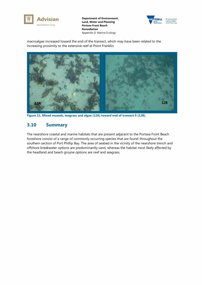
3.9 Transect 9
The final transect was run in a west to east direction, approximately 100m from the end of the
Portsea Pier at depths of 5.5m to 7.0m. This transect was intended to cover the approximate
alignment of the “T” associated with attached breakwater option.
Most of the transect, in particular the initial section, was over sandy seabed that graded into a
mixed assemblage of mussels, sparse seagrass and smaller algae (Figure 11a). The proportion of
11A 11B
Department of Environment,
Land, Water and Planning
Portsea Front Beach
Remediation
Appendix D: Marine Ecology
macroalgae increased toward the end of the transect, which may have been related to the
increasing proximity to the extensive reef at Point Franklin.
Figure 11. Mixed mussels, seagrass and algae (12A) toward end of transect 9 (12B).
3.10 Summary
The nearshore coastal and marine habitats that are present adjacent to the Portsea Front Beach
foreshore consist of a range of commonly occurring species that are found throughout the
southern section of Port Phillip Bay. The area of seabed in the vicinity of the nearshore trench and
offshore breakwater options are predominantly sand, whereas the habitat most likely affected by
the headland and beach groyne options are reef and seagrass.
12A 12B
Department of Environment,
Land, Water and Planning
Portsea Front Beach
Remediation
Appendix D: Marine Ecology
4 Initial Assessment of Impacts
4.1 Configuration Dredging
Offshore, in some 8 m depth between the Pier and Portsea Hole, a seabed area of some 700 m ×
340 m (24 ha) would be disturbed. One third of this area would be lowered by some 8 m with the
remainder raised by some 4 m. This would introduce new habitat over a portion of a somewhat
regular flat area, which may enhance local biodiversity.
Near the shoreline, some 1200 m × 100 m (12 ha) of nearshore seabed would be smothered with
sand. This would result in a temporary loss of some seagrass in the area although the majority of
habitat affected will be soft sediment.
If some of the exposed material is hard (rubble), rather than (soft), the resultant habitat may
become dominated by reef and other macroalgal species. The most likely species to recolonise the
disturbed habitat will be species already present in surrounding habitat such as those found at
Portsea Hole and Point Franklin.
Across Point Franklin the seabed is colonised by dense Amphibolis, a seagrass that forms meadows
on calcareous sands, the interweaving roots and leaves of which consolidate the substrate,
protecting it from erosion by currents and waves.
4.2 Breakwaters
4.2.1 Detached Breakwater
The footprint of either the sheet pile wall option or the rubble mound option would be relatively
small and cause an insignificant amount of disturbance to the seabed. A rubble mound option
would enhance biodiversity locally by introducing hard substrate to an area that is currently
dominated by soft sediment fauna.
This option also includes provision of a borrow site that will be a source of sand to re-nourish the
beach. It is estimated that 8 ha of active seabed could be disturbed to provide the volume of sand
required for renourishment. These sand shoals that will be the source of sand are subject to
dynamic tidal processes and would be restored naturally over time.
At the beach face where nourishment would be placed some 6 ha of seabed would be smothered,
impacting some seagrass and benthic fauna. This nearshore habitat is subjected to dynamic beach
processes and would be restored naturally.
There would be little adverse impact on the marine ecology either at the nourishment borrow site
or at the beach face where nourishment would be placed. The footprint of the rubble mound
option would be relatively small. A rubble mound option would provide hard substrate for the
colonization of reef species such as those currently found at Point Franklin for example.
Department of Environment,
Land, Water and Planning
Portsea Front Beach
Remediation
Appendix D: Marine Ecology
4.2.2 Attached Breakwater Option
The footprint of the attached breakwater option is significantly larger compared with the detached
option when the entire footprint of the “T type” structure is taken into account. As a result, a
correspondingly larger area of existing habitat will be directly affected by construction and a range
of potential indirect impacts will also require further consideration.
4.3 Groynes
4.3.1 Point Franklin Groyne
The rock groyne would cover a relatively small area of existing reef and would have a minimal
adverse impact on the local marine ecology. The structure would provide additional new habitat
which would offset the loss of natural reef habitat under the footprint of the groyne. The buildup
of sand over time on the beach side facing side of the groyne would also prevent the
establishment of reef flora and fauna.
At the nourishment borrow site, some 19 ha of active seabed could be disturbed. These sand
shoals are subjected to dynamic tidal processes and would be restored naturally. At the beach face
where nourishment would be placed some 7 ha of seabed would be smothered, impacting some
seagrass and benthic fauna. This nearshore habitat is subjected to dynamic beach processes and
would be restored naturally.
4.3.2 Portsea Front Beach Groyne
The rock groyne would cover a relatively small area of existing seabed that is predominantly sand
and would have a minimal adverse impact on the local marine ecology. The structure would
provide additional new hard substrate for colonization by a range of native species of flora and
fauna.
At the nourishment borrow site some 7 ha of active seabed could be disturbed. These sand shoals
are subjected to dynamic tidal processes and would be restored naturally. At the beach face where
nourishment would be placed some 3 ha of seabed would be smothered, impacting some seagrass
and benthic fauna. This nearshore habitat is subjected to dynamic beach processes and would be
restored naturally.
4.4 Beach Renourishment
At the nourishment borrow site some 15 ha of active seabed could be disturbed. These sand shoals
are subjected to dynamic tidal processes and would be restored naturally. At the beach face where
nourishment would be placed some 5 ha of seabed would be smothered, impacting some seagrass
and benthic fauna.
This nearshore habitat is subjected to dynamic beach processes and would be restored naturally.
Department of Environment,
Land, Water and Planning
Portsea Front Beach
Remediation
Appendix D: Marine Ecology
4.5 Rock Revetment
The longer term impact of a rock revetment without beach nourishment would be the complete
loss of the sandy beach and the progressive lowering and deepening of the seabed in front of it.
4.6 Summary of Potential Impact
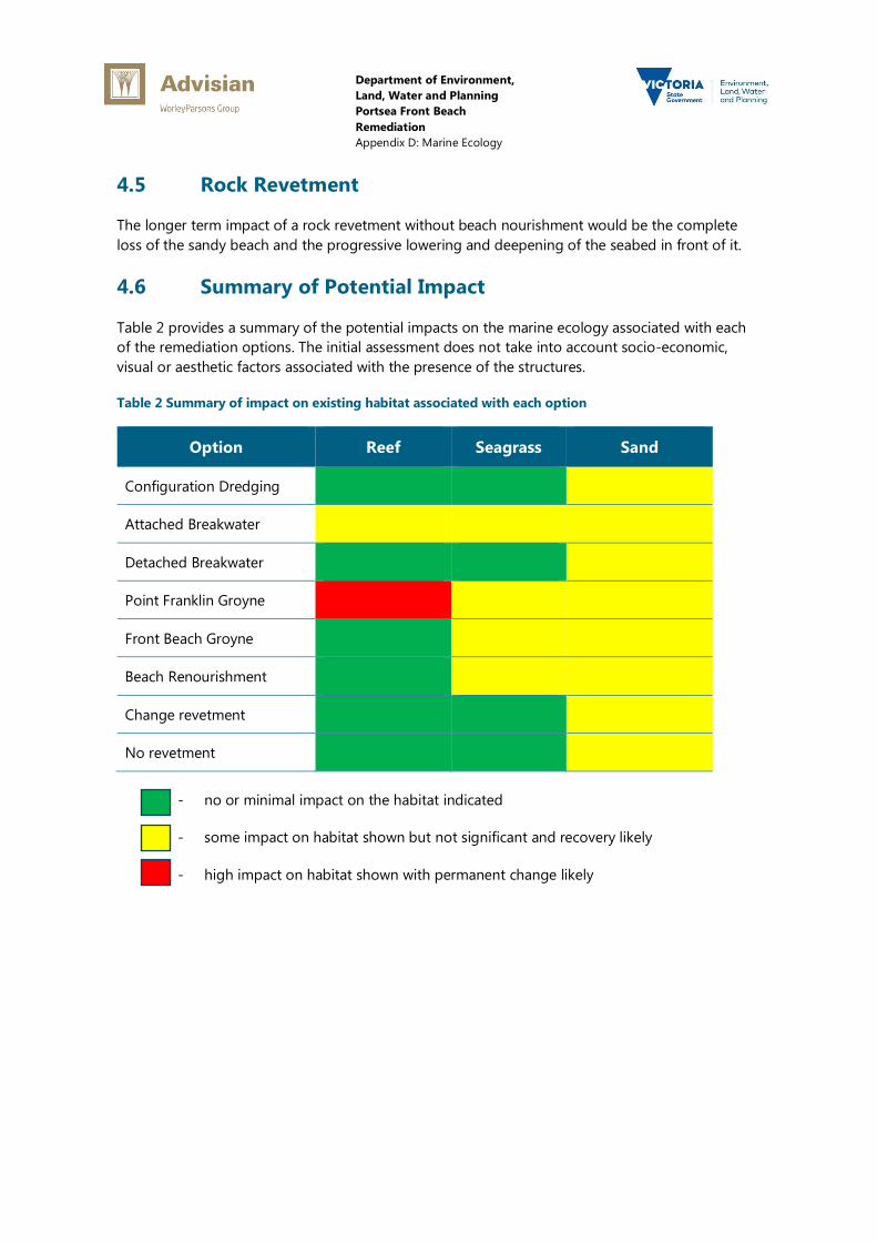
Table 2 provides a summary of the potential impacts on the marine ecology associated with each
of the remediation options. The initial assessment does not take into account socio-economic,
visual or aesthetic factors associated with the presence of the structures.
Table 2 Summary of impact on existing habitat associated with each option
Option Reef Seagrass Sand
Configuration Dredging
Attached Breakwater
Detached Breakwater
Point Franklin Groyne
Front Beach Groyne
Beach Renourishment
Change revetment
No revetment
- no or minimal impact on the habitat indicated
- some impact on habitat shown but not significant and recovery likely
- high impact on habitat shown with permanent change likely
Department of Environment,
Land, Water and Planning
Portsea Front Beach
Remediation
Appendix D: Marine Ecology
5 Regulatory Requirements
A range of approvals will be required depending on the option selected.
5.1 Coastal Management Act Consent
All options will require assessment (as a minimum) under the Coastal Management Act.
All use or development of coastal Crown land by any party, including committees of management
and municipal councils, requires consent under the Coastal Management Act 1995. Coastal Crown
land is generally all Crown land within 200 m of the high tide mark and the seabed of Victorian
coastal waters.
The consent process applies to all coastal Crown land, regardless of status in a planning scheme
and ensures that the Crown has the opportunity to represent the broader public interest in matters
affecting the coast and seabed.
5.1.1 Preliminary Assessment
Dredging, beach renourishment, construction of groynes and breakwaters will require CMA Act
consent.
5.1.2 Process and Timeframe
Once a Consent form is accepted as valid, the Minister (or delegate) must make a decision within
28 days. DEPI may request additional information in writing depending on the nature of the works
and the information provided.
Under section 40(3) of the Coastal Management Act 1995, if the Minister does not make a decision
within 28 days, the application is deemed to be refused.
Where the proposal includes dredging of coastal Crown land, as will be required for a range of
options that require a source of sand, the application must include a completed application form
that is specific to dredging.
5.1.3 Supporting Technical Studies Required
A range of supporting technical studies is likely to be required to support the CMA Consent. These
would include but not be limited to:
sediment characterisation study to demonstrate the sediments are clean (free of toxicants)
sediment characterisation study to demonstrate that sand is of suitable grade for placement
on the beach.
Department of Environment,
Land, Water and Planning
Portsea Front Beach
Remediation
Appendix D: Marine Ecology
5.2 Environment Effects Act 1978
The need for an EES referral is triggered by criteria set out in ministerial guidelines. The referral
criteria are focused on the potential for a significant effect on the environment.
The Minister, when deciding whether an EES is required, will consider the following:
The potential for significant adverse effects on individual environmental assets, taking into
account the magnitude, geographic extent and duration of change in the values of each asset.
The likelihood of effective avoidance and mitigation measures.
The likelihood of adverse effects and associated uncertainty of available predictions.
The likelihood that available environmental standards provide a sufficient basis for managing
key issues.
The likelihood that the project is not consistent with applicable policy.
The range and complexity of potential adverse effects.
The availability of project alternatives that may warrant investigation to assess opportunities to
avoid or minimise adverse environmental effects.
Other available assessment processes that may be suitable to address potential environmental
effects.
The likely level of public interest in a proposed project.
5.2.1 Preliminary Assessment
An assessment of the various options was undertaken, however this is only preliminary in nature
and it is likely that ongoing consultation with the public and the Department will determine the
level of assessment that will eventually be required:
Options requiring construction of groynes and beach renourishment are unlikely to require
assessment under the EES Act.
Options requiring construction of a detached breakwater and configuration dredging may
require assessment under the EES Act although this could be avoided if enough supporting
technical information can be provided with the referral to demonstrate that any impact is
manageable. There are existing precedents elsewhere in Port Phillip Bay where similar
structures and projects have not required an EES.
The attached breakwater option which has the largest footprint of all the options considered is
likely to require an assessment under the EES Act.
5.2.2 Process and Timeframe
All options will require a referral which would recommend to the Minister whether an EES is
required or not. The EES process can be broken down into several discrete steps:

Department of Environment,
Land, Water and Planning
Portsea Front Beach
Remediation
Appendix D: Marine Ecology
Referral
Project referred to Minister for
Planning
A project is referred by a proponent or decision-maker in accordance with
the referral criteria.
Decision
Minister's decision on the
need for an EES
The Minister will make one of three decisions, normally within 20 business
days of accepting a referral:
Yes, EES is required
Approval decisions are put on hold until the EES process is completed.
No, EES is not required
Decision-makers can proceed with their approval process.
No, EES is not required but conditions must be met
Conditions might relate to the location or dimensions of the project or
mitigation measures, or alternately requirements for further studies or
consultation.
Scoping
Scoping requirements for EES
studies and report set by
Minister
The matters to be investigated and documented in an EES are set out in the
'scoping requirements' issued by the Minister.
Draft scoping requirements are released for public comment for at least 15
business days before the final scoping requirements are published.
Preparing the EES
Proponent prepares the EES
The proponent must prepare EES, as well as a study program and
consultation plan consistent with the scoping requirements.
A Technical Reference Group, with members from government agencies,
local government and statutory authorities, is appointed to provide advice
to the proponent and the Department during the preparation of the EES.
Public review
Exhibition of EES and
lodgement of submissions
When the Minister is satisfied that the EES is suitable, it is released for public
comment for between 20 and 30 business days. During this time, the public
can make written submissions.
The Minister may appoint an inquiry to evaluate the effects of the project,
having regard to the EES studies and public submissions.
Making an assessment
Minister's Assessment of
environmental effects
As the final stage of the EES process, the Minister prepares an Assessment
considering all relevant information. The Minister's Assessment is normally
provided within 25 business days of the inquiry report being finalised.
The Assessment includes findings on the environmental effects, and may
conclude that the project:
Will have an acceptable level of environmental effects; or

Department of Environment,
Land, Water and Planning
Portsea Front Beach
Remediation
Appendix D: Marine Ecology
Will not have an acceptable level of environmental effects; or
Would need major modifications and/or further investigations to
establish that acceptable outcomes would be achieved.
Informing decisions
Decision-makers consider the
Assessment
Decision-makers must consider the Minister's Assessment in deciding
whether to approve a project under Victorian law or to authorise public
works. While the recommendations in the Assessment are authoritative,
they are not usually binding on decision-makers.
5.3 Other Considerations
The Sea Dumping Act does not apply where dumping is to occur entirely in Internal Waters
such as Port Phillip Bay so no sea dumping permit will be required for dredging and sand
renourishment activities. However, the suitability of sediment will need to be characterised in
accordance with the NAGD (Commonwealth of Australia, 2009).
An EPBC referral is unlikely to be required however under Part 3 of the EPBC Act, there are nine
matters of national environmental significance of which two are potentially relevant to this Project
including:
Nationally threatened species and ecological communities (Section 18, 18A, 19) and
Migratory species (Section 20, 20A, 20B)
These two matters would require additional assessment to confirm the requirement.
Department of Environment,
Land, Water and Planning
Portsea Front Beach
Remediation
Appendix D: Marine Ecology
6 Conclusions
Of all the options assessed those which require the construction or placement of solid structures
on the seabed will have the greatest potential ecological impact.
Although the configuration dredging option does require the dredging and excavation of a
relatively large area of seabed, the resultant area will be available for recolonization by equivalent
benthic species, hence the net environmental impact is considered low.
The T groyne attached breakwater option will have a much greater impact than the detached
breakwater option by virtue of the size of the construction footprint and that it intersects a range
of inshore and offshore habitat types.
Construction of the Point Franklin groyne option over an area of natural reef is also likely to have a
greater ecological impact than the Portsea front beach groyne option which mainly intersects sand.
The reef at Point Franklin has lower biodiversity than comparable reefs elsewhere in southern Port
Phillip Bay. However, it is a popular ecological site due its accessibility. Construction of a rock
groyne using rock armour at the site will partially offset the loss of habitat. However, at least half of
the effective area available for recolonization will be lost due to the build-up of sand on the beach
side of the groyne.
All options will require assessment under the Coastal Management Act and CMA Consent will be
required for the project to proceed. An EES is unlikely to be required for most of the options
considered in this report. However, the decision will be contingent on likelihood of adverse effects
and associated uncertainty of available predictions associated with the option and the level of
public interest.

Department of Environment,
Land, Water and Planning
Portsea Front Beach
Remediation
Long Term Options Assessment
Advisian 53
THIS PAGE LEFT BLANK