11 th annual z/i camera conference february 2007 post hurricane katrina & rita 6-inch dmc...
TRANSCRIPT

11th Annual Z/I Camera Conference
February 2007
Post Hurricane Katrina & Rita 6-inch DMC Digital Orthophotography
2
3001 Corporate Profile
• Founded in 1965• Turnkey Geospatial Solutions • Geospatial Data Acquisition
•1st DMC Owner in North America•12 Aircraft and 11 cameras and sensors
• ISO 9001 Registered• Core Businesses
•Federal Services•Intel-Defense Solutions •Civil Works •LandAir (airborne flight ops)

3
3001 Core Competencies
• Aerial Photography• GIS Services• Imagery Analysis• LiDAR• Mapping• Surveying• Consulting Services

4
Project Description
• CLIENT: New Orleans Regional Planning Commission (NORPC) and Partner Agencies.
•STUDY AREA: 3,000 square miles in pocket areas across southern Louisiana for regions affected by Katrina and Rita.
•NEED: Post-Katrina and Rita digital orthophotography for urbanized areas and levee locations affected by the hurricanes.

5
Project Description
• DATA ACQUISITION:•Spring 2006 flights•4,600’ AGL•60% forward lap, 30% sidelap•18,950 images flown
•DATA PROCESSING: •2 shifts for A/T and ortho generation•Lots of manual edits in PhotoShop for sun glare
•PRODUCTS:•DMC 6-inch orthophotos•Ground control Reports•Aerotriangulation Reports•Ortho-rectified Mosaics

6
Project Description
• PRODUCT APPLICATIONS:•Storm-damage environmental assessment•Levee mapping and analysis•Debris mapping and analysis (above-water and near-shore) •Shoreline change detection•General emergency response and preparedness for future events

7
The Z/I DMC Was Selected Because:
• Design Format – 8 CCD Frame Array (~14,000 X 7,000 Pixel Frame)• Pixel Resolution – 1.5” To 2M Pixel Size• Radiometric Resolution – 12-bit Native Resolution• Multispectral Bands – Panchromatic, RGB, And Near IR With
Overlapping Spectral Response• Applications – Base Mapping, Engineering Studies, Photogrammetry,
Remote Sensing

NORPC & Partners DMC Mission
NORPC & Partners DMC Mission
Green, Yellow, and Pink Boxes are
project study areas

9
Detail of the New Orleans Project Area
• Design Format – 8 CCD Frame Array (~14,000 X 7,000 Pixel Frame)• Pixel Resolution – 1.5” To 2M Pixel Size
NOTE: Project areas were separated based on funding & client partners
10
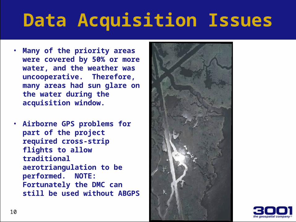
Data Acquisition Issues
• Many of the priority areas were covered by 50% or more water, and the weather was uncooperative. Therefore, many areas had sun glare on the water during the acquisition window.
• Airborne GPS problems for part of the project required cross-strip flights to allow traditional aerotriangulation to be performed. NOTE: Fortunately the DMC can still be used without ABGPS

11
Sun Glare on Water for Raw Mosaics

12
Final Mosaic with Sun Glare Minimized

13
City of New Orleans Orthos

14
NORPC DMC Orthos (Sample 1)
New Orleans, LA. Inner Harbor
Navigation Canal
Note the Blue Roofs

15
Claiborne AveBridge to
Chalmette (Sample 2)

16
Levee Repairs (Sample 3)

17
Flooded & Destroyed Homes (sample 4)

18
Conclusions
• The Z/I DMC is a Very Versatile Digital Camera System.• Multiple Products and Applications Can Be Easily Delivered.• Ability to work without ABGPS and IMU can make the difference between success
and failure.• This project is helping Louisiana recover and prepare.• The clients are very happy with the final products.
THANK YOU
Jay Arnold Jeff Lower
256-327-9377 256-327-9376
