11 road drainage and the water environment 11: road drainage and the water environment page 11-1 11...
TRANSCRIPT
A9 Dualling – Dalwhinnie to Crubenmore DMRB Stage 3 Environmental Impact Assessment
Chapter 11: Road Drainage and the Water Environment Page 11-1
11 Road Drainage and the Water Environment
11.1 Introduction
11.1.1 This chapter describes the Environmental Impact Assessment (EIA) of potential impacts on the natural water environment associated with the ‘Design Manual for Roads and Bridges’ (DMRB) Stage 3 Proposed Scheme for Project 8 – Dalwhinnie to Crubenmore (Central Section) of the A9 Dualling Programme. The Proposed Scheme to be assessed is described in Chapter 5.
11.1.2 This chapter presents the EIA approach, describing baseline conditions, design development and embedded mitigation. Key issues for assessment and potential impacts are identified, mitigation to reduce or negate any potential impacts is proposed, and any remaining ‘residual’ impacts highlighted.
11.1.3 The information and findings of this chapter will also support future statutory approvals such as licensing of works potentially affecting the natural water environment under the Controlled Activity Regulations (CAR) and provide input to Habitats Regulations Appraisal (HRA).
11.1.4 The approach described follows guidance set out in DMRB (2009), Volume 11: Environmental Assessment, Section 3, Part 10, HD45/09: ‘Road Drainage and the Water Environment’ (DMRB HD45/09). The assessment has a particular requirement to assess significant environmental impacts of the project as defined in DMRB (1993), Volume 5, Section 1, Part 2 TD37/93: ‘Scheme Assessment Reporting’ (DMRB TD37/93). This involves a ‘detailed’ assessment of the potential environmental impacts with consideration given to the following attributes of the water environment:
• Importance of the surface water and groundwater environment
• Proposed Scheme construction and operation-related pollution
• Hydrology and flood risk
• Changes to hydromorphology
• Surface water quality and quantity
• Groundwater quality
11.1.5 In the context of this chapter ‘surface water’ means all standing or flowing water on the surface of the land (e.g. rivers, lochs, canals, reservoirs, ponds and wetlands). ‘Wetland’ means an area of ground the ecological, chemical and hydrological characteristics of which are attributable to frequent inundation or saturation by water and which is directly dependent, with regard to its water needs, on a body of groundwater or a body of surface water.
11.1.6 The water environment is intrinsically linked to ecological receptors. Where relevant, references to Chapter 12 have been made in this chapter and related appendices. Similarly, this chapter considers potential impacts to groundwater quality (associated with road runoff and spillage). Other potential impacts to groundwater resulting from disturbances to groundwater flow including potential interference with Private Water Supplies (PWS) are discussed and assessed in Chapter 10.
11.1.7 Supporting assessments also relating to the water environment e.g. land use (waterway restoration projects, loss of watering points for livestock) and landscape considerations (sensitive naturalistic design of watercourses) are provided in Chapter 8 and Chapter 13, respectively.
A9 Dualling – Dalwhinnie to Crubenmore DMRB Stage 3 Environmental Impact Assessment
Chapter 11: Road Drainage and the Water Environment Page 11-2
11.2 Approach and Methods
11.2.1 This section describes the methods used to assess potential impacts of the Proposed Scheme on the natural water environment, categorised under the following headings: Surface and Groundwater Quality, Hydrology and Flood Risk, and Hydromorphology.
11.2.2 Sources of relevant guidance, the study area, baseline data sources, and procedures for assigning qualitative and quantitative values for the potentially affected water features are described in this section. Limitations of the assessments are also discussed. More detailed methodological information for each of the supporting assessments is provided in separate appendices.
11.2.3 The assessment has taken into account relevant legislation and regulations including:
• Water Framework Directive (WFD) (2000/60/EC)
• Water Environment Water Services (WEWS) Act 2003
• The Water Environment (Controlled activities) (Scotland) Regulations 2011 (as amended) (CAR)
• EU Floods Directive (2007/60/EC)
• Flood Risk Management (Scotland) Act 2009
• The Climate Change (Scotland) Act 2009
• Water Framework Directive (WFD) policy guidance ‘The Future for Scotland’s Waters, Guiding Principles on the Technical Requirements of the Water Framework Directive’ (SEPA, 2002)
• European Union (EU) Drinking Water Directive (98/83/EC)
• The Environment Act 1995
• Surface Waters (Fishlife) (Classification) (Scotland) (Amendment) Regulations, 2003
• Control of Pollution Act 1974 (CoPA)
• Environmental Protection Act 1990
• Environmental Liability (Scotland) Regulations 2009
• The Water Supply (Water Quality) (Scotland) Regulations, 2001
• The Public Water Supplies (Scotland) Regulations 2014
• The Private Water Supplies (Scotland) Regulations 2006
• The Water Environment (Oil Storage) (Scotland) Regulations 2006
• Pollution Prevention and Control (Scotland) Regulations 2012 (PPC 2012)
11.2.4 Further explanation and relevance of national/ local planning policies affecting hydrology/ drainage is provided in Chapter 19.
Scope and guidance
11.2.5 In addition to the guidance in DMRB HD45/09, various reference documents have been used in the assessment. A list of the principal reference documents is provided under the following headings:

A9 Dualling – Dalwhinnie to Crubenmore DMRB Stage 3 Environmental Impact Assessment
Chapter 11: Road Drainage and the Water Environment Page 11-2
Pollution prevention and flood mitigation measures, pertinent to surface water and groundwater
• DMRB, 2006, Volume 4: Geotechnics and Drainage, Section 2: Drainage, Part 1, HA103/06: ‘Vegetated Drainage Systems for Highway Runoff’, and Part 3, HD33/16: ‘Design of highway drainage systems’
• ‘Sustainable Drainage Systems, Hydraulic, Structural and Water Quality Advice’, CIRIA C609, 2004
• ‘The Sustainable Drainage Systems (SuDS) Manual’, Construction Industry Research and Information Association (CIRIA) C753, 2015 and ‘SuDS for Roads’, WSP, 2009
• ‘Scottish Planning Policy’, 2014 and ‘Planning Advice Note 61: Planning & SuDS’
• ‘Control of Pollution from Highway Drainage Discharges’, CIRIA C142, 1994
• ‘Regulatory Method (WAT-RM-08), ‘Sustainable Urban Drainage Systems (SUDS or SUD Systems)’, SEPA, v6.1, 2017 and Supporting Guidance (WAT-SG-53) ‘Environmental Standards for Discharges to Surface Waters’ v6, SEPA, 2015
• ‘User Guide: Groundwater Vulnerability (Scotland) Geographical Information System (GIS) Dataset’, Version 2 (OR/15/002), British Geological Survey, 2015
• ‘Groundwater Protection Policy for Scotland Version 3, Environmental Policy Number 19’, SEPA, 2009
• ‘Technical Flood Risk Guidance for Stakeholders’, SEPA, 2015
Watercourse diversion and culvert designs
• DMRB, 2004, Volume 4: Geotechnics and Drainage, Section 2: Drainage, Part 7, HA107/04: ‘Design of Outfall and Culvert Details’
• ‘Manual of River Restoration Techniques’, River Restoration Centre (RRC), 2002, River Diversions A Design Guide, HR Wallingford, 2001
• ‘River Diversions A Design Guide’, HR Wallingford, 2001
• ‘Culvert Design and Operation Guide’, CIRIA C689, 2010
• ‘Engineering in the Water Environment: Good Practice Guide, River Crossings’ Second Edition (WAT-SG-25), SEPA 2010
• ‘River Crossings and Migratory Fish’, Design Guidance, Scottish Executive
Construction phase activities
• WAT-SG-29: ‘Temporary Construction Methods’, Good Practice Guide, SEPA, 2009
• WAT-SG-31: ‘Special Requirements for Civil Engineering Contracts for the Prevention of Pollution’, SEPA, 2006 and WAT-SG-32: ‘Guidance on the Special Requirements for Civil Engineering Contracts’, SEPA, 2006
• ‘Control of Water Pollution from Linear Construction Projects’, Technical Guidance CIRIA (C648), 2006

A9 Dualling – Dalwhinnie to Crubenmore DMRB Stage 3 Environmental Impact Assessment
Chapter 11: Road Drainage and the Water Environment Page 11-3
Study area
11.2.6 The Proposed Scheme assessed in this report runs parallel to the east of the River Truim. It is approximately 11km in length beginning at the northern edge of the Drumochter Hills at chainage (ch.) 20,000, passing the village of Dalwhinnie, travelling northwards to Crubenmore at ch. 31,050, as shown in Drawings 5.1 to 5.9 of Volume 3 of this report.
11.2.7 A 1km-wide corridor, notionally 500m to the east and west of the existing A9, was initially defined as the study area for assessment of potential Road Drainage and Water Environment impacts. As the River Truim acts as a hydrological barrier it is unlikely the Proposed Scheme will have an impact on water features beyond the opposite bank (i.e. left bank looking downstream) from the A9. Therefore, the study area for this assessment has been refined and is now defined by:
• Hydrological features shown on a 1:10,000 Ordnance Survey (OS) map have been delineated by a 500m offset on the east side of the existing A9 corridor and the left bank (looking downstream) of the River Truim (where the distance between the road and the river is less than 500m). The notional distance has been extended in cases where there are significant hydrological features that may potentially be affected by the Proposed Scheme. This has been defined as the ‘DMRB3 Wider Study Area’
• An overview of the permanent and temporary works assessment boundaries applied in the assessment of the Proposed Scheme is provided in Drawings 5.1 to 5.9 (Volume 3). In those, a red line boundary delineates the proposed DMRB Stage 3 infrastructure design, including all mainline, junction and drainage infrastructure, and watercourse diversions. This red line represents the ‘Permanent Works’ assessment boundary and includes the 5m offset from the design extents. Outwith the red line, a green line is shown in a number of areas; these have been considered as areas required to enable construction activities and are considered as the ‘Temporary Works’ assessment boundary. For the purposes of this chapter, this has been defined as the ‘DMRB Stage 3 Detailed Study Area’
11.2.8 The study areas are shown in the Water Features Plans, Volume 3, Drawings 11.1 to 11.9 (Volume 3) of this report.
11.2.9 For hydrological analysis of watercourses crossed by the Scheme, full catchment areas were considered beyond the outlined study area where applicable. These are shown in the Surface Water Catchments, Drawing 11.10 (Volume 3).
11.2.10 There are a number of spatial constraints identified within the study area, including the River Truim, the Highland Main Line (HML) railway, and a section of the Beauly to Denny Power Line (BDL). Significant environmental constraints include internationally and nationally designated ecological sites, specifically the River Spey Special Area of Conservation (SAC) (which includes the River Truim), and the Drumochter Hills SAC, Special Protection Area (SPA) and Site of Special Scientific Interest (SSSI). These are discussed in greater detail in Chapter 12.

A9 Dualling – Dalwhinnie to Crubenmore DMRB Stage 3 Environmental Impact Assessment
Chapter 11: Road Drainage and the Water Environment Page 11-4
Baseline data sources
Desk-based Study
11.2.11 Principal data sources used to collate baseline information for water features within the study area include:
• Transport Scotland A9 Dualling: ‘Strategic Environmental Assessment’ (SEA) – Environmental Report (2013)
• Transport Scotland A9 SEA Report Addendum Appendix F: ‘Strategic Flood Risk Assessment’ (SFRA) (2013)
• Ordnance Survey (OS) 1:50,000 raster and 1:10,000 vector mapping • SEPA online Flood Maps (2014) • SEPA’s River Basin Management Plans (RBMP) • SEPA Sensitive Receptors GIS dataset • Flood Estimation Handbook (FEH) CD-ROM v.3 (2009) • Transport Scotland (2014) ‘DMRB Stage 1 Assessment A9 Dualling: Preliminary Engineering
Support’ (PES) Services • British Geological Survey (BGS) GIS datasets of groundwater vulnerability classes and survey
data (1:50k maps) • Historical mapping • Scottish Natural Heritage (SNH) GIS datasets of designated nature conservation areas,
including SSSIs and SACs • SNH, Royal Society for the Protection of Birds (RSPB) and Spey Fisheries Board (SFB)
information on local habitats and features • Scottish and Southern Energy (SSE) aqueduct as-built drawings • SEPA flow gauge data • SEPA online interactive Drinking Water Protection Areas (DWPA) mapping • SEPA water chemistry data
11.2.12 As the River Truim is a tributary to the River Spey, an appreciation of the Spey, and wider Spey catchment, was essential in informing impact assessments on the River Truim and its tributaries. A range of published reports informed the assessment of baseline conditions (mainly relating to hydromorphology and flood risk), with key documents including:
• Cuthbertson and Partners – ‘Flooding in Badenoch and Strathspey Flood Study for The Highland Regional Council’ (1990)
• EnviroCentre Report No: 3329 – ‘River Spey Abstractions’ to the Spey Fishery Board (2008) • Gemmell, S. L. G., Hansom, J. D., Hoey, T. B. – ‘The geomorphology, conservation and
management of the River Spey and Spey Bay SSSIs, Moray’, Scottish Natural Heritage Research and Monitoring Report No. 57 (2001)
• Gilvear, D. J. – ‘Patterns of channel adjustment to impoundment of the upper River Spey, Scotland between 1942 and 2000’ (2004)
• Werritty, A., Ferguson, R. I. – Pattern changes in a Scottish braided river over 1, 30, and 200 years (1980)

A9 Dualling – Dalwhinnie to Crubenmore DMRB Stage 3 Environmental Impact Assessment
Chapter 11: Road Drainage and the Water Environment Page 11-5
Site Walkovers and Surveys
11.2.13 A photogrammetry survey carried out by Blom (2014) for Transport Scotland enabled identification of water features and crossing locations. This information was supplemented by site walkovers undertaken between March and October 2015 to refine information on culverts crossing the existing A9, watercourses, and geomorphic characteristics. Location-specific watercourse channel and hydraulic structure surveys were undertaken during May and June 2016.
Ground Investigation
11.2.14 Ground investigations (GI) have been undertaken for the Proposed Scheme, as described in Chapter 10. Relevant information from the GI regarding water table depth, groundwater quality, and superficial geology was used to inform the water environment assessment. A programme of additional ground and surface water quality monitoring is currently being undertaken.
Water Features Survey
11.2.15 The baseline assessment of water features was informed by a Water Features Survey (identifying key water features that may be affected by the Proposed Scheme via desktop studies and site walkovers), and a review of information obtained from sources described above.
11.2.16 Relevant baseline information on individual watercourses, drains, ponds, wetlands, springs, abstractions, discharges, and built structures (i.e. dams, reservoirs, and aqueduct) has been recorded in a Water Features Schedule in Appendix 11.1, contained in Volume 2 and accompanying Water Features Plans included in Drawings 11.1 to 11.9, (Volume 3). This information and the three environmental parameters of Water Quality, Hydromorphology, and Hydrology and Flood Risk are used to determine the sensitivity values assigned to each watercourse within the study area which may be affected by the Proposed Scheme.
11.2.17 For the purposes of assessment, watercourses within the study area have been identified using OS mapping and classified as either ‘Major Watercourses’ (MW) or ‘Minor Watercourses’ (W):
• Major Watercourse – shown on 1:50,000 scale OS maps
• Minor Watercourse – shown on 1:10,000 scale OS maps or identified by the Blom survey and via site walkovers
11.2.18 Minor watercourses also include field drains and existing road drains which have been identified from topographical surveys and review of Transport Scotland records. All watercourses that cross the existing A9 (i.e. via bridges and culverts) have been an assigned a ‘Hydro ID’ as shown on Drawings 11.1 to 11.9 (Volume 3). Those that do not cross the A9, but are still within the study area, are assigned a ‘Major’ (MW) or ‘Minor’ (W) water feature reference number only.
11.2.19 The water features schedule also identifies some private water supply abstractions and several private sewage discharges. Further detail on these is provided in Chapter 10.
Scoping out
11.2.20 An initial screening assessment was carried out to determine which of the waterbodies identified by the Blom survey were unlikely to be impacted by the Proposed Scheme. This reduced the number from over 300 to approximately 200 within the study area.
11.2.21 There are also numerous minor field or road drainage ditches which run parallel to, but do not cross, the existing A9 road corridor. These are likely to be affected by the widened road corridor.

A9 Dualling – Dalwhinnie to Crubenmore DMRB Stage 3 Environmental Impact Assessment
Chapter 11: Road Drainage and the Water Environment Page 11-6
As they are man-made and do not exhibit significant hydrological/ ecological or other attributes (and will be replaced by a new drainage layout), they are not assessed further, i.e. are not subject to a pre-and post-mitigation assessment.
Procedure for Assessing Impacts
11.2.22 DMRB HD45/09 sets out a framework through which the assessment considers the attributes of water features in the existing natural water environment, and the potential impacts of the Proposed Scheme on them, in terms of magnitude and significance. The significance of any potential impact is a product of the sensitivity of the water feature (based on its importance) and the magnitude of the impact being considered.
11.2.23 HD45/09 sets out the procedures for assessing four principal areas as follows:
• Effects of Routine Runoff on Surface Waters
• Effects of Routine Runoff on Groundwater
• Pollution Impacts from Accidental Spillages
• Assessing Flood Impacts
11.2.24 For the purposes of the assessment the spatial extent considered when assigning magnitude and significance of impact relies on professional judgement. Some of the potential impacts will be limited to the vicinity of works; for example, bank protection will affect a small percentage of a watercourse’s overall length. Others may have farther reaching effects, such as encroachment into the functional floodplain potentially affecting flood levels outwith the study area. These spatial factors are considered accordingly and reported where applicable. Cumulative impacts are considered separately in Chapter 20.
Water Quality
11.2.25 Potential water quality impacts have been assessed using the Highways Agency (now Highways England) Water Risk Assessment Tool (HAWRAT). HAWRAT is a Microsoft Excel tool designed to evaluate risks related to the intermittent nature of routine road runoff. It assesses the acute pollution impacts on aquatic ecology associated with soluble pollutants, and the chronic impacts associated with sediment-bound pollutants.
11.2.26 HAWRAT allows the user to assess the effect of potential impacts on water quality, as well as the effectiveness of any recommended mitigation measures, by predicting road runoff pollutant loading at each step of the assessment and comparing it against runoff specific thresholds (RSTs) (e.g. Environmental Quality Standards (EQSs)) based on annual average concentrations. The relevant EQSs for the protection of freshwater aquatic life have been derived from SEPA’s Supporting Guidance (WAT-SG-53). These are given as 1.0µg/l for copper and 11.9µg/l for zinc.
11.2.27 The DMRB method for assessing potential impacts of routine runoff to groundwater applies when there is direct discharge to groundwater; the methodology is based on a Source-Pathway-Receptor (S-P-R) protocol. Where all proposed road drainage outfalls discharge to surface water bodies (i.e. there are no direct discharges to groundwater), potential groundwater contamination is not generally assessed. However, DMRB HD33/16 recommends that where the treatment system is designed with an element of infiltration (e.g. SuDS basins/ dry ponds, swales and grassed channels), the risk to groundwater should be evaluated using the DMRB HD45/09 method.
A9 Dualling – Dalwhinnie to Crubenmore DMRB Stage 3 Environmental Impact Assessment
Chapter 11: Road Drainage and the Water Environment Page 11-7
11.2.28 In terms of accidental spillages, HAWRAT evaluates the risk of occurrence of an incident or event on the road network giving rise to toxic materials entering the water environment. It takes account of specific ‘higher risk’ features, such as slip roads and junctions, as well as traffic volumes using road length and the proportion of Heavy Goods Vehicles (HGVs) derived from traffic modelling. A more detailed description of the procedures for assessing water quality from HD45/09 is provided in the Water Quality Assessment in Appendix 11.2, (Volume 2).
Hydrology and Flood Risk
11.2.29 Hydrological and hydraulic modelling has been carried out to predict flood water levels, assess flood impacts, and provide an estimate of compensatory flood storage requirements. Where embankments were shown to encroach on existing watercourse extents, suggesting a loss of existing channel and/ or functional floodplain, proposed earthworks have been refined to avoid unnecessary loss of conveyance or flood storage capacity. The results of the hydraulic modelling also informed the recommended flooding-related mitigation measures (e.g. culvert upsizing).
11.2.30 Understanding of baseline flood conditions has been enhanced using information derived from the development of a 2D flood model for the River Truim with additional 1D elements incorporated into the 2D model. Development for DMRB Stage 3 included updated surveyed river cross-sections and structures. The approach adopted for DMRB Stage 3 has been reviewed and accepted as appropriate by SEPA. Further detail of modelled flood extents is shown on Drawings 11.11 to 11.20 (Volume 3) and the hydrological and hydraulic modelling approach is provided in the Flood Risk Assessment (FRA) within Appendix 11.3 (Volume 2).
Hydromorphology
11.2.31 DMRB contains no specific procedures for assessing hydromorphological impacts; however, related targets for restoring and improving the natural water environment are established via the Water Environment and Water Services (Scotland) Act 2003 (WEWS). Assessment of the baseline hydromorphological processes and associated impacts has, therefore, been carried out using procedures developed from the following key reference documents:
• ‘Assessing the Significance of Impacts – Social, Economic, Environmental - Supporting Guidance’ (WAT-SG-67) (SEPA), 2015
• ‘Review of Impact Assessment Tool and Post Project Monitoring Guideline, Report to SEPA’ by Haycocks Associates (WAT-SG-30), 2005
• ‘The Fluvial Design Guide’, Environment Agency (EA), 2009
• ‘Guidebook of Applied Fluvial Geomorphology’, Department of Environment Food and Rural Affairs Technical Report TD1914 (DEFRA/ EA), 2003
11.2.32 A Detailed Catchment Baseline Survey (DCBS), which included field-based river reconnaissance surveys, was carried out to enhance the desk-based studies. This established the current conditions of watercourses by assessing topography, hydrological regime, sediment processes and characteristics of the water environment. A more detailed description of the adopted procedures and methods is provided in the Hydromorphology Assessment within Appendix 11.4, (Volume 2).

A9 Dualling – Dalwhinnie to Crubenmore DMRB Stage 3 Environmental Impact Assessment
Chapter 11: Road Drainage and the Water Environment Page 11-8
Consultation
11.2.33 Further input has been provided throughout the design process via consultation forums and an Environmental Steering Group (ESG) (which includes members of SEPA, SNH, The Highland Council (THC), Cairngorms National Park Authority (CNPA), and Historic Environment Scotland (HES)). The ESG helped develop a range of Strategic Environmental Design Principles that are consistent between projects across the A9 Dualling programme. Details of the Principles relevant to the water environment are provided in Table 2.1.6 of Appendix 2.1, (Volume 2).
11.2.34 Further consultation with additional relevant stakeholders (non-ESG members) including Spey Fisheries Board (SFB) and local resident groups has also been undertaken. Details of consultation processes are provided in Chapter 7.
Procedure for selection and impact evaluation of replacement watercourse crossings
11.2.35 All watercourse crossings are designed and assessed individually as well as cumulatively to ensure any potentially adverse impacts are avoided and appropriately mitigated.
11.2.36 Figure 11-1 outlines the decision-making process followed when considering the replacement or extension of existing crossings. The underlying aim has been, wherever possible, to maintain existing conveyance capacity to minimise loss of flood water storage, whilst considering potential for improvement at locations where existing infrastructure is constructed on the functional floodplain.
11.2.37 New crossings are designed to convey peak flows for a 200 year flood event. In recognition of predicted climate change effects, 20% is added to peak design flows. A freeboard allowance has also been included when assessing potential flood risk to sensitive receptors to cater for other hydrological and modelling uncertainties, and sufficient clearance has been provided between the design water level and the underside of structures to allow free passage of floating debris.
11.2.38 Where possible, opportunities have been taken to remove existing ecological, morphological, and hydrology/ flood risk pressures. Where no such design driver was identified at existing crossings, and a larger culvert was not required for other reasons such as operational access, consideration was given to maintaining existing conveyance capacity and upstream flood storage. This has limited the volume of compensatory flood storage required to offset loss of functional floodplain.

A9 Dualling – Dalwhinnie to Crubenmore DMRB Stage 3 Environmental Impact Assessment
Chapter 11: Road Drainage and the Water Environment Page 11-9
Figure 11- 1: Flow chart of process for selection and impact evaluation of replacement watercourse
crossings

A9 Dualling – Dalwhinnie to Crubenmore DMRB Stage 3 Environmental Impact Assessment
Chapter 11: Road Drainage and the Water Environment Page 11-10
Assigning sensitivity values to water feature attributes
11.2.39 In accordance with the HD45/09 water impact assessment, sensitivity values must be assigned to potentially affected water features and scheme-associated impacts.
11.2.40 Values for sensitivity are measured on a four point scale from ‘Low’ to ‘Very High’. Where more than one value is assigned to a single water feature reflecting different attribute sensitivities (i.e. water quality, hydrology and flood risk, hydromorphology), the corresponding value is used to determine the resulting significance of impact on that attribute.
11.2.41 A summary of the typical criteria/ indicator(s) of value considered when assigning sensitivity to affected water features is given in Table 11-1. Magnitudes of potential impacts to water features are outlined in Table 11-2 and the resulting significance of impact is provided in Table 11-3. A comprehensive list of sensitivities assigned to those water features subject to the Potential Impacts assessment is provided as part of the Water Features Schedule of Appendix 11.1, (Volume 2). Tables detailing the impact magnitude and significance values for the affected water features are provided in the relevant Appendices (Appendices 11.2 to 11.4, Volume 2).
Table 11-1 Water Feature Sensitivity
Sensitivity Typical Criteria/ Indicator of Value
Very High Water quality Surface Water
− Water Quality: ‘High’ overall Water Framework Directive (WFD) water quality status. None or a negligible number of anthropogenic pressures and/or pollutant sources affecting the water feature WFD status, and/or potable water supply serving >10 properties in remote areas where there is no access to alternative supplies.
− Biodiversity: ‘High’ overall WFD ecology status or for non-classified features, ‘High’ ecosystem quality, based on site observations and professional judgement. Presence of aquatic species and/or habitats identified as important at an international scale. Protected/ designated site under EC or UK habitat legislation (e.g. Special Area of Conservation (SAC), Special Protection Area (SPA), Ramsar site), and/or no existing pressures to biodiversity.
− Dilution and Removal of Waste Products: A high number of licenced discharges/ high daily volume of discharges to or within 50m of water feature (with potential hydraulic connectivity to the water feature) under CAR relative to flow
Groundwater An aquifer constituting a valuable resource because of its high quality and/or or extensive exploitation for public, private domestic (i.e. serving >10 properties) or agricultural/industrial use and/or groundwater is classified as having very high groundwater vulnerability (BGS Vulnerability Class 5).
Hydrology and Flood Risk Hydrologic importance to internationally designated sensitive ecosystems and/or critical social and economic uses (e.g. water supply, abstraction, recreation, amenity). Water feature with direct flood risk to > 100 residential properties or critical infrastructure (e.g. trunk road or mainline railway, hospitals, schools, safe shelters) in a 1 in 200-year event (0.5% AEP).

A9 Dualling – Dalwhinnie to Crubenmore DMRB Stage 3 Environmental Impact Assessment
Chapter 11: Road Drainage and the Water Environment Page 11-11
Sensitivity Typical Criteria/ Indicator of Value
Hydromorphology Sediment Regime
− Water feature sediment regime provides a diverse mosaic of habitat types suitable for species sensitive to changes in sediment concentration and turbidity, such as migratory salmon, freshwater pearl mussels. Water feature appears in complete equilibrium with natural erosion and deposition occurring. The water feature has sediment processes reflecting the nature of the catchment and fluvial system.
Channel Morphology − Water feature includes varied morphological features (e.g. pools, riffles, bars, natural bank
profiles) with no sign of channel modification. Natural Fluvial Processes
− Water feature displays natural fluvial processes and natural flow regime, which would be highly vulnerable to change as a result of modification.
High
Water Quality Surface Water
− Water Quality: Good’ overall WFD water quality status. A small number of anthropogenic pressures and/or pollutant sources that do not significantly affect the water feature WFD status and/or potable water supplies serving < 10 properties in remote areas where there is no access to alternative supplies and/ or use of water for extensive agricultural purposes
− Biodiversity - ‘Good’ overall WFD ecology status or for non-classified features, ‘Good’ ecosystem quality, based on site observations and professional judgement. Presence of aquatic species and/or habitats identified as important at a national scale. Protected/designated site under EC or UK legislation (SAC, SPA, Ramsar, SPA) and few existing pressures to biodiversity.
− Dilution and Removal of Waste Products: Some existing licenced discharges/ moderate daily volume of discharges to or within 50m of water feature under CAR relative to flow
Groundwater An aquifer of limited value either because of quality impairment or because exploitation is not extensive (i.e. private domestic and/ or agricultural supply serving < 10 properties) and/or groundwater is classified to have high vulnerability (BGS vulnerability class 4).
Hydrology and Flood Risk: Hydrologic importance to nationally designated ecosystems and/or locally important social and economic uses (e.g. water supply, abstraction recreations, and amenity). Water feature with direct flood risk to 1 -100 residential properties, > 10 industrial premises, and/or other land use of high value or indirect flood risk to critical infrastructure in a 1 in 200-year event (0.5% AEP).
Hydromorphology Sediment Regime:
− Water feature sediment regime provides habitats suitable for species sensitive to changes in sediment concentration and turbidity, such as migratory salmon, freshwater pearl mussels. Water feature appears largely in natural equilibrium with some localised accelerated erosion and/or deposition caused by land use and/or modifications. Primarily the sediment regime reflects the nature of the natural catchment and fluvial system.
Channel Morphology: − Water feature exhibiting a natural range of morphological features (e.g. pools, riffles, bars,
varied natural river bank profiles), with limited signs of artificial modifications or morphological pressures
Natural Fluvial Processes: − Predominantly natural water feature with a diverse range of fluvial processes that is highly
vulnerable to change as a result of modification

A9 Dualling – Dalwhinnie to Crubenmore DMRB Stage 3 Environmental Impact Assessment
Chapter 11: Road Drainage and the Water Environment Page 11-12
Sensitivity Typical Criteria/ Indicator of Value
Medium Water Quality Surface Water
− Water Quality: ‘Moderate’ overall WFD water quality status or not classified by SEPA. Likely to have deteriorated in water quality as a result of anthropogenic pressures and/or pollutant sources and/or potable water supplies, located within the vicinity of a mains water supply and/ or supplies used only for local agricultural purposes.
− Biodiversity: ‘Moderate’ overall WFD ecology status or for non-classified features, ‘Moderate’ ecosystem quality, based on site observations and professional judgement. Likely to exhibit a limited number of regional designated ecosystems and/or existing pressures which are likely to be affecting biodiversity.
− Dilution and Removal of Waste Products: Few existing licenced discharges/ low daily volume of discharges to or within 50m of water feature under CAR relative to flow
Groundwater Poor groundwater quality and/or low permeability make exploitation of groundwater unlikely and/or groundwater is classed as having moderate vulnerability (BGS vulnerability classes 2-3).
Hydrology and Flood Risk Some but limited hydrologic importance to sensitive ecosystems and/or social and economic uses Water feature with direct flood risk to agricultural or recreational land and/or affecting < 10 industrial premises and high value agriculture (e.g. arable pastures, complex cultivation patterns and agro- forestry) in a 1 in 200-year event (0.5% AEP).
Hydromorphology Sediment Regime
− Water feature sediment regime provides some habitat suitable for species sensitive to change in suspended sediment concentrations or turbidity. A water feature with natural processes occurring but modified, which causes notable alteration to the natural sediment transport pathways, sediment sources and areas of deposition.
Channel Morphology − Water feature exhibiting some morphological features (e.g. pools, riffles and depositional
bars). The channel cross-section is partially modified in places, with obvious signs of modification to the channel morphology. Natural recovery of channel form may be present (e.g. eroding cliffs, depositional bars).
Natural Fluvial Processes − Water feature with some natural fluvial processes, including varied flow types. Modifications
and anthropogenic influences having an obvious impact on natural flow regime, flow pathways and fluvial processes.
Low Water Quality Surface Water
− Water Quality: Poor/Bad overall WFD water quality status or not classified by SEPA. Highly likely to be affected by anthropogenic pressures and/or pollution sources and/or heavily engineered or artificially modified features (e.g. Road and field drains, and ephemeral features) and/or not used for water supplies.
− Biodiversity: ‘Poor/ Bad’ overall WFD ecology status or for non-classified features, ‘Poor/Bad’ ecosystem quality, based on site observations and professional judgement No habitats/species of conservation and/or any existing pressures which are considered to be adversely affecting biodiversity.
− Dilution and Removal of Waste Products: No existing licenced discharges to or within 50m of the water feature under CAR
Groundwater Very poor groundwater quality and very low permeability make exploitation of groundwater unfeasible. No known past or existing exploitation of this water body and/or groundwater is classed as having low vulnerability (BGS vulnerability classes 0-1).
Hydrology and Flood Risk Minimal hydrological importance to sensitive ecosystems and/or social and economic uses. Water feature with little or no flood risk affecting land use or receptors (e.g. rough grazing land) in a 1 in 200-year event (0.5% AEP).

A9 Dualling – Dalwhinnie to Crubenmore DMRB Stage 3 Environmental Impact Assessment
Chapter 11: Road Drainage and the Water Environment Page 11-13
Sensitivity Typical Criteria/ Indicator of Value
Hydromorphology Sediment Regime
− Water feature sediment regime which provides very limited physical habitat for species sensitive to changes in suspended solids concentration or turbidity. Highly modified sediment regime with limited/no capacity for natural recovery.
Channel Morphology − Water feature that has been extensively modified (e.g. by culverting, addition of bank
protection or impoundments) and exhibits limited-to-no morphological diversity. The water feature is likely to have uniform flow, uniform banks and absence of bars. Insufficient energy for morphological change.
Natural Fluvial Processes − Water feature which shows no or limited evidence of active fluvial processes with unnatural
flow regime or/and uniform flow types and minimal secondary currents.
Magnitude of Impact
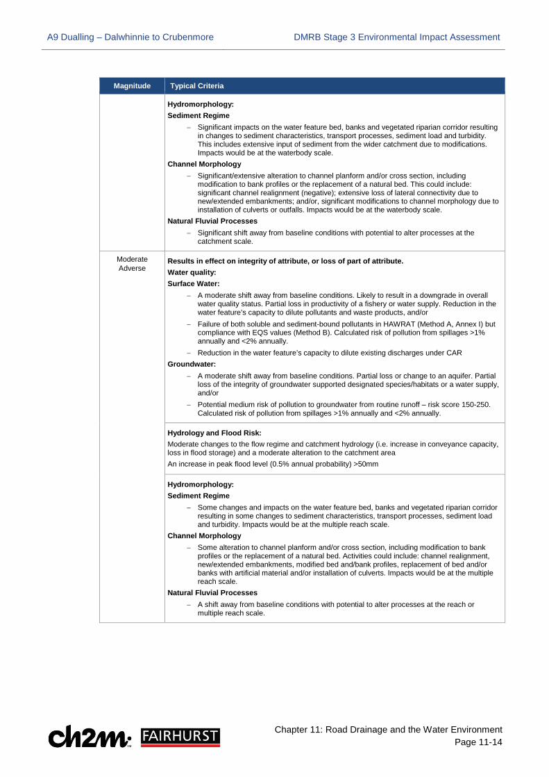
11.2.42 The magnitude of a potential impact is determined by the effect the impact could have on the sensitivity of the water feature or an associated attribute. Impacts may be beneficial or adverse and values range from ‘Major Adverse’ to ‘Major Beneficial’ as shown in Table 11-2.
Table 11-2 Magnitude of Impact
Magnitude Typical Criteria
Major Adverse Results in loss of attribute and/ or quality and integrity of the attribute. Water quality: Surface Water:
− Major shift away from baseline conditions such that change is likely to result in a downgrade in overall WFD water quality status and/or total removal of the water feature’s capacity to dilute pollutants and waste products and/ or loss or extensive change to a fishery, water supply or nature conservation site; and/or
− Failure of both soluble and sediment-bound pollutants in HAWRAT (Method A, Annex I) and compliance failure with EQS values (Method B). Calculated risk of pollution from a spillage >2% annually (Spillage Risk Assessment, Method D, Annex I).
− Total removal of the water feature’s capacity to dilute licensed discharges under CAR Groundwater:
− Major shift away from baseline conditions such as loss of, or extensive change to, an aquifer or extensive change to groundwater supported designated species/habitats or water supply; and/or
− Potential high risk of pollution to groundwater from routine runoff – risk score >250 (Groundwater Assessment, Method C, Annex I). Calculated risk of pollution from spillages >2% annually (Spillage Risk Assessment, Method D, Annex I).
Hydrology and Flood Risk: Major changes to flow regime and catchment hydrology (i.e. increase in conveyance capacity, loss in flood storage) and a major alteration to the catchment area. An increase in peak flood level (0.5% annual probability) > 100mm
A9 Dualling – Dalwhinnie to Crubenmore DMRB Stage 3 Environmental Impact Assessment
Chapter 11: Road Drainage and the Water Environment Page 11-14
Magnitude Typical Criteria
Hydromorphology: Sediment Regime
− Significant impacts on the water feature bed, banks and vegetated riparian corridor resulting in changes to sediment characteristics, transport processes, sediment load and turbidity. This includes extensive input of sediment from the wider catchment due to modifications. Impacts would be at the waterbody scale.
Channel Morphology − Significant/extensive alteration to channel planform and/or cross section, including
modification to bank profiles or the replacement of a natural bed. This could include: significant channel realignment (negative); extensive loss of lateral connectivity due to new/extended embankments; and/or, significant modifications to channel morphology due to installation of culverts or outfalls. Impacts would be at the waterbody scale.
Natural Fluvial Processes − Significant shift away from baseline conditions with potential to alter processes at the
catchment scale.
Moderate Adverse
Results in effect on integrity of attribute, or loss of part of attribute. Water quality: Surface Water:
− A moderate shift away from baseline conditions. Likely to result in a downgrade in overall water quality status. Partial loss in productivity of a fishery or water supply. Reduction in the water feature’s capacity to dilute pollutants and waste products, and/or
− Failure of both soluble and sediment-bound pollutants in HAWRAT (Method A, Annex I) but compliance with EQS values (Method B). Calculated risk of pollution from spillages >1% annually and <2% annually.
− Reduction in the water feature’s capacity to dilute existing discharges under CAR Groundwater:
− A moderate shift away from baseline conditions. Partial loss or change to an aquifer. Partial loss of the integrity of groundwater supported designated species/habitats or a water supply, and/or
− Potential medium risk of pollution to groundwater from routine runoff – risk score 150-250. Calculated risk of pollution from spillages >1% annually and <2% annually.
Hydrology and Flood Risk: Moderate changes to the flow regime and catchment hydrology (i.e. increase in conveyance capacity, loss in flood storage) and a moderate alteration to the catchment area An increase in peak flood level (0.5% annual probability) >50mm
Hydromorphology: Sediment Regime
− Some changes and impacts on the water feature bed, banks and vegetated riparian corridor resulting in some changes to sediment characteristics, transport processes, sediment load and turbidity. Impacts would be at the multiple reach scale.
Channel Morphology − Some alteration to channel planform and/or cross section, including modification to bank
profiles or the replacement of a natural bed. Activities could include: channel realignment, new/extended embankments, modified bed and/bank profiles, replacement of bed and/or banks with artificial material and/or installation of culverts. Impacts would be at the multiple reach scale.
Natural Fluvial Processes − A shift away from baseline conditions with potential to alter processes at the reach or
multiple reach scale.
A9 Dualling – Dalwhinnie to Crubenmore DMRB Stage 3 Environmental Impact Assessment
Chapter 11: Road Drainage and the Water Environment Page 11-15
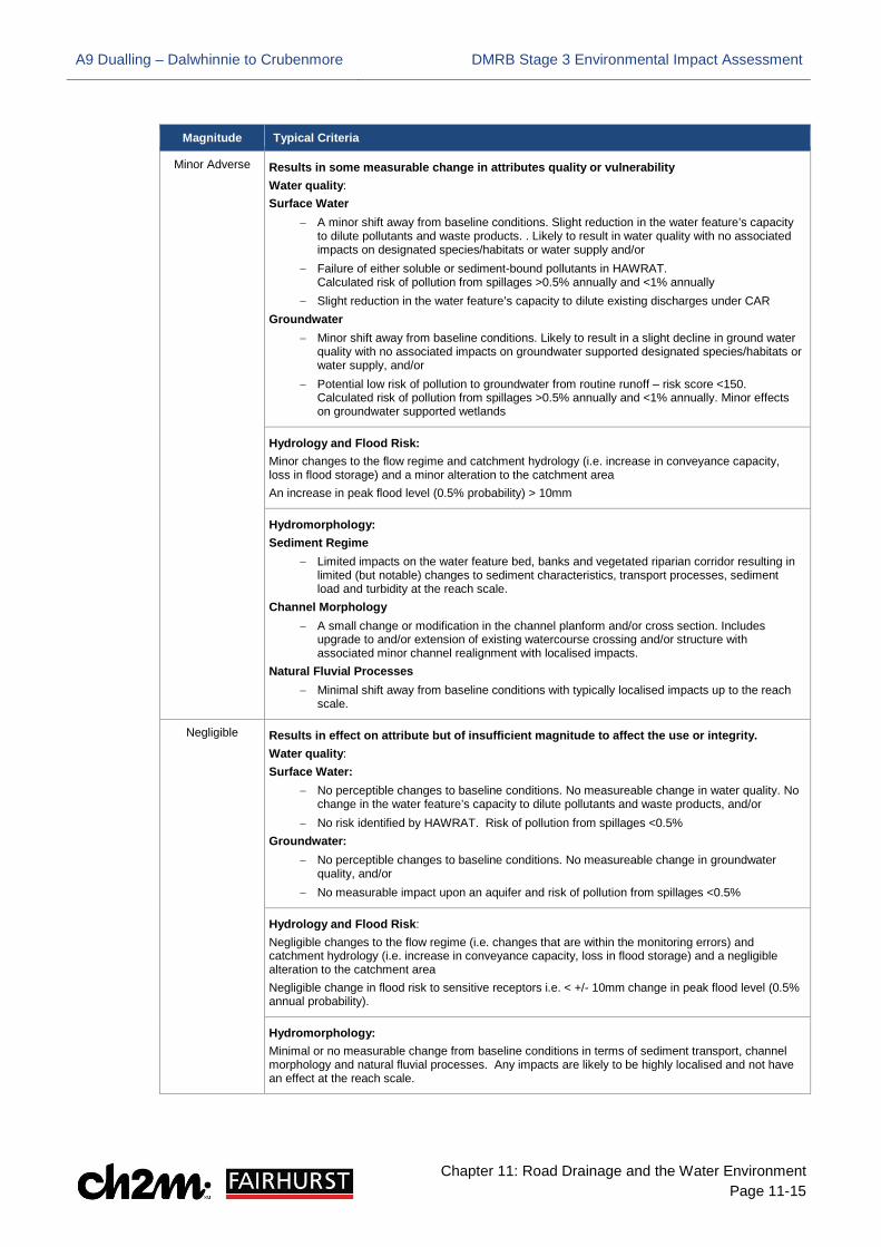
Magnitude Typical Criteria
Minor Adverse Results in some measurable change in attributes quality or vulnerability Water quality: Surface Water
− A minor shift away from baseline conditions. Slight reduction in the water feature’s capacity to dilute pollutants and waste products. . Likely to result in water quality with no associated impacts on designated species/habitats or water supply and/or
− Failure of either soluble or sediment-bound pollutants in HAWRAT. Calculated risk of pollution from spillages >0.5% annually and <1% annually
− Slight reduction in the water feature’s capacity to dilute existing discharges under CAR Groundwater
− Minor shift away from baseline conditions. Likely to result in a slight decline in ground water quality with no associated impacts on groundwater supported designated species/habitats or water supply, and/or
− Potential low risk of pollution to groundwater from routine runoff – risk score <150. Calculated risk of pollution from spillages >0.5% annually and <1% annually. Minor effects on groundwater supported wetlands
Hydrology and Flood Risk: Minor changes to the flow regime and catchment hydrology (i.e. increase in conveyance capacity, loss in flood storage) and a minor alteration to the catchment area An increase in peak flood level (0.5% probability) > 10mm
Hydromorphology: Sediment Regime
− Limited impacts on the water feature bed, banks and vegetated riparian corridor resulting in limited (but notable) changes to sediment characteristics, transport processes, sediment load and turbidity at the reach scale.
Channel Morphology − A small change or modification in the channel planform and/or cross section. Includes
upgrade to and/or extension of existing watercourse crossing and/or structure with associated minor channel realignment with localised impacts.
Natural Fluvial Processes − Minimal shift away from baseline conditions with typically localised impacts up to the reach
scale.
Negligible Results in effect on attribute but of insufficient magnitude to affect the use or integrity. Water quality: Surface Water:
− No perceptible changes to baseline conditions. No measureable change in water quality. No change in the water feature’s capacity to dilute pollutants and waste products, and/or
− No risk identified by HAWRAT. Risk of pollution from spillages <0.5% Groundwater:
− No perceptible changes to baseline conditions. No measureable change in groundwater quality, and/or
− No measurable impact upon an aquifer and risk of pollution from spillages <0.5%
Hydrology and Flood Risk: Negligible changes to the flow regime (i.e. changes that are within the monitoring errors) and catchment hydrology (i.e. increase in conveyance capacity, loss in flood storage) and a negligible alteration to the catchment area Negligible change in flood risk to sensitive receptors i.e. < +/- 10mm change in peak flood level (0.5% annual probability).
Hydromorphology: Minimal or no measurable change from baseline conditions in terms of sediment transport, channel morphology and natural fluvial processes. Any impacts are likely to be highly localised and not have an effect at the reach scale.

A9 Dualling – Dalwhinnie to Crubenmore DMRB Stage 3 Environmental Impact Assessment
Chapter 11: Road Drainage and the Water Environment Page 11-16
Magnitude Typical Criteria
Minor Beneficial Results in some beneficial effect on attribute or a reduced risk of negative effect occurring. Water quality: Surface Water:
− Minor improvement over baseline conditions, and/or Groundwater:
− Minor improvement over baseline conditions, and/or − Calculated reduction in existing spillage risk by 50% or more to an aquifer (when existing
spillage risk <1% annually)
Hydrology and Flood Risk: Minor improvement over baseline conditions involving a reduction in peak flood level (0.5% annual probability) > 10mm
Hydromorphology: Sediment Regime
− Partial improvement to sediment processes at the reach scale, including reduction in siltation and localised recovery of sediment transport processes.
Channel Morphology − Partial improvements include enhancements to in-channel habitat, riparian zone and
morphological diversity of the bed and/or banks. Natural Fluvial Processes
− Slight improvement on baseline conditions with potential to improve flow processes at the reach scale.
Moderate Beneficial
Results in moderate improvement of attribute quality Water quality: Surface Water:
− A moderate improvement over baseline conditions. Groundwater:
− A moderate improvement over baseline conditions e.g. calculated reduction in existing spillage risk by 50% or more (when existing spillage risk is >1% annually)
Hydrology and Flood Risk: Moderate improvement over baseline conditions involving a reduction in peak flood level (0.5% annual probability) >50mm
Hydromorphology: Sediment Regime
− Reduction in siltation and recovery of sediment transport processes at the reach or multiple reach scale.
Channel Morphology − Partial creation of both in-channel and vegetated riparian habitat. Improvement in
morphological diversity of the bed and/or banks at the reach or multiple reach scale. Includes partial or complete removal of structures and/or artificial materials.
Natural Fluvial Processes − Notable improvements on baseline conditions and recovery of fluvial processes at the reach
or multiple reach scale.

A9 Dualling – Dalwhinnie to Crubenmore DMRB Stage 3 Environmental Impact Assessment
Chapter 11: Road Drainage and the Water Environment Page 11-17
Magnitude Typical Criteria
Major Beneficial Results in major improvement of attribute quality Water quality: Surface Water:
− Major improvement over baseline conditions − Removal of existing polluting discharge, or removing the likelihood of polluting discharges
occurring to a watercourse Groundwater:
− Major improvement over baseline conditions − Removal of existing polluting discharge to an aquifer or removing the likelihood of polluting
discharges occurring. Recharge of an aquifer
Hydrology and Flood Risk: Major improvement over baseline conditions involving a reduction in peak flood level (0.5% annual probability) > 100mm.
Hydromorphology: Sediment Regime
− Improvement to sediment processes at the catchment scale, including recovery of sediment supply and transport processes.
Channel Morphology − Extensive creation of both in-channel habitat and riparian zone. Morphological diversity of
the bed and/or banks is restored, such as natural planform, varied natural cross-sectional profiles, recovery of fluvial features (e.g. cascades, pools, riffles, bars) expected for river type. Removal of modifications, structures, and artificial materials.
Natural Fluvial Processes − Substantial improvement on baseline conditions at catchment scale. Recovery of flow and
sediment regime.
Assigning Significance of Impact
11.2.43 The significance of a potential impact on the water feature is considered as a product of the sensitivity of the water feature and the magnitude of the potential impact; this is measured on a scale ranging from ‘Neutral’ to ‘Very Large’ (Table 11-3). Impacts may be considered ‘Adverse’ or ‘Beneficial’ depending on the sensitivity of the attribute and the magnitude of impact associated with the Proposed Scheme.
Table 11-3 Significance of impact
Magnitude of impact
Sensitivity of attribute
Negligible Minor Moderate Major
Very High Neutral Moderate/ Large Large/ Very large Very Large
High Neutral Slight/ Moderate Moderate/ Large Large/ Very Large
Medium Neutral Slight Moderate Large
Low Neutral Neutral Slight Slight/ Moderate
11.2.44 Significance is not absolute and where two options are available, the selection is based on professional judgement defined in relation to individual assets and their context and location. A higher level of significance is generally attached to large-scale impacts and impacts on highly sensitive or sensitive receptors; thus moderate magnitude impacts on highly sensitive receptors can be more important than major impacts on less sensitive receptors. Professional judgement is required to make a balanced and objective assessment taking all of these factors into account.

A9 Dualling – Dalwhinnie to Crubenmore DMRB Stage 3 Environmental Impact Assessment
Chapter 11: Road Drainage and the Water Environment Page 11-18
Limitations to the Assessment
11.2.45 There are certain limitations within each discipline with regards to assessment methodologies, as outlined below.
Water Quality
11.2.46 Although surface water quality data were obtained from SEPA for the DMRB Stage 3 assessment, no information was available for the watercourses within the Project 8 extent. Similarly, the majority of watercourses do not have a WFD classification, and therefore inferences regarding water quality are made based on other environmental factors. Where SEPA WFD classifications are available, a summary of these is provided in section 11.3.
11.2.47 DMRB methods are used to assess the effects of routine runoff on surface water and the impact of accidental spillages. Application of the surface water quality impact assessment methods set out in HD45/09 relies heavily on the use of HAWRAT. The following limitations associated with the use of HAWRAT have been identified:
• Water hardness data from surface water sampling was not available for the assessment and was assumed to be the lowest value available within the HAWRAT programme
• HAWRAT relies on 3 rainfall sites in Scotland – Edinburgh, Paisley and Ardtalnaig near Aberfeldy – sensitivity analysis has been undertaken to cater for the absence of data from rainfall sites within the Study Area and is reported in Appendix 11.2, (Volume 2)
• DMRB 33/16 provides removal efficiencies for input into HAWRAT; these are used indicatively rather than prescriptively. Required treatment percentages returned by HAWRAT are precise and may not take full account of site specific water feature attributes or characteristics. DMRB45/09 states “…a degree of pragmatism will be required when designing a drainage system to meet the required treatment percentages. The treatment train should be sufficient to reasonably treat the runoff”
Hydrology and Risk
11.2.48 Compensatory storage has not been modelled due to the complexity and uncertainty associated with representing this effectively in hydraulic models. These uncertainties are recognised in the Technical Flood Risk Guidance for Stakeholders (SEPA, 2015) and a volume-slices approach to evaluate compensatory storage is suggested. This method has been employed and accepted by SEPA and is described in greater detail, along with limitations relating to modelling uncertainties, in Appendix 11.3, (Volume 2).
Hydromorphology
11.2.49 Limitations to the hydromorphology assessment method used are as follows:
• The method used assumes that the works cause a change in WFD status classification of the waterbody, when in reality, the works are unlikely to cause a change in most cases
• Not all waterbodies have a current WFD classification; therefore, for many tributaries this has been assumed based on that of the larger river downstream classified by SEPA
• The length of channel affected by the works is based on a combination of the known length of direct impact, but the length of indirect impacts has been estimated based on expert judgement rather than sediment transport modelling

A9 Dualling – Dalwhinnie to Crubenmore DMRB Stage 3 Environmental Impact Assessment
Chapter 11: Road Drainage and the Water Environment Page 11-19
11.3 Baseline Conditions
Introduction
11.3.1 Baseline conditions are the current environmental state of the water features within the study area prior to the construction and operation of the Proposed Scheme. A full list of watercourses identified in the study area is provided in the schedule of the Water Features Survey along with sensitivity values for those watercourses subject to the pre- and post-mitigation assessment (Appendix 11.1, Volume 2). These watercourses are shown in the Water Features Plans (Drawings 11.1 to 11.9, Volume 3). Many of the watercourses within the Project 8 extent have been scoped-out of the environmental assessment, as explained in Section 11.2; therefore, only baseline conditions of those considered to be directly impacted by the Proposed Scheme are provided below.
11.3.2 All watercourses that cross the A9 are referred to by a water features reference number (i.e. ‘Major’ (MW) or ‘Minor’ (W)) and the structure (i.e. bridge or culvert) Hydro ID; those that do not cross the A9, but are still within the study area, are assigned a water feature reference number only.
11.3.3 Sensitive receptors are noted within the baseline assessment as they are considered to be determining factors within the existing water environment likely to be affected by, or affect, the Proposed Scheme.
Water Framework Directive
11.3.4 The WFD aims to improve and protect the water environment. Future targets include: prevent deterioration and enhance status of aquatic ecosystems, including groundwater; promote sustainable water use; reduce pollution; contribute to the mitigation of floods and droughts.
11.3.5 River Basin Management Plans (RBMPs) were produced as a requirement of the WFD by which statutory objectives, based on ecological assessments and economic judgments, are set for Scottish waters, and cover all types of water body (e.g. rivers, lochs, lakes, estuaries, coastal waters and groundwater). The RBMPs also:
• describe the current condition of our water bodies
• identify where current or historic activities are reducing the quality of the water bodies
• describe the actions required to ensure our designated waters of special value (for example, drinking waters, shellfish waters, bathing waters, and waters designated for their plants and animals) are up to required standards
• describe the actions needed to deliver environmental improvements over the next six years, and longer to 2027
11.3.6 The baseline information and WFD classifications are, therefore, used to ensure the Proposed Scheme will not have a deleterious/ detrimental effect on the WFD status of watercourses within the study area.
Common Baseline Conditions
11.3.7 The criteria under which the watercourse baselines are established, and against which the Proposed Scheme is assessed, are similar for most minor watercourses in the Project 8 extent. Therefore, a general ‘Common Baseline Conditions’ description is provided below for surface and ground water quality, hydrology and flood risk, and hydromorphology; thereafter, specific

A9 Dualling – Dalwhinnie to Crubenmore DMRB Stage 3 Environmental Impact Assessment
Chapter 11: Road Drainage and the Water Environment Page 11-20
attributes are described under ‘Specific Baseline Conditions’ with individual headings for major watercourses and other notable water features.
Surface Water Quality
11.3.8 As noted in section 11.2, no surface water quality data or WFD classification was available for DMRB Stage 3 assessment for many of the watercourses in the Project 8 extent. Therefore, inferences regarding water quality are made based on other environmental factors.
11.3.9 All watercourses in the Proposed Scheme flow through heterogeneous land cover types including some or all of the following: heather, rough grassland, heathland, peat, areas of coniferous woodland (plantations), and mires/ bogs/ fens. Therefore, the water quality of these watercourses may potentially be impacted by acidification. All watercourses will also receive a degree of road runoff from the existing A9 which may impact on water quality. It has been assumed that larger tributaries with good connectivity to the River Truim may support salmon species and so a conservative estimation of their water quality sensitivity has been adopted.
Groundwater Quality
11.3.10 The groundwater quality assessment has been undertaken using British Geological Survey (BGS) vulnerability classes. This approach amalgamates large spatial extents into common classes and has therefore, been delineated and reported here (Table 11-4) by chainage (ch.) rather than individual surface water features as elsewhere in this chapter. The groundwater vulnerability class associated to each individual watercourse is provided in the schedule of the Water Features Survey (Appendix 11.1, Volume 2).
Table 11-4 Summary of groundwater vulnerability
Chainage (ch.) Vulnerability class
20,000 to 20,050 Vulnerability class 4a – Vulnerable to those pollutants not readily adsorbed or transformed. Less likely to have clay present in superficial deposits (therefore, generally higher vulnerability than 4b)
20,050 to 21,100 Vulnerability class 3 – Vulnerable to some pollutants; many others significantly attenuated
21,100 to 21,350 Vulnerability class 4a
21,350 to 21,950 Vulnerability class 3
21,950 to 22,200 Vulnerability class 4a
22,200 to 22,250 Vulnerability class 5 – Vulnerable to most pollutants, with rapid impact in many scenarios
22,250 to 22,900 Vulnerability class 4a
22,900 to 24,050 Vulnerability class 3
24,050 to 25,200 Vulnerability class 4a
25,200 to 25,400 Vulnerability class 3
25,400 to 25,450 Vulnerability class 2 – Vulnerable to some pollutants, but only when continuously discharged/ leached
25,450 to 25,780 Vulnerability class 3
25,780 to 26,050 Vulnerability class 4a
26,050 to 26,570 Vulnerability class 3
26,050 to 26,570 Vulnerability class 3
26,570 to 31,050 Vulnerability class 4a
A9 Dualling – Dalwhinnie to Crubenmore DMRB Stage 3 Environmental Impact Assessment
Chapter 11: Road Drainage and the Water Environment Page 11-21
Hydrology and Flood Risk
11.3.11 Flooding from the River Truim is extensive throughout the Project 8 extent for the 1 in 200 return year period. The floodplains of both banks are inundated impacting on residential/ business properties (Dalwhinnie, Cuaich), utilities (electrical substation in Dalwhinnie), critical infrastructure (A9, A889, and HML railway), cultural heritage (Wade’s Bridge at ch. 21,200, Crubenmore Old Bridge at ch. 30,950) and sensitive environmental receptors identified by SEPA with potential economic implications, e.g. local agricultural land. Where applicable, flood risk from tributaries is discussed individually in the sections below.
Hydromorphology
11.3.12 The majority of the minor watercourses in the Project 8 extent have relatively short longitudinal profiles, ranging from a few hundred metres to approximately 1km, with largely straight channel planforms and confluence elevations ranging from 400m above ordnance datum (AOD) at Dalwhinnie to approximately 310m AOD at Crubenmore.
11.3.13 Many of the minor watercourse channels are narrow (i.e. between 0.5 and 1.5m wide), with few exhibiting significant geomorphic diversity. The terrain is dominated by heather, grassland and bog mosaics. On gentler gradients in close proximity to the A9, watercourses flow through established channels, both engineered and/ or following natural gradients over vegetation, where there is some deposition of small-grained materials, i.e. sands and silts.
11.3.14 To the east of the River Truim, watercourses drain the lower slopes of the Cairngorms and exhibit steeper gradients. These higher energy channels are more incised into local fluvio-glacial deposits, supplying larger volumes of sediment available for transport downstream. Some geomorphic diversity and fluvial processes are evident such as; bank erosion and the development of small lateral gravel bars, and deposition of gravel, pebble and cobble-sized materials. Several of the minor watercourses have engineering work in the form of gabion walls and mattresses, cascades and drops. These works are located where the watercourse is crossed by the existing A9.
Specific Baseline Conditions
Major Watercourses
River Truim (MW 8.1)
11.3.15 The River Truim is the dominant watercourse throughout the Project 8 extent, as shown in Drawings 11.1 to 11.9 (Volume 3). It is a major right bank tributary of the River Spey, draining the western edges of the Cairngorms with a catchment area of 125km2.
11.3.16 Its headwaters are situated in the Pass of Drumochter, approximately 8km south of Dalwhinnie. It has a WFD classification of ‘Good ecological potential’ – from source to Allt Cuaich confluence (2015), and ‘Moderate ecological potential’ – lower catchment (2015). It is designated as part of the River Spey Special Area of Conservation (SAC) for its populations of Atlantic salmon (Salmo salar) (the Truim is noted as important for its salmonid smolt production) and otter (Lutra lutra). (Sea lamprey (Petromyzon marinus) and freshwater pearl mussel (Margaritifera margaritifera) are also qualifying features of the River Spey SAC; no evidence has been determined in the River Truim Project 8 extents, however their presence has been assumed for assessment purposes.) It is situated in the Cairngorms National Park and its source is also within the Drumochter Hills Site of Special Scientific Interest (SSSI)/ SAC, as discussed in Chapter 12.

A9 Dualling – Dalwhinnie to Crubenmore DMRB Stage 3 Environmental Impact Assessment
Chapter 11: Road Drainage and the Water Environment Page 11-22
11.3.17 A number of residential, commercial and agricultural discharges are identified in the vicinity of the River Truim throughout the Project 8 extent. The majority are septic tanks to soakaway or to land greater than 50m from watercourses, with only one identified as a direct discharge to the Truim (DISC 8.5 at 263867, 785212 associated with Scottish Water treatment works in Dalwhinnie). However, as they may potentially follow subsurface pathways towards the larger watercourse, they are considered in the baseline conditions.
11.3.18 Overall, the watercourse has been assessed as having a Very High sensitivity value for water quality due to the various factors described above.
11.3.19 BGS data indicates that the waterbody is predominantly within a high groundwater vulnerability classification zone (Class 4); therefore a High sensitivity value for groundwater has been assigned.
11.3.20 The gentler gradients of the wider valley floors result in lower energy flows and subsequent deposition of this coarse material; this has been noted by channel narrowing at confluences with the River Spey. The watercourses within the catchment retain gravel-bed channels due to continued lateral migration; working into the glacial deposits, transporting and depositing materials exhibited by sinuous meandering and braided planforms and varied morphological features. Therefore, a High hydromorphological sensitivity value has been assigned.
11.3.21 The baseline hydraulic modelling highlights flooding of properties in Dalwhinnie and A889 at the 1 in 200 year return period in existing conditions. Therefore, a Very High sensitivity value has been assigned for flood risk.
Allt Coire nan Cisteachan (Hydro ID 72 & 73/ MW8.5)
11.3.22 Allt Coire nan Cisteachan is a right bank tributary of the River Truim with a catchment size of 1.64km2 and a length of approximately 2.4km flowing in a north-westerly direction from its source in the Cairngorms as shown in Drawing 11.2, (Volume 3). The watercourse is situated within the Drumochter Hills Mixed SSSI boundary (designated for Geomorphology: Fluvial geomorphology of Scotland, as well as biodiversity features). Potential salmonid spawning habitat is present immediately upstream and downstream of the crossing; however, a perched culvert will limit fish access; therefore a Low value has been assigned for water quality/ biodiversity.
11.3.23 BGS data indicates that the waterbody is within a medium groundwater vulnerability classification zone (Class 3); therefore a Medium sensitivity value has been assigned for groundwater.
11.3.24 There is evidence of the watercourse incising into bedrock and/ or superficial deposits with very large (cobble-small boulder) sediment deposited immediately upstream of the crossing. This indicates that at the highest flows, some of this large sediment will eventually be transmitted to the crossing; therefore, a High hydromorphology sensitivity value has been assigned.
11.3.25 Modelling identifies flooding which may potentially impact the A9, classed as essential infrastructure, and therefore a Very High sensitivity value has been assigned for flooding.

A9 Dualling – Dalwhinnie to Crubenmore DMRB Stage 3 Environmental Impact Assessment
Chapter 11: Road Drainage and the Water Environment Page 11-23
Photographs 11- 1: Allt Coire nan Cisteachan (Hydro ID 72 & 73/ MW 8.5)
a) Downstream looking at A9 from the west b) Upstream view looking at A9 from the east
Allt Coire Uilleim (Hydro ID 77/ MW 8.6)
11.3.26 Allt Coire Uilleim is a right-bank tributary of the River Truim. It has a catchment of 1.65km2, a length of approximately 3.4km and flows in a north-westerly direction from its source in the Cairngorms as shown in Drawing 11.3, (Volume 3). The watercourse is located within the Drumochter Hills Mixed SSSI boundary. Potential salmonid spawning habitat is present immediately upstream and downstream of the crossing; therefore a High value has been assigned for water quality/ biodiversity.
11.3.27 BGS data indicates that the waterbody is within a medium groundwater vulnerability classification zone (Class 4); therefore a High groundwater sensitivity value has been assigned.
11.3.28 Peat is present in the upper catchment with gullying, peat slides, hillslope slides, and vertical incision noted, resulting in a high potential for sediment supply in upper catchment; therefore a High sensitivity value has been assigned for hydromorphology.
11.3.29 A Very High sensitivity value has been assigned for flooding as modelling identifies flooding potentially impacting on the A9 and A889, both classed as critical infrastructure.
Photographs 11- 2: Allt Coire Uilleim (Hydro ID 77/ MW 8.6)
a) Downstream looking at A9 from the west b) Upstream view looking at A9 from the east
Allt Coire Bhathaich (Hydro ID 82/ MW 8.8)
11.3.1 Allt Coire Bhathaich is a tributary of the River Truim with a catchment of 4.54km2, a length of approximately 5.5km as shown in Drawing 11.3, (Volume 3). It flows firstly in a north-westerly direction from its source at Coire Bhathaich before shifting almost 90 degrees at Ruighe Coire Bhathaich (ch. 22,570) with a sinuous planform for much of its length discharging to the River Truim at ch. 22,330. It has been determined that this watercourse is not generally suitable for

A9 Dualling – Dalwhinnie to Crubenmore DMRB Stage 3 Environmental Impact Assessment
Chapter 11: Road Drainage and the Water Environment Page 11-24
spawning Atlantic salmon under current conditions as a result of SSE abstraction activities; therefore, a Low sensitivity has been assigned for water quality/ biodiversity.
11.3.2 BGS data indicates that the waterbody is within a very high groundwater vulnerability classification zone (Class 5); therefore, a Very High groundwater sensitivity value has been assigned.
11.3.3 It has been heavily modified by the construction of the A9 bridge crossing and a dam approximately 100m upstream from the bridge, with noted sediment accumulation behind the dam which also may impact pollutant dilution/ dispersal capacity; therefore, a High sensitivity value has been assigned for hydromorphology.
11.3.4 As the watercourse contributes to the hydro scheme and is considered to be locally important for social and economic uses (e.g. water supply/ abstraction; therefore, it has been assigned a High sensitivity for hydrology. Modelling identifies flooding which may potentially impact the A9, classed as critical infrastructure, a Very High sensitivity value has been assigned for flood risk.
Photographs 11- 3: Allt Coire Bhathaich (Hydro ID 82/ MW 8.8)
a) Upstream looking at A9 from the east b) View west from A9 c) Dam upstream of A9 crossing (ABS8.8)
Unnamed (Hydro ID 89/ MW 8.9)
11.3.5 This watercourse is a narrow unnamed right bank tributary of the River Truim which is currently piped under the SSE aqueduct as shown in Drawing 11.4 (Volume 3). It has a catchment of 0.57km2 and length of approximately 1km, flowing north parallel to the existing A9. It is not known to support any designated freshwater-dependent ecosystems and is outwith any designated sites; therefore, it has been assigned a Low sensitivity value for water quality/ biodiversity.
11.3.6 From its source, it drops from approximately 375mAOD to 370mAOD at the A9, with a further drop to approximately 350mAOD where it joins the River Truim at ch. 23,750. This natural channel has a sinuous planform and a range of sediment sizes forming the channel bed. The channel has been modified by a small weir installed upstream of the aqueduct directing water flow under the A9, reducing natural geomorphic processes downstream of this; however, a High hydromorphology sensitivity value has been assigned as much of the channel and flow is unmodified.
11.3.7 The inlet from the dam on the watercourse upstream (part of the SSE scheme) may affect the natural catchment hydrology. As the watercourse contributes to the hydro scheme, and modelling identifies flooding which may potentially impact the A9, classed as critical infrastructure, a Very High sensitivity value has been assigned for flooding.

A9 Dualling – Dalwhinnie to Crubenmore DMRB Stage 3 Environmental Impact Assessment
Chapter 11: Road Drainage and the Water Environment Page 11-25
Photographs 11- 4: Unnamed watercourse (Hydro ID 89/ MW8.9)
a) Dam east (upstream) of the A9 (ABS8.7) b) Upstream of the dam
Unnamed Tributary of the River Truim (Hydro ID 100/ MW8.12)
11.3.8 This unnamed watercourse is a tributary of the River Truim with a catchment of approximately 0.5km2, and a length of 1.25km as shown in Drawing 11.5, (Volume 3). It is not known to support any designated freshwater-dependent ecosystems and is outwith any designated sites; therefore, it has been assigned a Low sensitivity value for water quality/ biodiversity.
11.3.9 BGS data indicates that the water feature is within a medium groundwater vulnerability classification zone (Class 3); therefore, a Medium groundwater sensitivity has been assigned.
11.3.10 It has a source elevation of 370mAOD with a drop to 330mAOD at its confluence with the River Truim. It has a straightened stone protected channel, which flows predominantly through heather grassland upstream of the pipe crossing the A9, and a more sinuous pebble and gravel-bedded channel downstream flowing through coniferous woodland (Lechden) and rough grassland floodplain, and has been assigned a Medium sensitivity value for hydromorphology.
11.3.11 Modelling identifies upstream flooding, which may potentially impact the A9, as well as the watercourse flowing into an extensive flooded area east of the HML railway, both classed as critical infrastructure; therefore, the watercourse has been assessed as having a Very High flood risk sensitivity value.
Photographs 11- 5: Unnamed Tributary of the River Truim (Hydro ID 100/ MW 8.12)
a) Downstream west of A9 b) Upstream east of A9
A9 Dualling – Dalwhinnie to Crubenmore DMRB Stage 3 Environmental Impact Assessment
Chapter 11: Road Drainage and the Water Environment Page 11-26
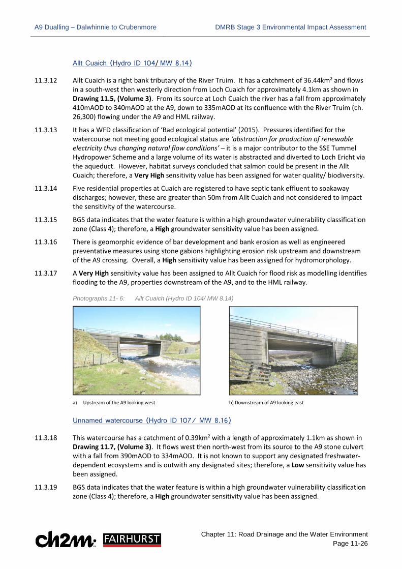
Allt Cuaich (Hydro ID 104/ MW 8.14)
11.3.12 Allt Cuaich is a right bank tributary of the River Truim. It has a catchment of 36.44km2 and flows in a south-west then westerly direction from Loch Cuaich for approximately 4.1km as shown in Drawing 11.5, (Volume 3). From its source at Loch Cuaich the river has a fall from approximately 410mAOD to 340mAOD at the A9, down to 335mAOD at its confluence with the River Truim (ch. 26,300) flowing under the A9 and HML railway.
11.3.13 It has a WFD classification of ‘Bad ecological potential’ (2015). Pressures identified for the watercourse not meeting good ecological status are ‘abstraction for production of renewable electricity thus changing natural flow conditions’ – it is a major contributor to the SSE Tummel Hydropower Scheme and a large volume of its water is abstracted and diverted to Loch Ericht via the aqueduct. However, habitat surveys concluded that salmon could be present in the Allt Cuaich; therefore, a Very High sensitivity value has been assigned for water quality/ biodiversity.
11.3.14 Five residential properties at Cuaich are registered to have septic tank effluent to soakaway discharges; however, these are greater than 50m from Allt Cuaich and not considered to impact the sensitivity of the watercourse.
11.3.15 BGS data indicates that the water feature is within a high groundwater vulnerability classification zone (Class 4); therefore, a High groundwater sensitivity value has been assigned.
11.3.16 There is geomorphic evidence of bar development and bank erosion as well as engineered preventative measures using stone gabions highlighting erosion risk upstream and downstream of the A9 crossing. Overall, a High sensitivity value has been assigned for hydromorphology.
11.3.17 A Very High sensitivity value has been assigned to Allt Cuaich for flood risk as modelling identifies flooding to the A9, properties downstream of the A9, and to the HML railway.
Photographs 11- 6: Allt Cuaich (Hydro ID 104/ MW 8.14)
a) Upstream of the A9 looking west b) Downstream of A9 looking east
Unnamed watercourse (Hydro ID 107/ MW 8.16)
11.3.18 This watercourse has a catchment of 0.39km2 with a length of approximately 1.1km as shown in Drawing 11.7, (Volume 3). It flows west then north-west from its source to the A9 stone culvert with a fall from 390mAOD to 334mAOD. It is not known to support any designated freshwater-dependent ecosystems and is outwith any designated sites; therefore, a Low sensitivity value has been assigned.
11.3.19 BGS data indicates that the water feature is within a high groundwater vulnerability classification zone (Class 4); therefore, a High groundwater sensitivity value has been assigned.

A9 Dualling – Dalwhinnie to Crubenmore DMRB Stage 3 Environmental Impact Assessment
Chapter 11: Road Drainage and the Water Environment Page 11-27
11.3.20 It flows under the A9 and HML railway at the confluence with the River Truim (ch. 26,830) at approximately 330mAOD. There appears to be erosion upstream, visible by deep-incised channel and deposition of material downstream at the culvert; therefore, a High sensitivity value has been assigned for hydromorphology.
11.3.21 The watercourse flows into the functional floodplain of the Truim; however, no sensitive receptors at risk from flooding are evident and so the watercourse is assigned a Low sensitivity value.
Photographs 11- 7: Unnamed watercourse (Hydro ID 107/ MW 8.16)
a) Downstream of the A9 looking west toward HML b) Upstream of the A9 looking west
Dalannach (Hydro ID 112/ MW 8.18)
11.3.22 This watercourse is an unnamed right bank tributary of the River Truim as shown in Drawing 11.7, (Volume 3). It has a catchment of 0.2km2, is approximately 2.6 km in length, flowing north to the pipe crossing the A9 then north-east, joining several other watercourses also culverted under A9 passing under the HML railway at ch. 29,100. Although classed as a Major watercourse, based on its poor connectivity to the River Truim, it is considered unlikely to support any designated fresh-water species; therefore, a Low sensitivity value has been assigned for water quality/ biodiversity.
11.3.23 BGS data indicates that the water feature is within a high groundwater vulnerability classification zone (Class 4); therefore, a High groundwater sensitivity has been assigned.
11.3.24 Downstream, bed cover is predominantly gravels and pebbles, and upstream there are larger boulder and cobble-sized materials. Upstream of the A9 pipe the channel is straightened and bound by stone bank protection. Overall, it has been assigned a Medium sensitivity value for hydromorphology.
11.3.25 The Truim flood extent further north acts as a barrier to the conveyance of flood water away from the area; therefore, it has been assigned a Low sensitivity value for flood risk.
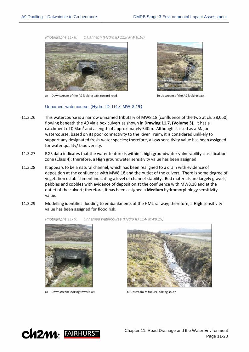
A9 Dualling – Dalwhinnie to Crubenmore DMRB Stage 3 Environmental Impact Assessment
Chapter 11: Road Drainage and the Water Environment Page 11-28
Photographs 11- 8: Dalannach (Hydro ID 112/ MW 8.18)
a) Downstream of the A9 looking east toward road b) Upstream of the A9 looking east
Unnamed watercourse (Hydro ID 114/ MW 8.19)
11.3.26 This watercourse is a narrow unnamed tributary of MW8.18 (confluence of the two at ch. 28,050) flowing beneath the A9 via a box culvert as shown in Drawing 11.7, (Volume 3). It has a catchment of 0.5km2 and a length of approximately 540m. Although classed as a Major watercourse, based on its poor connectivity to the River Truim, it is considered unlikely to support any designated fresh-water species; therefore, a Low sensitivity value has been assigned for water quality/ biodiversity.
11.3.27 BGS data indicates that the water feature is within a high groundwater vulnerability classification zone (Class 4); therefore, a High groundwater sensitivity value has been assigned.
11.3.28 It appears to be a natural channel, which has been realigned to a drain with evidence of deposition at the confluence with MW8.18 and the outlet of the culvert. There is some degree of vegetation establishment indicating a level of channel stability. Bed materials are largely gravels, pebbles and cobbles with evidence of deposition at the confluence with MW8.18 and at the outlet of the culvert; therefore, it has been assigned a Medium hydromorphology sensitivity value.
11.3.29 Modelling identifies flooding to embankments of the HML railway; therefore, a High sensitivity value has been assigned for flood risk.
Photographs 11- 9: Unnamed watercourse (Hydro ID 114/ MW8.19)
a) Downstream looking toward A9 b) Upstream of the A9 looking south
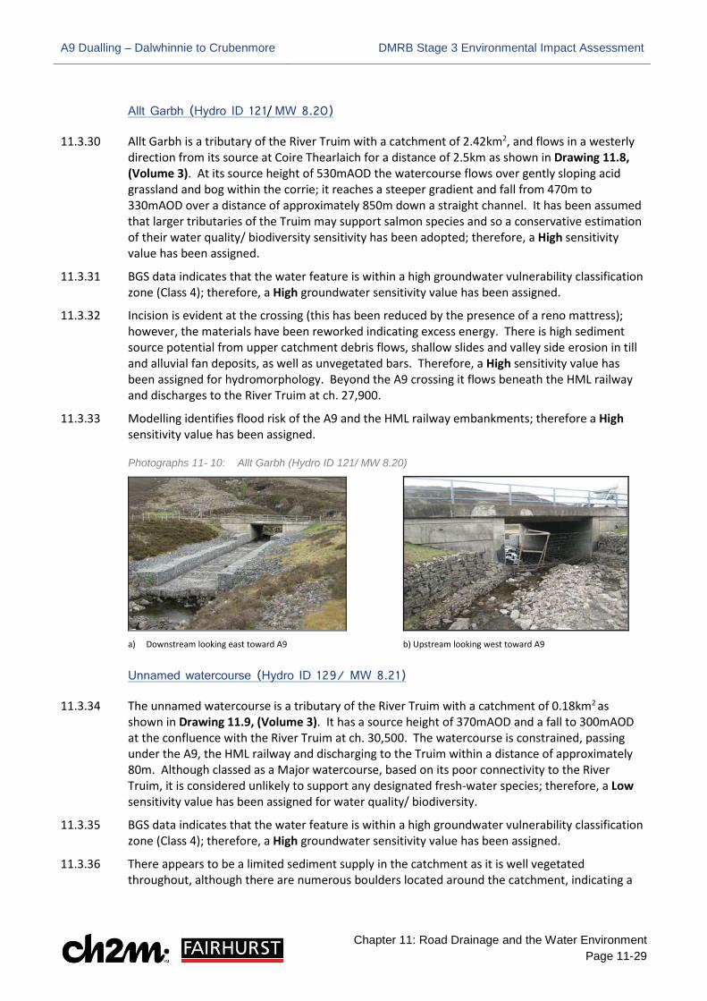
A9 Dualling – Dalwhinnie to Crubenmore DMRB Stage 3 Environmental Impact Assessment
Chapter 11: Road Drainage and the Water Environment Page 11-29
Allt Garbh (Hydro ID 121/ MW 8.20)
11.3.30 Allt Garbh is a tributary of the River Truim with a catchment of 2.42km2, and flows in a westerly direction from its source at Coire Thearlaich for a distance of 2.5km as shown in Drawing 11.8, (Volume 3). At its source height of 530mAOD the watercourse flows over gently sloping acid grassland and bog within the corrie; it reaches a steeper gradient and fall from 470m to 330mAOD over a distance of approximately 850m down a straight channel. It has been assumed that larger tributaries of the Truim may support salmon species and so a conservative estimation of their water quality/ biodiversity sensitivity has been adopted; therefore, a High sensitivity value has been assigned.
11.3.31 BGS data indicates that the water feature is within a high groundwater vulnerability classification zone (Class 4); therefore, a High groundwater sensitivity value has been assigned.
11.3.32 Incision is evident at the crossing (this has been reduced by the presence of a reno mattress); however, the materials have been reworked indicating excess energy. There is high sediment source potential from upper catchment debris flows, shallow slides and valley side erosion in till and alluvial fan deposits, as well as unvegetated bars. Therefore, a High sensitivity value has been assigned for hydromorphology. Beyond the A9 crossing it flows beneath the HML railway and discharges to the River Truim at ch. 27,900.
11.3.33 Modelling identifies flood risk of the A9 and the HML railway embankments; therefore a High sensitivity value has been assigned.
Photographs 11- 10: Allt Garbh (Hydro ID 121/ MW 8.20)
a) Downstream looking east toward A9 b) Upstream looking west toward A9
Unnamed watercourse (Hydro ID 129/ MW 8.21)
11.3.34 The unnamed watercourse is a tributary of the River Truim with a catchment of 0.18km2 as shown in Drawing 11.9, (Volume 3). It has a source height of 370mAOD and a fall to 300mAOD at the confluence with the River Truim at ch. 30,500. The watercourse is constrained, passing under the A9, the HML railway and discharging to the Truim within a distance of approximately 80m. Although classed as a Major watercourse, based on its poor connectivity to the River Truim, it is considered unlikely to support any designated fresh-water species; therefore, a Low sensitivity value has been assigned for water quality/ biodiversity.
11.3.35 BGS data indicates that the water feature is within a high groundwater vulnerability classification zone (Class 4); therefore, a High groundwater sensitivity value has been assigned.
11.3.36 There appears to be a limited sediment supply in the catchment as it is well vegetated throughout, although there are numerous boulders located around the catchment, indicating a

A9 Dualling – Dalwhinnie to Crubenmore DMRB Stage 3 Environmental Impact Assessment
Chapter 11: Road Drainage and the Water Environment Page 11-30
possible ready supply of coarse material below the vegetation. A Medium sensitivity value has been assigned for hydromorphology.
11.3.37 The downstream reach of this watercourse flows into the River Truim floodplain. No flooding of sensitive receptors has been identified by the hydraulic modelling; therefore, a Low sensitivity value has been assigned for flood risk.
Photographs 11- 11: Unnamed watercourse (Hydro ID 129/ MW8.21)
a) Downstream of A9 looking toward HML b) Cascade on upstream (east) side of A9
Allt na Ceardaich (Hydro ID 130/MW8.22)
11.3.38 Allt na Ceardaich is a tributary of the River Truim with a catchment area of 3.81km2 which flows in a westerly direction from its source (405mAOD) for approximately 1.6km to the Truim confluence (300mAOD) at ch. 30,750 as shown in Drawing 11.9, (Volume 3). Although classed as a Major watercourse, based on its poor connectivity to the River Truim, it is considered unlikely to support any designated fresh-water species; therefore, a Low sensitivity value has been assigned for water quality/ biodiversity.
11.3.39 BGS data indicates that the water feature is within a high groundwater vulnerability classification zone (Class 4); therefore, a High groundwater sensitivity value has been assigned.
11.3.40 The catchment contains a network of natural channels with unimpeded flow, sediment supply and sediment transport regime. These channels therefore display a wide range of geomorphological processes that contribute to the associated morphological diversity of form along most of the length of the main channel. The exception is the short, heavily engineered section associated with the road crossing where the channel has been straightened and the streambed laid with cobble bricks. Little to no natural geomorphic variation is evident locally at this location; however, overall a High sensitivity value has been assigned for hydromorphology to reflect the diverse nature of the majority of the channel.
11.3.41 A Very High sensitivity value has been assigned as modelling work identified flood risk to the A9 and the HML railway, both classed as critical infrastructure.

A9 Dualling – Dalwhinnie to Crubenmore DMRB Stage 3 Environmental Impact Assessment
Chapter 11: Road Drainage and the Water Environment Page 11-31
Photographs 11- 12: Allt na Ceardaich (Hydro ID 130/ MW8.22)
a) West of A9 looking upstream b) Looking downstream toward HML
Other Water Features
Scottish & Southern Energy (SSE) Aqueduct (A8.1)
11.3.42 The headwaters of the Spey in the south east of the catchment are controlled by Scottish & Southern Energy (SSE), and all the water used is diverted away from the Spey into Loch Ericht to the Tay catchment. There is one power station at Cuaich within the Spey catchment which forms part of the Tummel Valley Hydropower scheme, which contains a total of nine power stations1. Control features within the Project 8 extent include; Loch Cuaich (Cuaich Dam – capacity 1.68 million m3), Cuaich Aqueduct (Drawings 11.3 to 11.5, (Volume 3)), and Truim Intake (Drawing 11.3, (Volume 3)). There is no compensation flow agreement associated with these features.
11.3.43 The catchment draining to Loch Cuaich is increased by the aqueduct from Loch an t-Seilich and smaller aqueducts from Allt a’Choire Chais and Allt a’Choire Chaim. There is no requirement to release any compensation flow to the Allt Cuaich (MW8.14) downstream of Loch Cuaich which results in a dry river channel for much of the time and major loss of river habitat.
11.3.44 The intake on the River Truim does have a flow that is constantly released although it is not a true compensation flow. A flow of 0.684m3/s (13Mgal/d) is released continuously down through the fish-pass on the intake. The flow is measured downstream of the intake on the River Truim at Dalwhinnie and if the flow drops below 0.684m3/s, a valve is opened on the pipeline that feeds water from Allt Cuaich into Loch Ericht. However, as there are occasions when this pipe is empty for various operational reasons, this flow in the Truim is not guaranteed. The catchment of the River Truim to the intake is 36.3km2.
1 The Tummel scheme was initiated in the 1930s when the Grampian Electricity Supply Company built power stations at Rannoch and Tummel Bridge. The scheme was extended to the north and into the Spey in the 1940-50s. The water draining from the Spey catchment is very valuable to SSE as it provides ‘green’, renewable energy each time it flows through up to five hydro power stations before flowing out to the sea at Perth.

A9 Dualling – Dalwhinnie to Crubenmore DMRB Stage 3 Environmental Impact Assessment
Chapter 11: Road Drainage and the Water Environment Page 11-32
Photographs 11- 13: Scottish & Southern Energy (SSE) Aqueduct (A8.1)
a) West of A9 looking upstream b) East of A9 looking upstream
SSE Abstractions (ABS 8.6 to 8.16)
11.3.45 A series of impoundments, abstractions and returns are located within the Project 8 extent as part of the SSE Tummel Valley Hydropower scheme. The water from Loch Cuaich passes through Cuaich power station and the outflow is then diverted at the Allt Cuaich weir into the aqueduct (A8.1) and pipeline to Loch Ericht, picking up tributaries along its length via abstractions (ABS 8.6, 8.7, 8.9, 8.12, 8.13, 8.14, 8.15, and 8.16) as shown in Drawings 11.3 to 11.6 in Volume 3. Additional abstraction from Allt Coire Bhathaich (ABS 8.8) and the River Truim (ABS 8.10 and 8.11) also contribute to the SSE scheme (as shown in Drawing 11.3, Volume 3). As they contribute to, and support, vital social/ economic use they have been assigned a Very High sensitivity value.
Photographs: 11- 14 SSE Abstractions on MW8.8 and MW8.9
a) Abstraction (ABS 8.8) on MW8.8 upstream of A9 crossing b) Abstraction (ABS 8.7) on MW8.9 upstream of A9 crossing
Private Water Supplies
11.3.46 Private water supplies (PWS) are also identified within the Project 8 extent; however, despite being outwith the water environment study area boundary, they are deemed to be of very high sensitivity as they support vital social/ economic use and are, therefore, highlighted in this report for reference and shown on Drawings 11.3 and 11.9 in Volume 3. They include supplies at:
• Dalwhinnie Water Treatment Works (ABS 8.5) (ch. 23,050)
− Consultation with Scottish Water identified that the Dalwhinnie Water Treatment Works sources water for public supply and domestic use to the village of Dalwhinnie from three wells 3m deep located adjacent to the River Truim (Drawing 11.3, Volume 3)

A9 Dualling – Dalwhinnie to Crubenmore DMRB Stage 3 Environmental Impact Assessment
Chapter 11: Road Drainage and the Water Environment Page 11-33
• Dalwhinnie Beag (ABS 8.23) (ch. 23,550)
− The landowner believes that this property is serviced by the mains supply in Dalwhinnie (ABS 8.5). The PWS is therefore assumed to be inactive or possibly for local agricultural use (Drawing 11.4, Volume 3)
• Cuaich (ABS 8.24) (ch. 28,500)
− Water supplied to settlement of Cuaich from spring source to the east of the A9 via tank and pipe network that crosses the existing road south of Allt Cuaich (Drawing 11.5, Volume 3)
• Crubenmore (ABS 8.1) (ch. 30,650)
− The landowner identified a PWS sourced from a spring which supplies four properties (Crubenmore Lodge, Truim Cottage, Crubenmore Cottage and Crubenmore Chalet) (Drawing 11.8, Volume 3)
11.3.47 Additional PWS features identified as ABS 8.2 (Etteridge Farm), ABS 8.3 (Birch Cottage) and ABS 8.4 (Old Schoolhouse) in the Water Features Survey (Appendix 11.1 in Volume 2) were scoped-out from the assessment, as these are greater than 1km to the north of the Proposed Scheme. Landowner consultation did not identify any additional PWS features in the area.
Discharges
11.3.48 Consented point source discharges are identified from CAR licence information received from SEPA (Table 11-5). They include private residential, commercial and agricultural discharges associated with discharge of septic tank effluent (STE) to soakaways and occasionally land or surface watercourses. Although many are outwith the ‘DMRB Stage 3 Detailed Study Area’ they are considered here as they are located in the vicinity of watercourses identified as part of the baseline assessment and may have potential hydraulic connectivity to these via subsurface flows. Discharges include:
Table 11-5 Licenced Discharges within Project 8 Extent
Water Features Ref. Discharge Chainage
(approx.) Position and Distance
from Scheme Drawing
Number (in Volume 3)
DISC 8.13 1 & 2 Loch Ericht Cottage, Dalwhinnie (Private Contact) STE to soakaway ch. 22,600 145m west 11.3
DISC 8.14 1 Ben Alder Cottage, Dalwhinnie (Private Contact) STE to land ch. 22,600 75m west 11.3
DISC 8.15 Woodside Cottage, Dalwhinnie (Private Contact) STE to land ch. 22,600 40m west 11.3
DISC 8.16 Dalwhinnie Service Station, A889, Dalwhinnie (JIG Ltd) STE to soakaway ch. 22,600 Adjacent west 11.3
DISC 8.17 Dalwhinnie Office, Dalwhinnie (JIG Ltd) STE to soakaway ch. 22,600 65m west 11.3
DISC 8.18 Construction Yard, Dalwhinnie (Balfour Beatty Utility Solutions) ch. 22,800 250m west/ north 11.3
DISC 8.4 Dalwhinnie Water Treatment Works, Dalwhinnie (Scottish Water) TE to River Truim and potable water treatment and supply
ch. 24,425 400m west 11.3
DISC 8.19 Tigh Fhothannan, Dalwhinnie (Kirklands Law Ltd) STE to unnamed tributary of the River Truim ch. 23,400 300m west 11.4
DISC 8.5 Dalwhinnie Septic Tank (Scottish Water) FE to River Truim ch. 23,400 210m west 11.4

A9 Dualling – Dalwhinnie to Crubenmore DMRB Stage 3 Environmental Impact Assessment
Chapter 11: Road Drainage and the Water Environment Page 11-34
Water Features Ref. Discharge Chainage
(approx.) Position and Distance
from Scheme Drawing
Number (in Volume 3)
DISC 8.6 Dalwhinnie Distillery, Dalwhinnie (Diageo Scotland Ltd) TE from settlement lagoons to the River Truim.
ch. 24,400 200m west 11.4
DISC 8.7 No 4 Cuaich Cottages, Cuaich (Private Contact) STE to soakaway ch. 26,000 80m west 11.5
DISC 8.8 No 2 Cuaich Cottages, Cuaich (Private Contact) STE to soakaway ch. 26,000 80m west 11.5
DISC 8.9 No 1 Cuaich Cottages, Cuaich (Private Contact) STE to soakaway ch. 26,000 80m west 11.5
DISC 8.10 No 3 Cuaich Cottages, Cuaich (Private Contact) STE to soakaway ch. 26,000 200m west 11.6
DISC 8.11 No 5 Cuaich Cottages, Cuaich (Private Contact) STE to soakaway ch. 26,000 200m west 11.6
DISC 8.20 Breackachy, Laggan, Newtonmore (Breackachy) sheep dip disposal to land ch. 27,000 175m west 11.6
DISC 8.21 Breackachy, Laggan, Newtonmore (Breackachy) sheep dip disposal to land ch. 27,100 200m west 11.6
DISC 8.22 Breackachy, Laggan, Newtonmore (Breackachy) sheep dip disposal to land ch. 27,300 250m west 11.6
DISC 8.23 Crubenmore Lodge, Newtonmore (Ralia Enterprises) STE to soakaway ch. 30,700 50m west 11.8
DISC 8.24 Invertruim Cottage, Glentruim (Private Contact) STE to soakaway ch. 30,900 55m west 11.9
11.3.49 Further information on these discharges and additional potential contaminations sources is provided in Appendix 10.4 (Volume 2).
Project 7 – Glen Garry to Dalwhinnie (Central Section) Watercourses
11.3.50 Additional to the watercourses in the Project 8 extent, several watercourses to the south (within the Project 7 extent) are considered as part of the Potential Impacts of this chapter. This is due to the existing BDL access track, which runs parallel to the east of the A9, linking the two Projects. Baseline conditions of the major watercourses in the northern section of Project 7 are also included.
Allt Coire Chuirn (Hydro ID 59/ MW7.22)
11.3.51 The Allt Coire Chuirn has a catchment area of approximately 3.602km² and a length of 4.3km, generally flowing in a north-westerly direction, crossing under the existing A9 and NCN7 before discharging into the River Truim at NGR 263167, 780815, as shown in Drawing 11.1 (Volume 3). A High sensitivity value has been assigned for both water quality and biodiversity, given that there are likely to be only a small proportion of pollutant sources and as ecological permeability is facilitated within the span bridge crossing.
11.3.52 BGS data indicates that the Allt Coire Chuirn is situated within a high groundwater vulnerability zone (Class 4); therefore, it has been assigned a High groundwater quality sensitivity value.
11.3.53 The Allt Coire Chuirn is located within a steep sided V-shaped valley and an extensive sediment supply from the upper catchment is transported and deposited along a major alluvial fan. The fan is largely contained within the channel, which helps contribute towards active morphological processes and further sediment production. The existing A9 crossing creates a pinch-point which restricts the passage of sediment and debris movement; therefore, a High sensitivity value has been assigned for the hydromorphology.

A9 Dualling – Dalwhinnie to Crubenmore DMRB Stage 3 Environmental Impact Assessment
Chapter 11: Road Drainage and the Water Environment Page 11-35
11.3.54 The DMRB Stage 3 hydraulic model indicates that the Allt Coire Chuirn is associated with inundation of the HML railway embankment during a 1:200 year event, and therefore it has been assigned a High sensitivity value for hydrology and flood risk.
Photographs 11-14: Allt Coire Chuirn (Hydro ID 59/ MW 7.22)
a) Upstream view east of A9, showing areas of sediment deposition
b) Downstream view west of A9, showing pinch-point to
sediment movement
Allt Coire Bhotie (Hydro ID 64/ MW 7.23)
11.3.55 The Allt Coire Bhotie has a catchment area of approximately 1.363km² and a length of 3.1km, generally flowing in a north-westerly direction, crossing under the existing A9 before discharging into the River Truim at NGR 263676, 781545, as shown in Drawing 11.1 (Volume 3). A High sensitivity classification has been assigned for water quality given that there are likely to be only a small proportion of pollutant sources relative to watercourse flow.
11.3.56 BGS data indicates that the Allt Coire Bhotie is situated within a high groundwater vulnerability zone (Class 4); therefore, it has been assigned a High groundwater quality sensitivity value.
11.3.57 The Allt Coire Bhotie receives sediment supply from hillslope failure locations upstream, transported along a steep, confined channel. There is an area of sediment deposition adjacent to a section of channel realignment. Erosion downstream of the crossing has also resulted in channel incision and bank collapse; a High sensitivity value has been assigned for the hydromorphology of the Allt Coire Bhotie.
11.3.58 The DMRB Stage 3 hydraulic model indicates that the Allt Coire Bhotie is associated with inundation of the HML railway embankment during a 1:200 year event, and therefore it has been assigned a High sensitivity value for flood risk.

A9 Dualling – Dalwhinnie to Crubenmore DMRB Stage 3 Environmental Impact Assessment
Chapter 11: Road Drainage and the Water Environment Page 11-36
Photographs 11-15: Allt Coire Bhotie (Hydro ID 64/ MW 7.23)
a) Upstream view east of A9, showing areas of sediment
deposition adjacent to channel realignment
b) Downstream view west of A9, showing bank
collapse and a channel bar
Key receptors
11.3.59 Key sensitive receptors have been identified using a SEPA GIS receptor data shapefile. The vulnerability and sensitivity of receptors are also evaluated in line with the Scottish Planning Policy (SPP) Risk Framework. In terms of road drainage and the water environment, the key sensitive receptors within the Project 8 extent that may be affected by the Proposed Scheme include: residential and non-residential properties; roads, railway line; utilities; environmental designated sites; cultural heritage; community services; and agricultural land.
11.3.60 Specific receptors identified as potentially being at risk of flooding are; the HML railway, the BDL access track, Cuaich, and the A889/ NCN7. As essential infrastructure, the A9 itself is also identified as a sensitive receptor. The Proposed Scheme is designed above the 200 year flood level to ensure it remains operational in extreme events as per SPP.
11.3.61 Properties at Dalwhinnie and Crubenmore have also been identified as potentially being at risk of flooding in existing conditions. While these properties are outwith the Project 8 water environment study area boundary, it is required that no increase in flood risk occurs elsewhere as a result of the Proposed Scheme, they are therefore, considered as part of the Flood Risk Assessment (FRA) (Appendix 11.3, Volume 2).
Assigned sensitivities
11.3.62 As previously described, water feature sensitivity is derived from the importance of associated attributes. Whilst all water features do not have the same specific attributes, values have been assigned under the following principal headings as outlined in section 11.2:
• Water quality (including groundwater): Water quality, water supply, and biodiversity
• Hydrology/ flood risk: Catchment characteristics, environmental, economic and social value, flow conveyance and flood storage potential
• Hydromorphology: Sediment regime, channel morphology and fluvial processes
11.3.63 A detailed breakdown of individual watercourses and their associated attribute sensitivities is provided in the schedule of the Water Features Survey (Appendix 11.1, Volume 2). Where more

A9 Dualling – Dalwhinnie to Crubenmore DMRB Stage 3 Environmental Impact Assessment
Chapter 11: Road Drainage and the Water Environment Page 11-37
than one value is assigned to a single water feature, the relevant value of the associated attribute is assumed when determining the resulting significance of impact.
11.3.64 The potential impacts on each water feature vary across the Proposed Scheme dependent on the activity and specific attribute sensitivity assigned to each. These are discussed in more detail in section 11.4.
11.4 Potential Impacts
11.4.1 This section describes the potential impacts on the water environment that may arise as a result of the Proposed Scheme. Potential impacts to the Proposed Scheme itself as a result of water environment processes/ conditions (e.g. potential undermining of a road embankment by a watercourse in the medium to longer-term), and recommendations for periodic monitoring, are reported where relevant in the appropriate appendices.
Construction activities
11.4.2 Engineering works associated with the water environment include; construction of new/ replacement/ extended crossings of the A9 mainline (51 No.) and access tracks (31 No. including nine for BDL access track crossings) via pipes (900 to 2100mm) and box culverts (1500x1000mm to 3000x1500mm); earthworks associated with road widening; 178 watercourse realignments upstream and downstream of the Proposed Scheme mainline and access tracks; replacement of seven bridge structures (six mainline and one junction); 14 SuDS basins/ ponds and associated outfalls; drainage channels and associated outfalls; stepped channels or cascades; and compensatory flood storage areas to offset floodplain encroachments.
Embedded mitigation
11.4.3 Throughout the DMRB Stage 3 iterative design process, a number of environmentally-led workshops considered each aspect of the developing design and made recommendations for certain features to be included in the Proposed Scheme design. These aspects have been defined as 'embedded mitigation' and are considered within the context of the impact assessment as providing mitigation to avoid or reduce potential environmental impacts, and in some cases, provide environmental benefits.
11.4.4 With respect to the topics under consideration in this chapter, details of ‘embedded mitigation’ developed during the design process (now incorporated into the Proposed Scheme) are outlined in Table 11-6, with the potential operational impacts these measures are designed to mitigate also provided.
11.4.5 While the impact assessment is undertaken in cognisance of the embedded mitigation features, in order to ensure that all project mitigation requirements (including embedded, specific and generic mitigation) are captured, they have been included within section 11.5 of this chapter, and the Schedule of Environmental Commitments contained in Chapter 21.

A9 Dualling – Dalwhinnie to Crubenmore DMRB Stage 3 Environmental Impact Assessment
Chapter 11: Road Drainage and the Water Environment Page 11-38
Table 11-6 Potential Impacts and Embedded Mitigation
Potential Impacts Embedded Mitigation
Water Quality
• A wide range of pollutants can affect the water environment (e.g. soluble metals, suspended solids, organic materials, salts, rubber, plastics, grit, rust and metal filings, etc.) and pose a potentially hazardous threat to the environment as a result of increases in runoff volumes and predicted future traffic volumes
• The potential impact from drainage maintenance (e.g. cleaning of gully pots) has been identified as being as potentially damaging as some spillage impacts
• Maintaining verge and central reservation vegetation growth with the potential use of herbicides (or another form of chemical weed suppressant) may also contribute to contamination of road runoff*
• The routine application of road salt for de-icing (winter maintenance) could also impact adversely on downstream watercourse ecology, either directly through road surface drainage outfalls, or indirectly through groundwater
* Beyond the initial contractor maintenance period, regular inspection and maintenance schedules (including drainage networks and SuDS features) will be taken on by the relevant Trunk Road Operating Company and will be permanently maintained via Operating Company agreements.
• All un-kerbed roads are provided with ‘over-the-edge’ drainage via filter drains (or conveyance swales) providing source control and first treatment stage
• Watercourse capacity (Q95) assessed for pre-selection of outfall locations during SuDS design for avoidance of potential impact on smaller watercourses (i.e. watercourses with less dilution/ removal of waste products capacity)
• SuDS have been located outside flood extents (1 in 30 year for outfalls; 1 in 200 year for earthworks where possible) to minimise impacts on the water environment (avoids risk of overtopping and wash out of contaminated material)
• Additional (enhanced) treatment is provided where required to satisfy the water quality assessment (HAWRAT)
• Where infiltration has been assessed as inappropriate as a form of treatment, SuDS are lined to prevent groundwater contamination
• Inclusion of spillage containment features in SuDS facilities (emergency shut-off valve on basin outlet) to minimise spillage risk to receiving watercourses
Hydrology and Flood Risk
• An increase in impermeable area and reduction in infiltration capacity will increase overall runoff discharging to receiving watercourses
• The hydrology of watercourses may also become more 'flashy' compared to pre-scheme conditions, heightening hydrograph peak and increasing downstream flood risk and stream power. Road drainage too, will discharge to specified watercourses via an outfall. If attenuation is not suitably designed into the drainage system this may also have an impact on the hydrology and flood regime of receiving watercourses
• Floodplain storage may be reduced if there is encroachment by embankments, structures or earthworks. This loss would result in additional volumes of water potentially flooding areas elsewhere. Structures and culverts may restrict or increase conveyance causing water to back up and increase flood risk upstream, or facilitate greater flows to pass, thus increasing flood risk downstream. This is of particular concern if sensitive receptors have been identified either upstream or downstream of the Proposed Scheme
• Construction in floodplains can affect the nature and extent of the flood envelope in the area of construction and for some distance upstream and downstream. This could have a serious impact on property owners within or near the floodplain, who may become exposed to a new or increased risk of flooding. Bridges and embankments in particular, can obstruct or change the path of floodwaters, thereby changing the shape and/ or extent of the flood envelope
• Upsizing culverts for watercourse crossings to a minimum of 900mm, reducing the risk of blockage
• Upsizing culverts for watercourse crossings to have capacity for the 200yr design event including a freeboard allowance (where culverts are below 1200mm in height the freeboard is to be 300mm, otherwise freeboard is set to one quarter of the height)
• Raising road levels to accommodate for these increases (minimum of 2m above culvert crowns) and also provide greater freeboard above the functional floodplain
• Providing SuDS to mitigate increased surface runoff • Compensatory storage areas are included to offset flood storage volume lost due to
encroachments (mainline, access, SuDS) into the functional floodplain • Re-grading of certain cutting and embankment slopes to reduce floodplain encroachment • SuDS have been sized to control (attenuate and store) significant rainfall up to the 0.5%
AEP (1 in 200 year return period) event whilst restricting outflow to ‘greenfield’ runoff rates
• Dispersal trenches to maintain surface water supply to potentially sensitive habitats

A9 Dualling – Dalwhinnie to Crubenmore DMRB Stage 3 Environmental Impact Assessment
Chapter 11: Road Drainage and the Water Environment Page 11-39
Potential Impacts Embedded Mitigation
Hydromorphology
• Permanent loss of natural bed form where pipe culverts replace a natural (adjustable) channel bed and where outfall headwalls and bank protection works occur, reducing the morphological diversity of the channel and altering sediment supply at the location of engineering works, as well as downstream
• The permanent loss of natural bank form through installation of erosion protection, head walls, channel realignment and culverts, impacting the channel where banks are currently natural in form. The loss of natural bank form can result in reduced sediment supply from these areas which may impact processes and morphological diversity at both the site of works and downstream reaches
• Culverts, bank protection, headwalls and bridges all involve fixing the current position of the channel (planform and vertical), limiting the channel’s ability to respond to environmental change through channel adjustment. This may result in scour to the engineered structures and bed, potentially altering current processes and sediment regime, reducing the resilience of the channel to future changes in water and sediment inputs (climate and/ or land use change)
• All anticipated types of works have the potential to alter flow conditions (discharge and velocity, as well as flow patterns) within the channels. Changes from natural to engineered channels (addition/ extension of culverts, realignments, bridges) have a local adverse impact on flows in the waterbodies. Similarly, the outfalls and other areas where water is diverted across catchments alter the natural discharge of the channels, changing flow, sediment regime and potential processes away from the existing
• Significant steps (catchment pits, weirs etc.), culverts and channel diversions have the potential to alter the continuity of sediment transfer by causing excessive erosion or deposition
• Works may alter the sediment inputs to the channel, as well as changing the movement of sediment within the waterbody resulting in a change to sediment dynamics and natural processes within the channel at the location of the works and in the reaches downstream
• Excessive erosion of the proposed infrastructure (mainline or track embankments) has the potential to generate excessive sediment (as more sediment is available from the embankment than would be from the channel banks), and change patterns of deposition within the channels. Conversely areas of bank protection stop the inputs of sediment to the channel from erosion, also changing sediment dynamics
• Design bridges and culvert inlets/ outlets to minimise or avoid scour protection requirements
• Ensure low flow channels to maintain minimum depth of water • Setting back of structures from river banks to allow natural channel migration and
encourage sediment transfer through the catchment • Watercourse realignments designed with improved sinuosity to mimic natural sediment
regime/ morphological conditions and encourage establishment of natural sediment transfer/ processes
• Cascades follow natural topography where possible • Inclusion of scour pools upstream and downstream of steep culverts to dissipate energy • Reduce upstream erosion to improve stability of channels • Considered positioning of access tracks to improve watercourse morphology

A9 Dualling – Dalwhinnie to Crubenmore DMRB Stage 3 Environmental Impact Assessment
Chapter 11: Road Drainage and the Water Environment Page 11-40
Other Design Drivers Considered
11.4.6 Other design drivers also considered include:
• Operational factors (i.e. where maintenance issues require upsizing of culverts to ensure inspection and/ or debris removal can be carried out effectively; retaining existing pipe size as not to impact existing asset functionality)
• Ecological permeability (i.e. widening of underpasses with installation of dry ledges above extreme (normally 1 in 50yr) flood levels, and inclusion of natural bed materials to ensure that permeability throughout the route is maintained and improved where possible)
Specific Construction-phase Activities
11.4.7 Table 11-7 provides an outline of the specific construction-phase activities within the Proposed Scheme extent on or near the major watercourses described in section 11.3. Additional information regarding construction-phase (temporary) works is provided in Chapter 5.
11.4.8 Table 11-8 outlines the proposed SuDS treatments for the Project 8 drainage networks. Further detail on the impermeable and permeable areas associated with road runoff from the Proposed Scheme is provided in Appendix 11.2. Note: the permanent or operational-phase SuDS components should not be used to manage construction runoff.
Table 11-7 Summary of specific construction-phase activities on or near major water features
Water Feature Chainage (ch.)
Construction Activity
Allt Coire Chuirn (MW7.22/ Hydro ID 59)
8,400 (see note2)
Replacement of existing BDL access track crossing to the east of A9
Allt Coire Bhotie (north) (MW7.23/ Hydro ID 64)
9,375 (see note3)
Replacement of existing BDL access track crossing to the east of A9
Allt Coire nan Cisteachan (MW 8.5/ Hydro IDs 72 & 73)
20,750 Road widening and earthworks associated with new A9 southbound carriageway Removal of existing and construction of new Allt Coire nan Cisteachan underbridge Works (temporary and permanent) associated with SuDS 207 and access track
Allt Coire Uilleim (MW8.6/ Hydro ID 77)
21,450 Road widening and earthworks associated with new A9 southbound carriageway. Removal of existing and construction of new Allt Coire Uilleim underbridge
Approx. 30m south of Unnamed watercourse (W8.7/ Hydro ID 81)
22,050 Construction of a sheep hardstanding area. Location used twice per year to herd approximately two thousand animals for transportation
Allt Coire Bhathaich (MW8.8/ Hydro ID 82)
22,250 Road widening and earthworks associated with new A9 southbound carriageway and Dalwhinnie junction Construction of Allt Bhathaich Access crossing Removal of existing and construction of new Allt Coire Bhathaich underbridge Work associated with SuDS 222 and access track
2 Project 7 chainage numbering – equivalent to ch. -1,100 before the start of Project 8 3 Project 7 chainage numbering – equivalent to ch. -0,125 before the start of Project 8

A9 Dualling – Dalwhinnie to Crubenmore DMRB Stage 3 Environmental Impact Assessment
Chapter 11: Road Drainage and the Water Environment Page 11-41
Water Feature Chainage (ch.)
Construction Activity
River Truim (MW8.1) 22,500 Construction of new River Truim crossing and new access road from junction into Dalwhinnie Potential removal of existing Truim crossing
Unnamed watercourse (MW8.9/ Hydro ID 89)
23,330 Road widening and earthworks associated with new A9 southbound carriageway Extension of 450mm pipe (length = 111.5m) Upstream and downstream watercourse diversions Work associated with SuDS 233 and access track
Aqueduct (A8.1/ Hydro ID 89)
23,400 Removal of existing, and construction of new SSE Aqueduct Underbridge
Unnamed watercourse (tributary of River Truim) (MW8.12/ Hydro ID 100)
25,400 Road widening and earthworks associated with new A9 southbound carriageway Extension of 2400 x 1800 (length = 38m) with natural bed material to be included in culvert and provision of mammal crossing. Upstream and downstream watercourse diversions
Allt Cuaich (MW8.14/ Hydro ID 104)
26,000 Road widening and earthworks associated with new A9 southbound carriageway Removal of existing and construction of new Allt Cuaich underbridge Work associated with SuDS 258 & 259 Temporary crossing structure
Unnamed watercourse (MW8.16/ Hydro ID 107)
26,600 Road widening and earthworks associated with new A9 southbound carriageway Extension of 2400 x 1800 (length = 39.5m) with natural bed material to be included in culvert and provision of mammal crossing. Upstream and downstream watercourse diversions
Dalannach (MW8.18/ Hydro ID 112)
27,750 Road widening and earthworks associated with new A9 southbound carriageway Extension of 1500 x 1250 (length = 49.1m) with natural bed material to be included in culvert and provision of mammal crossing. Upstream and downstream watercourse diversions Work associated with SuDS 277 and access track
Unnamed watercourse (MW8.19/ Hydro ID 114)
27,980 Road widening and earthworks associated with new A9 southbound carriageway Extension of 2400 x 1200 (length = 43.1m) with natural bed material to be included in culvert and provision of mammal crossing. Upstream and downstream watercourse diversions
Allt Garbh (MW8.20/ Hydro ID 121)
29,150 Road widening and earthworks associated with new A9 northbound carriageway Removal of existing and construction of new Allt Garbh underbridge Works associated with new access track crossing
Unnamed watercourse (MW8.21/ Hydro ID 129)
30,500 Road widening and earthworks associated with new A9 northbound carriageway Extension of 1500 x 1250 (length = 35.3m) with natural bed material to be included in culvert and provision of mammal crossing. Upstream and downstream watercourse diversions
Allt na Ceardaich (MW8.22/ Hydro ID 130)
30,650 Road widening and earthworks associated with new A9 northbound carriageway Removal of existing and construction of new Allt Garbh underbridge Work associated with SuDS 306 and new access track crossing
Table 11-8 Summary of proposed SuDS features for drainage outfalls
SuDS ID 1st Level SuDS 2nd Level SuDS
Inclusion of Micro-pool
Outfall Form
Outfall receiving
water
Outfall Co-ordinates
Easting Northing
207 Filter Drain Basin No Swale Allt Coire Cisteachan 263953 782359
213 Filter Drain Basin No Swale Unnamed (W8.4) 263937 782969
214 Filter Drain Basin No Swale Unnamed (W8.4) 263916 783003
222 Filter Drain Basin No Pipe Allt Coire Bhathaich (MW8.8)
264026 783821

A9 Dualling – Dalwhinnie to Crubenmore DMRB Stage 3 Environmental Impact Assessment
Chapter 11: Road Drainage and the Water Environment Page 11-42
SuDS ID 1st Level SuDS 2nd Level SuDS
Inclusion of Micro-pool
Outfall Form
Outfall receiving
water
Outfall Co-ordinates
Easting Northing
DW1 Filter Drain Swale No Swale River Truim (MW8.1) 263760 784072
DW2 Filter Drain Swale No Swale River Truim (MW8.1) 263729 784170
DW3 Filter Drain N/A No Pipe River Truim (MW8.1) 263717 784258
225 Filter Drain Basin No Swale River Truim (MW8.1) 263743 784179
233 Filter Drain Basin No Swale Unnamed (MW8.9) 264252 784879
254 Filter Drain Basin Yes Swale River Truim (MW8.1) 265085 786776
258 Filter Drain Basin No Swale Allt Cuaich (MW8.14) 265715 787008
259 Filter Drain Basin No Swale Allt Cuaich (MW8.14) 265715 787008
277 Filter Drain Basin Yes Swale Unnamed (W8.22) 266626 788456
282 Filter Drain Basin Yes Swale Unnamed (MW8.19) 266984 788755
286 Filter Drain Basin Yes Swale Unnamed (MW8.19) 267319 789265
293 Filter Drain Basin Yes Pipe Unnamed (W8.167) 267583 789795
306 Filter Drain Basin No Swale Allt na
Ceardaich (MW8.22)
267723 791074
309 Filter Drain Tank Sewer and Vortex separator
No Pipe Existing Culvert 267723 791285
310 Filter Drain N/A No Pipe River Truim (MW8.1) 267757 791433
Potential Construction-phase Impacts
11.4.9 Potential construction-phase impacts that may occur as a result of the activities outlined in Table 11-7 are discussed below. These works are on major watercourses that will require CAR consent; however, the same approach and considerations are also given to all other non-major watercourses, and appropriate construction techniques and guidance should be followed.
11.4.10 As the methods of construction and the type of appropriate mitigation are unknown at this stage, the significance of potential impacts is not provided here; however, it is assumed that appropriate mitigation will be employed by the Contractor. Standard mitigation items to offset any potential construction-phase impacts are outlined in Table 11-10 of Section 11.5.
Water Quality (Surface Water)
11.4.11 A primary concern is pollution from mobilised suspended solids generated by excavation and movement of materials. Settlement of these materials may occur some distance from the site of

A9 Dualling – Dalwhinnie to Crubenmore DMRB Stage 3 Environmental Impact Assessment
Chapter 11: Road Drainage and the Water Environment Page 11-43
works and impact on the chemical and/ or ecological quality of a watercourse or other sensitive receptor.
11.4.12 Increased overland flow from removed vegetation and/ or compacted ground from heavy machinery may contribute to changes to surface water drainage and inhibit infiltration. As runoff from construction sites can have increased levels of toxic elements comparative to routine runoff, this can also have an adverse impact on the chemical and/ or ecological quality of a watercourse or other sensitive receptor. Accumulation of toxic substances contained in sediment and runoff may also have detrimental impacts on aquatic flora and fauna if degradation or dispersal does not occur in sufficient time. Toxic substances from already contaminated land may enter the water environment via remobilisation of sediment due to disturbance of land.
11.4.13 The proximity of construction to watercourses may be a crucial factor in determining risk of pollution. Spatial constrains may result in construction near channel banks causing instability or destruction and releasing suspended solid materials.
11.4.14 Runoff from stockpiles, vehicle washings, pumping excavations, spillage of fuels, lubricants, hydraulic fluids and cement from construction plant, and leakage from fuel and materials storage areas may lead to adverse environmental incidents.
11.4.15 Accidental spillages from washing of plant or release of sewage can enter and pollute watercourses and groundwater and cause adverse impacts on flora and fauna. Further construction pollution types and sources are outlined in CIRIA C648 (Table 3.1).
Water Quality (Groundwater)
11.4.16 There is potential to impact groundwater quality in the vicinity of the works, and further afield, as dewatering may cause ingress of contaminated groundwater to the surrounding area.
11.4.17 Disturbance of contaminated land may impact on SuDS basins if they are not appropriately designed. Those that contain infiltration components may not be suitable for particular sites as this may remobilise pollutants that are dormant in the ground. SuDS basins and filter drains could also act as pathways for contamination to enter groundwater. Incorporation of liners to prevent infiltration into the underlying ground will enable the use of basins, swales, wetlands, and ponds on sites.
11.4.18 Groundwater abstractions may be vulnerable to temporary disturbance from work within or adjacent to watercourses.
11.4.19 Should accidental spillages occur during construction or operation, contamination may impact on groundwater within superficial deposits or bedrock and impair local groundwater quality. BGS information on groundwater vulnerability in Project 8 indicates all groundwater is vulnerable to this. However, the areas at highest risk are those in the vicinity of widenings and cuttings anticipated to intercept groundwater. Further detail is provided in Chapter 10.
Hydrology and Flood Risk
11.4.20 Potential impacts on hydrology and flood risk during construction of the Proposed Scheme may include; alteration of catchments (e.g. watercourse diversions), culvert and bridge construction resulting in flow constrictions, dewatering works, temporary drainage (e.g. drains, ditches, swales and SuDS) affecting hydrological and flow regimes on downstream watercourses, interception of groundwater flow causing waterlogging or groundwater flooding, and increased flood risk downstream or elsewhere of the Proposed Scheme due to change in runoff characteristics (e.g. increased runoff due to removal of vegetation and topsoil cover).
A9 Dualling – Dalwhinnie to Crubenmore DMRB Stage 3 Environmental Impact Assessment
Chapter 11: Road Drainage and the Water Environment Page 11-44
11.4.21 Temporary watercourse diversions (e.g. diverting water from the SSE aqueduct into the Allt Cuaich) may impact salmon migration. Sensitive timing of work would be needed i.e. avoiding the autumn upstream salmon migration; therefore, construction should only be undertaken between January - June/ July.
11.4.22 Localised flood risk may be increased by the presence of construction materials and/ or plant. These impacts are likely to be more severe during periods of intense or prolonged rainfall and construction on floodplains may reduce storage capacity, also increasing flood risk in the vicinity of works.
11.4.23 Temporary haul roads may cause a temporary increase in runoff due to reduced infiltration rates within the footprint of the works.
11.4.24 DMRB HD45/09 outlines construction methods that may also increase flood risk:
• Temporary paved surfaces or roofed areas of site compounds may increase the rate of runoff
• Any works within the floodplain are likely to affect the local hydrology
• Ditch or drainage diversions may affect catchment characteristics
• Temporary bunding or material stockpiles may alter runoff from upstream areas
• Large areas stripped of vegetation can discharge runoff at a much higher rate than if grassed, and some provision for temporary storage of surface water may be needed
Hydromorphology
11.4.25 By their nature culverts, bridges, realignments, and bank protection pose a risk to the geomorphology of the channel and floodplain as significant proportions of the required works (e.g. excavation, construction and landscaping) are located within, or in close proximity to, watercourses. Examples of potential impacts include:
• Damage to bank form
− Engineering within the channel (culverts, bank protection, realignment, bridges and headwalls) may destabilise and permanently change the form of its banks
• Damage to bed form
− Construction works within the channel may damage existing bed form (including areas of gravel bars, pools and steps), bed armouring and sediment composition of the bed. Works may also release fine sediment during construction that can potentially smother gravels at the site and further downstream, affecting ecological receptors
• Increased sediment supply
− As both bed and banks may potentially become destabilised by the works, remobilised material is more likely to be delivered to the channel, and therefore, entrained and transported downstream
• Change in sediment dynamics
− Increased sediment supply can lead to a change in sediment dynamics within the channel at the site of works, as well as downstream, and is likely to result in increased downstream transport and/or local deposition

A9 Dualling – Dalwhinnie to Crubenmore DMRB Stage 3 Environmental Impact Assessment
Chapter 11: Road Drainage and the Water Environment Page 11-45
• Change in flow conditions
− Any temporary narrowing of the channel to create a dry working environment will alter the discharge, velocity and water levels of the channel
• Change of continuity of sediment transfer (excessive deposition or erosion)
− Methods of construction that include impeding downstream sediment transport (e.g. damming the channel or over-pumping of water downstream) will temporarily reduce the downstream continuity of sediment transfer during the works, having an adverse impact on sediment continuity
Potential Operational-phase Impacts
11.4.26 All potential impacts have been assessed using the methods outlined in section 11.2. A summary of potential impacts discussed in Appendices 11.2 to 11.4 (Volume 2) is provided below. Only impacts with significance greater than Neutral (adverse or beneficial) are included in Table 11-9, with a summary of the sensitivity, magnitude of impact, and significance of impacts outlined also provided. Additional information regarding all operational-phase (permanent) works is provided in Chapter 5.
Water Quality (Surface Water)
11.4.27 No potential impact to water quality or adverse effect on aquatic ecology has been identified for individual SuDS outfalls, as sufficient embedded mitigation has been incorporated into the Proposed Scheme design. Therefore, an overall Neutral significance has been determined. Further details are provided in Appendix 11.2. Further details are provided in Appendix 11.2 (Volume 2).
Water Quality (Groundwater)
11.4.28 With appropriate embedded mitigation (e.g. lining SuDS to prevent dispersal of potentially polluted road runoff to ground), groundwater quality not be adversely impacted as a result of routine runoff or accidental spillage. Furthermore, the risk of accidental spillage is significantly below the ‘1 in 200 year’ threshold set by HD45/09.
Hydrology
11.4.29 As a result of watercourse diversions and proposed drainage layout, several catchment areas within the Project 8 extent will be altered. A change less than 1% (+/-) is not considered significant and not reported here; therefore, a total of twelve watercourses catchments have been assessed.
11.4.30 With the exception of Allt Coire Bhathaich (MW8.8/ Hydro ID 82), all of these watercourses have been assigned Low sensitivities for hydrology. Overall, the potential impact for these watercourses is assessed as Major Adverse magnitude and Slight Adverse significance.
11.4.31 As the watercourses are little more than heavily engineered road drainage channels, draining boggy flat land, the alteration of catchment sizes is not deemed to be detrimental to the River Truim (as part of the Spey SAC) as the diverted waters ultimately discharge to the River Truim via tributaries or directly to the main channel, and therefore, no loss of water from the catchment is envisaged.

A9 Dualling – Dalwhinnie to Crubenmore DMRB Stage 3 Environmental Impact Assessment
Chapter 11: Road Drainage and the Water Environment Page 11-46
11.4.32 Allt Coire Bhathaich (MW8.8/ Hydro ID 82) contributes to the SSE Tummel Hydropower Scheme via a dam upstream of Hydro ID 82. Therefore, as it contributes to critical social and economic uses, it has been determined as having a High sensitivity. Overall, the potential impact on this watercourse as a result of change to catchment size is assessed as Minor Adverse magnitude and Slight Adverse significance.
11.4.33 As the change to catchment size is a result of several smaller watercourses to the north being diverted to Allt Coire Bhathaich in order to make way for the junction at Dalwhinnie, there will not be a reduction in area contributing to the SSE abstraction; therefore the impact is unlikely to adversely impact SSE operations.
Flood Risk
11.4.34 The FRA identifies changes in flood levels for a 1 in 200-year event at discrete sensitive receptor locations throughout the Proposed Scheme extent i.e. where the receptor is within the functional floodplain. For the majority, the difference in water level between existing and proposed conditions found the significance of impact to be Negligible.
11.4.35 Consideration has also been given to potential impacts identified in the vicinity of a sensitive receptor where the change in water level would result in a significance of impact greater than neutral (e.g. adjacent to the HML railway rather than at the location of the receptor itself). The proximity between the receptor and flood extent, as well as the relative height difference between the peak water level and receptor, has been taken into account when determining the significance of impact.
11.4.36 The flood modelling results indicate a section of the A9 (ch. 20,350 to 20,750) that is currently at risk of overtopping and flooding the road in a 200-year event from watercourse W8.38/ Hydro ID 67. The Proposed Scheme removes this risk as the mainline is raised above the floodplain and predicted to be free of flooding in a 200-year event. Therefore, as the watercourse is assigned a Very High sensitivity, and the magnitude of impact is deemed Minor Beneficial, the overall significance of impact is Large Beneficial.
11.4.37 Modelling indicates that flood levels are predicted to rise by 320mm immediately upstream of the Allt Cuaich (MW8.14) crossing (Hydro ID 104) adjacent to the A9. In accordance with SEPA and SPP guidelines, a compensatory storage area (CSA) was included during design development into the Proposed Scheme upstream of crossing Hydro ID 104 to offset this increase in flood levels. However, subsequent hydraulic modelling determined the CSA ineffective and a potential flow route through an adjacent underpass to downstream properties was identified. Therefore, as the sensitivity of the watercourse has been determined as Very High for flood risk and the magnitude of impact Major Adverse, the overall significance of impact is Very Large Adverse. However, the proposed A9 road level is 4m higher than peak flood water levels and therefore, not directly impacted in a 200-year event. Additional mitigation proposals are suggested in section 11.5.
11.4.38 Flood levels are predicted to rise between 600mm and 90mm adjacent to the HML railway at ch. 29,300 to ch. 29,350 and ch. 29,400 to ch. 29,450, respectively. As the sensitivity of the associated watercourses is has been determined as High for flood risk and the magnitude of impact Major Adverse, the overall significance of impact is Large Adverse. However, the HML railway remains approximately 2m above the peak water level and therefore not directly impacted in a 200-year event.

A9 Dualling – Dalwhinnie to Crubenmore DMRB Stage 3 Environmental Impact Assessment
Chapter 11: Road Drainage and the Water Environment Page 11-47
Hydromorphology
11.4.39 The hydromorphology one watercourses crossing has been found to be adversely impacted. Scheme design requirements/ mitigation measures necessitate that culverts are not upsized and channel realignments are included at crossing Hydro ID 100 (W8.13). This may potentially cause adverse impacts on flows and sediment transport within this channel. The watercourse has been assigned a Medium sensitivity for hydromorphology; therefore the overall potential impact is assessed as Minor Adverse magnitude and Slight Adverse significance.

A9 Dualling – Dalwhinnie to Crubenmore DMRB Stage 3 Environmental Impact Assessment
Chapter 11: Road Drainage and the Water Environment Page 11-48
Table 11-9: Summary of potential operational-phase impacts
Receptor Chainage (ch.) Detail of potential impact(s) Sensitivity Magnitude Significance
of Impact
Hydrology
Catchment of Hydro ID 78/ W8.57 ch. 21,600
A change in overall catchment area of this watercourse is a result of water being drained north to Hydro ID 79. The existing catchment is small (0.03km2); therefore, the diversion results in a change of area of -30%. As the watercourse is not considered sensitive in terms of its hydrological importance, the magnitude of change results only in a slight adverse significance of impact.
Low Major Adverse
Slight Adverse
Catchment of Hydro ID 82 (Allt Coire Bhathaich/ MW8.8)
ch. 22,250
Diversion of water from Catchment 83 due to the Dalwhinnie junction earthworks. The percentage of area change is +2.5% and, therefore, the overall significance of impact is not deemed to be detrimental; the use of this watercourse as part of the SSE hydro scheme will not be compromised as waters is not being diverted out of the catchment.
High Minor Adverse
Slight Adverse
Catchment of Hydro ID 83/ W8.67 ch. 22,420
The total diversion of this watercourse to Hydro ID 82 to the south, results in a change to its catchment area of -100%. However, as the watercourse is not considered sensitive in terms of its hydrological importance, the magnitude of change results only in a slight adverse significance of impact.
Low Major Adverse
Slight Adverse
Catchment of Hydro ID 84/ W8.72 ch. 22,660
The total diversion of this watercourse to Hydro ID 85 to the north, results in a change to its catchment area of -100%. However, as the watercourse is not considered sensitive in terms of its hydrological importance, the magnitude of change results only in a slight adverse significance of impact.
Low Major Adverse
Slight Adverse
Catchment of Hydro ID 85/ W8.74 ch. 22,750
As this is a small catchment (0.01km2), increase in area from the diversion from Catchment 84 results in an overall change to area of +1200%. However, as the watercourse is not considered sensitive in terms of its hydrological importance, the magnitude of change results only in a slight adverse significance of impact.
Low Major Adverse
Slight Adverse
Catchment of Hydro ID 86/ W8.75 ch. 22,810
As this is a small catchment (0.04km2), a -17.3% change in area from the relocation of Hydro ID 86 further north to accommodate the new Dalwhinnie junction. As the watercourse is not considered sensitive in terms of its hydrological importance, the magnitude of change results only in a slight adverse significance of impact.
Low Moderate Adverse
Slight Adverse
Catchment of Hydro ID 90/ W8.87 ch. 23,420
An overall increase in catchment size of +72.8% is due to diversion of water from Catchments 91 and 92 to the north. As the watercourse is not considered sensitive in terms of its hydrological importance, the magnitude of change results only in a slight adverse significance of impact.
Low Major Adverse
Slight Adverse
Catchment of Hydro ID 91/ W8.88 ch. 23,500
The total diversion of this watercourse to combine with Hydro ID 90 to the south results in a change to its catchment area of -100%. As the watercourse is not considered sensitive in terms of its hydrological importance, the magnitude of change results only in a slight adverse significance of impact.
Low Major Adverse
Slight Adverse
Catchment of Hydro ID 92/ W8.89 ch. 23,500
The total diversion of this watercourse to combine with Hydro ID 93 to the north results in a change to its catchment area of -100%. This water course has (existing conditions) an overflow into the SSE aqueduct – the current proposals ensure that it backs up and over flows in a similar manner to the existing arrangement in order that operations are not detrimentally impacted
Low Major Adverse
Slight Adverse
Catchment of Hydro ID 93/ W8.90 ch. 23,700
The increase in total area of +68% of this catchment is a result of the diversion of water from ID 92 to the south. Current proposals ensure that it backs up and over flows into the aqueduct in order that SSE operations are not detrimentally impacted
Low Major Adverse
Slight Adverse
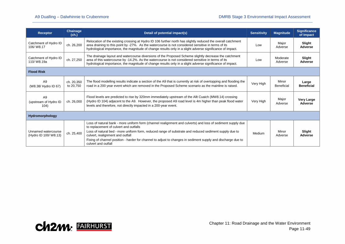
A9 Dualling – Dalwhinnie to Crubenmore DMRB Stage 3 Environmental Impact Assessment
Chapter 11: Road Drainage and the Water Environment Page 11-49
Receptor Chainage (ch.) Detail of potential impact(s) Sensitivity Magnitude Significance
of Impact
Catchment of Hydro ID 106/ W8.17 ch. 26,200
Relocation of the existing crossing at Hydro ID 106 further north has slightly reduced the overall catchment area draining to this point by -27%. As the watercourse is not considered sensitive in terms of its hydrological importance, the magnitude of change results only in a slight adverse significance of impact.
Low Major Adverse
Slight Adverse
Catchment of Hydro ID 110/ W8.19a ch. 27,250
The drainage layout and watercourse diversions of the Proposed Scheme slightly decrease the catchment area of this watercourse by -14.2%. As the watercourse is not considered sensitive in terms of its hydrological importance, the magnitude of change results only in a slight adverse significance of impact.
Low Moderate Adverse
Slight Adverse
Flood Risk
A9 (W8.38/ Hydro ID 67)
ch. 20,350 to 20,750
The flood modelling results indicate a section of the A9 that is currently at risk of overtopping and flooding the road in a 200 year event which are removed in the Proposed Scheme scenario as the mainline is raised. Very High Minor
Beneficial Large
Beneficial
A9 (upstream of Hydro ID
104) ch. 26,000
Flood levels are predicted to rise by 320mm immediately upstream of the Allt Cuaich (MW8.14) crossing (Hydro ID 104) adjacent to the A9. However, the proposed A9 road level is 4m higher than peak flood water levels and therefore, not directly impacted in a 200-year event.
Very High Major Adverse
Very Large Adverse
Hydromorphology
Unnamed watercourse (Hydro ID 100/ W8.13) ch. 25,400
Loss of natural bank - more uniform form (channel realignment and culverts) and loss of sediment supply due to replacement of culvert and outfalls Loss of natural bed - more uniform form, reduced range of substrate and reduced sediment supply due to culvert, realignment and outfall Fixing of channel position - harder for channel to adjust to changes in sediment supply and discharge due to culvert and outfall
Medium Minor Adverse
Slight Adverse

A9 Dualling – Dalwhinnie to Crubenmore DMRB Stage 3 Environmental Impact Assessment
Chapter 11: Road Drainage and the Water Environment Page 11-50
11.5 Mitigation
Standard A9, Embedded and Project Specific Mitigation
11.5.1 There are standard A9 mitigation measures that are common to the A9 Dualling Programme. A number of the measures have been identified as being relevant to reduce the overall impacts of the Proposed Scheme on Road Drainage and the Water Environment, as listed in Table 11-9.
11.5.2 As noted in section 11.4, embedded Mitigation measures are project specific and are included in the design of the Proposed Scheme. For clarity, these are included in Table 11-11 where relevant to this chapter. Note the initial impact assessment has included consideration of these measures.
11.5.3 There is also project specific mitigation, which includes additional mitigation measures which have been identified as part of this EIA process and which apply specifically to Road Drainage and the Water Environment affected by the Proposed Scheme. These are listed in Table 11-12.
11.5.4 The location of mitigation items (embedded and additional) is provided in Drawings 11.21 to 11.29 (Volume 3).
11.5.5 The ‘Timing of Measure’ provided in Tables 11-10 to 11-12 refers to the implementation of the mitigation measure. This could mean that implementation of the measure requires further work during contractor design and at construction, e.g. to work up detailed design and method statements to install an underpass, or an outfall and then implement during construction.

A9 Dualling – Dalwhinnie to Crubenmore DMRB Stage 3 Environmental Impact Assessment
Chapter 11: Road Drainage and the Water Environment Page 11-51
Table 11-10 Standard Mitigation Commitments for Protection of the Water Environment
Mitigation Item
Approximate Chainage/ Location
Timing of Measure Description Mitigation Purpose/
Objective Specific
Consultation or Approval Required
Standard A9 Mitigation SMC-W1 Throughout
proposed scheme
Design, Pre-Construction & Construction
In relation to authorisations under CAR, the Contractor will be required to provide a detailed Construction Method Statement which will include proposed mitigation measures for specific activities including any requirements identified through the pre-CAR application consultation process.
To mitigate construction impacts on the water environment.
CAR applications require approval from SEPA
SMC-W2 Throughout proposed scheme
Pre-Construction & Construction
In relation to flood risk, the Contractor will implement the following mitigation measures during construction: • The Flood Response Plan (as part of the CEMP, refer to Mitigation Item SMC-S1 in Table 21-1 of Chapter
21 (Schedule of Environmental Commitments)) will set out the following mitigation measures to be implemented when working within the functional floodplain (defined here as the 0.5% AEP (200-year) flood extent): Routinely check the Met Office Weather Warnings and the SEPA Floodline alert service for potential
storm events (or snow melt), flood alerts and warnings relevant to the area of the construction works. During periods of heavy rainfall or extended periods of wet weather (in the immediate locality or wider
river catchment) river levels will be monitored using for example SEPA Water Level Data when available/ visual inspection of water features. The Contractor will assess any change from base flow condition and be familiar with the normal dry weather flow conditions for the water feature, and be familiar with the likely hydrological response of the water feature to heavy rainfall (in terms of time to peak, likely flood extents) and windows of opportunity to respond should river levels rise.
Should flooding be predicted, works close or within the water features should be immediately withdrawn (if practicable) from high risk areas (defined as: within the channel or within the bankfull channel zone - usually the 50% (2-year) AEP flood extent). Works should retreat to above the 10% AEP (10-year) flood extent) with monitoring and alerts for further mobilisation outside the functional floodplain should river levels continue to rise.
• Plant and materials will be stored in areas outside the functional floodplain where practicable, with the aim for temporary construction works to be resistant or resilient to flooding impacts, to minimise/ prevent movement or damage during potential flooding events. Where this is not possible, agreement will be required with the Environmental Clerk of Works (EnvCoW).
• Stockpiling of material within the functional floodplain, if unavoidable, will be carefully controlled with limits to the extent of stockpiling within an area, to prevent compartmentalisation of the floodplain, and stockpiles will be located >10m from watercourse banks.
• Temporary drainage systems will be implemented to alleviate localised surface water flood risk and prevent obstruction of existing surface runoff pathways. Where practicable, temporary haul routes will be located outside of the functional floodplain.
To reduce the risk of flooding impacts on construction works.
None required

A9 Dualling – Dalwhinnie to Crubenmore DMRB Stage 3 Environmental Impact Assessment
Chapter 11: Road Drainage and the Water Environment Page 11-52
Mitigation Item
Approximate Chainage/ Location
Timing of Measure Description Mitigation Purpose/
Objective Specific
Consultation or Approval Required
SMC-W3 Throughout proposed scheme
Pre-Construction Construction & Post-Construction/ Operation
In relation to construction site runoff and sedimentation, the Contractor will adhere to GPPs/ PGGs (SEPA, 2006-2017) and other good practice guidance (Section 11.2), and implement appropriate measures which will include, but may not be limited to: • avoiding unnecessary stockpiling of materials and exposure of bare surfaces, limiting topsoil stripping to
areas where bulk earthworks are immediately programmed • installation of temporary drainage systems/ SuDS systems (or equivalent) including pre-earthworks
drainage • pre-earthworks drainage/ SuDS with appropriate outfalls to be in place prior to any earthworks activities • treatment facilities to be scheduled for construction early in the programme, to allow settlement and
treatment of any pollutants contained in site runoff and to control the rate of flow before water is discharged into a receiving watercourse
• the adoption of silt fences, check dams, settlement lagoons, soakaways and other sediment trap structures as appropriate
• the maintenance and regrading of haulage route surfaces where issues are encountered with the breakdown of the existing surface and generation of fine sediment
• provision of wheel washes at appropriate locations (in terms of proposed construction activities) and >10m from water features
• protecting soil stockpiles using bunds, silt fencing and peripheral cut-off ditches, and location of stockpiles at distances >10m from water features; and
• restoration of bare surfaces (seeding and planting) throughout the construction period as soon as possible after the work has been completed, or protecting exposed ground with geotextiles if to be left exposed
To implement appropriate controls for site runoff and sedimentation and reduce impacts on the water environment.
If flocculants are considered necessary to aid settlement of fine suspended solids, such as clay particles, the chemicals used must first be approved by SEPA. Where required, temporary discharge consents to be obtained from SEPA through the Water Environment (Controlled Activities) (Scotland) Regulations 2011 (as amended).
SMC-W4 Throughout proposed scheme
Pre-Construction & Construction
In relation to in-channel working, the Contractor will adhere to GPPs/ PPGS (SEPA, 2006-2017) and other good practice guidance (Section 11.2), and implement appropriate measures which will include, but may not be limited to: • undertaking in-channel works during low flow periods (i.e. when flows are at or below the mean average)
as far as reasonably practicable to reduce the potential for sediment release and scour • no in-channel working during the salmonid spawning seasons unless permitted within any CAR licence • minimise the length of channel disturbed and size of working corridor, with the use of silt fences or bunds
where appropriate to prevent sediment being washed into the water feature • limit the removal of vegetation from the riparian corridor, and retaining vegetated buffer zone wherever
reasonably practicable • limit the amount of tracking adjacent to watercourses and avoid creation of new flow paths between
exposed areas and new or existing channels.
To reduce impacts on the water environment during in-channel working.
Method statements for any in-channel working require approval by SEPA

A9 Dualling – Dalwhinnie to Crubenmore DMRB Stage 3 Environmental Impact Assessment
Chapter 11: Road Drainage and the Water Environment Page 11-53
Mitigation Item
Approximate Chainage/ Location
Timing of Measure Description Mitigation Purpose/
Objective Specific
Consultation or Approval Required
SMC-W5 Throughout proposed scheme
Construction Where channel realignment is necessary, the Contractor will adhere to good practice guidance (Section 11.2) and implement appropriate measures which will include, but may not be limited to: • Once a new channel is constructed, the flow should, where practicable, be diverted from the existing
channel to the new course under normal/ low flow conditions • diverting flow to a new channel should be timed to avoid forecast heavy rainfall events at the location and
higher up in the catchment (the optimum time will be the spring and early summer months to allow vegetation establishment to help stabilise the new channel banks)
• with offline realignments, the flow will be diverted with a steady release of water into the newly constructed realignment to avoid entrainment of fine sediment or erosion of the new channel
• any proposed realignment works will be supervised by a suitably qualified fluvial geomorphologist.
To reduce impacts on the water environment where channel realignment is proposed.
Consultation with SEPA
SMC-W6 Throughout proposed scheme
Construction In relation to refuelling and storage of fuels, the Contractor will adhere to GPPs/ PPGs (SEPA, 2006-2017) and other good practice guidance (Section 11.2), and implement appropriate measures which will include, but may not be limited to: • only designated trained and competent operatives will be authorised to refuel plant • refuelling will be undertaken at designated refuelling areas (e.g. on hardstanding, with spill kits available,
and >10m from water features) where practicable • appropriate measures will be adopted to avoid spillages (refer to Mitigation Item SMC-W7) • compliance with the Pollution Incident Control Plan (refer to Mitigation Item SMC-S1).
To avoid spillages and reduce impacts on the water environment in relation to refuelling.
None required
SMC-W7 Throughout proposed scheme
Construction In relation to oil/ fuel leaks and spillages, the Contractor will adhere to GPPs/ PPGs (SEPA, 2006-2017) and other good practice guidance (Section 11.2), and implement appropriate measures which will include, but may not be limited to: • stationary plant will be fitted with drip trays and emptied regularly • plant machinery will be regularly inspected for leaks with maintenance as required • spillage kits will be stored at key locations on-site and detailed within the Construction Environmental
Management Plan (CEMP) (refer to Mitigation Item S1) • construction activities will comply with the Pollution Incident Control Plan (refer to Mitigation Item SMC-S1)
To reduce impacts on the water environment in relation to oil/ fuel leaks and spillages.
None required
SMC-W8 Throughout proposed scheme
Construction In relation to chemical storage, handling and reuse, the Contractor will adhere to GPPs/ PPGs (SEPA, 2006-2017) and other good practice guidance (Section 11.2), and implement appropriate measures which will include, but may not be limited to: • chemical, fuel and oil storage will be undertaken within a site compound, which will be located on stable
ground at a low risk of flooding and >10m from any watercourse • chemical, fuel and oil stores will be locked and sited on an impervious base within a secured bund with
110% of the storage capacity • pesticides, including herbicides, will only be used if there are no alternative practicable measures, and will
be used in accordance with CAR requirements, the manufacturer’s instructions and application rates.
To reduce impacts on the water environment in relation to chemical storage, handling and reuse.
None required
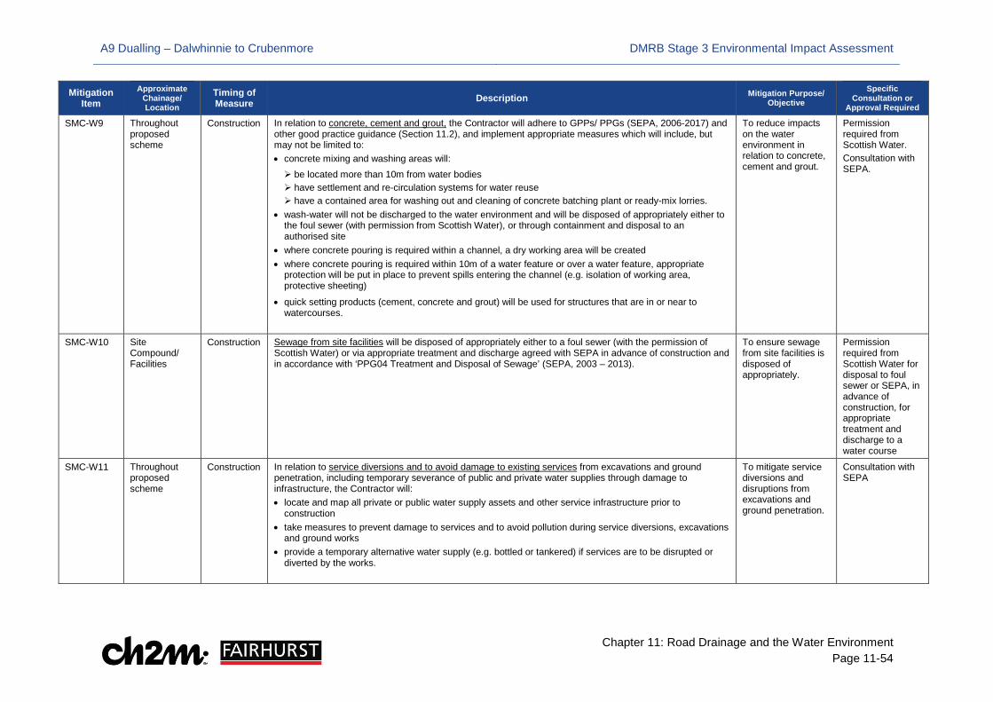
A9 Dualling – Dalwhinnie to Crubenmore DMRB Stage 3 Environmental Impact Assessment
Chapter 11: Road Drainage and the Water Environment Page 11-54
Mitigation Item
Approximate Chainage/ Location
Timing of Measure Description Mitigation Purpose/
Objective Specific
Consultation or Approval Required
SMC-W9 Throughout proposed scheme
Construction In relation to concrete, cement and grout, the Contractor will adhere to GPPs/ PPGs (SEPA, 2006-2017) and other good practice guidance (Section 11.2), and implement appropriate measures which will include, but may not be limited to: • concrete mixing and washing areas will: be located more than 10m from water bodies have settlement and re-circulation systems for water reuse have a contained area for washing out and cleaning of concrete batching plant or ready-mix lorries.
• wash-water will not be discharged to the water environment and will be disposed of appropriately either to the foul sewer (with permission from Scottish Water), or through containment and disposal to an authorised site
• where concrete pouring is required within a channel, a dry working area will be created • where concrete pouring is required within 10m of a water feature or over a water feature, appropriate
protection will be put in place to prevent spills entering the channel (e.g. isolation of working area, protective sheeting)
• quick setting products (cement, concrete and grout) will be used for structures that are in or near to watercourses.
To reduce impacts on the water environment in relation to concrete, cement and grout.
Permission required from Scottish Water. Consultation with SEPA.
SMC-W10 Site Compound/ Facilities
Construction Sewage from site facilities will be disposed of appropriately either to a foul sewer (with the permission of Scottish Water) or via appropriate treatment and discharge agreed with SEPA in advance of construction and in accordance with ‘PPG04 Treatment and Disposal of Sewage’ (SEPA, 2003 – 2013).
To ensure sewage from site facilities is disposed of appropriately.
Permission required from Scottish Water for disposal to foul sewer or SEPA, in advance of construction, for appropriate treatment and discharge to a water course
SMC-W11 Throughout proposed scheme
Construction In relation to service diversions and to avoid damage to existing services from excavations and ground penetration, including temporary severance of public and private water supplies through damage to infrastructure, the Contractor will: • locate and map all private or public water supply assets and other service infrastructure prior to
construction • take measures to prevent damage to services and to avoid pollution during service diversions, excavations
and ground works • provide a temporary alternative water supply (e.g. bottled or tankered) if services are to be disrupted or
diverted by the works.
To mitigate service diversions and disruptions from excavations and ground penetration.
Consultation with SEPA

A9 Dualling – Dalwhinnie to Crubenmore DMRB Stage 3 Environmental Impact Assessment
Chapter 11: Road Drainage and the Water Environment Page 11-55
Mitigation Item
Approximate Chainage/ Location
Timing of Measure Description Mitigation Purpose/
Objective Specific
Consultation or Approval Required
SMC-W12 Throughout proposed scheme
Construction For works within areas identified as potentially containing contaminated land and sediment the Contractor will reduce the risk of surface water pollution to an acceptably low level through:
• further site investigation to determine the level of contamination prior to construction to beginning • the installation of temporary treatment facilities to enable removal of pollutants from surface waters • adoption of mitigation measures relating to contaminated land as outlined in Table 21-5
To reduce risk of surface water pollution from areas identified as potentially contaminated land to an acceptably low level.
Details of any temporary treatment measures to be agreed with SEPA prior to commencement of construction
SMC-W13 Throughout proposed scheme
Design In relation to bank reinforcement, design principles and mitigation measures will adhere to good practice (SEPA, 2008), which will include, but may not be limited to: • non-engineering solutions and green engineering (e.g. vegetation, geotextile matting) to be the preference
during options appraisal • requirements for grey engineering to control/ prevent scour (e.g. rock armour, rip-rap, gabion baskets) to
be minimised • post project appraisal to identify if there are issues that can be investigated and addressed at an early
stage
To reduce impacts of in-channel structures on the water environment.
Consultation with SEPA
SMC-W14 Throughout proposed scheme
Design In relation to outfalls, specimen and detailed design will ensure compliance with good practice (e.g. CIRIA, 2015; The Highways Agency et al., 2004; SEPA, 2008), which will include, but may not be limited to: • directing each outfall downstream to minimise impacts to flow patterns • avoiding projecting the outfall into the watercourse channel • avoid installation of outfalls at locations of known historical channel migration • avoid positioning in flow convergence zones or where there is evidence of active bank erosion/ instability • directing an outfall away from the banks of a river to minimise any potential risk of erosion (particularly on
the opposite bank) • minimising the size/ extent of the outfall headwall where possible to reduce the potential impact on the
banks • post project appraisal to identify if there are issues that can be investigated and addressed at an early
stage
To reduce impacts of outfalls on the water environment.
Consultation with SEPA

A9 Dualling – Dalwhinnie to Crubenmore DMRB Stage 3 Environmental Impact Assessment
Chapter 11: Road Drainage and the Water Environment Page 11-56
Mitigation Item
Approximate Chainage/ Location
Timing of Measure Description Mitigation Purpose/
Objective Specific
Consultation or Approval Required
SMC-W15 Throughout proposed scheme
Design In relation to watercourse crossings, specimen and detailed design will ensure compliance with good practice (SEPA, 2010), which will include, but may not be limited to: • Detailed design will mitigate flood risk impacts through appropriate hydraulic design of culvert structures.
Flood risk will be assessed against the 0.5%AEP (200-year) plus an allowance for climate change design flood event. Detailed design will mitigate any loss of existing floodplain storage volume where required by appropriate provision of compensatory storage. Where culvert extension is not practicable or presents adverse impact on the water environment, appropriately designed replacement culverts may be installed.
• Detailed design will mitigate impacts on the water environment through appropriate design of culvert structures and watercourse modifications (e.g. realignments) with respect to fluvial geomorphology, and both riparian and aquatic ecology.
• Detailed design of culverts and associated watercourse modifications will incorporate wherever practical: adherence to design standards and good practice guidance (Section 11.2) allowance for the appropriate conveyance of water and sediment for a range of flows (including at low
flow conditions) maintenance of the existing channel gradient to avoid erosion at the head (upstream) or tail
(downstream) end of a culvert avoidance of reduction of watercourse length through shortening of watercourse planform minimisation of culvert length close alignment of the culvert with the existing water feature depressing the invert of culverts to allow for formation of a more natural bed (embedment of the culvert
invert to a depth of at least 0.15m to 0.3m) roughening of culvert inverts to help reduce water velocities.
• Post project appraisal of watercourse crossings will be undertaken to identify if there are issues that can be investigated and addressed at an early stage.
To reduce impacts of culverts on the water environment.
Consultation with SEPA
SMC-W16 Throughout proposed scheme
Design & Construction
In relation to channel realignments, specimen and detailed design will ensure compliance with good practice (Section 11.2), which will include, but may not be limited to: • minimising the length of the realignment, with the existing gradient maintained where possible • design of the realignment in accordance with channel type and gradient; • if required, low flow channels or other design features to reduce the potential for siltation and provide an
opportunity to improve the geomorphology of the water feature • realignment designs will be led by a suitably qualified fluvial geomorphologist • where realignments result in an increase or decrease of channel gradient, the following principles will be
applied: an increased gradient within the channel (resulting in higher stream energies) will require mitigation in
the form of energy dissipation, which could include the creation of a step-pool sequence; boulder bed-checks; plunge pools at realignment outfalls; and/ or; increased sinuosity
a decrease in gradient within the channel will require mitigation in the form of the construction of a low flow channel to minimise the impacts on locally varying flow conditions and reduce the risk of siltation of the channel
• Post project appraisal to identify if there are issues that can be investigated and addressed at an early stage.
To reduce impacts of channel realignment on the water environment.
Consultation with SEPA

A9 Dualling – Dalwhinnie to Crubenmore DMRB Stage 3 Environmental Impact Assessment
Chapter 11: Road Drainage and the Water Environment Page 11-57
Mitigation Item
Approximate Chainage/ Location
Timing of Measure Description Mitigation Purpose/
Objective Specific
Consultation or Approval Required
SMC-W17 Throughout proposed scheme
Design & Construction
In relation to SuDS, the following mitigation measures will be implemented: • detailed design to adhere to design standards and good practice guidance (Section 11.2 of Chapter 11
Road Drainage and the Water Environment), including The SuDS Manual (CIRIA, 2015) and SuDS for Roads (SCOTS, 2010)
• for each drainage run, a minimum of two levels of SuDS treatment within a ‘treatment train’ (see Table 1 of Appendix 11.2 for further details) to limit the volume of discharge and risk to water quality
• management of vegetation within ponds and drains through grass cutting, pruning of any marginal or aquatic vegetation (as appropriate to the SuDS component) and removal of any nuisance plants, especially trees
• SuDS retention ponds will be designed with an impermeable liner to maintain a body of standing water and provide treatment volume
• inspect inlets, outlets, banksides, structures and pipework for any blockage and/or structural damage and remediate where appropriate
• regular inspection and removal of accumulated sediment, litter and debris from inlets, outlets, drains and ponds to avoid sub-optimal operation of SuDS
• adherence to the maintenance plans specific to each SuDS component type as detailed within the SuDS Manual (CIRIA, 2015)
To reduce impacts of drainage discharges on the water environment.
Where required, authorisation for the road drainage discharge under CAR 2011 (as amended) would be obtained from SEPA

A9 Dualling – Dalwhinnie to Crubenmore DMRB Stage 3 Environmental Impact Assessment
Chapter 11: Road Drainage and the Water Environment Page 11-58
Table 11-11: Project-Specific Embedded Mitigation Commitments for Protection of the Water Environment
Mitigation Item Approximate Chainage/ Location Timing of
Measure Description Mitigation Purpose/ Objective Specific Consultation or Approval Required
Embedded Mitigation P08-W1 ch. 20,700/ west of A9
ch. 21,300/ west of A9 ch. 21,400/ west of A9 ch. 22,200/ east of A9 ch. 22,500/ west of A9 ch. 23,300/ west of A9 ch. 25,800/ east of A9 ch. 25,900/ east of A9 ch. 30,600/ west of A9
Design and Construction
SuDS basin/ pond Basins or ponds shall be sized to attenuate and store extreme flood events and restrict outflow to ‘greenfield’ runoff rates and provide long-term storage4. Spillage containment features shall be included in SuDS facilities (emergency shut-off valve chambers on basin outlet); SuDS are to be lined to prevent adverse impacts to groundwater
Water quality treatment to road runoff as well as providing attenuation and storage to offset increased runoff area, reducing potentially adverse hydrological/ flood risk issues.
The Water Environment (Controlled Activities) (Scotland) Regulations (CAR) 2011 authorisation; SEPA consultation/ approval
P08-W2 ch. 25,400/ west of A9 ch. 27,700/ west of A9 ch. 28,200/ west of A9 ch. 28,600/ west of A9 ch. 29,300/ west of A9
Design and Construction
SuDS basin/ pond Enhanced treatment by inclusion of a micro-pool and/ or grassed channel (swale) to outfall
Providing additional/ enhanced treatment where required to meet water quality thresholds. Where SuDS encroach into sensitive habitat provision of micro pool mitigates potential impact by providing compensatory habitat
SEPA consultation/ approval; CAR authorisation; CNPA consultation
P08-W2a ch. 30,900/ west of A9 Design and Construction
Tank Sewer & Vortex separator Use of proprietary SuDS where conventional treatment cannot be accommodated due to spatial constraints (in line with the SuDS Manual)
Providing additional/ enhanced treatment where required to meet water quality thresholds.
SEPA consultation/ approval; CAR authorisation
4 ‘Long term storage’ is to hold back any additional volume of runoff (i.e. the difference between the predicted development runoff volume and the estimated greenfield volume) until floodwaters have abated

A9 Dualling – Dalwhinnie to Crubenmore DMRB Stage 3 Environmental Impact Assessment
Chapter 11: Road Drainage and the Water Environment Page 11-59
Mitigation Item Approximate Chainage/ Location Timing of
Measure Description Mitigation Purpose/ Objective Specific Consultation or Approval Required
P08-W3 ch. 20,750 downstream of Hydro ID 72 ch. 21,350/ downstream of Hydro ID 76 ch. 21,400/ downstream of Hydro ID 76 ch. 22,250/ upstream of Hydro ID 82 ch. 22,550/ right bank of River Truim ch. 22,550/ left bank of River Truim ch. 22,600/ left bank of River Truim ch. 22,600/ right bank of River Truim ch. 23,330/ upstream of Hydro ID 89 ch. 25,300/ right bank of River Truim ch. 25,900/ upstream of Hydro ID 104 ch. 27,650/ downstream of Hydro ID 111 ch. 28,100/ downstream of Hydro ID 115 ch. 28,750/ downstream of Hydro ID 118 ch. 29,350/ downstream of Hydro ID 122 ch. 30,700/ downstream of Hydro ID 130
Design and Construction
SuDS outfall Appropriate positioning of SuDS outfalls to minimise scour and erosion of channel bed and banks in line with SEPA guidance.
To ensure integrity of structure and natural channel is not compromised and SuDS remain operational.
CAR authorisation; Any outfalls to the River Truim (River Spey SAC) may need SNH approval
P08-W4 ch. 20,150/ upstream of Hydro ID 65 ch. 20,550 to 20,600/ downstream of Hydro ID 70 ch. 21,300 to 21,350/ upstream of Hydro ID 76 ch. 21,650 to 21,800/ upstream of Hydro 79 ch. 21,950 to 22,100/ downstream of Hydro ID 81 ch. 25,400/ upstream of Hydro ID100 ch. 27,930/ upstream of Hydro ID 114 ch. 28,370 to 28,450/ downstream of Hydro ID 116 ch. 28,900/ downstream of Hydro ID 119 ch. 30,500 and 30,550/ right bank of River Truim
Design and Construction
Compensatory storage areas Size compensatory flood storage to compensate for loss of 200yr functional floodplain
Included to offset any flood storage volume lost due to encroachments (mainline, access, SuDS) into the functional floodplain and avoid increased flood risk downstream
SEPA consultation/ approval
P08-W5 ch. 20,750 at Hydro ID 72 ch. 21,450 at Hydro ID 77 ch. 22,250 at Hydro ID 82 ch. 26,050 at Hydro ID 104 ch. 29,200 at Hydro ID 121
Design and Construction
Structures Set back bridge abutments from river banks to limit amount of erosion and scour protection required Low flow channels to maintain minimum depth of water Contractor should evaluate potential of setting back abutments further from river banks to limit amount of erosion and scour protection required by carrying out detailed environmental and engineering assessments during detailed design
Allow natural migration/ evolution of river morphology, allow natural channel migration and encourage sediment transfer through the catchment without compromising structural integrity
CAR authorisation

A9 Dualling – Dalwhinnie to Crubenmore DMRB Stage 3 Environmental Impact Assessment
Chapter 11: Road Drainage and the Water Environment Page 11-60
Mitigation Item Approximate Chainage/ Location Timing of
Measure Description Mitigation Purpose/ Objective Specific Consultation or Approval Required
P08-W6 ch. 20,140/ Hydro ID 65 ch. 20,210/ Hydro ID 66 ch. 20,355/ Hydro ID 67 ch. 20,430/ Hydro ID 68 ch. 20,470/ Hydro ID 69 ch. 20,530/ Hydro ID 70 ch. 20,630 Hydro ID 71 ch. 20,880/ Hydro ID 74 ch. 20,010/ Hydro ID 75 ch. 22,770/ Hydro ID 86 ch. 22,950/ Hydro ID 87 ch. 23,440/ Hydro ID 90 ch. 23,975/ Hydro ID 94 ch. 24,155/ Hydro ID 95 ch. 24,220/ Hydro ID 96 ch. 24,550/ Hydro ID 97 ch. 24,620/ Hydro ID 98 ch. 24,870/ Hydro ID 99 ch. 25,420/ Hydro ID 100 ch. 25,540/ Hydro ID 101 ch. 25,790/ Hydro ID 102 ch. 26,200/ Hydro ID 106 ch. 26,600/ Hydro ID 107 ch. 26,920/ Hydro ID 109 ch. 27,230/ Hydro ID 110 ch. 27,460/ Hydro ID 111 ch. 27,970/ Hydro ID 114 ch. 28,050/ Hydro ID 115 ch. 28,300/ Hydro ID 116 ch. 28,440/ Hydro ID 117 ch. 28,550/ Hydro ID 118 ch. 28,800/ Hydro ID 119 ch. 29,090/ Hydro ID 120 ch. 29,350/ Hydro ID 122 ch. 29,425/ Hydro ID 123 ch. 29,510/ Hydro ID 124 ch. 29,590/ Hydro ID 125 ch. 29,670/ Hydro ID 126
Design and Construction
Culverts Scour pools shall be provided upstream (at the inlet) of steep culverts crossing the A9 mainline (For oversizing of culverts to allow provision of mammal crossing and embedment of culvert invert for inclusion/ development of natural bed material see Mitigation Items P08-E1 and P08-E2 in Chapter 12)
To dissipate energy and reduce risk of erosion in line with current standards
SEPA consultation/ approval; CAR authorisation
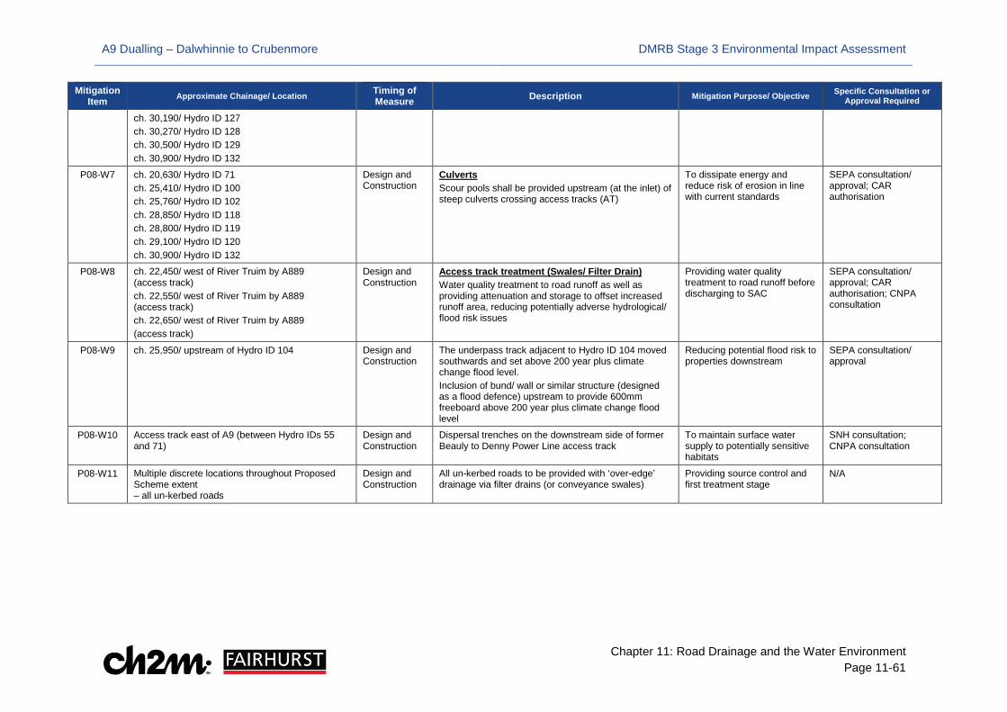
A9 Dualling – Dalwhinnie to Crubenmore DMRB Stage 3 Environmental Impact Assessment
Chapter 11: Road Drainage and the Water Environment Page 11-61
Mitigation Item Approximate Chainage/ Location Timing of
Measure Description Mitigation Purpose/ Objective Specific Consultation or Approval Required
ch. 30,190/ Hydro ID 127 ch. 30,270/ Hydro ID 128 ch. 30,500/ Hydro ID 129 ch. 30,900/ Hydro ID 132
P08-W7 ch. 20,630/ Hydro ID 71 ch. 25,410/ Hydro ID 100 ch. 25,760/ Hydro ID 102 ch. 28,850/ Hydro ID 118 ch. 28,800/ Hydro ID 119 ch. 29,100/ Hydro ID 120 ch. 30,900/ Hydro ID 132
Design and Construction
Culverts Scour pools shall be provided upstream (at the inlet) of steep culverts crossing access tracks (AT)
To dissipate energy and reduce risk of erosion in line with current standards
SEPA consultation/ approval; CAR authorisation
P08-W8 ch. 22,450/ west of River Truim by A889 (access track) ch. 22,550/ west of River Truim by A889 (access track) ch. 22,650/ west of River Truim by A889 (access track)
Design and Construction
Access track treatment (Swales/ Filter Drain) Water quality treatment to road runoff as well as providing attenuation and storage to offset increased runoff area, reducing potentially adverse hydrological/ flood risk issues
Providing water quality treatment to road runoff before discharging to SAC
SEPA consultation/ approval; CAR authorisation; CNPA consultation
P08-W9 ch. 25,950/ upstream of Hydro ID 104 Design and Construction
The underpass track adjacent to Hydro ID 104 moved southwards and set above 200 year plus climate change flood level. Inclusion of bund/ wall or similar structure (designed as a flood defence) upstream to provide 600mm freeboard above 200 year plus climate change flood level
Reducing potential flood risk to properties downstream
SEPA consultation/ approval
P08-W10 Access track east of A9 (between Hydro IDs 55 and 71)
Design and Construction
Dispersal trenches on the downstream side of former Beauly to Denny Power Line access track
To maintain surface water supply to potentially sensitive habitats
SNH consultation; CNPA consultation
P08-W11 Multiple discrete locations throughout Proposed Scheme extent – all un-kerbed roads
Design and Construction
All un-kerbed roads to be provided with ‘over-edge’ drainage via filter drains (or conveyance swales)
Providing source control and first treatment stage
N/A

A9 Dualling – Dalwhinnie to Crubenmore DMRB Stage 3 Environmental Impact Assessment
Chapter 11: Road Drainage and the Water Environment Page 11-62
Table 11-12: Project-Specific Additional Mitigation Commitments for Protection of the Water Environment
Mitigation Item Approximate Chainage/ Location Timing of Measure Description Mitigation Purpose/ Objective Specific Consultation or
Approval Required
Project-Specific Mitigation
P08-W12 ch. 20,750 at Hydro ID 72 ch. 21,450 at Hydro ID 77 ch. 22,250 at Hydro ID 82 ch. 26,050 at Hydro ID 104 ch. 29,200 at Hydro ID 121
Design and Construction Structures Contractor should evaluate potential of setting back abutments further from river banks to limit amount of erosion and scour protection required by carrying out detailed environmental and engineering assessments during detailed design
Allow natural migration/ evolution of river morphology, allow natural channel migration and encourage sediment transfer through the catchment without compromising structural integrity
CAR authorisation
P08-W13
ch.22,050/ south (approx. 30m) of unnamed watercourse W8.7/ hydro ID 81 (east of A9)
Design and Construction
Sheep Hardstanding A constructed farm wetland (CFW), or similar, to be included in the design adjacent to the sheep hardstanding
Wetland will receive and treat lightly contaminated surface water runoff from hardstanding, in such a manner that any discharge from the wetland will not pollute the water environment
SEPA consultation/ approval
P08-W14 All watercourse diversions throughout the Project 8 Proposed Scheme extent
Design and Construction Watercourse diversions Ensure natural channel dimensions are maintained. All watercourse diversions are to have a “low flow” channel, design to accommodation the 1:2 year flows on a site by site basis. Create channel with diverse bed and bank morphology suitable for bed slope to create a more stable channel
To maintain a minimal depth of flow and to allow for natural process and stability of new channels
CAR authorisation
P08-W15 Allt Garbh (ch. 29,150/ Hydro ID 121) Design and Construction Alter long profile create more stable step-pool or cascade morphology in order to remove the need for gabion mattress and banks; Provision of low flow channel under bridge; (designed to take the 1:2 year flow and reinstate channel width; Ensure continued transfer of natural bed sediments
Improve stability of channels and protect road bridge from ongoing current erosion due to unstable gabion structure; Reduce risk of damage to bridge; Reduce excessive sediment supply downstream; Mimic natural sediment regime/ morphological conditions and encourage establishment of more natural sediment transfer/ processes
CAR authorisation
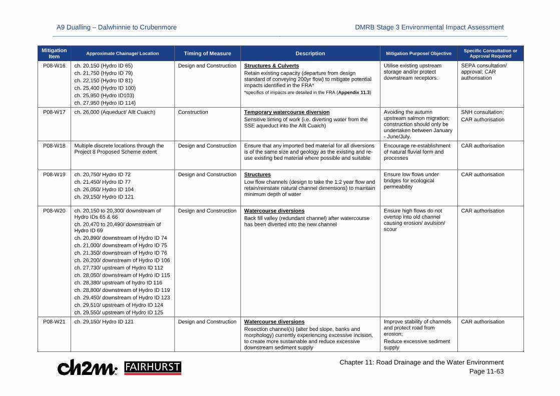
A9 Dualling – Dalwhinnie to Crubenmore DMRB Stage 3 Environmental Impact Assessment
Chapter 11: Road Drainage and the Water Environment Page 11-63
Mitigation Item Approximate Chainage/ Location Timing of Measure Description Mitigation Purpose/ Objective Specific Consultation or
Approval Required
P08-W16 ch. 20,150 (Hydro ID 65) ch. 21,750 (Hydro ID 79) ch. 22,150 (Hydro ID 81) ch. 25,400 (Hydro ID 100) ch. 25,950 (Hydro ID103) ch. 27,950 (Hydro ID 114)
Design and Construction Structures & Culverts Retain existing capacity (departure from design standard of conveying 200yr flow) to mitigate potential impacts identified in the FRA* *specifics of impacts are detailed in the FRA (Appendix 11.3)
Utilise existing upstream storage and/or protect downstream receptors.
SEPA consultation/ approval; CAR authorisation
P08-W17 ch. 26,000 (Aqueduct/ Allt Cuaich) Construction Temporary watercourse diversion Sensitive timing of work (i.e. diverting water from the SSE aqueduct into the Allt Cuaich)
Avoiding the autumn upstream salmon migration; construction should only be undertaken between January - June/July.
SNH consultation; CAR authorisation
P08-W18 Multiple discrete locations through the Project 8 Proposed Scheme extent
Design and Construction Ensure that any imported bed material for all diversions is of the same size and geology as the existing and re-use existing bed material where possible and suitable
Encourage re-establishment of natural fluvial form and processes
CAR authorisation
P08-W19 ch. 20,750/ Hydro ID 72 ch. 21,450/ Hydro ID 77 ch. 26,050/ Hydro ID 104 ch. 29,150/ Hydro ID 121
Design and Construction Structures Low flow channels (design to take the 1:2 year flow and retain/reinstate natural channel dimensions) to maintain minimum depth of water
Ensure low flows under bridges for ecological permeability
CAR authorisation
P08-W20
ch. 20,150 to 20,300/ downstream of Hydro IDs 65 & 66 ch. 20,470 to 20,490/ downstream of Hydro ID 69 ch. 20,890/ downstream of Hydro ID 74 ch. 21,000/ downstream of Hydro ID 75 ch. 21,350/ downstream of Hydro ID 76 ch. 26,200/ downstream of Hydro ID 106 ch. 27,730/ upstream of Hydro ID 112 ch. 28,050/ downstream of Hydro ID 115 ch. 28,380/ upstream of hydro ID 116 ch. 28,800/ downstream of Hydro ID 119 ch. 29,450/ downstream of Hydro ID 123 ch. 29,510/ upstream of Hydro ID 124 ch. 29,550/ upstream of Hydro ID 125
Design and Construction
Watercourse diversions Back fill valley (redundant channel) after watercourse has been diverted into the new channel
Ensure high flows do not overtop into old channel causing erosion/ avulsion/ scour
CAR authorisation
P08-W21 ch. 29,150/ Hydro ID 121 Design and Construction Watercourse diversions Resection channel(s) (alter bed slope, banks and morphology) currently experiencing excessive incision, to create more sustainable and reduce excessive downstream sediment supply
Improve stability of channels and protect road from erosion; Reduce excessive sediment supply
CAR authorisation

A9 Dualling – Dalwhinnie to Crubenmore DMRB Stage 3 Environmental Impact Assessment
Chapter 11: Road Drainage and the Water Environment Page 11-64
Mitigation Item Approximate Chainage/ Location Timing of Measure Description Mitigation Purpose/ Objective Specific Consultation or
Approval Required
P08-W22 ch. 20,775/ upstream of Hydro ID 72 ch. 25,925/ upstream of Hydro ID 104 ch. 25,930/ upstream of Hydro ID 104 ch. 27,450/ upstream of Hydro ID 111 ch. 29,350/ downstream of Hydro ID 121 ch. 30,800/ downstream of Hydro 130 ch. 30,825/ downstream of Hydro 130 ch. 30,875/ downstream of Hydro 130 ch. 30,925/ downstream of Hydro 130
Design and Construction
Drainage channel Outfall at risk of erosion, therefore, design outfall using green engineering to allow for channel adjustment in receiver channel (change in bed and bank position); Low velocity outfall
Reduce potential scour/ erosion around drainage outfalls due to alterations in fluvial processes. Ensure integrity of structure is not compromised and remain operational.
CAR authorisation; CNPA consultation
P08-W23
All culverts throughout the Project 8 Proposed Scheme extent
Design and Construction Culverts All culverts are to have a “low flow” channel, design to accommodation the 1:2 year flow on a site by site basis
To maintain a minimal depth of flow and to allow for natural process and stability through culvert
SEPA consultation/ approval; CAR authorisation
P08-W24
All watercourse diversions throughout the Project 8 Proposed Scheme extent
Design and Construction Channel material All material that is to be placed within the channel (realignment, structure, culvert) should be specified (i.e. grain size and composition) and clearly justified. The calibre and quantity of material should be determined on a site by site basis and this should take into account changes in the energy regime within the river.
To allow the ongoing downstream transfer of sediment
CAR authorisation
P08-W25
All culverts throughout the Project 8 Proposed Scheme extent
Design and Construction Culverts All culverts are to have a scour pool at the outlet
Dissipate energy and reduce risk of scour to structures
SEPA consultation/ approval; CAR authorisation
P08-W26
All culverts throughout the Project 8 Proposed Scheme extent
Design and Construction Culverts Identify and design energy dissipation in culverts on a site by site basis. This could take the form of step-pool like structures, which will also aid in retention of bed material.
Dissipate energy and reduce risk of scour to structures. Aid with sediment retention in culvert.
SEPA consultation/ approval; CAR authorisation
P08-W27 Multiple discrete locations through the Project 8 Proposed Scheme extent
Design, Construction and Post-construction/ Operation
Riparian planting Awareness of flood risk should be taken into account when selecting species for riparian planting in the circa 5m buffer along watercourse channel banks
Avoid potential blockage of downstream crossings from large vegetation species (i.e. fallen trees and branches)
CNPA consultation
A9 Dualling – Dalwhinnie to Crubenmore DMRB Stage 3 Environmental Impact Assessment
Chapter 11: Road Drainage and the Water Environment Page 11-65
11.6 Residual Impacts
11.6.1 Following implementation of the additional specific mitigation outlined in section 11.5, potential impacts on the water environment will be avoided/ prevented, reduced or offset. The vast majority of residual impacts would be reduced to Neutral significance, due to the adoption of appropriate additional mitigation measures. For example, a Neutral significance for flood risk has been achieved with the provision of compensatory storage areas (based on a level-for-level volume-slices approach) designed to offset the loss of functional floodplain from encroachment of mainline, access tracks and SuDS. The remaining residual impacts that would not be of Neutral significance (beneficial and adverse) are presented in Table 11-13.
11.6.2 Recommendations for periodic monitoring are also reported where relevant in the appropriate appendices. The purpose of monitoring (in line with EIA Directive) is to ensure the effectiveness of mitigation measures on any significant (adverse) impacts on the environment resulting from the construction and operation of the Proposed Scheme. Monitoring will also identify unforeseen significant adverse impacts in order to undertake appropriate remedial action.
Water Quality
11.6.3 As the existing drainage system considerably predates the employment of SuDS techniques (and any treatment currently provided is at best incidental and does not meet the requirements of current standards) there is no facility anywhere on the existing drainage system to intercept and contain accidental spillages of oil or other contaminants. Therefore, an overall improvement in water quality is predicted compared with the baseline condition due to the first-time application of SuDS resulting in a residual Slight Beneficial impact.
Hydrology
11.6.4 As the majority of watercourses which will have alterations to their catchment sizes are little more than heavily engineered road drainage channels draining boggy flat land, potential impact is not deemed to be detrimental to the River Truim (as part of the Spey SAC). The diverted waters ultimately discharge to the River Truim (via tributaries or directly to the main channel) and therefore, no loss of water from the catchment is envisaged. Allt Coire Bhathaich (MW8.8/ Hydro ID 82) contributes to the SSE Tummel Hydropower Scheme; however, the scheme will not be compromised as water is not being diverted out of the catchment and does not adversely impact on SSE operations. Therefore, a Neutral residual impact is determined.
Flood Risk
11.6.5 The inclusion of SuDS in the Proposed Scheme design provides attenuation to greenfield runoff rates across the Project extent; and despite the dualled carriageway increasing potential surface runoff, the absence of existing attenuation means the Proposed Scheme will result in an overall improvement on the water environment resulting in a residual Slight Beneficial impact.
11.6.6 The flood modelling results indicate that a section of the A9 (ch. 20,350 to 20,750) is currently at risk of overtopping and flooding the road in a 200 year event from watercourse W8.38/ Hydro ID 67. The Proposed Scheme removes this flood risk; therefore, as the watercourse is assigned a Very High sensitivity (due to the potential flood risk it poses to critical infrastructure i.e. the A9), and the magnitude of impact is deemed Minor Beneficial, the overall significance of impact is Large Beneficial.
A9 Dualling – Dalwhinnie to Crubenmore DMRB Stage 3 Environmental Impact Assessment
Chapter 11: Road Drainage and the Water Environment Page 11-66
11.6.7 Hydraulic modelling indicates a loss of flood storage volume due to mainline encroachment into the functional floodplain upstream of Hydro ID 81 (W8.7). In accordance with SEPA and SPP guidelines, a compensatory storage area has been incorporated into the design to offset this loss. However, due to other spatial and environmental constraints, full compensation is unachievable. Therefore, a further measure to fully mitigate the lost volume is proposed in Appendix 11.3 and section 11.5; specifically, maintaining existing capacity at Hydro ID 81 in order to mobilise natural floodplain upstream of the crossing.
11.6.8 This proposed mitigation measure will raise flood levels by approximately 0.23m, extending the floodplain by 2 to 5m out from the Proposed Scheme extent. As water feature W8.7 has a High sensitivity value for flood risk due to potential impact on the road, an overall Large Adverse significance of impact would be determined using criteria set out in section 11.2. However, the land affected by this mobilisation of floodplain is rough grazing and classed as Low sensitivity; therefore, a residual Slight Adverse impact has been assigned.
11.6.9 The predicted 320mm increase in flood levels immediately upstream of the Allt Cuaich crossing (MW8.14/ Hydro ID 104) adjacent to the A9 is not offset with the provision of a CSA. Hydraulic modelling has shown that the CSA is ineffective and was therefore, removed from the design (details are provided in Appendix 11.3). A potential flow route through an adjacent underpass to downstream properties in Cuaich has been identified; therefore, alternative mitigation has been proposed. This includes raising the level of the track at the underpass above the 200 year plus climate change flood level and adding a bund/ wall or similar structure (designed as a flood defence) to provide a 600mm freeboard. Appendix 11.3 has identified an increase in flood risk downstream. Additional mitigation has been proposed to offset this; specifically, reducing the capacity of culvert crossing Hydro 103 to reduce conveyance of flood waters downstream.
11.6.10 The proposed mitigation measures outlined above will increase peak flood waters by 320mm on the upstream side of the A9 on land identified as suitable for rough grazing. Using criteria set out in section 11.2, Allt Cuaich has been assigned a Very High sensitivity for flood risk as it currently poses a risk to the existing A9, deemed as critical infrastructure, and residential properties; however, rough grazing is classed as a Low sensitivity. Therefore, as the Proposed Scheme has built-in flood resilience and the elevated road levels are 4m above peak flood water levels and not directly impacted in a 200-year event, and as protection of residential properties will take precedence over rough grazing land, a residual Slight Adverse impact has been assigned.
Hydromorphology
11.6.11 Implementation of additional mitigation to ensure varied bed and bank profiles for realignment channels of watercourse 65, 111, and 112 would result in residual Slight Beneficial impacts. Details are provided in Appendix 11.4.
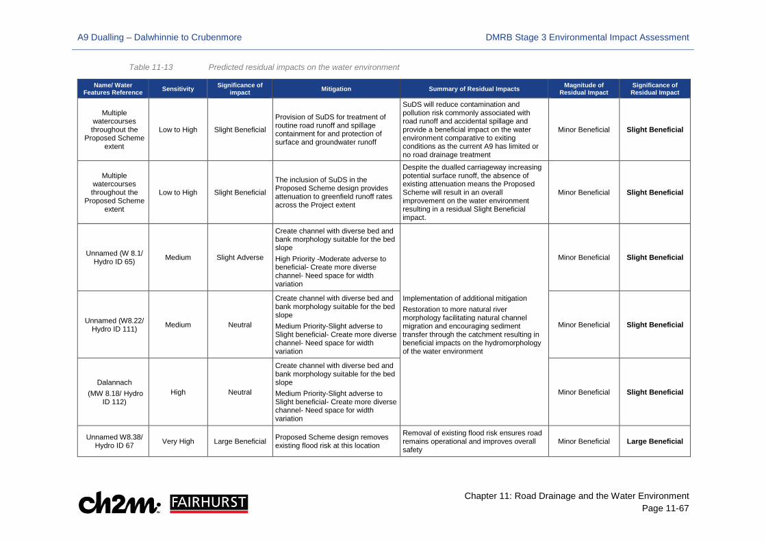
A9 Dualling – Dalwhinnie to Crubenmore DMRB Stage 3 Environmental Impact Assessment
Chapter 11: Road Drainage and the Water Environment Page 11-67
Table 11-13 Predicted residual impacts on the water environment
Name/ Water Features Reference Sensitivity Significance of
impact Mitigation Summary of Residual Impacts Magnitude of Residual Impact
Significance of Residual Impact
Multiple watercourses throughout the
Proposed Scheme extent
Low to High Slight Beneficial Provision of SuDS for treatment of routine road runoff and spillage containment for and protection of surface and groundwater runoff
SuDS will reduce contamination and pollution risk commonly associated with road runoff and accidental spillage and provide a beneficial impact on the water environment comparative to exiting conditions as the current A9 has limited or no road drainage treatment
Minor Beneficial Slight Beneficial
Multiple watercourses throughout the
Proposed Scheme extent
Low to High Slight Beneficial The inclusion of SuDS in the Proposed Scheme design provides attenuation to greenfield runoff rates across the Project extent
Despite the dualled carriageway increasing potential surface runoff, the absence of existing attenuation means the Proposed Scheme will result in an overall improvement on the water environment resulting in a residual Slight Beneficial impact.
Minor Beneficial Slight Beneficial
Unnamed (W 8.1/ Hydro ID 65) Medium Slight Adverse
Create channel with diverse bed and bank morphology suitable for the bed slope High Priority -Moderate adverse to beneficial- Create more diverse channel- Need space for width variation
Implementation of additional mitigation Restoration to more natural river morphology facilitating natural channel migration and encouraging sediment transfer through the catchment resulting in beneficial impacts on the hydromorphology of the water environment
Minor Beneficial Slight Beneficial
Unnamed (W8.22/ Hydro ID 111) Medium Neutral
Create channel with diverse bed and bank morphology suitable for the bed slope Medium Priority-Slight adverse to Slight beneficial- Create more diverse channel- Need space for width variation
Minor Beneficial Slight Beneficial
Dalannach (MW 8.18/ Hydro
ID 112) High Neutral
Create channel with diverse bed and bank morphology suitable for the bed slope Medium Priority-Slight adverse to Slight beneficial- Create more diverse channel- Need space for width variation
Minor Beneficial Slight Beneficial
Unnamed W8.38/ Hydro ID 67 Very High Large Beneficial Proposed Scheme design removes
existing flood risk at this location
Removal of existing flood risk ensures road remains operational and improves overall safety
Minor Beneficial Large Beneficial
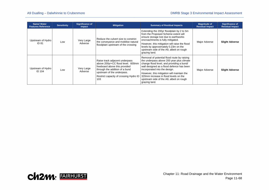
A9 Dualling – Dalwhinnie to Crubenmore DMRB Stage 3 Environmental Impact Assessment
Chapter 11: Road Drainage and the Water Environment Page 11-68
Name/ Water Features Reference Sensitivity Significance of
impact Mitigation Summary of Residual Impacts Magnitude of Residual Impact
Significance of Residual Impact
Upstream of Hydro ID 81 Low Very Large
Adverse
Reduce the culvert size to constrict the conveyance and mobilise natural floodplain upstream of the crossing
Extending the 200yr floodplain by 2 to 5m from the Proposed Scheme extent will ensure storage lost due to earthworks encroachments is fully mitigated. However, this mitigation will raise the flood levels by approximately 0.23m on the upstream side of the A9, albeit on rough grazing land.
Major Adverse Slight Adverse
Upstream of Hydro ID 104 Low Very Large
Adverse
Raise track adjacent underpass above 200yr+CC flood level. 600mm freeboard above this provided through the addition of a bund upstream of the underpass. Restrict capacity of crossing Hydro ID 103
Removal of potential flood route by raising the underpass above 200 year plus climate change flood level, and providing a bund/ wall designed as a flood defence has been incorporated into the design. However, this mitigation will maintain the 320mm increase in flood levels on the upstream side of the A9, albeit on rough grazing land.
Major Adverse Slight Adverse
A9 Dualling – Dalwhinnie to Crubenmore DMRB Stage 3 Environmental Impact Assessment
Chapter 11: Road Drainage and the Water Environment Page 11-69
11.7 Summary of Combined Impacts
11.7.1 Combined impacts are provided in this section in order to demonstrate that there are no adverse impacts to the water environment as per DMRB HD45/09 and Scottish Planning Policy and SEPA guidance. Combined impacts are also considered relevant to WFD status (i.e. cumulative impact can downgrade classification of a water body) hence CAR requires wider consideration of multiple activities on a single project or multiple projects on a single water body.
Water Quality
11.7.2 The HAWRAT assessment requires that any two outfalls situated within the same reach are subject to a cumulative assessment. In line with DMRB HD45/09, a precautionary approach has been adopted when aggregating outfalls for the cumulative impact assessment. Soluble pollutants have been assessed where numerous outfalls are within a 1km reach of a receiving watercourse (for the purpose of this report, a reach is defined as a length of watercourse between two confluences). For sediment bound pollutants, outfalls within a 100m reach have been aggregated.
11.7.3 No cumulative impacts were found to fail the HAWRAT assessment after implementation of mitigation, (i.e. that which has been incorporated into the Proposed Scheme design, which results in a Neutral cumulative impact. Details of the assessment are provided in Appendix 11.2.
Hydrology and Flood Risk
Existing conditions and the Proposed Scheme have been hydraulically modelled. Minimal changes in water levels were found to occur at the downstream section of the Project 8 extent. The cumulative model indicates an increase of 3mm at the downstream section of Project 8. Overall, this is considered to be a Neutral significance. Analysis at key sensitive receptors throughout the Project also found minor or negligible changes in water levels which results in a Neutral cumulative impact. Details of the assessment are provided in Appendix 11.3.
Hydromorphology
11.7.4 There will be multiple small changes to sediment transfer, discharge and velocity within the tributaries that flow into the River Truim. These have the potential to have a positive impact on the form and processes of the larger downstream watercourses and the wider catchment over long timescales by returning flows and sediment supply to more natural pre A9 conditions.
11.7.5 Many of the proposed works (increasing culvert capacity, providing a natural bed within culverts and under bridges and removing catchpits) will increase discharge capacity and potential volume of sediment conveyed from the tributaries to the Truim, creating more natural conditions by returning the systems to something closer to those that were present before the A9 was originally constructed. This will have a Slight Beneficial cumulative impact on the hydromorphology of the River Truim and tributaries. Details of the assessment are provided in Appendix 11.4

A9 Dualling – Dalwhinnie to Crubenmore DMRB Stage 3 Environmental Impact Assessment
Chapter 11: Road Drainage and the Water Environment Page 11-70
11.8 References
British Geological Survey (2011). User Guide: Groundwater Vulnerability (Scotland) GIS Dataset, Version 2. Available at http://nora.nerc.ac.uk/17084/1/OR11064.pdf
British Geological Survey (2015). Geology of Britain Viewer. Available at http://mapapps.bgs.ac.uk/geologyofbritain/home.html
Cairngorms National Park (2013). Cairngorms National Park Proposed Local Development Plan. http://cairngorms.co.uk/resource/docs/publications/12042013/CNPA.Paper.1880.Proposed%20Local%20Development%20Plan.pdf
Cairngorms National Park (2013). Cairngorms National Park Proposed Local Development Plan - Supplementary Guidance. Available at http://cairngorms.co.uk/resource/docs/publications/12042013/CNPA.Paper.1881.PLDP%20Supplementary%20Guidance.pdf
Centre for Ecology and Hydrology (1999). Flood Estimation Handbook
Centre for Ecology and Hydrology (2015). Hydrological Data. Available at http://www.ceh.ac.uk/data
CIRIA (1994). Control of Pollution from Highway Drainage Discharges - C142
CIRIA (2004). Sustainable drainage systems – C609
CIRIA (2004). Sustainable Drainage Systems, Hydraulic, Structural and Water Quality Advice
CIRIA (2006). Control of Water Pollution from Linear Construction Projects, Technical Guide C648
CIRIA (2015). The SUDS Manual – C753
CIRIA (2010). Culvert Design and Operation Guide - C689
Cuthbertson & Partners (1990). Flooding in Badenoch and Strathspey. Final Report Volume 1
Department of Environment Food and Rural Affairs (2003). Guidebook of Applied Fluvial Geomorphology. R&D Technical Report TD1914
Environment Agency (2009). The Fluvial Design Guide. Available at https://www.gov.uk/government/publications/fluvial-design-guide
European Union Water Framework Directive 2000/60/EC. Available at http://eur-lex.europa.eu/legal-content/EN/TXT/?uri=CELEX:32000L0060
European Union Floods Directive 2007/60/EC. Available at http://eur-lex.europa.eu/legal-content/EN/TXT/?uri=CELEX:32007L0060
European Union Groundwater Directive 2006/118/EC. Available at http://eur-lex.europa.eu/LexUriServ/LexUriServ.do?uri=OJ:L:2006:372:0019:0031:EN:PDF
European Union Priority Substances Directive 2008/105/EC. Available at http://ec.europa.eu/environment/water/water-dangersub/pri_substances.htm
European Union Environmental Impact Assessment Directive 2014/52/EU. Available at http://eur-lex.europa.eu/legal-content/EN/TXT/?uri=celex:32014L0052
Flood Risk Management (Scotland) Act 2009. Available at http://www.legislation.gov.uk/asp/2009/6/pdfs/asp_20090006_en.pdf
Gemmell, S. L. G., Hansom, J. D., Hoey, T. B., (2001). The geomorphology, conservation and management of the River Spey and Spey Bay SSSIs Moray. Scottish Natural Heritage Research and Monitoring Report No. 57
Gilvear (2004). Patterns of channel adjustment to impoundment of the upper River Spey Scotland 1942–2000
A9 Dualling – Dalwhinnie to Crubenmore DMRB Stage 3 Environmental Impact Assessment
Chapter 11: Road Drainage and the Water Environment Page 11-71
Gregory, K. J., (1997). Introduction to the fluvial geomorphology of Great Britain. In (ed.) Gregory, K. J., Fluvial Geomorphology of Great Britain, Chapman & Hall, London
Grieve, I. C., Gilvear, D. G., Bryant, R. G. (1995). Hydrochemical and water source variations across a floodplain mire, Insh Marshes, Scotland. Hydrological Processes 9(1), pp. 99-110
Halcrow/ CH2MHill (2013). A9 Dualling Programme – Strategic Flood Risk Assessment. Document No. TSSEA9/SFRA/03. Transport Scotland
Haycocks Associates (2005). Review of Impact Assessment Tool and Post Project Monitoring Guidance. Available at http://www.sepa.org.uk/media/152207/wat_sg_30.pdf
Highways Agency (1993). DMRB Volume 5, Section 1, Part 2 (TD37/93) Scheme Assessment Reporting. Available at http://www.standardsforhighways.co.uk/dmrb/vol5/section1/td3793.pdf
Highways Agency (2004). DMRB Volume 4, Section 2, Part 7 (HA107/04) Design of Outfall and Culvert Details. Available at http://www.standardsforhighways.co.uk/dmrb/vol4/section2/ha10704.pdf
Highways Agency (2006). DMRB Volume 4, Section 2, Part 1 (HA103/06) Vegetated Drainage Systems for Highway Runoff. Available at http://www.standardsforhighways.co.uk/dmrb/vol4/section2/ha10306.pdf
Highways Agency (2006). DMRB Volume 4, Section 2, Part 3 (HA33/06) Surface and Sub-surface Drainage systems for Highways. Available at http://www.standardsforhighways.co.uk/dmrb/vol4/section2/hd3306.pdf
Highways Agency (2009). DMRB Volume 11, Section 3, Part 10 (HD45/09) Road Drainage and the Water Environment. Available at http://www.standardsforhighways.co.uk/dmrb/vol11/section3/hd4509.pdf
Highway Agency (2015) Highways Agency Water Risk Assessment Tool (HAWRAT) (excel programme). Available at http://www.haddms.com/
Hinxman L. W., (1901). The River Spey. Scottish Geographical Magazine, 17:4, pp. 185-193
HR Wallingford (1983). Design and Analysis of Urban Storm Drainage. Volume 4 Modified Rational Method
HR Wallingford (2001). Manual of River Restoration Techniques. Available at http://www.therrc.co.uk/manual-river-restoration-techniques
HR Wallingford (2002). River Diversions - A Design Guide
Institute of Hydrology (1980). Low Flow Studies Report No 2.1 - Flow Duration Curve Estimation Manual. Available at http://nora.nerc.ac.uk/9094/1/Low_Flow_21.pdf
Institute of Hydrology (1980). Low Flow Studies Report No 2.2 - Flow Frequency Curve Estimation Manual. Available at http://nora.nerc.ac.uk/9095/1/Low_Flow_22.pdf
Institute of Hydrology (1994). Report No. 124 Flood estimation for small catchments
Landmark Information Group (2012). Envirocheck Report – Dalwhinnie and Crubenmore-Kingussie. 42777641_1_1. 22nd November 2012
National Library of Scotland (2015). Maps. Available at http://maps.nls.uk/ https://www.old-maps.co.uk/#/
River Spey Catchment Steering Group (2016). River Spey Catchment Management Plan. Available at http://www.speyfisheryboard.com/wp-content/uploads/2016/12/SCI-2016-Catchment-Management-Plan.pdf
Royal Commission on the Ancient and Historical Monuments of Scotland (RCAHMS) (2015). National Collection of Aerial Photography. Available at http://ncap.org.uk/
Royal Society for the Protection of Birds (2015). Open Source Reports. Available at http://www.rspb.org.uk/
Scottish Government (2001). Planning Advice Note 61. Available at http://www.gov.scot/Publications/2001/07/pan61

A9 Dualling – Dalwhinnie to Crubenmore DMRB Stage 3 Environmental Impact Assessment
Chapter 11: Road Drainage and the Water Environment Page 11-72
Scottish Government (2012). River Crossings and Migratory Fish: Design Guidance. Available at http://www.gov.scot/Topics/marine/science/Publications/publicationslatest/rivercrossings
Scottish Government (2014). Scottish Planning Policy. Available at http://www.gov.scot/Publications/2014/06/5823
Scottish Natural Heritage (1997). Rivers and their catchments: channel form and processes - Information and Advisory Note Number 79. Available at http://www.snh.org.uk/publications/on-line/advisorynotes/79/79.html
Scottish Natural Heritage (2015). Publications, data and Research. Available at http://www.snh.gov.uk/publications-data-and-research/
Scotland’s Soils (2015). 1:250,000 Soil Map. Available at http://www.soils-scotland.gov.uk/data/soil-survey
SEPA (2006). Special Requirements for Civil Engineering Contracts for the Prevention of Pollution (WAT-SG-31). Available at http://www.sepa.org.uk/media/152220/wat_sg_31.pdf
SEPA (2006). Guidance on the Special Requirements for Civil Engineering Contracts (WAT-SG-32). Available at http://www.sepa.org.uk/media/152233/wat_sg_32.pdf
SEPA (2008). Engineering in the Water Environment: Good Practice Guide, Intakes and outfalls (WAT-SG-28). Available at https://www.sepa.org.uk/media/150984/wat_sg_28.pdf
SEPA (2008). Constructed Farm Wetlands (CFW) Design Manual for Scotland and Northern Ireland, Prepared for the Northern Ireland Environment Agency and the Scottish Environment Protection Agency. Available at https://www.sepa.org.uk/media/131412/constructed-farm-wetlands-manual.pdf
SEPA (2009). Engineering in the Water Environment: Good Practice Guide, River Crossings Second Edition (WAT-SG-25). Available at https://www.sepa.org.uk/media/151036/wat-sg-25.pdf
SEPA (2009). Engineering in the Water Environment: Good Practice Guide, Temporary Construction Methods (WAT-SG-29). Available at http://www.sepa.org.uk/media/150997/wat_sg_29.pdf
SEPA (2011). Environmental Standards for River Morphology (WAT-SG-21). Available at https://www.sepa.org.uk/media/152194/wat_sg_21.pdf
SEPA (2014). Dalwhinnie – Potentially Vulnerable Area 05/14. Available at https://frm-scotland.org.uk/frmp/findhorn-nairn-and-speyside-lpd-5-draft-flood-risk/user_uploads/05_14-pva-v3.0.pdf
SEPA (2014). Land Use Planning System Guidance Note 31. Available at http://www.sepa.org.uk/media/143868/lupsgu31_planning_guidance_on_groundwater_abstractions.pdf
SEPA (2017). Regulatory Method (WAT-RM-08) Sustainable Urban Drainage Systems. Available at http://www.sepa.org.uk/media/152740/wat_rm_08.pdf
SEPA (2014). Supporting Guidance (WAT-SG-53) Environmental Quality Standards. Available at http://www.sepa.org.uk/media/28319/at-sg-53_environmental-standards-for-discharges-to-surface-waters.pdf
SEPA (2015). Flood Maps. Available at http://map.sepa.org.uk/floodmap/map.htm
SEPA (2015). River Basin Management Plan Interactive Map. Available at http://gis.sepa.org.uk/rbmp/
SEPA (2015). Technical Flood Risk Guidance for Stakeholders. Available at http://www.sepa.org.uk/media/143442/ss-nfr-p-002-technical-flood-risk-guidance-for-stakeholders.pdf
SEPA (2015). Assessing the Significance of Impacts - Social, Economic, Environmental (WAT-SG-67). Available at
https://www.sepa.org.uk/media/149801/wat_sg_67.pdf
Spey Fishery Board (2015). Catchment Characteristics. Available at http://www.speyfisheryboard.com/catchment-characteristics/

A9 Dualling – Dalwhinnie to Crubenmore DMRB Stage 3 Environmental Impact Assessment
Chapter 11: Road Drainage and the Water Environment Page 11-73
SNIFFER (2009). WFD95: A Function Wetland Typology for Scotland. Available at http://www.sniffer.org.uk/files/7213/4183/8004/SnifferWFD95_FinalProjectReport.pdf
The Highland Council (2012). Highland Wide Local Development Plan. Available at http://www.highland.gov.uk/downloads/file/1505/highland-wide_local_development_plan
The Highland Council (2013). Supplementary Guidance.http://www.highland.gov.uk/info/178/local_and_statutory_development_plans/213/supplementary_guidance
The Water Environment and Water Services (Scotland) Act 2003. Available at http://www.legislation.gov.uk/asp/2003/3/pdfs/asp_20030003_en.pdf
The Water Environment (Controlled Activities) (Scotland) Regulations 2011. Available at http://www.sepa.org.uk/media/34761/car_a_practical_guide.pdf
The Water Environment (Groundwater and Priority Substances) (Scotland) Regulations 2009. Available at http://www.legislation.gov.uk/ssi/2009/420/pdfs/ssi_20090420_en.pdf
The Water Environment (River Basin Management Planning: Further provision) (Scotland) Regulations 2013. Available at http://faolex.fao.org/docs/pdf/uk128912.pdf
Werritty, A., Ferguson, R. I., (1980). Pattern changes in a Scottish braided river over 1, 30, and 200 years. In (eds.) Cullingford, R. A., Davidson, D. A., Lewin, J., Timescales in Geomorphology, John Wiley & Sons, Chichester
Werritty, A., Hoey, T. B., Black, A. R. (2005). The geomorphology and management of a dynamic, unstable gravel-bed river: the Feshie-Spey confluence, Scotland. Developments in Earth Surface Processes 7, pp. 213-224
WSP (2009). SUDS for Roads. Available at http://scots.sharepoint.apptix.net/SuDS/General%20Publications/Forms/AllItems.aspx