1084-feature positioning on google street view panoramas
TRANSCRIPT

FEATURE POSITIONING ON GOOGLE STREET VIEW PANORAMAS
Victor J. D. Tsai and Chun-Ting Chang
Dept. of Civil Engineering, National Chung Hsing University, Taichung 40227, Taiwan - [email protected]
Commissions IV, II, VI, WG II/6, IV/5,4,1,8, II/6, VI/1,2
KEY WORDS: Google Maps API, Google Street View, 3D Positioning, Intersection, Points of Interest (POI) ABSTRACT: Location-based services (LBS) on web-based maps and images have come into real-time since Google launched its Street View imaging services in 2007. This research employs Google Maps API and Web Service, GAE for JAVA, AJAX, Proj4js, CSS and HTML in developing an internet platform for accessing the orientation parameters of Google Street View (GSV) panoramas in order to determine the three dimensional position of interest features that appear on two overlapping panoramas by geometric intersection. A pair of GSV panoramas was examined using known points located on the Library Building of National Chung Hsing University (NCHU) with the root-mean-squared errors of ±0.522m, ±1.230m, and ±5.779m for intersection and ±0.142m, ±1.558m, and ±5.733m for resection in X, Y, and h (elevation), respectively. Potential error sources in GSV positioning were analyzed and illustrated that the errors in Google provided GSV positional parameters dominate the errors in geometric intersection. The developed system is suitable for data collection in establishing LBS applications integrated with Google Maps and Google Earth in traffic sign and infrastructure inventory by adding automatic extraction and matching techniques for points of interest (POI) from GSV panoramas.
1. INTRODUCTION
The emerging development in microelectronic industry has raised the productivity and performance in mobile mapping devices and the demands in consequent value-added services. Among them the location-based services (LBS) on web-based maps and images have come into real-time since Google launched its Street View imaging services in 2007 (Vincent, 2007). GSV images were taken from a ring of eight cameras plus a fish-eye lens on top for producing the most popular 360-degree panoramic views (Anguelov et al., 2010). As shown in Figure 1, the 4th generation Street View car was equipped with a R5 system at a height of about 2.5 meters, Global Positioning Systems (GPS) units for vehicle positioning, three laser range scanners for the measuring distances of objects up to 50 meters 180° around the vehicle, and network antennas for scanning 3G/GSM and Wi-Fi hotspots. Each available GSV panorama can be requested in an HTTP URL form using Google Maps Application Programming Interface (Google Maps API), along with the projection type, the geodetic position of the Street View car and its moving direction with respect to the North at the time of image capture. Hence, it provides the user opportunities to determine the spatial position of features that appear on the GSV panoramas. This research employs Google Maps JavaScript API, Google App Engine (GAE) for JAVA, Asynchronous JavaScript And XML (AJAX), and Proj4js (Evenden, 2003) in developing an internet platform for accessing the orientation parameters of GSV panoramas in order to determine the geographic position of any interest features that appear on two overlapping images by intersection, and to determine the position of the exposure center of a panorama from at least three known control points by resection. Extracted 3D positional information of the features from intersection can be packed in Keyhole Markup Language (KML) format and stored in GAE Servlet for future LBS applications integrated with Google Maps and Google Earth. Key elements of the developed platform were introduced in the next section, followed by the results and error analyses from examining known points appeared on the GSV panoramas, and conclusions.
Figure 1. Devices adapted on the 4th generation GSV car (Center image edited from http://en.wikipedia.org/wiki/
File:Google_Street_View_car_Switzerland.jpg)
2. GOOGLE STREET VIEW AND MAPS API 2.1 Basics for Google Street View Panorama Though with composing techniques in veiled, a GSV panorama is a 360° surrounding image generated from mosaicking the eight original images captured by the eight horizontal cameras in the sequences as shown in Figure 2. The percentage of horizontal overlap between adjacent original images is about 28.8% for removing the most distorted outside portion of an original image caused by camera lens. Meanwhile, the panorama was aligned with the heading direction of the vehicle at the center. Each GSV panorama was tile-indexed in a 6 zoom-level image pyramid with the size of 416*208 pixels in level 0, with a scale factor of 2, to 13312*6656 in level 5 for covering the field of view of 360° in horizontal and 180° in vertical. Thus, it is convenient to convert the rectangular image coordinates (row, column) in the developed panorama plane into spherical coordinates (latitude, longitude), and vice versa, in the following equivalent as in the level 5 zooming image: pixelpixels oo /"35577.37'1013312/360 (1).
ISPRS Annals of the Photogrammetry, Remote Sensing and Spatial Information Sciences, Volume I-4, 2012 XXII ISPRS Congress, 25 August – 01 September 2012, Melbourne, Australia
305

(d) Exa
Figure 2. Coaccesse
streetvie 2.2 Parameter The coordinateaccessed fromlongitude in WgetLatLng() myaw in degreerespect to true method for camthe getPov() melevation (heigbe accessed byWeb Services.When being pfeature or poinand pitch attriangle and vertrespectively. Tor a specific tmay be a labelcoordinates acthe position of
3. 3.1 Coordinat The coordinatcoordinates (ellipsoid) in Transverse MGRS80 ellipso(ITRF) 1997 (Ezone 121 X-Y3828). The trasystems are ma
ample images (from
(e) Mosa
omposition of a ed from http://mew/technology/p
rs Accessed fro
es associated wm Google MapWGS84 referenmethod in Strees to true north,
north, can alsomera 1 in the P
method in Streetght from ellipsoy Google Eleva. pointed with thnt of interest (POibutes of the Sttical angle fromThe POI may betarget whose gled point alreadyccessed by Streef the initial poin
JavaScript I
te Systems and
tes used in the(latitude, longi
WGS84 ellMercator 2° zon
oid and InternaEPSG: 3826), a
Y coordinates bansformations aade convenient
m left: camera 5, 4,
aicked panorama
GSV Panoramamaps.google.com/photos-into-stre
om Google Ma
ith the GSV panps JavaScript Ace ellipsoid for
eetviewLocation, i.e., the car heo be requested bPov class, whichtviewLocation coid) of the initiation API unde
he mouse cursoOI) can be locatreetviewPov clm the horizon oe a commercial
global location y posted in the etviewLocationnt of view of a G
IMPLEMENT
d Transformat
e implementatiitude, elevatioipsoid (EPSG
ne 121 X-Y coational Terrestriand TWD67 Trabased on GRS6among these cofrom using Proj
3, 2, 1, 8, 7, 6)
a (Example imam/help/maps/ eet-view.html)
aps API
norama which cAPI are latituder its center usinn class. The caeading directionby using the getYh can be accessclass. Meanwhilial point of viewer Google Maps
or in a panoramted from the heass for its azimof the point of entity, a trafficto be determinGAE Servlet w class for compGSV panorama
TATION
tions
on include geoon or height G: 4326), TWoordinates baseial Reference Fansverse Merca67 ellipsoid (Eoordinate and d
oj4js (Evenden,
ages
can be e and ng the amera n with Yaw() sed by le, the w can s API
ma, a eading muthal
view, c sign, ned. It
with its puting a.
odetic from
WD97 ed on Frame ator 2° EPSG: datum 2003;
Proj4param 3.2 I As sh3D rstatioGSVMapthe cexporespeapply& W
X
Y
Z
wher
F
3.3 R In a Glocat(azimlabelMapComresecinteris tak
4js Track andmeters (OGP G
Intersection
hown in Figure rectangular cooons with angul
V panoramas, ws API as descri
coordinates of aosure centersectively. The cying intersectio
Wolf, 2006, 2008
c
)( RL
P
YYX
c
( LR
P
XXY
*LP
LPZZ
re
tan 1
XRP
XLP
LR
LR
LR
P
P
C: a constalies with re
LP , RP :
LP , RP :
the left cen
Figure 3. Concep
Resection
GSV panoramate the exposure muthal angles) led points withs API from the
mputational proction can be foursection, the aveken for the elev
Wiki, 2012) Geomatics, 2012
3, computationordinate systemlar observationwhose parametibed in Sectiona POI, and (X, for the left aoordinates of tn of two lines w
8) using coordin
cotcot
cot
RL XX
cotcot
cot)
RL YY
2
tan* RLP Z
,180
,
2
2
CYY
XX
YX
YX
LR
LR
oRP
LP
PRP
PLP
ant that dependspect to L, POI’s heading
POI’s pitches (
ter L and right c
pt in intersectio
, the resection acenter of the paand pitches (veh known coorde GAE Servletcedures for th
und in Ghilani &erage elevation dvation of the GS
along with E2) in a JavaScrip
ns of the POI’s cm from two knns are feasible ters are accessn 2.2. Let (X, Y
Y, Z)L and (X,and right GSthe POI can be
with known direnate geometry a
cotR
cotR
tan* RPRP
,
,
,
2
2
C
Y
Y
R
L
ds on the quadr
gs (azimuthal an
(vertical angles
center R, respe
on from two kno
approach can alanorama in retriertical angles) odinates accesset as described he X, Y coor& Wolf (2006, derived from th
SV exposure cen
EPSG geodeticpt environment.
coordinates in anown exposure
in overlappeded via Google
Y, Z)P represent, Y, Z)R for the
SV panoramas,e computed byections (Ghilanias following:
(2)
(3)
(4)
ant in which R
ngles), and
s) viewing from
ctively.
own images
so be applied toieving headingsof at least threeed via Googlein Section 2.2.
rdinates of the2008). As with
he known pointsnter.
c .
a e d e t e ,
y i
R
m
o s e e . e h s
ISPRS Annals of the Photogrammetry, Remote Sensing and Spatial Information Sciences, Volume I-4, 2012 XXII ISPRS Congress, 25 August – 01 September 2012, Melbourne, Australia
306
3.4 System Im The platform (Cascading SLanguage) in communicatiothrough internExplorer (IE),Figure 4 demwhich the winpanorama, righLog for compuMaps viewpormap/image foposition in theof GSV panorand with a liThe Main menand Output as information opitches of thpanorama are respective poin“Intersection” user-input POITWD97 and Tbe saved in thefor future LBbutton. Whilindividually bpanorama in thclicked to comleft GSV pano
F
Figure
mplementation
was developedStyle Sheets)
web user interon among prognet. The platfor, Mozilla Firef
monstrates the indow content iht view panoramuted POI coordrt allow the useor detail, respee Maps viewporramas via Googine of sight for nu includes threshown in Figurf the two GSV
he cursor centedynamically u
nting cursor anbutton was clic
I name and descTWD67, were oe Output proces
BS applications e three know
by dragging curhe Resection prompute and delivorama to the Lo
Figure 4. GUI o
e 5. Main funct
d using AJAX tand HTML (
rface design angram sessions
rm can be run ifox, and Googlimplemented ss divided into ma, Google Mainates. The twor to zoom in/ouctively. Once
rt, the nearest pogle Maps API POI intersectio
ee processes: Inre 5. Within InteV panoramas aner from the cupdated duringnd zooming of pcked, the POI incription and coooutput to the Los to GAE Servlby clicking th
wn labeled prsor and zoomiocess, the “Resever the positiong viewport.
of the implemen
tions of the imp
techniques with(HyperText Mnd JavaScript in
and GAE Sin Microsoft Ine Chrome browoftware platforfive parts: left
aps, Main menuo GSV viewportut the panoramaclicked on a c
ositions of founwill be marked
on. tersection, Reseersection procesnd the headingcenter of respeg each movemepanoramas. Oncnformation, inclordinates in WGog viewport anet in KML docuhe “Save POI oints were cing on the left ection” button c
n of the center o
ntation
plementation
h CSS Markup
n data ervlet
nternet wsers. rm in view u, and ts and as and cursor
nd pair d as
ection, ss, the
gs and ective ent of ce the luding GS84, nd can ument Info”
caught view
can be of the
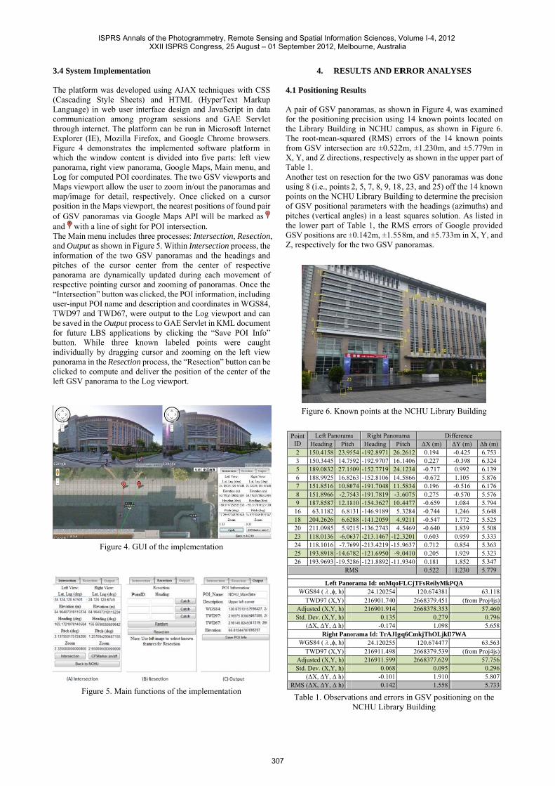
4.1 P A pafor ththe LThe fromX, YTablAnotusingpointof Gpitchthe lGSVZ, re
PoinID2356789
16182023242526
W
A St
W
A St
RM
Ta
4. RESU
Positioning Res
air of GSV panohe positioning Library Buildinroot-mean-squ
m GSV intersectY, and Z directio
e 1. ther test on reseg 8 (i.e., points ts on the NCHU
GSV positional phes (vertical anglower part of T
V positions are ±espectively for t
Figure 6. Know
nt Left PanoramaHeading Pitc150.4158 23.95150.3445 14.75189.0832 27.15188.9925 16.82151.8516 10.80151.8966 -2.75187.8587 12.1863.1182 6.81
204.2626 6.62211.0985 5.92118.0136 -6.06118.1016 -7.76193.8918 -14.67193.9693 -19.52
RM
Left PanoWGS84 (λ,ϕ, h)
TWD97 (X,Y)Adjusted (X,Y, h)td. Dev. (X,Y, h)
(ΔX, ΔY, Δ h)Right Pano
WGS84 (λ,ϕ, h)TWD97 (X,Y)
Adjusted (X,Y, h)td. Dev. (X,Y, h)
(ΔX, ΔY, Δ h)S (ΔX, ΔY, Δ h)
able 1. Observa
ULTS AND ER
sults
oramas, as showprecision using
ng in NCHU caared (RMS) ertion are ±0.522ons, respectively
ection for the tw2, 5, 7, 8, 9, 18
U Library Buildparameters withgles) in a least
Table 1, the RM±0.142m, ±1.55the two GSV pa
wn points at the
a Right Panoramh Heading Pi554 -192.8971 26.592 -192.9707 16.509 -152.7719 24.263 -152.8106 14.074 -191.7048 11.543 -191.7819 -3.810 -154.3627 10.131 -146.9189 5.288 -141.2059 4.215 -136.2743 4.637 -213.1467 -12.699 -213.4219 -15.782 -121.6950 -9.286 -121.8892 -11.MS
orama Id: onMqoF24.120254
216901.740 216901.914
0.135 -0.174
orama Id: TrAJIgq24.120255
216911.498 216911.599
0.068 -0.101 0.142
tions and errorsNCHU Library
RROR ANALY
wn in Figure 4,g 14 known poampus, as showrrors of the 142m, ±1.230m, ay as shown in th
wo GSV panor, 23, and 25) of
ding to determinh the headings squares solutio
MS errors of G58m, and ±5.733anoramas.
e NCHU Library
ama Diitch ΔX (m) .2612 0.194 .1406 0.227 .1234 -0.717 .5866 -0.672 .5834 0.196 .6075 0.275 .4477 -0.659 .3284 -0.744 .9211 -0.547 .5469 -0.640 .3201 0.603 .9637 0.712 .0410 0.205 .9340 0.181
0.522
FLCjTFsReilyMkP120.674381
2668379.451 2668378.353
0.279 1.098
q6CmkjThOLjkD120.674477
2668379.539 2668377.629
0.095 1.910 1.558
s in GSV positiy Building
YSES
, was examinedoints located onwn in Figure 6.4 known pointsand ±5.779m inhe upper part of
amas was doneff the 14 knownne the precision(azimuths) andon. As listed inoogle provided3m in X, Y, and
y Building
fference ΔY (m) Δh (m)-0.425 6.753 -0.398 6.324 0.992 6.139 1.105 5.876 -0.516 6.176 -0.570 5.576 1.084 5.794 1.246 5.648 1.772 5.525 1.839 5.508 0.959 5.333 0.854 5.363 1.929 5.323 1.852 5.347 1.230 5.779
PQA 63.118
(from Proj4js)57.460
0.7965.658
7WA 63.563
(from Proj4js)57.756
0.2965.8075.733
ioning on the
d n . s n f
e n n d n d d
ISPRS Annals of the Photogrammetry, Remote Sensing and Spatial Information Sciences, Volume I-4, 2012 XXII ISPRS Congress, 25 August – 01 September 2012, Melbourne, Australia
307

4.2 Error Sources in GSV Positioning Errors in POI’s coordinates from geometric intersection among GSV panoramas may be caused by the following sources: 1. GSV car positioning errors: According to the specification,
the worst position errors of the TOPCON IP-S2 GPS/IMU unit for 30 second outage duration (1 epoch/30s) are 0.055m and 0.030m in 2D plane and height direction, respectively and attitude errors of 0.030, 0.030, and 0.075 degrees in roll, pitch, and heading, respectively. The latitude, longitude, and elevation parameters of the GSV panorama may include systematic errors from interpolation. As shown in Table 1, the errors in Google provided GSV positional parameters dominated the errors in intersection, especially in elevation.
2. Angular resolution in panoramas: As already shown in Eq. (1), the conversion from rectangular image coordinates in level 5 zooming panorama into heading and pitch angles is about 1.63 minutes/pixel. The angular resolution will be decreased in the power of 2 when the panorama is zoomed out to lower levels, i.e., 3.25 minutes/pixel for level 4 and 6.5 minutes/pixel for level 3, etc. As a result, when the POI is not carefully located with the highest zoom level of the panorama, the heading and pitch angles of conjugate POI images from the respective panorama center may not be precise enough for deriving reliable results from intersection and resection.
3. Distortions of the panoramas: A sphere model was used for merging GSV panoramas from the planar images obtained the horizontal cameras in earlier products. On the other hand, a rectangular plane model is used in the latest Google Maps API version 3. However, the previous GSV products were not regenerated into the rectangle plane model. The panorama may include severe distortions in the upper portions (image from the 9th camera shooting the sky) and lower portions (rendered from other panoramas) as shown in Figure 7. It would be good to locate POIs on the central portions of ±30 degrees in pitch (vertical angle) according to the vertical field of view of the camera lens. The distortion of image may also happen while the GSV panorama is viewed in different web browsers as shown in Figure 8, in which Google Chrome seems well in reducing the GSV panoramic distortion.
4. Small intersection angles between the known points: The intersection angle of a POI from the two adjacent GSV panoramas may be too sharp to cause significant error in intersection (Ghilani & Wolf, 2008).
5. CONCLUSIONS This research employs Google Maps JavaScript API and Web Service, GAE for JAVA, AJAX, Proj4js, CSS and HTML in developing an internet platform for accessing the position and orientation parameters of GSV panoramas in order to determine the global positions of POI features that appear on two overlapping images by intersection, and to determine the position of the exposure center of a panorama from at least three known points by resection. Extracted 3-D positional information of the features from intersection were packed in KML format and stored in GAE Servlet for future LBS applications integrated with Google Maps and Google Earth. Experimental results from positioning known points in a pair of GSV panoramas are ±0.522m, ±1.230m, and ±5.779m for intersection and ±0.142m, ±1.558m, and ±5.381m for resection in X, Y, and Z, respectively. Potential error sources in GSV positioning were analyzed and illustrated that the errors in Google provided GSV positional parameters dominate the errors
in geometric intersection. The developed system is suitable for volumetric data collection in establishing LBS applications, in which the positional accuracy is not primarily concerned. Possible applications can be settled in finding and positioning of commercial entities, traffic signs, utility poles and manholes, landmarks, and infrastructures along the streets where GSV panoramas are available. The current state of the GSV positioning system is not complete. Future work on extending its functionalities includes adding automatic feature detection and image matching techniques for object recognition and matching among GSV panoramas. Other features in GSV auxiliary data and Google Maps can also be included to provide the user opportunities to place markers and overlay in the scene, find local business from commercial entity recognition, and lever 3D data and sequence of GSV panoramas for smart navigation.
ACKNOWLEDGEMENTS The support from the National Science Council, Taiwan, under Grant No. NSC100-2221-E005-075-MY2, was appreciated in improving the developed system in this research.
Figure 7. Distortions in the Google Street View Panorama
(A) Google Chrome
(B) Mozilla Firefox4
Figure 8. Distortion of GSV panorama in different web browsers
ISPRS Annals of the Photogrammetry, Remote Sensing and Spatial Information Sciences, Volume I-4, 2012 XXII ISPRS Congress, 25 August – 01 September 2012, Melbourne, Australia
308

REFERENCES Anguelov, D., C. Dulong, D. Filip, C. Frueh, S. Lafon, R. Lyon,
A. Ogale, L. Vincent, and J. Weave, 2010. “Google Street View: Capturing the World at Street Level,” Computer, vol. 43, no. 6, pp. 32-38.
Evenden, G. I., 2003. Cartographic Projection Procedures for the UNIX Environment—A User’s Manual, USGS Open-File Report 90-284.
Ghilani, C. D. and P. R. Wolf, 2006. Adjustment Computations: Spatial Data Analysis, 4th ed., John Wiley & Sons,
Hoboken, NJ, pp. 255-282. Ghilani, C. D. and P. R. Wolf, 2008. Elementary Surveying: An
Introduction to Geomatics, 12th ed., Pearson Education, Upper Saddle River, NJ, pp. 269-294.
OGP Geomatics, 2012. EPSG Geodetic Parameter Dataset, http://www.epsg.org/ (11 Jan. 2012).
Proj4js Track and Wiki, 2012. http://trac.osgeo.org/proj4js/ (08 Jan. 2012)
Vincent, L., 2007. “Taking online maps down to street level,” Computer, vol. 40, no. 12, pp. 118-120.
ISPRS Annals of the Photogrammetry, Remote Sensing and Spatial Information Sciences, Volume I-4, 2012 XXII ISPRS Congress, 25 August – 01 September 2012, Melbourne, Australia
309