101-17743rep14-01-27microtm rev4 hall/growth/documents/oct. 2013 - at mp... · (vdf) and free-flow...
TRANSCRIPT


Secondary Plan, Background Studies & Infrastructure Master Plans - Intensification & Annexed Lands Multi-Modal Active Transportation Master Plan - Final Technical Memorandum - Micro Model
101-17743January 27, 2014
GENIVAR
21
5.2 Road Network
The road network was verified mainly by lane configuration, lane allocations to movements and
traffic controls. The issues in network coding of the 2009 Model are summarized:
1. Inappropriate lane allocations to movements, resulting in upstream blocked turning
movements due to the back of queues downstream or the weaving issues (i.e., vehicles
making more lane changes) downstream.
2. Inappropriate length of solid lines on lanes preventing vehicles from entry.
3. Unassigned turning movements in the defined signal groups.
5.3 Truck Permissive Routes
Based on Staff Report ENG072-08, the City of Barrie employs a permissive heavy truck route
system. Appendix A – Data Collection provided a copy of the current Permissive Truck Route,
dated August 2008. The current Permissive Truck Route includes arterial roads and major
collectors. As per clarification from City staff, heavy trucks are permitted to travel on all
roadways as longs as they are taking the nearest permissive truck route to their final
destination.
However, the 2009 Model treated all the roads other than the Permissive Truck Route as
prohibited truck routes throughout the whole City. This coding resulted in the situation that the
trucks could not find a path to reach their destinations even though an OD truck demand was
taken into accounts in the 2009 Model. This coding neither complies with the City Permissive
Truck Route system nor matches truck volumes reflected in the surveyed TMCs at the City
intersections.
Therefore, the prohibited truck routes coded in the 2009 Model were removed.
5.4 Traffic Control
Besides the traffic controls (signal, stop and give-way) at an intersection, Aimsun applies a give-
way sign to define the priority rules of movements at an intersection (the permissive left-turn at
an intersection). A right-turn-on-red (RTOR) sign is also applied. The missed definitions of give-
way or RTOR signs of turnings at intersections in the 2009 Aimsun Model were corrected.
5.5 Macro Level Parameter Calibration
The parameters for the macro model mainly include the lane capacity, volume-delay functions
(VDF) and free-flow speed. These parameters were calibrated to match the calibrated Emme
macro model completed by GENIVAR. Some of the major issues were inherited from the
previous City Emme macro model, which required additional calibration.
5.5.1 Lane Capacity
The lane capacity (measured in pcu/h, that is, passenger car units per hour) was inconsistent or
incorrectly coded on sections of the same roads or classifications. The inconsistent or
incorrectly coded lane (auto) capacity was corrected.

Secondary Plan, Background Studies & Infrastructure Master Plans - Intensification & Annexed Lands Multi-Modal Active Transportation Master Plan - Final Technical Memorandum - Micro Model
101-17743January 27, 2014
GENIVAR
22
It is noteworthy that the City Aimsun Model simulates both automobiles and trucks. The micro,
meso and macro simulations share the same network and demand data. Also, the City Aimsun
Model has an input of origin-destination (OD) demand matrices from the City Emme Macro
Model. However, the City Emme Macro Model simulates auto traffic only and lane capacity is
input only for auto traffic. During the model calibration and development, a macro adjustment
scenario is necessary for OD demand matrices of automobiles and trucks. The 2009 Aimsun
Model only accounted for capacity of automobiles.
Therefore, the section capacity or lane capacity was calibrated to include capacity for
automobiles and trucks and is described in the following sections:
5.5.1.1 Lane Auto Capacity
Lane auto capacity was based on the parameter input of lane auto capacity in the Emme Macro
Model. The roads that are not under the jurisdiction of the City of Barrie, as shown in Table 5-1,
have the same parameter input of lane auto capacity as the City’s 2009 Macro Model. And the
City roads have an input of lane auto capacity that was approved by the City on March 15, 2012
for the Emme Macro Model, as shown in Table 5-2.

Secondary Plan, Background Studies & Infrastructure Master Plans - Intensification & Annexed Lands Multi-Modal Active Transportation Master Plan - Final Technical Memorandum - Micro Model
101-17743January 27, 2014
GENIVAR
23
Table 5-1 – Emme Macro Model Road Classification and Input Parameters
Type of Road Free-Flow Speed (km/h)
Lane Auto Capacity (pcu/h)
Volume Delay
Function ID
Highway 400 110 1,800 11
Other Provincial Highway 90 1,200 20
King’s Highway 60-90 700-1,000 20
Major Rural Arterial (Out of Barrie) 60-90 850 30
Minor Rural Arterial (Out of Barrie) 40-90 350-1,200 50
Highway Ramps 40-70 700-1,400 13
Table 5-2 – Emme Macro Model Road Classification and Input Parameters for Barrie Roads
Classification
Lanes (including a Centre Two-
Way Left-Turn Lane)
Free-Flow Speed (km/h)
Adjusted Lane Auto Capacitya
(pcu/h)
Volume Delay
Function ID
AR
TE
RIA
L
Major Arterial 2,4,6 45-70 750 40
Major Arterial 3,5,7 45-70 850 40
Minor Arterial 2,4,6 45-70 650 40
Minor Arterial 3,5,7 45-70 750 40
CO
LLE
CT
OR
Major Collector 2, 4 40-60 500 50
Major Collector 3, 5 40-60 550 50
Minor Collector 2 40-60 400 50
Minor Collector 3 40-60 500 50
Local 2 40 400 50
Note: “pcu/h” represents passenger car units per hour. a The adjusted lane auto capacity for arterials and collectors was approved by the City on March 15, 2012.

Secondary Plan, Background Studies & Infrastructure Master Plans - Intensification & Annexed Lands Multi-Modal Active Transportation Master Plan - Final Technical Memorandum - Micro Model
101-17743January 27, 2014
GENIVAR
24
5.5.1.2 Lane Total Capacity
Capacity is expressed in passenger car units per hour (pcu/h). The trucks are converted into
passenger car units in the calculation. However, in the macro model development, if the model
simulates auto traffic only, the lane capacity is usually reduced by a percentage from the lane
(total) capacity to account for auto traffic. Specifically, the percentage actually accounts for the
truck composition in the traffic. The City Macro Model is the case, which simulates auto traffic
only. The capacity in the City Macro Model provided in Table 5-1 and Table 5-2 is the lane auto
capacity.
Total capacity of a lane accounted for automobiles and trucks was calculated from auto capacity
based on the following:
����������� = ���������(1 − 5%) × 5% × 1.9��/���� + ���������
A typical truck percentage of five percent was applied and one truck was assumed to be
equivalent to 1.9 passenger car units.
The section capacity in the Aimsum Model was derived from lane (total) capacity and the
number of lanes accordingly.
5.5.2 Volume-Delay Functions
Volume-delay functions (VDF) were calibrated by assigned VDFs and their specifications:
1. The 2009 Model had inconsistent assigned VDFs for sections of the same road or
classification.
2. The specifications of the VDFs from the Emme Macro Model were not correctly translated in
the 2009 Aimsun Model.
5.5.3 Speed
Inconsistent speed inputs for two travel directions of the roadways were corrected throughout
the Aimsun network.
5.6 Micro Level Parameter Calibration
An Aimsun microsimulation model includes a comprehensive series of the parameters for road
sections, intersection turnings, vehicles, route choice, and simulation experiments, besides
some of the same input (speed) for the macro-simulation.
5.6.1 Section Parameters
Aimsun implements a lane-changing model to simulate the vehicle lane-changing behaviours in
three different zones. In Zone 1, the lane-changing decisions are mainly governed by the traffic
conditions of the lanes involved. In Zone 2, the intermediate zone, vehicles not driving in valid
lanes try to look for a gap and make lane-changing manoeuvres to get to a correct side of the
lane from which a turn is to be made. Lane-changing vehicles do not affect the behaviour of
vehicles in the adjacent lanes. In Zone 3, vehicles are forced to reach their valid lanes. Vehicles
may reduce speed if necessary and even come to a complete stop in order to make the change
possible. Vehicles in the adjacent lane can modify their behaviour in order to provide a gap big

Secondary Plan, Background Studies & Infrastructure Master Plans - Intensification & Annexed Lands Multi-Modal Active Transportation Master Plan - Final Technical Memorandum - Micro Model
101-17743January 27, 2014
GENIVAR
25
enough for the vehicle to succeed in changing lanes1. Two important parameters determine
these three zones, which are distances for Zone 1 and Zone 2. Distance for Zone 2 identifies
the district of Zone 3. Zone 2 is determined by distance for Zone 1 minus distance for Zone 2.
The distance for Zone 1 identifies the district of Zone 1.
Distances for Zone 1 and Zone 2 in the 2009 Aimsun Model were calibrated to improve vehicle
lane-changing behaviours.
Highway 400 On-Ramps:
For on-ramp sections, Aimsun implements a special lane-changing model, which is the on-ramp
model. It simulates the vehicles manoeuvres of merging into the main traffic stream. The
parameter of Distance On-Ramp in the 2009 Aimsun Model was also calibrated for Highway
400 On-Ramps.
5.6.2 Turning Parameters
Similar to the distances for Zone 1 and Zone 2 that control the vehicle lane-changing behaviours
on road sections, Aimsun implements the look-ahead model, which controls the lane changing
decisions according to the next turning movement in the next intersection. Two important
parameters for turnings are distances for Zone 1 and Zone 2. Different from those two
parameters, the distances for Zone 1 and Zone 2 can be propagated to the upstream road
sections. At locations where intersections are closely-spaced or where weaving sections on
highways are short, vehicles may not reach the appropriate turning lane and miss the next turn
at an intersection or junction.
Distances for Zone 1 and Zone 2 in the 2009 Model were calibrated to reduce the number of
missed turns to a minimum level.
5.6.3 Vehicle Parameters
The global vehicle parameters for cars and trucks, including maximum desired speed, maximum
acceleration and deceleration, speed acceptance, maximum give-way time, have the same
settings as the 2009 Aimsun Model shown in Figure 5-3.
1 Aimsun 7 Dynamic Simulators User’s Manual, Transportation Simulation System, November 2011.

Secondary Plan, Background Studies & Infrastructure Master Plans - Intensification & Annexed Lands Multi-Modal Active Transportation Master Plan - Final Technical Memorandum - Micro Model
101-17743January 27, 2014
GENIVAR
26
Figure 5-3 – Vehicle Parameters
5.6.4 Route Choice Parameters
When an OD demand matrix is loaded in the Aimsun model, the simulation experiment is
implemented with dynamic traffic assignment, which follows a route choice model. A C-Logit
route choice model was calibrated to simulate dynamic route choices with the following input:
1. Cycle and number of intervals: a cycle of one second and two intervals were applied.
2. Attractiveness weight: it allows to control the influence of road attractiveness has on the
cost in relation to the travel time. A weight of three was applied in the model.
3. Scale = 15, Beta =0.15 and Gamma = 1.
5.6.5 Simulation Experiment Parameters
The major parameters for the experiments are same as those in the 2009 Aimsun Model except
the number of replications and described as follows:
1. Driver reaction time: this is the time for a driver to react to speed changes in the preceding
vehicle. And the driver reaction time at stop is the time for a driver to react to a change to
the traffic light. The driver reaction time of 0.9 seconds and driver reaction time at stop of 1.1
seconds were applied. The driver reaction time should be multiple of simulation step.

Secondary Plan, Background Studies & Infrastructure Master Plans - Intensification & Annexed Lands Multi-Modal Active Transportation Master Plan - Final Technical Memorandum - Micro Model
101-17743January 27, 2014
GENIVAR
27
2. Simulation step: at each simulation step or interval, the model updates the traffic state or
traffic light, etc. The simulation step has the same time as the driver reaction time of 0.9
seconds.
3. Warm-up period: a warm up period of 15 minutes was applied to fill up the network with
traffic before the start of the simulation.
4. Vehicle arrival: vehicles were generated based on an exponential distribution.
5. Replications: In a microsimulation, each experiment replication represents a different traffic
condition generated from a random seed, as in real-world traffic conditions. It is important to
run enough experiment replications to get an average result from a microsimulation output.
The 2009 Model only had five replications (as seen from the Model file), which is not
sufficient. Different numbers of replications were tested and a total of 20 replications were
set.
Secondary Plan, Background Studies & Infrastructure Master Plans - Intensification & Annexed Lands Multi-Modal Active Transportation Master Plan - Final Technical Memorandum - Micro Model
101-17743January 27, 2014
GENIVAR
28

Secondary Plan, Background Studies & Infrastructure Master Plans - Intensification & Annexed Lands Multi-Modal Active Transportation Master Plan - Final Technical Memorandum - Micro Model
101-17743January 27, 2014
GENIVAR
29
6. Traffic Counts to Validate
The most current traffic counts provided by the City and the MTO were varied in terms of the
year, season, day of the week, and peak hours. The reliability of the traffic counts is important
for validation and has an impact on the goodness-of-fit. The following sections describe the
approaches, assumptions or methodologies that were applied.
6.1 City Roads
Most roads under the jurisdiction of Barrie had ATR counts or turning movement counts for AM
and PM peak hours on a typical mid-week day, as shown in Figure 4-1A and Figure 4-1B. The
observed section and turning data were obtained as follows:
� The observed section/link data were derived from turning movement counts or obtained
from the ATR counts. And the observed turning data were obtained from turning movement
counts.
� The observed data (section or data) were extracted for automobiles and trucks respectively.
� If the year of counts was not 2011, the traffic counts were factored up to 2011 by an annual
growth rate of one percent, which was derived from the population growth between 2011
and 2006.
6.2 Highway 400 and Ramp Terminals
Mainline Highway 400:
� Highway 400 had ATR counts observed in the spring, summer and fall. Similar to the City
Emme mid-week AM and PM peak macro models, which simulate the mid-week AM and PM
peak hour commuter trips and were calibrated and validated against the spring/fall counts
on Highway 400, the observed fall or spring traffic volumes on Highway 400 were selected
for validation of the Aimsun Micro Model.
� As the observed ATR counts had no vehicle classifications, the truck counts were derived
from the fall truck percentage observed on Highway 400 at 4th Line. Refer to Section 7.3.2 -
Commercial Vehicle Traffic for details.
� If the year of counts was not 2011, the counts were adjusted to 2011 by an annual growth of
two percent, which was derived from the annual growth of historical annual average daily
traffic (AADT) on Highway 400 from 1988 to 2008.
Highway 400 Ramp Terminals:
� Six Highway 400 ramp terminals, which are included in the Aimsun Micro Model, had traffic
counts in the fall except for two terminals at Dunlop Street. The observed section and
turning data were obtained from turning movement counts.
� The observed data (section or data) were extracted for automobiles and trucks respectively.
� The traffic counts were factored up to 2011 by an annual growth rate of 1.5 percent, which is
within the range of the City-wide growth rate and the growth rate on the mainline Highway
400.

Secondary Plan, Background Studies & Infrastructure Master Plans - Intensification & Annexed Lands Multi-Modal Active Transportation Master Plan - Final Technical Memorandum - Micro Model
101-17743January 27, 2014
GENIVAR
30

Secondary Plan, Background Studies & Infrastructure Master Plans - Intensification & Annexed Lands Multi-Modal Active Transportation Master Plan - Final Technical Memorandum - Micro Model
101-17743January 27, 2014
GENIVAR
31
7. Traffic Demand Calibration
The City Aimsun Model has a traffic demand input of origin-destination matrices obtained from
the City Emme Macro Transportation Demand Forecasting Model completed by GENIVAR.
However, it should be noticed that a macro model has a coarser level of detail such as the
network representation and traffic zoning system than what is required for a microsimulation
model given the purposes of two kinds of models. Further, the traffic demand from a macro
demand forecasting model is usually calibrated at the screenline level. Therefore, the traffic
demand from the City Emme Macro Model was calibrated and validated at the macro level for
the Aimsun model area.
7.1 Traffic Demand Spatial Disaggregation
The Aimsun Micro Model has more zones (referred to as micro zones) than the Emme Macro
Model (referred to as macro zones) for the same model area. Therefore, the traffic demand from
the Macro Model was disaggregated into the micro zones. The 2009 Aimsun Model derived
traffic demand disaggregation factors from the total population and employment for each micro
zone and applied them to the origin and destination trips. The approach is not appropriate given
the correlation between generated trips (origins or destinations) and zone density (population or
employment). GENIVAR enhanced the model with the following approach:
� The disaggregation factors were derived from the population and employment respectively
for each micro zone.
� For the AM peak model, the origin trips were disaggregated by the population
disaggregation factor and the destination trips were disaggregated by the employment
disaggregation factor, as the origin trips in the AM peak periods are more related to the
population and the destination trips are more related to the population.
� For the PM peak model, the origin trips were disaggregated by the employment
disaggregation factor and the destination trips were disaggregated by the population
disaggregation factor, as the origin trips in the PM peak periods are more related to the
employment and the destination trips are more related to the population.
The population disaggregation factors and employment disaggregation factors for the existing
2011 base year are provided in Appendix C – Model Input.
7.2 Traffic Demand Temporal Disaggregation
As in real-world traffic conditions, traffic demand varies within every hour every day. A smaller
time-sliced (e.g. 10 or 15 minutes) traffic demand can be fed into an Aimsun model for
microsimulation. Based on review of the February 2010 Final Report, existing traffic counts did
not have pronounced peaking trend within the peak hour for the 15-minute interval flow rates.
Further, the peaking trend varied at each location. A 15-minute time-sliced traffic demand was
tested for validation and was not found to improve the validation results. In fact, the exponential-
distributed traffic arrival simulates the variation of traffic within one hour. Therefore, one-hour
OD traffic demand matrices were loaded into the Aimsun Micro Model.
Secondary Plan, Background Studies & Infrastructure Master Plans - Intensification & Annexed Lands Multi-Modal Active Transportation Master Plan - Final Technical Memorandum - Micro Model
101-17743January 27, 2014
GENIVAR
32
7.3 Traffic Demand Composition
The City Emme Macro Model provides demand forecasts for auto traffic and the City Aimsun
Model simulates not only auto traffic but also commercial vehicles or trucks. The composition of
traffic demand was estimated in the following sections.
7.3.1 Auto Traffic
The initial auto traffic input for the Aimsun microsimulation was origin-destination (OD) matrices
disaggregated from the traversal OD matrices obtained from the City Emme Macro Model, as
discussed in Section 7.1 - Traffic Demand Spatial Disaggregation. The OD matrices of auto
traffic for the AM and PM peak hours were then calibrated and validated against the AM and PM
peak hour link volumes and turning movement counts for automobiles, which were adjusted to
2011 from the existing counts. Refer to the other sections for traffic counts and demand
adjustment.
7.3.2 Commercial Vehicle Traffic
The 2009 Aimsun Model applied the assumed truck demand of two percent to the calibrated
auto OD matrices and derived separate OD matrices for trucks, which were loaded into the
Aimsun network. This approach is not appropriate and accurate due to the following:
� The assumed truck percentage of two percent is too low for truck traffic on the mainline
Highway 400 and its ramp terminals based on GENIVAR’s review from the MTO observed
traffic counts on the mainline Highway 400.
� The calculated OD matrices for trucks were not calibrated and validated against the
observed traffic counts.
Table 7-1 presents the analysis results of truck percentages for the mid-week AM and PM two-
hour peak periods in the fall season on Highway 400 at 4th Line, approximately 7km or one
Highway 400 interchange away from South Barrie. The Highway 400 traffic counts were
provided by MTO for the Simcoe Transportation Study. It should be noted that the derived truck
percentages may not reflect the Highway 400 sections within the City as the count location was
located outside the city of Barrie, but indicate the high percentage of trucks on Highway 400.
The Appendix C – Model Input also provides the analysis results for the summer season. The
observed truck percentage was much higher than the two percent assumed in the 2009 Aimsun
Model.
Table 7-1 – Observed Truck Percentage on Highway 400 at 4th Line, Fall Season
AM Two-Hour Peak Period PM Two-Hour Peak Period
No. Date Day Southbound Northbound Southbound Northbound
1 10/19/2010 Tuesday 10.3% 14.2% 12.3% 6.0%
Source: Original counts were provided by MTO for the Simcoe Transportation Study.

Secondary Plan, Background Studies & Infrastructure Master Plans - Intensification & Annexed Lands Multi-Modal Active Transportation Master Plan - Final Technical Memorandum - Micro Model
101-17743January 27, 2014
GENIVAR
33
GENIVAR enhanced the model with the following approach:
� The initial OD truck demand matrices were calculated from the corresponding initial OD auto
demand matrices by applying:
o Two percent of trucks to zones with origin and destination trips within the City.
o The truck percentages shown in Table 7-1 to gate zones representing the mainline
Highway 400 for trips originated from the mainline Highway 400 or destined to the
mainline Highway 400. The observed truck percentages were assumed to be the same
for Highway 400 sections within the Aimsun model area and the same for other horizons
as well.
� The initially derived OD truck demand matrices were then calibrated and validated against
the AM and PM peak hour link volumes and turning movement counts for trucks, which were
adjusted to 2011 from the existing counts.
7.4 Demand Adjustment and Macro Level Validation
As mentioned previously, it is necessary to calibrate and validate the traffic demand from a
macro travel demand model given the level of details (e.g. network representation and zoning)
required for the Aimsun micro model and the level of calibration and validation (i.e. screenline
link level) for a macro travel demand model.
7.4.1 Demand Adjustment
The initial validation of the Aimsun Micro Model was conducted to determine if the demand
adjustment was necessary. The finding was that the initial traffic demand for both AM and PM
peak hours were not good enough. The demand adjustment was then conducted. It was based
on four real data sets (observed data): two sets of section data (including automobiles and
trucks) and two sets of turning data (including automobiles and trucks).
7.4.2 Macro Level Validation Results
Figure 7-1 and Figure 7-2 present the mid-week AM and PM peak hour macro level validation
results after demand adjustment for the existing 2011. Statistics and visual presentation of
goodness-of-fit scatterplots of the modelled link volumes to the observed link counts indicate
that the calibrated traffic demand for both automobiles and trucks was sufficiently accurate:
� The R-square values are above 98 percent, indicating that the model explains 98 percent of
the observed counts.
� The constant values are small and the slope is relatively close to 1.0, indicating a good
match of the modelled volumes and the observed counts.

Secondary Plan, Background Studies & Infrastructure Master Plans - Intensification & Annexed Lands Multi-Modal Active Transportation Master Plan - Final Technical Memorandum - Micro Model
101-17743January 27, 2014
GENIVAR
34
Figure 7-1 – Scatterplots and Goodness-of-Fit of Existing 2011 Macro Level Validation, Mid-Week AM Peak
a) Automobiles b) Trucks
Figure 7-2 – Scatterplots and Goodness-of-Fit of Existing 2011 Macro Level Validation, Mid-Week PM Peak
a) Automobiles b) Trucks
Secondary Plan, Background Studies & Infrastructure Master Plans - Intensification & Annexed Lands Multi-Modal Active Transportation Master Plan - Final Technical Memorandum - Micro Model
101-17743January 27, 2014
GENIVAR
35
8. Existing 2011 Validation
The section documents the validation results for the dynamic microsimulation of the existing
2011.
There are various statistical methods (for example, root mean square error (RMSE), chi-square
test, Theil’s U-Statistic) to measure the validation results and the goodness-of-fit. Each method
has its advantages and disadvantages. The GEH Statistic is applied in Aimsun and was used in
this study as it accounts for not only the differences of two sets of traffic data but also the order
of magnitude of the volumes. The statistic is expressed in the following:
��� = �2(! − ")#! + "
where ωandυare the simulated traffic volumes and observed traffic counts respectively.
This statistic mathematical form is similar to a chi-squared test, but it is not a true statistical test.
It is an empirical formula that has proven to be rather useful. The bounds of the GEH statistics
are defined by:
� GEH in the range from 0 to 5 means a good fit.
� GEH in the range from 5 to 10 requires further investigation.
� GEH greater than 10 is unacceptable.
In the evaluation of validation results, the study applied both the calibration targets (i.e. USDOT
and FHWA calibration targets, as shown Table 8-1) adopted in the February 2010 Final Report
and statistics and visual presentation of goodness-of-fit scatterplots.
Table 8-1 – USDOT and FHWA Calibration Targets
Criteria Target
Links with flow > 2,700 veh/h 85% cases within 400 veh/h
Links with 700 < flow < 2,700 veh/h 85% within 15% of target count
Links with flow < 700 veh/h 85% within 100 veh/h
Sum of all link flows Observed vs Simulated difference < 5%
GEH for all count locations 85% of cases < 5
GEH for Total Observed vs Simulated < 4
Source: Traffic Analysis Toolbox Volume 111: Guidelines for Applying Traffic Micro-Simulation Modeling Software, USDOT & FHWA, June 2004.
It should be noted that the targets were one sample calibration targets developed by Wisconsin
Department of Transportation (DOT) for their Milwaukee freeway system simulation model. The
targets will vary depending on the purpose of the model and the available sources.

Secondary Plan, Background Studies & Infrastructure Master Plans - Intensification & Annexed Lands Multi-Modal Active Transportation Master Plan - Final Technical Memorandum - Micro Model
101-17743January 27, 2014
GENIVAR
36
8.1 Mid-Week AM Peak Hour
FHWA Targets
Table 8-2 summarizes the mid-week AM peak hour validation results based on the Federal
Highway Administration (FHWA) calibration targets provided in Traffic Analysis Toolbox
Volumes 111: Guidelines for Traffic Micro-Simulation Modelling Software. The bounds of the link
volumes of 2,700veh/h in the first and second criterion were modified to be 2,300veh/h given the
observed volumes on Highway 400. Figure 8-1 provides GEH plots for individual locations.
Appendix D – Model provides the modelled volumes, observed traffic counts, GEH statistics
and relative difference.
Table 8-2 – Existing 2011 Micro Level Validation Summary based on FHWA Targets, Mid-Week AM Peak
Criteria Target Result
Links with flow > 2,300 veh/h (Highway 400)
85% cases within 400 veh/h 100%
Links with 700 < flow < 2,300 veh/h 85% within 15% of target count 52%
Links with flow < 700 veh/h 85% within 100 veh/h 74%
Sum of all link flows Observed vs Simulated
difference < 5% 4%
GEH for all count locations 85% of cases < 5 67%
GEH for Total Observed vs Simulated < 4 13.1
Note: 1 The 2,700 veh/h in the FHWA (Federal Highway Administration) targets were adjusted to 2,300 veh/h to include locations on
Highway 400.
Secondary Plan, Background Studies & Infrastructure Master Plans - Intensification & Annexed Lands Multi-Modal Active Transportation Master Plan - Final Technical Memorandum - Micro Model
101-17743January 27, 2014
GENIVAR
37
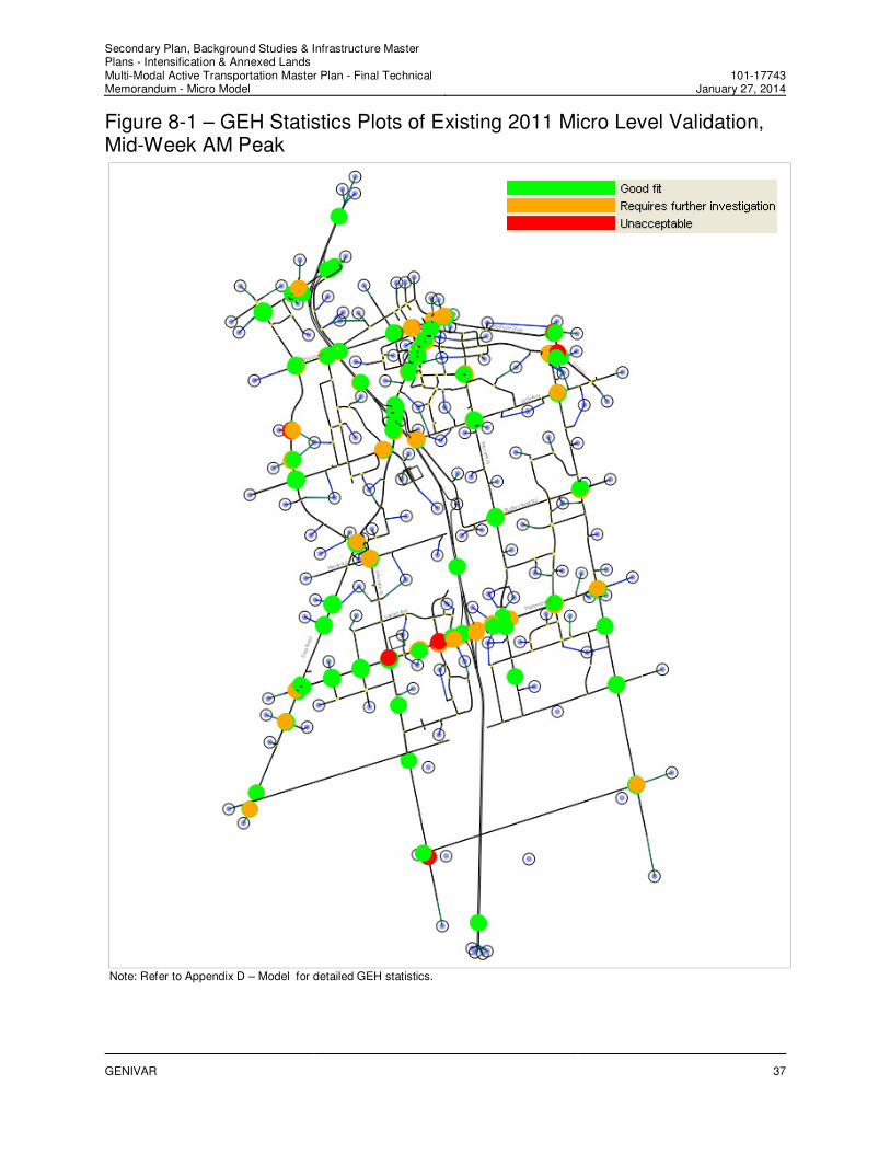
Figure 8-1 – GEH Statistics Plots of Existing 2011 Micro Level Validation, Mid-Week AM Peak
Note: Refer to Appendix D – Model for detailed GEH statistics.

Secondary Plan, Background Studies & Infrastructure Master Plans - Intensification & Annexed Lands Multi-Modal Active Transportation Master Plan - Final Technical Memorandum - Micro Model
101-17743January 27, 2014
GENIVAR
38
The findings are:
� Individual locations:
o The simulated volumes on Highway 400 have a good fit with the observed traffic counts.
Only the southbound Highway 400, west of Essa Road has a GEH statistics of 5.5,
greater than 5.0 but less than 10.0. The other count locations have a GEH statistics
below than 5.0.
o For links with counts of greater than or equal to 700veh/h and less than or equal to
2,300veh/h, 52 percent of locations have a simulated volume within 15 percent of the
observed counts.
o For links with counts of less than 700veh/h, 74 percent of locations have a simulated
volume with a difference of 100veh/h from the observed counts, which is a little bit lower
than the target of 85 percent.
� Overall:
o 67 percent of all count locations have a GEH statistics of less than or equal to 5.0, which
is less than the target of 85 percent.
o However, the sum of all link simulated volumes has a 4 percent relative difference from
all the observed counts, which meets the target.
o The GEH statistics of the total link simulated volumes versus the total link observed
counts is 13.1, higher than the target of 4.
The factors that impact on the model goodness-of-fit include:
As mentioned in Section 6, the most current traffic counts provided by the City and the MTO
were varied in terms of the year, season, day of the week, and peak hours. The observed traffic
counts were not simultaneous even though they have been adjusted to the same target year
(2011). However, the microsimulation output is simultaneous link volumes. Further, one location
usually had only one-day counts except for the ATR counts on Highway 400. Therefore, the
reliability of the traffic counts has an impact on the goodness-of-fit. As commented in the
February 2010 Final Report, the targets are usually difficult to achieve unless there is enough
reliable data.
The signal timings may not match the timings when the counts were collected. GENIVAR
assumed the timings coded in the 2009 Model except for those locations with new signal timings
provided by the City. Further, the signal progression has an impact on the volume output,
particularly at closely-spaced intersections. No offsets were input in the 2009 Model. The proper
platoon progression will reduce the delays and queues and therefore, improve the queue
discharge and the throughput.
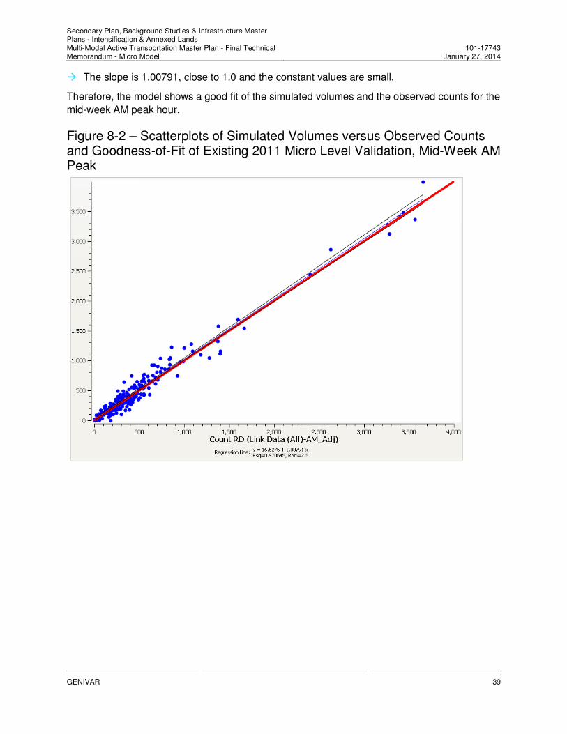
Scatterplots and Goodness-of-Fit
Figure 8-2 presents the scatterplots of the simulated volumes and the observed counts for the
mid-week AM peak hour. As shown in Figure 8-2, the model exhibits a high correlation between
the simulated volumes and the observed counts:
� The R-square value is 0.97, indicating that the model explains 97 percent of the locations.
Secondary Plan, Background Studies & Infrastructure Master Plans - Intensification & Annexed Lands Multi-Modal Active Transportation Master Plan - Final Technical Memorandum - Micro Model
101-17743January 27, 2014
GENIVAR
39
� The slope is 1.00791, close to 1.0 and the constant values are small.
Therefore, the model shows a good fit of the simulated volumes and the observed counts for the
mid-week AM peak hour.
Figure 8-2 – Scatterplots of Simulated Volumes versus Observed Counts and Goodness-of-Fit of Existing 2011 Micro Level Validation, Mid-Week AM Peak

Secondary Plan, Background Studies & Infrastructure Master Plans - Intensification & Annexed Lands Multi-Modal Active Transportation Master Plan - Final Technical Memorandum - Micro Model
101-17743January 27, 2014
GENIVAR
40
8.2 Mid-Week PM Peak Hour
FHWA Targets
Table 8-3 summarizes the mid-week PM peak hour validation results based on the FHWA
calibration targets. The bounds of the link volumes of 2,700veh/h in the first and second criterion
were modified to be 2,300veh/h given the observed volumes on Highway 400. Figure 8-3
provides GEH plots for individual locations. Appendix D – Model provides the modelled
volumes, observed traffic counts, GEH statistics and relative difference.
Table 8-3 – Existing 2011 Micro Level Validation Summary based on FHWA Targets, Mid-Week PM Peak
Criteria Target Result
Links with flow > 2,300 veh/h1 Highway
400)2
85% cases within 400 veh/h 100%
Links with 700 < flow < 2,300 veh/h1 85% within 15% of target count 49%
Links with flow < 700 veh/h 85% within 100 veh/h 65%
Sum of all link flows Observed vs Simulated
difference < 5% 0.3%
GEH for all count locations 85% of cases < 5 63%
GEH for Total Observed vs Simulated < 4 1.1
Notes: 1 The 2,700 veh/h in the FHWA (Federal Highway Administration) targets were adjusted to 2,300 veh/h to include locations
on Highway 400. 2 The links include the eastbound Mapleview Drive at Highway 400 Northbound Off-Ramp Terminal.

Secondary Plan, Background Studies & Infrastructure Master Plans - Intensification & Annexed Lands Multi-Modal Active Transportation Master Plan - Final Technical Memorandum - Micro Model
101-17743January 27, 2014
GENIVAR
41
Figure 8-3 – GEH Statistics Plots of Existing 2011 Micro Level Validation, Mid-Week PM Peak
Note: Refer to Appendix D – Model for detailed GEH statistics.

Secondary Plan, Background Studies & Infrastructure Master Plans - Intensification & Annexed Lands Multi-Modal Active Transportation Master Plan - Final Technical Memorandum - Micro Model
101-17743January 27, 2014
GENIVAR
42
The findings are:
� Individual locations:
o The simulated volumes on Highway 400 have a good fit with the observed traffic counts.
Only the southbound Highway 400, north of Mapleview Drive has a GEH statistics of 6.4,
greater than 5.0 but less than 10.0. The other count locations have a GEH statistics
below than 5.0.
o For links with counts of greater than or equal to 700veh/h and less than or equal to
2,300veh/h, 49 percent of locations have a simulated volume within 15 percent of the
observed counts.
o For links with counts of less than 700veh/h, 65 percent of locations have a simulated
volume with a difference of 100veh/h from the observed counts, which is lower than the
target of 85 percent.
� Overall:
o 65 percent of all count locations have a GEH statistics of less than or equal to 5.0, which
is a little less than the target of 85 percent.
o However, the sum of all link simulated volumes has a 0.3 percent relative difference from
all the observed counts, which meets the target of 5 percent.
o The GEH statistics of the total link simulated volumes versus the total link observed
counts is 1.1, which meets the target of 4.
As mentioned previously, the reliability of the traffic counts and signal timings may impact on the
model goodness-of-fit. The signal progression has an impact on the volume output, particularly
at closely-spaced intersections.
For example, three intersections at Essa Road (Highway 400 Southbound Ramp Terminal,
Highway 400 Northbound Ramp Terminal and Fairview Road) do not show a good match for the
eastbound simulated volumes. These three locations are closely located with a high weaving on
the eastbound traffic between the Highway 400 Southbound Ramp Terminal and Fairview Road
due to the high eastbound right-turning volumes at Fairview Road. The traffic counts were
obtained in the fall of 2010 and the signal timings were for the spring of 2011 (based on the
timing sheets). Green times were adjusted for the eastbound phase at the Highway 400
Northbound Ramp Terminal to improve the results on the eastbound given the simulated
northbound volumes higher than the observed counts.
The reliability of the traffic counts may impact the validation results. Observed counts on a link
did not balance due to different survey day, season and year. Insufficient loading points of
demand for a traffic zone may reduce the traffic concentration that causes congestion, which
has been sufficiently calibrated.
Scatterplots and Goodness-of-Fit
Figure 8-4 presents the scatterplots of the simulated volumes and the observed counts for the
mid-week PM peak hour. As shown in Figure 8-4, the model exhibits a high correlation between
the simulated volumes and the observed counts:

Secondary Plan, Background Studies & Infrastructure Master Plans - Intensification & Annexed Lands Multi-Modal Active Transportation Master Plan - Final Technical Memorandum - Micro Model
101-17743January 27, 2014
GENIVAR
43
� The R-square value is about 0.958, indicating that the model explains 95.8 percent of the
locations.
� The slope is 0.95555, close to 1.0 and the constant values are small.
Therefore, the model shows a good fit of the simulated volumes and the observed counts for the
mid-week PM peak hour.
Figure 8-4 – Scatterplots of Simulated Volumes versus Observed Counts and Goodness-of-Fit of Existing 2011 Micro Level Validation, Mid-Week PM Peak

Secondary Plan, Background Studies & Infrastructure Master Plans - Intensification & Annexed Lands Multi-Modal Active Transportation Master Plan - Final Technical Memorandum - Micro Model
101-17743January 27, 2014
GENIVAR
44
8.3 Summary of Base Model Validation
� The prior City 2009 Aimsun Model simulated the mid-week AM and PM peak hour traffic
conditions for the south section of the city of Barrie, bounded by Lockhart Road in the south,
Tiffin Street in the north, Huronia Road / Lakeshore Boulevard in the east, and Ferndale
Drive / Essa Road in the west.
� The expanded Aimsun Model covers the area from the south limits of the City in the south,
Tiffin Street and Dunlop Street in the north, Huronia Road / 10 Sideroad in the east and
Veterans Drive / 5 Sideroad in the west. The area covers part of the western section of the
annexed area and the potential Highway 400 Interchange at McKay Road.
� The most current data and information were collected for the model development and
calibration, including:
o existing TMC and ATR traffic counts
o updated signal timings
o existing traffic classification data on the mainline Highway 400
o City Permissive Truck Route System
o the model input from the newly calibrated Emme Macro Model
� This report documents the comprehensive process of correction, verification, calibration,
enhancement and expansion completed by GENIVAR for the prior 2009 Aimsun Model. The
major calibration includes:
o network topography, lane allocations for turning movements, signal groups, traffic control
and signal timings
o lane restrictions on trucks
o macro level parameters: lane or section capacity, volume-delay functions (VDFs) and
free-flow speed
o micro level parameters: sections, turnings, route choice and simulation experiment
The findings of the base model validation are summarized as follows:
� The traffic demand input of origin-destination matrices for the City Aimsun Micro Model was
first calibrated and validated at the macro level for the Aimsun model area. The demand
calibration includes spatial disaggregation, temporal disaggregation, demand composition
(automobiles and trucks).
� The initial micro level validation results indicate that the initial traffic demand for both AM
and PM peak hours were not good enough. The demand adjustment was then conducted
based on four real data sets (observed data): two sets of section data (including
automobiles and trucks) and two sets of turning data (including automobiles and trucks).
� Statistics and visual presentation of goodness-of-fit for the macro level validation of the AM
and PM peak hour traffic demand input indicate that the modelled link volumes have a good
match of the observed link counts for both automobiles and trucks. Therefore, the calibrated

Secondary Plan, Background Studies & Infrastructure Master Plans - Intensification & Annexed Lands Multi-Modal Active Transportation Master Plan - Final Technical Memorandum - Micro Model
101-17743January 27, 2014
GENIVAR
45
AM and PM peak hour traffic demand for both automobiles and trucks was sufficiently
accurate for the input of the microsimulation of traffic conditions for the base year 2011.
� The micro level validation results of the simulated volumes and the observed counts for the
AM and PM peak hours of the base year 2011 have the following findings:
o Overall, the model has a good fit between the simulated volumes and the observed
counts from their scatterplots although the results at individual locations do not meet the
FHWA calibration targets well.
o It is noteworthy that the FHWA calibration targets are one sample calibration targets
developed by Wisconsin Department of Transportation (DOT) for their Milwaukee
freeway system simulation model. The targets will vary depending on the purpose of the
model and the available sources.
o The simulated volumes on Highway 400 have a good fit with the observed traffic counts
in both directions at four locations (i.e. north of Dunlop Street, west of Essa Road, north
of Mapleview Drive and north of Innisfil Beach Road). All locations have a GEH statistics
below than 5.0 except for one location in the AM and PM peak hours respectively, which
is greater than 5.0 but less than 10.0.
o The reliability of the traffic counts and signal timings matching the counts have an impact
on the model goodness-of-fit. The unreliable counts (i.e., counts obtained from different
survey days, seasons and years), traffic variations, inaccurate signal timings and
improper signal progression would affect the validation results.
To conclude, the newly-calibrated Aimsun Micro Model has a good fit between the simulated
volumes and the observed counts for the base year 2011 and can be applied to assess the
impact of future land use developments and evaluate various solution alternatives to future
traffic operations.

Secondary Plan, Background Studies & Infrastructure Master Plans - Intensification & Annexed Lands Multi-Modal Active Transportation Master Plan - Final Technical Memorandum - Micro Model
101-17743January 27, 2014
GENIVAR
46

Secondary Plan, Background Studies & Infrastructure Master Plans - Intensification & Annexed Lands Multi-Modal Active Transportation Master Plan - Final Technical Memorandum - Micro Model
101-17743January 27, 2014
GENIVAR
47
9. Future Year Network Scenarios
The future preferred road networks recommended in the City’s Multimodal Active Transportation
Master Plan (TMP) were fine-tuned and analyzed with the Aimsun microsimulation software for
the south section of the City of Barrie, including the annexed area, to identify the potential
operational deficiencies on the future networks. The Aimsun microsimulation models were
developed from the calibrated and validated base year model.
9.1 Travel Demand Forecasts and Adjustment
The future total travel demand for Aimsun microsimulation models includes auto traffic and
commercial vehicle traffic. The auto traffic forecasts for horizon years were obtained from the
subarea traversal OD trip matrices of the City’s travel demand forecasting Emme model, which
was developed based on the population and employment forecasts for the City and the Region.
The subarea traversal OD trip matrices for horizon years were adjusted by the difference of the
base year travel demand between the demand forecasting Emme model and the calibrated
Aimsun model. The commercial vehicle traffic was estimated by applying the calibrated truck
percentage to the future auto traffic.
Table 9-1 – Total Travel Demand Forecasts, Aimsun Subarea
Horizon Year AM Peak Hour PM Peak Hour
Total Total
2011 21,218 28,991
2031 33,743 45,318
9.2 Road Network Improvements
Future improvements to the existing road network include planned improvements by the City
and the MTO, and those recommended from the Emme macro level analyses and the
development of the TMP.
9.2.1 City Road Improvements
Major roadway projects in the preferred road network for the City roads include:
� Dunlop Street widening to:
o five lanes from Tiffin Street to Ferndale Drive
o seven lanes across Highway 400
o seven lanes from Cedar Pointe Drive to Anne Street
� Ferndale Drive widening to five lanes from Dunlop Street to Tiffin Street
� Essa Road widening to:
o five lanes from Ferndale Drive to Mapleton Avenue

Secondary Plan, Background Studies & Infrastructure Master Plans - Intensification & Annexed Lands Multi-Modal Active Transportation Master Plan - Final Technical Memorandum - Micro Model
101-17743January 27, 2014
GENIVAR
48
o three lanes from Mapleton Avenue to past Salem Road
o seven lanes from Fairview Road to Ardagh Road
� Bryne Drive extension having five lanes from 680m south of Essa Road to 530m north of
Caplan Drive
� Harvie Road / Big Bay Point Road widening to:
o three lanes from Essa Road to Veterans Drive
o five lanes from Veterans Drive to Bryne Drive
o seven lanes across Highway 400
o seven lanes from Bryne Drive to Huronia Road
� Huronia Road widening to:
o three lanes from Big Bay Point Road to City’s south limit
o five lanes from Herrell Avenue to Big Bay Point Road
� Hurst Drive widening to five lanes from Minets Point Road to Bay Lane
� Lakeshore Drive widening to four lanes with turning lanes from Tiffin Street to Minets Point
Road
� Tiffin Street widening to:
o five lanes at the Highway 400 underpass
o five lanes from Ferndale Drive to Lakeshore Drive
o three lanes from Dunlop Street to Ferndale Drive
� Little Avenue widening to three lanes from Fairview Road to Hurst Drive
� Lockhart Road / Salem Road widening to:
o three lanes from Essa Road to Veterans Drive
o five lanes across Highway 400 (four-lane structure)
o five lanes from Veterans Drive to Prince William Way
� Mapleview Drive widening to seven lanes from Huronia Road to the west side of GO Train
railway line, transitioning to five lanes before the railway crossing
� McKay Road widening to:
o five lanes across Highway 400
o five lanes from the Reid Drive extension to Huronia Road
� Veterans Drive widening to:
o three lanes from McKay Road to the City’s south limit
o five lanes from Salem Road to McKay Road

Secondary Plan, Background Studies & Infrastructure Master Plans - Intensification & Annexed Lands Multi-Modal Active Transportation Master Plan - Final Technical Memorandum - Micro Model
101-17743January 27, 2014
GENIVAR
49
9.2.2 Highway 400 Mainline and Interchanges
Planned improvements/expansions on Highway 400 were identified in the Preliminary Design
Report (PDR) of the Highway 400 Planning and Preliminary Design Study. The timing for
Highway 400 widening is uncertain and is not identified in the PDR. It is assumed that the
Highway 400 widening and interchange improvements will be implemented by horizon 2031.
Planned Improvements
The planned improvements include:
� The mainline Highway 400 will be widened from the current six lanes to 10 lanes from the
Bayfield Interchange to the Essa Interchange and eight lanes elsewhere.
� The Dunlop Street Interchange geometric configurations include:
o realigned E/W-N on-ramp with Hart Drive
o realigned S-W off-ramp loop
o widened N-E/W off-ramp (three lanes for the N-W off-ramp)
� The Essa Road Interchange geometric configurations include:
o additional lane on the N-E/W off-ramp
o realigned E-S on-ramp loop
o realigned W-N on-ramp loop
o a new W-S on-ramp in the southwest quadrant
o additional lane on the S-E/W off-ramp
TMP Recommended Improvements
Two new Highway 400 interchanges at Big Bay Point Road and McKay Road were
recommended in the City TMP:
� a partial four-ramp parclo A4 interchange without the northbound on-ramps at Big Bay Point
Road and an additional lane on the E-N on-ramp at the Essa Road Interchange
� a full six-ramp parclo A4 interchange at McKay Road

Secondary Plan, Background Studies & Infrastructure Master Plans - Intensification & Annexed Lands Multi-Modal Active Transportation Master Plan - Final Technical Memorandum - Micro Model
101-17743January 27, 2014
GENIVAR
50
Secondary Plan, Background Studies & Infrastructure Master Plans - Intensification & Annexed Lands Multi-Modal Active Transportation Master Plan - Final Technical Memorandum - Micro Model
101-17743January 27, 2014
GENIVAR
51
10. Future Year Traffic Conditions
The following sections document the forecasted future traffic conditions for the ultimate network
and traffic demand of the TMP. It should be noted that:
� This exercise of the Aimsun microsimulation is not intended as an intersection capacity
analysis, but to fine-tune the recommendations for the strategic long-term planning.
� The future signal timings and phasing plans were not optimized for all signalized
intersections. Instead, they were adjusted to address operational issues (long queues, long
delay, forecasted volumes, etc.) observed in the model runs. The traffic operations may be
improved with better signal timings, phasing and coordination. However, these refinements
will be done as part of preliminary and detailed design studies.
� The intersection levels of service (LOS) or delays from the Aimsun microsimulation indicate
future traffic congestion; however, they do not comply with Highway Capacity Manual 2010
(HCM 2010) performance measures. HCM evaluates LOS by the control delay while the
Aimsun delay output includes the total delay, which is the difference between the time each
vehicle would take driving at its desired speed and the experienced travel time. In addition,
the intersection delay in HCM accounts for the whole approach, while the intersection delay
from Aimsun considers only the incoming sections (if an approach is coded as multiple
connected sections, the current Aimsun 7.0 does not consider the whole approach).
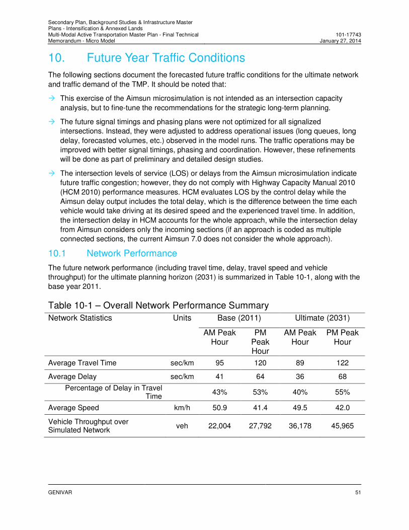
10.1 Network Performance
The future network performance (including travel time, delay, travel speed and vehicle
throughput) for the ultimate planning horizon (2031) is summarized in Table 10-1, along with the
base year 2011.
Table 10-1 – Overall Network Performance Summary
Network Statistics Units Base (2011) Ultimate (2031)
AM Peak Hour
PM Peak Hour
AM Peak Hour
PM Peak Hour
Average Travel Time sec/km 95 120 89 122
Average Delay sec/km 41 64 36 68
Percentage of Delay in Travel Time
43% 53% 40% 55%
Average Speed km/h 50.9 41.4 49.5 42.0
Vehicle Throughput over Simulated Network
veh 22,004 27,792 36,178 45,965

Secondary Plan, Background Studies & Infrastructure Master Plans - Intensification & Annexed Lands Multi-Modal Active Transportation Master Plan - Final Technical Memorandum - Micro Model
101-17743January 27, 2014
GENIVAR
52
The future ultimate network has the following findings:
� In the AM peak hour, the average delay experienced by drivers would be reduced from
41seconds per kilometre in the base year to 36 seconds per kilometre in the future. Drivers
would experience 40 percent of delay in the travel time, compared to the 43 percent in the
base year 2011.
� In the PM peak hour, the average delay experienced by drivers would be increased from 64
seconds per kilometre in the base year to 68 seconds per kilometre in the future. Drivers
would experience two percent more delay in the travel time, increasing from 53 percent of
delay in the travel time to 55 percent.
� The serviced demand would see an approximately 66 percent increase in both the AM and
PM peak hours. The vehicle throughput would increase from 22, 004 vehicles to 36,178
vehicles in the AM peak hour and the vehicle throughput would increase from 27, 792
vehicles to 45,965 vehicles in the PM peak hour.
In summary, in spite of the planned growth, the future network in Southern Barrie would perform
in a similar manner to the base year with the recommended improvements in place. The future
network would have slight improvements in the future AM peak hour and have some increased
congestion in the future PM peak hour compared to the base year.
10.2 City Arterial Roads
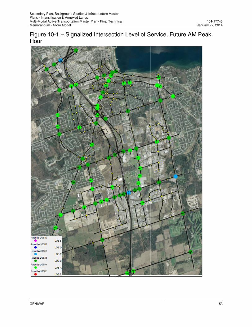
Intersection Level of Service / Delay
The estimated intersection levels of service at all signalized intersections from the Aimsun
microsimulation are shown in Figure 10-1 and Figure 10-2 respectively for the AM and PM peak
hours. The results have the following findings:
� The future network would experience more congestion with 21 signalized intersections
operating at LOS C or worse in the PM peak hour, compared to three intersections in the
AM peak hour.
� The intersections on Tiffin Street from Anne Street to Lakeshore Drive, and Essa Road from
Gowan Street to Tiffin Street would experience longer delays in the PM peak hour given the
close spacing of these intersections.
� Five signalized intersections on Mapleview Drive from Bryne Drive to Bayview Drive would
experience longer delays and have LOS C or worse in the PM peak hour.
� Of the 74 signalized intersections, two intersections (Tiffin Street at Anne Street and
Mapleview Drive at Barrieview Drive) would operate at LOS E in the PM peak hour, thereby
approaching capacity, as shown in Figure 10-2. Southbound through and left-turning
movements are critical at the intersection of Tiffin Street and Anne Street. The critical
movements at the intersection of Mapleview Drive and Barrieview Drive are eastbound
through movements and northbound right-turning movements.
As mentioned previously, the Aimsun microsimulation is to validate the recommendations for roadways at a strategic long-term planning level for the City’s TMP. As such individual intersection operations were only optimised at a high level. Further refinement of these intersection operations can be improved during the preliminary and detailed design studies.
Secondary Plan, Background Studies & Infrastructure Master Plans - Intensification & Annexed Lands Multi-Modal Active Transportation Master Plan - Final Technical Memorandum - Micro Model
101-17743January 27, 2014
GENIVAR
53
Figure 10-1 – Signalized Intersection Level of Service, Future AM Peak Hour

Secondary Plan, Background Studies & Infrastructure Master Plans - Intensification & Annexed Lands Multi-Modal Active Transportation Master Plan - Final Technical Memorandum - Micro Model
101-17743January 27, 2014
GENIVAR
54
Figure 10-2 – Signalized Intersection Level of Service, Future PM Peak Hour

Secondary Plan, Background Studies & Infrastructure Master Plans - Intensification & Annexed Lands Multi-Modal Active Transportation Master Plan - Final Technical Memorandum - Micro Model
101-17743January 27, 2014
GENIVAR
55
Figure 10-3 – Simulated Travel Speed, Future PM Peak Hour
A) Snapshot 1
B) Snapshot 2

Secondary Plan, Background Studies & Infrastructure Master Plans - Intensification & Annexed Lands Multi-Modal Active Transportation Master Plan - Final Technical Memorandum - Micro Model
101-17743January 27, 2014
GENIVAR
56
C) Snapshot 3
Simulated Travel Speed
As the worst-case traffic conditions, Figure 10-3 presents the simulated travel speeds in the PM
peak hour. The yellow-coded link indicates that the average travel speed is in the range of
30km/h to 48km/h, corresponding to 50 to 80 percent of the typical posted speed of 60km/h for
an arterial road. The red-coded link has an average travel speed below 30km/h. The thickness
of the color-coded link indicates the degree of the travel speed reduction from the posted speed.
The thicker the link is, the more the travel speed reduction would be. The simulated travel
speeds indicate that the following sections/roads would experience more congestion, compared
to other sections and roads:
� Dunlop Street from Ferndale Drive to Anne Street, particularly in the westbound direction
� Tiffin Street from Ferndale Drive to Lakeshore
� Essa Road from Ardagh Road / Bryne Drive to Tiffin Street
� the intersecting locations of Tiffin Street, Essa, Bradford Street and Lakeshore Drive
� Harvie Road and Big Bay Point Road from Essa Road to Welham Road
� Mapleview Drive from Essa Road to Bayview Drive
� Salem Road at Essa Road
� Huronia Road from Lockhart Road to McKay Road

Secondary Plan, Background Studies & Infrastructure Master Plans - Intensification & Annexed Lands Multi-Modal Active Transportation Master Plan - Final Technical Memorandum - Micro Model
101-17743January 27, 2014
GENIVAR
57
10.3 Highway 400 Performance
10.3.1 Highway 400 Mainline
Five Highway 400 interchanges (Dunlop Street, Essa Road, Big Bay Point Road, Mapleview
Drive and McKay Road) are within the Aimsun model area. The overall mainline performance
was assessed for six highway sections.
It should be noted that the density is the average density within a section and the LOS was
evaluated based on the LOS criteria for basic freeway segments (Exhibit 11-5 of HCM 2010), as
shown in Table 10-2. Even if the analyzed section may include a basic freeway segment, a
weaving segment, a freeway merge segment (an on-ramp) and a freeway diverge segment (an
off-ramp), the LOS criteria (density) for other segments than basic segments are either lower
than or similar to the basic freeway segment. For planning purposes, the LOS criteria for basic
freeway segments were applied.
Table 10-2 – LOS Criteria for Basic Freeway Segments
Source: Highway Capacity Manual 2010.
Table 10-3 and Table 10-4 summarize the Highway 400 mainline performance for the ultimate
horizon year AM and PM peak hours respectively. The performance measures include traffic
flow in vehicles per hour (veh/h), average travel speed in kilometres per hour (km/h), density in
passenger cars per mile per lane (pc/mil/ln) and related to LOS. The two tables also provide the
Highway 400 mainline performance for the base year 2011.
As shown in Table 10-3 and Table 10-4, currently the sections between Dunlop Street and Essa
are operating over capacity in both the southbound and northbound directions in the PM peak
hour. Except for the southbound direction south of Maplevie Drive, other sections on Highway
400 mainline are operating a level of service C or worse. With the improvements in place, the
Highway 400 mainline would operate a satisfactory level of service C or better on the six
analyzed sections by 2031.

Ta
ble
10
-3 –
Hig
hw
ay 4
00
Ma
inli
ne
Pe
rfo
rma
nc
e (
20
31
vs
. 2
01
1),
Fu
ture
AM
Pe
ak
Ho
ur
Lan
eF
low
Avera
ge
Tra
vel S
peed
Den
sit
yL
OS
Lan
eF
low
Avera
ge
Tra
vel S
peed
Den
sit
yL
OS
veh/h
km
/hpc/m
il/ln
veh/h
km
/hpc/m
il/ln
1H
WY
400 S
B N
ort
h o
f D
unlo
p3
3453
94.4
21.1
C5
4710
102.4
12.7
B
2H
WY
400 S
B D
unlo
p t
o E
ssa
33995
92.0
19.8
C5
5216
98.9
13.6
B
3H
WY
400 S
B E
ssa t
o B
ig B
ay P
oin
t3
3421
98.8
16.3
B5
5358
91.4
17.9
B
4H
WY
400 S
B B
ig B
ay P
oin
t to
Maple
vie
w3
3421
98.8
16.3
B5
5239
87.8
19.8
C
5H
WY
400 S
B M
aple
vie
w t
o M
cK
ay
33123
100.8
15.4
B4
4089
100.2
15.0
B
6H
WY
400 S
B S
outh
of
McK
ay
33123
100.8
15.4
B4
4235
100.7
15.8
B
1H
WY
400 N
B N
ort
h o
f D
unlo
p3
3276
97.3
15.9
B5
5798
93.8
18.9
C
2H
WY
400 N
B E
ssa t
o D
unlo
p3
3366
98.8
16.5
B5
5568
99.4
16.0
B
3H
WY
400 N
B B
ig B
ay P
oin
t to
Essa
32776
101.2
11.5
B5
4412
101.4
14.1
B
4H
WY
400 N
B M
aple
vie
w t
o B
ig B
ay P
oin
t3
2776
101.2
11.5
B6
5105
95.2
13.0
B
5H
WY
400 N
B M
cK
ay t
o M
aple
vie
w3
2436
101.6
11.8
B4
4454
93.9
16.6
B
6H
WY
400 N
B S
outh
of
McK
ay
32436
101.6
11.8
B4
3258
103.5
11.1
B
Note
: 1.
HW
Y –
Hig
hw
ay,
NB
– n
ort
hbound a
nd S
B –
south
bound.
2.
The f
ollo
win
g p
ara
mete
rs a
re d
efined a
s:
1).
flo
w -
flo
w o
utp
ut
from
Aim
sun,
avera
ged b
y s
ections a
nd m
easure
d in v
ehic
les (
veh/h
)
2).
den
sit
y -
the d
ensity m
easure
d in p
assenger
cars
per
mile
per
lane (
pc/m
il/ln
)
3).
LO
S -
level of
serv
ice,
cate
gorize
d b
ased o
n E
xhib
it 1
1-5
of
2010 H
CM
Base Y
ear
2011
Ho
rizo
n 2
031
Hig
hw
ay 4
00 S
ou
thb
ou
nd
Hig
hw
ay 4
00 N
ort
hb
ou
nd
No
.L
ocati
on
10
1-1
77
43
tab
20
13
-09
-19
Hw
y4
00
Pe
rfo
rma
nce
_2
01
1-2
03
1-H
WY
40
0_
20
31
vs2
01
1A
M_
Rp
t

Tab
le 1
0-4
– H
igh
way 4
00 M
ain
lin
e P
erf
orm
an
ce (
2031 v
s.
2011),
Fu
ture
PM
Peak H
ou
r
Lan
eF
low
Avera
ge
Tra
vel
Sp
eed
Den
sit
yL
OS
Lan
eF
low
Avera
ge
Tra
vel
Sp
eed
Den
sit
yL
OS
ve
h/h
km
/hp
c/m
il/ln
ve
h/h
km
/hp
c/m
il/ln
1H
WY
40
0 S
B N
ort
h o
f D
un
lop
33
67
98
7.9
34
.10
D5
59
38
10
0.0
16
.0B
2H
WY
40
0 S
B D
un
lop
to
Essa
33
94
26
8.7
60
.42
F5
67
58
88
.92
0.5
C
3H
WY
40
0 S
B E
ssa
to
Big
Ba
y P
oin
t3
29
59
88
.32
7.0
8D
55
55
99
0.5
18
.4C
4H
WY
40
0 S
B B
ig B
ay P
oin
t to
Ma
ple
vie
w3
29
59
88
.32
7.0
8D
55
38
28
6.8
20
.5C
5H
WY
40
0 S
B M
ap
levie
w t
o M
cK
ay
32
26
21
02
.51
0.7
6A
44
23
79
7.9
15
.7B
6H
WY
40
0 S
B S
ou
th o
f M
cK
ay
32
26
21
02
.51
0.7
6A
43
44
11
01
.81
2.4
B
1H
WY
40
0 N
B N
ort
h o
f D
un
lop
34
07
59
3.7
22
.54
C5
55
57
95
.61
8.4
C
2H
WY
40
0 N
B E
ssa
to
Du
nlo
p3
42
10
76
.05
4.5
3F
56
07
69
7.0
19
.6C
3H
WY
40
0 N
B B
ig B
ay P
oin
t to
Essa
34
24
49
2.1
25
.12
C5
51
92
10
0.4
18
.4C
4H
WY
40
0 N
B M
ap
levie
w t
o B
ig B
ay P
oin
t3
42
44
92
.12
5.1
2C
66
05
19
1.0
17
.6B
5H
WY
40
0 N
B M
cK
ay t
o M
ap
levie
w3
38
06
99
.21
9.4
6C
45
42
29
1.9
21
.4C
6H
WY
40
0 N
B S
ou
th o
f M
cK
ay
33
80
69
9.2
19
.46
C4
50
09
98
.71
8.9
C
Note
: 1. H
WY
– H
ighw
ay,
NB
– n
ort
hbound a
nd S
B –
south
bound.
2.
Th
e f
ollo
win
g p
ara
me
ters
are
de
fin
ed
as:
1).
flo
w -
flo
w o
utp
ut
fro
m A
imsu
n,
ave
rag
ed
by s
ectio
ns a
nd
me
asu
red
in
ve
hic
les (
ve
h/h
)
2).
de
ns
ity -
th
e d
en
sity m
ea
su
red
in
pa
sse
ng
er
ca
rs p
er
mile
pe
r la
ne
(p
c/m
il/ln
)
3).
LO
S -
le
ve
l o
f se
rvic
e,
ca
teg
orize
d b
ase
d o
n E
xh
ibit 1
1-5
of
20
10
HC
M
No
.L
ocati
on
Base Y
ear
2011
Ho
rizo
n 2
031
Hig
hw
ay
40
0 S
ou
thb
ou
nd
Hig
hw
ay
40
0 N
ort
hb
ou
nd
10
1-1
77
43
tab
20
13
-09
-19
Hw
y4
00
Pe
rfo
rma
nce
_2
01
1-2
03
1-H
WY
40
0_
20
31
vs2
01
1P
M_
Rp
t
Secondary Plan, Background Studies & Infrastructure Master Plans - Intensification & Annexed Lands Multi-Modal Active Transportation Master Plan - Final Technical Memorandum - Micro Model
101-17743January 27, 2014
GENIVAR
60
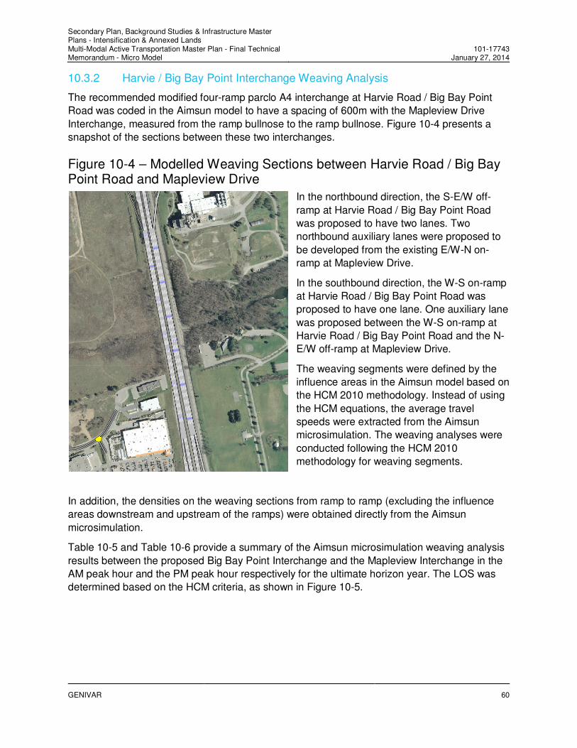
10.3.2 Harvie / Big Bay Point Interchange Weaving Analysis
The recommended modified four-ramp parclo A4 interchange at Harvie Road / Big Bay Point
Road was coded in the Aimsun model to have a spacing of 600m with the Mapleview Drive
Interchange, measured from the ramp bullnose to the ramp bullnose. Figure 10-4 presents a
snapshot of the sections between these two interchanges.
Figure 10-4 – Modelled Weaving Sections between Harvie Road / Big Bay Point Road and Mapleview Drive
In the northbound direction, the S-E/W off-
ramp at Harvie Road / Big Bay Point Road
was proposed to have two lanes. Two
northbound auxiliary lanes were proposed to
be developed from the existing E/W-N on-
ramp at Mapleview Drive.
In the southbound direction, the W-S on-ramp
at Harvie Road / Big Bay Point Road was
proposed to have one lane. One auxiliary lane
was proposed between the W-S on-ramp at
Harvie Road / Big Bay Point Road and the N-
E/W off-ramp at Mapleview Drive.
The weaving segments were defined by the
influence areas in the Aimsun model based on
the HCM 2010 methodology. Instead of using
the HCM equations, the average travel
speeds were extracted from the Aimsun
microsimulation. The weaving analyses were
conducted following the HCM 2010
methodology for weaving segments.
In addition, the densities on the weaving sections from ramp to ramp (excluding the influence
areas downstream and upstream of the ramps) were obtained directly from the Aimsun
microsimulation.
Table 10-5 and Table 10-6 provide a summary of the Aimsun microsimulation weaving analysis
results between the proposed Big Bay Point Interchange and the Mapleview Interchange in the
AM peak hour and the PM peak hour respectively for the ultimate horizon year. The LOS was
determined based on the HCM criteria, as shown in Figure 10-5.

Secondary Plan, Background Studies & Infrastructure Master Plans - Intensification & Annexed Lands Multi-Modal Active Transportation Master Plan - Final Technical Memorandum - Micro Model
101-17743January 27, 2014
GENIVAR
61
Figure 10-5 – LOS Criteria for Weaving Segments
Source: Exhibit 12-10 of Highway Capacity Manual 2010.
The results have the following findings:
� The weaving volume ratios on the northbound weaving segment were 0.38 in both the AM
and PM peak hours. The weaving volume ratios on the southbound weaving segment were
0.37 and 0.34 in the AM and PM peak hours respectively.
� The average speeds of the weaving vehicles on the northbound and southbound weaving
segments were in the range of 75km/h to 85km/h in the AM and PM peak hours.
� The northbound weaving segment would operate at LOS B in both the AM and PM peak
hours. In the PM peak hour, the density of 20.0pc/mil/ln was on the boundary of LOS B and
LOS C.
� The southbound weaving segment would operate at LOS C in both the AM and PM peak
hours.
� The average densities (pc/mil/ln) from the Aimsun microsimulation output and the HCM
estimated densities (pc/mil/ln) combined with the measured travel speeds from the Aimsun
microsimulation was close.
To conclude, the level of service in the weaving segment between the recommended
interchange at Harvie Road / Big Bay Point Road and the existing interchange at Mapleview
Drive would be better than or equal to LOS C, which is satisfactory. There would be no weaving
issues based on the recommended configurations and geometry and the forecast weaving
volumes. It is worth investigation as part of Phase 3 and Phase 4 of the EA Study for the
recommended interchange at Harvie Road / Big Bay Point Road. Once preliminary and detailed
designs for the proposed interchange are developed it is important to reanalyse the operations
of the interchange and weaving characteristics with adjacent interchanges in more detail. The
preliminary and detailed designs allow for the exact weaving distances and interchange
geometrics to be taken into account and will permit more precise analyses to be undertaken,
10.3.3 Ramp Terminals
Table 10-7 shows the overall intersection levels of service at the ramp terminals of the five interchanges in Southern Barrie. The west terminal at the Dunlop Street Interchange and the two terminals at the Mapleview Street Interchange would operate at LOS C for the ultimate horizon year. The other terminals would operate at a LOS of B or better.

Secondary Plan, Background Studies & Infrastructure Master Plans - Intensification & Annexed Lands Multi-Modal Active Transportation Master Plan - Final Technical Memorandum - Micro Model
101-17743January 27, 2014
GENIVAR
62
10.4 Additional Preliminary Improvements
The Aimsun microsimulation identified operational deficiencies on the ultimate future networks,
such as left- and right-turn lanes due to high turning volumes, queuing backup at the closely-
spaced intersections, excessive delays, etc. Additional improvements, as summarized in Table
10-8, are recommended to ensure that the overall future road network operates optimally.
These improvements include adding dual left-turn lanes, channelized right-turn lanes and new
signals.
The option of roundabouts should be explored at some intersection locations during the
preliminary and detailed design phases to improve intersection operations. The benefit of
adding roundabouts as opposed to signalised intersections is that a roundabout often reduces
the number of approach lanes required, can improve safety and offers better off-peak traffic
operations with fewer stops for vehicles.
It should be noted that the list of new signalized intersections identified in Table 10-8 only reflects the Aimsun modelled area from the simulation and does not represent all new city-wide signalized intersections.
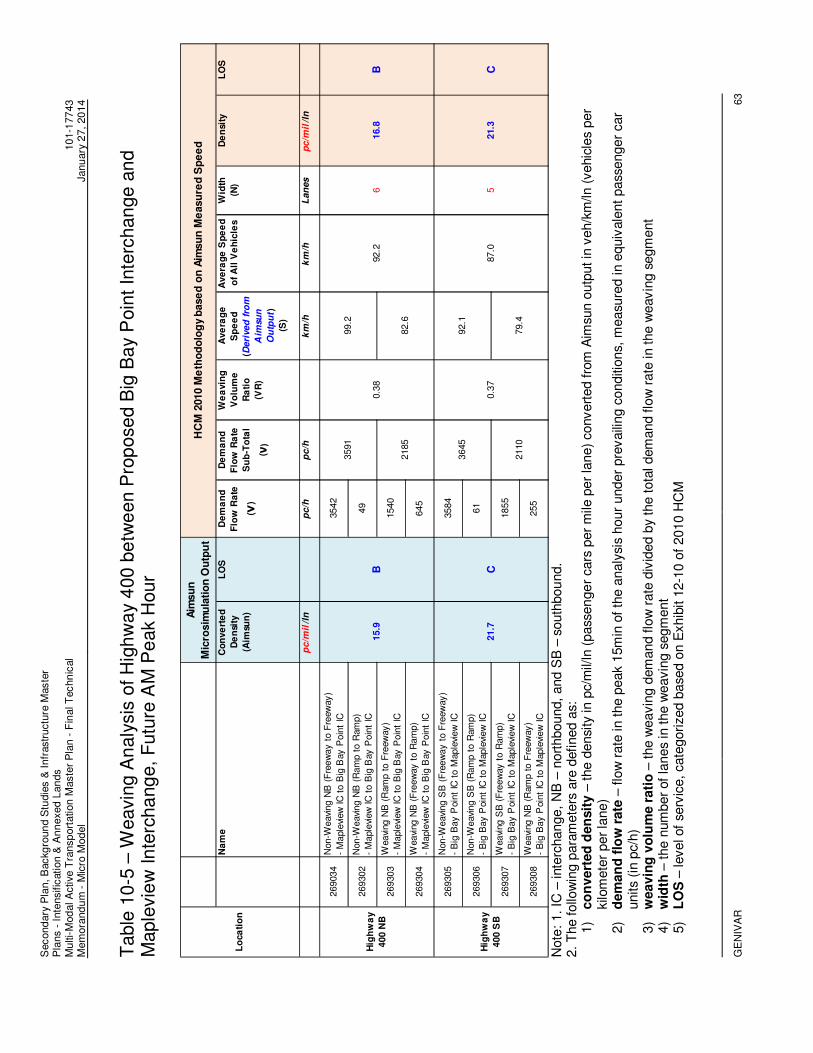
Second
ary
Pla
n, B
ackg
roun
d S
tudie
s &
Infr
astr
uctu
re M
aste
r P
lans -
Inte
nsific
ation &
An
nexed L
an
ds
Mu
lti-
Mod
al A
ctive T
ransp
ort
ation
Maste
r P
lan
- F
inal T
echn
ical
Mem
ora
nd
um
- M
icro
Mod
el
10
1-1
77
43
Janu
ary
27,
20
14
GE
NIV
AR
63
Table
10-5
– W
eavin
g A
naly
sis
of H
igh
wa
y 4
00 b
etw
een P
rop
ose
d B
ig B
ay P
oin
t In
terc
han
ge a
nd
Maple
vie
w In
terc
ha
ng
e,
Futu
re A
M P
eak H
our
N
ote
: 1. IC
– inte
rchange,
NB
– n
ort
hbound,
and S
B –
south
bou
nd.
2.
The follo
win
g p
ara
mete
rs a
re d
efined a
s:
1)
co
nvert
ed
den
sit
y –
the d
ensi
ty in p
c/m
il/ln
(pass
en
ge
r cars
per
mile
per
lane)
convert
ed fro
m A
imsu
n o
utp
ut in
veh/k
m/ln (
vehic
les
per
kilo
mete
r per
lane)
2)
dem
an
d f
low
rate
– flo
w r
ate
in t
he p
eak 1
5m
in o
f th
e a
naly
sis
hour
under
pre
vaili
ng c
onditi
ons,
measu
red in e
quiv
ale
nt
pass
enger
car
units
(in p
c/h
) 3)
weavin
g v
olu
me r
ati
o –
the w
eavin
g d
em
and flo
w r
ate
div
ided b
y the t
ota
l dem
and flo
w r
ate
in the w
eavin
g s
egm
ent
4)
wid
th –
the n
um
ber
of
lanes
in the w
eavin
g s
egm
ent
5)
LO
S –
level of
serv
ice, cate
gori
zed b
ase
d o
n E
xhib
it 1
2-1
0 o
f 2010 H
CM
Na
me
Co
nve
rte
d
De
nsi
ty
(Aim
sun
)
LO
SD
em
an
d
Flo
w R
ate
( ν)
De
ma
nd
Flo
w R
ate
Su
b-T
ota
l
( ν)
We
avin
g
Vo
lum
e
Ra
tio
(VR
)
Ave
rag
e
Sp
ee
d
( Deri
ved
fro
m
Aim
su
n
Ou
tpu
t )
(S)
Ave
rag
e S
pe
ed
of
All
Ve
hic
les
Wid
th
(N)
De
nsit
yL
OS
pc/m
il/l
np
c/h
pc/h
km
/hk
m/h
Lan
es
pc/m
il/l
n
269034
Non-W
eavi
ng N
B (
Fre
ew
ay t
o F
reew
ay)
- M
aple
view
IC
to B
ig B
ay P
oin
t IC
3542
269302
Non-W
eavi
ng N
B (
Ram
p t
o R
am
p)
- M
aple
view
IC
to B
ig B
ay P
oin
t IC
49
269303
Weavi
ng N
B (
Ram
p t
o F
reew
ay)
- M
aple
view
IC
to B
ig B
ay P
oin
t IC
1540
269304
Weavi
ng N
B (
Fre
ew
ay t
o R
am
p)
- M
aple
view
IC
to B
ig B
ay P
oin
t IC
645
269305
Non-W
eavi
ng S
B (
Fre
ew
ay t
o F
reew
ay)
- B
ig B
ay P
oin
t IC
to M
aple
view
IC
3584
269306
Non-W
eavi
ng S
B (
Ram
p t
o R
am
p)
- B
ig B
ay P
oin
t IC
to M
aple
view
IC
61
269307
Weavi
ng S
B (
Fre
ew
ay t
o R
am
p)
- B
ig B
ay P
oin
t IC
to M
aple
view
IC
1855
269308
Weavi
ng N
B (
Ram
p t
o F
reew
ay)
- B
ig B
ay P
oin
t IC
to M
aple
view
IC
255
C
2110
79.4
0.3
7
92.1
87.0
521.3
B
2185
82.6
Hig
hw
ay
400 S
B21.7
C
3645
0.3
8
99.2
92.2
616.8
Lo
ca
tio
n
Aim
su
n
Mic
rosim
ula
tio
n O
utp
ut
HC
M 2
010 M
eth
od
olo
gy
base
d o
n A
imsu
n M
easu
red
Sp
ee
d
Hig
hw
ay
400 N
B15.9
B
3591
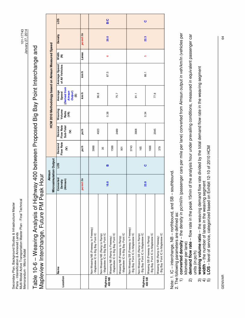
Second
ary
Pla
n, B
ackg
roun
d S
tudie
s &
Infr
astr
uctu
re M
aste
r P
lans -
Inte
nsific
ation &
An
nexed L
an
ds
Mu
lti-
Mod
al A
ctive T
ransp
ort
ation
Maste
r P
lan
- F
inal T
echn
ical
Mem
ora
nd
um
- M
icro
Mod
el
10
1-1
77
43
Janu
ary
27,
20
14
GE
NIV
AR
64
Table
10-6
– W
eavin
g A
naly
sis
of H
igh
wa
y 4
00 b
etw
een P
rop
ose
d B
ig B
ay P
oin
t In
terc
han
ge a
nd
Maple
vie
w In
terc
ha
ng
e,
Futu
re P
M P
eak H
our
Note
: 1. IC
– inte
rchange,
NB
– n
ort
hbound,
and S
B –
south
bou
nd.
2.
The follo
win
g p
ara
mete
rs a
re d
efined a
s:
1)
co
nvert
ed
den
sit
y –
the d
ensi
ty in p
c/m
il/ln
(pass
en
ge
r cars
per
mile
per
lane)
convert
ed fro
m A
imsu
n o
utp
ut in
veh/k
m/ln (
vehic
les
per
kilo
mete
r per
lane)
2)
dem
an
d f
low
rate
– flo
w r
ate
in t
he p
eak 1
5m
in o
f th
e a
naly
sis
hour
under
pre
vaili
ng c
onditi
ons,
measu
red in e
quiv
ale
nt
pass
enger
car
units
(in p
c/h
) 3)
weavin
g v
olu
me r
ati
o –
the w
eavin
g d
em
and flo
w r
ate
div
ided b
y the t
ota
l dem
and flo
w r
ate
in the w
eavin
g s
egm
ent
4)
wid
th –
the n
um
ber
of
lanes
in the w
eavin
g s
egm
ent
5)
LO
S –
level of
serv
ice, cate
gori
zed b
ase
d o
n E
xhib
it 1
2-1
0 o
f 2010 H
CM
Na
me
Co
nve
rte
d
De
nsi
ty
(Aim
sun
)
LO
SD
em
an
d
Flo
w R
ate
( ν)
De
ma
nd
Flo
w R
ate
Su
b-T
ota
l
( ν)
We
avin
g
Vo
lum
e
Ra
tio
(VR
)
Ave
rag
e
Sp
ee
d
(Deri
ved
fro
m
Aim
sun
Ou
tpu
t)
(S)
Ave
rag
e S
pe
ed
of
All
Ve
hic
les
Wid
th
(N)
De
nsi
tyL
OS
pc/m
il/l
np
c/h
pc/h
km
/hk
m/h
Lan
es
pc/m
il/l
n
Non-W
eavi
ng N
B (
Fre
ew
ay t
o F
reew
ay)
- M
aple
view
IC
to B
ig B
ay P
oin
t IC
3988
Non-W
eavi
ng N
B (
Ram
p t
o R
am
p)
- M
aple
view
IC
to B
ig B
ay P
oin
t IC
35
Weavi
ng N
B (
Ram
p t
o F
reew
ay)
- M
aple
view
IC
to B
ig B
ay P
oin
t IC
1588
Weavi
ng N
B (
Fre
ew
ay t
o R
am
p)
- M
aple
view
IC
to B
ig B
ay P
oin
t IC
901
Non-W
eavi
ng S
B (
Fre
ew
ay t
o F
reew
ay)
- B
ig B
ay P
oin
t IC
to M
aple
view
IC
3743
Non-W
eavi
ng S
B (
Ram
p t
o R
am
p)
- B
ig B
ay P
oin
t IC
to M
aple
view
IC
165
Weavi
ng S
B (
Fre
ew
ay t
o R
am
p)
- B
ig B
ay P
oin
t IC
to M
aple
view
IC
1666
Weavi
ng N
B (
Ram
p t
o F
reew
ay)
- B
ig B
ay P
oin
t IC
to M
aple
view
IC
379
C
2045
77.8
0.3
4
91.1
86.1
522.3
B/C
2489
75.7
Hig
hw
ay
400 S
B22.8
C
3908
0.3
8
96.8
87.5
620.0
Lo
ca
tio
n
Aim
su
n
Mic
rosim
ula
tio
n O
utp
ut
HC
M 2
010
Me
tho
do
log
y b
ase
d o
n A
imsu
n M
easu
red
Sp
ee
d
Hig
hw
ay
400 N
B18.8
B
4023

Second
ary
Pla
n, B
ackg
roun
d S
tudie
s &
Infr
astr
uctu
re M
aste
r P
lans -
Inte
nsific
ation &
An
nexed L
an
ds
Mu
lti-
Mod
al A
ctive T
ransp
ort
ation
Maste
r P
lan
- F
inal T
echn
ical
Mem
ora
nd
um
- M
icro
Mod
el
10
1-1
77
43
Janu
ary
27,
20
14
GE
NIV
AR
65
Table
10-7
– L
evels
of S
erv
ice a
t In
terc
han
ge R
am
p T
erm
inals
, H
ori
zo
n Y
ear
203
1
D
un
lop
Str
ee
t IC
E
ssa
Ro
ad
IC
B
ig B
ay P
oin
t IC
M
ap
levie
w D
rive
IC
M
cK
ay R
oad
IC
L
eg
en
d
2031 AM Peak Hour
2031 PM Peak Hour
Note
: IC
– inte
rchange a
nd L
OS
– level of
serv
ice.

Table 10-8 - Additional Roadway Improvements Derived from the Aimsun Microsimulation
No. Locations Suggested Improvements / Configurations Right-Of-Way Implication
1Dunlop St. at E/W-N On-Ramp /
Hart Dr.
- Dual EB left-turn lanes due to high forecast EB left-turning volumes onto
the Highway 400 NB On-Ramp in the PM peak.
- Two WB through lanes.
Seven lanes are OK.
2 Dunlop St. at S-W Off-Ramp
- Remove the Yield traffic control for the S-W Off-Ramp
- The third WB through lane (auxiliary lane) starting at the S-W Off-Ramp to
improve the discharge rate of traffic from the S-W Off-Ramp.
Seven lanes are OK.
3 Dunlop Highway 400 Interchange
- E/W-S On-Ramp - Two-lane SB On-Ramp.
Additional lane on the E/W-S On-Ramp;
Two auxiliary lanes tapering down to one
auxiliary lane at the entrance to Highway
400.
4Dunlop St. / E/W-S On-Ramp /
Cedar Pointe Dr.
- Dual WB left-turn lanes on Dunlop St. due to high forecast WB left-turning
volumes onto the Highway 400 SB On-Ramp in the PM peak.
- One SB through lane and one SB shared-through lane on Cedar Pointe Dr.
Additional lane on Dunlop St. at the
intersection; Additional lane on Cedar
Pointe Dr. at the intersection.
5Essa Rd. from Gowan St. to Tiffin
St. / Bradford St.
- An exclusive left-turn lane to accommodate the left-turning traffic at two
closely-spaced signalized intersections at Gowan St. (adjacent to GO
Station) and Tiffin St.
Five lanes on Essa Rd. from Gowan St. to
Tiffin St. / Bradford St.
6Tiffin St. from Essa Rd. / Bradford
St. to Lakeshore Dr.
- Dual EB left-turn lanes to accommodate high forecast EB left-turning traffic
at two closely-spaced signalized intersections at Essa Rd. / Bradford St. and
Lakeshore Dr. This location will be the critical bottleneck location for the
Tiffin-Lakeshore Corridor. The turning traffic from Essa Rd., Bradford St. as
well as Tiffin St. would create queue backup and weaving issues.
- Signal progression at two intersections.
Six to seven lanes on Tiffin St. from Essa
Rd. / Bradford St. to Lakeshore Dr.
7 Lakeshore Dr. at Tiffin St. - Two receiving lanes On Lakeshore Dr. due to dual EB left-turn lanes.Four lanes on Lakeshore Dr. at Tiffin St. to
two lanes.
8 Anne St. at Essa Rd. - An exclusive SB left-turn lane on Anne St.Four lanes on Anne St. from Campbell
Ave. / Centre St. to Essa Rd.
9 Essa Rd. at Fairview Rd.- Channelized EB right-turn due to high forecast right-turning volumes onto
Fairview Rd. in the PM peak.
Protect right-of-way at the southwest
quadrant.
10 Fairview Rd. at Essa Rd.
- Convert the existing exclusive NB right-turn lane to provide two NB through
lanes on Fairview Rd. connecting with the two-lane E/W-N on-ramp, due to
the NB through volumes (close to 1000 vehicles) at the signalized
intersection.
Five lanes recommended in the TMP are
OK.
11 Fairview Rd. at Little Ave.
- Dual SB left-turn lanes due to high forecast SB left-turning volumes onto
Little Ave. in the PM peak.
- Two received lanes on Little Ave.
Four lanes on Little Ave. from Fairview Rd.
to Marshall St.
12 Fairview Rd. at Big Bay Point Rd.- Channelized WB right-turn due to high forecast right-turning volumes onto
Fairview Rd. in the PM peak.
Protect right-of-way at the northeast
quadrant.
13 Minets Point Rd. at Lakeshore Dr.- Dual NB left-turn lanes due to high forecast NB left-turning volumes onto
Lakeshore Dr. in the PM peak.
Five lanes on Minets Point Rd. from
Lakeshore Dr. to Yonge St.
14 Ardagh Rd. at Essa- Dual SB left-turn lanes due to high forecast SB left-turning volumes onto
Essa Rd. in the AM peak.
Six lanes on Ardagh Rd. from Morrow Rd.
to Essa Rd.
15Big Bay Point Rd. between Hwy 400
S-E/W Off-Ramp and Bayview Dr.
- Add a new signalized intersection on Big Bay Point Rd. due to growth on
the southwest quadrant of Big Bay Point Rd. and Bayview Dr.
16Bayview Dr. between Big Bay Point
Rd. and Churchill Dr.
- Add a new signalized intersection on Bayview Dr. due to growth on the
southwest quadrant of Big Bay Point Rd. and Bayview Dr.
17 Veterans Dr. at Salem Rd. - New signalized intersection.
18 Veterans Dr. at McKay Rd. - New signalized intersection.
19 Tiffin St. at Dyment Rd. - New signalized intersection.
20 Essa Rd. at Harvie Rd. - New signalized intersection.
21 Essa Rd. at Salem Rd. - New signalized intersection to reduce delays on Salem Rd.
22 Ardagh Rd. at Morrow Rd.
- Consider dual SB left-turn lanes on Ardagh Rd. at Essa Rd. or a new signal
on Ardagh Rd. at Morrow Rd., which will be coordinated with the adjacent
existing signal at Essa Rd., to improve the turning movements at Morrow
Rd. onto/from Ardagh Rd. The turning movements at Morrow Rd. will be
impacted by the high SB left-turning volumes on Ardagh Rd. at Essa Rd.
Also, an existing parking lot is located across the street of Morrow Rd.
New or Upgrade Intersections
101-17743tab13-10-15AimsunRecommendations_Rev1-Recommendations

Secondary Plan, Background Studies & Infrastructure Master Plans - Intensification & Annexed Lands Multi-Modal Active Transportation Master Plan - Final Technical Memorandum - Micro Model
101-17743January 27, 2014
GENIVAR
67
11. Conclusions
The following conclusions can be made:
� The base year Aimsun model has been sufficiently re-calibrated. The validation results
indicate that the base year model has a good fit between the simulated volumes and the
observed counts for the base year, and can be applied to assess the impact of future land
use developments and evaluate various solution alternatives to future traffic operations.
� The future preferred road networks recommended in the City’s Transportation Master Plan
(TMP) were fine-tuned and analyzed with the Aimsun microsimulation analyses for the south
section of the City of Barrie to identify the potential operational deficiencies on the future
networks.
� Additional preliminary improvements were recommended based on the identified operational
deficiencies in the Aimsun microsimulation.
� Based on the future traffic operations analyses, the future network in Southern Barrie would
be functional with the implementation of the TMP recommended improvements and the
additional improvements that have been identified.


Appendices
A. Data Collection
B. Corrections and Calibrations of the 2009 Aimsun Model
C. Model Input
D. Model Validation Results


Appendix A
Data Collection


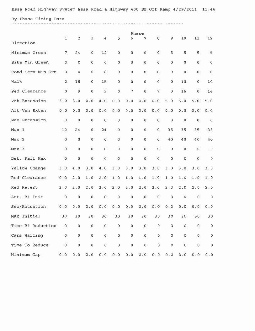


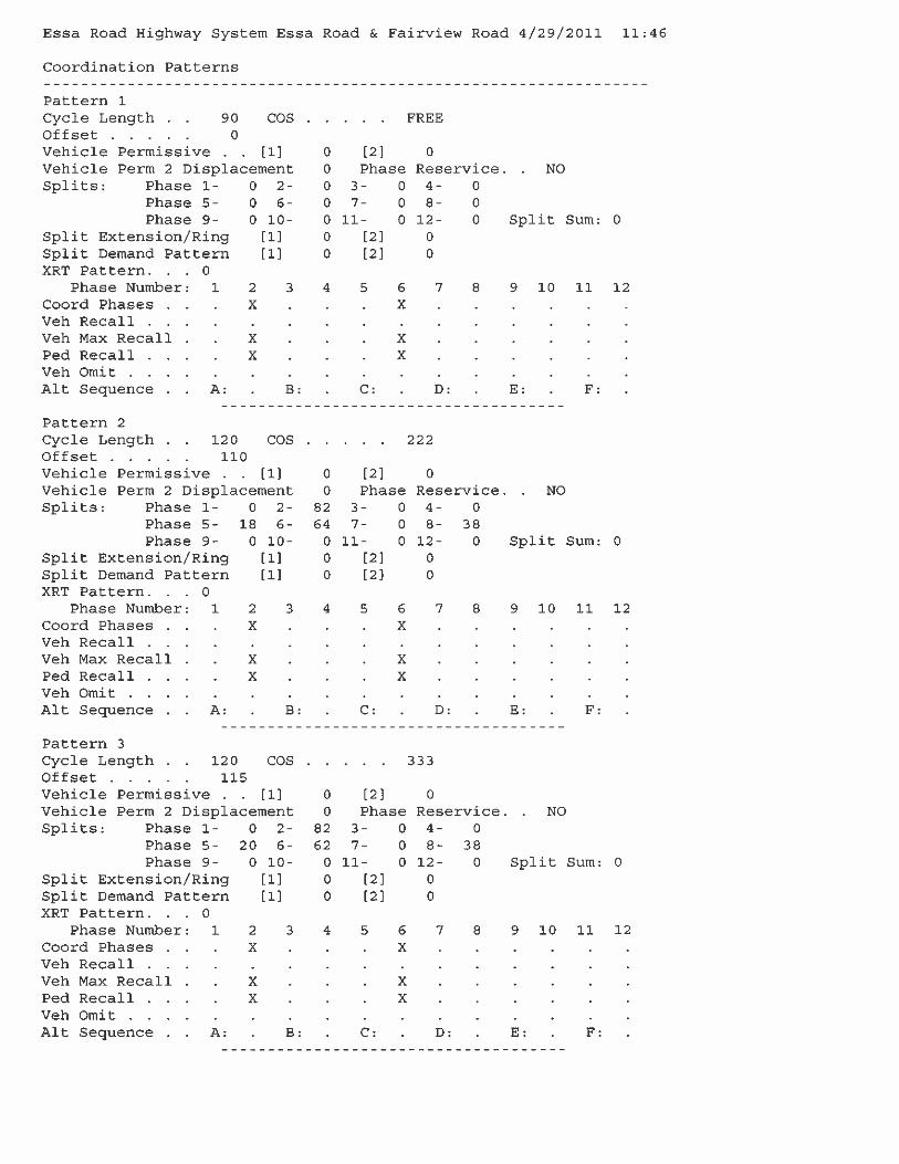


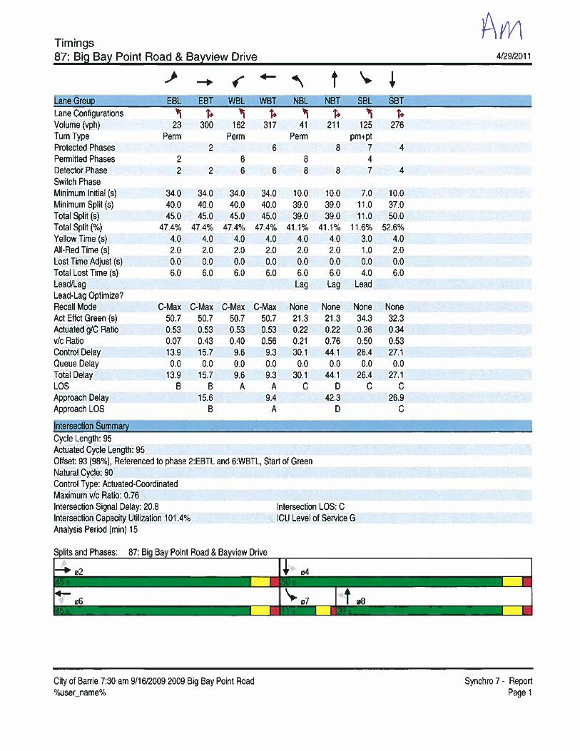
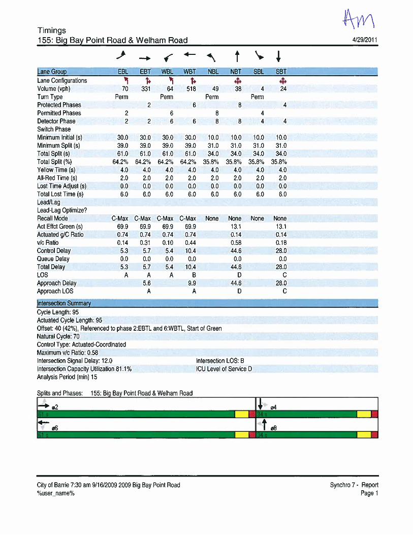

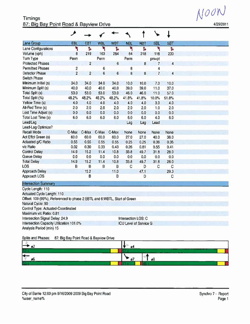
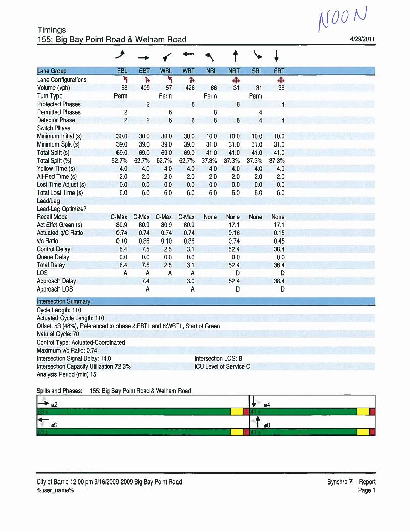


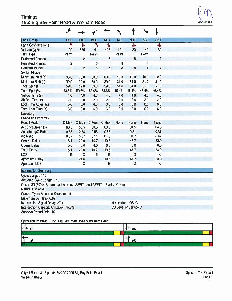


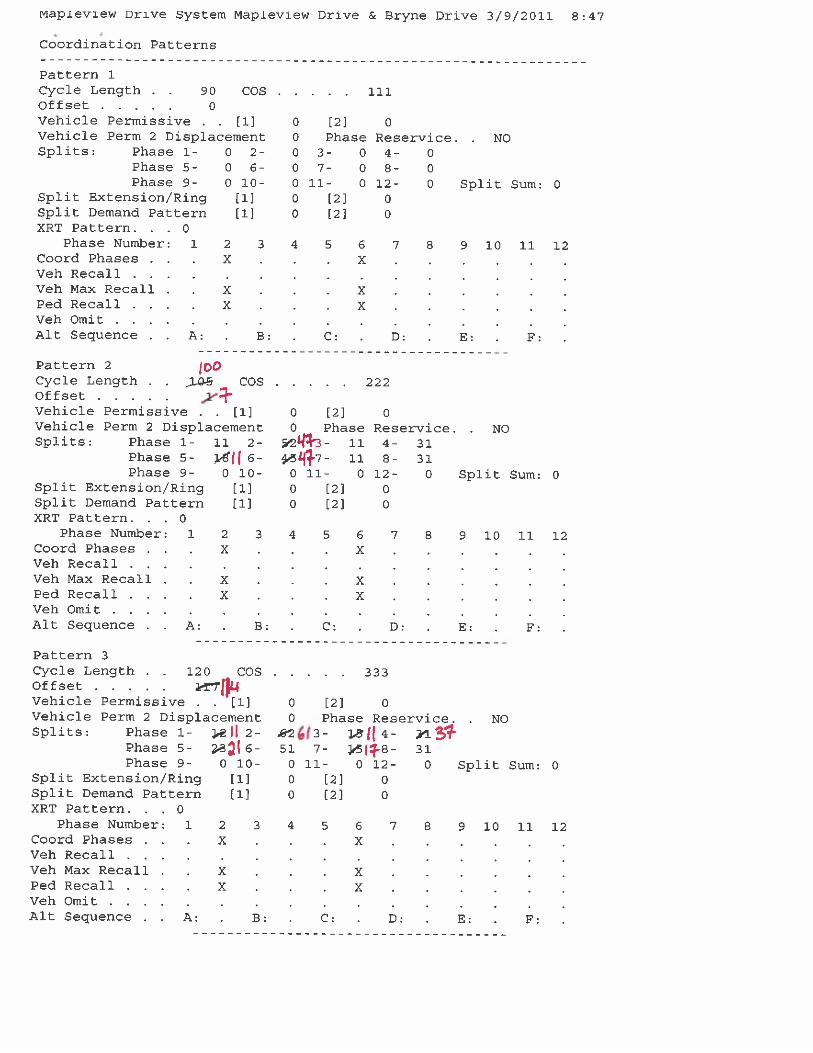


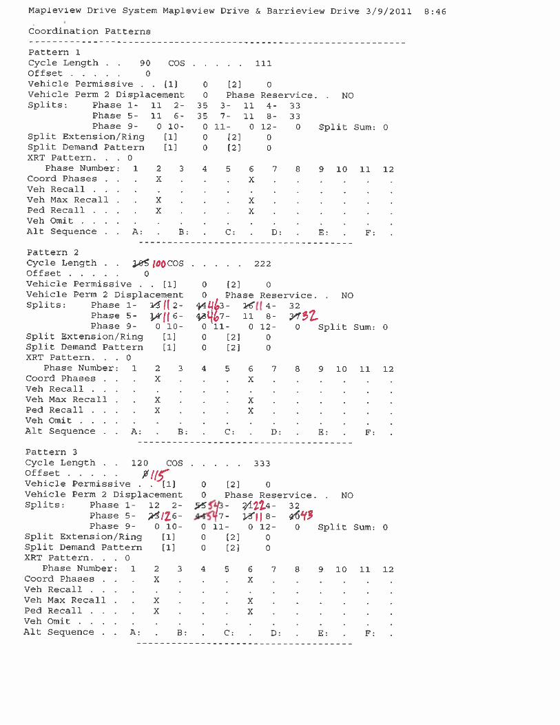


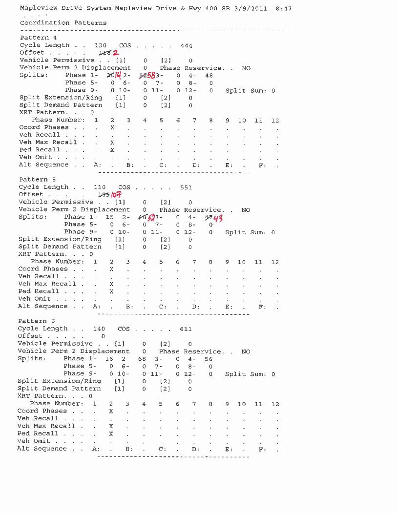

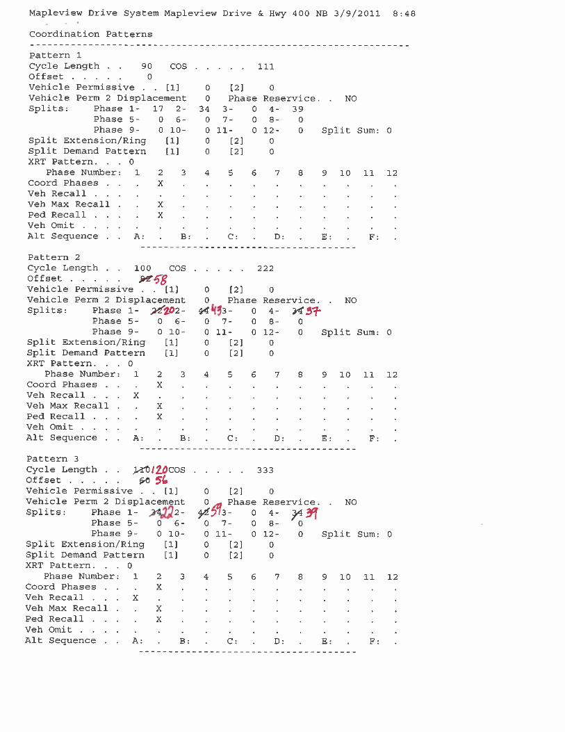


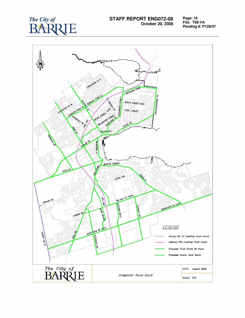
STAFF REPORT ENG072-08 October 20, 2008
Page: 16 File: T08-VA Pending #: P129/07

Appendix B
Corrections and Calibrations of the 2009 Aimsun Model


TECHNICAL MEMORANDUM
MARKHAM 600 Cochrane Drive, Floor 5, Markham, Ontario L3R 5K3 Tel.: 905.475.7270 Fax: 905.475.5994
101-17743mem13-10-16MicroCalibration_Rev.docx
Date: October16, 2013
To: Mr. W. Bando, P.Eng., City of Barrie
Copies: Eric Peissel, Mehemed Delibasic
From: Thomas You
Project No.: 101-17743
Subject: Corrections and Calibrations of the 2009 Aimsun Model
This Technical Memorandum is intended to document the issues of the 2009 Aimsun Model and model corrections, calibrations, enhancement and expansion completed by GENIVAR. The issues are demonstrated with some snapshots for the Model.
1. Zone Centroids and Connections
As the model area is expanded to include the part of the Annexation Area, five zone centroids (208, 209, 210, 211 and 212) have been added to the model to be consistent with the zoning system in the macro adjustment / assignment scenarios for the future horizons.
Zone centroid connections were reviewed and adjusted to reflect the actual traffic loading points for each zone. For example, zone centroid connections in the 2009 Model were found missing for Zones 45 and 46 at Lakeshore Drive and Burton Avenue / Yonge Street, which resulted in concentrated traffic volumes nearby. New centroid connections have been added, as shown in Figure 1.
Figure 1 – Added Centroid Connections (Zones 45 and 46)
Added centroid connections

Mr. W. Bando, P.Eng., City of Barrie October16, 2013 101-17743 Page 2
101-17743mem13-10-16MicroCalibration_Rev.docx
2. Road Network
The road network was verified mainly by lane configuration, lane allocations to movements and traffic controls. The issues in network coding of the 2009 Model are summarized and illustrated as follows:
1. Inappropriate lane allocations to movements, resulting in blocked upstream turning
movements due to the back of queues downstream or the weaving issues (i.e., vehicles
making more lane changes) downstream: One of the typical locations is at the Highway 400
Southbound Off-Ramp Terminal at Mapleview Drive, where one lane (i.e., the eastbound
left-turn lane) on Mapleview Drive was allocated for the southbound left-turn movements, as
shown in Figure 2. The coding resulted in a blocking scenario due to the back of queues on
the congested double eastbound left-turn lanes on Mapleview Drive. The vehicles were not
able to make a southbound left-turn movement when the traffic light was green. The queues
on the ramp were spilled back onto the mainline Highway 400. As such, similar locations
having inappropriate lane allocations to movements in the whole network were calibrated.
Figure 2 – Inappropriate Lane Allocation for Southbound Left-Turn Movement at Highway 400 Southbound Off-Ramp Terminals at Mapleview Drive and Resulting Backup of Queues
2. Inappropriate length of solid lines on lanes preventing vehicles from entry, as shown in
Figure 3. The inappropriate solid lines were removed.
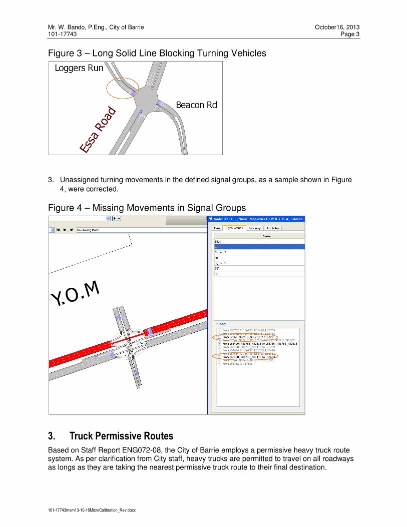
Mr. W. Bando, P.Eng., City of Barrie October16, 2013 101-17743 Page 3
101-17743mem13-10-16MicroCalibration_Rev.docx
Figure 3 – Long Solid Line Blocking Turning Vehicles
3. Unassigned turning movements in the defined signal groups, as a sample shown in Figure
4, were corrected.
Figure 4 – Missing Movements in Signal Groups
3. Truck Permissive Routes
Based on Staff Report ENG072-08, the City of Barrie employs a permissive heavy truck route system. As per clarification from City staff, heavy trucks are permitted to travel on all roadways as longs as they are taking the nearest permissive truck route to their final destination.

Mr. W. Bando, P.Eng., City of Barrie October16, 2013 101-17743 Page 4
101-17743mem13-10-16MicroCalibration_Rev.docx
However, the 2009 Model treated all the roads other than the Permissive Truck Route as prohibited truck routes throughout the whole City. Figure 5 presents a snapshot of the prohibited truck routes coded in the 2009 Model. This coding resulted in the situation that the trucks could not find a path to reach their destinations even though an OD truck demand was taken into accounts in the 2009 Model. Therefore, the prohibited truck routes coded in the 2009 Model were removed.
Figure 5 – Prohibited Truck Routes in 2009 Model
Note: The highlighted routes are the prohibited truck routes in the 2009 Model.
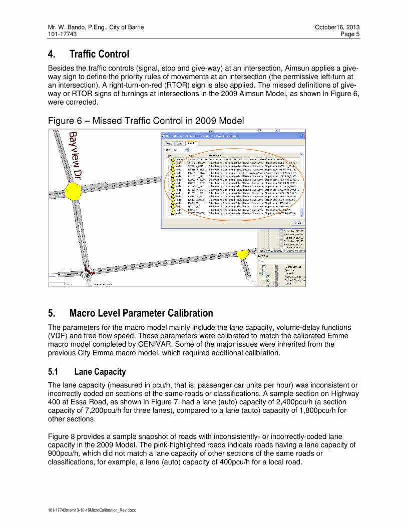
Mr. W. Bando, P.Eng., City of Barrie October16, 2013 101-17743 Page 5
101-17743mem13-10-16MicroCalibration_Rev.docx
4. Traffic Control
Besides the traffic controls (signal, stop and give-way) at an intersection, Aimsun applies a give-way sign to define the priority rules of movements at an intersection (the permissive left-turn at an intersection). A right-turn-on-red (RTOR) sign is also applied. The missed definitions of give-way or RTOR signs of turnings at intersections in the 2009 Aimsun Model, as shown in Figure 6, were corrected.
Figure 6 – Missed Traffic Control in 2009 Model
5. Macro Level Parameter Calibration
The parameters for the macro model mainly include the lane capacity, volume-delay functions (VDF) and free-flow speed. These parameters were calibrated to match the calibrated Emme macro model completed by GENIVAR. Some of the major issues were inherited from the previous City Emme macro model, which required additional calibration.
5.1 Lane Capacity
The lane capacity (measured in pcu/h, that is, passenger car units per hour) was inconsistent or incorrectly coded on sections of the same roads or classifications. A sample section on Highway 400 at Essa Road, as shown in Figure 7, had a lane (auto) capacity of 2,400pcu/h (a section capacity of 7,200pcu/h for three lanes), compared to a lane (auto) capacity of 1,800pcu/h for other sections.
Figure 8 provides a sample snapshot of roads with inconsistently- or incorrectly-coded lane capacity in the 2009 Model. The pink-highlighted roads indicate roads having a lane capacity of 900pcu/h, which did not match a lane capacity of other sections of the same roads or classifications, for example, a lane (auto) capacity of 400pcu/h for a local road.

Mr. W. Bando, P.Eng., City of Barrie October16, 2013 101-17743 Page 6
101-17743mem13-10-16MicroCalibration_Rev.docx
The inconsistent or incorrectly coded lane (auto) capacity was corrected.
Figure 7 – Incorrectly-Coded Lane Capacity on Highway 400
Figure 8 – A Snapshot of Inconsistently Coded Lane Capacity
Note: The pink-highlighted roads indicate the inconsistently- or incorrectly-coded lane capacity (having 900pcu/h) in the 2009 Model.

Mr. W. Bando, P.Eng., City of Barrie October16, 2013 101-17743 Page 7
101-17743mem13-10-16MicroCalibration_Rev.docx
It is noteworthy that the City Aimsun Model simulates both auto vehicles and trucks. The micro, meso and macro simulations share the same network and demand data. Also, the City Aimsun Model has input of origin-destination (OD) demand matrices from the City Emme Macro Model. However, the City Emme Macro Model simulates auto traffic only and lane capacity is input only for auto traffic. During the model calibration and development, a macro adjustment scenario is necessary for OD demand matrices of auto vehicles and trucks. The 2009 Aimsun Model only accounted for capacity of auto vehicles. Figure 9 presents a sample snapshot of capacity input in the 2009 Model. As shown in Figure 9, Highway 400 had a section capacity of 5,400pcu/h for a three-lane cross-section (a lane capacity of 1,800pch/h) to account for OD demand matrices of trucks as well as auto vehicles, which is inappropriate.
Figure 9 – Capacity Input in 2009 Model
Therefore, the section capacity or lane capacity was calibrated to include capacity for auto vehicles and trucks.

Mr. W. Bando, P.Eng., City of Barrie October16, 2013 101-17743 Page 8
101-17743mem13-10-16MicroCalibration_Rev.docx
5.2 Volume-Delay Functions
Volume-delay functions (VDF) were calibrated by assigned VDFs and their specifications:
1. The 2009 Model had inconsistent assigned VDFs for sections of the same road or
classification, as a sample snapshot shown in Figure 10. The inconsistent assigned VDFs
were found on both travel directions.
Figure 10 – Inconsistent Assigned VDF
Note: The red-highlighted sections have a VDF ID of 40.
2. The specifications of the VDFs (fd = 11, 13, 20 40, and 50) from the Emme Macro Model
were not correctly translated in the 2009 Aimsun Model. Figure 11 presents the VDF plots of
fd40 before and after calibration.

Mr. W. Bando, P.Eng., City of Barrie October16, 2013 101-17743 Page 9
101-17743mem13-10-16MicroCalibration_Rev.docx
Figure 11 – Incorrect Translation of VDF in 2009 Model
A) Before Calibration B) After Calibration
5.3 Speed
Inconsistent speed inputs for two travel directions of the roadways were corrected. An example is shown in Figure 12.
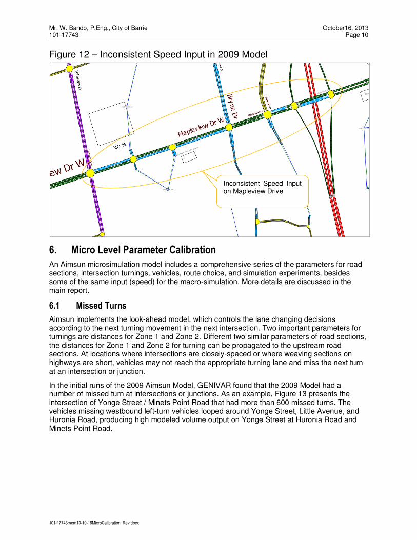
Mr. W. Bando, P.Eng., City of Barrie October16, 2013 101-17743 Page 10
101-17743mem13-10-16MicroCalibration_Rev.docx
Figure 12 – Inconsistent Speed Input in 2009 Model
6. Micro Level Parameter Calibration
An Aimsun microsimulation model includes a comprehensive series of the parameters for road sections, intersection turnings, vehicles, route choice, and simulation experiments, besides some of the same input (speed) for the macro-simulation. More details are discussed in the main report.
6.1 Missed Turns
Aimsun implements the look-ahead model, which controls the lane changing decisions according to the next turning movement in the next intersection. Two important parameters for turnings are distances for Zone 1 and Zone 2. Different two similar parameters of road sections, the distances for Zone 1 and Zone 2 for turning can be propagated to the upstream road sections. At locations where intersections are closely-spaced or where weaving sections on highways are short, vehicles may not reach the appropriate turning lane and miss the next turn at an intersection or junction.
In the initial runs of the 2009 Aimsun Model, GENIVAR found that the 2009 Model had a number of missed turn at intersections or junctions. As an example, Figure 13 presents the intersection of Yonge Street / Minets Point Road that had more than 600 missed turns. The vehicles missing westbound left-turn vehicles looped around Yonge Street, Little Avenue, and Huronia Road, producing high modeled volume output on Yonge Street at Huronia Road and Minets Point Road.
Inconsistent Speed Input on Mapleview Drive

Mr. W. Bando, P.Eng., City of Barrie October16, 2013 101-17743 Page 11
101-17743mem13-10-16MicroCalibration_Rev.docx
Figure 13 – Missed Turns in 2009 Model
Distances for Zone 1 and Zone 2 in the 2009 Model were calibrated to reduce the number of missed turns to a minimum level.
In spite of GENIVAR’s calibration efforts, a higher number of missed turns were still found as well as the following major issues regarding vehicle behaviours:
� Vehicles passed turning lanes due to no space on turning lanes resulting from the queues.
� Even if there were no queues on a turning lane, the vehicles did not make a correct turn at
an intersection where they were supposed to.
Transportation Simulation System (TSS), the Aimsun developer, confirmed on June 12, 2012 that there was a bug in the vehicle tracking system. The issue affected Aimsun 7.0.2 (the most current version) that made the vehicles move in a wrong lane to overtake a queue even if they are in Zone 2, where they should stay in the correct lane for a turn.
The model was calibrated again based on the version of Aimsun 7.0.3 (received on June 13, 2012), implementing a patch to correct this issue.


Appendix C
Model Input


Existing 2011 Traffic Demand Disaggregation Factors
Macro
EMME
Zone No. Emp. (A) Pop. (B) Zone No. Emp. © Pop. (D)
Combined
Proportion
(C+D)/(A+B)
Emp. Pop. Emp. Pop. Emp. Factor Pop. Factor
Combined
Proportion
(Delcan)
1 137 2668 1-1 137 2668 1.00 152 2963 152 2963 1.00 1.00 1.00
2 2-1 87 0 0.63 457 0 0.63 0.33 0.63
2 2-2 10 0 0.07 168 0 0.23 0.33 0.23
2 2-3 41 0 0.30 99 0 0.14 0.33 0.14
3 3-1 0 0 0.00 668 0 1.00 0.50 1.00
3 3-2 261 0 1.00 0 0 0.00 0.50 0.00
4 4-1 101 0 0.85 380 0 0.85 0.33 0.85
4 4-2 8 0 0.06 29 0 0.06 0.33 0.06
4 4-3 11 0 0.09 40 0 0.09 0.33 0.09
5 5-1 284 0 0.16 353 0 0.16 0.50 0.16
5 5-2 1514 0 0.84 1881 0 0.84 0.50 0.84
6 6-1 1754 0 0.76 2147 0 0.76 0.33 0.76
6 6-2 183 0 0.08 224 0 0.08 0.33 0.08
6 6-3 357 0 0.16 437 0 0.16 0.33 0.16
7 7-1 963 0 0.71 1238 0 0.71 0.33 0.71
7 7-2 272 0 0.20 349 0 0.20 0.33 0.20
7 7-3 121 0 0.09 156 0 0.09 0.33 0.09
15 0 780 15-1 0 780 1.00 13 878 13 878 1.00 1.00 1.00
16 393 1274 16-1 393 1274 1.00 427 1274 427 1274 1.00 1.00 1.00
17 17-1 5 0 0.04 17 0 0.04 0.25 0.04
17 17-2 0 0 0.00 0 0 0.00 0.25 0.00
17 17-3 0 0 0.00 109 0 0.26 0.25 0.26
17 17-4 107 0 0.96 297 0 0.70 0.25 0.70
18 18-1 540 0 0.43 639 0 0.43 0.25 0.43
18 18-2 182 0 0.14 216 0 0.14 0.25 0.14
18 18-3 377 0 0.30 447 0 0.30 0.25 0.30
18 18-4 157 0 0.13 187 0 0.13 0.25 0.13
19 19-1 0 0 0.00 163 0 0.21 0.25 0.21
19 19-2 112 0 0.41 240 0 0.31 0.25 0.31
19 19-3 158 0 0.58 346 0 0.45 0.25 0.45
19 19-4 4 0 0.01 14 0 0.02 0.25 0.02
20 20-1 82 0 0.97 309 0 0.96 0.50 0.97
20 20-2 3 0 0.04 11 0 0.04 0.50 0.04
21 21-1 3 0 0.01 6 0 0.01 0.50 0.01
21 21-2 590 0 0.99 1132 0 0.99 0.50 0.99
22 22-1 30 250 0.24 288 250 0.26 1.00 0.40
22 22-2 869 0 0.76 819 0 0.74 0.00 0.60
23 230 5336 23-1 230 5336 1.00 232 5336 232 5336 1.00 1.00 1.00
27 27-1 0 544 0.16 0 544 0.00 0.17 0.16
27 27-2 42 1485 0.44 42 1485 0.19 0.46 0.44
27 27-3 175 1220 0.40 175 1221 0.81 0.38 0.40
28 28-1 390 0 1.00 363 0 0.49 0.50 0.49
28 28-2 0 0 0.00 376 0 0.51 0.50 0.51
29 29-1 167 0 0.57 289 0 0.57 0.50 0.57
29 29-2 125 0 0.43 215 0 0.43 0.50 0.43
30 30-1 409 0 0.65 477 0 0.65 0.50 0.65
30 30-2 223 0 0.35 259 0 0.35 0.50 0.35
31 186 0 31-1 186 0 1.00 204 126 204 126 1.00 1.00 1.00
32 32-1 5 687 0.53 5 687 0.02 0.62 0.53
32 32-2 169 0 0.13 169 0 0.87 0.00 0.13
32 32-3 21 416 0.34 21 416 0.11 0.38 0.34
33 33-1 698 0 0.74 829 0 0.74 0.50 0.74
33 33-2 247 0 0.26 293 0 0.26 0.50 0.26
34 139 853 34-1 139 853 1.00 139 853 139 853 1.00 1.00 1.00
35 35-1 476 0 0.32 565 0 0.32 0.50 0.32
35 35-2 1001 0 0.68 1187 0 0.68 0.50 0.68
39 56 1081 39-1 56 1081 1.00 56 1392 56 1392 1.00 1.00 1.00
40 0 942 40-1 0 942 1.00 10 942 8 942 1.00 1.00 1.00
2006 2011
Micro Zones Macro-zone Micro-zoneMacro Zones
0 724 0
2294 0 2808 0
120 0 448 0
138
261 0 668 0
1356
1797 0 2234 0
0 1743 0
250899 250
593 0
1107
1138 0
1256 0 1489 0
0 320 0
112 0 423 0
274 0 763 0
85
195 1103 195 1103
632 0 736 0
1478
946 0 1122 0
0 503 0
390
217 3250 217 3250
0 1752 0
292
0 739 0
101-17743tab12-04-23Disaggregate.xlsx-2006 2012 2017 1/2

41 159 1442 41-1 159 1442 1.00 223 1445 223 1445 1.00 1.00 1.00
42 42-1 9 0 0.18 11 0 0.18 0.50 0.18
42 42-2 43 0 0.82 50 0 0.82 0.50 0.82
44 53 470 44-1 53 470 1.00 54 651 54 651 1.00 1.00 1.00
45 116 0 45-1 116 0 1.00 403 0 403 0 1.00 1.00 1.00
46 969 1322 46-1 969 1322 1.00 1151 1364 1151 1364 1.00 1.00 1.00
47 47-1 110 219 0.37 142 285 0.72 0.30 0.37
47 47-2 43 515 0.63 56 667 0.28 0.70 0.63
48 520 2202 48-1 520 2202 1.00 520 2321 520 2324 1.00 1.00 1.00
49 49-1 270 781 0.40 270 833 0.57 0.37 0.40
49 49-2 203 1351 0.60 205 1440 0.43 0.63 0.60
50 50-1 0 189 0.22 0 229 0.00 0.24 0.22
50 50-2 62 607 0.78 62 733 1.00 0.76 0.78
51 51-1 0 17 0.07 0 95 0.00 0.24 0.16
51 51-2 30 10 0.16 36 57 0.17 0.14 0.15
51 51-3 74 3 0.31 87 15 0.42 0.04 0.17
51 51-4 72 39 0.45 85 230 0.41 0.58 0.52
52 42 562 52-1 42 562 1.00 42 907 42 907 1.00 1.00 1.00
53 187 0 53-1 188 0 1.00 206 57 207 57 1.00 1.00 1.00
54 315 43 54-1 315 43 1.00 408 43 408 43 1.00 1.00 1.00
55 727 0 55-1 727 0 1.00 907 53 907 53 1.00 1.00 1.00
56 56-1 200 1392 0.37 165 1392 0.61 0.34 0.36
56 56-2 73 2325 0.55 38 2324 0.14 0.57 0.54
56 56-3 0 346 0.08 70 346 0.26 0.09 0.10
59 921 0 59-1 921 0 1.00 1469 11 1469 11 1.00 1.00 1.00
60 617 0 60-1 617 0 1.00 819 11 819 11 1.00 1.00 1.00
61 353 0 61-1 353 0 1.00 416 11 416 11 1.00 1.00 1.00
62 427 225 62-1 427 225 1.00 464 442 464 442 1.00 1.00 1.00
63 1128 0 63-1 1128 0 1.00 1245 24 1245 24 1.00 1.00 1.00
65 164 662 65-1 164 662 1.00 171 889 171 889 1.00 1.00 1.00
150 150-1 0 2056 0.21 0 2054 0.00 0.24 0.21
150 150-2 0 324 0.03 0 325 0.00 0.04 0.03
150 150-3 147 0 0.02 148 0 0.11 0.00 0.02
150 150-4 114 149 0.03 114 149 0.09 0.02 0.03
150 150-5 10 596 0.06 10 597 0.01 0.07 0.06
150 150-6 163 1595 0.18 163 1595 0.12 0.19 0.18
150 150-7 893 3684 0.47 893 3684 0.67 0.44 0.47
152 0 0 152-1 0 0 0.00 0 0 0 0 1.00 1.00 0.00
23694 40662 23694 40662 31463 43648 31463 43648
Note: 1. The population and employment control totals and their splits within the sub-zones were obtained from the 2009 Aimsun Model. The changes of the control totals
would not have any impacts on the disaggregatin factors if the allocation percentage remains the same within the sub-zones.
2. The allocation of the population and employment was consulted with the City based on the February 2010 Final Report.
1328 8404 1328 8404
177 68 208 396
273 4062 273 4062
52 0 61 0
473
62 796 62 962
2132 473 2273
153 735 198 955
101-17743tab12-04-23Disaggregate.xlsx-2006 2012 2017 2/2
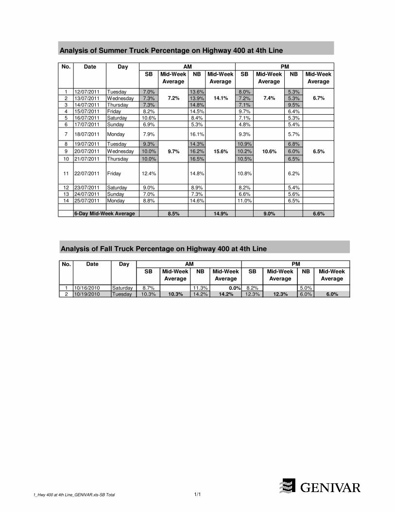
Analysis of Summer Truck Percentage on Highway 400 at 4th Line
No. Date Day
SB Mid-Week
Average
NB Mid-Week
Average
SB Mid-Week
Average
NB Mid-Week
Average
1 12/07/2011 Tuesday 7.0% 13.6% 8.0% 5.3%
2 13/07/2011 Wednesday 7.3% 13.9% 7.2% 5.3%
3 14/07/2011 Thursday 7.3% 14.8% 7.1% 9.5%
4 15/07/2011 Friday 8.2% 14.5% 9.7% 6.4%
5 16/07/2011 Saturday 10.6% 8.4% 7.1% 5.3%
6 17/07/2011 Sunday 6.9% 5.3% 4.8% 5.4%
7 18/07/2011 Monday 7.9% 16.1% 9.3% 5.7%
8 19/07/2011 Tuesday 9.3% 14.3% 10.9% 6.8%
9 20/07/2011 Wednesday 10.0% 16.2% 10.2% 6.0%
10 21/07/2011 Thursday 10.0% 16.5% 10.5% 6.5%
11 22/07/2011 Friday 12.4% 14.8% 10.8% 6.2%
12 23/07/2011 Saturday 9.0% 8.9% 8.2% 5.4%
13 24/07/2011 Sunday 7.0% 7.3% 6.6% 5.6%
14 25/07/2011 Monday 8.8% 14.6% 11.0% 6.5%
6-Day Mid-Week Average 8.5% 14.9% 9.0% 6.6%
15.6%
7.4%
10.6%
6.7%
6.5%
AM PM
14.1%7.2%
9.7%
Analysis of Fall Truck Percentage on Highway 400 at 4th Line
No. Date Day
SB Mid-Week
Average
NB Mid-Week
Average
SB Mid-Week
Average
NB Mid-Week
Average
1 10/16/2010 Saturday 8.7% 11.3% 0.0% 8.2% 5.0%
2 10/19/2010 Tuesday 10.3% 10.3% 14.2% 14.2% 12.3% 12.3% 6.0% 6.0%
AM PM
1_Hwy 400 at 4th Line_GENIVAR.xls-SB Total 1/1


No. Location and Movement Count RD (Link
Data (All))
Count Micro
Experiment
(Average 22742)
Absolute
Difference
Relative
Difference (%)
GEH
1 Mapleview / Canadian Tire_NB 48 23 -25 -52 4.22 Mapleview / Canadian Tire_WB 444 590 145 33 6.43 Mapleview / Barrieview_NB 115 234 119 103 9.04 Mapleview / Barrieview_SB 221 170 -51 -23 3.65 Mapleview / Bryne_NB 124 243 118 95 8.76 Mapleview / Bryne_SB 300 105 -195 -65 13.77 400 SB / Essa_SB 830 857 27 3 0.98 400 SB / Essa_EB 1403 1157 -246 -18 6.99 Essa / Mapleton_NB 360 400 40 11 2.1
10 Essa / Mapleton_WB 123 115 -8 -7 0.811 Essa / Gowan_NB 210 189 -21 -10 1.512 Essa / Dunn / Dyer_WB 34 26 -8 -22 1.413 Essa / Dunn / Dyer_EB 18 1 -17 -94 5.514 Huronia / Little_EB 256 210 -46 -18 3.015 Huronia / Little_WB 396 412 17 4 0.816 Huronia / Little_NB 192 164 -28 -14 2.117 Huronia / Little_SB 173 292 119 69 7.818 Minet's Point / Lakeshore_SB 57 1 -55 -98 10.319 Minet's Point / Lakeshore_NB 403 264 -139 -35 7.620 Minet's Point / Lakeshore_WB 546 438 -108 -20 4.921 Minet's Point / Lakeshore_EB 525 588 63 12 2.622 Essa / Tiffin / Bradford_WB 376 343 -33 -9 1.723 Little / Fairview_NB 312 274 -38 -12 2.224 Little / Fairview_SB 835 1025 190 23 6.225 Ferndale / Ardagh_SB 393 316 -77 -20 4.1
Existing 2011 Validation Results of Link Traffic Volumes (all Vehicles), Mid-Week AM Peak
Hour
25 Ferndale / Ardagh_SB 393 316 -77 -20 4.126 Ferndale / Ardagh_NB 365 417 52 14 2.627 Essa / Anne_WB 90 140 50 56 4.728 Essa / Anne_EB 288 434 146 51 7.729 Minet's Point / Yonge_NB 18 23 5 27 1.130 Huronia / Burton / Yonge_EB 259 389 131 50 7.331 Huronia / Burton / Yonge_WB 414 748 334 81 13.932 Huronia / Burton / Yonge_NB 161 156 -5 -3 0.433 Tiffin / Patterson_WB 518 437 -81 -16 3.734 Tiffin / Patterson_NB 314 309 -5 -2 0.335 Huronia / Big Bay Point_EB 374 279 -94 -25 5.236 Huronia / Big Bay Point_WB 603 663 60 10 2.437 Huronia / Big Bay Point_SB 232 261 29 12 1.838 Huronia / Big Bay Point_NB 267 184 -83 -31 5.539 Huronia / Lockhart_NB 240 184 -56 -23 3.940 Huronia / Lockhart_SB 269 273 5 2 0.341 Huronia / Lockhart_WB 250 242 -9 -4 0.642 Huronia / Lockhart_EB 32 12 -20 -63 4.343 Mapleview / Reid_WB 310 360 50 16 2.744 Mapleview / Reid_EB 505 539 34 7 1.545 Mapleview / Reid_NB 15 23 8 51 1.846 Ferndale / Bishop / Summerset_EB 160 56 -105 -65 10.147 Ferndale / Bishop / Summerset_WB 70 170 100 143 9.148 Ferndale / Cuthbert / Gore_WB 57 61 4 7 0.549 Ferndale / Cuthbert / Gore_EB 85 142 57 67 5.450 Tiffin / Anne_NB 307 390 83 27 4.451 Tiffin / Anne_SB 429 346 -83 -19 4.252 Tiffin / Anne_EB 465 552 87 19 3.953 Tiffin / Anne_WB 390 176 -214 -55 12.754 Tiffin / Innisfil_SB 181 85 -96 -53 8.355 Tiffin / Innisfil_NB 208 102 -106 -51 8.556 400 NB / Mapleview_NB 503 383 -121 -24 5.757 Essa / Fairview / 400 NB_NB 987 985 -2 0 0.158 400 SB / Mapleview_SB 1184 1097 -87 -7 2.6
2011AMValication_Adj-Final-Run3.xlsx-Link-AllVehicles 1/4

No. Location and Movement Count RD (Link
Data (All))
Count Micro
Experiment
(Average 22742)
Absolute
Difference
Relative
Difference (%)
GEH
Existing 2011 Validation Results of Link Traffic Volumes (all Vehicles), Mid-Week AM Peak
Hour
59 Mapleview / Huronia_SB 321 492 171 53 8.560 Mapleview / Huronia_WB 551 554 3 1 0.161 Mapleview / Huronia_NB 209 229 20 9 1.362 Mapleview / Costco driveway_NB 140 165 25 18 2.063 400 NB / Essa / carpool parking_WB 731 818 87 12 3.164 Essa / Mapleview_SB 238 319 81 34 4.865 Essa / Mapleview_WB 291 305 14 5 0.866 Essa / Mapleview_NB 249 197 -52 -21 3.567 Essa / Mapleview_EB 442 562 120 27 5.368 Ferndale / Essa / Veterans_WB 554 430 -124 -22 5.669 Ferndale / Essa / Veterans_NB 404 364 -40 -10 2.070 Ferndale / Essa / Veterans_EB 679 726 47 7 1.871 Ferndale / Essa / Veterans_SB 550 660 110 20 4.572 Essa / Mapleton_SB 462 406 -56 -12 2.773 Ferndale / Bishop / Summerset_NB 326 442 116 36 5.974 Ferndale / Bishop / Summerset_SB 308 229 -79 -26 4.875 Ferndale / Cuthbert / Gore_NB 385 520 135 35 6.376 Ferndale / Cuthbert / Gore_SB 357 227 -130 -36 7.677 Ferndale / Ardagh_WB 264 326 62 23 3.678 Ferndale / Ardagh_EB 506 521 15 3 0.679 Tiffin / Ferndale_SB 422 420 -2 -1 0.180 Tiffin / Ferndale_WB 439 363 -76 -17 3.881 Tiffin / Ferndale_EB 307 380 73 24 4.082 Essa / Dunn / Dyer_SB 261 214 -47 -18 3.183 Essa / Dunn / Dyer_NB 237 182 -55 -23 3.883 Essa / Dunn / Dyer_NB 237 182 -55 -23 3.884 Essa / Fairview / 400 NB_WB 646 758 112 17 4.285 Essa / Fairview / 400 NB_EB 1370 1322 -48 -3 1.386 Minet's Point / Yonge_EB 233 353 119 51 7.087 Minet's Point / Yonge_WB 526 548 21 4 0.988 Minet's Point / Yonge_SB 261 495 234 90 12.089 Essa / Coughlin_NB 313 315 2 1 0.190 Essa / Coughlin_SB 276 254 -22 -8 1.391 Essa / Coughlin_EB 171 222 51 30 3.692 Little / Bayview_WB 500 598 98 20 4.293 Little / Bayview_SB 256 211 -45 -18 3.094 Little / Bayview_EB 415 555 140 34 6.395 Little / Bayview_NB 202 216 14 7 0.996 Huronia / McKay_SB 273 290 18 6 1.097 400 NB / Essa / carpool parking_EB 1664 1543 -121 -7 3.098 Essa / Mapleton_EB 541 529 -12 -2 0.599 Tiffin / Ferndale_NB 474 650 176 37 7.4
100 Essa / Anne_SB 374 337 -37 -10 2.0101 Essa / Anne_NB 677 609 -68 -10 2.7102 Essa / Burton_SB 280 300 21 7 1.2103 Essa / Burton_NB 437 537 100 23 4.5104 Essa / Burton_WB 266 410 144 54 7.8105 Essa / Gowan_EB 375 432 57 15 2.9106 Essa / Gowan_WB 394 355 -39 -10 2.0107 Big Bay Point / Bayview_SB 335 299 -36 -11 2.0108 Big Bay Point / Bayview_NB 264 245 -19 -7 1.2109 Big Bay Point / Bayview_WB 547 425 -122 -22 5.6110 Big Bay Point / Bayview_EB 426 425 -1 0 0.0111 Essa / Innisfil_SB 197 244 47 24 3.2112 Essa / Innisfil_NB 170 141 -29 -17 2.3113 Essa / Innisfil_WB 361 469 108 30 5.3114 Essa / Innisfil_EB 448 402 -46 -10 2.2115 400 SB / Dunlop / Cedar Pointe_SB 424 306 -118 -28 6.2116 400 SB / Dunlop / Cedar Pointe_WB 845 1048 203 24 6.6
2011AMValication_Adj-Final-Run3.xlsx-Link-AllVehicles 2/4

No. Location and Movement Count RD (Link
Data (All))
Count Micro
Experiment
(Average 22742)
Absolute
Difference
Relative
Difference (%)
GEH
Existing 2011 Validation Results of Link Traffic Volumes (all Vehicles), Mid-Week AM Peak
Hour
117 Ferndale / Dunlop_EB 603 546 -57 -9 2.4118 Ferndale / Dunlop_WB 559 644 85 15 3.4119 Ferndale / Dunlop_NB 430 429 -2 0 0.1120 Ferndale / Dunlop_SB 641 647 6 1 0.2121 Mapleview / Barrieview_WB 996 1216 220 22 6.6122 Mapleview / Barrieview_EB 855 1230 374 44 11.6123 Mapleview / Bayview_EB 1092 1163 71 7 2.1124 Mapleview / Bayview_NB 204 220 16 8 1.1125 Mapleview / Bayview_SB 209 272 63 30 4.1126 Mapleview / Bayview_WB 550 704 154 28 6.1127 Mapleview / Bryne_WB 691 809 118 17 4.3128 Mapleview / Bryne_EB 639 927 287 45 10.3129 Mapleview / Costco driveway_SB 0 22 22 inf 6.6130 Mapleview / Costco driveway_WB 731 1042 310 42 10.4131 Mapleview / Costco driveway_EB 1077 1277 201 19 5.9132 400 NB / Mapleview_WB 1398 1114 -283 -20 8.0133 400 SB / Mapleview_EB 1378 1583 205 15 5.3134 400 NB / Mapleview_EB 1598 1692 94 6 2.3135 400 SB / Mapleview_WB 1276 1044 -232 -18 6.8136 400 NB / Dunlop_SB 322 407 85 26 4.4137 400 SB / Dunlop / Cedar Pointe_NB 472 457 -15 -3 0.7138 Highway 400 West of Essa_NB 3567 3363 -204 -6 3.5139 Highway 400 West of Essa_SB 3658 3995 337 9 5.5140 Highway 400 North of Dunlop_NB 3261 3276 15 0 0.3141 Highway 400 North of Dunlop_SB 3438 3474 36 1 0.6141 Highway 400 North of Dunlop_SB 3438 3474 36 1 0.6142 Essa / Tiffin / Bradford_NB 508 560 52 10 2.2143 Essa / Tiffin / Bradford_EB 289 193 -96 -33 6.2144 Tiffin / Lakeshore_SB 925 751 -174 -19 6.0145 Tiffin / Lakeshore_NB 290 377 87 30 4.7146 Tiffin / Lakeshore_EB 491 352 -139 -28 6.7147 Mapleview / Hollyholme Farms_WB 305 359 54 18 3.0148 Mapleview / Hollyholme Farms_EB 508 547 38 8 1.7149 Mapleview / Hollyholme Farms_SB 5 11 6 118 2.1150 Mapleview / Hollyholme Farms_NB 5 11 6 126 2.2151 Mapleview / Reid_SB 7 5 -2 -31 0.9152 Mapleview / Veterans_SB 331 639 308 93 14.0153 Mapleview / Veterans_NB 179 219 41 23 2.9154 Mapleview / Welham_EB 703 681 -22 -3 0.9155 Mapleview / Welham_WB 523 659 136 26 5.6156 Mapleview / Welham_NB 48 109 60 124 6.8157 Mapleview / Welham_SB 78 73 -5 -6 0.6158 Essa / Tiffin / Bradford_SB 279 197 -82 -29 5.3159 Mapleview / Huronia_EB 449 406 -44 -10 2.1160 Huronia / McKay_WB 125 198 73 58 5.7161 Huronia / McKay_EB 86 110 24 28 2.4162 400 NB / Essa / carpool parking_NB 252 335 83 33 4.8163 Little / Fairview_WB 546 755 209 38 8.2164 Highway 400 North of Mapleview_SB 3402 3420 17 1 0.3165 Highway 400 North of Mapleview_NB 2627 2861 234 9 4.5166 Highway 400 North of Innisfil Beach_SB 3282 3124 -157 -5 2.8167 Highway 400 North of Innisfil Beach_NB 2398 2442 44 2 0.9168 400 NB / Dunlop_EB 748 878 130 17 4.5169 400 NB / Dunlop_WB 784 863 78 10 2.7
2011AMValication_Adj-Final-Run3.xlsx-Link-AllVehicles 3/4

No. Location and Movement Count RD (Link
Data (All))
Count Micro
Experiment
(Average 22742)
Absolute
Difference
Relative
Difference (%)
GEH
Existing 2011 Validation Results of Link Traffic Volumes (all Vehicles), Mid-Week AM Peak
Hour
170 Tiffin / Patterson_EB 592 741 149 25 5.8171 Tiffin / Dyment_WB 352 318 -34 -10 1.9172 Tiffin / Dyment_SB 175 122 -53 -30 4.3173 Tiffin / Dyment_EB 662 926 264 40 9.4174 Tiffin / Innisfil_WB 343 173 -170 -50 10.6175 Tiffin / Innisfil_EB 401 313 -88 -22 4.7176 Tiffin / Lakeshore_WB 4 0 -4 -100 2.8177 Huronia / Saunders_SB 371 368 -3 -1 0.2178 Huronia / Saunders_EB 35 23 -13 -35 2.3179 Huronia / Saunders_NB 344 299 -45 -13 2.5180 Huronia / McKay_NB 168 230 62 37 4.4181 Mapleview / Veterans_WB 450 455 4 1 0.2182 Mapleview / Veterans_EB 507 548 41 8 1.8183 Mapleview / Canadian Tire_EB 705 906 201 29 7.1184 Bayview / Baldwin_SB 181 98 -83 -46 7.0185 Bayview / Baldwin_EB 160 124 -36 -23 3.0186 Bayview / Baldwin_NB 245 126 -120 -49 8.8187 Ardagh / Murrow_EB 614 429 -186 -30 8.1188 Ardagh / Murrow_WB 496 518 22 4 1.0189 Ardagh / Murrow_SB 84 31 -52 -63 6.9190 Easa btw Salem and CR-27_SB 160 187 27 17 2.0191 Easa btw Salem and CR-27_NB 109 217 108 99 8.5192 Easa btw Athabasca and Salem_SB 175 193 18 10 1.3193 Easa btw Athabasca and Salem_NB 118 183 65 55 5.3194 Veterans btw King and Salem_SB 182 171 -11 -6 0.8194 Veterans btw King and Salem_SB 182 171 -11 -6 0.8195 Veterans btw King and Salem_NB 268 204 -64 -24 4.1196 Veterans btw Salem and McKay_NB 241 221 -20 -8 1.3197 Veterans btw Salem and McKay_SB 177 201 24 13 1.7198 Veterans btw McKay and south limit_NB 179 0 -179 -100 18.9199 Veterans btw McKay and south limit_SB 168 200 32 19 2.4200 Bayview btw Saunders and Lockhart_SB 111 133 22 20 2.0201 Bayview btw Saunders and Lockhart_NB 148 114 -34 -23 3.0202 McKay btw Veterans and CR-27_WB 58 42 -16 -28 2.3203 McKay btw Veterans and CR-27_EB 51 59 8 15 1.1204 400 SB / Essa_WB 839 931 92 11 3.1205 Veterans / Harvie_EB 19 85 66 346 9.1206 Veterans / Harvie_WB 106 93 -13 -12 1.3207 Veterans / Harvie_SB 554 768 214 39 8.3208 Veterans / Harvie_NB 264 339 75 28 4.3
209 400 SB / Dunlop / Cedar Pointe_EB 948 975 28 3 0.9
Mean 504 525 21 4 4.2
Sum 105403 109691 4.1 13.1
Highway 400
Highway 400 Ramp Terminal
2011AMValication_Adj-Final-Run3.xlsx-Link-AllVehicles 4/4

No. Location and Movement Count RD
(Link Data
(All))
Count Micro
Experiment
(Average 22742)
Absolute
Difference
Relative
Difference
(%)
GEH
1 Mapleview / Canadian Tire_NB 250 104 -146 -58 11.02 Mapleview / Canadian Tire_WB 954 865 -90 -9 3.03 Mapleview / Barrieview_NB 491 235 -256 -52 13.44 Mapleview / Barrieview_SB 378 264 -114 -30 6.45 Mapleview / Bryne_NB 516 480 -36 -7 1.66 Mapleview / Bryne_SB 482 363 -119 -25 5.87 400 SB / Essa_SB 1367 962 -405 -30 11.98 400 SB / Essa_EB 1428 991 -437 -31 12.69 Essa / Mapleton_NB 389 380 -9 -2 0.5
10 Essa / Mapleton_WB 317 274 -43 -14 2.511 Essa / Gowan_NB 223 301 78 35 4.812 Huronia / Little_EB 386 289 -96 -25 5.313 Huronia / Little_WB 210 162 -48 -23 3.514 Huronia / Little_NB 370 376 6 2 0.315 Huronia / Little_SB 198 363 165 83 9.816 Minet's Point / Lakeshore_NB 529 281 -248 -47 12.317 Minet's Point / Lakeshore_WB 352 397 45 13 2.318 Minet's Point / Lakeshore_EB 880 749 -131 -15 4.619 Essa / Tiffin / Bradford_WB 287 323 36 12 2.020 Little / Fairview_NB 699 848 149 21 5.421 Little / Fairview_SB 791 822 31 4 1.122 Ferndale / Ardagh_SB 450 511 61 14 2.823 Ferndale / Ardagh_NB 588 700 112 19 4.424 Essa / Anne_WB 101 218 117 116 9.225 Essa / Anne_EB 480 432 -48 -10 2.3
Existing 2011 Validation Results of Link Traffic Volumes (all Vehicles), Mid-Week PM Peak
Hour
25 Essa / Anne_EB 480 432 -48 -10 2.326 Minet's Point / Yonge_NB 102 38 -64 -62 7.627 Huronia / Burton / Yonge_EB 595 528 -66 -11 2.828 Huronia / Burton / Yonge_WB 395 812 417 106 17.029 Huronia / Burton / Yonge_NB 285 215 -69 -24 4.430 Tiffin / Patterson_WB 726 807 81 11 2.931 Tiffin / Patterson_NB 455 481 26 6 1.232 Huronia / Big Bay Point_EB 781 741 -39 -5 1.433 Huronia / Big Bay Point_WB 525 512 -13 -2 0.634 Huronia / Big Bay Point_SB 249 357 108 43 6.235 Huronia / Big Bay Point_NB 434 385 -50 -11 2.536 Huronia / Lockhart_NB 437 429 -8 -2 0.437 Huronia / Lockhart_SB 364 412 48 13 2.538 Huronia / Lockhart_WB 150 75 -75 -50 7.139 Huronia / Lockhart_EB 205 187 -18 -9 1.340 Mapleview / Reid_WB 814 514 -300 -37 11.641 Mapleview / Reid_EB 670 652 -18 -3 0.742 Tiffin / Anne_NB 554 611 57 10 2.443 Tiffin / Anne_SB 651 684 33 5 1.344 Tiffin / Anne_EB 518 639 121 23 5.045 Tiffin / Anne_WB 392 450 58 15 2.846 Tiffin / Innisfil_SB 270 305 35 13 2.147 Tiffin / Innisfil_NB 293 328 35 12 2.048 400 NB / Mapleview_NB 1059 718 -341 -32 11.449 Essa / Fairview / 400 NB_NB 1305 1162 -143 -11 4.150 400 SB / Mapleview_SB 1258 1017 -241 -19 7.251 Mapleview / Huronia_SB 261 333 73 28 4.252 Mapleview / Huronia_WB 600 529 -71 -12 3.053 Mapleview / Huronia_NB 386 606 220 57 9.954 Mapleview / Costco driveway_NB 463 473 11 2 0.5
2011PMValication_Adj-Final-20R.xlsx-Link-AllVehicles 1/4

No. Location and Movement Count RD
(Link Data
(All))
Count Micro
Experiment
(Average 22742)
Absolute
Difference
Relative
Difference
(%)
GEH
Existing 2011 Validation Results of Link Traffic Volumes (all Vehicles), Mid-Week PM Peak
Hour
55 400 NB / Essa / carpool parking_WB 1086 1063 -23 -2 0.756 Essa / Mapleview_SB 323 531 208 64 10.057 Essa / Mapleview_WB 825 623 -202 -24 7.558 Essa / Mapleview_NB 355 374 20 6 1.059 Essa / Mapleview_EB 571 627 57 10 2.360 Ferndale / Essa / Veterans_WB 1155 1152 -3 0 0.161 Ferndale / Essa / Veterans_NB 925 991 66 7 2.162 Ferndale / Essa / Veterans_EB 575 523 -52 -9 2.263 Ferndale / Essa / Veterans_SB 505 434 -71 -14 3.364 Essa / Mapleton_SB 827 948 121 15 4.165 Ferndale / Bishop / Summerset_NB 523 724 201 38 8.166 Ferndale / Bishop / Summerset_SB 542 564 22 4 0.967 Ferndale / Cuthbert / Gore_NB 842 875 33 4 1.168 Ferndale / Cuthbert / Gore_SB 571 484 -87 -15 3.869 Ferndale / Ardagh_WB 533 654 121 23 5.070 Ferndale / Ardagh_EB 309 380 71 23 3.871 Tiffin / Ferndale_SB 596 582 -14 -2 0.672 Tiffin / Ferndale_WB 706 639 -67 -9 2.673 Tiffin / Ferndale_EB 296 391 95 32 5.174 Essa / Dunn / Dyer_SB 440 336 -104 -24 5.375 Essa / Dunn / Dyer_NB 391 313 -78 -20 4.276 Essa / Fairview / 400 NB_WB 934 928 -7 -1 0.277 Essa / Fairview / 400 NB_EB 1736 1436 -300 -17 7.578 Minet's Point / Yonge_EB 646 528 -119 -18 4.979 Minet's Point / Yonge_WB 553 588 35 6 1.479 Minet's Point / Yonge_WB 553 588 35 6 1.480 Minet's Point / Yonge_SB 501 651 150 30 6.281 Essa / Coughlin_NB 468 501 33 7 1.582 Essa / Coughlin_SB 512 758 246 48 9.883 Essa / Coughlin_EB 168 131 -37 -22 3.184 Little / Bayview_WB 333 337 4 1 0.285 Little / Bayview_SB 211 183 -28 -13 2.086 Little / Bayview_EB 379 300 -79 -21 4.387 Little / Bayview_NB 613 712 99 16 3.988 Huronia / McKay_SB 262 347 86 33 4.989 400 NB / Essa / carpool parking_EB 1846 1378 -468 -25 11.790 Essa / Mapleton_EB 402 390 -12 -3 0.691 Tiffin / Ferndale_NB 592 725 133 22 5.292 Essa / Anne_SB 601 547 -54 -9 2.393 Essa / Anne_NB 882 957 75 9 2.594 Essa / Burton_SB 517 516 -1 0 0.095 Essa / Burton_NB 598 636 38 6 1.596 Essa / Burton_WB 414 655 241 58 10.497 Essa / Gowan_EB 463 663 200 43 8.498 Essa / Gowan_WB 758 589 -168 -22 6.599 Big Bay Point / Bayview_SB 330 301 -29 -9 1.6
100 Big Bay Point / Bayview_NB 587 570 -17 -3 0.7101 Big Bay Point / Bayview_WB 597 663 66 11 2.6102 Big Bay Point / Bayview_EB 429 492 63 15 2.9103 Essa / Innisfil_SB 323 479 156 48 7.8104 Essa / Innisfil_NB 223 223 0 0 0.0105 Essa / Innisfil_WB 646 622 -24 -4 1.0106 Essa / Innisfil_EB 634 565 -69 -11 2.8107 400 SB / Dunlop / Cedar Pointe_SB 514 373 -141 -27 6.7108 400 SB / Dunlop / Cedar Pointe_WB 1188 1309 122 10 3.4109 400 SB / Dunlop / Cedar Pointe_EB 1055 798 -258 -24 8.5
2011PMValication_Adj-Final-20R.xlsx-Link-AllVehicles 2/4

No. Location and Movement Count RD
(Link Data
(All))
Count Micro
Experiment
(Average 22742)
Absolute
Difference
Relative
Difference
(%)
GEH
Existing 2011 Validation Results of Link Traffic Volumes (all Vehicles), Mid-Week PM Peak
Hour
110 Ferndale / Dunlop_EB 616 579 -37 -6 1.5111 Ferndale / Dunlop_WB 979 1013 34 3 1.1112 Ferndale / Dunlop_NB 738 468 -270 -37 11.0113 Ferndale / Dunlop_SB 621 436 -185 -30 8.0114 Mapleview / Barrieview_WB 1611 1673 62 4 1.5115 Mapleview / Barrieview_EB 1082 1509 427 39 11.9116 Mapleview / Bayview_EB 1461 1748 287 20 7.2117 Mapleview / Bayview_NB 433 433 0 0 0.0118 Mapleview / Bayview_SB 200 318 118 59 7.3119 Mapleview / Bayview_WB 700 877 177 25 6.3120 Mapleview / Bryne_WB 1179 1226 48 4 1.4121 Mapleview / Bryne_EB 856 966 109 13 3.6122 Mapleview / Costco driveway_WB 1046 1437 390 37 11.1123 Mapleview / Costco driveway_EB 1439 1770 330 23 8.2124 400 NB / Mapleview_WB 1873 1702 -171 -9 4.0125 400 SB / Mapleview_EB 2037 1799 -239 -12 5.4126 400 NB / Mapleview_EB 2402 2111 -291 -12 6.1127 400 SB / Mapleview_WB 1783 1486 -298 -17 7.4128 400 NB / Dunlop_SB 618 361 -257 -42 11.6129 400 SB / Dunlop / Cedar Pointe_NB 420 351 -69 -17 3.5130 Highway 400 West of Essa_NB 4520 4388 -132 -3 2.0131 Highway 400 West of Essa_SB 3927 3913 -14 0 0.2132 Highway 400 North of Dunlop_NB 4107 4074 -33 -1 0.5133 Highway 400 North of Dunlop_SB 3642 3754 112 3 1.8134 Essa / Tiffin / Bradford_NB 626 914 288 46 10.4134 Essa / Tiffin / Bradford_NB 626 914 288 46 10.4135 Essa / Tiffin / Bradford_EB 537 414 -123 -23 5.6136 Tiffin / Lakeshore_SB 789 725 -64 -8 2.3137 Tiffin / Lakeshore_NB 683 405 -278 -41 11.9138 Tiffin / Lakeshore_EB 776 955 179 23 6.1139 Mapleview / Hollyholme Farms_WB 831 535 -297 -36 11.4140 Mapleview / Hollyholme Farms_EB 632 632 -1 0 0.0141 Mapleview / Veterans_SB 421 536 115 27 5.2142 Mapleview / Veterans_NB 380 513 133 35 6.3143 Mapleview / Welham_EB 1140 954 -186 -16 5.7144 Mapleview / Welham_WB 572 569 -3 -1 0.1145 Mapleview / Welham_NB 159 322 163 103 10.5146 Mapleview / Welham_SB 156 226 71 46 5.1147 Essa / Tiffin / Bradford_SB 639 566 -73 -11 3.0148 Mapleview / Huronia_EB 967 699 -267 -28 9.3149 Huronia / McKay_WB 61 103 43 70 4.7150 Huronia / McKay_EB 129 399 269 208 16.6151 400 NB / Essa / carpool parking_NB 475 670 195 41 8.1152 Little / Fairview_WB 633 405 -228 -36 10.0153 Highway 400 North of Mapleview_SB 3273 2918 -355 -11 6.4154 Highway 400 North of Mapleview_NB 4253 4298 45 1 0.7155 Highway 400 North of Innisfil Beach_SB 2423 2263 -159 -7 3.3156 Highway 400 North of Innisfil Beach_NB 3797 3810 13 0 0.2157 400 NB / Dunlop_EB 851 985 134 16 4.4158 400 NB / Dunlop_WB 980 1230 250 25 7.5159 Tiffin / Patterson_EB 552 632 80 14 3.3160 Tiffin / Dyment_WB 485 812 327 67 12.8161 Tiffin / Dyment_SB 301 219 -83 -27 5.1162 Tiffin / Dyment_EB 929 987 58 6 1.9163 Tiffin / Innisfil_WB 347 401 54 15 2.8164 Tiffin / Innisfil_EB 559 597 38 7 1.6
2011PMValication_Adj-Final-20R.xlsx-Link-AllVehicles 3/4
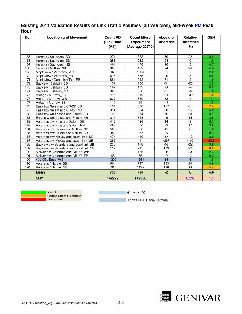
No. Location and Movement Count RD
(Link Data
(All))
Count Micro
Experiment
(Average 22742)
Absolute
Difference
Relative
Difference
(%)
GEH
Existing 2011 Validation Results of Link Traffic Volumes (all Vehicles), Mid-Week PM Peak
Hour
165 Huronia / Saunders_SB 274 333 59 22 3.4166 Huronia / Saunders_EB 258 282 24 9 1.5167 Huronia / Saunders_NB 461 476 16 3 0.7168 Huronia / McKay_NB 366 459 94 26 4.6169 Mapleview / Veterans_WB 1076 1004 -72 -7 2.2170 Mapleview / Veterans_EB 615 635 20 3 0.8171 Mapleview / Canadian Tire_EB 881 912 31 4 1.0172 Bayview / Baldwin_SB 137 106 -31 -23 2.9173 Bayview / Baldwin_EB 187 179 -8 -4 0.6174 Bayview / Baldwin_NB 326 308 -18 -6 1.0175 Ardagh / Murrow_EB 445 310 -136 -30 7.0176 Ardagh / Murrow_WB 827 860 32 4 1.1177 Ardagh / Murrow_SB 110 95 -16 -14 1.5178 Easa btw Salem and CR-27_SB 191 308 117 61 7.4179 Easa btw Salem and CR-27_NB 314 394 80 25 4.2180 Easa btw Athabasca and Salem_SB 198 254 56 28 3.7181 Easa btw Athabasca and Salem_NB 319 368 49 15 2.6182 Veterans btw King and Salem_SB 412 426 14 3 0.7183 Veterans btw King and Salem_NB 468 550 82 17 3.6184 Veterans btw Salem and McKay_NB 509 550 41 8 1.8185 Veterans btw Salem and McKay_SB 382 377 -5 -1 0.3186 Veterans btw McKay and south limit_NB 474 410 -64 -13 3.0187 Veterans btw McKay and south limit_SB 288 1 -287 -100 23.8188 Bayview btw Saunders and Lockhart_SB 230 178 -52 -22 3.6189 Bayview btw Saunders and Lockhart_NB 112 215 103 92 8.0189 Bayview btw Saunders and Lockhart_NB 112 215 103 92 8.0190 McKay btw Veterans and CR-27_WB 110 136 26 23 2.3191 McKay btw Veterans and CR-27_EB 68 66 -2 -3 0.3192 400 SB / Essa_WB 1290 1354 64 5 1.8193 Veterans / Harvie_SB 664 797 133 20 4.9
194 Veterans / Harvie_NB 1015 1195 180 18 5.4
Mean 736 734 -2 0 4.6
Sum 142777 142368 0.3% 1.1
Highway 400
Highway 400 Ramp Terminal
2011PMValication_Adj-Final-20R.xlsx-Link-AllVehicles 4/4

Appendix D
Model Validation Results

Appendix D-1
Existing 2011 Validation Results, AM Peak Hour


No. Location and Movement Count RD (Link
Data (All))
Count Micro
Experiment
(Average 22742)
Absolute
Difference
Relative
Difference (%)
GEH
1 Mapleview / Canadian Tire_NB 48 23 -25 -52 4.22 Mapleview / Canadian Tire_WB 444 590 145 33 6.43 Mapleview / Barrieview_NB 115 234 119 103 9.04 Mapleview / Barrieview_SB 221 170 -51 -23 3.65 Mapleview / Bryne_NB 124 243 118 95 8.76 Mapleview / Bryne_SB 300 105 -195 -65 13.77 400 SB / Essa_SB 830 857 27 3 0.98 400 SB / Essa_EB 1403 1157 -246 -18 6.99 Essa / Mapleton_NB 360 400 40 11 2.1
10 Essa / Mapleton_WB 123 115 -8 -7 0.811 Essa / Gowan_NB 210 189 -21 -10 1.512 Essa / Dunn / Dyer_WB 34 26 -8 -22 1.413 Essa / Dunn / Dyer_EB 18 1 -17 -94 5.514 Huronia / Little_EB 256 210 -46 -18 3.015 Huronia / Little_WB 396 412 17 4 0.816 Huronia / Little_NB 192 164 -28 -14 2.117 Huronia / Little_SB 173 292 119 69 7.818 Minet's Point / Lakeshore_SB 57 1 -55 -98 10.319 Minet's Point / Lakeshore_NB 403 264 -139 -35 7.620 Minet's Point / Lakeshore_WB 546 438 -108 -20 4.921 Minet's Point / Lakeshore_EB 525 588 63 12 2.622 Essa / Tiffin / Bradford_WB 376 343 -33 -9 1.723 Little / Fairview_NB 312 274 -38 -12 2.224 Little / Fairview_SB 835 1025 190 23 6.225 Ferndale / Ardagh_SB 393 316 -77 -20 4.1
Existing 2011 Validation Results of Link Traffic Volumes (all Vehicles), Mid-Week AM Peak
Hour
25 Ferndale / Ardagh_SB 393 316 -77 -20 4.126 Ferndale / Ardagh_NB 365 417 52 14 2.627 Essa / Anne_WB 90 140 50 56 4.728 Essa / Anne_EB 288 434 146 51 7.729 Minet's Point / Yonge_NB 18 23 5 27 1.130 Huronia / Burton / Yonge_EB 259 389 131 50 7.331 Huronia / Burton / Yonge_WB 414 748 334 81 13.932 Huronia / Burton / Yonge_NB 161 156 -5 -3 0.433 Tiffin / Patterson_WB 518 437 -81 -16 3.734 Tiffin / Patterson_NB 314 309 -5 -2 0.335 Huronia / Big Bay Point_EB 374 279 -94 -25 5.236 Huronia / Big Bay Point_WB 603 663 60 10 2.437 Huronia / Big Bay Point_SB 232 261 29 12 1.838 Huronia / Big Bay Point_NB 267 184 -83 -31 5.539 Huronia / Lockhart_NB 240 184 -56 -23 3.940 Huronia / Lockhart_SB 269 273 5 2 0.341 Huronia / Lockhart_WB 250 242 -9 -4 0.642 Huronia / Lockhart_EB 32 12 -20 -63 4.343 Mapleview / Reid_WB 310 360 50 16 2.744 Mapleview / Reid_EB 505 539 34 7 1.545 Mapleview / Reid_NB 15 23 8 51 1.846 Ferndale / Bishop / Summerset_EB 160 56 -105 -65 10.147 Ferndale / Bishop / Summerset_WB 70 170 100 143 9.148 Ferndale / Cuthbert / Gore_WB 57 61 4 7 0.549 Ferndale / Cuthbert / Gore_EB 85 142 57 67 5.450 Tiffin / Anne_NB 307 390 83 27 4.451 Tiffin / Anne_SB 429 346 -83 -19 4.252 Tiffin / Anne_EB 465 552 87 19 3.953 Tiffin / Anne_WB 390 176 -214 -55 12.754 Tiffin / Innisfil_SB 181 85 -96 -53 8.355 Tiffin / Innisfil_NB 208 102 -106 -51 8.556 400 NB / Mapleview_NB 503 383 -121 -24 5.757 Essa / Fairview / 400 NB_NB 987 985 -2 0 0.158 400 SB / Mapleview_SB 1184 1097 -87 -7 2.6
2011AMValication_Adj-Final-Run3.xlsx-Link-AllVehicles 1/4

No. Location and Movement Count RD (Link
Data (All))
Count Micro
Experiment
(Average 22742)
Absolute
Difference
Relative
Difference (%)
GEH
Existing 2011 Validation Results of Link Traffic Volumes (all Vehicles), Mid-Week AM Peak
Hour
59 Mapleview / Huronia_SB 321 492 171 53 8.560 Mapleview / Huronia_WB 551 554 3 1 0.161 Mapleview / Huronia_NB 209 229 20 9 1.362 Mapleview / Costco driveway_NB 140 165 25 18 2.063 400 NB / Essa / carpool parking_WB 731 818 87 12 3.164 Essa / Mapleview_SB 238 319 81 34 4.865 Essa / Mapleview_WB 291 305 14 5 0.866 Essa / Mapleview_NB 249 197 -52 -21 3.567 Essa / Mapleview_EB 442 562 120 27 5.368 Ferndale / Essa / Veterans_WB 554 430 -124 -22 5.669 Ferndale / Essa / Veterans_NB 404 364 -40 -10 2.070 Ferndale / Essa / Veterans_EB 679 726 47 7 1.871 Ferndale / Essa / Veterans_SB 550 660 110 20 4.572 Essa / Mapleton_SB 462 406 -56 -12 2.773 Ferndale / Bishop / Summerset_NB 326 442 116 36 5.974 Ferndale / Bishop / Summerset_SB 308 229 -79 -26 4.875 Ferndale / Cuthbert / Gore_NB 385 520 135 35 6.376 Ferndale / Cuthbert / Gore_SB 357 227 -130 -36 7.677 Ferndale / Ardagh_WB 264 326 62 23 3.678 Ferndale / Ardagh_EB 506 521 15 3 0.679 Tiffin / Ferndale_SB 422 420 -2 -1 0.180 Tiffin / Ferndale_WB 439 363 -76 -17 3.881 Tiffin / Ferndale_EB 307 380 73 24 4.082 Essa / Dunn / Dyer_SB 261 214 -47 -18 3.183 Essa / Dunn / Dyer_NB 237 182 -55 -23 3.883 Essa / Dunn / Dyer_NB 237 182 -55 -23 3.884 Essa / Fairview / 400 NB_WB 646 758 112 17 4.285 Essa / Fairview / 400 NB_EB 1370 1322 -48 -3 1.386 Minet's Point / Yonge_EB 233 353 119 51 7.087 Minet's Point / Yonge_WB 526 548 21 4 0.988 Minet's Point / Yonge_SB 261 495 234 90 12.089 Essa / Coughlin_NB 313 315 2 1 0.190 Essa / Coughlin_SB 276 254 -22 -8 1.391 Essa / Coughlin_EB 171 222 51 30 3.692 Little / Bayview_WB 500 598 98 20 4.293 Little / Bayview_SB 256 211 -45 -18 3.094 Little / Bayview_EB 415 555 140 34 6.395 Little / Bayview_NB 202 216 14 7 0.996 Huronia / McKay_SB 273 290 18 6 1.097 400 NB / Essa / carpool parking_EB 1664 1543 -121 -7 3.098 Essa / Mapleton_EB 541 529 -12 -2 0.599 Tiffin / Ferndale_NB 474 650 176 37 7.4
100 Essa / Anne_SB 374 337 -37 -10 2.0101 Essa / Anne_NB 677 609 -68 -10 2.7102 Essa / Burton_SB 280 300 21 7 1.2103 Essa / Burton_NB 437 537 100 23 4.5104 Essa / Burton_WB 266 410 144 54 7.8105 Essa / Gowan_EB 375 432 57 15 2.9106 Essa / Gowan_WB 394 355 -39 -10 2.0107 Big Bay Point / Bayview_SB 335 299 -36 -11 2.0108 Big Bay Point / Bayview_NB 264 245 -19 -7 1.2109 Big Bay Point / Bayview_WB 547 425 -122 -22 5.6110 Big Bay Point / Bayview_EB 426 425 -1 0 0.0111 Essa / Innisfil_SB 197 244 47 24 3.2112 Essa / Innisfil_NB 170 141 -29 -17 2.3113 Essa / Innisfil_WB 361 469 108 30 5.3114 Essa / Innisfil_EB 448 402 -46 -10 2.2115 400 SB / Dunlop / Cedar Pointe_SB 424 306 -118 -28 6.2116 400 SB / Dunlop / Cedar Pointe_WB 845 1048 203 24 6.6
2011AMValication_Adj-Final-Run3.xlsx-Link-AllVehicles 2/4

No. Location and Movement Count RD (Link
Data (All))
Count Micro
Experiment
(Average 22742)
Absolute
Difference
Relative
Difference (%)
GEH
Existing 2011 Validation Results of Link Traffic Volumes (all Vehicles), Mid-Week AM Peak
Hour
117 Ferndale / Dunlop_EB 603 546 -57 -9 2.4118 Ferndale / Dunlop_WB 559 644 85 15 3.4119 Ferndale / Dunlop_NB 430 429 -2 0 0.1120 Ferndale / Dunlop_SB 641 647 6 1 0.2121 Mapleview / Barrieview_WB 996 1216 220 22 6.6122 Mapleview / Barrieview_EB 855 1230 374 44 11.6123 Mapleview / Bayview_EB 1092 1163 71 7 2.1124 Mapleview / Bayview_NB 204 220 16 8 1.1125 Mapleview / Bayview_SB 209 272 63 30 4.1126 Mapleview / Bayview_WB 550 704 154 28 6.1127 Mapleview / Bryne_WB 691 809 118 17 4.3128 Mapleview / Bryne_EB 639 927 287 45 10.3129 Mapleview / Costco driveway_SB 0 22 22 inf 6.6130 Mapleview / Costco driveway_WB 731 1042 310 42 10.4131 Mapleview / Costco driveway_EB 1077 1277 201 19 5.9132 400 NB / Mapleview_WB 1398 1114 -283 -20 8.0133 400 SB / Mapleview_EB 1378 1583 205 15 5.3134 400 NB / Mapleview_EB 1598 1692 94 6 2.3135 400 SB / Mapleview_WB 1276 1044 -232 -18 6.8136 400 NB / Dunlop_SB 322 407 85 26 4.4137 400 SB / Dunlop / Cedar Pointe_NB 472 457 -15 -3 0.7138 Highway 400 West of Essa_NB 3567 3363 -204 -6 3.5139 Highway 400 West of Essa_SB 3658 3995 337 9 5.5140 Highway 400 North of Dunlop_NB 3261 3276 15 0 0.3141 Highway 400 North of Dunlop_SB 3438 3474 36 1 0.6141 Highway 400 North of Dunlop_SB 3438 3474 36 1 0.6142 Essa / Tiffin / Bradford_NB 508 560 52 10 2.2143 Essa / Tiffin / Bradford_EB 289 193 -96 -33 6.2144 Tiffin / Lakeshore_SB 925 751 -174 -19 6.0145 Tiffin / Lakeshore_NB 290 377 87 30 4.7146 Tiffin / Lakeshore_EB 491 352 -139 -28 6.7147 Mapleview / Hollyholme Farms_WB 305 359 54 18 3.0148 Mapleview / Hollyholme Farms_EB 508 547 38 8 1.7149 Mapleview / Hollyholme Farms_SB 5 11 6 118 2.1150 Mapleview / Hollyholme Farms_NB 5 11 6 126 2.2151 Mapleview / Reid_SB 7 5 -2 -31 0.9152 Mapleview / Veterans_SB 331 639 308 93 14.0153 Mapleview / Veterans_NB 179 219 41 23 2.9154 Mapleview / Welham_EB 703 681 -22 -3 0.9155 Mapleview / Welham_WB 523 659 136 26 5.6156 Mapleview / Welham_NB 48 109 60 124 6.8157 Mapleview / Welham_SB 78 73 -5 -6 0.6158 Essa / Tiffin / Bradford_SB 279 197 -82 -29 5.3159 Mapleview / Huronia_EB 449 406 -44 -10 2.1160 Huronia / McKay_WB 125 198 73 58 5.7161 Huronia / McKay_EB 86 110 24 28 2.4162 400 NB / Essa / carpool parking_NB 252 335 83 33 4.8163 Little / Fairview_WB 546 755 209 38 8.2164 Highway 400 North of Mapleview_SB 3402 3420 17 1 0.3165 Highway 400 North of Mapleview_NB 2627 2861 234 9 4.5166 Highway 400 North of Innisfil Beach_SB 3282 3124 -157 -5 2.8167 Highway 400 North of Innisfil Beach_NB 2398 2442 44 2 0.9168 400 NB / Dunlop_EB 748 878 130 17 4.5169 400 NB / Dunlop_WB 784 863 78 10 2.7
2011AMValication_Adj-Final-Run3.xlsx-Link-AllVehicles 3/4

No. Location and Movement Count RD (Link
Data (All))
Count Micro
Experiment
(Average 22742)
Absolute
Difference
Relative
Difference (%)
GEH
Existing 2011 Validation Results of Link Traffic Volumes (all Vehicles), Mid-Week AM Peak
Hour
170 Tiffin / Patterson_EB 592 741 149 25 5.8171 Tiffin / Dyment_WB 352 318 -34 -10 1.9172 Tiffin / Dyment_SB 175 122 -53 -30 4.3173 Tiffin / Dyment_EB 662 926 264 40 9.4174 Tiffin / Innisfil_WB 343 173 -170 -50 10.6175 Tiffin / Innisfil_EB 401 313 -88 -22 4.7176 Tiffin / Lakeshore_WB 4 0 -4 -100 2.8177 Huronia / Saunders_SB 371 368 -3 -1 0.2178 Huronia / Saunders_EB 35 23 -13 -35 2.3179 Huronia / Saunders_NB 344 299 -45 -13 2.5180 Huronia / McKay_NB 168 230 62 37 4.4181 Mapleview / Veterans_WB 450 455 4 1 0.2182 Mapleview / Veterans_EB 507 548 41 8 1.8183 Mapleview / Canadian Tire_EB 705 906 201 29 7.1184 Bayview / Baldwin_SB 181 98 -83 -46 7.0185 Bayview / Baldwin_EB 160 124 -36 -23 3.0186 Bayview / Baldwin_NB 245 126 -120 -49 8.8187 Ardagh / Murrow_EB 614 429 -186 -30 8.1188 Ardagh / Murrow_WB 496 518 22 4 1.0189 Ardagh / Murrow_SB 84 31 -52 -63 6.9190 Easa btw Salem and CR-27_SB 160 187 27 17 2.0191 Easa btw Salem and CR-27_NB 109 217 108 99 8.5192 Easa btw Athabasca and Salem_SB 175 193 18 10 1.3193 Easa btw Athabasca and Salem_NB 118 183 65 55 5.3194 Veterans btw King and Salem_SB 182 171 -11 -6 0.8194 Veterans btw King and Salem_SB 182 171 -11 -6 0.8195 Veterans btw King and Salem_NB 268 204 -64 -24 4.1196 Veterans btw Salem and McKay_NB 241 221 -20 -8 1.3197 Veterans btw Salem and McKay_SB 177 201 24 13 1.7198 Veterans btw McKay and south limit_NB 179 0 -179 -100 18.9199 Veterans btw McKay and south limit_SB 168 200 32 19 2.4200 Bayview btw Saunders and Lockhart_SB 111 133 22 20 2.0201 Bayview btw Saunders and Lockhart_NB 148 114 -34 -23 3.0202 McKay btw Veterans and CR-27_WB 58 42 -16 -28 2.3203 McKay btw Veterans and CR-27_EB 51 59 8 15 1.1204 400 SB / Essa_WB 839 931 92 11 3.1205 Veterans / Harvie_EB 19 85 66 346 9.1206 Veterans / Harvie_WB 106 93 -13 -12 1.3207 Veterans / Harvie_SB 554 768 214 39 8.3208 Veterans / Harvie_NB 264 339 75 28 4.3
209 400 SB / Dunlop / Cedar Pointe_EB 948 975 28 3 0.9
Mean 504 525 21 4 4.2
Sum 105403 109691 4.1 13.1
Highway 400
Highway 400 Ramp Terminal
2011AMValication_Adj-Final-Run3.xlsx-Link-AllVehicles 4/4

Appendix D-2
Existing 2011 Validation Results, PM Peak Hour


No. Location and Movement Count RD
(Link Data
(All))
Count Micro
Experiment
(Average 22742)
Absolute
Difference
Relative
Difference
(%)
GEH
1 Mapleview / Canadian Tire_NB 250 104 -146 -58 11.02 Mapleview / Canadian Tire_WB 954 865 -90 -9 3.03 Mapleview / Barrieview_NB 491 235 -256 -52 13.44 Mapleview / Barrieview_SB 378 264 -114 -30 6.45 Mapleview / Bryne_NB 516 480 -36 -7 1.66 Mapleview / Bryne_SB 482 363 -119 -25 5.87 400 SB / Essa_SB 1367 962 -405 -30 11.98 400 SB / Essa_EB 1428 991 -437 -31 12.69 Essa / Mapleton_NB 389 380 -9 -2 0.5
10 Essa / Mapleton_WB 317 274 -43 -14 2.511 Essa / Gowan_NB 223 301 78 35 4.812 Huronia / Little_EB 386 289 -96 -25 5.313 Huronia / Little_WB 210 162 -48 -23 3.514 Huronia / Little_NB 370 376 6 2 0.315 Huronia / Little_SB 198 363 165 83 9.816 Minet's Point / Lakeshore_NB 529 281 -248 -47 12.317 Minet's Point / Lakeshore_WB 352 397 45 13 2.318 Minet's Point / Lakeshore_EB 880 749 -131 -15 4.619 Essa / Tiffin / Bradford_WB 287 323 36 12 2.020 Little / Fairview_NB 699 848 149 21 5.421 Little / Fairview_SB 791 822 31 4 1.122 Ferndale / Ardagh_SB 450 511 61 14 2.823 Ferndale / Ardagh_NB 588 700 112 19 4.424 Essa / Anne_WB 101 218 117 116 9.225 Essa / Anne_EB 480 432 -48 -10 2.3
Existing 2011 Validation Results of Link Traffic Volumes (all Vehicles), Mid-Week PM Peak
Hour
25 Essa / Anne_EB 480 432 -48 -10 2.326 Minet's Point / Yonge_NB 102 38 -64 -62 7.627 Huronia / Burton / Yonge_EB 595 528 -66 -11 2.828 Huronia / Burton / Yonge_WB 395 812 417 106 17.029 Huronia / Burton / Yonge_NB 285 215 -69 -24 4.430 Tiffin / Patterson_WB 726 807 81 11 2.931 Tiffin / Patterson_NB 455 481 26 6 1.232 Huronia / Big Bay Point_EB 781 741 -39 -5 1.433 Huronia / Big Bay Point_WB 525 512 -13 -2 0.634 Huronia / Big Bay Point_SB 249 357 108 43 6.235 Huronia / Big Bay Point_NB 434 385 -50 -11 2.536 Huronia / Lockhart_NB 437 429 -8 -2 0.437 Huronia / Lockhart_SB 364 412 48 13 2.538 Huronia / Lockhart_WB 150 75 -75 -50 7.139 Huronia / Lockhart_EB 205 187 -18 -9 1.340 Mapleview / Reid_WB 814 514 -300 -37 11.641 Mapleview / Reid_EB 670 652 -18 -3 0.742 Tiffin / Anne_NB 554 611 57 10 2.443 Tiffin / Anne_SB 651 684 33 5 1.344 Tiffin / Anne_EB 518 639 121 23 5.045 Tiffin / Anne_WB 392 450 58 15 2.846 Tiffin / Innisfil_SB 270 305 35 13 2.147 Tiffin / Innisfil_NB 293 328 35 12 2.048 400 NB / Mapleview_NB 1059 718 -341 -32 11.449 Essa / Fairview / 400 NB_NB 1305 1162 -143 -11 4.150 400 SB / Mapleview_SB 1258 1017 -241 -19 7.251 Mapleview / Huronia_SB 261 333 73 28 4.252 Mapleview / Huronia_WB 600 529 -71 -12 3.053 Mapleview / Huronia_NB 386 606 220 57 9.954 Mapleview / Costco driveway_NB 463 473 11 2 0.5
2011PMValication_Adj-Final-20R.xlsx-Link-AllVehicles 1/4
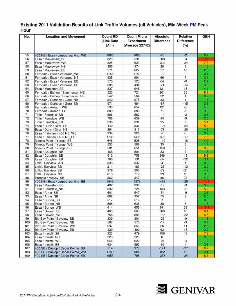
No. Location and Movement Count RD
(Link Data
(All))
Count Micro
Experiment
(Average 22742)
Absolute
Difference
Relative
Difference
(%)
GEH
Existing 2011 Validation Results of Link Traffic Volumes (all Vehicles), Mid-Week PM Peak
Hour
55 400 NB / Essa / carpool parking_WB 1086 1063 -23 -2 0.756 Essa / Mapleview_SB 323 531 208 64 10.057 Essa / Mapleview_WB 825 623 -202 -24 7.558 Essa / Mapleview_NB 355 374 20 6 1.059 Essa / Mapleview_EB 571 627 57 10 2.360 Ferndale / Essa / Veterans_WB 1155 1152 -3 0 0.161 Ferndale / Essa / Veterans_NB 925 991 66 7 2.162 Ferndale / Essa / Veterans_EB 575 523 -52 -9 2.263 Ferndale / Essa / Veterans_SB 505 434 -71 -14 3.364 Essa / Mapleton_SB 827 948 121 15 4.165 Ferndale / Bishop / Summerset_NB 523 724 201 38 8.166 Ferndale / Bishop / Summerset_SB 542 564 22 4 0.967 Ferndale / Cuthbert / Gore_NB 842 875 33 4 1.168 Ferndale / Cuthbert / Gore_SB 571 484 -87 -15 3.869 Ferndale / Ardagh_WB 533 654 121 23 5.070 Ferndale / Ardagh_EB 309 380 71 23 3.871 Tiffin / Ferndale_SB 596 582 -14 -2 0.672 Tiffin / Ferndale_WB 706 639 -67 -9 2.673 Tiffin / Ferndale_EB 296 391 95 32 5.174 Essa / Dunn / Dyer_SB 440 336 -104 -24 5.375 Essa / Dunn / Dyer_NB 391 313 -78 -20 4.276 Essa / Fairview / 400 NB_WB 934 928 -7 -1 0.277 Essa / Fairview / 400 NB_EB 1736 1436 -300 -17 7.578 Minet's Point / Yonge_EB 646 528 -119 -18 4.979 Minet's Point / Yonge_WB 553 588 35 6 1.479 Minet's Point / Yonge_WB 553 588 35 6 1.480 Minet's Point / Yonge_SB 501 651 150 30 6.281 Essa / Coughlin_NB 468 501 33 7 1.582 Essa / Coughlin_SB 512 758 246 48 9.883 Essa / Coughlin_EB 168 131 -37 -22 3.184 Little / Bayview_WB 333 337 4 1 0.285 Little / Bayview_SB 211 183 -28 -13 2.086 Little / Bayview_EB 379 300 -79 -21 4.387 Little / Bayview_NB 613 712 99 16 3.988 Huronia / McKay_SB 262 347 86 33 4.989 400 NB / Essa / carpool parking_EB 1846 1378 -468 -25 11.790 Essa / Mapleton_EB 402 390 -12 -3 0.691 Tiffin / Ferndale_NB 592 725 133 22 5.292 Essa / Anne_SB 601 547 -54 -9 2.393 Essa / Anne_NB 882 957 75 9 2.594 Essa / Burton_SB 517 516 -1 0 0.095 Essa / Burton_NB 598 636 38 6 1.596 Essa / Burton_WB 414 655 241 58 10.497 Essa / Gowan_EB 463 663 200 43 8.498 Essa / Gowan_WB 758 589 -168 -22 6.599 Big Bay Point / Bayview_SB 330 301 -29 -9 1.6
100 Big Bay Point / Bayview_NB 587 570 -17 -3 0.7101 Big Bay Point / Bayview_WB 597 663 66 11 2.6102 Big Bay Point / Bayview_EB 429 492 63 15 2.9103 Essa / Innisfil_SB 323 479 156 48 7.8104 Essa / Innisfil_NB 223 223 0 0 0.0105 Essa / Innisfil_WB 646 622 -24 -4 1.0106 Essa / Innisfil_EB 634 565 -69 -11 2.8107 400 SB / Dunlop / Cedar Pointe_SB 514 373 -141 -27 6.7108 400 SB / Dunlop / Cedar Pointe_WB 1188 1309 122 10 3.4109 400 SB / Dunlop / Cedar Pointe_EB 1055 798 -258 -24 8.5
2011PMValication_Adj-Final-20R.xlsx-Link-AllVehicles 2/4

No. Location and Movement Count RD
(Link Data
(All))
Count Micro
Experiment
(Average 22742)
Absolute
Difference
Relative
Difference
(%)
GEH
Existing 2011 Validation Results of Link Traffic Volumes (all Vehicles), Mid-Week PM Peak
Hour
110 Ferndale / Dunlop_EB 616 579 -37 -6 1.5111 Ferndale / Dunlop_WB 979 1013 34 3 1.1112 Ferndale / Dunlop_NB 738 468 -270 -37 11.0113 Ferndale / Dunlop_SB 621 436 -185 -30 8.0114 Mapleview / Barrieview_WB 1611 1673 62 4 1.5115 Mapleview / Barrieview_EB 1082 1509 427 39 11.9116 Mapleview / Bayview_EB 1461 1748 287 20 7.2117 Mapleview / Bayview_NB 433 433 0 0 0.0118 Mapleview / Bayview_SB 200 318 118 59 7.3119 Mapleview / Bayview_WB 700 877 177 25 6.3120 Mapleview / Bryne_WB 1179 1226 48 4 1.4121 Mapleview / Bryne_EB 856 966 109 13 3.6122 Mapleview / Costco driveway_WB 1046 1437 390 37 11.1123 Mapleview / Costco driveway_EB 1439 1770 330 23 8.2124 400 NB / Mapleview_WB 1873 1702 -171 -9 4.0125 400 SB / Mapleview_EB 2037 1799 -239 -12 5.4126 400 NB / Mapleview_EB 2402 2111 -291 -12 6.1127 400 SB / Mapleview_WB 1783 1486 -298 -17 7.4128 400 NB / Dunlop_SB 618 361 -257 -42 11.6129 400 SB / Dunlop / Cedar Pointe_NB 420 351 -69 -17 3.5130 Highway 400 West of Essa_NB 4520 4388 -132 -3 2.0131 Highway 400 West of Essa_SB 3927 3913 -14 0 0.2132 Highway 400 North of Dunlop_NB 4107 4074 -33 -1 0.5133 Highway 400 North of Dunlop_SB 3642 3754 112 3 1.8134 Essa / Tiffin / Bradford_NB 626 914 288 46 10.4134 Essa / Tiffin / Bradford_NB 626 914 288 46 10.4135 Essa / Tiffin / Bradford_EB 537 414 -123 -23 5.6136 Tiffin / Lakeshore_SB 789 725 -64 -8 2.3137 Tiffin / Lakeshore_NB 683 405 -278 -41 11.9138 Tiffin / Lakeshore_EB 776 955 179 23 6.1139 Mapleview / Hollyholme Farms_WB 831 535 -297 -36 11.4140 Mapleview / Hollyholme Farms_EB 632 632 -1 0 0.0141 Mapleview / Veterans_SB 421 536 115 27 5.2142 Mapleview / Veterans_NB 380 513 133 35 6.3143 Mapleview / Welham_EB 1140 954 -186 -16 5.7144 Mapleview / Welham_WB 572 569 -3 -1 0.1145 Mapleview / Welham_NB 159 322 163 103 10.5146 Mapleview / Welham_SB 156 226 71 46 5.1147 Essa / Tiffin / Bradford_SB 639 566 -73 -11 3.0148 Mapleview / Huronia_EB 967 699 -267 -28 9.3149 Huronia / McKay_WB 61 103 43 70 4.7150 Huronia / McKay_EB 129 399 269 208 16.6151 400 NB / Essa / carpool parking_NB 475 670 195 41 8.1152 Little / Fairview_WB 633 405 -228 -36 10.0153 Highway 400 North of Mapleview_SB 3273 2918 -355 -11 6.4154 Highway 400 North of Mapleview_NB 4253 4298 45 1 0.7155 Highway 400 North of Innisfil Beach_SB 2423 2263 -159 -7 3.3156 Highway 400 North of Innisfil Beach_NB 3797 3810 13 0 0.2157 400 NB / Dunlop_EB 851 985 134 16 4.4158 400 NB / Dunlop_WB 980 1230 250 25 7.5159 Tiffin / Patterson_EB 552 632 80 14 3.3160 Tiffin / Dyment_WB 485 812 327 67 12.8161 Tiffin / Dyment_SB 301 219 -83 -27 5.1162 Tiffin / Dyment_EB 929 987 58 6 1.9163 Tiffin / Innisfil_WB 347 401 54 15 2.8164 Tiffin / Innisfil_EB 559 597 38 7 1.6
2011PMValication_Adj-Final-20R.xlsx-Link-AllVehicles 3/4

No. Location and Movement Count RD
(Link Data
(All))
Count Micro
Experiment
(Average 22742)
Absolute
Difference
Relative
Difference
(%)
GEH
Existing 2011 Validation Results of Link Traffic Volumes (all Vehicles), Mid-Week PM Peak
Hour
165 Huronia / Saunders_SB 274 333 59 22 3.4166 Huronia / Saunders_EB 258 282 24 9 1.5167 Huronia / Saunders_NB 461 476 16 3 0.7168 Huronia / McKay_NB 366 459 94 26 4.6169 Mapleview / Veterans_WB 1076 1004 -72 -7 2.2170 Mapleview / Veterans_EB 615 635 20 3 0.8171 Mapleview / Canadian Tire_EB 881 912 31 4 1.0172 Bayview / Baldwin_SB 137 106 -31 -23 2.9173 Bayview / Baldwin_EB 187 179 -8 -4 0.6174 Bayview / Baldwin_NB 326 308 -18 -6 1.0175 Ardagh / Murrow_EB 445 310 -136 -30 7.0176 Ardagh / Murrow_WB 827 860 32 4 1.1177 Ardagh / Murrow_SB 110 95 -16 -14 1.5178 Easa btw Salem and CR-27_SB 191 308 117 61 7.4179 Easa btw Salem and CR-27_NB 314 394 80 25 4.2180 Easa btw Athabasca and Salem_SB 198 254 56 28 3.7181 Easa btw Athabasca and Salem_NB 319 368 49 15 2.6182 Veterans btw King and Salem_SB 412 426 14 3 0.7183 Veterans btw King and Salem_NB 468 550 82 17 3.6184 Veterans btw Salem and McKay_NB 509 550 41 8 1.8185 Veterans btw Salem and McKay_SB 382 377 -5 -1 0.3186 Veterans btw McKay and south limit_NB 474 410 -64 -13 3.0187 Veterans btw McKay and south limit_SB 288 1 -287 -100 23.8188 Bayview btw Saunders and Lockhart_SB 230 178 -52 -22 3.6189 Bayview btw Saunders and Lockhart_NB 112 215 103 92 8.0189 Bayview btw Saunders and Lockhart_NB 112 215 103 92 8.0190 McKay btw Veterans and CR-27_WB 110 136 26 23 2.3191 McKay btw Veterans and CR-27_EB 68 66 -2 -3 0.3192 400 SB / Essa_WB 1290 1354 64 5 1.8193 Veterans / Harvie_SB 664 797 133 20 4.9
194 Veterans / Harvie_NB 1015 1195 180 18 5.4
Mean 736 734 -2 0 4.6
Sum 142777 142368 0.3% 1.1
Highway 400
Highway 400 Ramp Terminal
2011PMValication_Adj-Final-20R.xlsx-Link-AllVehicles 4/4