100 years what made the largest geoid anomaly in the world
TRANSCRIPT

100 YEARS
Time to Take a Hard Lookat Geoengineering
How to Keep Rivers Flowing When Dams
Are in Demand
What Made the LargestGeoid Anomaly
in the World?
THE (NEW) SCIENCE OFAPOLLO
VOL. 100 • NO. 7 • JULY 2019

AGU AdvancesPremier Gold open access journal for influential Earth and space science research.
Presubmission inquiries are welcomed at [email protected].

Earth & Space Science News Eos.org // 1
©2019. AGU. All Rights Reserved. Material in this issue may be photocopied by individual scientists for research or classroom use. Permission is also granted to use short quotes, fi gures, and tables for publication in scientifi c books and journals. For permission for any other uses, contact the AGU Publications Offi ce.
Eos (ISSN 0096-3941) is published monthly by AGU, 2000 Florida Ave., NW, Washington, DC 20009, USA. Periodical Class postage paid at Washington, D.C., and at additional mailing offi ces. POSTMASTER: Send address changes to Member Service Center, 2000 Florida Ave., NW, Washington, DC 20009, USA.
Member Service Center: 8:00 a.m.–6:00 p.m. Eastern time; Tel: +1-202-462-6900; Fax: +1-202-328-0566; Tel. orders in U.S.: 1-800-966-2481; [email protected].
Use AGU’s Geophysical Electronic Manuscript Submissions system to submit a manuscript: eos-submit.agu.org.
Views expressed in this publication do not necessarily refl ect offi cial positions of AGU unless expressly stated.
Christine W. McEntee, Executive Director/CEO
Editor in Chief Heather Goss, AGU, Washington, D.C., USA; [email protected]
Editorial
Production & Design
Manager, News and Features EditorSenior News Writer
News Writer and Production AssociateNews and Production Fellow
Caryl-Sue MicalizioRandy ShowstackKimberly M. S. CartierJenessa Duncombe
Manager, Production and OperationsSenior Production Specialist
Editorial and Production CoordinatorAssistant Director, Design & Branding
Senior Graphic Designer
Faith A. IshiiMelissa A. TriburLiz CastensonBeth BagleyValerie Friedman
Science AdvisersAtmospheric Sciences
Space Physics and AeronomyBiogeosciences
Study of the Earth’s Deep Interior Hydrology
GeodesyHistory of Geophysics
Planetary SciencesNatural Hazards
Volcanology, Geochemistry, and Petrology Seismology
Geomagnetism, Paleomagnetism, and Electromagnetism
TectonophysicsNear-Surface Geophysics
Earth and Space Science InformaticsPaleoceanography and Paleoclimatology
Mineral and Rock PhysicsOcean Sciences
Cryosphere SciencesGlobal Environmental Change
EducationTectonophysics
Nonlinear GeophysicsEarth and Planetary Surface Processes
Atmospheric and Space ElectricitySocietal Impacts and Policy Sciences
Mark G. FlannerNicola J. FoxSteve FrolkingEdward J. GarneroMichael N. Gooseff Brian C. GunterKristine C. HarperSarah M. HörstSusan E. HoughEmily R. JohnsonKeith D. KoperRobert E. Kopp
Jian LinJuan LorenzoKirk MartinezFigen MekikSébastien MerkelJerry L. MillerThomas H. PainterPhilip J. RaschEric M. RiggsCarol SteinAdrian TuckAndrew C. WilcoxEarle WilliamsMary Lou Zoback
MarketingDirector, Marketing, Branding & AdvertisingAssistant Director, Marketing & Advertising
Marketing Program ManagerSenior Specialist, Digital Marketing
Digital Marketing Coordinator
Jessica LattermanLiz ZipseAngelo Bouselli Nathaniel Janick Ashwini Yelamanchili
AdvertisingDisplay Advertising
Recruitment Advertising
Heather [email protected]
FROM THE EDITOR
Spacecraft 107’s Big Trip
S cribbled in ballpoint pen on an equip-ment bay panel in pilot Michael Col-lins’s handwriting are the words
Spacecraft 107, alias Apollo 11, alias “Columbia.”The Best Ship to Come Down the Line.
For all that we celebrate the feat of engi-neering of the first Moon landing, it hits us hardest when we remember how human it all was.
If it’s hard to imagine walking on the Moon, we can easily imagine Collins’s immense pride as he rode the USS Hornet to Hawaii after splashdown, uncapping his pen to leave behind a mark that commemorated this wild mission. (Technology later revealed that it was twice the pride: Three-dimensional imaging of Columbia, Apollo 11’s command module, by the Smithsonian Institution in 2016 revealed that Collins had come back to the ship later, likely while he was in quarantine at the Johnson Space Center, and had written over his note again to preserve it.)
AGU has the honor of celebrati ng the fifti-eth anniversary of the first Moon landing along with our own Centennial. Join us at the National Archives in Washington, D.C., later this month, when AGU will be sponsoring a geology panel discussion followed by a screen-ing of the 2019 documentary Apollo 11—we’ll relive the excitement of that day through footage newly found and digitized by Archives researchers.
We also celebrate the legacy of Apollo in the pages of Eos. Our cover story (p. 20) looks at the science that came out of the 382 kilograms of Moon rocks hauled back by the astronauts. As recently as this past January, scientists announced a new discovery from the Apollo 14 mission (p. 4) zircon grains common to Earth but unique to the Moon—which is to say, lunar-roving astronauts may have brought back an Earth meteorite!
NASA researchers had the foresight not to put all these alien treasures under the micro-scope as soon as they got their hands on them—a portion was held back and protected from our atmosphere so that today’s scientists could use modern technology on untouched specimens. We know we’re not alone in our excitement at what they might discover about our closest planetary neighbor.
While we reflect on how those space missions changed so much about the way we view our place in the universe, we con-tinue to be inspired by new opportunities for exploration. Telepresence, wherein astronauts in orbit around the Moon or Mars would guide robots on the ground, is shaping up to be the next big thing in space exploration. Mean-while, experts here on Earth are first guiding this technology underground. On p. 30, read about a team testing robots that can autono-mously navigate through flooded mines. The idea is less romantic, perhaps—there’s no one to call back that the Eagle has landed—but sending in robots to such treacherously dan-gerous terrain is likely the best way to keep pushing our boundaries of exploration.
Our forays into space technology have led us to new adventures on Earth as well. Geoid anomaly maps created by satellite observa-tions have revealed strangeness in the Indian Ocean. On p. 26, read about the Indian research team that is on the hunt for the “missing mass” that will explain the largest geoid anomaly in the world. Theories abound: Is the anomaly due to structural undulation in the core–mantle boundary? Seismic low- velocity anomalies in the upper mantle? A “slab graveyard” in the lower mantle? To find out, the team headed to the source and deployed seismic sensors to record data for a year. We eagerly await their results.
Behind all science is the excitement of exploration and the thrill of discovery. In every issue, Eos dedicates its final page to such adventurers with Postcards from the Field. This month we hear from a team hand- digging paleoseismic trenches in the Teton Range.
We urge you all to keep exploring, keep dis-covering—and send us a postcard!
Heather Goss, Editor in Chief

2 // Eos July 2019
CONTENTS
Cover Story
Features
30
20
26
20 Apollo’s Legacy: 50 Years of Lunar GeologyBy Kimberly M. S. Cartier
Samples of the Moon’s surface brought back by Apollo astronauts ushered in a new era of planetary science. Scientists today continue the legacy.
On the CoverApollo 11 sample 10019, a brecciated rock.Credit: NASA/Johnson Space Center/Lunar and Planetary Institute
26 Seismologists Search for the Indian Ocean’s “Missing Mass”By Lachit S. Ningthoujam et al.
The first expedition of its kind aims to unravel the source of the largest geoid anomaly in the world.
30 Robots UndergroundBy Adityarup Chakravorty
From exploring flooded sites to providing alerts, robotics is changing the mining industry.
Earth & Space Science News Eos.org // 3
NEWS
AmericanGeophysicalUnion company/american-geophysical-union@AGU_Eos AGUvideos americangeophysicalunion americangeophysicalunion
Columns
CONTENTS
148
From the Editor 1 Spacecraft 107’s Big Trip
News 4 Apollo May Have Found an Earth Meteorite
on the Moon 6 Climate Geoengineering Study Will Examine Risks
and Benefits 8 Passing Object May Have Kicked Up Dust
from a Planetary Disk 9 The Blob Causing Earthquakes 10 Where Did All the Free- Flowing Rivers Go? 11 Airborne Gravity Surveys Are Remaking
the U.S. Elevation Map 13 A Wildlife Corridors System to Protect Species 14 Tree Rings Record 19th- Century Anthropogenic
Climate Change
Opinion 15 Science in This Century Needs People 18 Caregiver Awards Support Early-Career Researchers
AGU News 35 AGU Honored with the First Clean Energy DC Award 36 In Appreciation of AGU’s Outstanding Reviewers of 2018
Research Spotlight 47 Models Show Radiation Damage to Astronauts
in Real Time 48 New Analysis Provides a Fresh View of the Atmosphere
on Venus 48 Can Patches of Cold Air Cause Thunderstorms
to Cluster? 49 The Accidental Particle Accelerator Orbiting Mars
Positions Available 50 Current job openings in the Earth and space sciences
Postcards from the Field 53 A message from researchers in a paleoseismic trench in
Wyoming’s Teton Range.

4 // Eos July 2019
NEWSNEWS
Apollo May Have Found an Earth Meteorite on the Moon
A rock sample brought back by Apollo 14 may contain the first evidence of Earth material on the Moon. Recent
analysis of zircon grains in one lunar sample suggests that the zircon formed under condi-tions typical in Earth’s crust and not on the Moon.
“We have searched in a lot of Apollo rocks,” said Jeremy Bellucci. “In theory, this is the first and only piece of Earth we have found outside of Earth.” Bellucci is a geochemist in the Department of Geosciences at the Swedish Museum of Natural History in Stockholm and lead author on a research paper (bit.ly/ zircon - apollo) that presented these results in Janu-ary.
The geochemistry and crystallization envi-ronment of the two zircon grains would be “unique to the Moon yet common to Earth,” the team wrote in its paper. If the zircons’ ori-gin is verified, these grains would be some of the oldest Earth minerals discovered to date and would give a new look into Earth’s hellish early years.
Two Old ZirconsThe Apollo 14 astronauts landed on the Moon in 1971 and collected nearly 43 kilograms of lunar material that they brought back to Earth. Scientists have been studying these Moon rocks for decades to learn more about the Moon’s minerology, geochemistry, impact history, and magnetic environment.
One sample the astronauts returned with was cataloged as 14321, a 9- kilogram boulder nicknamed “Big Bertha.” Cutting into this boulder revealed a clast of granite that con-tained two zircon grains in a complex breccia. Zircons serve as an important paleoarchive on Earth, recording the time, temperature, pressure, and geochemistry at the time they formed. The oldest zircons, those from Jack Hills, Australia, may be nearly 4.4 billion years old.
Past studies have shown that these two lunar zircons are about 4.1 billion years old and formed during a tumultuous time in the solar system’s history called the Late Heavy Bombardment. Scientists think that Big Ber-
tha, along with the other samples col-lected during Apollo 14, is lunar debris from an impact that formed Mare Imbrium. But Bellucci and his team believe that the two zircons were born even farther away.
A Lot of Weird ThingsThe researchers ana-lyzed the geochem-istry of the zircons and the surrounding breccia to determine their formation environment. They calculated the crys-tallization pressure by measuring the concentration of titanium in the zir-cons and in breccia grains with an ion mass spectrometer. On the basis of this measurement, the
team found that the crystallization pressure translated to a depth of about 170 kilometers below the Moon’s surface.
Bellucci and his team then simulated how deeply the Imbrium impact would have exca-vated the Moon’s surface. Their models sug-gest that material from the base of the lunar crust, about 30– 70 kilometers deep, was ejected from the crater. This depth is far shallower than that where the zircons would have crystallized had they formed on the Moon, the team noted.
On Earth, however, the crystallization pressure corresponds to about 20 kilometers deep in Earth’s crust, a region that easily might have been excavated by an impact, Bellucci said.
Next, the team measured the concentration of oxidized cerium ions in the two zircon grains. This measurement was used as a proxy for the amount of freely available oxygen at the time the zircons crystallized. The cerium measurements showed that the zircons crys-tallized in an oxygen- rich and possibly water rich environment that would be unusual for the Moon but common in Earth’s crust.
The cerium measurements also revealed that the zircons crystallized at a temperature much lower than for other lunar magmas and is more in line with shallow- crust minerals on Earth.
“A lot of weird things happened in this clast where these zircons came from” if they came from the Moon, Bellucci said. The brec-cia that surrounds the zircons, however, has Moon- like geochemistry.
The Moon or Earth?Nevertheless, the researchers considered whether the sample could have formed
The zircons crystallized in an oxygen- rich and possibly water rich environment that would be unusual for the Moon but common in Earth’s crust.
The Apollo 14 landing site as seen by the Lunar Reconnaissance Orbiter on 25 January
2011. The descent module landing site is seen as a dark spot northwest of the three cra-
ters at bottom left in this image. A faint dark trail from the landing site to nearby Cone
crater (top right) marks the path of the astronauts’ exploration of Fra Mauro. Credit:
NASA/GSFC/Arizona State University

Earth & Space Science News Eos.org // 5
NEWS
entirely on the Moon near Mare Imbrium. The Imbrium impact then would have ejected the clast to its eventual home at the Apollo 14 landing site. In this scenario, a shock wave associated with the impact would provide the higher crystallization pressure. However, the shock wave also would have left behind other signs in the grains that are notably absent, the team said.
But if the zircons formed in Earth’s crust during the Hadean (>4.0 billion years ago), that would explain the low-temperature, high-pressure, and high-oxidation environ-ment in which the zircons crystallized, Bel-lucci’s team argues. An impact on Earth might have ejected the material to the Moon, some of which then mixed with lunar mate-rial. This mixing would explain why some of the sample’s grains suggest a lunar origin while the zircons suggest a terrestrial one, Bellucci explained.
“We have no rocks on Earth that are older than about 4 billion years,” Bellucci said. “Most of the material from before 4 billion years ago are the zircons from Jack Hills. If the Moon has pieces of Earth that arrived there during the Late Heavy Bombardment, they must have formed before 3.9 billion years ago.”
“[The Moon] could serve as an inventory to study the Hadean Earth, which we don’t have any pieces of anymore on Earth,” he added.
First of Its KindThe results are “very intriguing,” accord-ing to Carolyn Crow, a research associate in geological sciences at the University of Colorado Boulder who was not involved with this research. “These zircons do appear to have more Earth- like trace element compositions relative to the rest of the Apollo zircons,” she told Eos.
However, Crow cautioned that some of the team’s assumptions—particularly that the zircon, quartz, and other minerals in the brec-cia crystallized at the same time—still need to be verified. If the assumption is false, that could rule out Earth as an origin. “That being said,” she continued, “if further work is able to confirm that this assumption holds true,
then this would be compelling evidence for a terrestrial meteorite on the Moon.”
“I expect there could be a bit of controversy because this is the first of its kind,” Bellucci said. “Hopefully, it inspires a search for more Earth materials and further analyses on these samples.”
By Kimberly M. S. Cartier (@AstroKimCartier), Staff Writer
Backscatter electron images of two zircons (Zr) from Apollo sample 14321. The zircons
are surrounded by potassium feldspar (Ksp), iron- infused melt glass (melt), pyroxene
(Px), and quartz (Qtz). Credit: Bellucci et al., 2019, https:// doi . org/10 . 1016/ j.epsl .2019 .01
.010, Figure 1
Apollo 14 sample 14321, nicknamed “Big Bertha.” Credit: NASA/Johnson Space Center
photograph S71- 29184
Get Eos highlights in your inbox every Friday.Visit bit.ly/Eos_Buzz to sign up for the Eos Buzz newsletter.

6 // Eos
NEWSNEWS
July 2019
W ith growing concerns about the impacts of climate change, a new study is examining whether contro-
versial geoengineering approaches to try to cool Earth should be considered along with mitigation, adaptation to unavoidable climate change impacts, and other measures.
A committee of the U.S. National Academies of Sciences, Engineering, and Medicine (NASEM) has started developing a research agenda and exploring approaches for climate intervention (CI) strategies to cool Earth.
The committee, which held its first meeting on 30 April, is looking into sunlight reflection strategies that involve atmospheric interven-tions, according to the committee’s statement of task. These strategies include marine cloud brightening, stratospheric aerosol injection, and cirrus cloud modification.
The committee will examine the positive and negative impacts and risks of these inter-ventions on the atmosphere, climate systems, natural and managed ecosystems, and human systems, and explore what research and infra-structures are needed, according to the state-ment.
Though these interventions could reduce some risks of climate change, they also intro-duce potential environmental, ethical, social, political, economic, and legal risks—and con-cerns about these risks have constrained research on the topic.
How Do You Balance the Risks?How to balance the risks from climate change against the potential risks from possible solar climate interventions “is a really hard ques-tion,” committee cochair Christopher Field told Eos.
“That’s part of the reason that we would want to understand much more about the potential of the interventions and their risks before even having any kind of serious discus-sion about whether they should be included in a portfolio of responses” to climate change, said Field, a climate scientist who is director of the Stanford Woods Institute for the Environ-ment at Stanford University in California. “We are just way too early in the development of the dialogue to have a mature response to that.”
The committee also plans to look into gov-ernance mechanisms that could encourage public participation and consultation in research planning and oversight and that
could ensure transparency and accountability about a project, including a project’s potential risks.
The Right Timing for a Study“We think the timing is right for a compre-hensive study, such as the one that the National Academy of Science (NAS) completed in 2015, given the increasing interest in this issue and large remaining uncertainties in both the scientific and governance arenas,” according to a statement by the National Oce-anic and Atmospheric Administration (NOAA), one of the study’s sponsors. David Fahey, director of the Chemical Sciences Division of NOAA’s Earth System Research Laboratory in
Boulder, Colo., presented the statement at the meeting.
However, the statement continued, “our support for this study should not be inter-preted as reflecting support for future imple-mentation of [climate intervention] methods to reflect sunlight.”
Fahey noted that the committee’s work could help to guide NOAA’s efforts. “There is no federal program for geoengineering,” although there is a lot of research relevant to geoengineering, he said. “The elephant in the room here is urgency,” Fahey continued. “Urgency tends to override all of these nicer considerations about ‘should we do it’ and ‘what about the balance of risks.’”
Taking a Hard Look at All Possible Approaches“There are real risks that we may not get there in terms of limiting dangerous climate change only through the technologies that many of us prefer,” committee member Peter Frumhoff told Eos. “From my perspective, solar geoengineering is the worst possible way to address climate change that we need to take seriously.” Frumhoff is director of
Climate Geoengineering Study Will Examine Risks and Benefits
A committee of the U.S. National Academies of Sciences, Engineering, and Medicine has started working on developing
a research agenda for climate intervention strategies that reflect sunlight to cool Earth. Credit: iStock.com/modestbike
“Solar geoengineering is the worst possible way to address climate change that we need to take seriously.”

Eos.org // 7
NEWS
Earth & Space Science News
science and policy and chief climate scientist at the nonprofit Union of Concerned Scien-tists.
“We are no longer at the point in time when, from my perspective, we can avoid taking a hard look at all possible approaches, even those we don’t love, and we may ulti-mately reject them,” he said.
Frumhoff added that discussion about cli-mate interventions should not be driven by scientists but should involve a variety of stakeholders, including the most climate- vulnerable nations and communities.
Stakeholder Perspectives“We view the sunlight reflection techniques as currently among the most high probability options for short- acting solutions to disrup-tive change. They may be very important in that regard from the point of view of protect-ing people, ecosystems, and economic sys-tems” from the threat of climate change, said Kelly Wanser, executive director of SilverLining, a Washington, D.C.–based non-profit whose mission is to drive research to improve the ability to forecast climate and
understand the risks and feasibility of inter-ventions to reduce warming.
Janos Pasztor, executive director of the Car-negie Climate Geoengineering Governance Initiative of the Carnegie Council for Ethics in International Affairs, emphasized that research on solar radiation management “should not be considered to be an alternative to research on, and implementation of, emis-sion reductions and renewables.”
“The committee should recognize and acknowledge the strong and very widespread opposition to these forms of geoengineering within civil society and social movements across the world,” said Lili Fuhr, another speaker at the meeting. Fuhr is head of the Ecology and Sustainable Development Depart-ment of the Heinrich Böll Foundation, a non-profit affiliated with, but independent of, the German Green Party.
What We Don’t KnowAndrew Light, a professor of philosophy, pub-lic policy, and atmospheric sciences at George Mason University and a senior fellow in the climate program at the nonprofit World Resources Institute, told Eos that he doesn’t know anybody in the research community who seriously imagines that climate interven-tions would be a substitute for climate mitiga-tion.
“But the fact of the matter is that we know enough now about how quickly the climate is changing and how bad the impacts are going to be if we don’t meet some of the interna-tionally agreed upon targets that we have right now, that we have to consider whether this [climate intervention] is possible,” Light said. “I would like to know what we don’t know about these kinds of proposals, which have been around for decades. We can’t afford to take anything off the table,” he added.
By Randy Showstack (@RandyShowstack), Staff Writer
“We can’t afford to take anything off the table.”
Read it first on Green and Grand: John Wesley Powell and the West That Wasn’t bit.ly/Eos_Powell
Hiroshima Bomb Created Asteroid Impact–Like Glass bit.ly/Eos_Hiroshima-glass
Mapping Subglacial Meltwater Channels bit.ly/Eos_meltwater-channels
Monitoring Haiti’s Quakes with Raspberry Shake bit.ly/Eos_haiti-quakes
Deciphering the Fate of Plunging Tectonic Plates in Borneo bit.ly/Eos_tectonic-plates
Pacific Carbon Uptake Accelerating Faster Than Expected bit.ly/Eos_carbon-uptake
Articles are published on Eos.org before they appear in the magazine.
Visit eos.org daily for the latest news and perspectives.

8 // Eos July 2019
NEWSNEWS
A protoplanetary disk in a rare configu-ration is providing insights into how passing objects may influence the way
planets form.Surrounding the star SU Aurigae, the proto-
planetary disk features an extended tail of gas and dust. New research suggests that the tail most likely formed as a result of a flyby from a substellar object, which dragged out some of the gas and dust from the disk. Interactions between disks and passing objects may help to explain the wide variety of planetary systems spotted around other stars, according to research recently published in the Astronomical Journal ( bit .ly/ protoplanetary -disk -tail).
Stars form when a cloud of gas and dust col-lapses in on itself. After a star is born, leftover material can spin into a disk that can go on to build planets. Passing stars, clouds of gas, and even giant planets can gravitationally collide with the young disk, shaking up how young planets evolve.
“If the collision occurs during planet for-mation, the orbits of [the young] planets are scattered drastically,” says Eiji Akiyama, an astronomer at Japan’s Hokkaido University
and the lead author of the new research. “Some of them could be pushed out from the planetary system and exist as free- floating planets.”
Tracking Down the TailAkiyama and his colleagues had previously studied SU Aurigae with the Subaru Telescope on top of Hawaii’s Mauna Kea. They found that the young disk had a small tail of dust that extends approximately 350 astronomical units (AU), where 1 AU is the distance between Earth and the Sun. The discovery piqued their inter-est, and they decided to probe the disk again with the Atacama Large Millimeter/submilli-meter Array (ALMA) in Chile to better under-stand the unusual feature. ALMA revealed an even longer, gas-filled tail that stretched more than 1,000 AU.
The most likely candidate for creating the tail is a passing substellar object, according to the authors. As a brown dwarf or giant planet zipped by the newborn star, material in the outskirts of the disk would have felt a stronger gravitational pull from the interloper than from its sun. According to Akiyama, the sub-
stellar object would have made its pass only a few hundred years ago, an eyeblink in astro-nomical timescales.
Although it’s possible that the tail could have been formed by a planet ejected from the disk itself, the authors think that scenario is unlikely because the motion of the tail appears to argue against it. Objects from inside the disk would continue to rotate around the star, cre-ating a curved tail that would wrap around it. Instead, the tail stretches away from the star.
The tail is “almost running away from [the star],” says Joseph Rodriguez, an astronomer at the Harvard- Smithsonian Center for Astro-physics not involved in the research. Like
breadcrumbs, the escaping tail could indicate the direction the intruder traveled.
Rodriguez studied RW Aurigae, whose tail was most likely created by a companion star. So far, SU Aurigae and RW Aurigae are the only protoplanetary disks known to have an extended stream of material. The question Rodriguez and his colleagues are pondering is whether that’s because such interactions are rare or because they just haven’t been spotted yet.
Anna Miotello, a postdoctoral fellow at the European Southern Observatory in Germany who was not part of the research, suspects that the limits of technology play a significant role in the lack of evidence of such disks. Although protoplanetary disks have been observed for decades, ALMA has provided more detailed observations of only a handful of objects.
“I think it’s quite exciting to see this kind of data,” Miotello says.
Both Rodriguez and Miotello agree that more such disks need to be observed to better understand how they affect the way planets form. In the meantime, Akiyama and his team are turning their eyes back toward SU Aurigae to take a more in-depth look at the tail with ALMA.
“We will try to find the origin of the tail-like structure,” Akiyama says. “It will tell us how such a structure impacts planetary for-mation.”
By Nola Taylor Redd, Science Journalist
Passing Object May Have Kicked Up Dust from a Planetary Disk
The young disk had a small tail of dust that extends approximately 350 astronomical units.
A passing substellar object, such as a giant planet or brown dwarf, may have invaded the cloudy protoplanetary disk
of SU Aurigae, creating a trail of gas and dust behind it. Credit: NASA/JPL-Caltech

Earth & Space Science News Eos.org // 9
NEWS
The next time you shut off the water at the sink, stick around for a minute and peer at the faucet spout. You might see
a droplet of water form there and then pull away until, at last, it breaks free and falls through the air.
This same process, more or less, is happen-ing to Earth’s continental lithosphere beneath a region of the Eurasian tectonic plate known as the Hindu Kush mountains, which straddle Afghanistan and Pakistan. There, a pair of geophysicists found a “drip,” or a “blob” of continent, that is, like our water droplet, pull-ing away from the lithosphere and descending into the mantle.
The blob, the team reported in April in the AGU journal Tectonics (bit.ly/ blob - earthquake), looks like a droplet that is just about ready to break off of its spout. The mass is pulling away from the crust at a rate as fast as about 100 millimeters per year, and as it moves, it trig-gers earthquakes that scientists have been unable to explain the origin of—until now.
“We never quite understood the Hindu Kush earthquakes,” said geophysicist Peter Molnar
of the University of Colorado Boulder, who led the research.
That’s because these earthquakes defy con-vention: They do not happen along an obvious path, or lineament, as is often the case in seis-mic zones elsewhere on the planet. Instead, the pattern of the Hindu Kush earthquakes resembles something akin to a “round patch” on the planet’s surface, said Rebecca Bendick, a geophysicist at the University of Montana in Missoula who coauthored the new research alongside Molnar.
One part of the mystery relates to the fact that there is no obvious tectonic feature in that part of the world that researchers might point to as a driver behind the region’s quakes. Nevertheless, “there’s a long catalog of earthquakes happening underneath the Hindu Kush to very unusual depths,” Bendick said.
To unravel what might be going on, Molnar and Bendick, employing a team of Afghan sci-entists, gathered seismic data around the Hindu Kush area over the past several years. A picture of a dripping blob began to emerge on
the basis of where quakes happened at differ-ent depths. Although the team does not know for sure just how big the blob is, the seismic data suggest that it spans a 300- kilometer- deep zone that is about 150 kilometers north to south and about 100 kilometers east to west—not quite as large as the continent- scale deep- Earth blobs that Eos reported on in February (bit .ly/ Eos _ Earth - blobs).
Geoscientists thought before that the only way that rocks of Earth’s lithosphere could cycle into the planet’s interior was via subduc-tion, whereby oceanic lithosphere dives beneath continents at tectonic plate boundar-ies. But now that there is what Bendick sees as definitive proof that dripping blobs of conti-nental lithosphere exist, the subduction- only paradigm may be infirm.
Before, it was thought that continental crust never was really lost over time, and researchers rely on this assumption whenever they rewind the clock and try to figure out where ancient continents were and how they fit together in Earth’s deep history. But if the continents can lose parts of themselves over time, those reconstructions may not be entirely accurate.
The Hindu Kush blob, Molnar explained, likely began dripping, at the earliest, only about 10 million years ago. “It’s a relatively recent process, and you’re stretching out this material so fast that pretty soon it’s all gonna drip off and go away,” he said.
The dripping is happening relatively quickly, but, Bendick explained, there is no great understanding of how common such blobs are over geologic time. So for now, how much mass continents might be losing, over what timescale, and, in turn, how inaccurate reconstructions of ancient continents may be will remain unknown.
Nevertheless, one mystery that researchers can consider solved is the fact that blobs do indeed exist, explained Philip England, a geo-physicist at the University of Oxford in the United Kingdom who was not involved in the work.
“Molnar and Bendick’s elegant analysis identifies one such drip,” England said. The find, he added, should help with identifying and studying blobs that exist elsewhere within the planet.
By Lucas Joel, Freelance Journalist
The Blob Causing Earthquakes
A team of Afghan and U.S. scientists installs a continuous GPS instrument above Fayzabad, Afghanistan. The data
gleaned from this fieldwork helped reveal the presence of the blob beneath the Hindu Kush. Credit: Dylan Schmeelk

10 // Eos July 2019
NEWSNEWS
G iant catfish once swam in the golden- brown waters of the Mekong River near the Thai village of Sob Ruak. But
since the Chinese government built hydro-power dams upstream, the waters now drop too low for the catfish to lay their eggs. The loss of habitat for the catfish is just one of many stressors the increasingly developed river faces.
A new study released 8 May in the journal Nature suggests that the Mekong’s plight is not unique: Humans have had a significant impact on the majority of the world’s 242 lon-gest rivers (see bit.ly/ free - river). Just one third of long rivers still flow freely throughout their entire length, and the most untouched rivers exist far from population hubs in the Arctic, the Amazon River Basin, and the Congo River Basin.
The study includes detailed worldwide river maps that give planners a bird’ s- eye view of human changes across the landscape. As countries race to meet aggressive clean energy goals, the study’s authors hope that the maps can inform future hydropower dam projects.
“This study is not meant to be a study that says, ‘stop any kind of development,’” Bern-hard Lehner, an associate professor in the Department of Geography at McGill University in Montreal, Que., and one of the first authors on the study, told Eos. “But it’s meant to find smart solutions.”
Free to RoamIn the past, scientists relied on hydrologic assessments limited in scope. They used either global data sets of rivers that suffered from low resolution or regional maps that failed to take the whole watershed into con-sideration. The latest assessment is novel in both its reach and detail.
The team parsed 12 million kilometers of rivers and rated the rivers’ degrees of free-dom. A free- flowing river can move side to side and ebb and flow naturally, as well as have the ability to replenish groundwater and carry sediment. A free river should also start at its source and flow unimpeded to its end. Together, the scientists call the criteria “ four- dimensional” connectivity.
The researchers rated their 12- million- kilometer database in 4- kilometer- long sec-tions. They docked a section’s free- flowing status not only for infrastructure like dams and reservoirs but also for projects less easily seen, like sediment traps and irrigation. They even mapped canals using satellite images of night light. The study limited its assessment to riv-ers longer than 500 kilometers because smaller dams and modifications often go unreported.
The analysis revealed not only that most of the world’s longest rivers are no longer free- flowing but also that dams are the over-whelming cause.
“We always come back to dams as being the main culprit in all this,” Lehner said.
Dams stop species from migrating upstream, and they also trap sediment, pre-venting it from flowing down the river. For the Mekong River, more dams will mean less and less sediment transport to the fertile Mekong River delta in southern Vietnam, a hub of the country’s agriculture. The Mekong rates below the threshold for a healthy, free- flowing river in the study’s assessment.
Where Did All the Free- Flowing Rivers Go?
The Mekong River weaves between mountain walls in Luang Prabang, Laos. Credit: iStock.com/holgs
Earth & Space Science News Eos.org // 11
NEWS
“This study is not meant to be a study that says ‘stop any kind of development.’ But it’s meant to find smart solutions.”
Murky WatersAlthough dams fragment a river and cause a litany of downstream damages, they also pro-vide a source of renewable energy. There are increasingly urgent calls worldwide for lower-ing greenhouse gas emissions, and hydro-power dams are one answer.
Climate change driven by greenhouse gas emissions harms rivers as well: Hotter air temperatures warm river waters and decrease the amount of dissolved oxygen they can hold. Restricting the free flow of rivers by installing hydropower dams will hurt the ecosystem fur-ther, according to the new study.
“While we try to counter climate change, it makes the situation in rivers worse for ecol-
ogy,” Lehner noted. “This is the conundrum in this whole story.”
Lehner hopes that the new data set, which is available with its source code for free, will give planners a resource to scruti- nize the full effects of river management infrastructure.
“We can run thousands of scenarios where we place dams in different locations and see what that would do to [river] connectivity,” Lehner noted. If a dam must be built, he rea-soned, planners can leverage the tool to put it in the least significant place possible for river connectivity.
Faisal Hossain, a professor of civil and envi-ronmental engineering at the University of Washington not involved in the study, told Eos that the new research gives engineers like him “an actionable map.”
“Such a global map of four- dimensional connectivity allows our community to devise solutions for river infrastructure that are more ecofriendly, greener, and yet can address live-lihood needs,” he noted. “This is a very bril-liant breakdown for the engineering and pol-icy world.”
The study’s maps can be explored in this interactive map portal: bit.ly/ free - river - map.
By Jenessa Duncombe (@jrdscience), News Writing and Production Fellow
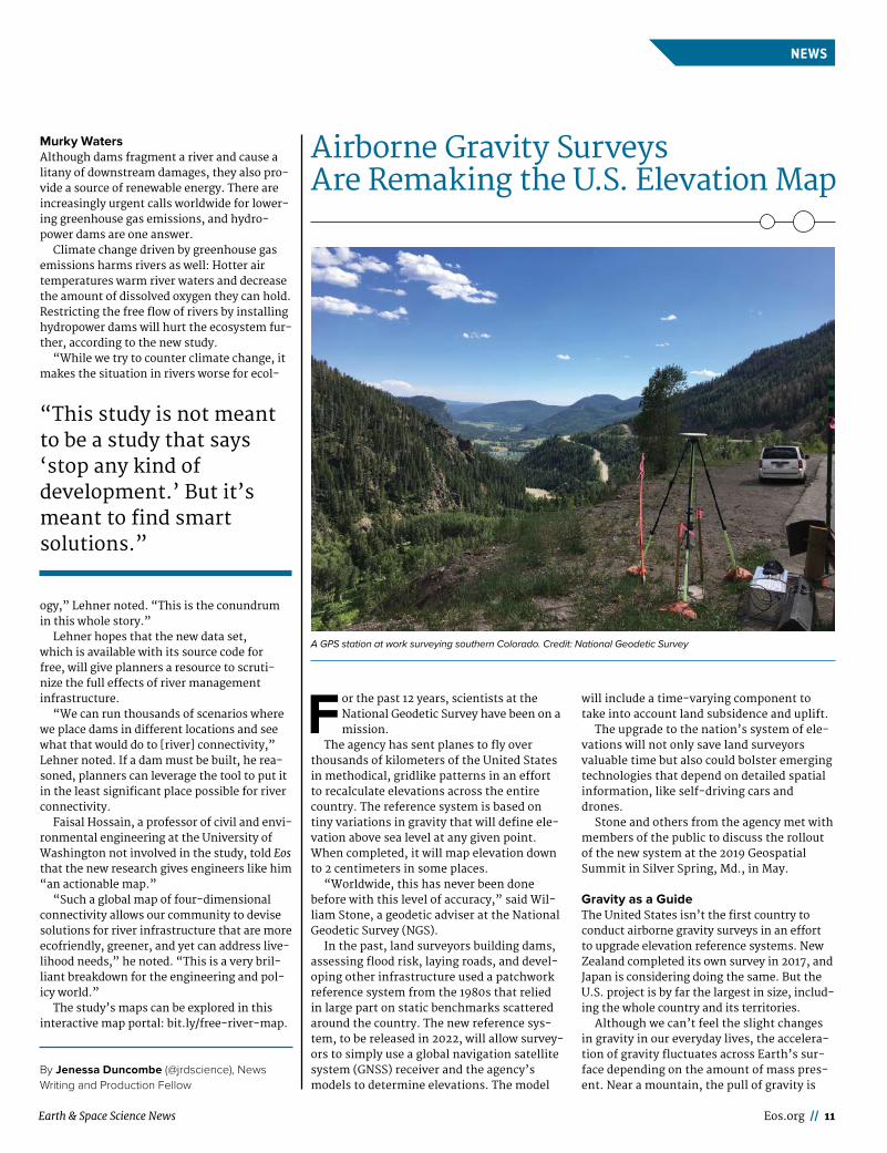
Airborne Gravity Surveys Are Remaking the U.S. Elevation Map
F or the past 12 years, scientists at the National Geodetic Survey have been on a mission.
The agency has sent planes to fly over thousands of kilometers of the United States in methodical, gridlike patterns in an effort to recalculate elevations across the entire country. The reference system is based on tiny variations in gravity that will define ele-vation above sea level at any given point. When completed, it will map elevation down to 2 centimeters in some places.
“Worldwide, this has never been done before with this level of accuracy,” said Wil-liam Stone, a geodetic adviser at the National Geodetic Survey (NGS).
In the past, land surveyors building dams, assessing flood risk, laying roads, and devel-oping other infrastructure used a patchwork reference system from the 1980s that relied in large part on static benchmarks scattered around the country. The new reference sys-tem, to be released in 2022, will allow survey-ors to simply use a global navigation satellite system (GNSS) receiver and the agency’s models to determine elevations. The model
will include a time- varying component to take into account land subsidence and uplift.
The upgrade to the nation’s system of ele-vations will not only save land surveyors valuable time but also could bolster emerging technologies that depend on detailed spatial information, like self- driving cars and drones.
Stone and others from the agency met with members of the public to discuss the rollout of the new system at the 2019 Geospatial Summit in Silver Spring, Md., in May.
Gravity as a GuideThe United States isn’t the first country to conduct airborne gravity surveys in an effort to upgrade elevation reference systems. New Zealand completed its own survey in 2017, and Japan is considering doing the same. But the U.S. project is by far the largest in size, includ-ing the whole country and its territories.
Although we can’t feel the slight changes in gravity in our everyday lives, the accelera-tion of gravity fluctuates across Earth’s sur-face depending on the amount of mass pres-ent. Near a mountain, the pull of gravity is
A GPS station at work surveying southern Colorado. Credit: National Geodetic Survey

12 // Eos July 2019
NEWSNEWS
stronger because of the mountain’s mass, whereas near a valley, the gravitational pull weakens. The change is slight: The pull of gravity might change by a fraction of a per-cent.
The airborne surveys detect the tiny oscil-lations in gravity using gravimeters, instru-ments housed in a series of gimbals and joints to protect them from the plane’s vibrations. The gravimeters contain a weighted rod attached to a spring, which flexes over areas with a stronger pull and relaxes over regions with lower gravity. The airborne survey passed its 75% completed mark in February, and the current operation stretches from South Carolina to Hawaii and American Samoa.
A Modern GeoidThe new elevation system will be based on gravity measured across three spatial scales: NASA’s Gravity Recovery and Climate Experi-ment (GRACE) and the European Space Agency’s Gravity Field and Steady- State Ocean Circulation Explorer (GOCE) satellites, which record gravity changes from space; the airborne survey; and ground- based stations. Together, the measurements combine to cre-ate a picture of the gravity contours, which can be used to trace the position of sea level inward.
“It’s only recently that we’ve been able to get a good enough measurement of the
gravity field to even consider doing this,” Vicki Childers, chief of the Observation and Analysis Divi-sion at NGS, said. “It’s been kind of the holy grail for a long time.”
The ultimate goal of the project is to create the equipo-tential geoid, a map of one particular gravity surface stretching from coast to coast. The geoid allows users to simply determine exact elevation from the coordinates of their GNSS devices. Having the geoid as a resource would cut the amount of time cartographers cur-rently spend survey-ing by 10, according to a 2007 NGS report.
The geoid model will include a novel feature that takes into account the slow movement of the ground sinking and rising over time. Earth’s surface is con-
stantly shifting, and the geoid model will factor in those changes. It also offers
the model flexibility to include instantaneous changes, like a volca-
nic eruption or an earthquake.“Right now, even though we live
on a dynamic Earth, our reference system has been stationary,” said NGS scientist Kevin Ahlgren. But with the new model, “when that big earthquake happens, we’re ready to remeasure things after-
ward and build that into the model.”
Elevations RedefinedThe new elevation data will save the
United States an estimated $4.8 billion over 15 years from advances in floodplain map-ping, emergency planning, storm surge cal-culations that affect coastal management, and other activities. The gravity survey, called Gravity for the Redefinition of the American Vertical Datum, is budgeted at just under $40 million.
Updated elevation data are only one part of the massive undertaking by the National Geodetic Survey to redefine the 3- D reference system in the United States, the National Spatial Reference System, that will go live in 2022. The new system includes not only recalculated elevations but updated latitude and longitude data as well (http://bit.ly/ spatial - ref).
Taken together, the new abundance of spa-tial data could augment automated transpor-tation in the future.
“We’re right on the precipice of self- driving vehicles,” Stone said. Self- driving cars and drones of the future will need extremely accurate 3- D information, accord-ing to Stone, as well as a shared reference frame among them. He believes the new NGS reference system could serve as their guide.
“It’s going to revolutionize a lot of appli-cations that aren’t possible today,” Stone said.
By Jenessa Duncombe (@jrdscience), News Writing and Production Fellow
A plane measures gravity over the Hawaiian island chain in February 2019 for the NGS
airborne gravity survey (top). A partially completed gravity survey map (bottom);
mGal = milligal. Credit: National Ocean Service/NOAA.
Geoid model showing areas of stronger gravity (red) and
weaker gravity (blue) measured by the GOCE satellite.
Satellite measurements are one of three main sources of
gravity information for the National Geodetic Survey’s
new elevations. Credit: ESA/HPF/DLR

Earth & Space Science News Eos.org // 13
NEWS
L egislation to establish a national system of wildlife corridors in the United States was introduced just days after a United
Nations (UN) report was issued in May warn-ing that about 1 million species worldwide are threatened with extinction.
The Wildlife Corridors Conservation Act of 2019 would establish a system to help native animal and plant species—including protected species—that face habitat loss, degradation, fragmentation, or obstructions to connectivity between their habitat areas. The bill aims “to provide long-term habitat connectivity for native species migration, dispersal, adaptation to climate and other environmental change, and genetic exchange.”
In addition, the bill would establish a grant program on nonfederal land and water to increase wildlands connectivity. It would also include a stewardship fund to help manage and protect the corridors.
Crucial to Human ExistenceThe legislation is “a critical step to protect wildlife,” Sen. Tom Udall (D-N.M.), who introduced the legislation in the Senate, said at a 16 May briefing about the bill.
“While we are in the middle of a human-caused sixth mass extinction, scientists are raising the alarm. We are almost out of time to save the planet as we know it,” Udall com-mented, referring to the UN report.
The report, which was compiled by 145 expert authors, states that the rate of global change in nature during the past half century “is unprecedented in human history.” It also found that the global rate of species extinction “is already at least tens to hundreds of times higher than the average rate over the past 10 million years and is accelerating.”
The report calls for urgent “transformative changes” to reverse the situation and states that direct drivers of change in nature that have the largest global impact are, in order, changes in land and sea use, exploitation of organisms, climate change, pollution, and the invasion of alien species. It warns that the future impacts of climate change on biodiver-sity and ecosystem functioning are projected to become more pronounced over the coming decades.
Speakers at the briefing said that biodiver-sity is important to protect not only because species have their own purposes in the ecolog-
ical web but also because they provide sub-stantial benefits to people.
“If anyone thinks that biodiversity is not crucial to human existence, think again,” Udall said, noting that at least 40% of the world’s economy is based on biological resources and that the diversity of life pro-vides humanity with food, shelter, medicine, and economic development, among other benefits. “Living ecosystems support us. America’s wildlife is in great jeopardy,” he said. “We must act now.”
No Second Chance After a Species Goes ExtinctEstablishing a wildlife corridors system “is something that shouldn’t be about party. It should be about just saving our planet,” said Rep. Don Beyer (D-Va.), who introduced com-panion legislation in the House.
Beyer, who is cochair of the New Democrat Coalition’s Climate Change Task Force, said that he and cosponsor Rep. Vern Buchanan (R-Fla.) will be working with the House lead-ership to get the bill on the House calendar. He also said that Rep. Raúl Grijalva (D-Ariz.), chair of the House Committee on Natural
A Wildlife Corridors System to Protect Species
Pronghorn antelope, which migrate more than 250 kilometers from winter to summer feeding grounds in the West, would be among many species to benefit from protected wildlife
corridors. Credit: iStock.com/Dean_Fikar

14 // Eos July 2019
NEWSNEWS
Tree Rings Record 19th- Century Anthropogenic Climate Change
A t some point in the past few hundred years, human activities became a dominant force influencing Earth’s
climate, affecting natural hazards such as drought. But it’s difficult to pinpoint exactly when this tipping point occurred. A new study tracking temperature seasonality—the differ-ence between summer and winter mean tem-peratures—has found that major indicators of global warming were present as early as 1870.
“It is well known that humans are driving global warming, but when did this begin?” asked Jianping Duan, a paleoclimatologist at the Chinese Academy of Sciences in Beijing and lead author of the study, published in April in Nature Sustainability (bit.ly/ tibetan - tree). “Our study has shown that anthropo-genic influence on climate change started much earlier than the 20th century.”
Determining when human activity began “driving global warming” is difficult because instrumental climate records go back only about 100 years. “We need a reference period long enough to judge when anthropogenic cli-mate change began,” Duan said.
To reconstruct paleoclimate data for the past 300 years, Duan and his colleagues turned to tree ring records collected on the Tibetan Plateau from trees that can live for more than 300 years.
By measuring the width and density of the trees’ rings, the researchers were able to track changes in seasonal temperature fluctuations. They found that temperature seasonality was relatively stable until the 1860s and began decreasing in the 1870s. At that point, winters began getting warmer, closing the tempera-ture gap between the two seasons. Research-ers also found evidence supporting the same conclusion in proxy- based seasonal tempera-ture reconstructions in Europe.
The team also used climate model simula-tions to show that greenhouse gases and aero-sols have been the primary drivers of climate change since the late 19th century. “Our study shows that the detectable weakening of tem-perature seasonality, which started synchro-nously over the northern mid– high latitudes since the late 19th century, can be attributed to anthropogenic forcing,” Duan said.
Models also showed that increased green-house gas concentrations are the main con-tributors over northern high latitudes, whereas sulfate aerosols are the major con-tributors over northern midlatitudes.
Most paleoclimate studies focus on increas-ing surface air temperatures, but seasonal temperature fluctuations provide a comple-mentary data set, said Michael Evans, a paleo-climatologist at the University of Maryland in College Park who was not involved in the new study.
“The annual cycle is the largest- amplitude form of variation that we see in our modern climate. It’s important to know how that might change and why, as it influences how organisms function within their ecosystems,” Evans said. For example, trees may start bud-ding earlier, or migratory birds may fly south later, taking advantage of milder winters.
Previous studies have shown that the annual temperature cycle—calculated as the difference between summer and winter tem-perature extremes—has been decreasing over the past several decades. The new study is among the first to use paleoclimate records to trace this trend so far back in time.
“The next step will be to see how the decrease in seasonal temperature fluctuations affects our living environment and its impact on agriculture, ecology, and perhaps human health,” Duan said.
By Mary Caperton Morton (@ theblondecoyote), Science Writer
Resources, has indicated that he wants to push this legislation in that committee.
Beyer optimistically stated that he expects “scores of Republican votes when it gets to the House floor.” No Republicans had signed on to earlier versions of the bill introduced during previous sessions of Congress, and Buchanan is so far the sole Republican cosponsoring the new legislation.
Raising Concern About BiodiversityAt the briefing, Ron Sutherland, chief scientist with the Wildlands Network, a Seattle, Wash.-based conservation group that sup-ports the legislation, speculated about why concern about biodiversity hasn’t yet caught on as a hotter issue in the same way that cli-mate change has.
“One perspective might be that there was a huge push to protect biodiversity for its own sake in the ’90s, and I think that that push eventually earned the sort of inevitable fatigue
on all the champions for it. Climate change became kind of the new cause, and a lot of young folks have joined into that movement,” Sutherland said. “I think we’re remembering the fact that we depend on the Earth’s biodi-versity. Now, pollinators have become such a huge cause lately. So I think that the pendu-lum is shifting or at least is broadening again, so that there’s room again to talk about the other environmental challenges that we’re facing. It’s not just climate change. It’s land use change that is causing a huge threat to biodiversity.”
Sutherland noted, “That’s where this bill really could help out here in the United States: by helping repair the landscape to help species to survive and also to respond to climate change.”
A Political Problem, Not a Scientific Problem“Human intervention caused this mass extinction crisis. Now human intervention through legislation must reverse the tide,” Udall added. “We already know how to address this crisis. This isn’t a scientific problem. It’s a political one. The science is clear: Corridors help protect our most iconic species.”
By Randy Showstack (@RandyShowstack), Staff Writer
“We don’t get a second chance once a species becomes extinct.”
Ancient trees preserve paleoclimate records in the sea-
sonal growth of their rings, which can help scientists
reconstruct climate change over the past 300 years.
Credit: Mary Caperton Morton

Earth & Space Science News Eos.org // 15
OPINION
In July 1991, the freighter Tuo Hai collided with the fishing vessel Tenyo Maru off the northern coast of Washington State, result-
ing in an oil spill that quickly spread to cover hundreds of square kilometers. At the time, I was studying a seabird colony in the path of the spill, and I realized, as the oiled birds began to wash in, that we had no baseline against which to compare the mounting body count. How many wash in normally?
In years of coastal fieldwork, I had already noticed a seasonal uptick in the beaching of my focal species, the common murre, during the summer- fall transition. These deaths were a natural result of the end of the breeding sea-son, when exhausted parents and inept chicks are more likely to die as the winter storm sea-son begins, but I wondered to what degree this normal signal might be influenced by envi-ronmental forcing. To address either question,
I needed a much larger, longer- term data set on the beaching rate.
I decided to create that data set and in the process founded the Coastal Observation and Seabird Survey Team (COASST). At the time, I was a young faculty member looking for a method of expanding data collection beyond
the physical abilities of myself and my team. That mission has evolved over the course of 2 decades into a passion for promoting citizen science as a rigorous method of data collec-tion, fully worthy of being part of the toolbox of mainstream science.
Starting PointsWhere seabirds are found across the seascape is directly influenced by the quantity, quality, and predictability of their prey—a table that is set by oceanographic and atmospheric processes operating locally to globally, over days to decades. Seasonal upwelling, decadal climate patterns like the Pacific Decadal Oscil-lation, and relatively sudden shifts such as an El Niño or a marine heat wave will all influ-ence prey availability, causing birds to choose to move—rightly or wrongly—in search of dinner. Wrong choices result in death, and that drifting carcass will succumb to the wind, currents, and tides. In the Pacific Northwest, the body of a bird that dies within 125 kilo-meters of shore has a chance of reaching the beach before sinking. Those few car -casses washing ashore have a short shelf life before they are scavenged, buried by the
Science in This Century Needs People
Science is a team sport at COASST, where teams spread out to search the beach for bird carcasses and rejoin to process each one found. “Handlers” don latex gloves for protec-
tion, whereas “pencils” take charge of data recording and checking the field guide. After measuring and photographing, handlers tag a wing with a unique sequence of colored
bands that allows COASST to track persistence and leave the carcass in place. Credit: COASST
At its scientific best, citizen science can create huge, detailed data sets that capture these patterns at local, regional, and even global scales.

16 // Eos July 2019
OPINION
wind, or washed back out during the next high tide.
Despite these sources of variability, there is a discernible cadence to beaching over time, an annual rhythm that can be tracked by monthly surveys. The most important thing that COASST does is statistically document this regionally specific pattern—the right place, right time, right species baseline—of what birds are expected where and when.
I started COASST with the help of a postdoc who knew far more about ornithology than I did, a grant from the David and Lucile Packard Foundation, and a question: Could we find locals enthusiastic about collecting data on the identity, abundance, and condition of beached birds on an ongoing basis and in a standard-ized manner? We also needed to design a data collection program that allowed for expert verification of species identity. If these data were ever to be used in mainstream science or in a legal proceeding following an oil spill, they needed to be beyond doubt.
What we came up with is one of the sim-plest tenets of science: evidence first, deduc-tion second. In our case, the evidence includes classification of the foot type, three specific body measurements, and two photographs with a standard scale. The deduction is lowest taxonomic classification, which can be made with our custom field key, Beached Birds.
We started our data collection corps with 12 residents of Ocean Shores, along the south-ern coast of Washington. COASST today includes around 800 people collecting monthly data on beached birds and another 200 collecting data on marine debris. Our footprint stretches from Mendocino, Calif., to the Canadian border and throughout Alaska. We now work with partners in California (BeachCOMBERS and Beach Watch) and west-ern Canada (British Columbia Beached Bird Survey). That means our data collection cur-rently spans three large marine ecosystems: the California Current, Gulf of Alaska, and eastern Bering Sea, as well as parts of the western Bering Sea and Chukchi Sea.
Unlike citizen science programs that use online training and occasionally rely on self- taught hobbyists, COASST commits to hands- on, in- community trainings designed for beginners. If you can tell it’s a bird and it’s dead, we can teach you how to “get to species” in a single 5- hour session. And the citizens in our citizen science? They are citizens of the planet, citizens of the ecosystem. We start in new communities when we’re invited, and we work with local partners to recruit trainees without questioning their knowledge about birds or their politics. I’ve trained people in bars, churches, ferries, elementary schools, libraries, malls, tribal headquarters, and
senior centers. We currently visit about 80 small coastal communities in a 2- year cycle. And we commit to returning. We con-stantly communicate with our participants, offering feedback about whether that last car-cass they found really was a northern fulmar or sending out the latest information we have about how and why beaching patterns are changing.
So, yes, we travel a lot, and, no, citizen sci-ence isn’t free, nor is it easy. We write grant proposals to support our science just like everybody else, and we push ourselves and our collaborators to get that next paper submitted. We think about what we do and how we can make it better every day.
From Data to PeopleIn the beginning, I was obsessed with data quality and making sure our data collectors were being as accurate as possible. One way we solved that problem was by breaking down the science into component tasks, things like foot
type classification and body measurements. Although this approach worked with species identification, our efforts to control the sam-pling design weren’t as successful.
Initially, we created a specific list of sites to be surveyed on the basis of the substrate, ori-entation, and inclination of the beach. But people wanted to choose “their place” whether our sampling design indicated it was needed or not. It seems impossibly arrogant to me now, thinking back on it, that my starting expectation was that I could waltz into a coastal community and tell people what to do and that they would do it without question. That works with undergraduate students and tech-nicians, so why not with everyone else? We now know that what brings people to a train-ing in the first place—a strong attachment to a specific beach and a desire to learn more about that place—was also the reason they politely but firmly refused to be assigned a survey location. COASSTers now choose the beach they want, and over 90% of training attendees sign on to participate.
What I’ve come to realize is that COASSTers are first and foremost people. If COASST can pique their interests, support their sense of place, provide them with proper training, respond to their questions and concerns, and thus offer them an authentic role on our sci-ence team, we are rewarded with a cadre of highly devoted, rigorous, long- term data col-lectors. The average COASSTer is able to iden-tify the species of a carcass 87% of the time and maintains near- monthly survey fre-quency for about 3 years.
COASSTers understand their role as both scientific and social: They perform rigorous data collection, communicate to others about
Could we find locals enthusiastic about collecting data on the identity, abundance, and condition of beached birds on an ongoing basis and in a standardized manner?
In the fall of 2016, COASST partners on Saint Paul Island in the Pribilof Islands of Alaska recorded an unprecedented
mortality event of the tufted puffin population (shown here are two adult puffins and an adolescent at right). Deteriorat-
ing weather conditions forced surveyors from the Aleut Community of St. Paul Island Ecosystem Conservation Office
( ACSPI- ECO) to drive the beach in all- terrain vehicles, collecting carcasses and moving them off the beach to a safe
location for sorting and photographing. The resultant protocol, known as Die- off Alert, is now taught by ACSPI- ECO
and COASST in communities throughout coastal Alaska. Credit: ACSPI- ECO

Earth & Space Science News Eos.org // 17
OPINION
Be a resource for first-time Fall Meeting
abstract submittersagu.org/mentor
COASST, and recruit community members into the program. They talk to friends and family about their experiences, and they connect with influencers such as resource managers, politi-cians, and the media to tell them about our research findings. COASSTers embody the saying “Bear witness, take action.”
Big Data Citizen ScienceDocumenting environmental change requires long- term data on where and when natural things happen: earthquakes, extreme weather, the first flowers of spring, dead birds on beaches. At its scientific best, citizen science can create huge, detailed data sets that cap-ture these patterns at local, regional, and even global scales. In COASST, thousands of partici-pants have created a highly accurate, highly rigorous data set that has gone directly into science and resource management.
Our science stories are sobering. We’ve doc-umented the largest marine bird die- off on record anywhere in the world due to a harmful algal bloom. We’ve shown that the impact of the largest and longest- lasting marine heat wave the planet has yet experienced included multiple, massive seabird mortality events
from California to Alaska. Working with resource management partners, we’ve co -created a series of annual ecosystem indica-tors that inform everything from the Califor-nia Current Integrated Ecosystem Assessment to the annual report to the North Pacific Fish-ery Management Council. COASST is regularly asked to assist in decision- making on the basis of our data and our expertise: Should the hunting season for marine ducks be opened next week? Do these carcasses present a dis-ease risk to coastal peoples? Should the beaches be closed to tourists? We do science that matters.
If the past century was about expansion of science through technology, this century had better be about expansion through people. Closing the doors of the ivory tower and cloak-ing ourselves in a language that few can understand won’t save science, and it certainly won’t save the world.
Expanding our science teams to include everyone with an interest or a need is a scary but exciting thought because as the face of science changes, so will the practice. With a larger and more diverse team, we will askand answer questions differently. Citizen sci-
ence is one strand of that braided river of change. And now that I’m in it, I honestly can’t imagine why I would ever do things any other way.
By Julia K. Parrish ( jparrish@ uw . edu), University of Washington, Seattle
A dark gray northern fulmar is one of the top three spe-
cies recorded by COASST. In addition to noting its shape,
COASST participants record the bill measurement—a
straight line from tip to “hairline”—on each carcass
found. Credit: COASST

18 // Eos July 2019
OPINION
L ast December, several early- career bio-geoscientists got some timely assistance at AGU’s Fall Meeting 2018. Early- career
scientists are often starting families as well as careers, and caregiver responsibilities some-times present a barrier that can prevent them from fully participating in conferences and obtaining the career benefits of sharing their research and networking with other scientists. These opportunities are critical for early- career researchers who are working to estab-lish their scientific reputation and find jobs in research fields.
AGU’s Fall Meeting 2018 served as the offi-cial launch of the organization’s Centennial celebrations centering around ideas that transform Earth and space science and how we conduct our research. In 2018, the Biogeosci-ences Early Career Committee saw this as motivation to establish the Early Career Care-giver Award. This award was given to Biogeo-sciences section early- career members attending Fall Meeting who had extra financial constraints associated with being a primary caregiver for a child or other dependent.
An Opportunity to Meet a NeedIn 2018, each AGU section received $5,000 to spend toward early- career programming at Fall Meeting 2018. The Biogeosciences Early Career Committee decided to use a portion of the money to fund awards to early- career members to offset conference attendance costs associated with being a primary care-
giver. Such responsibilities can include day-care, hiring a temporary caregiver, covering conference registration costs for a child, or supporting a nonscientific partner’s atten-dance as a caregiver. One recent study showed that 43% of women and 23% of men among new STEM parents left the workforce, switched fields, or transitioned to part- time jobs, suggesting that early- career mothers (and, to a lesser extent, fathers) face chal-lenges as caregivers with STEM careers [Bern-stein, 2019; Cech and Blair- Loy, 2019].
Attending a conference with a child or other dependent brings substantial financial costs, including travel and hotel rooms for the dependent. In addition, without supplemental childcare, a conference attendee may not have the time to participate fully in the conference. Conference organizers face challenges as well as they attempt to support early- career par-ents and families [Calisi and a Working Group of Mothers in Science, 2018]. In particular, early- career mothers face a “baby penalty” that
prevents them from enjoying a thriving con-ference experience. This penalty can be reduced if resources like lactation rooms, affordable on- site childcare, and childcare support are provided.
How do science conferences stack up now? The Science Careers team from the American Association for the Advancement of Science (AAAS) evaluated 34 conferences in North America in 2018. It determined that 94% pro-vided lactation rooms and 68% provided child-care support, but the percentages are much lower for conferences in physical sciences, mathematics, and computer sciences [Langin,2018]. Although the overall statistics are encouraging, these services are not enough for early- career parents for whom conference attendance requires extensive logistical plan-ning and can be prohibitively expensive [Grens,2017].
Beginnings of a SolutionThe Biogeosciences Early Career Committee members (Benjamin Sulman, Aditi Sengupta, Zachary Brown, Melany Ruiz, and Ceth Parker), with help from 2018 section president Ariel Anbar and president- elect Elise Pendall, crafted an award announcement call and solicited applications from Biogeosciences section early- career members who are pri-mary caregivers and were planning to present at Fall Meeting 2018. The announcement was advertised through social media and the Bio-geosciences section newsletter.
The committee received 17 applications from early- career scientists ranging from Ph.D. students to assistant professors. The majority of applicants were early- career mothers. The evaluation criteria focused on the applicant’s need for support and how the award would improve the applicant’s ability to fully participate in the meeting, and the potential of the award to enhance the appli-cant’s career through meeting attendance.
The committee disbursed eight awards of $500 each. Fathers made up 35% of the appli-cant pool, demonstrating the strides that fathers are making to share caregiver respon-sibilities. Nevertheless, the applicant pool demonstrated that women still bear the bulk of responsibility for child and dependent care, consistent with a wide body of research [ Jolly et al., 2014; McBride and Mills, 1993; Pew Research Center, 2013; Yavorsky et al., 2015].
Although all of the applicants in 2018 were caregivers of children, the solicitation recog-nized that early- career members may be care-givers of a disabled or elderly family member. Thus, the awards were open to early- career attendees who were caregivers for any type of dependent rather than being restricted to par-ents of young children.
Caregiver Awards Support Early- Career Researchers
Without supplemental childcare, a conference attendee may not have the time to participate fully in the conference.
Last December, scientists—and their families—gathered in Washington, D.C., for AGU’s Fall Meeting 2018. Credit: Event
Photography of North America Corporation

Earth & Space Science News Eos.org // 19
OPINION
Evidence of SuccessMany applicants were enthusiastic in pointing out the need for such awards. For example, Kim Novick, an award winner, said, “the sup-port made it easier to ensure my infant had high- quality care while I attended AGU. It also gave me a sense that the AGU Biogeosciences section valued my dual roles as a scientist and a parent to young children.”
As one of the awardees, Mary Whelan, points out, there is a lack of institutional and cultural support to childbirth and subsequent care of young children, “with the awards serv-ing as a way to retain a productive STEM work-force by supporting their personal life choices while enhancing their professional develop-ment.”
Caregiver awards and resources are critical to encouraging women and men to stay in sci-entific fields through their children’s early years and provide shared experiences as a family, as noted by another awardee, Audrey Taylor.
Following the announcement of the awards, the Biogeosciences section and the Early Career Committee received phenomenal sup-port and kind words from many early- career and late- career members. They reaffirmed that the awards supported inclusion and the success of early- career researchers whose responsibilities as caregivers currently pose challenges to their professional growth.
Building on Our SuccessIn addition to travel grants, we suggest broader efforts to support caregivers at the Fall Meeting. These efforts could include sup-porting facilities like lactation rooms, provid-
ing lockers or other spaces to parents to store caregiver- associated supplies, subsidizing on- site childcare costs for early- career attendees, reducing registration fees for sup-porting family members, and seeking addi-tional sponsorship- based funding. Further-more, we believe that it is essential for this program to develop a stronger and more sta-ble base of financial support, rather than requiring individual sections to allocate ad hoc early- career funding. Support at the AGU level would allow the program to maintain long- term continuity as well as open it to conference attendees from multiple sections.
In addition to offering direct assistance to early- career conference attendees, another goal of the awards was to encourage other sec-tions and AGU as a whole to support early- career members. We propose a society- wide change in which all sections unite to promote diverse representation by supporting early- career members as they balance their profes-sional and caregiver responsibilities.
As a scientific community, if we truly are to stand for inclusive excellence and transfor-mative science, it is imperative that we strive to support our members and welcome their identities. As AGU celebrates its Centennial and looks forward to an exciting time in advancing Earth and space science research, supporting early- career members in their dual roles as caregivers and researchers will send a message of an inclusive and welcom-ing scientific society.
AcknowledgmentsThe authors acknowledge the AGU Biogeosci-ences section leadership, the award winners,
and the early- career members who competed for the awards. This article complies with AGU’s data policy: The data are available from the authors on request. All opinions expressed here represent personal views of the authors and awardees and are not associated with the individuals’ institutions.
ReferencesBernstein, R. (2019), After a baby, 28% of new parents leave full-
time STEM work, Science, https:// doi . org/ 10 . 1126/ science . caredit . aax0346.
Calisi, R. M., and a Working Group of Mothers in Science (2018), Opinion: How to tackle the childcare- conference conundrum, Proc. Natl. Acad. Sci. U. S. A., 115(12), 2, 845– 2,849, https:// doi . org/ 10 . 1073/ pnas . 1803153115.
Cech, E. A., and M. Blair- Loy (2019), The changing career trajecto-ries of new parents in STEM, Proc. Natl. Acad. Sci. U. S. A., 116(10), 4, 182– 4,187, https:// doi . org/ 10 . 1073/ pnas . 1810862116.
Grens, K. (2017), Baby on board, Scientist, 1 Sept., https:// www. the - scientist . com/ careers/ baby - on - board - 30991.
Jolly, S., et al. (2014), Gender differences in time spent on parenting and domestic responsibilities by high- achieving young physician- researchers, Ann. Intern. Med., 160(5), 344– 353, https:// doi . org/ 10 . 7326/ M13 - 0974.
Langin, K. (2018), Are conferences providing enough child care support? We decided to find out, Science, https:// doi . org/ 10 . 1126/ science . caredit . aaw3741.
McBride, B. A., and G. Mills (1993), A comparison of mother and father involvement with their preschool age children, Early Child. Res. Q., 8(4), 457– 477, https:// doi . org/ 10 . 1016/ S0885 - 2006 (05) 80080- 8.
Pew Research Center (2013), Modern parenthood: Roles of moms and dads converge as they balance work and family, Washington, D.C., www . pewsocialtrends . org/ 2013/ 03/ 14/ modern - parenthood - roles - of - moms - and - dads - converge - as - they - balance - work - and - family/.
Yavorsky, J. E., C. M. K. Dush, and S. J. Schoppe- Sullivan (2015), The production of inequality: The gender division of labor across the transition to parenthood, J. Marriage Family, 77(3), 662– 679, https:// doi . org/ 10 . 1111/ jomf . 12189.
By Aditi Sengupta ( aditi . sengupta@ pnnl . gov), Earth and Biological Science Directorate, Pacific Northwest National Laboratory, Richland, Wash.; Benjamin Sulman, Energy and Environmen-tal Sciences Directorate, Oak Ridge National Laboratory, Oak Ridge, Tenn.; Zachary Brown, University of Tasmania, Hobart, Australia; Melany Ruiz- Urigüen, Department of Civil and Environmental Engineering, Princeton University, Princeton, N.J.
Children of attendees at AGU’s Fall Meeting 2015 enjoy activities at Exploration Station. Credit: Karna Kurata/
www . garywagnerphotos.com
Audrey Taylor, one of the award recipients, with her
daughter on her way to AGU’s Fall Meeting 2018. Credit:
Photo provided with permission from Audrey Taylor

Samples of the Moon’s surface broughtback by Apollo astronauts ushered in a new
era of planetary science. Scientists today continue the legacy.
50 Years of Lunar Geology
APOLLO’S LEGACY
By Kimberly M. S. Cartier
20 // Eos July 2019
Apollo 15 astronaut James Irwin collects samples near the eastern rim of
Imbrium Basin, not far from the lunar roving vehicle (opposite), with the
lunar module in the background. Credit: NASA/Lunar and Planetary Institute

Earth & Space Science News Eos.org // 21
July 20, 1969, will forever be carved into the history books: the day that humankind took its first small step into the cosmos. The dawn of a new scientific era came just 4 days later.
When Apollo 11 splashed down on 24 July, planetary scientists knew they would soon get their hands on the first samples of material brought back from the surface of the Moon.
Apollo 11 astronauts brought back a scant 22 kilograms of material for sci-entists to study. Each subsequent Apollo mission—except Apollo 13, of course—brought back more and more rocks, soil samples, and drill cores. All told, the Apollo astronauts carried back to Earth 382 kilograms from six differ-ent areas of the Moon’s surface, each sample stored in a container that pre-served a Moon- like environment.
The initial impressions of the Apollo samples proved for the first time some facts about the Moon that may seem obvious today: There is not now and there likely never has been life on the Moon; meteor impacts throughout the Moon’s history have pulverized the
surface; and the Moon and Earth share many geochemical similarities.
But technology, computer power, and scientific knowledge have grown exponentially since humans last stepped foot on the Moon in 1972. Thanks to the foresight of NASA lead-ers of the time, some of the Apollo samples were curated so that future scientists could study pieces of the Moon that hadn’t been exposed to Earth’s atmosphere.
“What we like to say is that sample return missions allow scientists not yet born to use instruments not yet developed to answer questions not yet asked,” Jamie Elsila, an astrochemist at NASA Goddard Space Flight Center in Greenbelt, Md., told Eos.
Today “we’re asking some of the same questions that the scientists back then were asking,” Elsila said. “Because [NASA] preserved these samples and curated them carefully, now we’re able to go back and try to answer these questions.”
As post- Apollo scientists studied carefully doled- out lunar samples, they discovered much more about the

22 // Eos July 2019
Moon and its history than scientists of the 1970s could have. Here are some of the most notable discoveries about our celestial neighbor that have come from Apollo samples over the past 50 years.
The Rough Life of Lunar RegolithLife as a soil grain on the lunar surface is tough. Nowadays it’s rare for a large impact to happen on the Moon, but microscopic impacts happen all the time.
“The lunar regolith is being bombarded by micromete-orites and high- energy particles from the solar wind,” explained Richard Walroth, an instrument developer at NASA Ames Research Center in Mountain View, Calif.
Earth’s atmosphere protects its surface from these microscopic hits. On the airless Moon, however, tiny mete-orites, cosmic rays, and superfast ions from the Sun con-stantly strike the surface. This process, called space weathering, makes the lunar regolith literally rough around the edges.
“The grains melt at the very edge and form things called agglutinates,” Walroth said, which are mineral fragments fused together by glass. “They also get a little nanophase iron too. They’re like nanoscale droplets, essentially of metallic iron in glass.”
Walroth and his team have developed instruments to look at the mineralogy and weathering of agglutinates and other Apollo samples.
The samples returned by Apollo astronauts bear the scars of space weathering, but some of the regolith sam-ples were shielded from one type of weathering for mil-lions of years.
“Shadowed soils...were collected at the surface but underneath the overhangs of boulders,” said Barbara
Cohen, a planetary scientist at NASA Goddard Space Flight Center. “In that case, we think that they were shadowed from things like micrometeorite impacts, but they were still exposed sometimes over seasonal and day- and- night cycles to things like solar wind.”
“They might have a different total exposure history” than soils that were exposed to all types of space weather-ing processes, Cohen said. Comparing soils collected in different places will help Cohen and her team tease out which processes cause the different weathering signatures they see in Apollo samples.
“Space weathering is a global process,” Walroth said, but “every part of the Moon’s going to get affected by it a little bit differently.”
Something Old, Something Slightly Less OldIt turns out that lunar rocks become discolored as they age, and close- up study of the Apollo samples helped explain why.
“Space weathering is a really complex set of processes that affect these grains very much at the nanoscale,” Katherine Burgess, a geologist at the U.S. Naval Research Laboratory in Washington, D.C., told Eos. Burgess uses transmission electron microscopy to study how weathering chemically alters the surfaces of planetary bodies.
Space weathering processes “have huge impacts in how planetary bodies look spectroscopically from spacecraft and telescopes and change their optical properties,” she explained. “That’s generally referred to as reddening or darkening.”
By studying the Apollo samples over the past 50 years, “we’ve figured out that the main cause of these optical changes is the formation of [nanophase iron] rims that
Left: Apollo 12 astronauts collected 34 kilograms of soil and rocks from the Moon’s surface that they brought back to Earth for scientists to study. Seen
here, Alan Bean holds up a filled sample tube during an extravehicular activity on 20 November 1969. Charles “Pete” Conrad is reflected in his visor.
Top right: Lunar sample 74220 contains orange soil discovered near Taurus- Littrow Valley during the Apollo 17 mission. A 2.1-millimeter-wide thin section
of some of the glass is seen here in transmitted light. Bottom right: Apollo 15 astronauts brought back regolith samples that included clods of green soil.
Within the soil were small spheres of green volcanic glass, like these that were found in sample 15426. Credits, clockwise from left: NASA/Marshall
Space Flight Center; D. Kring/NASA/Lunar and Planetary Institute; NASA/Johnson Space Center, Lunar and Planetary Institute

Earth & Space Science News Eos.org // 23
are up to a couple of hundred nanometers thick,” Burgess said.
How much a grain has been altered by weathering pro-cesses can tell researchers how long it was left exposed on the surface. This is key to understanding the Moon’s geo-logic history and how long it takes for surface rocks to be buried underground.
“You know, we say that Neil Armstrong’s boot prints will be there forever,” Walroth said, “but in reality, they are eventually going to be buried by all the regolith. It’ll just take a long time.”
What’s become clear to lunar geologists is that apart from large and small meteorite impacts that churn up the regolith, the Moon’s surface is still aging, just very slowly. “These are processes that take place over millions of years,” he said.
Change on the (Solar) WindSpace weathering does more than just rough up the lunar regolith, said planetary geologist Natalie Curran. It can also change the regolith’s composition.
“Cosmic rays from outside of the solar system produce noble gases in these samples,” said Curran, who works at NASA Goddard Space Flight Center. “The cosmic rays basi-cally interact with elements in the rock—so things like oxygen, silicon, or magnesium—and they form actual noble gases.”
“There were very relatively low abundances of noble gases in the rock to start with,” she said, because the Moon’s original stock of volatile gases is long lost to space. “So the more exposed to the space environment and the more cosmic rays hit that sample, the more isotopes of noble gases are produced.”
The Sun, too, has its own noble gases to impart to the Moon’s surface through the solar wind.
Solar wind noble gases “get implanted into the surface of these very, very small grains, and they have a different isotope ratio to what the cosmic ray– produced noble gases have,” Curran said. “So we can measure all these noble gases in a sample and then look at the different iso-topes to see which noble gas is produced from each of the different reservoirs.”
Noble gas analysis is another way that scientists can learn more about the signatures of different space weath-
ering processes. Curran and Cohen are working to do just that.
“We’re interested in seeing the differences between things that are completely exposed all the time and these things that were partially eclipsed by boulders at some point in their history,” Cohen said. “If some effects shut off and others keep going, then we would be able to say, ‘Oh, that’s what the signature of this other effect looks like.’”
Glass, Glass EverywhereThe lunar surface might seem to be all shades of gray, but that’s definitely not the case everywhere on the Moon. Apollo 17 astronauts Harrison Schmitt and Eugene Cer-nan and CapCom Robert Parker learned this firsthand. Here’s a short excerpt from a recording of the moment of discovery:
Schmitt: It’s all over! Orange! Cernan: Don’t move it until I see it. Schmitt: I stirred it up with my feet. Cernan: Hey, it is! I can see it from here! Schmitt: It’s orange! Cernan: Wait a minute, let me put my visor up. It’s still orange! Schmitt: Sure it is! Crazy! Cernan: Orange! Schmitt: I’ve got to dig a trench, Houston. Parker: Copy that. I guess we’d better work fast. Cernan: Hey, he’s not going out of his wits. It really is. Parker: Is it the same color as cheese?
The orange soil is actually a deposit of microscopic orange glass mixed with the beige- gray regolith. These glass beads formed when ancient lunar “fire fountains” belched up molten magma, some of which condensed into droplets of pyroclastic glass and rained down onto the lunar surface 3.5 billion years ago.
“What most people don’t realize is that the soil on the Moon is about 20% glass beads” in the areas we’ve sam-pled, Darby Dyar, a planetary scientist at Mount Holyoke
College in South Hadley, Mass., told Eos. Dyar, also at the Plane-tary Science Institute in Tucson, Ariz., has been studying lunar glass beads since she was in graduate school.
Apollo 15 samples contained similar glass beads that were tinted green. “What you see is, there’s about 5% to 20% of these little rounded glass beads which come from the volcanic glass fire fountains,” she said.
“The lunar soil is really fasci-nating in and of itself. The little glass beads are just one compo-nent of a really fascinating mate-rial,” Dyar said.
Returned samples are
an investment in the future.
These typical lunar soil agglutinates are from Apollo 11 lunar sample 10084. (a) NASA photo S69- 54827, an optical
microscope photograph of a number of agglutinates with a variety of irregular shapes. (b) NASA photo S87- 38812, a
scanning electron photomicrograph of a ring- shaped agglutinate with a glassy surface coated with small soil frag-
ments. Credit: The Lunar Sourcebook, via Lunar and Planetary Institute

24 // Eos July 2019
Donate to the Austin Student Travel Grant Challenge.
Austin-challenge.agu.org
Help Send 60 MoreStudents to Fall Meeting!
No Water Above, but Traces Below“At the time the Apollo samples came back,” Dyar said, “the techniques that we had to analyze them at that time indicated…that there was absolutely no water on the Moon. Certainly, no hydrous minerals, you know, no micas, no clay minerals, no amphibole.” On Earth, these minerals form in the presence of water.
Other tests for lunar water looked at the ratios of differ-ent iron molecules. “That tells us something about how much oxygen was around when these materials formed,” she explained.
In a water- poor environment, iron will usually lose two electrons and exist in ferrous minerals, which are consid-ered reduced. If there is any water around, that water can steal a third electron and create ferric compounds, which are oxidized.
“By 1980, the dogma was that the Moon was both com-pletely dry and completely reduced,” Dyar said.
More advanced techniques and more sensitive instruments changed that dogma. Close looks into the volcanic glass beads found that they contain signatures of water, something that has been recently confirmed. And recent research has found that ionized hydrogen from the solar wind creates trace amounts of water in the lunar regolith.
“In the last decade, we’re suddenly revolu-tionizing our idea about what the interior of the Moon looks like,” Dyar said. “It looks like it might actually have had, at the time these were erupted, significant amounts of both water and oxygen around. That’s quite paradigm shifting.”
Amino Acids from Afar“When the Apollo astronauts first brought these samples back,” Elsila said, “there was a lot of interest in understanding amino acids and potential organic compounds relevant to life in these samples.”
Although it is still unclear how life began on Earth, sci-entists thought it possible that the collision that formed the Moon out of Earth’s crust and mantle also could have transferred the building blocks of life to the Moon.
“In the 1970s, there were a lot of studies looking for amino acids in lunar samples, and they were detected, but the origins weren’t able to be determined at that point,” Elsila said. There were fierce debates about whether the amino acids were really from the Moon or from accidental contamination.
A few years ago, Elsila led a team that reexamined amino acids in Apollo 16 and Apollo 17 samples to pinpoint their origins.
“We found that they were probably a combination of terrestrial contamination just from the sampling process and the curation process,” Elsila said, “but also some
amino acids that seem to be indigenous to the lunar sur-face.” Lunar amino acids have a molecular structure dis-tinctly different from terrestrial ones, her team found.
How did those amino acids get there? “The ones we found are similar to amino acids that we’ve detected in meteorites and other extraterrestrial materials that have probably undergone abiotic chemistry,” Elsila said.
Meteorites might have implanted those amino acids on the Moon long ago. Alternately, Elsila said, the molecules’ precursors might have blown in on the solar wind and undergone abiotic chemistry to form amino acids. Com-paring lunar amino acids from areas exposed to impacts but not the solar wind and vice versa could help solve that mystery.
Investing in the FutureIn the next few months, NASA will give scientists access to some never- before- studied Apollo samples. Those sam-
ples have never tasted Earth’s atmosphere. They’ve been kept in the same condition
they were in when Apollo astronauts brought them back almost 50 years
ago.“Returned samples are an
investment in the future,” said Lori Glaze, acting direc-
tor of NASA’s Planetary Science Division in Wash-ington, D.C. “These sam-ples were deliberately saved so we can take advantage of today’s more advanced and
sophisticated technology to answer questions we
didn’t know we needed to ask.”The research teams NASA
selected to look at the samples will work with one another to cre-
ate a holistic view of the Moon’s geo-logic history as told by the Apollo pro-
gram. Many of the necessary tests will change those samples forever. But lunar geologists are already looking toward future exploration and future sample return missions to answer our lingering questions about the Moon.
“Unless you’re willing to put a rock on the lunar surface and wait a billion years,” Walroth said, “it’s going to be really hard to answer those questions. But that’s why we hope to get material from more and more places around the Moon.”
“Our Apollo samples all came from the nearside equato-rial region,” Cohen said. “We didn’t have the context, the global context for them at the time that we sent those missions and got those rocks back. And so saying that we’ve really sampled the Moon, well, we really have only sampled a very small part of it.”
“There are lots of places left to go,” she said.
Author InformationKimberly M. S. Cartier (@AstroKimCartier), Staff Writer
In the last decade, we’re suddenly
revolutionizing our idea about what the interior of
the Moon looks like.

Earth & Space Science News Eos.org // 25
Donate to the Austin Student Travel Grant Challenge.
Austin-challenge.agu.org
Help Send 60 MoreStudents to Fall Meeting!

26 // Eos July 2019
SEISMOLOGISTS SEARCHFOR THE INDIAN OCEAN’S
“MISSING MASS”
By Lachit S. Ningthoujam, Sanjay S. Negi, and Dhananjai K. Pandey
A “dent” in Earth’s geoid (purple), covering a large area in the Indian
Ocean, indicates that less of Earth’s mass is concentrated in this area
than is typical of other areas. One research team deployed seismic sen-
sors in this area last year to fi nd out why. Credit: ESA/HPF/DLR

Earth & Space Science News Eos.org // 27
SEISMOLOGISTS SEARCHFOR THE INDIAN OCEAN’S
“MISSING MASS”
As our knowledge of Earth’s geometry has become more precise, we have come to realize that our planet is not a uniform sphere, as was previously believed. Earth’s rotation flattens it into an ellipsoid that is wider around the equator than around the poles. Heavy mineral deposits, deep- sea trenches, and magma reservoirs
alter the distribution of mass, distorting Earth’s gravitational field on regional scales. The source of the largest equipotential gravitational field distortion in the world, a 106- meter anomaly in the Indian Ocean,

28 // Eos July 2019
remains a mystery, so an Indian research group went to sea last year to gather clues.
One way of describing Earth’s irregular shape is as a geoid, a hypothetical equipotential surface. That is, the geoid is what the shape of Earth’s surface would be if oceans covered the whole planet and there were no winds and tides to ruffle the surface—just Earth’s rotation and the forces of gravity. Regional deviations of the geoid from an idealized hydrostatic ellipsoid, known as geoid anoma-lies, can be high geoid (positive) or low geoid (negative). Positive anomalies indicate a dense concentration of mass, like recently subducted oceanic slab. Negative anomalies indicate regions of less dense materials—a res-ervoir of hot magma, for example—beneath the surface. Extreme geoid anomalies are interesting because they imply a significant shift in the subsurface geodynamic conditions.
Geophysical studies over the past few decades have found an extremely low geoid anomaly in the Indian Ocean. This low- gravity region, which shows up as a 106- meter “dent” in the geoid, is referred to as the Indian Ocean Geoid Low (IOGL) [Sreejith et al., 2013; Ghosh et al., 2017]. Why is Earth’s mass in this region so low? The dominant hypotheses are based on seismological investigations [Čadek and Fleitout, 2006; Reiss et al., 2017] and viscoelastic modeling [Ghosh et al., 2017]. However, because of inherent methodological limitations and an almost complete lack of offshore seismological observations from this region, the mystery of this perplexing anomaly remains unsolved.
Last year, a research team at the National Centre for Polar and Ocean Research (NCPOR) in India led an extensive long- term deployment of broadband ocean bottom seismome-ters (OBSs) in the IOGL region to study the geoid anomaly.
Hypotheses and TheoriesThe low- geoid estimates in the Indian Ocean span a vast area to the south of the Indian subcontinent. Mathematically speaking, these esti-mates are dominated by very long wavelength (>3,000–kilometer) anomaly components [Sreejith et al., 2013]. The most plausible explana-tion so far is that anomalous lower mantle convection, weakly coupled to shallow crustal plate motions, causes the large geoidal undulations [Chase, 1979].
Previous researchers have put forth several distinct the-ories underlying the IOGL’s existence. These include struc-tural undulation in the core- mantle boundary [Negi et al., 1987], seismic low- velocity anomalies in the upper mantle [Rao and Kumar, 2014], and subducted slabs of oceanic ori-gin that collected in a “slab graveyard” in the lower mantle during the Mesozoic era [Spasojevic et al., 2010; Simmons et al., 2015].
Numerical modeling supported by global seismic tomog-raphy results provides new insight into the possible source
and the mantle geodynamics beneath the Indian Ocean [Ghosh et al., 2017]. This model shows a low- density anom-aly between the upper and middle mantle (~ 300– 900 kilo-meters in depth) that migrates from an African deep man-tle plume toward the northeast, driven by movement of the Indian tectonic plate.
Another view indirectly relates the geoid anomalies to intraplate deformation zones that are a surface manifesta-tion of the mantle convection processes. These zones, which include the Central Indian Ocean Deformation Zone between the Indian and Australian plates, are associated with large- scale faults, folds, high heat flow, and seismic
activity [Mishra, 2014]. Whether these intense deformation zones within the lithosphere really con-tribute to such a large- wavelength geoid anomaly is still under debate.
Considering these hypotheses and the broad nature of the anomaly, the IOGL could be a response to an extended mass anomaly with multi-ple sources. Therefore, local and regional seismic velocity models become critically important to high-light the multiple wavelength sources of this colossal geoid anom-aly in the Indian Ocean.
Imaging Deep Structures Beneath the Indian OceanTo understand and narrow down the gap between the dynamics of materi-als beneath the surface and its sur-face manifestation as the IOGL geoid anomaly, NCPOR started a large- scale seismological array deployment
in the Indian Ocean. As a pilot project, in May 2018, NCPOR deployed 17 passive broadband OBSs. These sensors recorded continuous time series data of seismic events for 1 year. The array extends laterally from the middle of the nearly circular IOGL anomaly to its southern extent (Fig-ure 1).
The stations are spaced approximately 100 kilometers apart along the OBS profile. The OBS systems are equipped with four- component sensors (one in the vertical direc-tion, two in the horizontal direction, and a hydrophone)
The scientific team deploys an ocean bottom seismometer (OBS) from
the deck of ocean research vessel Sagar Kanya. Credit: Rahul Mavi
Because of an almost complete lack of offshore seismological
observations from this region, the mystery of this
perplexing anomaly remains
unsolved.

Earth & Space Science News Eos.org // 29
and a digitizer with a dynamic range of – 3 decibel points at 120 seconds, taking 100 samples per second.
Our Focus and Potential ApplicationsThe prime objective of our experiment is to image the deep mantle structures and their relationship with the geoid low anomaly in the Indian Ocean. We hope to explain the key factors that make the Indian Ocean geoid anomaly differ-ent from geoid anomalies in other parts of the world. Such findings would offer several types of opportunities to geo-scientists researching deep- ocean mantle dynamics.
For example, the ancient Tethys Ocean began to close as the Indian continent separated from the African, Antarctic, and Australian continents during the Late Cretaceous to early Paleocene, leading to the opening of the Indian Ocean. Researchers believe that during this period, slabs of oceanic origin subducted into a slab graveyard in the lower mantle [Spasojevic et al., 2010], which possibly contributed to the IOGL. We hope that the seismological data from the OBSs in the Indian Ocean will be able to resolve the uncer-tainties associated with the hypothesis that the subducted Tethyan plate was seized beneath the Indian plate.
We foresee that seismological data acquired during the deployment period of our project will not only benefit the researchers working in solid Earth science beneath the unexplored parts of oceanic plates but also help to quantify deep- ocean wave dynamics. For example, a research group at the Institut de Physique du Globe de Paris in France is currently attempting to extract signals from seismic net-
work data that could model ocean wave dynamics using a beam- forming approach.
The U.S. Geological Survey (USGS) Global Seismo-graphic Network shows 290 earthquakes with magnitudes of 5.5 or greater recorded between May and December 2018 within an arc distance of 20°–120° from the center of the OBS array that we deployed in May 2018. We are using these earthquakes to model the theoretical ray paths between sources and stations. Modeling theoretical ray paths gives quite a good sense of the resolution we can expect using teleseismic earthquake data from this exper-iment (Figure 2). Local earthquakes are not common in the central Indian Ocean, but with the help of our OBS array, we might be able to look into the local seismicity around the IOGL region.
The seismological data retrieved from the IOGL experi-ment will be under an embargo for 3 years. After that, they will be made available to the geoscience community on request through the portal of India’s National Centre for Seismology.
AcknowledgmentsWe thank the director of NCPOR, Goa, for his sustained support in the successful deployment of passive OBSs. The project is funded by the Ministry of Earth Science, govern-ment of India, through research grant MoES/ P.O. (Seismo) 8(11)- Geoid/2012 (dated 15 November 2013). For the loca-tions of land- based seismometers, the authors thank the National Centre for Seismology, Delhi, and Indian Institute of Science Education and Research, Pune. We acknowledge USGS for providing global earthquake locations. The authors gratefully acknowledge all scientific, fieldwork, and logistical help provided by participants of the IOGL project.
ReferencesČadek, O., and L. Fleitout (2006), Effect of lateral viscosity variations in the core– mantle
boundary region on predictions of the long- wavelength geoid, Stud. Geophys. Geod., 50, 217– 232, https:// doi . org/ 10 . 1007/ s11200-006-0013-0.
Chase, C. G. (1979), Subduction, the geoid, and lower mantle convection, Nature, 282, 464– 468, https:// doi . org/ 10 . 1038/282464a0.
Ghosh, A., G. Thyagarajulu, and B. Steinberger (2017), The importance of upper mantle heterogeneity in generating the Indian Ocean Geoid Low, Geophys. Res. Lett., 44, 9, 707– 9,715, https:// doi . org/ 10 . 1002/2017GL075392.
Mishra, D. C. (2014), Geoid low and highs of the Indian Ocean and western Pacific: Impli-cations to mantle convection, J. Asian Earth Sci., 79, 441– 445, https:// doi . org/ 10 . 1016/ j.jseaes .2013.10.020.
Negi, J. G., N. K. Thakur, and P. K. Agrawal (1987), Can depression of the core– mantle interface cause coincident Magsat and geoidal ‘lows’ of the central Indian Ocean?, Phys. Earth Planet. Inter., 45, 68– 74, https:// doi . org/ 10 . 1016/ 0031-9201(87) 90198-1.
Rao, B. P., and M. R. Kumar (2014), Seismic evidence for slab graveyards atop the core mantle boundary beneath the Indian Ocean Geoid Low, Phys. Earth Planet. Inter., 236, 52– 59, https:// doi . org/ 10 . 1016/j.pepi.2014.08.005.
Reiss, A. S., et al. (2017), A hot midmantle anomaly in the area of the Indian Ocean Geoid Low, Geophys. Res. Lett., 44, 6, 702– 6,711, https:// doi . org/ 10 . 1002/2017GL073440.
Simmons, N. A., et al. (2015), Evidence for long- lived subduction of an ancient tectonic plate beneath the southern Indian Ocean, Geophys. Res. Lett., 42, 9, 270– 9,278, https:// doi . org/ 10 . 1002/2015GL066237.
Spasojevic, S., M. Gurnis, and R. Sutherland (2010), Mantle upwellings above slab grave-yards linked to the global geoid lows, Nat. Geosci., 3, 435– 438, https:// doi . org/ 10 . 1038/ngeo855.
Sreejith, K. M., et al. (2013), High- resolution residual geoid and gravity anomaly data of the northern Indian Ocean—An input to geological understanding, J. Asian Earth Sci., 62, 616– 626, https:// doi . org/ 10 . 1016/j.jseaes.2012.11.010.
Author InformationLachit S. Ningthoujam ([email protected]), Sanjay S. Negi, and Dhananjai K. Pandey, National Centre for Polar and Ocean Research, Goa, India
Fig. 1. An OBS array (black triangles) was deployed in a large geoid
anomaly (blue area) in the Indian Ocean in May 2018. Black lines repre-
sent major tectonic boundaries. Green triangles and red squares repre-
sent other regional seismological stations around the IOGL region.

30 // Eos July 2019
iSto
ck.c
om/ S
haun
l

Earth & Space Science News Eos.org // 31
December 2018, Slovenia: A team of scien-tists, engineers, and technicians from a consortium of universities, organizations, and companies across Europe boldly pre-pares a robot to go where no robot has gone before.
The robot, UX- 1, is prepped to enter and navigate the narrow, flooded passages of the Idrija mercury mine in western Slovenia. It’s a field test— UX- 1’s second—to determine whether the robot can autonomously navigate the dark, murky waters of the closed mine and use its multispectral camera to recognize different minerals.
UX- 1’s creators hope that one day it will be part of a multirobot platform called the Underwater Explorer for Flooded Mines ( UNEXMiN) and be used for “ non- invasive [and] autonomous 3D mine mapping for gather-ing valuable geological, mineralogical and spatial infor-mation…that cannot be obtained by any other ways, without major costs,” according to the project’s website.
UNEXMiN is just one example of several efforts across Europe, and the world, to develop robots and related technology for use in and around mines to perform a vari-ety of tasks—from mapping flooded passages to analyz-ing mineral concentrations and from increasing opera-tional efficiency to ensuring the safety of people who work in the mining industry.
Exploring Flooded Mines for MineralsPart of the UNEXMiN project includes identifying closed or abandoned mines in Europe that are now flooded. So far, the Inventory of Flooded Mines lists more than 8,500 such sites. A major thrust for exploring these flooded
mines comes from the European Union’s policy on raw materials, which has a goal of “fostering [a] sustainable supply of raw materials from European sources.”
Using UNEXMiN, which is funded by a European Union program called Horizon 2020, researchers such as Norbert Zajzon, a geologist at the University of Miskolc in Hun-gary, hope to be able to “ reevaluate [these] abandoned mines for their mineral potential, with reduced explora-tion costs and increased investment security for any future mining operations.”
One reason to revisit old, abandoned mines is that “many newer technologies need different [mineral] ele-ments,” Zajzon said. Minerals that may not have been valuable or useful in the past may be indispensable for some modern industries.
Take, for example, a set of minerals called the rare earth elements. These are a set of 15–17 metals that usu-ally occur in the same ore deposits and are not particu-larly rare—they are just dispersed throughout Earth’s crust and occur in deposits only rarely at high concentra-tions.
Over the past few decades, global demand for rare earth elements has skyrocketed. Several are an integral part of many modern technologies, including smartphones and some kinds of computer hard drives; light- emitting diodes (LEDs) that power flat- screen TVs, computer screens, and electronic displays; and defense and clean energy systems, such as wind turbines and hybrid vehi-cles.
Since the 1990s, China has produced between 85% and 95% of the global supply of rare earth elements. In 2009, China announced curbs on exports of rare earth elements
By Adityarup Chakravorty
RobotsUndergroundFrom exploring flooded sites to providing alerts, robotics is changing the mining industry.

32 // Eos July 2019
(citing domestic needs), which, combined with an unre-lated political standoff with Japan in 2010, resulted in skyrocketing prices. It was around this time that the European Union developed its policy of exploring and developing domestic sources of minerals, including rare earth elements.
Challenges Exploring Abandoned MinesDetermining which flooded mines may contain deposits of rare earth elements or other valuable minerals is a big challenge, Zajzon said. It would be incredibly dangerous for human divers to enter, navigate, and explore the flooded tunnels and murky waters. It’s also a complicated and lengthy process to design a robot that can success-fully do so.
Among the many difficulties associated with exploring flooded mines are having to navigate in confined spaces with extremely limited visibility and the need to pack a lot of instrumentation into a relatively small robot; for example, UX- 1 is a sphere about 0.6 meter in diameter.
Also, “if something goes wrong, you can’t just abort the mission,” Zajzon said. “In other underwater scenarios—such as in deep- sea mining—you can just let the robot surface, but you can’t do that in a mine!”
To overcome the many challenges of operating in flooded mines, the robots designed as part of UNEXMiN “will employ components such as acoustic cameras, SONAR (Sound Navigation And Ranging), thrusters, laser- scanners, a computer, rechargeable batteries, pendulum, buoyancy control system and a protective pressure hull,” write UNEXMiN researchers in a recent paper. These components make up different subsystems, including a propulsion system, a power supply system, a computer system (especially critical because the UNEXMiN robots are designed to be autonomous), and a scientific system with which the robot will be able to take spectral readings of the mine environment and collect water samples.
Building and testing the robot is a highly iterative process, Zajzon said. “First, we built the robot in plastic, then we tested whether a spherical robot could be maneuvered with the thrusters we had. With those
results, we proceeded to test the software, first without water, then with water, then with different sensors, and so on.”
The first field trial for the UX- 1 robot took place in June 2018 in the Kaatiala mine in western Finland. At that point, the robot was still remotely controlled, but it was successful in submerging itself and identifying minerals from a test array of mineral samples.
During the trial at the Idrija mine in December 2018, the robot performed an autonomous dive for the first time and was able to use its multispectral camera to iden-tify minerals in the water.
Staying Connected for SafetyIn addition to exploring and mapping flooded mines, robots are also being designed to make mines safer. In the United States, about 1,000 people die in mines each year. Accurate numbers are more difficult to find in a global context, but some sources estimate that up to 12,000
Julius, the robot above, can track people, robots, and machines, as well
as monitor environmental conditions, in mines like this one, the research
and teaching mine Reiche Zeche in Germany. Credit: Eckardt Mildner
Autonomous and semi-autonomous robots, like this one at the research
and teaching mine Reiche Zeche, can be part of the Internet of Things.
Credit: Freiberg University of Mining and Technology
Using UNEXMiN, researchers hope to be able to “reevaluate [these] abandoned mines for their mineral potential, with reduced exploration costs and increased investment security for any future mining operations.

Earth & Space Science News Eos.org // 33
miners die each year in mining accidents, mostly in coal mines.
“When there is no one in a mine, no one can be injured or killed,” said Helmut Mis-cho, chair of underground mining methods at Freiberg University of Mining and Technol-ogy in Germany. Mischo is part of a multi- institution team that is working to combine robotics and the Internet of Things through an initiative called ARIDuA, or autonomous robots and the Internet of Things in under-ground mining.
The Internet of Things (IoT) refers to inter-connected networks of devices, appliances, or systems that can communicate with each other and exchange data and information. According to the ARIDuA website, “robotics and the IoT have a synergistic relationship: on the one hand, robots can profit from IoT infrastructure, e.g. by using sensor data for better navigation, and on the other hand robots can help to install IoT infrastructure.”
An example of an IoT system within a mine would be networked sensors that monitor the mine environment and provide early warn-ings for dangers, such as gas leaks. When a leak is detected, miners can be evacuated. Robots can be sent in to investigate the leak and explore possible options. The same network that con-nects the networked sensors can also be used to commu-nicate with and control the robot if it’s not autonomous.
One challenge in developing and maintaining an IoT infrastructure within mines is that the mine environment is always changing and expanding, Mischo said. “In a typ-ical factory, the machinery, workstations, and production lines are all stationary, and data, such as electricity and water consumption, can be gathered and processed rela-tively easily,” he said. But everything changes in a mine.
“Mines are expanding continuously, and the work environment changes constantly. Any network being used in mines needs to reinvent itself constantly as the envi-ronment changes, which again highlights how a mobile robot, which can expand and maintain the network, and the IoT can work together.”
Mischo and his colleagues currently are testing the combination of robotics and IoT at the Reiche Zeche Liv-ing Mine, a research and training mine at the Freiberg University of Mining and Technology. Having access to an underground environment is key, Mischo said, because “progress in the surface environment is helpful but not always directly comparable to the underground, irregular, and confined spaces in mines.”
At the teaching mine, researchers are testing a mobile robot called Julius and a sensor network that can track people, robots, and machines in the mines as well as monitor environmental conditions. Ultimately, the goal is to make mines safer, using a combination of technology and human labor.
Research Across the GlobeResearchers in other parts of the world are also investi-gating ways that robots can help make mining safer and
more efficient. For example, at the Colorado School of Mines in Golden, Hao Zhang, Andrew Petruska, and col-leagues are exploring ways in which humans can effec-tively use robots in mine environments.
“Current technology is not mature enough to have fully autonomous mines,” said Zhang, a computer scientist. “Robots can go into dangerous environments and replace humans there, but final decisions still have to be made by people. People and robots have different skill sets, and we need both to optimize mining operations.”
As a result, Zhang and colleagues are focusing on “ human- robot teaming, networking, planning, and human- robot interactions” in the context of mines and other underground environments.
Petruska, a mechanical engineer, also highlights the need for teamwork when it comes to robots, humans, and mines. “Computers are very good at some things, such as mathematical stuff and calculations, but not very good at other things that people may find easy,” he said.
In the context of mines, robots often find it very diffi-cult to navigate underground and to understand what other robots and people are doing and how to communi-cate with those robots and people. So Petruska and Zhang are developing robots that can intuitively gauge human intent, analyze human activities, and determine team intent just by observing.
Co-robots, or robots that work alongside humans, are also being developed by researchers at the Council for Scientific and Industrial Research (CSIR) in South Africa. Shaniel Davrajh, a researcher at CSIR, said that a major challenge for the South African mining industry stems from having unique ore bodies at great depths and high inclines.
The UX- 1a robot navigates underwater at the Kaatiala trial site in Finland. The instru-
mentation seen includes a set of cameras and thrusters that allow the robot to perform
basic functions (movement, navigation, mapping). An umbilical cable (yellow) was used
for security of operations. Credit: UNEXMiN

34 // Eos July 2019
“The flexibility and adaptability required to implement robotic solutions currently require high- cost solutions which are outweighed by implementing teams of dedi-cated, focused, and skilled conventional miners. There-fore, we are now focusing on developing technologies that are specifically human- centered, much like co-robots in the manufacturing industries,” said Davrajh.
Among the robotic systems being designed at CSIR is a platform that can assist miners during an early exam-ination process of mines. “Currently, miners have to perform visual and acoustic inspections using a pinch bar to identify and remove loose rock that is at risk of falling to the ground. They do this in unsupported environ-ments, which poses a significant safety risk,” Davrajh said.
The robotic platform is equipped with a set of range finders, thermal imaging sensors, and acoustic systems, all of which are operated with neural networks. The robot can go into different environments and identify potential risk areas before the workforce enters. Much of this work is at the proof- of- concept stage.
ConclusionsAlthough much progress has been made in developing robots that make mining safer and more efficient, much remains to be done, Zajzon said.
“For example, the UX- 1 is an amazing robot, but it’s not a miracle; we cannot fully reopen a mine with the robot as it is today. However, before reopening a mine, we have to explore and make geological measurements, and that can cost a lot of money. That’s where UX- 1 can
help—the robot can lower the costs of investigating and determining which flooded mines would be economically viable to reopen.”
Davrajh agrees that robotics in mining is not a panacea for the dangers of working in a mine and the challenges faced by the mining industry.
“There is no ‘silver bullet’ that will save jobs and the future of many of the operations in South Africa,” said Davrajh. “All we are trying to do is provide incremental solutions and gradually increase the arsenal of tools that can help miners work more safely and efficiently.”
Author InformationAdityarup Chakravorty ( chakravo@ gmail . com), Science Writer
Researchers launch robot UX- 1a for an exploration mission at the Borba shaft in the Idrija mine in Slovenia, 120 meters below the surface. The robot
dove to a maximum depth of 26.2 meters in the shaft. Descent into depth lasted 1.5 hours, and rise from the bottom lasted 0.5 hour. Credit: UNEXMiN
Robotics and the [Internet of Things] have a synergistic relationship: on the one hand, robots can profit from IoT infrastructure…and on the other hand robots can help to install IoT infrastructure.”

Earth & Space Science News Eos.org // 35
AGU NEWS
A s the leader of an innovative, forward looking organization, I am proud to share that AGU received the very first
Clean Energy DC Award to honor our commit-ment to sustainability through our newly reno-vated headquarters building, the first net- zero energy commercial renovation in Washington, D.C. This award was presented to AGU during the District Sustainability Awards ceremony on 17 April 2019.
Each year, the Washington, D.C., Depart-ment of Energy and Environment (DOEE) presents District Sustainability Awards to nonprofits, educational organizations, and private- sector businesses that support sus-tainable District goals, including energy and water conservation, green building and con-struction, healthy food access, solar energy production, storm water management, and sustainable waste management. This year, AGU was included in this distinguished class of honorees.
Being the first recipient of the Clean Energy DC Award is not only an honor but also a sig-nal that our building is already an important achievement in sustainability. This is just the beginning of our building’s legacy as AGU demonstrates that a building located on a tight
urban footprint can operate on a net- zero energy basis, reduce its carbon footprint, and serve as a productive and healthy place to work and meet. Earlier this year, in recogni-tion of this commitment to sustainability, Washington, D.C., mayor Muriel Bowser signed the Clean Energy DC Omnibus Amend-ment Act of 2018 at AGU’s renovated building. This historic piece of legislation will require electricity in the city to come from 100% renewable sources by 2032, among other sus-tainable initiatives and incentives.
The AGU community is incredibly grateful to receive this recognition from the DOEE and its director, Tommy Wells. AGU has appreci-ated our partnership with the District and its agencies to explore strategies to realize our net- zero energy goals. We now aspire to lead and serve as an example to others of how to implement sustainable solutions and technol-ogies in their own building or renovation proj-ects, and this award demonstrates the impact our building has already had in the local area.
I would like to especially acknowledge the members of our AGU building staff team, including Janice Lachance, Mike Andrews, Matt Boyd, Emily Johnson, Cristine Gibney, Liz Landau, Beth Bagley, Ron Bennett, Sabina Sadirkhanova, Michelle Brown, and Beth Trimmer, for their incredible efforts that made our net- zero energy renovation a reality. The AGU community should be proud of the efforts that went into making our headquarters a model for other buildings to help our society work toward a more sustainable city, country, and world.
By Chris McEntee ( agu _ execdirector@ agu . org), Executive Director/CEO, AGU
AGU Honored with the First Clean Energy DC Award
Being the first recipient of the Clean Energy DC Award is not only an honor but also a signal that our building is already an important achievement in sustainability.
Members of the AGU team behind the new net-zero energy headquarters building in Washington, D.C., accept the city’s first clean energy award. From left: Matt Boyd, Cristine Gib-
ney, Janice Lachance, Mike Andrews, D.C.’s Department of Energy & Environment director Tommy Wells, and Chris McEntee. Credit: Beth Bagley, AGU

36 // Eos July 2019
AGU NEWS
In Appreciation of AGU’s Outstanding Reviewers of 2018
A GU Publications recognizes outstand-ing reviewers for their work in 2018. Honored reviewers were selected by
the editors of each AGU journal.Peer-reviewed literature plays an important
role in advancing science. In addition, there is growing use of peer- reviewed literature in our legal systems and governments as a basis for regulations, policies, and laws. This literature also provides reliable scientific information for advisory groups such as the Intergovern-mental Panel on Climate Change and the National Academies.
Quality peer review is thus a critical part of the social contract between science and society. As the uses for this literature have grown, so has the complexity of papers, which now typically include more authors bringing more techniques, data, simulations, and results.
This increase in complexity, in turn, has increased the challenge and role of reviewing. The outstanding reviewers listed here have all provided in-depth evaluations that greatly improved the final published papers, often over multiple rounds of revision.
Many Reviewers: A Key Part of AGU JournalsWhile we honor these few outstanding review-ers, we also acknowledge the broad efforts by the many AGU reviewers in helping ensure the quality, timeliness, and reputation of AGU journals. In 2018, AGU received over 15,600 submissions (up from 14,300 submissions
received in 2017) and published nearly 6,600 articles (up from 6,400 in 2017). Many of these submissions were reviewed multiple times—in all, 17,242 reviewers completed 37,674 reviews in 2018 compared with 34,000 reviews completed in 2017.
This has happened in the past year while every AGU journal worked to shorten the time
from submission to first decision and publica-tion or maintained already industry- leading standards. Several AGU journals regularly return first decisions within 1 month of sub-mission, and most others now do so within 2 months. Reviewers represent a key part of this improvement.
Our thanks are a small recognition of the large responsibility that reviewers shoulder in improving our science and its role in society. Editorials (some already published, some upcoming), along with recognition lists, express our appreciation.
Additional ThanksIn addition, we are working to highlight the valuable role of reviewers through events at the Fall Meeting and other meetings.
We are extending subscription benefits to those reviewers who repeatedly provide qual-ity reviews. Each reviewer also receives a dis-count on AGU and Wiley books. We will con-tinue to work with the Open Researcher and Contributor Identification (ORCID) network to provide official recognition of reviewers’ efforts so that reviewers receive formal credit there. To date, we have over 49,000 ORCIDs linked to GEMS user accounts, compared with 39,000 at this time last year.
Getting Your FeedbackWe are working to improve the peer review process itself, using new online tools. We have designed a short questionnaire for reviewers to provide feedback and will send a link after each review is completed.
We value your feedback, including ideas about how we can recognize your efforts even more, help improve your experience, and increase your input on the science.
We look forward to hearing from you. If you’d like to respond directly, feel free to take our survey.
Once again, thanks!
By Matt Giampoala ( mgiampoala@ agu .org), Vice President, Publications, AGU; and Lisa Tauxe, Chair, Publications Committee, AGU
Our thanks are a small recognition of the large responsibility that reviewers shoulder in improving our science and its role in society.
Raw
pixe
l.com
/Ado
be S
tock

Earth & Space Science News Eos.org // 37
AGU NEWS
Benjamin W. AbbottCited by JGR: Biogeosciences editors
JGR: Biogeosciences
Nicholas AchilleosCited by JGR: Space Physics editors
JGR: Space Physics
James D. AllanCited by Minghua Zhang
JGR: Atmospheres
Antoine AubeneauCited by Martyn Clark
Water Resources Research
Maxim D. BallmerCited by Geochemistry, Geophysics,
Geosystems editorsGeochemistry, Geophysics, Geosystems
Sylvain BarbotCited by Uri ten Brink
JGR: Solid Earth
Luke BarnardCited by Space Weather editors
Space Weather
Rebecca BendickCited by Uri ten Brink
JGR: Solid Earth
Ross A. BeyerCited by Earth and Space Science editors
Earth and Space Science
Daniele BianchiCited by Global Biogeochemical
Cycles editorsGlobal Biogeochemical Cycles
Peter BlosseyCited by Journal of Advances in Modeling
Earth Systems ( JAMES ) editorsJAMES
Edoardo BorgomeoCited by Earth’s Future editors
Earth’s Future
Nicolas BrantutCited by Uri ten Brink
JGR: Solid Earth
Maryjo BrounceCited by Geochemistry, Geophysics,
Geosystems editorsGeochemistry, Geophysics, Geosystems
Tamma CarletonCited by Noah Diffenbaugh
Geophysical Research Letters
Ingrid CnossenCited by JGR: Space Physics editors
JGR: Space Physics
38 // Eos July 2019
AGU NEWS
Giacomo CortiCited by Tectonics editors
Tectonics
Beth CovittCited by Carol A. Stein
Eos
Hugh DaigleCited by Uri ten Brink
JGR: Solid Earth
Sylvia Genevieve DeeCited by Valerie Trouet
Geophysical Research Letters
Kristine DeLongCited by Paleoceanography
and Paleoclimatology editorsPaleoceanography and Paleoclimatology
Kerri Donaldson HannaCited by JGR: Planets editors
JGR: Planets
Eric DunhamCited by Uri ten Brink
JGR: Solid Earth
William H. FarmerCited by Martyn Clark
Water Resources Research
David FerreiraCited by Andy Hogg
Geophysical Research Letters
Paul FiedlerCited by Peter Brewer
JGR: Oceans
Christian FrankenbergCited by Joel Thornton
Geophysical Research Letters
Daniel A. FrostCited by Jeroen Ritsema
Geophysical Research Letters
Martin FüllekrugCited by Sana Salous
Radio Science
Jason C. FurtadoCited by Suzana J. CamargoGeophysical Research Letters
Eric L. GeistCited by Uri ten Brink
JGR: Solid Earth
P. Joseph GibsonCited by Gabriel Filippelli
GeoHealth

Earth & Space Science News Eos.org // 39
AGU NEWS
Evan B. GoldsteinCited by JGR: Earth Surface editors
JGR: Earth Surface
Janet GreenCited by Space Weather editors
Space Weather
Sjoerd GroeskampCited by Andy Hogg
Geophysical Research Letters
Yves GueguenCited by Uri ten Brink
JGR: Solid Earth
Bo GuoCited by Martyn Clark
Water Resources Research
Angela GurnellCited by Martyn Clark
Water Resources Research
Christos HaldoupisCited by Gang Lu
Geophysical Research Letters
Alexa J. HalfordCited by Fabio FlorindoReviews of Geophysics
Lars HansenCited by Uri ten Brink
JGR: Solid Earth
Trevor HarrisCited by Sana Salous
Radio Science
Michael HartingerCited by JGR: Space Physics editors
JGR: Space Physics
Carynelisa HaspelCited by Minghua Zhang
JGR: Atmospheres
Jonathan D. HermanCited by Martyn Clark
Water Resources Research
Vladimir IvanovCited by Andrey Proshutinsky
JGR: Oceans
C. Rhett JacksonCited by Martyn Clark
Water Resources Research
Catherine L. JohnsonCited by JGR: Planets editors
JGR: Planets

40 // Eos July 2019
AGU NEWS
Brian KahnCited by Minghua Zhang
JGR: Atmospheres
Scott D. KingCited by Carol A. Stein
Eos
Randolph KirkCited by Earth and Space Science editors
Earth and Space Science
Angela N. KnappCited by Global Biogeochemical
Cycles editorsGlobal Biogeochemical Cycles
Inga Monika KoszalkaCited by Meghan Cronin
Geophysical Research Letters
Marina KubyshkinaCited by JGR: Space Physics editors
JGR: Space Physics
Robin LacassinCited by Tectonics editors
Tectonics
Jessica R. LacyCited by Ryan Lowe and Robert Hetland
JGR: Oceans
Carol LaddCited by Nadia Pinardi
JGR: Oceans
Jason LeachCited by Martyn Clark
Water Resources Research
Olivier LenglinéCited by Uri ten Brink
JGR: Solid Earth
Steven LentzCited by Ryan Lowe and Marjy Friedrichs
JGR: Oceans
Peirong LinCited by M. Bayani CardenasGeophysical Research Letters
Xiaohong LiuCited by Zhanqing Li
JGR: Atmospheres
Ning MaCited by Martyn Clark
Water Resources Research
Roger MarchandCited by Minghua Zhang
JGR: Atmospheres

Earth & Space Science News Eos.org // 41
AGU NEWS
Raleigh L. MartinCited by JGR: Earth Surface editors
JGR: Earth Surface
Yukio MasumotoCited by Leo Oey
JGR: Oceans
Sergey MatrosovCited by Minghua Zhang
JGR: Atmospheres
Astrid MauteCited by JGR: Space Physics editors
JGR: Space Physics
Vivian MenezesCited by Janet Sprintall
Geophysical Research Letters
Benjamin B. MirusCited by Valeriy Ivanov
and M. Bayani CardenasGeophysical Research Letters
Hamed MoftakhariCited by Earth’s Future editors
Earth’s Future
Richard H. MooreCited by Minghua Zhang
JGR: Atmospheres
Timothy MorinCited by JGR: Biogeosciences editors
JGR: Biogeosciences
Morgan MoschettiCited by Gavin Hayes
Geophysical Research Letters
Rolf MüllerCited by Bill RandelJGR: Atmospheres
Paul G. MyersCited by Andrey Proshutinsky
JGR: Oceans
Allison Myers-PiggCited by JGR: Biogeosciences editors
JGR: Biogeosciences
Takuma NakamuraCited by JGR: Space Physics editors
JGR: Space Physics
Frantisek NemecCited by JGR: Space Physics editors
JGR: Space Physics
Binbin NiCited by Andrew Yau
Geophysical Research Letters

42 // Eos July 2019
AGU NEWS
Sidao NiCited by Uri ten Brink
JGR: Solid Earth
Fabian NippgenCited by Martyn Clark
Water Resources Research
Kiwamu NishidaCited by Jeroen Ritsema
Geophysical Research Letters
Robert L. NowackCited by Uri ten Brink
JGR: Solid Earth
Maitane OlabarrietaCited by Robert Hetland
JGR: Oceans
Yoshiharu OmuraCited by Gang Lu
Geophysical Research Letters
Yuichi OtsukaCited by Sana Salous
Radio Science
Brianna Rita PagánCited by JGR: Biogeosciences editors
JGR: Biogeosciences
Simon ParryCited by Martyn Clark
Water Resources Research
Sarah Perkins-KirkpatrickCited by Earth’s Future editors
Earth’s Future
David PitchfordCited by Space Weather editors
Space Weather
Riwal PlougonvenCited by Bill RandelJGR: Atmospheres
Yadu PokhrelCited by M. Bayani CardenasGeophysical Research Letters
Jeffrey PriestCited by Uri ten Brink
JGR: Solid Earth
Philip PritchettCited by Andrew Yau
Geophysical Research Letters
Julianne D. QuinnCited by Martyn Clark
Water Resources Research

Earth & Space Science News Eos.org // 43
AGU NEWS
Patricia QuinnCited by Lynn Russell
JGR: Atmospheres
Thomas ReimannCited by Martyn Clark
Water Resources Research
Lorraine RemerCited by Joel Thornton
Geophysical Research Letters
Catherine RioCited by Journal of Advances in Modeling
Earth Systems ( JAMES ) editorsJAMES
Alexander RobelCited by Journal of Advances in Modeling
Earth Systems ( JAMES ) editorsJAMES
Justin S. RogersCited by Ryan Lowe
JGR: Oceans
Virginia Ruiz-VillanuevaCited by Martyn Clark
Water Resources Research
Christopher RussonielloCited by Martyn Clark
Water Resources Research
Alexander RyzhkovCited by Minghua Zhang
JGR: Atmospheres
Andrew SayerCited by Minghua Zhang
JGR: Atmospheres
Brandon SchmandtCited by Uri ten Brink
JGR: Solid Earth
Viktor SergeevCited by JGR: Space Physics editors
JGR: Space Physics
Guoyin ShenCited by Steven D. JacobsenGeophysical Research Letters
Isla Ruth SimpsonCited by Gudrun MagnusdottirGeophysical Research Letters
Isobel SimpsonCited by Minghua Zhang
JGR: Atmospheres
Arvind SinghCited by M. Bayani CardenasGeophysical Research Letters

44 // Eos July 2019
AGU NEWS
Deepti SinghCited by Suzana J. CamargoGeophysical Research Letters
Murugesu SivapalanCited by Martyn Clark
Water Resources Research
Alexander SolovievCited by Chidong Zhang
JGR: Atmospheres
Mohamad Reza SoltanianCited by Martyn Clark
Water Resources Research
Paolo SossiCited by Geochemistry, Geophysics,
Geosystems editorsGeochemistry, Geophysics, Geosystems
Laura A. StevensCited by Julienne Stroeve
Geophysical Research Letters
Samantha StevensonCited by Meghan Cronin
Geophysical Research Letters
Benjamin SulmanCited by JGR: Biogeosciences editors
JGR: Biogeosciences
Abigail L. S. SwannCited by Rose M. Cory
Geophysical Research Letters
Nicoletta TambroniCited by JGR: Earth Surface editors
JGR: Earth Surface
Adriaan J. (Ryan) TeulingCited by M. Bayani CardenasGeophysical Research Letters
Jessica TierneyCited by Paleoceanography
and Paleoclimatology editorsPaleoceanography and Paleoclimatology
Darin W. TooheyCited by José D. Fuentes
Eos
Tomoki TozukaCited by Leo Oey
JGR: Oceans
Marissa TremblayCited by Geochemistry, Geophysics,
Geosystems editorsGeochemistry, Geophysics, Geosystems
Roderik van de WalCited by Julienne Stroeve
Geophysical Research Letters

Earth & Space Science News Eos.org // 45
AGU NEWS
Douwe Van HinsbergenCited by Tectonics editors
Tectonics
Vytenis M. VasyliunasCited by JGR: Space Physics editors
JGR: Space Physics
Marissa F. VogtCited by Andrew Yau
Geophysical Research Letters
Dong-Ping WangCited by Leo Oey
JGR: Oceans
Kelin WangCited by Geochemistry, Geophysics,
Geosystems editorsGeochemistry, Geophysics, Geosystems
Rongsheng WangCited by JGR: Space Physics editors
JGR: Space Physics
Shengji WeiCited by Gavin Hayes
Geophysical Research Letters
Ensheng WengCited by Rose M. Cory
Geophysical Research Letters
William WiederCited by JGR: Biogeosciences editors
JGR: Biogeosciences
Earle R. WilliamsCited by Zhanqing Li
JGR: Atmospheres
Ryan WoosleyCited by Global Biogeochemical
Cycles editorsGlobal Biogeochemical Cycles
Zhiyong XiaoCited by JGR: Planets editors
JGR: Planets
Shiqing XuCited by Uri ten Brink
JGR: Solid Earth
Huije XueCited by Marjy Friedrichs
and Robert HetlandJGR: Oceans
Elowyn M. YagerCited by JGR: Earth Surface editors
JGR: Earth Surface
William YeckCited by Gavin Hayes
Geophysical Research Letters

46 // Eos July 2019
AGU NEWS
Hannah Zanowski Cited by Janet Sprintall
Geophysical Research Letters
Stephanie E. Zick Cited by Chidong Zhang
JGR: Atmospheres
Robert W. Zimmerman Cited by Uri ten Brink
JGR: Solid Earth
2018 Cited Referees Not Pictured
Gina DiBraccioCited by Andrew Dombard
Geophysical Research Letters
Ian Joseph HewittCited by Julienne Stroeve
Geophysical Research Letters
Frances C. MooreCited by Noah Diff enbaugh
Geophysical Research Letters
Cory MorinCited by Gabriel Filippelli
GeoHealth
Daniele PedrettiCited by Martyn Clark
Water Resources Research
Barbara RomanowiczCited by Uri ten Brink
JGR: Solid Earth
Jack ScudderCited by GR: Space Physics editors
JGR: Space Physics
Liangsheng ShiCited by Martyn Clark
Water Resources Research
Satoshi TakahamaCited by Lynn Russell
JGR: Atmospheres
Kluge TobiasCited by Geochemistry, Geophysics,
Geosystems editorsGeochemistry, Geophysics, Geosystems
Hengmao TongCited by Tectonics editors
Tectonics
Jingfeng WangValeriy Ivanov
Geophysical Research Letters
Hui WuLei Zhou
JGR: Oceans
Your data has a story.This is your chance to tell it.
Data Visualization and Storytelling CompetitionApplication Deadline: 4 September

Earth & Space Science News Eos.org // 47
RESEARCH SPOTLIGHT
In a list of the thousands of lucky factors that have enabled life to flourish on Earth, the planet’s magnetism should rank somewhere near the top. Earth’s magnetic field acts as a kind of shield, pro-
tecting the surface from a constant stream of solar energetic particles (SEPs) that cause mutations to DNA that would make life as we know it impossible. This radiation poses a real danger to astronauts who leave the protection of Earth’s magnetic field.
Ordinarily, the risk of solar radiation to deep- space travelers is rel-atively low and constant, a steady background of small doses. But occasionally, following space weather events like coronal mass ejec-tions, the Sun can release a much denser barrage of SEPs that greatly amplifies the danger to human health—the same way a quick, torren-tial downpour will soak you more thoroughly than a long, misty morning. As NASA plans longer missions deeper into space, research-ers are trying to understand what type of risk these acute bursts of SEPs will pose to astronauts.
Here Mertens et al. demonstrate a new system of models that could help show, in real time, both how many SEPs astronauts are exposed to and how much damage the exposure could cause to our biology. The researchers designed the project specifically for NASA’s Orion Multi- Purpose Crew Vehicle, which the agency plans to use in future mis-sions to the Moon and Mars. To calculate how much radiation an astro-naut is exposed to, the first model draws data from six dosimeters—
sensors that detect incoming radiation—placed around the inside of the craft in the same locations the crew would be found. A second model then translates the exposure into biological risk, especially in blood- forming organs (bone marrow, thymus, spleen), which are the most sensitive to radiation. This second model also shows how the radiation exposure may negatively affect an astronaut’s performance during the mission.
This system of models is slated for use on upcoming missions. Researchers have not yet been able to test it, however, in a deep- space SEP event. Instead, they ran a simulation using data drawn from vari-ous satellites during a historically dangerous SEP event in October 1989. In this simulated experiment, the researchers report, the mod-els performed well, averaging 33% uncertainty across the duration of the event.
Although these results are encouraging, the researchers note that these experiments assume that the incoming radiation is isotropic, meaning that it comes from all directions in a relatively equal distri-bution, whereas actual incoming radiation is anisotropic. The authors are planning future work to assess how anisotropy influences uncer-tainty in the organ dose model, a vital question if humanity plans to explore space beyond the protection of Earth’s magnetic field. (Space Weather, https:// doi . org/ 10 . 1029/ 2018SW001971, 2018) —David Shultz,
Freelance Writer
An artist’s rendering of the Orion spacecraft that NASA is planning to use on future deep- space missions. Credit: NASA Orion Spacecraft, CC BY-NC-ND 2.0 (bit.ly/ ccbynd2-0)
Models Show Radiation Damage to Astronauts in Real Time

48 // Eos July 2019
RESEARCH SPOTLIGHT
New Analysis Provides a Fresh View of the Atmosphere on Venus
Can Patches of Cold Air Cause Thunderstorms to Cluster?
Venus is Earth’s closest planetary neigh-bor and the nearest in size to our “Blue Marble,” yet many questions remain
about its atmosphere, in part because of chal-lenges in generating fine- scale analyses. Research on the atmosphere of Venus typically results in a vertical resolution of between 0.4 and 0.7 kilometer, which is too coarse to observe small- scale atmospheric features. Phenomena like the Venusian “cold collar,” a distinct temperature minimum about 60 kilo-meters above the surface at high latitudes, remain poorly understood because remote sensing algorithms cannot clearly delineate them.
Remotely sensed data captured by the Euro-pean Space Agency’s Venus Express Radio Sci-ence Experiment (VeRa) and the Japan Aero-space Exploration Agency’s Akatsuki Radio Science mission underlie many analyses of the Venusian atmosphere. These data are col-lected through radio occultation, which detects bends in radio waves caused by Venus’s atmosphere when the planet passes between the spacecraft and Earth. The data are commonly evaluated using the geometrical optics (GO) method; however, GO often blurs radio rays and cannot decipher rays spreading along multiple pathways. The inability to cap-ture ray propagation plays a significant role in limiting the vertical resolution in research outputs.
In a new study, Imamura et al. address the resolution problem by applying an analytical twist to the standard data. The researchers evaluated the radio occultation data using a radio holographic method known as full spectrum inversion (FSI); this is the first time the technique has been applied to Venusian atmospheric data. Among the differences in the two approaches, FSI calculates the arrival time of the radio signal to Earth as a function of the wave frequency; in comparison, GO obtains the radio wave frequency as a function of time.
By using FSI, the researchers obtained an unprecedented vertical resolution (less than 100 meters) in the remotely sensed data. The finer resolution revealed small temperature structures in the atmosphere that the authors suggest are manifestations of atmo-spheric gravity waves and thin turbulent layers. Atmospheric gravity waves and tur-bulent layers generated by those waves play crucial roles in Earth’s middle atmosphere but have not previously been well studied on Venus, partly because of the coarse- scale analysis.
The findings also clearly delineate the cold collar temperature minimum hovering around the tops of clouds in the atmosphere. The authors suggest that the sharp gradient was created by adiabatic cooling. Such inference was not possible using the GO method.
The study’s conclusions yield a more precise view of Venus’s atmospheric temperature profile than has previously been published, and both results offer new insights into the atmospheric dynamics on Venus. The radio holographic analysis also provides many pos-sibilities for observing narrow vertical struc-tures in the atmospheres of other far- flung planets. ( Journal of Geophysical Research: Plan-ets, https:// doi . org/ 10 . 1029/ 2018JE005627, 2018) —Aaron Sidder, Freelance Writer
In portions of Earth’s atmosphere, initially scattered thunder-storm clouds display a spontaneous tendency to cluster. Although this convective self- aggregation is believed to play an
important role in the organization of squall lines, hurricanes, and the most important tropical weather cycle, the Madden- Julian Oscil-lation, the dynamics behind the phenomenon are still poorly under-stood.
Previous researchers have proposed that self- aggregation is due to differences in heat loss from cloudy regions compared with clear ones, but to date no direct correlation has been found. Now Haerterexplores whether convective self- aggregation could instead result from interactions between cold pools, 10- to 100- kilometer- wide pockets of cold air that develop when evaporative cooling occurs beneath precipitating cumulonimbus and other convective clouds.
To further investigate the role of these small- scale interactions, the author developed a series of simple conceptual models that treat cold pool– driven self- aggregation as a critical phenomenon. The findings indicated that collisions between multiple cold pools can lead to con-vective self- aggregation but that the triggering of a single cold pool does not.
By bridging the fields of statistical physics and atmospheric sci-ence, the author’s research offers novel insights into the potential linkage between small- scale interactions and universal behavior. The results offer a compelling mechanism for explaining how interactions between cold pools, rather than differences in radiation, ultimately organize large- scale atmospheric phenomena. (Geophysical Research Letters, https:// doi . org/ 10 . 1029/ 2018GL081817, 2019) —Terri Cook,
Freelance Writer
New research off ers a new look at Venus’s atmosphere
by measuring the bend and scatter of radio waves as
they pass through the planet’s atmosphere. This false-
color image taken by Japan’s Venus probe Akatsuki
shows atmospheric fi ne structures. Credit: JAXA
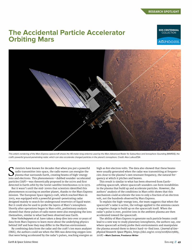
Earth & Space Science News Eos.org // 49
RESEARCH SPOTLIGHT
Scientists have known for decades that when you put a powerful radio transmitter into space, the radio waves can energize the plasma that surrounds Earth, creating beams of high- energy
ions and electrons. This phenomenon—dubbed sounder- accelerated particles (SAP)—was theoretically proposed in the 1970s and first detected in Earth orbit by the Soviet satellite Interkosmos 19 in 1979.
But it wasn’t until the mid- 2000s that scientists identified this phenomenon occurring on another planet, thanks to the Mars Express mission. The European Space Agency craft, which reached Mars in 2003, was equipped with a powerful ground- penetrating radar designed mainly to search for underground reservoirs of liquid water. But it could also be used to probe the layers of Mars’s ionosphere. Shortly after operations began in Mars orbit, preliminary analysis showed that these pulses of radio waves were also energizing the ions themselves, similar to what had been observed near Earth.
Now Voshchepynets et al. have taken a deep dive into over 10 years of data from Mars Express to learn more about the underlying physics behind SAP and how they may differ in the Martian environment.
By combining data from the radar and the craft’s ion mass analyzer (IMA), the authors could see when the IMA was detecting oxygen ions that were being accelerated by the radar’s pulses, reaching energies as
high as 800 electron volts. The data also showed that these beams were usually generated when the radar was transmitting at frequen-cies close to the plasma’s own resonant frequency, the natural fre-quency at which it pitches and heaves.
This result is similar to what has been observed from Earth- orbiting spacecraft, where spacecraft sounders can form instabilities in the plasma that build up and accelerate particles. However, the authors’ analysis of the conditions in Mars orbit shows that this mechanism could accelerate the ions to only a fraction of an electron volt, not the hundreds observed by Mars Express.
To explain the high- energy ions, the team suggests that when the spacecraft’s radar is active, the voltage applied to the antenna causes a negative charge to build up on the spacecraft itself. When the radar’s pulse is over, positive ions in the ambient plasma are then accelerated toward the spacecraft.
The ability of Mars Express to generate such particle beams could lead to a new way to study planetary ionospheres, the authors say, one where spacecraft actively probe their environments and manipulate the plasma around them to detect hard- to- find ions. ( Journal of Geo-physical Research: Space Physics, https:// doi . org/ 10 . 1029/ 2018JA025889, 2018) —Mark Zastrow, Freelance Writer
This artist’s rendering of the Mars Express spacecraft shows the 40- meter- long antenna used by the Mars Advanced Radar for Subsurface and Ionosphere Sounding (MARSIS), the
craft’s powerful ground- penetrating radar, which can also accelerate charged particles in the planet’s ionosphere. Credit: Alex Lutkus/ESA
The Accidental Particle Accelerator Orbiting Mars

50 // Eos July 2019
POSITIONS AVAILABLE
Geodesy
The UNAVCO Board of Directors seeks Applicants to the position of Presi-dent.
Located in picturesque Boulder, Col-orado, UNAVCO is a non- profit corpora-tion that supports and promotes Earth science by advancing high- precision geodetic positioning, timing, and remote sensing for basic research, envi-ronmental studies, environmental monitoring and hazards mitigation. Our membership is composed of interna-tional education, research, and opera-tional institutions with a commitment to scholarly research, outreach and sci-entific application. The recent announcement of retirement by our esteemed President Dr. M. Meghan Miller requires that the UNAVCO Board of Directors fill the position of Presi-dent. The President will report directly to the UNAVCO Board of Directors, which is elected by its membership.
Challenges for UNAVCO’s next Presi-dent: Geodetic science and its applica-tions have become deeply embedded within the mesh of science and society. This expansion of geodetic science and technology has also spurred the need for increasing investments in instru-mentation to improve the resolution, distribution, and reliability of data being delivered to the UNAVCO Community and its many pursuits and applications. UNAVCO is also committed to improv-ing the technical skills and scientific
well- being of its Community while nav-igating within increased political and economic pressures. UNAVCO will have to adapt to this dynamic environment and will need guidance from a President with thoughtful vision and the ability to execute on that vision.
The Board of Directors seeks a dynamic leader with:
o A demonstrated record of excel-lence, vision and leadership in Earth science;
o A broad understanding of the sci-entific and operational applications of geodetic technology in service of basic research, environmental monitoring and hazards mitigation;
o Highly- developed leadership, com-munication, and interpersonal skills to represent UNAVCO in scientific, gov-ernment, and commercial venues;
o A demonstrated ability to promote a diverse and inclusive environment;
o A demonstrated ability to lead, communicate with, and inspire the diverse employees of the facility and to work effectively as a team member;
o A demonstrated ability to promote consensus among researchers and managers with diverse points of view;
o Knowledge of UNAVCO’s sponsor agencies (NSF, NASA, USGS), their sis-ter agencies and associated governmen-tal structures and procedures;
o Strong management skills and business knowledge with a demon-strated ability to lead within a cost and schedule constrained environment;
AIR FORCE SCIENCE & TECHNOLOGY FELLOWSHIP PROGRAMS
Postdoctoral and Senior Research Awards
The Air Force Science & Technology Fellowship Program (AF STFP) offers nationally
competitive fellowship awards to postdoctoral and senior scientists to perform collaborative
research at U.S. Air Force research facilities across the country. Since 1966, the Air Force
S&T Enterprise has hosted over 1,000 fellows under the NRC Research Associateship Programs
and many of these researchers have gone on to successful careers in government laboratories.
The AF STFP continues this tradition of providing high quality research opportunities with
Air Force scientists and engineers at Air Force Research Laboratory, the Air Force Institute
of Technology, and the U.S. Air Force Academy.
We are actively seeking highly qualifi ed candidates including recent doctoral recipients and
senior researchers. Applicants should hold, or anticipate receiving, an earned doctorate in
science or engineering. Applications are accepted during four annual review cycles with
deadlines of February 1, May 1, August 1, and November 1.
Awardees have the opportunity to:
• Conduct independent research in an area compatible with the interests of the
Air Force laboratories
• Devote full-time effort to research and publication
• Access the excellent and often unique facilities of the Air Force
• Collaborate with leading scientists and engineers
Benefi ts of an AF STFP award include:
• Base stipend starting at $76,542, which is increased based on years of experience past
the doctoral degree
• Health insurance
• Relocation benefi ts
• An allowance for professional travel
For detailed program information, visit www.nas.edu/afrl or send an e-mail to [email protected].
The Career Center (findajob.agu.org) is AGU’s main resource for recruitment advertising.
AGU offers online and printed recruitment advertising in Eos to reinforce your online job visibility and your brand. Visit employers.agu.org for more information.
Eos is published monthly.
Deadlines for ads in each issue are published at sites . agu.org/media-kits/eos-advertising-deadlines/.
Eos accepts employment and open position advertisements from governments, individuals, organizations, and academic institutions. We reserve the right to accept or reject ads at our discretion.
Eos is not responsible for typographical errors.
• SIMPLE TO RECRUITu online packages to access our Career Center audience
u 30-day and 60-day options available
u prices range $475–$1,215
• CHALLENGING TO RECRUIT u online and print packages to access the wider AGU community
u 30-day and 60-day options available
u prices range $795–$2,691
• DIFFICULT TO RECRUITu our most powerful packages for maximum multimedia
exposure to the AGU community
u 30-day and 60-day options available
u prices range $2,245–$5,841
• FREE TO RECRUITu these packages apply only to student and graduate student
roles, and all bookings are subject to AGU approval
u eligible roles include student fellowships, internships, assistantships, and scholarships
Packages are available for positions that are

Earth & Space Science News Eos.org // 51
POSITIONS AVAILABLE
o The ability to engage in frequent national and international travel.
Application Details: The minimum term of the employment is negotiable but the expectation is 2-4 years. Appli-cations must include: 1. A complete vita 2. The names and addresses of three or more references 3. A statement outlin-ing the applicant’s vision for UNAVCO, and 4. A statement that addresses past and/or potential contributions to diver-sity, equity and inclusion. Follow this link, https:// unavcocareers . silkroad . com click on President and select “Apply”.
Review of applications will begin immediately and continue until the position is filled. All inquiries and nom-inations are invited via email to: hr@ unavco .org
Please note: We are unable to pro-vide sponsorship for work authoriza-tion. UNAVCO is an Equal Employment Opportunity/Affirmative Action employer.
Interdisciplinary
Assistant Professor (tenure track) in Paleoclimate Sedimentology
The Faculty of Geosciences and the Environment (FGSE) of the University of Lausanne invites applications for a professorship in Paleoclimate Sedimen-tology, to be based in the Institute of Earth Sciences (ISTE).
We are looking for an excellent sedi-mentologist who focuses on the recon-struction of past climate changes
(including sedimentary, paleoclimate, biological and paleoceanography changes) at geological timescales using the stratigraphic and sedimentary record. We seek a candidate who can provide an innovative interpretation of sedimentary archives, using laboratory, and field techniques and reconstructing Earth system history. The ideal candi-date should have a strong background in geology, a strong commitment to field- based research and a willingness to contribute to field- based teaching.
The successful candidate will actively participate in the research activities of the Institute of Earth Sciences, will teach in the Bachelor of Geosciences and Environment and in relevant Mas-ters taught by the FGSE, and will super-vise masters and doctoral students.
Appointment will be at the Assistant Professor level (tenure track). However, exceptionally, we will consider out-standing candidates for direct appoint-ment to the Associate or Ordinary Pro-fessor level, notably if this corresponds with our equal opportunity objectives.
Application deadline: August 24th, 2019
(23:59 Swiss time GMT+2)Details how to apply on: https:// bit .ly/ 2PPF6DaOr www . unil . ch/ central/ en/ home
. html -> Jobs -> search sedimentology
Postdoctoral Research FellowThe Kaçar Lab (ancientbiology.org) at
the University of Arizona seeks to
recruit a Postdoctoral Researcher to study the evolution of metabolic ele-ments related to carbon fixation and photosynthesis in Cyanobacteria. The successful candidate will work on a cross- disciplinary project that com-bines molecular, biochemical and sys-tems level analyses to investigate ancient proteins and microbial commu-nities that are of metabolic and biogeo-chemical importance.
Our lab works at the interface of molecular evolution, synthetic biology, biochemistry, origins of life and astro-biology. We aspire to resurrect ancient proteins and synthetically engineered metabolisms as proxies for ancient bio-geochemistry.
We are interested in outstanding appli cants with the following qualifica-tions:
• Formal Training in Earth or Biolog-ical Sciences with emphasis on geobiol-ogy or microbiology
• Research experience in microbial culturing of microbes, preferably in molecular biology and genomics
• Research experience in stable iso-tope probing is highly preferred
To apply: Submit to Ross Monasky the following via email ( rmonasky@ email . arizona . edu):
• Cover letter describing your expe-rience, training, expertise and motiva-tion
• CV with a publication list
• Names and contact information for 3 references
• Include “ CYANOPD” in the Subject line
The project is funded by the National Science Foundation, available immedi-ately and covers full salary and bene-fits.
Outstanding UA benefits include health, dental, and vision insurance plans; life insurance and disability pro-grams; paid vacation, sick leave, and holidays; UA/ASU/NAU tuition reduc-tion for the employee and qualified family members; state retirement plan; access to UA recreation and cultural activities; and more. The University of Arizona has been listed by Forbes as one of America’s Best Employers in the United States. World at Work and the Arizona Department of Health Services have recognized us for our innovative work- life programs.
Ocean Sciences
Coordinator & Instructor/Asst. Teach-ing Professor, Hydrographic Science
The School of Ocean Science and Engineering (SOSE) at The University of Southern Mississippi (USM) invites qualified applicants for a full-time, 12-month, position as Coordinator & Instructor (or Assistant Teaching Pro-fessor, if holding a terminal degree) of the Hydrographic Science B.S. and M.S. programs in the Division of Marine Sci-ence. These two programs are recog-nized at the Category B and A levels,
JEFFERSON SCIENCE FELLOWSHIP
The National Academies of Sciences, Engineering, and Medicine is pleased to announce
a call for applications for the 2020 Jefferson Science Fellows (JSF) program. Initiated
by the Secretary of State in 2003, this fellowship program engages the American
academic science, technology, engineering and medical communities in the design and
implementation of U.S. foreign policy and international development.
Jefferson Science Fellows spend one year at the U.S. Department of State or the
U.S. Agency for International Development (USAID) for an on-site assignment in
Washington, D.C. that may also involve travel to U.S. foreign embassies and/or missions.
The fellowship is open to tenured, or similarly ranked, academic scientists, engineers,
and physicians from U.S. institutions of higher learning. Applicants must hold U.S.
citizenship and will be required to obtain a security clearance.
The deadline for applications is October 31, 2019 at 5 PM EST. To learn more about the
Jefferson Science Fellows program and to apply, visit www.nas.edu/jsf.
The Jefferson Science Fellows program is administered by the National Academies of Sciences,
Engineering, and Medicine and supported by the U.S. Department of State and the United States Agency
for International Development.
NRC RESEARCH ASSOCIATESHIP PROGRAMS
The National Academy of Sciences, Engineering, and Medicine offers postdoctoral and senior
research awards on behalf of 23 U.S. federal research agencies and affi liated institutions with
facilities at over 100 locations throughout the U.S. and abroad.
We are actively seeking highly qualifi ed candidates including recent doctoral recipients and
senior researchers. Applications are accepted during four annual review cycles (with deadlines
of, August 1, November 1, February 1, May 1).
Awardees have the opportunity to:
• conduct independent research in an area compatible with the interests of the
sponsoring laboratory
• devote full-time effort to research and publication
• access the excellent and often unique facilities of the federal research enterprise
• collaborate with leading scientists and engineers at the sponsoring laboratories
Benefi ts of an NRC Research Associateship award include:
• 1 year award, renewable for up to 3 years
• Stipend ranging from $45,000 to $80,000, higher for senior researchers
• Health insurance, relocation benefi ts, and professional travel allowance
DESIRED SKILLS AND EXPERIENCE
Applicants should hold, or anticipate receiving, an earned doctorate in science or engineering. Degrees from universities abroad
should be equivalent in training and research experience to a degree from a U.S. institution. Some awards are open to foreign
nationals as well as to U.S. citizens and permanent residents.
ABOUT THE EMPLOYER
The National Academies of Sciences, Engineering, and Medicine’s Fellowships Offi ce has conducted the NRC Research
Associateship Programs in cooperation with sponsoring federal laboratories and other research organizations approved for
participation since 1954. Through national competitions, the Fellowships Offi ce recommends and makes NRC Research
Associateship awards to outstanding postdoctoral and senior scientists and engineers for tenure as guest researchers at
participating laboratories. A limited number of opportunities are available for support of graduate students in select fi elds.
Apply at www.nas.edu/rap.

52 // Eos July 2019
POSITIONS AVAILABLE
respectively by the International Hydrographic Organization, the Inter-national Federation of Surveyors, and the International Association of Car-tographers. SOSE includes two aca-demic divisions, Marine Science, and Coastal Sciences, and several R&D cen-ters including: Hydrographic Science Research Center, Center for Fisheries Research and Development, and Thad Cochran Marine Aquaculture Center. The Division of Marine Science is based at the NASA Stennis Space Center where Marine Science faculty benefit from close working relationships with a number of on-site federal agencies, including the Naval Research Laboratory- Stennis Space Center, the Naval Oceanographic Office, the Naval Meteorology and Oceanography Com-mand, the USGS and NOAA, including the National Data Buoy Center.
Applicants must hold a M.S. degree in hydrography, oceanography, or a related field with 5 years or more of hydrographic surveying experience. Preference will be given to candidates with a Ph.D. in hydrography, oceanog-raphy, or a related field and post- doctoral experience, and a demon-strated record of service, grant development, communication, and commitment to diversity. The candi-date is expected to coordinate, execute, and continue to develop a comprehen-sive academic program in hydrogra-phy, at the undergraduate and gradu-
ate level, in accordance with International Hydrographic Organiza-tion (IHO) standards. The undergradu-ate program is a 4-year curriculum providing a Bachelor of Science degree in Marine Science with emphasis in Hydrography. The graduate program is an intensive 1-2 year curriculum with significant classroom coursework and field exercise, including a capstone project. The successful candidate is expected to develop and deliver courses in hydrography and related sciences and should demonstrate the potential to contribute across disciplines and promote the continued interdisciplin-ary growth of the academic and research programs within the SOSE. The candidate can expect to be involved in research activities with the Hydrographic Science Research Center, but the primary focus of this position is teaching. Salary packages will be nationally competitive and commen-surate with experience. Applications must be submitted online at https:// jobs . usm . edu. For inquiries about the position, contact Stephan Howden, Chair of the Search Committee, at 1-228- 688- 5284 or Stephan . howden@ usm . edu. Review of applications begins 1 May 2019 and continues until the position is filled, with an anticipated start date of August 2019.
The University of Southern Missis-sippi is an Equal Opportunity/ Affirma-tive Action Employer.
PLACE YOUR AD
HEREVisit employers.agu.org to learn more about
employment advertising with AGU

POSTCARDS FROM THE FIELD
View more postcards at bit.ly/Eos_postcard
Hello, AGU!
Things are going great in our hand-dug paleoseismic trench across the valley from the Teton Range in Wyoming. All day we are treated to a spectacular view of Grand Teton and friends, but the morning light is especially stunning.
Our main goals are to understand the earthquake history recorded in this fault scarp. This information will be combined with other trench data along the main Teton fault and used in seismic hazard analyses.
In the photo, from left to right, Ryan Gold, Maddie Hille, and Chris DuRoss enjoy the shade while they discuss the latest observations.
—Jaime Delano, U.S. Geological Survey, Golden, Colo.
POSTCARDS FROM THE FIELD

agu.org/fallmeeting
Abstract SubmissionsNow Open