100 years of lost river - forest society · with a great selection of forest society shirts,...
TRANSCRIPT

100 Years ofLost River
Broadening Monadnock’s
Shoulders
0 974470 25172
2 3 >US $4.95
SUMMER 2012
forestsociety.org

WINDOWS TO THE WILDJOIN THE ADVENTURE
THURSDAYS 8:30PMNHPTV.ORG
WWINDO
O THE WILDS TWJOIN THE
O THE WILDJOIN THE VENTUREAD
VENTURE
THURSD
S 8:YYS 8:AAYTHURSDNHP
03 PMORG.TVV.NHP
Show your support for land conservation in New Hampshire in style with a purchase from the Forest Society’s online gift shop!
With a great selection of Forest Society shirts, jackets, hats, tote bags, jewelry, and more — there’s something for everyone.
Wear them with pride, or give them as gifts to your friends and family.
All pro�ts go to support the Forest Society’s land conservation mission.
Visit www.forestsociety.org/giftshop today!
Or, if you’re in the area, drop by our gift shop at the Conservation Center in Concord.
Caps, apparel, jewelry, totes, and more.Take the Forest Society with you.
www.forestsociety.org/giftshop

TABLE OF CONTENTS: SUMMER 2012, No. 271
27
22
4FEATURES4 Finding Lost River
By Lorna Colquhoun
The Forest Society acquired Lost River a century ago and it remainstoday as our oldest forest reservation. It also hosts thousands of visitorseach summer to explore one of New Hampshire’s unique naturalwonders.
8 The Legacy of the Lost River Guides10 Enjoying Lost River Today11 Lost River 100th Anniversary Events
12 Farming through the Ages at MusterfieldBy Dave Anderson
Thanks to a visionary landowner, a dedicated community, and a conservation easement, this historic Sutton farm remains productive today.
16 Recalling a Memorable CompromiseBy Jack Savage
The statewide battle over the proposed Northern Pass project is reminiscent of another long-term struggle to protect the state’sclosely held scenic values in Franconia Notch.
DEPARTMENTS2 THE FORESTER’S PRISM
Celebrating Lost River
3 WOODPILENews not so neatly stacked
17 ANNUAL MEETINGCelebrating the Monadnock Region
18 IN THE FIELDHikes and walks, lectures, art, and more
20 WOODS WISEBunny business in the forest
22 CONSERVATION SUCCESS STORIESExpanding Monadnock’s conservation landscape; preserving an agricultural oasis in the Seacoast; protecting a black gum swamp;mountaintop legacy conserved, and more
29 HEARD ON THE TRAILThe lake, the land, and the people who love them: a Newfound Lakesuccess story
30 NATURE’S VIEW Lost River: a gift from the glaciers
32 PROJECTS IN PROGRESSHelp the Forest Society conserve Hazelton Farm
On our cover:
Descending into the magical Lost River Gorge. Photo by Jerry and Marcy Monkman, Ecophotography.

Society for the Protection of New Hampshire ForestsA non-profit membership organization founded in 1901 to protect the state’s most important landscapes and promote wise use of its renewable natural resources. Basic annual membership fee is $35 and includes a subscription to Forest Notes.
Editor: Jack SavageManaging Editor: Joyce El KouartiDesign & Production: The Secret AgencyPrinting: TDS Printing
Forest Notes is published four times a year and printed on elemental chlorine-free Sappi Flo paper with 10 percent post-consumer recycled content. Sappi Flo is made from pulp purchased from suppliers who document sound environmental practices and sustainable forest management.
Permission is required for reproduction of any part of this magazine.
Copyright 2012 SPNHF. US ISSN: 0015 7457.
54 Portsmouth Street, Concord, NH 03301 | Phone: (603) 224-9945 | Fax: (603) 228-0423 E-mail: [email protected] | Internet: www.forestsociety.org
The Forest Society proudly supports the following organizations:
Cosponsor MemberUnderwriter
THE FORESTER’S PRISM
It wasn’t long after the Forest Societyhelped pass the Weeks Act in 1911 enabling the establishment of the
White Mountain National Forest that weturned to protecting other fabled specialplaces in New Hampshire. In fact, by late1911 we were conducting one of our earlyfundraising campaigns in order to acquireand protect Lost River Gorge—even then an increasingly popular natural tourist attraction—and in 1912 we took ownership.We still own it today.For many years we operated Lost River
ourselves, welcoming thousands of peopleinto the Gorge to experience the beauty ofParadise Falls and mystery of caverns likeDevil’s Kitchen and The Center of the Earthfor themselves. The gift shop stands in theoriginal Rollins picnic shelter, donated a century ago by Forest Society founder Gov.Frank West Rollins’ family. Today we partnerwith White Mountains Attractions to manage the tourism aspect of the popularsite, with a percentage of the proceeds supporting our conservation mission. More important, Lost River is a place
where thousands of people—especially chil-dren—are introduced to New Hampshire’soutdoors as a place to learn and have fun.
It’s a place that can instill appreciation for the wonders of natureand foster a conserva-tion ethic in the nextgeneration. It’s a placewhere adults can feellike a kid again, slither-ing through the murkyconfines of the Lemon Squeezer.The work we do today depends on the
ongoing support of those who love NewHampshire’s outdoors. Your membership includes two passes to Lost River—we encourage you to use them. Take a friend orrelative. Use our history and one of NewHampshire’s special places to build a founda-tion for conservation in the future.
Jane Difley is the president/forester of the Societyfor the Protection of New Hampshire Forests.
Paradise ProtectedCHAIRCarolyn Benthien, Goffstown
VICE CHAIRWilliam Webb,Holderness
SECRETARYMidge Eliassen, Sunapee
TREASURERLeonard “Hunt” Dowse, Hancock
PRESIDENT/FORESTERJane A. Difley, Webster
BOARD OF TRUSTEESMalin Clyde, DurhamKatharine Eneguess, JaffreyPamela Hall, PortsmouthDeanna Howard, EtnaWilliam McCarten, LancasterAmy Meyers, JaffreyJack Middleton, FreedomHoward Moffett, CanterburyWilliam H. Smith, MoultonboroughHank Swan, LymeStephen Taylor, MeridenBill Tucker, GoffstownPatricia Vasbinder, ConcordDon Wharton, Landaff
STAFFEXECUTIVEJane A. Difley, president/foresterKaren Rose, executive coordinator/land protection associate
FINANCE/ADMINISTRATIONMartha Booth, receptionistMichelle Morse, human resources specialistTina Ripley, administrative assistantLeslie Thompson, finance specialistDenise Vaillancourt, vice president, finance
MEMBERSHIP/DEVELOPMENTDiane Forbes, senior director for developmentNancy Ford Huckins, membership specialistSusanne Kibler-Hacker, vice president, developmentAllan Krygeris, technology specialistMargaret Liszka, director, membershipAnn McCoy, membership coordinatorMeredith Reed O’Donnell, development associateMartha Twombly, development specialist
COMMUNICATIONS/OUTREACH PROGRAMSDavid Anderson, director, education and volunteersCarrie Deegan, land steward program specialistJoyce El Kouarti, communications directorJack Savage, vice president, communications/outreach
POLICY/LAND MANAGEMENTWill Abbott, vice president, policy/land managementFrank Allen, building and grounds assistantClare Brown, volunteer coordinatorRita Carroll, land management and policy assistantGeorge Frame, senior director of forestryNigel Manley, director, north country propertyCarleen Quinn, gift shop and program managerJason Teaster, property managerWendy Weisiger, field foresterChris Wells, senior director for strategic projects—policy
LAND PROTECTIONJoslin Bennett, easement stewardChris Borg, land protection specialistPaul Doscher, vice president, land conservationPaul Gagnon, easement stewardBrian Hotz, senior director for strategic projects—land protectionTom Howe, senior director, land conservationLori Johnson, land protection assistant/data base managerLauren Kras, easement stewardMichael Speltz, land protection specialistDaniel Sundquist, director, land conservation planningRyan Young, director, easement stewardship

Summer 2012 FOREST NOTES | 3
THE WOODPILE—NEWS NOT SO NEATLY STACKED
By Jack Savage
50 years ago in Forest Notes“Education in outdoor manners is of prime importance if
much real pleasure and the true re-creation of the spirit whichso many earnestly seek as essential relief from our noisy andwearing urban life are to be preserved.” So wrote Forest SocietyForester Lawrance W. Rathbun in the Summer 1962 issue of ForestNotes. It was a time when more and more people were looking tofind such “essential relief”, and Rathbun opined that whilelandowners should be generous in allowing public recreation,“…use respectful of others’ rights is even more important.”
The Summer 1962 cover photo featured Pawtuckaway Lake, then describedas a ‘proposed state park.’
Zankel HonoredThe Forest Society recently honored Contoocook resident Mark Zankel with
the Sarah Thorne Conservation Award. The award is presented annually to a conserva-tion professional or volunteer who has made a major contribution to the protection ofthe New Hampshire landscape at a local, regional, or statewide level.Zankel has served in both a professional and volunteer capacity in New Hampshire’s
conservation community for nearly 18 years. He guided and inspired a staff of 15 peoplewithin the NH Field Office of The Nature Conservancy (TNC) and lent his expertise tonumerous collaborative projects and conservation planning efforts. He contributed to the scientific underpinnings of the largest land protection project in modern NewHampshire history, the Connecticut Lakes Headwaters, and he was a leader in the creationof the State’s Coastal Conservation Plan and the Ashuelot River Conservation Plan.
Policy UpdateAn article on page 32 of the Spring 2012
issue of Forest Notes contained two errors.First, legislation proposed by Senator JeanieForrester to study the feasibility of buryinghigh voltage power lines under existingstate-owned transportation corridors (SB361) was not then enacted; a separateamendment to HB 648—an amendmentintroduced by Senator Sylvia Larsen—wasenacted. SB 361 has since been passed byboth the House and Senate. The seconderror was the report that a second bill introduced by Senator Forrester—SB 215 toamend the existing statute governing theNew Hampshire Site Evaluation Commit-tee—had been enacted. The bill was, andremains at this writing, under considera-tion by the Legislature.
The US Dept. of Agriculture is hoping NOT to catchany of the invasive beetle from China known as the emerald ash borer in traps such as these. Thetraps are part of the Cooperative Agricultural PestSurvey Program coordinated by the USDA Animaland Plant Health Inspection Service (APHIS) in collaboration with the NH Dept. of Agriculture,Markets and Food. The emerald ash borer is a smallmetallic-green beetle that kills ash trees (Fraxinus)by tunneling through the cambium layer of the treetrunk or stem. The emerald ash borer has no knownnatural enemies, and it has not yet been detected in New Hampshire.
Why do New Hampshire landowners own their land? Beauty/Scenery lead the reasons.Although few landowners say that timber production is a reason for owning land, 53 percent of landowners report having conducted a harvest on their land for one reasonor another. (Courtesy Karen Bennett and Tim Fleury, UNH Cooperative Extension)
Reasons for Owning(Greater Than 10 Acres)
0% 20% 40% 60% 80%
Timber production
Land investment
Legacy
Hunting/recreation
Nature/biodiversity
Privacy
Beauty/scenery
Family forests, New HampshireEngaginglandowers.org, 2006

4 | FOREST NOTES Summer 2012
Finding
Lost RiverBy Lorna Colquhoun

Summer 2012 FOREST NOTES | 5
The maze of rocks and water that are Lost River was formed 150,000 years agoduring an Ice Age that brought with it swaths of glaciers. A mile or more thick,the glaciers spent 125,000 years moving southeastward over the White Moun-tains grinding, lifting, and depositing the rocks that carved and slashed thelandscape. Photo by Jerry and Marcy Monkman, EcoPhotography.
After hundreds of millions of years of being shaped by theforces of nature, the grinding stopped, the earth warmed, theIce Age evaporated, and the last boulders in a rugged corner ofNew Hampshire slipped into place.
And then water began to flow, splashing over and tumblingunder those enormous rocks on its way to a larger river, to becarried down to the sea.
About 25,000 years later, two curious boys would stumbleupon this maze of rocks and water, proclaiming they had foundLost River, a wonder that would be rivaled only by a neighboringrock formation on the other side of the ridge.
“A careful examination of this hidden wonder of nature’s mysterious and prehistoric convulsion reveals wonders
second to none in our state of its nature and no other naturalwonder, unless it is the Old Man of the Mountain.”
– The Granite Monthly, August 1912
Adventurous visitors and timber barons would soon follow,and the interests of the two would prompt a preservation effortthat today, 100 years later, keeps open a geological portal intothe distant past. This year marks the centennial anniversary of the summer that the Forest Society succeeded in acquiringLost River and securing Kinsman Notch from being ravaged byunsustainable logging.


Summer 2012 FOREST NOTES | 7
In the BeginningThe history of Lost River is literally written in stone. Born 300
million years ago under the sea that covered the earth, the primor-dial ooze was heated and folded and cooled, heaved and foldedinto mountains. The Ice Age brought with it swaths of glaciers 150,000 years ago.
A mile or more thick, the glaciers spent 125,000 years movingsoutheastward over the White Mountains, grinding, lifting, anddepositing rocks that carved and slashed the landscape. When the ice finally melted, the water carried debris, eroding
the rocks and forming the Lost River Gorge. It cut through and smoothed the rocks, carving out basins and potholes, leavingbehind waterfalls and wonder. Legend picks up Lost River’s story in 1852, when brothers
Lyman and Royal Jackman headed up into Kinsman Notch insearch of a fishing hole, most likely what we know today as theBeaver Pond, at the height of land. Poking their way upstream,Lyman suddenly dropped from sight, landing 15 feet lower in anunderground pool now called Shadow Cave.
A Natural AttractionOver the years, the boys would return to the gorge, exploring
the caves and spreading stories that began drawing visitors frombeyond Woodstock.The first organized excursion was an 1874 trek by guests of the
House of the Seven Gables in North Woodstock comprised of fourmen and three women. The group, according to local history,spent two days in subterranean discovery, and the collective accounts soon captivated newspaper audiences in distant cities. “For one-half mile, the stream plays hide-and-seek in the dusky
chambers and under piled-up boulders before it leaps out, laugh-ing into the air. Into that one-half mile is crowded more beauty,more grandeur and desolation and wild loveliness than brushescould paint or words could describe if they worked for 20 life-times,” according to a 1874 newspaper account. But it wasn’t until1893, when Royal Jackman guided visitors to the gorge more than40 years after his first exploration, that the name was proclaimed.“This,” Royal Jackman said, “is where my brother found the lost
river.” Three years later, Frank Carpenter and local historian Elmer
Woodbury, who would later become a devoted public servant,went through each and every cave, naming them all and paintingthose names, largely inspired by Greek mythology, on the rocks.Those names, like Elysian Land, the Judgment Hall of Pluto, theCave of Odin, and the Falls of Proserpine, remain today.
Other names, like the Cave of the Lost Souls, Journey to theCenter of the Earth, Devil’s Kitchen, and the Hall of Ships, evokethe spirit of Jules Vern and even Indiana Jones.
Threatened by Private Interests By the turn of the 20th century, townspeople in Woodstock and
Easton decided it was time to establish a road through the notch.In 1903 the state put some money toward it, but by 1905, timbercompanies, with an eye on the thick, untouched forest, moved into harvest, and the roadwork came to a halt. Visitors to Lost River during the logging operations were as
devastated as the land. “On arrival at the point in the road wherewe must leave for the gorge, we found ourselves in the midst of awilderness of devastation, dead treetops, felled logs, and a networkof abandoned log roads. Our cup of indignation was full when irresponsible parties built a shack, wherein to exploit the travelers’hunger, thirst, ignorance, or other weaknesses,” according toWalks and Climbs in the White Mountains, 1926.
The Forest Society to the RescueIn 1908, concerned with the rapacious logging, the Forest Society
began negotiating with the timber contractors and raising moneyto buy 147 acres that included Lost River. The organization took its plea to the public. “The Kinsman Notch is one of great dignity and beauty, equal-ing the other famous notches in the state. The Publisher’sPaper Co. will donate the river and 150 acres … provided theSociety will buy the standing timber on the tract, whichamounts to $7,000.” — Forest Society flyer, 1911
Opposite page: Although the forces that have carved and shaped Lost RiverGorge continue to write its history, Lost River is largely the same now as it was the day Lyman Jackman dropped into Shadow Cave in 1852. Shown here,Paradise Falls. Photo by Jerry and Marcy Monkman, EcoPhotography.
Right: By the early 1900s, the Jackman brothers were guiding visitors to thegorge on organized tours. Early postcard from Forest Society archives.
Through the leadership of Forest Society forester Philip Ayres,combined with $5,000 bequeathed from the estate of Dora Martinof Dover and the remainder raised by local hotels, there wasenough money to buy the land. In July 1912, the governors of the New England states attended
the annual forestry meeting at the Mount Washington Hotel inBretton Woods. They would visit Kinsman Notch and “the famousLost River region,” according to an account in the New York Times,and at the meeting, “It will be determined to purchase and conserve these most remarkable of the scenic glories of the WhiteMountains. “It is the purpose of the Publishers’ Paper Company to givein fee … the 148 acres of land through which Lost River runsto the Society for the Protection of New Hampshire Forests,provided that the Society succeeds in raising sufficient fundswith which to purchase from them the standing timber.More money is needed to cover the expenses of clearing upthe slash and waste timber left lying by the lumbermen.” — The New York Times, July 14, 1912 Later that week, the influential leaders of the day, including
Mrs. Grover Cleveland, Gov. Robert P. Bass, two ex-governors, andnow-Capt. Lyman Jackson attended a gala at the Deer Park Hotel inNorth Woodstock to toast the success of the Forest Society on theacquisition of the Lost River Reservation and to look to the future.“The one important link now needing welding in order to
make the chain of development complete is for the state to aid incompleting the road begun a few years ago,” reported The GraniteMonthly in August 1912. “When this is done, the beautiful butneglected Kinsman Notch will come into what has rightfully belonged to it for years.”Development of the notch would be largely confined to creating
a state road through it, connecting Woodstock with the westernside of New Hampshire.
(Read more about the details of the Forest Society’s efforts toprotect Lost River in “Nature’s View” on page 30.)
New Life for an Old GorgeNow under the ownership of the Forest Society, Edward Rollins,
the brother of former Gov. Frank Rollins, gave money to build a shelter, restaurant, and gift shop. This sturdy structure, with amassive stone fireplace, remains today. Funds were also provided sothat trail crews from the Appalachian Mountain Club, includingfuture governor Sherman Adams, could improve access to thegorge. (See the story on p. 9 about the early Lost River guides.)Visitors continued to come and be inspired by what many con-
sidered the second wonder of New Hampshire. In his 1913 address,lamenting the end of school days no one will forget, Nashua’sMount Pleasant School valedictorian David Eaton began hisspeech, “I have taken as my subject, ‘A Trip to One of the GreatestNatural Wonders of New Hampshire’” and told of the adventureand beauty of the wild place, analogous to the succeeding chap-ters of their lives.“Let us place for ourselves a trail broad and straight throughthe great world of opportunity … the great prizes of theworld are reserved for the enterprising, for those who havethe courage to dare and the will to do. Let our principles beas our granite, our aspirations like our mountains, and oursympathy swift and far reaching as our rivers.” — The Nashua Telegraph, June 21, 1913.
Lorna Colquhoun has been writing and reporting about New Hamp-shire’s North Country for many years. A former editor of the CoosCounty Democrat, she reported extensively as a correspondent for theNew Hampshire Union Leader newspaper. She lives in Franconia.
8 | FOREST NOTES Summer 2012
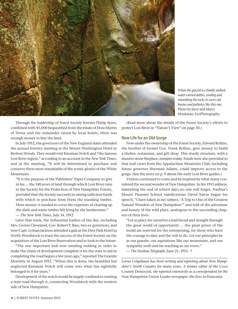
When the glacial ice finally melted,water carried debris, eroding andsmoothing the rocks to carve outbasins and potholes like this one.Photo by Jerry and MarcyMonkman, EcoPhotography.

With a road in place winding through Kins-man Notch, visitors began following it to LostRiver to see what was touted as one of NewHampshire’s natural wonders.
They followed a boardwalk laid out throughthe gorge and climbed ladders placed for thehardy to crawl into and out of the caves. Forthose early travelers, the experience was not asit is now, for they had to gear up in coverallsand be prepared to get dirty.
To assist them, guides were employed, typically college boys with a love of adventureand the outdoors. They lived in a bunkhouse,and their duties ranged from taking tickets anddispatching parties of explorers to washingcoveralls and overseeing the grounds.
“One of the great charms of Lost River in theearly 1960s, both for the tourists and for usguides, was the lack of commercialism,” saidDavid Nelson of Reading, Mass., a guide from1959 to 1962, the 50th anniversary year.“Tourists appreciated the fact that we ran organized, one-hour tours for small groups,that we used candles instead of electric lights,and that there were few signs. We encounteredmany interesting people.”
The social center of activity for the guides,Nelson said, was the guide shack, where theyoung men read and chatted. Off duty theyhiked, often up to the top of Mount Moosilauketo the Dartmouth Outing Club hut.
“It was not uncommon for the guides tohike to after the evening meal, stay the nightand come down before breakfast,” according toa remembrance of a 1937 guide.
Among the strapping lads arose their competitive natures, with a record of 50 minutesone year hiking from Lost River to the Moosi-lauke summit.
After hours, they would also spend timecrawling through rocks “to which the publicwas not invited,” according to archival remem-brances.
“The friends, particularly the girlfriends,
were treated at night by candlelight to crawlswith such names as ‘Fat Man’s Misery,’ ‘the Nutcracker’ and the ‘Bobby Buster,’“ accordingto a guide’s account of life in the notch. “Soft-ball was played on the highway in the evening;into the woods was out. Outs were frequent.”
In the late 1930s, a musical group wasformed, the Micro-cephalic Musical Melodra-matic Mummers. It was part bottle band andpart ensemble, with typical band instrumentssupplemented by the odd washboard.
“Often we would just take advantage of anevening’s peace and quiet to read or just tocontemplate life and our unknown futures,”Nelson said.
Friendships made each summer at LostRiver often spanned lifetimes. In a 1987 remembrance, H.E. Laurence, a guide for twosummers in the late 1930s as he studied to be a doctor, told of a party from Michigan thatincluded the physician-in-chief at Henry FordHospital in Detroit.
“That’s how I got my internship,” Laurencewrote.
Fifty years later, he wrote six pages describ-ing all that Lost River meant to him; “two of thebest summers I ever had,” a knowledge and appreciation of birds, and a love of mountainsand hiking.
“Last, but by no means least, the friendshipin Gil Knowles,” he wrote, referring to the manwho founded the Nature Garden at Lost Riverand who spent many summers working there.“Gil eventually left Lost River and returned tothe family home in Epsom to help run the familybusiness. He became my patient and I moni-tored his health for the rest of his life.”
Remembrances of the early guides at LostRiver are full of affection and even longing fordays that were carefree and fun.
“I never get tired of the place,” the lateDwight Taylor of Franconia said in a 1987 news-paper article. “I can’t explain it, but it’s such aspecial place.”
A 1952 newspaper article concluded, “Theboys tell of Lost River with a reverence that enhances its awe-inspiring beauty.”
LOST RIVER GUIDES REVELED IN OUTDOORS, CAMERADERIE
By Lorna Colquhoun
“The guides are usually students representing the leading universities of New England. They are uniformly young men of good character and courteous in every way.”
— Lost River and Going Through It, 1925
Early Lost River guides followed a boardwalk laid out through the gorge and climbed ladders placed forthe hardy to crawl into and out of caves. Forest Society archive photo.
Summer 2012 FOREST NOTES | 9

Left: The nostalgia of caves still lit by lanterns remains.
Right: Sturdy boardwalks meander through the gorge, set in a way that allows those who prefer to bypass the caves to do so.
100 Years Later — Enjoying Lost River Gorge TodayBy Lorna Colquhoun Photos by Jerry and Marcy Monkman, EcoPhotography.
Although the forces that have carved andshaped the gorge continue to write its history,geologically, Lost River is largely the same nowas it was the day Lyman Jackman dropped intoShadow Cave in 1852. Its ongoing preservationas one of the wonders of the Granite State hasevolved over the past 100 years, since the ForestSociety stepped in to save it and Kinsman Notchfrom wide-scale logging that would have madethis special place very different.
More than just an experience, a visit to LostRiver today is a peek into a timeless wonder for the visitors who pause along the way. It offersa bridge between the generations in this ever-changing world, where parents and grandparentsbring children and grandchildren to share thefond memories of a place that has remained vir-tually unchanged by man over the last century.
Visitors no longer have to change into cover-alls before going through the gorge and caves,thanks to the installation of a boardwalk; nowcomfortable shoes and a sense of adventure are the only accompaniments required to expe-rience the beauty of Paradise Falls or take on the challenge of wiggling through the LemonSqueezer or the Dungeon.
The sturdy boardwalks meander through the gorge, set in a way that allows those whoprefer to bypass the caves to do so. One can onlyimagine the hands that have passed over thehandrails, leaving them smooth and taking fromthem a story or a photograph.
Throughout the season, school groups andsummer camp kids enjoy Lost River as an out-door classroom, where they not only find it, butalso learn about the history, the geology, theplant and wildlife, all of which enhances their understanding of how the world came to be.
The success and popularity of Lost River asone of the draws to the region comes from theForest Society’s partnership with White Moun-tains Attractions. Since 1967, the association,headquartered down the road in North Wood-
stock, has managed the daily operations of LostRiver Gorge and Boulder Caves.
Together the Forest Society and White Moun-tains Attractions complement each other, tyingtogether seamlessly the interests of preservationand education and introducing a beautiful placeto visitors from around the world.
“In today’s fast paced technological world, awalk through Lost River offers a bridge betweenages,” said Deb Williams, manager of Lost RiverGorge. “While the boardwalks have been improved to protect the fragile environment, thenostalgia of caves still lit by lanterns remains.”
On this centennial anniversary year of ForestSociety ownership of Lost River, visitors can explore a new trail that takes them above thegorge, passing an old-growth tree, a giant pot-hole, and a vernal pool. New signs that includecave maps, photos, and a timeline offer visitors awindow on Lost River's geological history, fromits formation to the present day.
If you close their eyes and simply listen, you hear the elemental sounds of the ages, therushing water and wind whispering through the trees—two things that have not, nor willever, change.
10 | FOREST NOTES Summer 2012
Below: The caves of Lost River have names, suchas the Cave of the Lost Souls, Journey to the Centerof the Earth, Devil’s Kitchen, and the Hall of Ships (shown here) that evoke the spirit of Jules Vern andIndiana Jones.

Summer 2012 FOREST NOTES | 11
Lost River Gorge and Boulder Caves Events
In celebration of 100 years of conservation by the Forest Society. All events take place at Lost River Gorge & Boulder Caves
1712 Lost River Road, Route 112W, North Woodstock. For more information or to register, contact (603) 745-8031 or [email protected].
SATURDAYS | 7:30 – 9 pm
June, July, August: Saturday Evening Lantern ToursLost River is astonishing during the day andbecomes a whole new adventure at nightwhen the caves are lit by lanterns andboardwalks by headlamps. This guidedlantern tour takes about 1.5 hours and begins between 7:30-8:00 pm on Saturdaysonly. When we are finished exploring, we’llgather around the campfire for s’mores. By reservation only; space is limited. $27 per person.
THURSDAYS | 7 – 8 pm
July & August: Evening Program SeriesJoin White Mountains New Hampshire foran educational evening series. Topics willconcentrate on Kinsman Notch and theLost River area, with guest speakers focus-ing on history, ecology, forestry, andwildlife. For more information, visitwww.findlostriver.com.
July 5: Geology (speaker TBD)
July 12:Mike Dickerman on Kinsman Notch
July 19: Dave Anderson from the Forest Society on Old Growth Forests (See detailed description above.)
July 26: Ben Kilham on Black Bear Behavior
August 2: Rick and Carolyn Hunt, theLaughing Couple, on Abenaki Storytelling
August 9: Squam Lakes Natural ScienceCenter staff on NH Wildlife
August 16: Dick Fortin from Tin Mountainon Logging in NH’s White Mountains
August 23: Lost River guides from the pasttell stories around the campfire
August 30: Historical Musician Bob Kilhamrecreates the sights and sounds of mid19th-century America
TUESDAYS AND WEDNESDAYS | 2 – 4 pm
September and October: Special Guided ToursJoin us for a guided tour through Lost RiverGorge. In addition to climbing, crawling,and squeezing in and out of the 11 bouldercaves, the guides will share the natural andcultural history of the gorge. This tour is included in the cost of general admission,but space is limited to the first 25 people.
SUNDAY | All Day
October 14: End of Season CelebrationLost River Gorge has been protected by the Forest Society for 100 years. Join us incelebrating the end of our special centen-nial season. FREE admission for thosedressed in costume, including overalls andflat caps. Live entertainment, plus end-of-season sales in the gift shop.
THURSDAY JULY 19 | 6 to 8 pm
The Protection of Lost River in 1912 and the Role of Primeval (Old Growth) Forest
Join Forest Society Director of Education and Volunteer ServicesDave Anderson on a strenuous, fast-paced, off-trail hike to see some ofthe oldest trees at Lost River. Explorerelict stands and small fragments ofold-growth forest that are exceed-ingly rare in New Hampshire andlearn about the important historicalrole that such primeval trees playedin early Forest Society land conserva-tion campaigns. You’ll also hear thestory about how the Forest Societyprotected Lost River Gorge and Boul-der Caves. Hike begins at 6 pm sharpand will be followed by an indoorlecture from 7-8 pm.
Explore fragments of old-growth forest that are exceedingly rare in New Hampshireand learn about the important historicalrole that these primeval trees played in early Forest Society land conservationcampaigns. Photo by Laura Alexander.

Thanks to a visionary landowner, a dedicatedcommunity, and a conservation easement, thishistoric Sutton farm remains productive today.By Dave Anderson
Farming through the Ages at Musterfield

Summer 2012 FOREST NOTES | 13
L ike much of central New Hampshire, if you were to surveyrural Sutton from above, a rare emerald patch of open fieldswould catch your eye. Compared to the rich alluvial flood-
plains along the Contoocook, Merrimack, and Connecticut Rivers,the upland hill country is not well-endowed with pasture, hayfields, and tillage. Rolling, shady foothills and narrow, flashy rivervalleys are all now re-cloaked by forests long after the peak of theAgrarian Age. It’s rare to discover open hill farm landscape surrounding the
site of an early settler’s original homestead not only intact, but alsounder continuous cultivation and management. The earliest NewHampshire farmers had the “pick of the litter” and typically soughtout the flattest sites with the most productive agricultural soils anda southern aspect with fewer boulders, ledges, ravines, swamps,and frost-pockets. That’s asking a lot of terrain of which it’s oftsaid, “If it ain’t swamp, its ledge.” Precious few of New Hampshire’s early hill farm landscapes
remain essentially unchanged. Sutton’s most notable exception isMuster Field Farm. This working landscape comprises 265 acresthat include more than 50 acres of open fields—flower, herb, andvegetable gardens, hay fields, and livestock pastures—surroundingthe historic Matthew Harvey Homestead.
A Historic Family HomesteadThe very first commodities the Harvey Family homestead
produced were statesmen, soldiers, and writers. The family patriarch,Matthew Harvey, was 22 when he came to Sutton in 1772. By 1774 hehad established his farm. At the time of his death in 1799, he had
Opposite page: Precious few of New Hampshire’s early hill farm landscapesremain essentially unchanged. Sutton’s most notable exception is Muster FieldFarm, shown here with Mount Kearsarge in the background. Photo by DaveAnderson.
This page, top: The farm produces cordwood, livestock, fruits, and vegetables,including the corn shown here. Photo by Marlie Morris.
This page, middle:Muster Field owes much of its business success today toManager Steve Paquin, shown here, who took a job chopping wood for BobBristol in 1988. Photo by Joyce El Kouarti.
This page, bottom: Robert “Bob” Bristol collected and restored barns andfarm outbuildings, like the Hardy-Pillsbury Barn shown here. Prior to hisdeath in 1993, Bob Bristol placed more than 200 acres of the farm into a permanent conservation easement held by the Forest Society with the expecta-tion that the farm would be “maintained and operated for educationalpurposes as an historic working farm.” Photo by Dave Anderson.

raised five sons and two daughters and become Sutton’s largestlandowner. His eldest sons, Jonathan and Matthew, had distin-guished careers in the NH House of Representatives, State Senate, andUS Congress. Matthew served as governor of New Hampshire and wasappointed a US district court judge, serving until his death in 1866. Two other sons, Phillip and John, were high-ranking military
officers. The farm’s large, open fields are where Colonial-era mili-tias assembled during the 18th and early 19th centuries until 1854.Granddaughter Augusta Harvey Worthen wrote the definitive history of Sutton, and granddaughter Theresa chronicled the military musters at the farm. The industrial revolution changed the face of rural New Hamp-
shire as rail and road transportation corridors expanded along themajor rivers, providing waterpower for industrial mill sites—THE economic engine of the 20th Century Merrimack watershed.
As commerce migrated to larger cities and towns during the post-Civil War era, quaint upland hill farms and the unique rural farmculture faded. By the 1920s, decades of farm abandonment andbetter economic opportunities elsewhere conspired against remaining hill farms, the original rustic cradle of Yankee culture.
Bob Bristol’s LegacyEnter long-time Sutton selectman and founder of the Muster
Field Farm Museum, Robert “Bob” Bristol. Bristol’s family purchasedMuster Field Farm in 1941 from Harvey family descendants who hadcontinued to reside on the family farm in unbroken succession formore than 150 years. Bristol operated a dairy and chicken farm intothe 1960s. He also collected barns and farm outbuildings the wayothers collect antique cars, relocating many buildings to MusterField Farm and restoring them. The main Matthew Harvey Home-stead is listed on the National Register of Historic Places. Muster Field Farm is now a nonprofit organization. Bristol
exhibited foresight and generosity in protecting his land by creatingan endowment to cover future expenses. Just prior to his death in1993, he placed more than 200 acres of the farm into a permanentconservation easement held by the Forest Society. In his will, hewrote that Muster Field Farm would be “maintained and operated
Warren FarmBarrington868-2001www.warrenfarmnh.com
Brookford FarmCanterbury742-4084www.brookfordfarm.com
Carter Hill OrchardConcord225-2625www.carterhillapples.com
Dimond Hill FarmConcord224-0602 www.dimondhillfarm.com
Emery FarmDurham742-8495www.emeryfarm.com
Tracie's FarmFitzwilliam209-1851www.traciesfarm.com
Beans and GreensGilford293-2853www.beansandgreensfarm.com
Applecrest Farm OrchardsHampton Falls926-3721www.applecrest.com
Brookdale Fruit FarmHollis465-2240www.brookdalefarms.com
Stonewall FarmKeene357-7278www.stonewallfarm.org
Mack's ApplesLondonderry434-7619www.macksapples.com
Sunnycrest FarmLondonderry432-9652www.sunnycrestfarmnh.com
Spring Ledge New London526-6253www.springledgefarm.com
Muster Field FarmNorth Sutton927-4276www.musterfieldfarm.com
Rosaly’s Garden and FarmstandPeterborough924-7774www.rosalysgarden.com
Boggy Meadow FarmWalpole756-3300www.boggymeadowfarm.com
Kearsarge-Gore FarmWarner456-2319
Eccardt FarmWashington495-3157 [email protected]
PROTECTED PRODUCE
14 | FOREST NOTES Summer 2012
Summer is the perfect time to seek out farm-fresh fruits, vegetables, and dairy products. Why not do your shopping at a localfarm stand on conservation land? Here’s a short list of protected farms throughout New Hampshire, below. Many are openseasonally, so be sure to check days and hours of operation ahead of time.
Left:Muster Field Farm has remained in active agricultural production fornearly 240 years. A palpable sense of history in the buildings and on the land itself is apparent to visitors. Some of the farm buildings that Bob Bristol collected are visible here just beyond the neat rows of flowers and vegetables.Photo by Joyce El Kouarti.

Summer 2012 FOREST NOTES | 15
for educational purposes as an historic working farm,” and thatthe museum would “promote and encourage the education of thepublic on the history of agriculture in New Hampshire.”
The Business of FarmingThe farm’s production of fruits, vegetables, and livestock has
diversified to include sale of cordwood. Its maple sugar operationceased production with a fire that claimed the sugarhouse a decadeago. This past winter, the annual January ice harvest demonstra-tion faced a new challenge: mild weather and thin ice. Yet weatherhas always been a central challenge in all farming. The ice cut fromKezar Lake is used to make old-fashioned hand-cranked ice creamduring the annual “Farm Days” weekend, to be held this year onAugust 25 and 26. The business of farming at Muster Field today owes its success to
Manager Steve Paquin, who took a job chopping wood for Bob Bristolin 1988. Muster Field now employs seasonal staff, and volunteershelp with gardening and maintaining the multiple buildings. Farmproduce is sold on-site at the farm stand and at the New Londonfarmer’s market, which Steve calls “the main social event of theweek.” The farm also sells produce to the La Meridiana Italianrestaurant in Wilmot. Surplus produce is donated to the local foodpantry and the food bank in Concord. “The community gives us so
much,” Paquin said. “We try to give back as much as we can.”Paquin is as much philosopher as farm manager. “It used to be
that everybody farmed, they HAD to farm,” he said. “But today’s society is fractured—we are so far removed from the land. MusterField helps repair that connection.” Paquin is equally passionate about the emerging opportunities
and hurdles that small farms now face. “Everything is changing,”he said. “The ‘local thing’ isn’t as strange as it used to be. Suddenly,people are starting to understand it.” On the downside, “Nowthere are all these new regulations that make it hard to do busi-ness.” Federal food certification programs can be both burdensomeand expensive, he said—“you can’t have the cows sitting next tothe broccoli patch.” “Every supermarket has its own certifying agency, so it’s a
cumbersome system,” he said. “It’s not a big deal for the big guy,but for the small farmer, it’s a real problem… farms need security.When food supply stops, everything else stops.”
A Community CornerstoneMuster Field Farm is a valuable local asset, one of Sutton’s offi-
cial community cornerstones. The farmland quietly continues its work providing food, wood, and an education to those in thecommunity who visit to buy flowers, vegetables, or to volunteer.Paquin is quick to point out that compared to most small farms,they are very lucky. “Every year we keep growing a little bit,” hesaid.“This place is run on a shoestring, and there’s an endowmentthat helps to pay the bills.” When asked about the future, Paquin paused and said, “Well,
for me, the decision-making is pretty easy: ‘what would Bob do?’”In that way, Bristol’s legacy still guides Muster Field Farm’s core priorities today.The farm has remained in active agricultural production for
nearly 240 years. The land has witnessed economic boom and bust.Its hard-won open fields have survived against long odds. A palpablesense of history in the buildings and on the land itself is apparentto visitors. Beyond neat rows of decorative flowers, vegetables,sweet corn, and potatoes, fields stretch to the distant edge of the woodlot. It’s easy to imagine an echo of bugles or the report of musket fire. You might even detect the faintest sulfur scent ofburnt black powder. Tours of the historic Harvey homestead are conducted during
Open House Sundays from July 1 to October 7 from 1 to 4 pm. Visitthe Muster Field Farm website at www.musterfieldfarm.com tolearn more about this year’s calendar of events.
A resident of Sutton, Dave Anderson is the director of education and volunteer services for the Society for the Protection of New HampshireForests.
Left:Muster Field Farm is a valuable local asset, one of Sutton’s official community cornerstones. The farmland quietly continues its work providingfood, wood, and an education to those in the community who visit to buy flowers, vegetables, or to volunteer. Photo by Amanda Borozinski.

16 | FOREST NOTES Summer 2012
The battle that has been enjoined over the proposedNorthern Pass project is reminiscent of another long-term struggle to protect the state’s closely held scenicvalues. Northern Pass, if allowed to go forward, would
cause more than 1,100 towers draping high voltage power linesacross 180 miles of New Hampshire’s landscape with no real ben-efit to the state.Franconia Notch, that “huge museum of curiosities” (according
to a tourist brochure from a century ago) or “cornucopia of naturaland scenic wonders” (as the Union Leader newspaper described itearlier this year) includes the waterfalls and The Basin (a giant natural stone bowl), the gorge known as The Flume, Echo and ProfileLakes, towering cliffs and the dramatic prospect of the great moun-tain pass that some called “little Yosemite”. The famous Old Manmay have tumbled, but his family of natural wonders remains.The Notch has been the target of two major campaigns to
protect it. In the 1920s, after the grand hotel Profile House burned,the 6,000-acre parcel was threatened by a potential short-sightedliquidation cut. The Forest Society, aided by many including theNew Hampshire Federation of Women’s Clubs, led a campaign toconserve the land instead. “What man or woman is there who would not gladly purchase
one but many trees, to save the Notch from the woodman’s axe,the hawker’s raucous call, the hot dog vendor’s station, and the curio vendor’s stand,” asked the Bulletin, the magazine of thewomen’s clubs. “We of New Hampshire will not sell our birthrightfor a mess of pottage.”If you aren’t entirely familiar with the phrase ‘mess of pottage’,
it’s a biblical reference to Esau selling his birthright for a bowl of lentil stew. It’s used to describe when something immediatelyattractive but ultimately of little value is exchanged for somethingless tangible but infinitely more valuable.In the end, the money was raised thanks to a national campaign
and the Notch was conserved. Since 1928 Franconia Notch hasbeen dedicated to the men and women of New Hampshire whoserved the nation in times of war.
But three decades later a four-lane divided superhighway wasproposed to be blasted through the heart of the Notch as part ofthe new interstate highway system. In order to maintain consis-tent highway speeds for motorists, the section would need to be as straight and level as possible—which would involve blasting, filling and grading in the State Park, including some filling in ofEcho and Profile Lakes. Goodbye, birthright.In 1960, Forest Notesmagazine editor Leslie Clark suggested that
the then-proposedhighway from Concord to White River Junction (I-89, leading
to I-91 and points north) was more than adequate, noting that“two roads as access from Massachusetts to Montreal are grosslyextravagant.” Citizens were rightfully upset that the federal government was proposing the ‘widen, blast-and-level’ option because it was the cheapest way to go since the state already ownedthe land.The Forest Society and the Appalachian Mountain Club, among
others, would go on to point out that there were other options,such as a two-lane parkway that followed the natural contours ofthe landscape. Ultimately, the debate was settled through a compromise inked
in 1983 by the State,the Forest Society, and the Appalachian Mountain Club. The
“Peace Treaty,” as it wascalled, led to the only section of the nation’s 47,000 miles of
the Interstate Highway System that was modified due to an exceptional natural landscape. The birthright was saved from thecheap-and-easy proposal.Beware the mess of pottage.
Jack Savage is the editor of Forest Notesmagazine. He can be reached [email protected].
The history of Franconia Notch reminds us toresist the temptation of a ‘mess of pottage’.
By Jack Savage
Recalling a Memorable Compromise
A historical look south at the heart of Franconia Notch at its narrowest pointwith Echo Lake and US Route 3 in the foreground. The Interstate would havebeen cut into the ledges at the left. NH Economic Development Divisionphoto by Trask’s Studio.

AnnualMeeting
ONE HUNDR ED E L E V EN TH
THE FOREST SOCIETY’S
Farm and Forest History at MountMonadnock, Jaffrey10 AM to 3:30 PM
The Forest Society recently expanded its largestforest reservation, the 4,500-acre MonadnockReservation, with the conservation of another400 acres. Join us on a tour of this recently acquired tract and learn about the rich historyof farming, forestry, and land conservation aswe visit the sites of Shaker farms from 1810-1873.
Difficulty:Moderate hike with off-trail exploration
Hurricane Hill Hike, Keene10 AM to 3:30 PM
Join us on a guided bushwack through the extensive network of conservation easementsdonated by Susan Doyle and her late husband,Peter Doyle, along Hurricane Mountain Roadat the Doyle Tree Farm on Keene’s west side.We’ll also visit land owned by the City ofKeene on Hurricane Hill under conservationwith the Monadnock Conservancy.
Difficulty: Strenuous
Co-sponsored by the Monadnock Conservancy
Exploring Goose Pond, Keene10 AM to 3:30 PM
In 2009, a conservation easement was donated to the Forest Society by the City ofKeene on its scenic 1,044-acre Goose PondReservation. We’ll explore the trails that crossthe rugged hills surrounding the pond, stop-ping along the way to share details about the
area’s natural history. Weather permitting,we’ll end the trip with a refreshing dip inGoose Pond.
Difficulty:Moderate
Co-sponsored by by the Keene Conservation Commission and Friends of Keene Open Space
Tour High Blue Forest Reservation,WalpoleNoon to 3:30 PM
Join us on an easy ramble along the trail system of this beautiful upland property donated by Stephen Warner featuring openfields, mixed hardwood forest and beautifulviews of the Connecticut River Valley. You’llalso learn about the Forest Society’s recent acquisition of a 60-plus-acre addition to HighBlue that expands the trail system.
Difficulty: EasyCosponsored by Walpole Conservation Commission
Forestry and Forest Health at Dick-enson Memorial Forest, SwanzeyNoon to 3:30 PM
The Dickenson Memorial Forest is a managed,white pine woodlot where concern for Cali-ciopsis canker (Pine Canker) factored into a recent timber salvage to prevent the spread ofthe disease. This tour will visit the site of theharvest and explore the larger issue of newforest health concerns.
Difficulty: EasyCosponsored by Swift Corwin, Corwin and CalhounForestry, and the NH Division of Forests and Lands
Pitcher Mountain Hike — Past, Present, and Future of Trailsin the Q2C, Stoddard 1:30 – 3:30 pm
Hike to the summit of Pitcher Mountain onthis short loop hike offering panoramic viewsof the Quabbin-to-Cardigan (Q2C) region ofsouthwestern New Hampshire. We’ll hearabout a new effort by the Forest Society and itspartners to work with landowners and trailenthusiasts to expand hiking opportunities inthe region and look for hawks during the peakof their fall migration.
Difficulty:Moderate
Cosponsored by Monadnock-Sunapee-GreenwayTrail Club
Tour of Stonewall Farm, Keene3 to 4:30 PM
This special late afternoon tour will includeStonewall Farm’s small animal barn, paddocks,hoop houses and solar dome greenhouse, andBelgian draft horses. We’ll learn about the history of the farm and sample StonewallFarm products, including yogurt or cheddarcheese.
Difficulty: EasyCosponsored by Stonewall Farm
1 6
7
3
2
4
5
FIELD TRIPS: Join us on one of these FREE field trips to experience the scenic landscapes that convey the flavor of land conservation and forest stewardship in the Monadnock Region. Field trips will be held in Jaffrey, Keene, Walpole, Stoddard, and surrounding communities.
For updated information visit www.forestsociety.org or call (603) 224-9945.
2012 ANNUAL MEET ING • SATURDAY, SEPTEMBER 15 • STONEWALL FARM, KEENE
All field trips and tours are free withannual meeting registration, but spaceis limited, so please register early!
See back cover for registration options.
SATURDAY, SEPTEMBER 15, 2012Stonewall Farm, Keene
KEYNOTE SPEAKER: PHIL BRYCEState of NH Director of Parks and Recreation
Capturing The Moment: Conservation In Our Daily Lives
Phil Bryce is currently the State ofNH Director of Parks and Recreation.He previously served as the directorof Forests and Lands for the State of New Hampshire for 11 years andhas also worked as the president of
Fountains America. He holds forestry licenses in NewHampshire and Maine and currently lives in Deering.
Left: The mission of Stonewall Farm, where the Forest Society’s 111th Annual Meeting will be held, is to connect people to the land and to the role of localagriculture in their daily lives. Courtesy Photo.

ART EXHIBITThis exhibit can be viewed Monday throughFriday from 9 am to 5 pm at the ConservationCenter Conference Room, located at 54Portsmouth Street in Concord. As the Confer-ence Room is used for meetings, please call(603) 224-9945 before visiting to confirm thatthe room is open.
SEPTEMBER 1 – OCTOBER 31
Jeff Sluder: Magnificent MushroomsSluder’s interest inmushrooms beganwith a lecture thathe attended in Ports-mouth. He wantedto learn whichmushrooms in ourwoods were poison-ous and which were
edible. However, as a photographer, he became increasingly fascinated by their formand structure. The images in this exhibitwere largely taken with a pocket camera inthe woods near his home in Kingston, NH.Some of the photos are true to life and standon their own while others were manipu-lated using color or mirroring to emphasizethe mushroom’s patterns and form.
Sluder is a contributing photographer tothe Forest Society as well as member of theNewburyport Art Association and the New Hampshire Society of PhotographicArtists. Visit www.sluderphotography.comfor more information.
IN THE FIELDIN THE FIELD
Go online. Get outside. Visit our website for a complete and up-to-date list of fieldtrips and special events: www.forestsociety.org and click on the “Things To Do” tab.
You may preregister by calling (603) 224-9945 extension 313, or you may register online at [email protected]. Most programs are free unless otherwise noted.
Summer Events: July through Sept. 2012
www.forestsociety.org/thingstodoTUESDAY, JULY 3 | 8:30pm – 10:00pm(OR AFTER THE FIREWORKS)
Full Moon Night HikeEvelyn H. & Albert D. Morse, Sr. Preserve, Alton
Forest Society Land Stewards Ken andSuzanne Marvin will lead a group of out-door enthusiasts on a Full Moon Night Hikeat the beautiful Morse Preserve. This year’sJuly Full Moon coincides with the AltonBay Firework Celebration on the evening ofthe 3rd. We hope to see fireworks off in thedistance, then hike back by moonlight.Bring your headlamps or flashlights andwater, and dress in layers.
Registration: Pre-registration is requested; contact theMarvins at [email protected] or 781-272-7878.
SATURDAY, AUGUST 11 | 10 am – 2 pm
Tour the NEW Wenny-Baker ForestWenny-Baker Forest on Thompson Hill, Hillsborough
Located in the Quabbin-to-Cardigan landconservation focus area, the Forest Society’snew 375-acre Wenny-Baker Forest onThompson Hill abuts Lowe State Forest.We’ll explore dry red oak forests, stonewalls
and apple trees left from early farms, anddrinking springs along hiking trails. Theland also contains the entire summit ofThompson Mountain with an elevation of1,760 feet, offering dramatic views southand east to Mount Monadnock and theContoocook River Valley. (See p. 26 to readmore about the Wenny-Baker Forest.)
Co-sponsored by Hillsborough Conservation Commission.
FRIDAY, SEPTEMBER 28 | 10 am – 3 pm
Trail Maintenance and Construction BasicsConservation Center, Concord
This workshop will cover the basic skills andtechniques for maintaining hiking trails, aswell as for designing and building new trails.Trail professionals from the AppalachianMountain Club will lead the group in bothindoor and outdoor field sessions. Comeready for some outdoor practice!
Cosponsored by the New England Forestry Foundation (NEFF).
Cost: $10 for non-members; FREE for NEFF and/orForest Society members and land stewards.
The Hazelton Farm at the northern tip of Newfound Lake includes more than a half mile of frontage along the Cockermouth River and 1.5 miles along Wise Brook, home to brook trout and salmon. Photo by Brian Hotz.
SATURDAY, JULY 21 | 10 am – 3 pm
Hazelton Family Land Hiking TourHazelton Farm, Hebron
Join us for a guided hike of the Forest Society’s latest conservation project anddiscover how conserving the 275-acre Hazelton Farm at the northern tip of New-found Lake will protect more than a half mile of Cockermouth River frontage and1.5 miles along Wise Brook, home to brook trout and salmon. A conservationeasement will also protect drinking water supplies, productive hay fields, well-managed forests, and scenic views while expanding a growing regional networkof conservation land. We will tour the farm’s productive agricultural fields and arecent timber harvest on this well-managed Tree Farm, then hike along WiseBrook and learn about its natural and cultural resources. (See p. 33 to learn moreabout the Hazelton Farm.)
Co-sponsored by the Hebron Conservation Commission and Newfound Lake Region Association.
18 | FOREST NOTES Summer 2012
“Destroying Angel” by Jeff Sluder.
Summer 2012 FOREST NOTES | 19
BRETZFELDER PARKLECTURE SERIES
Wednesdays in August from 7 – 8 pmBretzfelder Memorial Park, Prospect Street, Bethlehem
The Forest Society thanks the following businesses for their generous support.
Summit Circle($5,000 and up)
Ashuelot River Hydro, Inc.Camp Pemigewassett, Inc.Event Builders, LLCInns at Mills FallsThe Mountain CorporationNortheast Delta DentalSCM Associates, Inc.
Chairman’s Circle($2,500 to $4,999)
EOS Research Ltd.Responsible Energy Action LLC
President/Forester’s Circle($1,000 to $2,499)
Atta Girl RecordsC&S Wholesale GrocersCapitol Craftsman, LLCCommon Man Family of RestaurantsGreat Brook Forest ProductsHeartwood Media, Inc.Jeffrey H. Taylor & Associates, Inc.Lyme Timber CompanyMillipore Corp.NH Conservation Real EstateNorthland Forest Products, Inc.Orr & Reno Professional AssociationPrince CommunicationsPrepco, Inc.R. M. Piper, Inc.Rockywold-Deephaven Camps, Inc.Superior Nut Company, Inc.Wassett Investment Fund, LLCWinnipesaukee Chocolates
Steward ($750 to $999)
Durgin & Crowell Lumber Co., Inc.Ransmeier & Spellman, PCUrban Tree Service/A Tree Health Company, Inc.White Mountain Attractions Association
Partner($500 to $749)
Benthien AssociatesCambridge Trust CompanyCarlisle Wide Plank Floors, Inc.Devine, Millimet & Branch, P.A.
Partner (continued)E & S Insurance Services, LLCFlynn Construction Corp.Garnet Hill Inc.Inn on Golden PondKel-Log, Inc.McLane, Graf, Raulerson & MiddletonNew Hampshire Ball Bearings, Inc.Parade PropertiesPeabody & Smith Realty, Inc.Pinetree Power, Inc.Precision Lumber, Inc.Sunset Park CampgroundWendell Veterinary Clinic
Colleague($250 to $499)
Ambrose Land Company, Inc.Arcomm Communications CorporationBLAKTOP, Inc.Cersosimo Lumber Co., Inc.Forest Land Improvement, Inc.Meadowsend Timberlands, Ltd. Ptn.MegaPrint, Inc.New England Wood Pellet, Inc.Pine SpringsPolly’s Pancake Parlor, Inc.Sugar River BankTwin State Sand & Gravel Co., Inc.
Matching Gift CompaniesAmerican International GroupAutodesk, Inc.Bank of AmericaGartnerHouton Mifflin Matching Gift ProgramInternational Business Machines CorporationLincoln Financial GroupLong-Term Care PartnersMarkem-Imaje CorporationThe Millipore FoundationOpen System ResourcesOracle CorporationPayden & RydelPrudential Matching Gift ProgramSaint-Goban CorporationTender CorporationTyco Matching Gift Program
And many thanks to those businesses who give less than $250.
The Forest Society…Where Conservation and Business MeetFor information on business memberships, please contact Susanne Kibler-Hacker at (603) 224-9945 or via email at [email protected].
Owned by the Society for the Protection of NewHampshire Forests, Bretzfelder Park is managed in cooperation with the town of Bethlehem. Bequeathedto the Forest Society in 1984 by Helen Bretzfelder inmemory of her father Charles, the Park houses a class-room, educational trails, a pond, and several picnicsites. Two series of free public educational programsare held there each year in August and February.
For more information, visit www.therocks.org or call(603) 444-6228.
AUGUST 1 – BARB’S NATURE SONGSCombining her musical aptitude with amaster’s degree in environmental educa-tion, local musician Barbara Desroches willperform engaging songs packed withwildlife facts. Her animal puppet friendshelp her entertain and teach as she explainsthe roles that animals play in nature.Desroches’ performance will be geared toward children ages three and older.
AUGUST 8 – WILDLIFE HABITAT TRAILLocal naturalist and Bethlehem ElementarySchool Teacher Priscilla Didio will lead visitors through Bretzfelder Park’s 1.5-mileinterpretive trail. Participants will exploreseveral wildlife habitats, including wet-lands, beaver marsh, spruce-fir forest, anddeciduous forest. The trail includes severaleducational signs describing the differenthabitats and the wildlife that live in them.
AUGUST 15 – OWLS OF NEW HAMPSHIREA naturalist from the Squam Lakes NaturalScience Center will bring three owls nativeto New Hampshire to Bretzfelder Park anddescribe their habits, along with myths andfacts about these beautiful nocturnal birds.This hands-on, interactive program is designed to engage and educate people ofall ages.
AUGUST 22 – WILD LANDS FIREFIGHTINGSteve Sherman, District Ranger The Wardens,Special Wardens and the Deputy Wardensof the NH Division of Forests and Lands,will join members of the Bethlehem FireDepartment to demonstrate the equipment,tools, and tactics for wild land firefighting.This presentation will include a livedemonstration, weather permitting.

20 | FOREST NOTES Summer 2012
WOODS WISE
Bunny Business in the ForestBy George Frame and Wendy Weisiger
The New England Cottontail rabbithas the potential to be placed on thefederal endangered species list if its
numbers don’t increase over the next fewyears. The wildlife community, includingthe Forest Society, the Natural ResourceConservation Service, the NH Departmentof Fish and Game, the Wildlife Manage-ment Institute, The Nature Conservancy,and the NH Association of ConservationDistricts, among others, has been takingpositive action to see that the rabbit staysoff the list. These conservation partners have been
working to create rabbit habitat on conser-vation lands in the Seacoast within theCottontail’s normal range. These efforts involve the removal of overstory trees andtheir replacement with shrubs and brushthat provide cover. Generally, these habitatcreation projects take place in locations offthe beaten path, far from roads, trails, andhouses. In 2011 the NH Fish and Game Depart-
ment created a 20-acre opening on itsBunker Lane Tract in Durham, adjacent toone of the Forest Society’s newer reserva-tions, the Hills Forest. This seemed like anatural opportunity for the Forest Societyto expand this new area of rabbit habitat.This past spring, the Forest Society hired a logging contractor to remove all the low-quality white pine, red oak, beech, and hickory from a five-acre over-grown orchard to return it to a very open condition.Yes, it was a clear cut. Following the harvest, the area was seeded using a specialmix of shrub seeds provided by NH Fishand Game. Over the next few years, theland should grow into the thick, tangled,brushy state loved by the rabbits. But the bunnies still have a problem:
it will take too long for the desired level of
brush cover to grow, and the rabbits needtheir acres of thickets now.After further review of the surrounding
area, the project managers identified another 13 acres almost adjacent to theoriginal five. This additional acreage will soon receive a slightly different type oftreatment—“different” because, to ourknowledge, it’s not a treatment we haveever prescribed within a forest before. Thetrees on these acres will be cut and left.There will be no trucking of product to the mills, no chips sent to the local energy producers, and no firewood for the stovesnext winter. In this case, the trees will notbe removed to create an opening in the woods that will eventually grow into
new habitat; the felled trees themselves will be the habitat. Their tangled crowns and ground-level boles will provide the rabbits with the immediate cover they need to thrive.The Forest Society is proud of its efforts
to create habitat for the New England Cottontail. There are only a few landownersin the state who have the land base, themanagement flexibility, and the mission-driven mandate to accommodate a projectlike this.
George Frame is the Senior Director of Forestryand Wendy Weisiger the Field Forester for theSociety for the Protection of New HampshireForests.
This past spring, the Forest Society cut a five-acre patch on its Hills Forest in Durham. Following the harvest,the area was seeded using a special mix of shrub seeds. Over the next few years, the land should grow intothe thick, tangled, brushy state loved by the rabbits. Photo by Wendy Weisiger, Forest Society Staff.

Corwin and Calhoun Forestry, LLCRealize what you value the most in your forest. Serving individual, municipal, state, non-government, and industry forest owners.41 Pine St., Peterborough, NH 03458 • (603) 562-5620 (preferred)Cell (603) 924-9908 • Email: [email protected]
The Ecosystem Management CompanyJeremy Turner, Licensed foresterA division of Meadowsend Timberlands Ltd.Comprehensive forest and wildlife management, serving the conscientiousNew Hampshire-Vermont landowner. P.O. Box 966, New London, NH 03257 Phone (603) 526-8686 • Fax (603) 526-8690Email: [email protected]
FORECO: Forest Resource Consultants Complete forest management services Offering three licensed foresters, licensed land surveyorP.O. Box 93, Rumney, NH 03266 • (603) 786-9544 P.O. Box 161, Contoocook, NH 03229 • (603) 746-4846
Fountains AmericaCertified forest management, land brokerage, GIS maps, training, application development, and TwoDog Forest Inventory Software Sales.175 Barnstead Rd., Suite 4Pittsfield, NH 03263 • (866) 348-4010
Ben Hudson, Hudson ForestryProviding an integrated, long-term management approach, specializing in woodscape design and construction.P.O. Box 83, Lyme, NH 03768 • (603) 795-4535Email: [email protected]: www.hudsonforestry.com
Martin Forestry Consulting, LLCOffering complete forest management services including timber sales, cruises, and appraisals and wildlife habitat management.P.O. Box 89, New Hampton, NH 03256 • (603) 744-9484Email: [email protected]
The Forest Society encourages landowners to consult with a licensed forester before undertaking land management activities. The following are paid advertisers.
Consulting Foresters
Licensed foresters should address inquiries about advertising to Jack Savage at (603) 224-9945 or [email protected].
Swift Corwin began practicingforestry in New Hampshire in 1981,shortly after graduating from the University of Wisconsin. One cold winter day when he was out skating onHarrisville Pond, he met John Calhoun,who had been operating his ownforestry business since the 1960s. Thetwo clicked, and it wasn’t long after thatCorwin and Calhoun was born.The company operates within a
50-mile radius of Peterborough, some-times traveling further. Corwin hasbeen working on a planning project on
the Forest Society’s Asheulot Headwaters Forest, a piece of land on whichhe has been involved for more than 25 years. In 1988, the year his daugh-ter Lucy was born, he planted some trees there with John Calhoun. Someof these trees are now eight inches in diameter and 50 feet tall—a rate of growth that is unusual for New Hampshire. Corwin also finds it exciting to see the quality of the natural regeneration on the site, mostof it invited in by harvesting practices. “It is gratifying to be a part of the dynamic forest mosaic,” he said. Corwin has worked with multiple generations of landowners—in one
case, four generations at a time on the same property—as well as succeeding generations of land managers. He makes it a priority to keepup on the latest practices and share his knowledge with his clients, buthe tends to take a long-term perspective.“Those of us who work in forestry understand that conserved land is
what’s going to sustain the forestry industry,” he said. “On conservationland, you can really think long-term about growth and rejuvenation, how to grow a good forest that matches the soil. You can imagine howthe forest will look in another 25 years.”He is thankful for the many acres of conserved land in New Hamp-
shire, saying, “It is this work that will sustain the lifestyle and forestworkplace and play place that we know and love.”
FEATURED FORESTER:
Swift CorwinCorwin and Calhoun Forestry, Peterborough, NH

Thanks to the generosity of morethan 1,000 contributors, the ForestSociety has conserved 418 acres
along the slopes of Mount Monadnock inJaffrey and Marlborough. “We are so grateful to the many individ-
uals, businesses, and organizations thathave helped us reach our goal,” said Forest
Society President/Forester Jane Difley. “Thisis our largest addition of conserved landson Mount Monadnock since our first purchase of 650 acres in 1915.” With their forests and wetlands, the
protected parcels enhance the variedwildlife habitat that the region is renownedfor. These lands include several wetland
complexes that provide important water-fowl nesting and feeding areas, as well ashabitat for amphibians and reptiles. Thewaterways also serve as key travel corridorsfor mammals and birds.The recently conserved land also includes
footpaths, trails, and Class 6 roads that areheavily used as hiking trails, including part
22 | FOREST NOTES Summer 2012
Expanding Monadnock’s Conservation LandscapeMore than 1,000 Donors Help Forest Society Add Largest Amount of Protected Landto Monadnock Landscape in Nearly a CenturyBy Joyce El Kouarti
This photo of the forest floor with wildflowers was taken near the Marlboro Trail, which borders the recently conserved land on the western side of Mount Monadnock.Photo by Peggy Ueda.
CONSERVATION SUCCESS STORIES
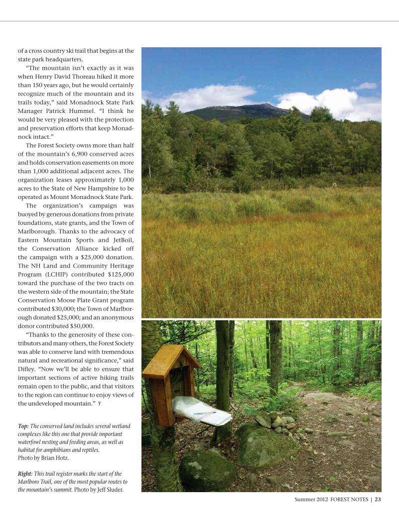
Top: The conserved land includes several wetlandcomplexes like this one that provide important waterfowl nesting and feeding areas, as well ashabitat for amphibians and reptiles. Photo by Brian Hotz.
Right: This trail register marks the start of theMarlboro Trail, one of the most popular routes tothe mountain’s summit. Photo by Jeff Sluder.
of a cross country ski trail that begins at thestate park headquarters. “The mountain isn’t exactly as it was
when Henry David Thoreau hiked it morethan 150 years ago, but he would certainlyrecognize much of the mountain and itstrails today,” said Monadnock State ParkManager Patrick Hummel. “I think hewould be very pleased with the protectionand preservation efforts that keep Monad-nock intact.”The Forest Society owns more than half
of the mountain’s 6,900 conserved acresand holds conservation easements on morethan 1,000 additional adjacent acres. Theorganization leases approximately 1,000acres to the State of New Hampshire to beoperated as Mount Monadnock State Park. The organization’s campaign was
buoyed by generous donations from privatefoundations, state grants, and the Town ofMarlborough. Thanks to the advocacy ofEastern Mountain Sports and JetBoil, the Conservation Alliance kicked off the campaign with a $25,000 donation.The NH Land and Community HeritageProgram (LCHIP) contributed $125,000 toward the purchase of the two tracts onthe western side of the mountain; the StateConservation Moose Plate Grant programcontributed $30,000; the Town of Marlbor-ough donated $25,000; and an anonymousdonor contributed $50,000. “Thanks to the generosity of these con-
tributors and many others, the Forest Societywas able to conserve land with tremendousnatural and recreational significance,” saidDifley. “Now we’ll be able to ensure that important sections of active hiking trails remain open to the public, and that visitorsto the region can continue to enjoy views ofthe undeveloped mountain.”
Summer 2012 FOREST NOTES | 23

24 | FOREST NOTES Summer 2012
DEPARTMENT NAME HERE
Just as the Forest Society, through its con-servation efforts, is re-assembling once-frag-mented lands throughout New Hampshire,the Furnald family of South Hamptonhas been expanding—and protecting—Whippoorwill Farm for more than 30 years.Most recently, Clint and Kimberly Furnaldconveyed a conservation easement on 76 acres in East Kingston and South Hamp-ton to the Forest Society.Whippoorwill Farm is a critical link in a
rare agricultural and forested oasis in NewHampshire’s southern tier. Just two milesfrom the Massachusetts border and 15miles from New Hampshire’s busy Seacoast,the farm’s open fields and forests roll acrossthe East Kingston/South Hampton townlines, connecting other conserved land. The NH Fish and Game Department’s
Wildlife Action Plan has identified much ofWhippoorwill’s Appalachian oak-pine forestas “best in state” for this quickly disappear-ing type of habitat, which is unique to theSoutheast and Upper Merrimack Valley,and the Towns of East Kingston and SouthHampton have also identified the land as aconservation priority. Whippoorwill Farm is a haven for many
species of wildlife, including bobolinks andother birds that depend upon grasslandhabitat for survival. In fact, the Furnaldsdelay mowing portions of their fields toallow resident bobolinks to finish nesting. This historic farmstead serves as a visual
link demonstrating the owners’ commit-ment to sustaining the region’s agriculturalheritage. With its 44 acres of prime andstatewide significant agricultural soils, ofwhich more than 30 acres are in active hayand forage production, the property pre-serves excellent farmland in an area of thestate that is both the most productive andthe most threatened. The fields providehay for a local dairy farm in East Kingston,fueling the local food production cycle,while the property’s forests are sustainablymanaged for fuel and fiber.In a state that produces only five percent
of the food it consumes, preserving agri-cultural production is not just commonsense, it is vital to our quality of life in aworld of expensive fossil-fueled transporta-tion and climate-threatened cropland. The Natural Resource Conservation Servicerecognizes this as do the towns of SouthHampton and East Kingston. All threepulled together to contribute much of thefunding needed to make this projectsuceed. But the key contribution was by the Furnalds themselves, who sold theeasement at a substatial discount to makethe project financially feasible.The Furnald family first purchased
Whippoorwill Farm in 1978 with the goalof preserving it and creating a legacy offamily farming. First came smaller purchases from abutting private landown-ers. Then, about six years ago, a developerpurchased a neighboring tract in SouthHampton and proposed a large-scale subdi-vision. Clint, with the indispensable aid of the Howfirma Trust, put together a
financing package to buy the developer outand instead conserve 35 acres. Anothertransaction placed 23 acres on the north-east side of the farm in East Kingston underan easement held by the town. This mostrecent transaction, financed by the NaturalResource Conservation Service, the townsof East Kingston and South Hampton, andcontributions from many individuals, addsanother 72 acres of land to the local conservation mosaic. Clint and Kimberly’soldest son is studying agriculture in collegeand plans to return to Whippoorwill Farmto continue his parent’s farming legacy. “We are proud share the forward-thinking
conservation ethic of the Furnald Family inensuring the long-term protection ofWhippoorwill Farm,” said Forest SocietyPresident/Forester Jane Difley. “We are alsograteful to the conservation commission-ers, select boards, and town administratorsof South Hampton and East Kingston, tothe NRCS, and to the many private donorswho helped make the project succeed.”
CONSERVATION SUCCESS STORIES
An Agricultural Oasis in the SeacoastBy Mike Speltz
Whippoorwill Farm contains 44 acres significant agricultural soils, the majority of which are in activehay and forage production. These fields provide hay for a local dairy farm in East Kingston, fueling thelocal food production cycle. Photo by Mike Speltz.

Summer 2012 FOREST NOTES | 25
This spring, with the assistance of theTown of Northwood, the Forest Society purchased a 77-acre conservation easementfrom Chris and Dottie Gallagher at a reduced bargain sale. More than 2,100 feet of ephemeral first-
order streams flow through this newly-con-served land en route to the Lamprey River,a major tributary of Great Bay. As a result,protection of this property contributes tothe quality of this nationally-recognizedwatershed. Together, the property’s upland forests,
basin swamps, vernal pools, headwaterstreams, as well as its hay meadow con-tribute significantly to an interesting arrayof animals and plants that includes Canadawarblers, bobolinks, and ancient black gumtrees.In New Hampshire, basin swamps
supporting black gum, such as those foundon the Gallagher’s land, are an uncommonsite. However, several excellent examplescan be found in the Town of Northwood.Black gum is a resilient tree species that cantolerate acidic, stagnant, nutrient-poorgrowing conditions and a number of envi-ronmental stressors that most other speciescannot, such as drought, fire, flood, shade,and even windthrow. As a result of its adaptations to such
environmental extremes, black gum is along-lived and slow-growing species. Infact, the oldest-known hardwood tree inNorth America is a 700-year-old black gumfrom a southeastern New Hampshireswamp! According to the New HampshireNatural Heritage Bureau, the Gallagherproperty is home to a black gum approaching30 inches in diameter and estimated to be500 years in age. Even in death, the stand-ing trunks of black gum provide excellenthabitat for mammals and birds alike. Additionally, the property abuts other
conserved lands, including NorthwoodMeadows State Park, creating a large con-tiguous block of more than 2,300 acres of
formally protected lands. These conservedproperties lie within a larger, mostly unfragmented 4,000-acre block of land.Composed of an interconnected network ofwetlands and uplands, this area supports adiverse flora and several wide-rangingwildlife species such as black bear, bobcat,fisher, northern goshawk, and moose.Importantly, it is within this larger block
that an informal group of private and publicneighbors established the Northwood AreaLand Management Collaborative (NALMC).
It is through this partnership that the Gallagher’s were introduced to the ForestSociety. “When you live on a place as long as
we have… you just fall in love with it,” said Chris Gallagher. “We’re committed to protecting it.”
A large black gum on the Gallagher property. These stalwart trees are known to live for several hundred years.
Black Gum Swamp Conserved By Chris Borg
Read more about NALMC online atwww.forestsociety.org/nalmc

CONSERVATION SUCCESS STORIES
26 | FOREST NOTES Summer 2012
If you were to hike to the top of Thomp-son Mountain in Hillsborough today, youmight notice Mount Monadnock in the distance or the cairns along the trails, thetallest at nearly eight feet marking the sum-mit. However, if you were a member of theWenny family, you would notice a differentview entirely. Through their eyes, you wouldsee the family history in the landscape, nowprotected thanks to their generous donationof 375 acres to the Forest Society.Douglas Wenny and Betsy Baker-Wenny
contacted the Forest Society last year expressing their wish to donate this formerfamily campsite to the organization. Theland extends up and over Thompson Moun-tain, containing the entire summit at 1,760feet, and includes many internal hiking trails.One trail leads to the mountain’s summit,where several overlooks offer dramatic viewsto the south and east. A well-managed regis-tered Tree Farm, the property has seen several improvement harvests over the last 10years. Going forward, this land, now knownas the Wenny-Baker Forest on ThompsonMountain, will be owned and managed bythe Forest Society. Looking backward, it
reflects the story of a family’s past. Betsy Baker-Wenny’s grandparents,
Donald and Margaret Baker, began sum-mering in Hillsborough in the 1930s. Thefarmer who owned much of the acreage onThompson Mountain, Walter Murdough,granted the couple permission to camp onhis land with their children. ThompsonMountain may be heavily wooded now, butMr. Murdough would have talked about the days when this place served largely aspasture for up to nine different types of cattle. Many of the hiking trails that existtoday began as cow paths. A labor of love created a lifestyle very dif-
ferent from the one the Wenny family livedback home in Wilmington, Dele. Withoututilities or running water at the campsite,the family of six learned to live off of theland, save for the occasional journey intotown. They cooked their meals over an openflame or on a propane stove; they sourcedtheir water from natural springs on the landthat they worked to clean out and maintain.The Wennys were fortunate to have appletrees and blueberry bushes nearby.Years later, Donald and Margaret’s
daughter Betsy and her husband Douglashonored Betsy’s family heritage by pur-chasing Walter Murdough’s land with thehelp of Betsy’s family. Although all theWenny children are now grown and livingacross the country, conserving this piece oftheir past was important to all of them, aswell as the town. Conserving this land was important to
others, too, including the HillsboroughConservation Commission, which provideda grant of $17,000 to help cover some of thetransaction costs related to the project.Abutting Lowe State Forest, the land is alsoa priority of the Quabbin-to-Cardigan(Q2C) conservation initiative. At 375 acres, this woodlot is the second
largest Forest Society reservation in Hills-borough. “It’s truly inspiring to see largeland gifts still coming in,” said Hotz. “It’salso encouraging to see the HillsboroughConservation Commission supportingthese conservation-minded donors byhelping to cover project costs.”At last, the land that was the source of so
many memories will now be protected inperpetuity.
Mountaintop Legacy ConservedBy Lori Johnson
Left: The recently-conserved land extends up and over the summit of Thompson Mountain, and offers dramatic overlooks to the south and east. Photo by Brian Hotz.
Right: A network of internal hiking trails crosses the land, many marked by cairns. This cairn at the summit is over eight feet high. Photo by Brian Hotz.

Summer 2012 FOREST NOTES | 27
A New Hampton Haven for Songbirds By Chris Borg
Above: Birds like this chestnut-sided warbler seen on the conservedland are not only great indicators of habitat condition, but also con-duits for connecting people with place. Photo by Len Medlock.
Right: Hoyt Brook is one of the perennial streams that flows through theconserved land, draining into the lower Pemigewasset River watershed.Photo by Chris Borg.
“Pleased, pleased, pleased… to meet cha,”the sweet song of a male chestnut-sidedwarbler greeted me as I approached the lateeighteenth century farmhouse of LouisCandito. This neotropical songbird, withits distinct yellow crown, black whiskerstripe, and extensive chestnut flanks, isanything but resident to these woods. Hemerely borrows them from time to time.“You must be Chris… Nice to meet you,”
Lou said, emerging from his farmhouse. “I’vebeen trying to see that bird all morning.”This past winter, the Louis Candito Trust
donated a conservation easement to theForest Society on 174 acres in the Town ofNew Hampton. Situated at the headwatersof perennial Hoyt and Harper Brooks, thislargely forested, mostly upland tract lieswithin the lower Pemigewasset River watershed, and its protection contributesto local water quality. In fact, more than4,300 feet of first and second order streamsflow through the conserved land.
Additionally, at least two vernal poolsoccur on the property and provide breed-ing habitat for wood frogs and Americantoads. The land’s forests include pure conif-erous stands of eastern hemlock as well ashardwoods dominated by American beech.Embedded within these uplands is a two-acreherbaceous drainage marsh community. Theland also contains about seven acres of fieldsmaintained for scenic westward mountainviews as well as for wildlife—like the visitingchestnut-sided warbler. In concert, the property’s wetlands,
fields, and forested habitats contribute significantly to a diverse flora and faunathat includes wetland plants like turtleheadas well as amphibians such as the terrestrialnorthern redback salamander. The landalso offers safe harbor to many charismaticwildlife species, such as barred owl, blackbear, and even the occasional moose. Importantly, this newly-protected land
is situated within a large unfragmented
forest block designated as a conservationpriority in New Hampton’s 2002 MasterPlan and also in the Forest Society’s Lake’sRegion Strategic Plan. “Fire fire…where where… here here.” An
indigo bunting perched high in a sugar maplerevealed himself while proclaiming territory. Throughout the day, I explored the
property with Mr. Candito, taking notes,measurements, and photographs. But allthe while, I kept my eyes and ears focusedbeyond and pointed out the more obviousand charismatic birds to Lou. A male scarlettanager tee’d on a high snag overlookingthe property’s wetland provided excep-tionally nice looks. By the end of thiswarm, late July day, we had recorded over30 bird species! Birds are not only great indicators of a
property’s habitat condition, but likewiseexcellent conduits for connecting peoplewith place… the perfect formula for inspiringland conservation.

28 | FOREST NOTES Summer 2012
CONSERVATION SUCCESS STORIES
Befriending a Fen in FremontBy Mike Speltz
The citizens of Fremont believe thatthey are the stewards of one of the mostvaluable aquatic resource in southern NewHampshire: the community’s 824-acreSpruce Swamp. Despite its popular name, Spruce Swamp
is really a “fen,” a wetland fed by groundwater with only a minimal flow leaving thewater body. The shallow bowl now filled by Spruce Swamp was created by the lastglacier. Decaying wetland plants, waterleached through the organic duff of surrounding forests, and a lack of watermovement made the fen moderately acidic.This big, burly swamp is as dependent uponthe health of the surrounding uplands as anestling is upon the steady visits of food-bearing adult birds. Without the adjacentforest land to provide and protect a reliableflow of clean, acidified ground water, theswamp will die—or at least become a muchmore common meadow.
On April 2, the town added anotherpiece of armor to the forested buffer pro-tecting the swamp. This latest addition of76 acres was purchased from brothersRichard and Robert Smith, with the goal ofadding it to the Glen Oakes Town Forest,purchased in 2006. The Forest Society assisted in the establishment of the townforest, holds an easement on it, and hasnow been granted an easement on this latest76-acre addition. This unique habitat shelters many
shrubs at the extreme northern limit oftheir range, including sweet pepperbush,which dominates a remarkable 200-acresub-community that is one step from beingimperiled in New Hampshire. The propertyis home to the state-endangered ringed boghaunter, also uncommon globally, andloon and great blue heron have been spot-ted nearby. The state-threatened spottedturtle and state-endangered Blandings turtlehave also been found near the property. Altogether biologists have identified 104animal and 152 plant species on the
Spruce Swamp is really a “fen,” a wetland fed by ground water with only a minimal flow leaving the waterbody. Without the adjacent forest land to provide and protect a reliable flow of clean, acidified groundwater, the fen will die. Photo by Mike Speltz.
• Robert and Richard Smith: Who inherited this land from their grandfather and turneddown offers from developers in order to preserve it.
• Janice O’Brien: Conservation commissioner who led the project over seven years.
• Dennis Howland: Open space committee chair who showed the community why conservation pays.
• Bill Knee: Biologist and teacher who told the Spruce Swamp story.
• Jack Karcz: Conservation commission chair who shepherded the project to conservation success.
• Heidi Carlson: Fremont town administrator who guided the project to closing.
• Pat deBeer: Who brought in a handful of grants to finance the project.
• The following grantors who showed their confidence in the Town of Fremont:
The State Conservation Committee’s 2012 Conservation License Plate Program(Moose Plate)
The William P. Wharton Trust
The Davis Conservation Foundation
The Cricket Foundation
Fields Pond Foundation
• The Board of Fremont Selectmen, who stood up to be counted when it mattered most.
FRIENDS OF THE FEN
adjacent town forest, many of which willlikely be found on the abutting new addition. The town has sought to conserve Spruce
Swamp for human habitat as well, to provideopportunities for people to re-connect withthe land. Today, two and a half miles of
newly constructed or improved trails aresupported by maps and signs at each inter-section, linking walkers to old cellar holes,diverse natural communities, animal pensand stone walls that testify to previousfarms, and plain peace and quiet.

Summer 2012 FOREST NOTES | 29
The Newfound Lake region is one ofNH’s hidden gems. Surrounded bysteep forested hillsides, this pictur-
esque lake is one of the cleanest in the state.These forests are home to five summeryouth camps, one of which has been oper-ating for nearly a century. These camps alsokeep hundreds of acres and miles of shore-line undeveloped. Fortunately, even with the development
pressures of the late 20th century, the essential character and quality of the New-found Lake region remains intact. Andtoday, summer people, year-round residents,and visitors are realizing that to keep it that way will require working together toconserve what's special.Newfound Lake is considered a “Class A”
lake due to its pristine water quality andlargely undeveloped watershed. In 2007the Newfound Lake Region Association realized that proactive steps were needed to protect the integrity of the watershedand prevent the degradation experiencedaround other more developed lakes.At the same time, the NH Fish and Game
Department’s Wildlife Action Plan revealedthat much of the Newfound Lake water-shed was characterized by some of thehighest quality wildlife habitat in the state.Prior to this, the Forest Society’s Quabbin-
to-Cardigan Initiative also identified theNewfound watershed as a high priority forconservation due to its large, seamlessforested landscapes and important waterresources. Recognizing that effective land conser-
vation by private landowners is essential topreserving the integrity of the watershed,the Newfound Lake Region Association, the Forest Society and the Lakes RegionConservation Trust formed the Newfound
Land Conservation Partnership (NCLP).Bolstered by a grant from the NH CharitableFoundation, the Partnership has been active since 2009, sponsoring workshopsand sharing information with landownersand towns about the conservation optionsavailable to protect the conservation valueson privately-owned land. These values include retaining the water quality ofstreams, rivers, and the lake; protectingwildlife habitat or rare species; conservingworking farmland; sustainably managingthe area’s forests for wood products; and fostering opportunities for public recreation.Building relationships with landowners,
the group brings projects forward andrefers them to the appropriate land trust,most often the Forest Society, or Lakes Region Conservation Trust. One of thegroup’s first conservation successes involvedthe donation in 2011 by an abutter to CampPasquaney of a 120-acre parcel to the camp,with a conservation easement on it held by
the Forest Society. Today the Partnership is working to conserve several parcelsthroughout the watershed—including theHazelton Farm profiled on page 32. In late summer of 2011, Forest Society
member Helen Gemmill, daughter of the late Camp Pasquaney Director JohnGemmill, established a charitable fund inhonor of her father to support land conser-vation in the Newfound Lake watershed,where she too spent her childhood exploring.This remarkable $750,000 gift, in Helen’swords, “will inspire us all …to see the truetreasure in Newfound Lake and the sur-rounding hills and streams, and take actionupon our belief in those treasures.” Today, this creative collaboration will
help ensure that the future quality of the Newfound Lake and its watershed arepreserved. The potential for protecting thisspecial place is much greater, thanks to theNLCP and the individuals and organiza-tions that created it.
The Land, the Lake and the People Who Love ThemA Newfound Lake success storyBy Martha Twombly and Paul Doscher
Surrounded by steep forested hillsides, picturesque Newfound Lake is one of the cleanest lakes in the world.Photo by Brian Hotz.
HEARD ON THE TRAIL

30 | FOREST NOTES Summer 2012
Legend has it that Lyman and RoyalJackman accidentally discovered the“Shadow Cave” in what is now the
Forest Society’s oldest forest reservation, LostRiver. The two young men had been fishingtheir way up toward remote beaver ponds in Kinsman Notch in 1852 when Lyman suddenly disappeared. He had slippedthrough a moss-covered hole and fallen 15 feet into a waist-deep pool. Royal Jackmaneventually blazed a four-mile trail to guideintrepid tourists back to the cave, where heexplained, “This is where my brother foundthe lost river.” The name stuck.A jumble of boulders alternately cradles
and conceals Lost River at the foot of a talusslope beneath the Dilly Cliffs. Twelve thou-sand years before the Jackman brothers, themile-thick sheet of ice covering the WhiteMountains began to recede. Roaring torrentsof glacial melt-water plunged down thesheer faces of ice cliffs twice the height ofcontemporary Cannon Cliff, the westernwall of Franconia Notch. Boulder caves atLost River were shaped and scoured by the raging waters, which exposed a resist-ant pegmatite dike. Melt-water carved immense arching potholes into the granitebedrock. By the 1870s, intrepid touristsmarveled in “dusky chambers” at the“grandeur, desolation and wild loveliness”of Lost River’s wild mountain scenery.Forests eventually colonized the jumble
of boulders. It isn’t easy growing in harsh,subalpine conditions where winds rou-tinely accelerate through the narrow cleftof Kinsman Notch to create the legendaryroar known as the “Bunga Jar,” named forits local place of origin near Bungy. Soil isthin to non-existent. The boreal trees bestadapted to this micro-climate are redspruce, balsam fir, white birch, and yellowbirch. Where soil is deeper and disturbance
less frequent, beech and sugar maple—classic transitional northern hardwood forest—can be found. The oldest trees stillstanding today are spruce and yellow birch.
White birch pioneers, a legacy of the lum-bering activity and fires that took place atthe turn of the century throughout theWhite Mountains, are now dying of old age
Legend has it that Lyman Jackman accidentally discovered the Shadow Cave after slipping through amoss-covered hole to fall 15 feet into a waist-deep pool. Photo by Jerry and Marcy Monkman, EcoPhotography.
Lost River: A Gift of the GlaciersThe gift of the glacier was a rugged bequest: A landscape too wild, rocky, broken, and steep for even the craftiest of loggers.By Dave Anderson
NATURE’S VIEW

Summer 2012 FOREST NOTES | 31
as they approach the century mark.Before the close of the 19th century,
logging interests advanced high into the remote, rugged terrain of Kinsman Notchto access virgin spruce timber. Logging onMount Moosilaukee along the upper WildAmmonoosuc River featured a series ofsmall impoundments called “squirt dams”to build a sufficient head of water to flushlogs west downstream toward mills atWoodsville and points further south on theConnecticut River. East of Lost River, the now-forgotten
Gordon Pond logging railroad served alarge sawmill operated from 1904 to 1916 bythe G.L. Johnson Lumber Company inWoodstock. The underlying land itself wasowned by the Publisher’s Paper Company,which had conveyed the timber rights tothe infamous logger G. L. Johnson. In turn,Johnson drove a shrewd bargain with theMatson Manufacturing Company of Penn-sylvania, selling them the rights to the relatively worthless yellow birch in KinsmanNotch while retaining the rights to morevaluable red spruce timber. In that era,hardwood timber—used for making specialty products, furniture, and bobbins
and spools for the textile industry—wasconsidered much less valuable than the high-volume softwood timber used for lumber. Johnson has been described as “a shrewd
old cuss… so crooked he could hide behinda cork screw.” Johnson’s woods crew walk-ing boss, Jake McGraw, was charged withfiguring out how to extract the virginspruce timber off the steep walls of KinsmanNotch. Jakey McGraw’s operation utilized a“Steam Donkey” engine rigged to a loggingcable to help lower logs and even horseteams to the floor of Kinsman Notch. Today,the rusting remains of a 100-year old steamengine remain hidden on a spruce-cladknoll south of the Lost River Reservation. The Forest Society finally succeeded in
protecting the 152-acres that make up LostRiver in March of 1912. The land itself was donated by Publisher’s Paper Com-pany, and Mattson Manufacturing donated the hardwood timber rights. However, the Forest Society still needed to purchase thesoftwood timber rights owned by G.L.Johnson. Living up to his reputation, Johnsondrove another hard bargain, negotiatingthe sale of the softwood timber rights to theForest Society for $7,000. Today the tract
harbors still small fragments of old yellowbirch and red spruce—trees that G.L. John-son and Jake McGraw calculated could not be extracted from the rugged and inop-erable Lost River landscape.Years later, Forest Society Assistant
Forester J. Wilcox Brown wrote The ForestHistory of Mount Moosilaukee. Brown includesan anecdote from 1916 when Johnson returned to Lost River at the height of thesummer season to witness tourists paying25 cents each to tour the Lost River Gorge.Johnson is alleged to have said, “Dammit, I never should have sold this place, and I couldn’t see it.” Brown chuckled whentelling the tale of a shrewd logger, addingthat “Johnson lived to regret but one busi-ness mistake” when he drove such a hardbargain with the Forest Society for its acquisition of Lost River.The glacier’s rugged bequest to all of us
is this incredibly rugged and beautiful land-scape—too rocky, wild, and steep for eventhe craftiest of White Mountain loggers.
Naturalist Dave Anderson is director of educa-tion and volunteer services for the Protection ofNew Hampshire Forests.
Left: Part of Kinsman Notch, the Dilly Cliffs, shown here, were formed by glaciers twelve thousand years ago. Eager to harvest all the valuable virgin spruce timber off these steep walls, the notorious G.L. Johnson Lumber Company developed a system to lower logs and even horse teams from the steep cliffs down to the floor of Kinsman Notch. Photo by Jerry and Marcy Monkman, EcoPhotography.
Right: The oldest trees still standing at Lost River today are spruce and yellow birch, including the ancient tree shown here. Photo by Dave Anderson.
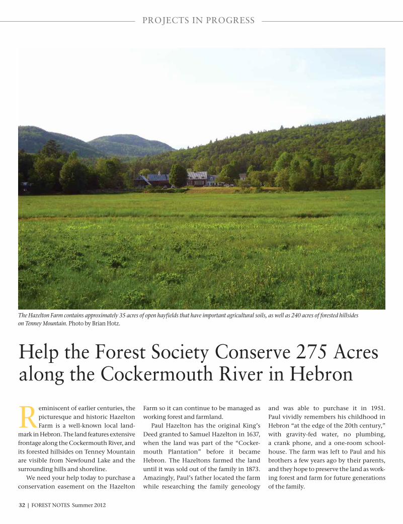
Help the Forest Society Conserve 275 Acresalong the Cockermouth River in Hebron
Reminiscent of earlier centuries, thepicturesque and historic HazeltonFarm is a well-known local land-
mark in Hebron. The land features extensivefrontage along the Cockermouth River, andits forested hillsides on Tenney Mountainare visible from Newfound Lake and thesurrounding hills and shoreline. We need your help today to purchase a
conservation easement on the Hazelton
Farm so it can continue to be managed asworking forest and farmland. Paul Hazelton has the original King’s
Deed granted to Samuel Hazelton in 1637,when the land was part of the “Cocker-mouth Plantation” before it became Hebron. The Hazeltons farmed the landuntil it was sold out of the family in 1873.Amazingly, Paul’s father located the farmwhile researching the family geneology
and was able to purchase it in 1951. Paul vividly remembers his childhood inHebron “at the edge of the 20th century,”with gravity-fed water, no plumbing, a crank phone, and a one-room school-house. The farm was left to Paul and hisbrothers a few years ago by their parents,and they hope to preserve the land as work-ing forest and farm for future generationsof the family.
The Hazelton Farm contains approximately 35 acres of open hayfields that have important agricultural soils, as well as 240 acres of forested hillsides on Tenney Mountain. Photo by Brian Hotz.
PROJECTS IN PROGRESS
32 | FOREST NOTES Summer 2012

Why is this land so special?Water quality protection—Located near
the north end of Newfound Lake, one ofthe state’s most pristine water bodies, theland overlays a stratified drift aquifer thatdrains into the lake. The property also includes two-thirds of a mile of frontagealong the Cockermouth River and a half-mile of frontage along Wise Brook. Fisheries—Both Wise Brook and the
Cockermouth River are important spawningareas for native brook trout and land-lockedsalmon. Wildlife habitat—The NH Department
of Fish and Game’s Wildlife Action Plan indicates that the Hazelton land containsthe highest quality wildlife habitat becauseof its continuous forestlands and brooks.This land is also close to other conservedlands, including the Hebron Town Forest,Audubon Fields, and Cockermouth Forest.Recreation—The Hazelton family has
created ski and walking trails and welcomesthe public to enjoy their land on hikes toBald Knob, Crosby Mountain, and TenneyMountain. A popular snowmobile trailfollows Tenney Lane to the network of trailsconnecting to the entire Lakes Region.
Regional and local impor-tance—This land is located in apriority focus area of the Quab-bin-to-Cardigan ConservationInitiative, the Lakes RegionConservation Plan, the HebronConservation Commission,and the Newfound Lake RegionAssociation. Working farm and forests—
The land contains approxi-mately 35 acres of openhayfields that have importantagricultural soils. The forestedportion, a registered Tree Farm,is being sustainably managedfor wood products and wildlifehabitat under the guidance of aprofessional forester. The Hazelton family wishes to sell a
conservation easement to the Forest Society.We need to raise $298,000 in order to payfor the conservation easement, projectscosts, and stewardship expenses associatedwith this project. If we are successful, the conservation easement will guaranteecontinued public access for recreation.
Please help the Forest Society protect thewater quality of the Cockermouth Riverand Newfound Lake by making your dona-tion today.
Join us for a field trip on July 21 at theHazelton Farm. Watch the website for
details and registration.
YES, I WANT TO HELP THE FOREST SOCIETY CONSERVE HAZELTON FARM
Name:
Address:
Town/City: State: Zip:
Telephone: Email:
Enclosed is my tax-deductible contribution for $_________________(Please make check out to the Forest Society, with “Hazelton Farm” on the memo line.)
VISA MasterCard Number: ____________________________ Expiration date: ______ Security code: ______
Please mail the completed form to: Hazelton Farm, Society for the Protection of New Hampshire Forests54 Portsmouth Street, Concord, NH 03301. Or donate online at www.forestsociety.org/Hazelton.
For more information, contact Susanne Kibler-Hacker at 603-224-9945 or via e-mail at [email protected].
HAL126FN 4104 T182
Thank you for your help!
275 acres in Hebron

NonprofitOrganization
US Postage PaidManchester, NHPermit No. 0494
SOCIETY FOR THE PROTECTION OF NEW HAMPSHIRE FORESTS54 Portsmouth StreetConcord, NH 03301-5400Address Service Requested
SATURDAY, SEPTEMBER 15, 2012
CATALYSTS FOR CHANGE
EARLY BIRD DEADLINE:TUESDAY, AUGUST 15TH!
TO REGISTER:Sign up online at
www.forestsociety.org OR
Call Tina at (603) 224-9945 ext. 313
Sponsored by
Goffstown, N.H.
McLane, Graf,
Raulerson & Middleton
AnnualMeeting
ONE HUNDRED E L EVENTH
THE FOREST SOCIETY’S
HIGHLIGHTS:10:00 am FIELD TRIPS AND WORKSHOPSto 3:00 pm • Farm and Forest History at Mount Monadnock
• Hurricane Hill Hike• Exploring Goose Pond• Tour High Blue Forest Reservation• Forestry and Forest Health• Pitcher Mountain Hike• Afternoon Tour at Stonewall Farm
4:00 pm FOREST SOCIETY ANNUAL BUSINESS MEETINGto 8:00 pm • Reception and Recognitions (including cash bar)
• Business Meeting•Dinner• Awards and Keynote Address: Phil Bryce, Director of the NH Division of Parks and Recreation• Adjourn
COST: Early Bird price is $40 per person prior to August 15th. Regular price is $50 per person.Final registration deadline is September 7.
Pre-registration is required. There will be no on-site registration. Please register early as spaceis limited. For more information and to register, please visit www.forestsociety.org or call Susan Faretra at (603) 224-9945 ext. 345.
See page 17 for field trip options!
Celebrate land conservation in the Monadnock Region at the Forest Society’s 111th Annual Meeting. Photo by Jerry and Marcy Monkman, EcoPhotography.
Join us in the heartof the MonadnockRegion at StonewallFarm in Keene.