100 mile house timber supply area - british columbia
TRANSCRIPT
Forest Stewardship Plan
100 Mile House Timber Supply Area
BC Timber Sales Kamloops Business Area
2
TABLE OF CONTENTS
1 ADMINISTRATION AND INTERPRETATIONS .............................................................................................. 7 1.1 Definitions in this FSP ........................................................................................................................ 7 1.2 Definitions under Enactment .......................................................................................................... 12
2 SUBMISSION, TERM AND EFFECTIVE DATE OF THIS FSP ........................................................................ 12 2.1 Submission ....................................................................................................................................... 12 2.2 Effective Date .................................................................................................................................. 12
3 APPLICATION OF THIS FSP ...................................................................................................................... 12 3.1 CONTENT OF THIS FSP ..................................................................................................................... 12 3.2 ASSOCIATED STATUTES ................................................................................................................... 13
4 FOREST DEVELOPMENT UNITS ............................................................................................................... 14 4.1 FDUs Identified in the FSP ............................................................................................................... 14 4.2 Items Identified in the FDUs ............................................................................................................ 15
5 100 MILE HOUSE TSA RESULTS OR STRATEGIES ..................................................................................... 18 5.1 Soils .................................................................................................................................................. 18 5.2 Biodiversity – Landscape Level ........................................................................................................ 18
5.2.1 Spatial / Temporal Distribution of Cutblocks and Species Composition................................................. 18 5.2.2 Landscape Unit (LU) Boundaries ............................................................................................................. 21 5.2.3 Old Seral Landscape Biodiversity ............................................................................................................ 21 5.2.4 Mature + Old Seral Landscape Biodiversity ............................................................................................ 23
5.3 Biodiversity – Stand Level ................................................................................................................ 26 5.3.1 Wildlife Tree Retention ........................................................................................................................... 26 5.3.2 Riparian Areas ......................................................................................................................................... 29
5.4 Water ............................................................................................................................................... 33 5.4.1 Water in Community Watersheds .......................................................................................................... 33 5.4.2 Hydrology ................................................................................................................................................ 35 5.4.3 Fisheries Sensitive Watershed ................................................................................................................ 37
5.4.3.1 Horsefly River Fisheries Sensitive Watershed (GAR F-5-001) ................................................ 41
5.4.3.2 Fisheries Sensitive Watershed - Deadman Watersheds (GAR F-3-013) ................................ 44
5.5 Wildlife ............................................................................................................................................ 45 5.5.1.1 Species at Risk – General ...................................................................................................... 45
5.5.1.2 Species at Risk Listed under Government Action Regulation (GAR) .................................... 48
5.5.1.3 Mountain Caribou – Eastern Herds ...................................................................................... 48
5.5.1.4 American Badger and Spadefoot Toad ................................................................................. 49
5.5.1.5 Great Blue Heron .................................................................................................................. 50
5.5.2 Species at Risk Not Listed under GAR ..................................................................................................... 51 5.5.2.1 Grizzly Bear ........................................................................................................................... 51
5.5.2.2 Bighorn Sheep....................................................................................................................... 53
5.5.2.3 White Pelicans ...................................................................................................................... 53
5.5.2.4 Bull Trout (Dolly Varden) ...................................................................................................... 54
5.5.2.5 Sandhill Crane ....................................................................................................................... 55
Forest Stewardship Plan
100 Mile House Timber Supply Area
BC Timber Sales Kamloops Business Area
3
5.5.2.6 Prairie Falcon ........................................................................................................................ 55
5.5.2.7 Furbearers – Fisher ............................................................................................................... 56
5.5.2.8 Furbearers – Wolverine ........................................................................................................ 57
5.5.2.9 Furbearers – General ............................................................................................................ 58
5.5.3 Other Species at Risk & Sensitive Habitats ............................................................................................. 59 5.5.3.1 Critical Fish Habitat ............................................................................................................... 59
5.5.3.2 Grasslands............................................................................................................................. 60
5.5.4 Wildlife – Regionally Important Species ................................................................................................. 60 5.5.4.1 Moose ................................................................................................................................... 60
5.5.4.2 Mule Deer ............................................................................................................................. 63
5.5.4.3 Salmon .................................................................................................................................. 64
5.5.5 Access Management for Wildlife ............................................................................................................ 64 5.6 Cultural Heritage Resources ............................................................................................................ 65 5.7 Recreation and Backcountry ........................................................................................................... 67
5.7.1 Backcountry ............................................................................................................................................ 67 5.7.2 Wildcraft ................................................................................................................................................. 68 5.7.3 Recreation Sites, Trails and Interpretive Forests .................................................................................... 69 5.7.4 Buffered Trails ......................................................................................................................................... 70
5.8 Visual Quality ................................................................................................................................... 71 5.9 Tourism ............................................................................................................................................ 74
5.9.1 Tourism – General................................................................................................................................... 74 5.9.2 Lakeshore Management Zoness ............................................................................................................. 75
5.10 Range and Grazing ........................................................................................................................... 78 5.10.1 Natural Range Barriers ............................................................................................................................ 78 5.10.2 Animal Unit Months ................................................................................................................................ 79
5.11 Invasive Plants ................................................................................................................................. 80
6 Stocking Standards ................................................................................................................................. 82 6.1 General Discussion .......................................................................................................................... 82 6.2 Minimum Inter-Tree Distance (MITD) ............................................................................................. 82 6.3 Uneven-aged Stocking Standards .................................................................................................... 83 6.4 Regeneration Delay ......................................................................................................................... 83 6.5 Damage Criteria ............................................................................................................................... 83 6.6 Crop vs. Competition Ratio .............................................................................................................. 83 6.7 Maximum Density ........................................................................................................................... 83 6.8 Broadleaf Species and Mixed Stands ............................................................................................... 83
7 Appendices ........................................................................................................................................... 106 7.1 Appendix A – Stocking Standards .................................................................................................. 106
7.1.1 General Standards ................................................................................................................................ 106 7.1.1.1 Crop Tree Assessment ........................................................................................................ 106
7.1.1.2 Site Identification for the Purpose of Determining Stocking Standard .............................. 106
7.1.1.3 District Policies that May Apply .......................................................................................... 106
7.1.1.4 Deviation from Potential Survey Methodology to Assess Stocking Levels ......................... 106
7.1.1.5 Intermediate Harvest ......................................................................................................... 107
7.1.1.6 Uneven Aged Management ................................................................................................ 107

Forest Stewardship Plan
100 Mile House Timber Supply Area
BC Timber Sales Kamloops Business Area
4
7.1.1.7 Conversion of Multi-Story Douglas-Fir Stand to Even Aged Management Following a Wildfire 108
7.1.1.8 Mixed Wood Stocking Standards........................................................................................ 108
7.1.1.9 Broadleaf Stocking Standards ............................................................................................. 108
7.1.1.10 Brush Competition .......................................................................................................... 109
7.1.1.11 Lodgepole Pine Dwarf Mistletoe .................................................................................... 109
7.1.1.12 Retained Mistletoe Infected Lodgepole Pine to Address a Result or Strategy .............. 110
7.1.1.13 Limitations on the Use of Larch ...................................................................................... 110
7.1.1.14 Limitations on the Use of White Pine ............................................................................. 110
7.1.1.15 Enhanced Stocking Standards......................................................................................... 110
7.1.1.16 Maximum Density Limits at Free Growing ..................................................................... 110
7.1.2 Variations from General Standards ...................................................................................................... 110 7.1.2.1 Multiple Years to Harvest a SU ........................................................................................... 111
7.1.2.2 Seven Year Regeneration Delay.......................................................................................... 111
7.1.2.3 Changes to Milestones Due to Damage Caused by Wildfire .............................................. 111
7.1.2.4 Pine as a Preferred Species in IDF Subzones ...................................................................... 111
7.1.2.5 Spruce as a Preferred Species in IDF Subzones .................................................................. 111
7.1.2.6 Reduced MITD .................................................................................................................... 111
7.1.2.7 Grizzly Bear Habitat ............................................................................................................ 112
7.1.2.8 GAR Consistency ................................................................................................................. 112
7.1.2.9 Benchmark Grassland Standards ........................................................................................ 112
7.1.2.10 Bighorn Sheep Management Area Standards ................................................................ 112
7.1.2.11 Standard for the Reduction of Weevil Damage .............................................................. 112
7.1.2.12 Variations to Preferred or Acceptable Species ............................................................... 112
7.1.2.13 BEC Site Series Mosaics .................................................................................................. 113
7.1.2.14 Douglas-fir Preferred on Mule Deer Winter Ranges ...................................................... 113
7.1.2.15 Management of Root Disease Sites ................................................................................ 113
7.1.2.16 Extension to Regeneration Delay Period Required to Reduce Pressure on Seed Supply and Nursery Capacity as a Result of 2017 Wildfires ........................................................................... 113
7.1.2.17 Extension to Regeneration Delay Period When Standards Units with a 4 Year Regen Delay are a Minor Component of the Cut Block................................................................................. 114
7.1.2.18 Intermediate Harvest Stands .......................................................................................... 114
7.1.2.19 Uneven Aged Management Required to Achieve a Result or Strategy in the FSP ......... 114
7.2 Appendix B – FSP Maps ................................................................................................................. 116 7.3 Appendix C – Wildlife Tree Retention Targets .............................................................................. 117 7.4 Appendix D – Objectives for Recreation Sites, Trails and Interpretive Forest Sites ...................... 127 7.5 Appendix E – Reportable Invasive Plants ...................................................................................... 150
Forest Stewardship Plan
100 Mile House Timber Supply Area
BC Timber Sales Kamloops Business Area
5
LIST OF TABLES Table 1 FDUs for the BCTS 100 Mile House TSA FSP ........................................................................................ 14 Table 2 - Road Permits in Effect on the Submission Date ................................................................................ 16 Table 3 - Declared Areas ................................................................................................................................... 16 Table 4 – Patch size target ranges ................................................................................................................... 19 Table 5 – Natural Connectivity Characteristics Frequency ............................................................................... 20 Table 6 – Mature plus Old Seral stage age definitions and targets .................................................................. 25 Table 7 – Minimum mature plus Old Seral target drawdowns ....................................................................... 25 Table 8 - Wildlife Tree Classes .......................................................................................................................... 26 Table 9 - Riparian Retention Requirements ..................................................................................................... 31 Table 10 - Maximum Equivalent Clearcut Areas (ECA) for the Kamloops TSA Watershed, Basins and Sub-basins ................................................................................................................................................................ 45 Table 11 - Wildlife Species at Risk and Type of Reportable Occurrence .......................................................... 46 Table 12 - Plant Species at Risk and Reportable Type of Occurrence .............................................................. 47 Table 13 - Plant Communities at Risk ............................................................................................................... 47 Table 14 - Lakeshore Management Classes (CCLUP LUO Schedule 2) ............................................................. 77 Table 15 - Authorized Level of AUM’s by FDU (CCLUP 90-Day Report) ........................................................... 80 Table 16 - Single Layer Stocking Standards ...................................................................................................... 84 Table 17 - Multi - Layer Stocking Standards ..................................................................................................... 96 Table 18 - Conversion Table for Conifer Standards to Mixed Wood Standards............................................. 108 Table 19 - Conversion Table for Conifer Standards to Broadleaf Standards .................................................. 109 Table 20 - Stocking Standards Conversion Table ............................................................................................ 115 Table 21 - Summary of FSP Maps ................................................................................................................... 116 Table 22 - Wildlife Tree Retention Targets ..................................................................................................... 117
LIST OF FIGURES Figure 1 - FDUs for the BCTS 100 Mile House TSA ........................................................................................... 15

Forest Stewardship Plan
100 Mile House Timber Supply Area
BC Timber Sales Kamloops Business Area
6
LIST OF ACRONYMS • AUM – Animal Unit Month
• BCTS – BC Timber Sales • BEC – Biogeoclimatic Ecosystem Classification • BG – Bunchgrass Biogeoclimatic Zone • BMU – Beetle Management Unit • CCLUP – Cariboo-Chilcotin Land Use Plan
• CCLUP LUO – Cariboo-Chilcotin Land Use Plan Land Use Order
• CHR – Cultural Heritage Resource • DBH – Diameter at Breast Height
• DFP – Deviation from Potential • ECA – Equivalent Clearcut Area • ESSF Engelmann Spruce Subalpine Fir Biogeoclimatic Zone • FDU – Forest Development Unit • FG – Free Growing • FPC – Forest Practices Code
• FPPR – Forest Planning and Practices Regulation • FRPA – Forest and Range Practices Act • FSP – Forest Stewardship Plan • FSR – Forest Service Road • GAR – Government Actions Regulation • ICH – Interior Cedar Hemlock Biogeoclimatic Zone • IDF – Interior Douglas-fir Biogeoclimatic Zone • IWMS – Identified Wildlife Management Strategy • LMZ – Lakeshore Management Zone
• LU – Landscape Unit
• FLNRORD – Ministry of Forests, Lands, Natural Resource Operations and Rural Development
• MITD – Minimum Inter-Tree Distance • MS – Montane Spruce Biogeoclimatic Zone • NAR – Net Area to be Reforested
• NDT – Natural Disturbance Type • NSR – Not Satisfactorily Restocked
• OGMA – Old Growth Management Area • PP – Ponderosa Pine Biogeoclimatic Zone • QRP – Qualified Registered Professional • RMZ – Riparian Management Zone
• ROS – Recreation Opportunity Spectrum • RRZ – Riparian Reserve Zone • SBPS – Sub-Boreal Pine/Spruce Biogeoclimatic Zone • SBS – Sub-Boreal Spruce Biogeoclimatic Zone • SU – Standard Unit
• TSA – Timber Supply Area • TSL – Timber Sale Licence • TSM – Timber Sales Manager • UWR – Ungulate Winter Range • VQO – Visual Quality Objective • WHA – Wildlife Habitat Areas • WTRA – Wildlife Tree Retention Area

Forest Stewardship Plan
100 Mile House Timber Supply Area
BC Timber Sales Kamloops Business Area
7
1 ADMINISTRATION AND INTERPRETATIONS
1.1 DEFINITIONS IN THIS FSP
“Access Control” means a barrier located on a road which makes the road beyond the access control point impassable with a motor vehicle as defined under the Motor Vehicle Act. Types of access control include, but are not limited to, gates, cement blocks, deep trenches, ripping the road surface for greater than 200 meters where practicable, or the piling of debris on the road.
“Adjacent” means an area that is sufficiently close to a cutblock that, due to its location, could directly impact on, or be impacted by, a forest practice carried out within the cutblock;
“Backcountry” is defined as a combination of the following Recreation Opportunity Spectrum (ROS) experiences: Semi-Primitive Motorized, Semi-Primitive Non-Motorized, and Primitive. The actual proportion of each ROS category will be subject to the targets for other resources1;
“Beetle management unit or BMU” means a management area, within which a landscape level beetle management strategy, as defined by Forests, Lands, Natural Resource Operations (FLNRORD), is implemented.
“Careful sanitation harvest practices” means harvesting with the following requirements:
• Mark to cut or mark to leave to identify infested trees planned for harvest and / or retention.
• A detailed ground-based survey must be completed before harvesting.
• To the extent practicable, skid trails must be ≤5 meters (m) wide and use existing trails where they are present.
• No new landings can be constructed within an Old Growth Management Area (OGMA). Roads can only be constructed within an OGMA where no other practicable option exists.
• Within OGMAs, old attack (grey or red non-infested trees) must be left on site when they are required to be felled due to safety concerns.
• Excluding roads, trails and landings, limit the harvest or damage of non-infested trees to 10% of the total volume of currently infested stems to be removed.
• All harvesting and removal must be completed before April 1st.
• Stumps must be 30 centimeters (cm) or lower on the uphill side.
• All large fresh debris (≥2m long and ≥20 cm in diameter) that could attract or harbour bark beetles must be removed, de-barked or burned, before April 1st.
“CCLUP” means the Cariboo-Chilcotin Land Use Plan as defined in the January 1996 declaration of the CCLUP as a Higher-Level Plan under the FPC;
“CCLUP LUO” means the Cariboo-Chilcotin Land Use Plan Land Use Order approved by the Government May 19, 2010 and as amended to April 18, 2011;
1 Summary of CCLUP Legal Requirements and Selected Non-Legal Direction, (2005), ftp://ftp.for.gov.bc.ca/DMH/external/!publish/Type%20IV%20Silviculture%20Strategy/cclup_hlp_legal_direction.pdf p. 60.

Forest Stewardship Plan
100 Mile House Timber Supply Area
BC Timber Sales Kamloops Business Area
8
“Community Watershed” means a watershed:
a) Established under section 41 (8) to (13) [approval of plans by the District Manager or designated environment official],
b) Continued under section 180 (e) [grandparenting specified designations] of the FRPA, or
c) Designated under a Government Actions Regulation.
At the date of submission of this FSP, the Clinton, Marble Range and Gustafson FDUs overlap with 1 known community watershed: Clinton Community Watershed. The boundary of the watershed is defined in Appendix B – FSP Maps;
“Co-Dominant” means the main layer of tree cover, composed of trees whose crowns form the upper layer of foliage; typically, the major portion of the stand composition2
“Deactivation” or “Deactivate” means a road activity that includes removing bridges and stream culverts, stabilizing the road prism, and barricading the road surface width in a clearly visible manner to prevent access by motor vehicles, other than All Terrain Vehicles;
“Disturbance” means a discrete event that changes the amount of resources and/or the physical environment of an ecosystem, which may be natural or human-caused;
“Dominant Trees” means the dominant (tallest) trees of the main canopy, which may be veterans of one or more fires, or the tallest trees of the same age class as the main canopy; usually a minor portion of the stand composition.3
“Equivalent Clearcut Area (ECA)” is a forest management term used to describe the total area within a watershed which functions in a similar fashion hydrologically to a clearcut opening, accounting for a recovery factor based on the stage(s) of forest regeneration. The QRP determines the methodology for calculating the ECA, considering methodologies adopted by other FSP Holders who operate within the same FSW. The methods to be used to determine ECA are described in Appendix 2 of the Coastal Watershed Assessment Procedure Guidebook (CWAP) Interior Watershed Assessment Procedure Guidebook (IWAP) Second Edition Version 2.1 April 19994,or a QRP defines the specific assumptions and approaches utilized in developing the ECA calculation. ECAs will be calculated using the most up to date data within Forest Tenures Administration System and in collaboration with adjacent licencees, where practicable. The methodology will be made available upon request to FLNRORD.
“Effective Date” means the date the Term of this FSP begins;
“Essential for insect control” means where harvest is essential to curtail severe damage to forest values at the landscape level in a BMU classified as suppression in the most recent District forest health strategy for that insect pest, and
a) There are ≥25 trees in an Infestation site(s) and careful sanitation harvest practices are
2 Field Manual for Describing Terrestial Ecosystems. Land Management Handbook. 1998 BC Ministry of Environment Lands, Parks 3 Field Manual for Describing Terrestial Ecosystems. Land Management Handbook. 1998 BC Ministry of Environment Lands, Parks 4 https://www.for.gov.bc.ca/tasb/legsregs/fpc/fpcguide/wap/wapgdbk-web.pdf

Forest Stewardship Plan
100 Mile House Timber Supply Area
BC Timber Sales Kamloops Business Area
9
conducted only within the infestations site(s), or
b) There are 15-25 trees in an Infestation site(s) and careful sanitation harvest practices are conducted only within the Infestation site(s), after trap trees have first been used to the extent possible and where effective.
“Extended Use Roads” means newly constructed roads that are planned for more than 4 years of use for forestry activities;
“FDU” means the 12 Forest Development Units identified under this FSP;
“Fibre delivery” means the removal, by motor vehicle, of logs, chip or other products from trees, under a cutting authority or licence, to a designated scale site.
“Fish habitat” – In channel, off channel and adjacent to channel areas, that provide habitat for fish that is determined to be valuable by a QRP
“Fish Habitat Attributes” means features of a watercourse or waterbody that contribute to the presence of fish, including water quality, water temperature, forage and stream structure.
“Forest Health Survey” means an overview or stand level assessment of forest health factors as detailed in the forest health guidebook3;
“FPC” means the Forest Practices Code of British Columbia Act, which was replaced by the Forest and Range Practices Act (FRPA) in January 2004;
“FPPR” means the Forest Planning and Practices Regulation, as amended from time to time;
“FRPA” means the Forest and Range Practices Act, SBC 2002, c. 69, as amended to December 28,
2011;
“FSP” means this Forest Stewardship Plan;
“FSP holder” or “holder” means the Forest Act agreement holders listed in the Forest Stewardship Plan (FSP), including the BC Timber Sales Timber Sales Manager, or any successor or assignee of that agreement, unless this FSP no longer applies to that agreement holder.
“Infestation site” means a contiguous bark beetle infestation of trees which includes all currently infested trees that are separated by no more than 50m from any other currently infested tree or trees.
“Interface Fire Management Plan Areas” means plans developed by communities through public processes to address protection of property and public safety by reducing the risk of ignition and spread of wildfire in key areas adjacent to the community. These may also be known as Community Wildfire Protection Plans;
“Internet Based Platform” means an electronic medium that is freely available to the public through the World Wide Web (WWW)
“Known Beetle Infestations” or “Known Outbreaks” means those bark beetle infestations identified in current detailed aerial surveys and verified ground survey information received from management

Forest Stewardship Plan
100 Mile House Timber Supply Area
BC Timber Sales Kamloops Business Area
10
partners;
“Ladder fuels” means combustible material that provide vertical continuity between the surface fuels and crown fuels in a forest stand, (e.g. tall shrubs, small-sized trees, bark flakes, tree lichens)5.
“Made Known” are items communicated to BCTS from the Designated Decision Maker or a District Manager through written correspondence or electronic media;
“No-harvest area” means an area of land other than a park, protected area or ecological reserve, where primary forest activities are not permitted unless otherwise specified in objectives in the Cariboo-Chilcotin Land-Use Plan Land Act Section 93.4 Ministerial Order (2011) (CCLUP LAO).
“FLNRORD” means the Ministry of Forests, Lands, Natural Resource Operations, and Rural Development;
“Old seral” means forest stands which meet the required ages by BEC zone and NDT as defined in Stand Attributes
“Overtopped crown classes” means trees with crowns entirely below the general level of the crown cover receiving little or no direct light from above or the sides.
“Pre-Harvest” means prior to, or during, forestry activities occurring on the site;
“Primary Forest Activities” as defined in the Forest Planning and Practices Regulation (FPPR) section 1, means one or more of the following:
a) Timber harvesting (excluding Fibre delivery);
b) Silviculture treatments;
c) Wildlife habitat enhancement, or
d) Road construction, maintenance and deactivation.
“Post-Harvest” means after road construction and/or harvesting activities are completed;
“Qualified Registered Professional (QRP)” means an individual who:
a) Is registered in British Columbia with a professional organization, is acting under that organization’s code of ethics, and is subject to disciplinary action by that organization, and
b) Through suitable education, experience, accreditation and knowledge, may reasonably be relied on to provide advice within his or her area of expertise, which area of expertise is applicable to the duty or function;
“Riparian edge” means, for the purposes of wetland classification, the furthest extent from the wetland feature, where “soils are water saturated for sufficient length of time that excess water and resulting low oxygen levels are principal determinants of vegetation and soil development.”6 Including:
a) Gleying of soils within 30cmof the surface or peat soils.
5 BC Wildfire – Wildfire Glossary: https://www2.gov.bc.ca/gov/content/safety/wildfire-status/about-bcws/glossary#L 6 FPC Riparian Management Guidebook, 1995

Forest Stewardship Plan
100 Mile House Timber Supply Area
BC Timber Sales Kamloops Business Area
11
b) For shrubb-carrs, the transition between shrub dominated and tree dominated vegetation.
“Significant Wildlife Trees” means a coniferous tree over 65.5 cm diameter at breast height (DBH), a deciduous tree over 20 cm DBH, trees containing a nest of a bald eagle, osprey, great blue heron or a category of species at risk limited to birds, and trees identified in the field as being used by wildlife for denning;
“Stand attributes” means amounts and characteristics, consistent with the BEC subzone and variant, for large living trees, standing dead trees, coarse woody debris, tree species diversity, and structural diversity. The minimum ages for Old seral forest stands are as follows:
BEC Zone NDT Age (in years)
ICH, ESSF, MS, SBS, SBPS 3 >140
IDF(pine group), BG (pine group)
4 >140
MH, CWH, SBS, ICH, ESSF 1+2 >250
IDF (fir group), BG (fir group) 4 >250
“Suppression” means a bark beetle control strategy as identified in the most recent district forest health strategy that is designed to reduce or keep the outbreak to a size and distribution that can be handled by treating 80% or more of the infestations found on the most current aerial overview inventory.
“Term” means the period specified in section 2.2 of this FSP;
“TSL” means Timber Sale License;
“TSM” means the Timber Sales Manager for the BCTS Kamloops Business Area;
“Visual Screening” means vegetation and/or topography providing visual obstruction that makes it difficult to see into adjacent areas from the roadbed;
“Wetland” means a swamp, marsh, or other similar area that has both:
a) hydrophytic vegetation, characterized by the predominance of plant species that normally grow in standing water or in soils that are water-saturated for all or a major portion of their growing season; and
b) subhydric or hydric soils, distinguished by free water or prolonged saturation, evidenced by dull gray gleyed horizons, within 30 cm of the mineral surface or by sedge or moss peat over mineral
soils. 7
“Wildlife Tree Retention Area (WTRA)” means an area occupied by wildlife trees that is:
a) Representative of the pre-Harvest stand condition based on vegetation inventory information or group of trees that provide wildlife habitat.
b) In a cutblock, or
7 FPC Riparian Management Area Guidebook 1995

Forest Stewardship Plan
100 Mile House Timber Supply Area
BC Timber Sales Kamloops Business Area
12
c) In an area that is contiguous to a cutblock, or
d) In an area that is sufficiently close to the cutblock that the wildlife trees could directly impact on, or be directly impacted by, a forest practice carried out in the cutblock.
“Wildfire Urban Interface area” means an area spatially defiend by FLNRORD.
1.2 DEFINITIONS UNDER ENACTMENT
Unless otherwise expressly indicated, or indicated by context, terms used in this FSP have the definition given them, as of the Submission Date, in the FRPA and the Forest Act and the regulations under them.
2 SUBMISSION, TERM AND EFFECTIVE DATE OF THIS FSP
2.1 SUBMISSION
This FSP is submitted by the BCTS Kamloops Business Area TSM on October 1, 2019 for approval as per FRPA s. 6(1)(b).
2.2 EFFECTIVE DATE The Term of this FSP is 5 years beginning on Date on which the FSP is approved by the 100 Mile House
Natural Resource District.
3 APPLICATION OF THIS FSP
Subject to exceptions under FRPA, this FSP applies to each of the following located within an identified FDU in the 100 Mile House Timber Supply Area (TSA):
1. TSLs, and road permits, issued by the TSM on or after the effective date;
2. Access roads constructed by the TSM on or after the effective date to areas to be harvested under a forestry license to cut, granted by the TSM.
3. Cutting permits and road permits, issued by the District Manager on or after the effective date, for licencees who are signatory to this FSP.
Stocking standards will apply to individual stands, as per the FPPR s. 44(1), as opposed to collectively across cutblocks.
3.1 CONTENT OF THIS FSP
The content of this FSP is determined by the FRPA and the FPPR. This FSP includes:
1) Twelve (12) FDUs which are broad areas within which timber harvesting and road construction activities may occur during the term of the plan.
2) A result or strategy for each forest management objective defined by the Provincial Government has been established. These objectives address the conservation of soils, timber, wildlife habitat, riparian areas, biodiversity (including maintenance of old growth, limits on cutblock size, limits on adjacency of cutblocks and retention of wildlife trees), cultural heritage resources, visual quality, and recreation sites. Each result must be achieved, and each strategy carried out in accordance with this FSP.
3) Requirements for growing new forests for areas harvested under the authority of this FSP.
4) Measures that must be taken to prevent the introduction and spread of invasive plants, and to

Forest Stewardship Plan
100 Mile House Timber Supply Area
BC Timber Sales Kamloops Business Area
13
mitigate the effects of breaching natural range barriers.
This FSP does not contain maps depicting the precise location of proposed harvesting or roads. In addition, this FSP does not address all forest management concerns, nor does it address values in an exhaustive or comprehensive manner. Readers are reminded that the FSP holder must adhere to, or may be affected by, a number of provincial and federal statutes including but not limited to those listed below. This FSP is only one document amongst many that regulate forest management activities in the province and should be read within that context.
3.2 ASSOCIATED STATUTES Provincial
• Ecological Reserve Act • Park Act
• Environment and Land Use Act • Protected Areas of British Columbia Act
• Environmental Management Act • Range Act
• Forest Act • Resort Timber Administration Act
• FRPA • Riparian Areas Protection Act
• FPC of BC Act • Transport of Dangerous Goods Act
• Foresters Act • Transportation Act
• Heritage Conservation Act • Water Protection Act
• Land Act • Water Sustainability Act
• Ministry of Environment Act • Weed Control Act
• Ministry of Forests and Range Act • Wildfire Act
• Motor Vehicle Act • Wildlife Act Federal
• Canada Water Act • Navigation Protection Act
• Canada Wildlife Act • Pest Control Products Act
• Canadian Environmental Protection Act • Species at Risk Act
• Transportation of Dangerous Goods Act
• Migratory Bird Convention Act
• Fisheries Act
Forest Stewardship Plan
100 Mile House Timber Supply Area
BC Timber Sales Kamloops Business Area
14
4 FOREST DEVELOPMENT UNITS
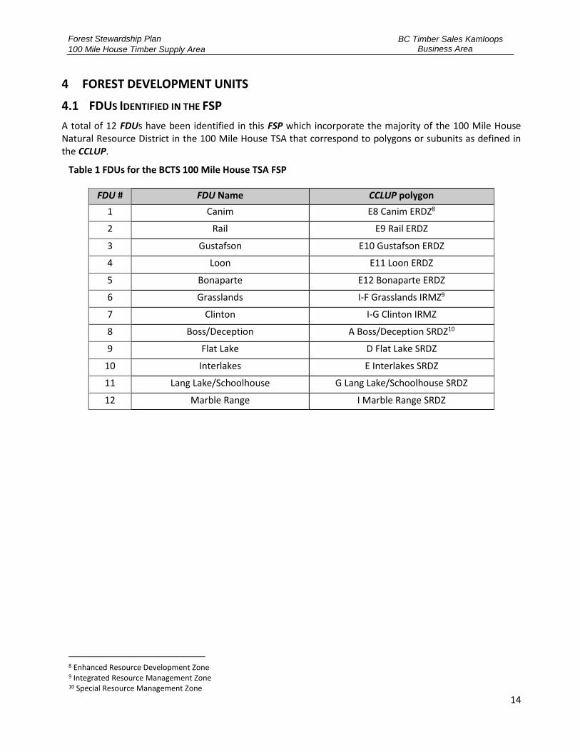
4.1 FDUS IDENTIFIED IN THE FSP
A total of 12 FDUs have been identified in this FSP which incorporate the majority of the 100 Mile House Natural Resource District in the 100 Mile House TSA that correspond to polygons or subunits as defined in the CCLUP.
Table 1 FDUs for the BCTS 100 Mile House TSA FSP
FDU # FDU Name CCLUP polygon
1 Canim E8 Canim ERDZ8
2 Rail E9 Rail ERDZ
3 Gustafson E10 Gustafson ERDZ
4 Loon E11 Loon ERDZ
5 Bonaparte E12 Bonaparte ERDZ
6 Grasslands I-F Grasslands IRMZ9
7 Clinton I-G Clinton IRMZ
8 Boss/Deception A Boss/Deception SRDZ10
9 Flat Lake D Flat Lake SRDZ
10 Interlakes E Interlakes SRDZ
11 Lang Lake/Schoolhouse G Lang Lake/Schoolhouse SRDZ
12 Marble Range I Marble Range SRDZ
8 Enhanced Resource Development Zone 9 Integrated Resource Management Zone 10 Special Resource Management Zone

Forest Stewardship Plan
100 Mile House Timber Supply Area
BC Timber Sales Kamloops Business Area
15
Figure 1 - FDUs for the BCTS 100 Mile House TSA
4.2 ITEMS IDENTIFIED IN THE FDUS
1) Appendix B – FSP Maps shows all the required content prescribed in FPPR section 14(2) and 14(3) that were in effect on the Submission Date:
• Ungulate winter range (UWR) areas;
• Wildlife habitat areas (WHA);
• Fisheries sensitive watersheds (FSW);
• Lakeshore management zones (LMZ, as established by the Government Actions Regulation);
• L1 lakes;
• Scenic areas;
• Community watersheds;
• Old growth management areas (OGMAs); and,
• Areas where commercial timber harvesting is prohibited by another enactment.
2) In addition, the areas within the FDU that are subject to a Timber Sales Licence, a Forest Licence to Cut, or a Road Permit granted by the FSP Holder, or Cutting / Road Permit issued by the District Manager, are in effect at the commencement date of this FSP. Table 2 and Table 3 outline the areas

Forest Stewardship Plan
100 Mile House Timber Supply Area
BC Timber Sales Kamloops Business Area
16
and roads being declared within this FSP.
Table 2 - Road Permits in Effect on the Submission Date
MH R20437.01 MH R21296.01 MH R21788.04 MH R22061.07 MH R20437.01
MH R20437.02 MH R21296.02 MH R21903.03 MH R22061.09 MH R20437.02
MH R20763.01 MH R21296.03 MH R21903.06 MH R22061.10 MH R20763.01
MH R20946.01 MH R21296.04 MH R21903.09 MH R22061.11 MH R20946.01
MH R20946.02 MH R21296.05 MH R21903.10 MH R22061.12 MH R20946.02
MH R20946.03 MH R21296.06 MH R21903.11 MH R22061.13 MH R20946.03
MH R20946.04 MH R21300.01 MH R21903.12 MH R22061.15 MH R20946.04
MH R21041.01 MH R21300.02 MH R21903.13 MH R22061.16 MH R21041.01
MH R21041.02 MH R21300.03 MH R21903.20 MH R22062.01 MH R21041.02
MH R21042.01 MH R21305.01 MH R21903.25 MH R22062.02 MH R21042.01
MH R21042.02 MH R21305.02 MH R21903.26 MH R22146.01 MH R21042.02
MH R21042.03 MH R21306.01 MH R21903.27 MH R22146.03 MH R21042.03
MH R21042.04 MH R21306.02 MH R21903.28 MH R22146.04 MH R21042.04
MH R21042.05 MH R21306.03 MH R21903.29 MH R22146.05 MH R21042.05
MH R21043.01 MH R21306.04 MH R21931.01 MH R22146.06 MH R21043.01
MH R21043.02 MH R21306.05 MH R21931.02 MH R22162.04 MH R21043.02
MH R21043.03 MH R21306.06 MH R21931.03 MH R22162.06 MH R21043.03
MH R21043.04 MH R21432.01 MH R22052.01 MH R22162.11 MH R21043.04
MH R21044.01 MH R21432.02 MH R22052.02 MH R22189.01 MH R21044.01
MH R21044.02 MH R21477.01 MH R22061.01 MH R22304.01 MH R21044.02
MH R21097.01 MH R21483.01 MH R22061.02 MH R22304.02 MH R21097.01
MH R21097.02 MH R21728.01 MH R22061.03 MH R22304.03 MH R21097.02
MH R21097.03 MH R21788.01 MH R22061.04 MH5289.30 MH R21097.03
Table 3 - Declared Areas
TSL Block ID
A93546 LA77F, LA8J0
A94471 RF90V, RF93F, RF94H, RF93C, RF93J, RF93B, RF944
A95069 RF8LD, RF8LG
A95188 MS7P1, MS898,
A95718 MS9DU, MS9E6
A94255 JI8Z5, JI8Z6, JI8Z7, JI8ZD, JI90K
A94350 JI93N, JI93M, JI93Y
A94258 JI909, JI90C
A93692 LA8DB, LA8DC, LA90L
A94238 JI8Z8 JI8ZB
A94239 JI8Z0, JI8Z1, JI8Z2, JI8Z9, JI8ZA
A93519 SN8JL, SN8TX
A94301 CR7GC, CR8YS
A94274 RF90S, RF90T, RF945, RF94Y, RF90R, RF90Q, RF90P
A93332 JI8D7, JI8U5

Forest Stewardship Plan
100 Mile House Timber Supply Area
BC Timber Sales Kamloops Business Area
17
TSL Block ID
A93841 LA7LF, LA8UQ, LA8UN, LA8UP
A94680 LA94C, LA94B, LA96D, LA9F2
A94770 MS9C8, MS9A1, MS9A2, MS9A0, MS99X, MS99W, MS8X0, MS8X7
A94281 MS92P MS92N MS92M
A94354 CH8UY CH93K CH8UW
A94238 JI8Z8, JI8ZB
A94239 JI8ZA, JI8Z1,JI8Z2,JI8Z9,JI8Z0
A94998 MS8WD, MS8WL, MS9CD, MS9CE, MS9CF, MS9CG, MS98U, MS98V,MS98X
A94788 LA8JJ, LA8JK
A94972 CC96L, CC976, CC9A3
A94929 LA7HR, LA8J2
A94930 LA8JF, LA977, LA8J3
A94869 JI9LU, JI8HJ
A95351 CC9N9, CC9NA, CC9NC, CC9ND, CC9NE, CC9NF, CC9NG, CC9NH, CC9NJ, CC9NK, CC9NL, CC9NM, CC9NN, CC9NP
A94273 BC8X8, BC8XB, BC8X9
A95188 MS898, MS7P1
A95255 SN98C, SN98A, SN8GX
A95257 JI8P9, JI7RY, JI7NS
A95415 RF9PZ, RF9PX
A95424 MS98S, MS98T, MS96A, MS98Q , MS98R, MS8VV
A95425 MS98P, MS98N, MS98M, MS98L, MS99U, MS99T, MS99S, MS9CC, MS9CB, MS9CA, MS9C9, MS8VZ, MS8VY, MS99Z, MS99Y, MS99V
A95455 SN7KG, SN9CU, SN7KM, SN9GM, SN7KH, SN7KJ, SN7M5
A95677 MS9E0, MH9DZ, MH9DY, MH9E1, MS9E2, MH9EG
A93319 JI8FP, JI8PH, JI8PJ
TA0073 LA9HW LA726 LA9HX
TA0232 LA9D7, LA9D5, LA9KC, LA9D6
TA0384 BC9J5 BC9J6 BC9J4 BC9J2 BC9J3 BC9J1
TA0142 BC9J7 BC9JC BC9J9 BC9J8 BC9JD
TA0058 RF9G4 RF912 RF9L1 RF919 RF9L5
TA0059 RF92C RF9HU RF9H3 RF9H4 RF9H5 RF9H6 RF9H7 RF99M RF9HA RF9HB RF9HC RF9P9
TA0071 RF9F1 RF9F0 RF9EZ RF9GQ RF9P7 RF9EV RF9GR RF9EY RF9EW RF9GX
TA0377 MS9MD, MS9MA, MS9M7, MS9MJ, MS9MG, MS9M4, MS9P3, MS9PH
TA0436 LA9MZ, LA9N0
TA0001 CC9FH, CC9FC
TA0376 CC9LW, CC9LY, CC9MY, CC9MX

Forest Stewardship Plan
100 Mile House Timber Supply Area
BC Timber Sales Kamloops Business Area
18
5 100 MILE HOUSE TSA RESULTS OR STRATEGIES
5.1 SOILS
Objective:
1. The objective set by government for soils is, without unduly reducing the supply of timber from British Columbia's forests, to conserve the productivity and the hydrologic function of soils.
FPPR s. 5
Applicable Area:
All FDUs.
Result or Strategy:
1. The TSM will notify each holder of a TSL or road permit awarded prior to commencing primary forestry activites that FPPR Soil Disturbance Limits (Section 35) and Permanent Access Strucuture Limits (Section 36) apply to the holder of the TSL or Road Permit as those sections were on the date of submission of this FSP.
2. In relation to the objective for Soils that is set in section 5 of the FPPR, and for Cutting Permits, and Road Permits issued by the District Manager, the FSP holder adopts as a result or strategy, FPPR Section 35, and FPPR section 36, as those section were on the date of submission of this FSP.
5.2 BIODIVERSITY – LANDSCAPE LEVEL
5.2.1 Spatial / Temporal Distribution of Cutblocks and Species Composition
Objective:
1. Conserve biological diversity through … objectives for … landscape connectivity, … species composition, temporal distribution of cutblocks …. These targets will be applied at the Landscape Unit Level … [and] will be based on the Biodiversity Conservation Guidelines [aka Biodiversity Guidebook published September 1995] …. Application of these guidelines in all zones and polygons is required …. Consistent with the targets, maintenance of deciduous (Aspen) and spruce components are important considerations on the Chilcotin Plateau.
2. To manage for grizzly bear, … and other sensitive habitats within the areas identified as riparian buffers, … and throughout the polygon under the biodiversity conservation strategy, including key leading spruce stands [or] including key leading deciduous stands [or] including key aspen stands
3. The objective set by government for wildlife and biodiversity at the landscape level is, without unduly reducing the supply of timber from British Columbia's forests and to the extent practicable, to design areas on which timber harvesting is to be carried out that resemble, both spatially and temporally, the patterns of natural disturbance that occur within the landscape.
CCLUP 90 Day Report
(February 1995)
CCLUP 90 Day Report, App. 3 Sub-
Units Targets
FPPR s. 9

Forest Stewardship Plan
100 Mile House Timber Supply Area
BC Timber Sales Kamloops Business Area
19
Definitions:
“Patch assessment unit” means an area unit generated by the overlay of:
a) landscape units (LUs) defined in the CCLUP LAO spatial data set: Cariboo-Chilcotin Landscape Units, and
b) the accompanying most current government endorsed Biogeoclimatic Ecosystem Classification (BEC) and Natural Disturbance Type (NDT) classification.
“Patch size assessment” means an assessment completed within the last 2 years, conducted consistent with the methodology outlined in “Regional Biodiversity Conservation Strategy Update Note #4”, that:
a) calculates the amount of each seral stage currently present in the patch assessment unit that is in small, medium and large size patches according to the criteria in Table 4, and
b) calculates the amount of the seral stage(s) created by the proposed harvest area that is in small, medium and large size patches according to the criteria in Table 4, and
c) is based on the most current forest inventory, or the most recent government endorsed patch size analysis, and
d) accounts for all completed and approved harvesting and wildfire impacts that are not reflected in the most current forest inventory or most recent government endorsed patch size analysis.
Table 4 – Patch size target ranges
Patch Size Class (target % range in each class)
NDT BEC unit 0-40ha 41-80ha 80-250ha 40-250ha
≥250ha
1 All 30-40 30-40 20-40 n/a 0
2 All 30-40 30-40 20-40 n/a 0
3 Douglas Fir throughout
SBSdw, SBSmh, SBSmw, ICHdk
20-30 25-40 30-50 n/a 0
3 Douglas Fir restricted or absent
all others 10-20 n/a n/a 10-20 60-80
4 All 30-40 30-40 20-30 n/a 0
Applicable Area:
All FDUs.
Result or Strategy:
1. The FSP holder will, prior to the submission of proposed harvest for approval, conduct a patch size assessment of the proposed harvest that demonstrates how the proposed harvest will either:
a) Within the patch assessment unit, maintain the patch size distribution of the seral stage

Forest Stewardship Plan
100 Mile House Timber Supply Area
BC Timber Sales Kamloops Business Area
20
created by the harvest consistent with the patch size target ranges outlined in Table 4, or
b) Within the patch assessment unit, trend the patch size distribution of the seral stage created by the harvest toward the patch size target ranges outlined in Table 4.
2. The FSP holder will be consistent with the patch size target ranges outlined in Table 4, unless one or more of the following criteria are met:
a) For the purpose of salvage where pine comprises ≥70% of the stand basal area, and ≥50% of the pine basal area is comprised of pine that is red, grey or green attacked mountain pine beetle, or
b) For the purpose of salvage by NRFLs with restrictions on harvest to the stand profile criteria specified in the license, or
c) Where ≥50% of the basal area of the stand is dead, or red, grey or green attacked bark beetle.
d) Within primary and interface fuel breaks in an approved community or regional wildfire plan, where impacts to mature and older seral stand attributes are minimized:
i. reduction of fine surface debris, ladder fuels and small diameter trees in intermediate and overtopped crown classes, and
ii. separation of tree crowns among individual trees or clumps within the dominant and co-dominant layers sufficient to mitigate the spread of a passive crown fire, to a maximum spacing of 6 metres between crowns.
e) Within a designated Wildfire Urban Interface area, reduction of fine surface debris, dead trees, ladder fuels and small diameter trees in intermediate and overtopped crown classes.
3. The FSP holder will, prior to the submission of proposed harvest for approval, conduct an assessment that demonstrates how the design of stand level retention has maintained the natural connectivity characteristics of mature and old forests in the area(s) of the proposed harvest, according to the Natural Connectivity Characteristics Frequency outlined in Table 5 and described in the Biodiversity Guidebook (1995).
Table 5 – Natural Connectivity Characteristics Frequency
NDT BEC unit Natural Connectivity Characteristics Frequency
upland to upland
upland to stream
upland to wetland
cross-elevational
wetland complex
stream riparian
island remnants
1 ESSFwc3, ESSFwk1, ICHwk2, ICHwk4, MHmm2
high
high
High
high
low-moderate
high
low
2 CWHds1, CWHms1, ESSFmv1, ESSFmw, ESSFxv, ICHmk3, SBSwk1
high
moderate
moderate
high
low
high
low
3 SBPSdc, SBPSmc, SBPSmk, SBPSxc,
low
low
Low
low
high
low
high
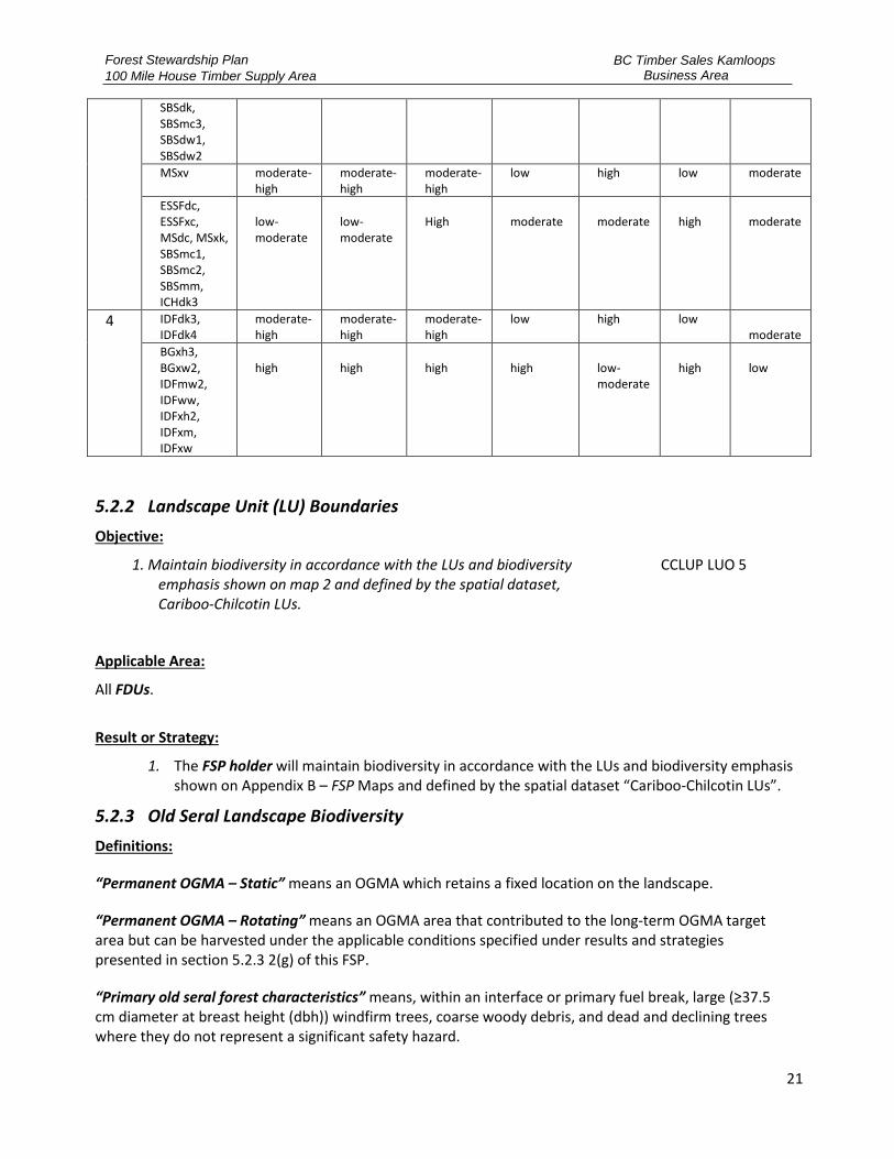
Forest Stewardship Plan
100 Mile House Timber Supply Area
BC Timber Sales Kamloops Business Area
21
SBSdk, SBSmc3, SBSdw1, SBSdw2
MSxv moderate-high
moderate-high
moderate-high
low high low moderate
ESSFdc, ESSFxc, MSdc, MSxk, SBSmc1, SBSmc2, SBSmm, ICHdk3
low-moderate
low-moderate
High
moderate
moderate
high
moderate
4 IDFdk3, IDFdk4
moderate-high
moderate-high
moderate-high
low high low moderate
BGxh3, BGxw2, IDFmw2, IDFww, IDFxh2, IDFxm, IDFxw
high
high
high
high
low-moderate
high
low
5.2.2 Landscape Unit (LU) Boundaries
Objective:
1. Maintain biodiversity in accordance with the LUs and biodiversity emphasis shown on map 2 and defined by the spatial dataset, Cariboo-Chilcotin LUs.
CCLUP LUO 5
Applicable Area:
All FDUs.
Result or Strategy:
1. The FSP holder will maintain biodiversity in accordance with the LUs and biodiversity emphasis shown on Appendix B – FSP Maps and defined by the spatial dataset “Cariboo-Chilcotin LUs”.
5.2.3 Old Seral Landscape Biodiversity
Definitions:
“Permanent OGMA – Static” means an OGMA which retains a fixed location on the landscape.
“Permanent OGMA – Rotating” means an OGMA area that contributed to the long-term OGMA target area but can be harvested under the applicable conditions specified under results and strategies presented in section 5.2.3 2(g) of this FSP.
“Primary old seral forest characteristics” means, within an interface or primary fuel break, large (≥37.5 cm diameter at breast height (dbh)) windfirm trees, coarse woody debris, and dead and declining trees where they do not represent a significant safety hazard.
Forest Stewardship Plan
100 Mile House Timber Supply Area
BC Timber Sales Kamloops Business Area
22
“Shallow and Moderate Snowpack Zones” means the following biogeoclimatic units within the CCLUP area: BG –all subzones, IDFxm, IDFxw, IDFdk3, IDFdk4, SBPSxc, MSxk, and SBSmh south of Quesnel.
“Thinning from below” means a silvicultural treatment that is in compliance with the General Wildlife Measures for a designated Mule Deer Winter Range (MDWR) in the shallow or moderate snowpack zone, in which trees are removed from intermediate and overtopped crown classes leaving the larger trees on site.
“Transitional OGMA” means an OGMA area which exists until it is replaced by other old forest in that LU-BEC unit or 20 years from the June 25, 2010 effective date of the CCLUP LUO.
Objective:
1. Retain old forest and natural successional processes by maintaining as No-harvest area the permanent OGMA-static, permanent OGMA-rotating, and transitional OGMAs as shown on map 3 and defined by the spatial dataset.
CCLUP LUO 8
Applicable Area:
All FDUs.
Result or Strategy:
1. The FSP holder will not conduct primary forest activities in permanent OGMA-static, permanent OGMA-rotating, or transition OGMA, as defined by the spatial dataset Cariboo-Chilcotin Old Growth Management Areas, unless one or more of the following criteria are met:
a) Harvesting incursions of 10 ha or less that better align the OGMA boundaries with intended geographic features where the OGMA boundaries follow a geographic feature, which include:
i. creeks or existing roads that were established prior to the OGMA establishment, or
ii. other geographic features in consultation with appropriate FLNRORD staff.
b) Where harvest is essential for insect control, and all known Infestation sites on crown provincial forest land within 500m of the infested OGMA are addressed before or in conjunction with entries into the OGMA.
c) Road or fence construction where no other practicable location is available.
d) Thinning-from-below to enhance old seral forest attributes in OGMAs located within designated MDWR in the shallow and moderate snowpack zones.
e) Within primary and interface fuel breaks, in an approved community or regional wildfire plan, where impacts to primary old seral forest characteristics are minimized by:
i. reduction of fine surface debris, ladder fuels and small diameter trees in intermediate and overtopped crown classes, and
ii. separation of tree crowns among individual trees or clumps within the dominant and co-dominant layers sufficient to mitigate the spread of a passive crown fire, to a maximum spacing of 6 metres between crowns.

Forest Stewardship Plan
100 Mile House Timber Supply Area
BC Timber Sales Kamloops Business Area
23
f) Guyline tiebacks and no other practicable location is available.
g) In a permanent OGMA-rotating, where:
i. mature conifer mortality is ≥50% by basal area for trees ≥17.5 cm dbh, or
ii. stand age is ≥200 years and stand is ≥70% Lodgepole pine by basal area for trees ≥12.5 cm dbh.
h) In a Transition OGMA where:
i. conifer mortality is ≥50% of stand basal area, and
ii. equivalent old seral forest exists in locations contributing to the permanent OGMA target in the same LU-BEC unit.
2. The TSL, cutting permit and/or road permit application in conjunction with RESULTS depletion reporting completed by the FSP holder will serve to address the reporting requirement associated with changes to OGMAs resulting from harvesting or road building conducted under Clause 1 of this strategy.
5.2.4 Mature + Old Seral Landscape Biodiversity
Definitions:
“Seral assessment unit” means an area unit generated by the overlay of:
a) landscape units (LUs) and biodiversity emphasis objective (BEO) defined in the Cariboo-Chilcotin Land-Use Plan Land Act Order spatial data set: Cariboo-Chilcotin Landscape units, and
b) the accompanying most current government endorsed Biogeoclimatic Ecosystem Classification (BEC), and
c) the LU/BEC amalgamations listed at https://www2.gov.bc.ca/assets/gov/farming-natural-resources-and-industry/natural-resource-use/land-water-use/crown-land/land-use-plans-and-objectives/cariboo-region/cariboochilcotin-rlup/biogeoclimatic_unit_amalgamation_table_2007.pdf, and
d) a current productive forest landbase dataset.
“Severely Burned” means as identified in the Burn Severity layer provided by the province, and in the absence of this information as defined, confirmed in the field, and documented by a QRP.
“Stand attributes” means amounts and characteristics, consistent with the BEC subzone and variant, for large living trees, standing dead trees, coarse woody debris, tree species diversity, and structural diversity, as described in Appendix 5 of the Biodiversity Guidebook (1995).
“M+O seral target area” means the target for the minimum amount of mature seral or older forest present in a seral assessment unit, which is determined by the applicable target % in Table 6 multiplied by the total productive forest area of the seral assessment unit.
“mature seral or older forest” means Mature Plus Old stand age as defined in Table 6 for the applicable BEC zone.
“Mature plus old seral deficit unit (M+O deficit unit)” means a seral assessment unit where, at the time
Forest Stewardship Plan
100 Mile House Timber Supply Area
BC Timber Sales Kamloops Business Area
24
of submission of proposed harvest for approval, the amount of mature seral or older forest present in a seral assessment unit is less than the M+O seral target area, based on stand age in the most current forest inventory, and accounting for all completed and approved harvesting and wildfire impacts that are not reflected in the most current forest inventory.
“Mature recruitment area” means a less than mature seral aged stand in a M+O deficit unit that is designated by any FSP holder and submitted to FLNRORD as being reserved from harvest to allow sufficient recruitment into mature seral age, until the seral assessment unit is no longer in M+O seral deficit. The sufficient amount of mature recruitment area is calculated after first accounting for all forest less than mature seral age in No-harvest areas in the seral assessment unit. Mature recruitment areas are selected from stands:
a) in order of priority from oldest to youngest available, and
b) displaying stand attributes most conducive to regaining mature seral condition as soon as possible, and
c) that contribute to achieving or trending towards patch size target ranges outlined in Table 3 for the applicable NDT/BEC unit.
Objective:
1. The objective set by government for Mature plus Old Seral landscape biodiversity is to manage for Mature plus Old Seral targets set out in Table 7 of the CCLUP Biodiversity Conservation Strategy (BCS) according to the LUs and biogeoclimatic subzone variant units within the plan area.
CCLUP 90-Day Report p.
60-133
Applicable Area:
All FDUs.
Result or Strategy:
1. The FSP holder will not harvest mature seral or older forest in a M+O deficit unit, or cause the amount of mature seral or older forest in a seral assessment unit to be less than the applicable M+O seral target area, unless one or more of the following criteria are met:
a) For the purpose of salvage where pine comprises ≥70% of the stand basal area, and ≥50% of the pine basal area is comprised of pine that is red, grey or green attacked mountain pine beetle, and sufficient mature recruitment area has been reserved from harvest, or
b) For the purpose of salvage by non-replaceable forest licences (NRFLs) with restrictions on harvest to the stand profile criteria specified in the license, and sufficient mature recruitment area has been reserved from harvest, or
c) Where ≥50% of the basal area of the stand is dead, or red, grey or green attacked bark beetle, and sufficient mature recruitment area has been reserved from harvest.
d) For clauses (a), (b), and (c) above, mature and older stands will not be drawn-down lower than the corresponding target as shown in Table 7.
e) Partial harvest where the FSP holder ensures that after harvest the stand volume and stand attributes are ≥ 70% of the pre-harvest stand, and
Forest Stewardship Plan
100 Mile House Timber Supply Area
BC Timber Sales Kamloops Business Area
25
i. all diameter classes and species are represented in proportion to the pre-harvest stand condition as described in the stand stock tables of the cruise compilation for that stand; or
ii. the harvesting is a thinning from below treatment that removes only intermediate and overtopped crown classes to a maximum of 30% of stand basal area.
f) Where harvest is essential for insect control.
g) Within primary and interface fuel breaks, in an approved community or regional wildfire plan where impacts to mature and older seral stand attributes are minimized:
i. reduction of fine surface debris, ladder fuels and small diameter trees in intermediate and overtopped crown classes, and
ii. separation of tree crowns among individual trees or clumps within the dominant and co-dominant layers sufficient to mitigate the spread of a passive crown fire, to a maximum spacing of 6 metres between crowns.
h) Within a designated Wildfire Urban Interface area, reduction of fine surface debris, dead trees, ladder fuels and small diameter trees in intermediate and overtopped crown classes.
2. The FSP holder will not harvest forest less than mature seral or older forest stand age in a M+O deficit unit unless sufficient mature recruitment area has been reserved from harvest.
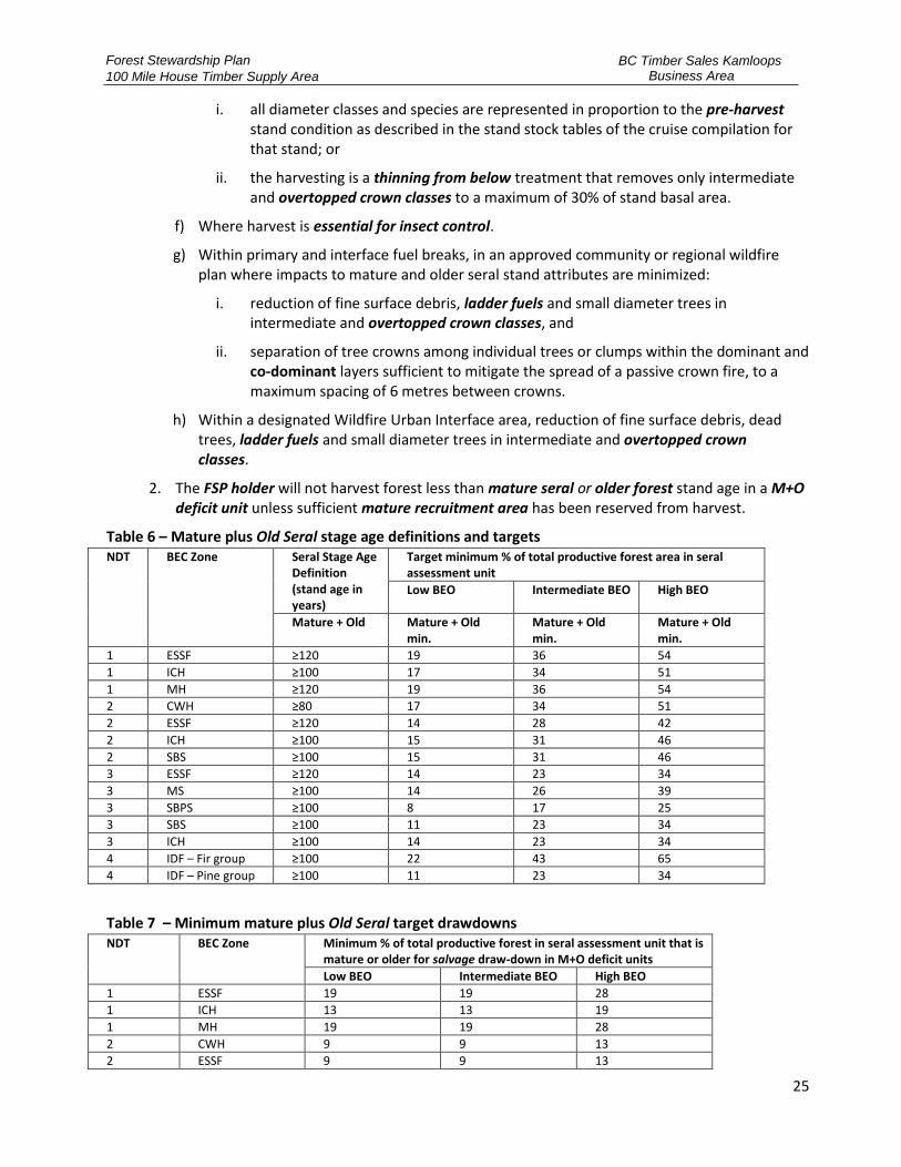
Table 6 – Mature plus Old Seral stage age definitions and targets NDT BEC Zone Seral Stage Age
Definition (stand age in years)
Target minimum % of total productive forest area in seral assessment unit
Low BEO Intermediate BEO High BEO
Mature + Old Mature + Old min.
Mature + Old min.
Mature + Old min.
1 ESSF ≥120 19 36 54
1 ICH ≥100 17 34 51
1 MH ≥120 19 36 54
2 CWH ≥80 17 34 51
2 ESSF ≥120 14 28 42
2 ICH ≥100 15 31 46
2 SBS ≥100 15 31 46
3 ESSF ≥120 14 23 34
3 MS ≥100 14 26 39
3 SBPS ≥100 8 17 25
3 SBS ≥100 11 23 34
3 ICH ≥100 14 23 34
4 IDF – Fir group ≥100 22 43 65
4 IDF – Pine group ≥100 11 23 34
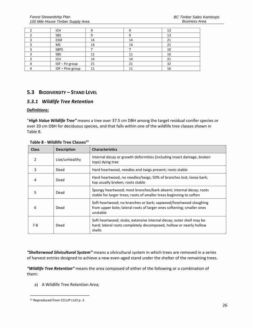
Table 7 – Minimum mature plus Old Seral target drawdowns NDT BEC Zone Minimum % of total productive forest in seral assessment unit that is
mature or older for salvage draw-down in M+O deficit units
Low BEO Intermediate BEO High BEO
1 ESSF 19 19 28
1 ICH 13 13 19
1 MH 19 19 28
2 CWH 9 9 13
2 ESSF 9 9 13
Forest Stewardship Plan
100 Mile House Timber Supply Area
BC Timber Sales Kamloops Business Area
26
2 ICH 9 9 13
2 SBS 9 9 13
3 ESSF 14 14 21
3 MS 14 14 21
3 SBPS 7 7 10
3 SBS 11 11 16
3 ICH 14 14 21
4 IDF – Fir group 21 21 32
4 IDF – Pine group 11 11 16
5.3 BIODIVERSITY – STAND LEVEL
5.3.1 Wildlife Tree Retention
Definitions:
“High Value Wildlife Tree” means a tree over 37.5 cm DBH among the target residual conifer species or over 20 cm DBH for deciduous species, and that falls within one of the wildlife tree classes shown in Table 8.
Table 8 - Wildlife Tree Classes11
Class Description Characteristics
2 Live/unhealthy Internal decay or growth deformities (including insect damage, broken tops) dying tree
3 Dead Hard heartwood, needles and twigs present; roots stable
4 Dead Hard heartwood, no needles/twigs; 50% of branches lost; loose bark; top usually broken; roots stable
5 Dead Spongy heartwood; most branches/bark absent; internal decay; roots stable for larger trees; roots of smaller trees beginning to soften
6 Dead Soft heartwood; no branches or bark; sapwood/heartwood sloughing from upper bole; lateral roots of larger ones softening; smaller ones unstable
7-8 Dead Soft heartwood; stubs; extensive internal decay; outer shell may be hard; lateral roots completely decomposed, hollow or nearly hollow shells
“Shelterwood Silvicultural System” means a silvicultural system in which trees are removed in a series of harvest entries designed to achieve a new even-aged stand under the shelter of the remaining trees.
“Wildlife Tree Retention” means the area composed of either of the following or a combination of them:
a) A Wildlife Tree Retention Area;
11 Reproduced from CCLUP LUO p. 2.

Forest Stewardship Plan
100 Mile House Timber Supply Area
BC Timber Sales Kamloops Business Area
27
b) The area of wildlife trees retained within a cutblock and/or TSL based on the following formula:
Area = (Gross Block Area of the Cutblock) * (Basal Area Reserved from Harvesting) (Original Basal Area of the Cutblock)
Objective: 1. Where harvesting removes ≥50% of the pre-Harvest stand basal area or
where the harvest is part of a shelterwood silvicultural system, meet or exceed the minimum areas for wildlife tree retention for each harvest area (cutblock or TSL) as set out in CCLUP LUO Schedule 1 Wildlife Tree Retention Targets.
CCLUP
LUO 6
2. Where practicable, in partially cut stands, where harvesting removes ≤50% of the pre-harvest basal area, retain high-value wildlife trees up to the limits in Schedule 1.
CCLUP LUO 7
Applicable Area:
All FDUs.
Result or Strategy:
1. The FSP Holder adopts FPPR section 68 (Coarse Woody Debris) as a requirement:
a) An agreement holder who carries out timber harvesting must retain on a cutblock a minimum of 4 logs per ha, each being a minimum of 2 m in length and 7.5 cm in diameter at one end.
b) An agreement holder is exempt from strategy 1(a) if:
i. The holder's agreement or an enactment requires the holder to act in a manner contrary to that set out in strategy (1), or
ii. The holder carries out on the cutblock a controlled burn that is authorized under an enactment, or
iii. The holder is a fibre recovery tenure holder.
2. The FSP holder, consistent with Table 5 – Natural Connectivity Characteristics Frequency, will establish WTRA that have stand attributes that contribute area, in amounts and characteristics, suitable for wildlife habitat in the following priority areas:
a) Wildlife Habitat Areas
b) Habitat and features suitable for species at risk
c) Ungulate management areas (i.e. Deer Winter Range, Moose Management Zones)
d) Riparian Management Areas and Lakeshore Management Zones
e) Scenic areas
f) Trail buffers
g) Other no harvest areas (excluding OGMA)
h) Patches of timber ≥ 0.25ha within 500m distance of an existing timber edge, or other

Forest Stewardship Plan
100 Mile House Timber Supply Area
BC Timber Sales Kamloops Business Area
28
WTRA.
3. Ensure that a windthrow hazard assessment is completed by a QRP prior to establishing a cutblock or road for WTRAs that provides recommendations around the design and retention of the WTRA.
4. The FSP holder upon completion of harvesting within a LU-BEC Unit:
a) will maintain the WTRAs established within the cutblocks/TSLs until the trees on the Net Area to be Reforested (NAR) of the cublock to which the WTRA relates have developed attributes that are consistent with a mature seral condition, as per FPPR s. 67.
b) Will meet or exceed the minimum targets specified in Appendix C – Wildlife Tree Retention Targets by LU-BEC Unit for wildlife tree retention expressed as a percentage of the gross harvest area of the TSL or Cutting Permit where:
i. Harvesting removes greater than or equal to 50 % of the gross merchantable basal area, or
ii. Where harvesting is part of a shelterwood silvicultural system, and
c) Will retain high value wildlife trees up to the targets specified in Appendix C – Wildlife Tree Retention Targets by LU-BEC Unit and expressed as a percentage of the gross harvest area of the TSL or Cutting Permit where harvesting removes less than 50% of the pre-harvest basal area.
5. The FSP holder may propose amendments or substitutions to established WTRAs12 where a QRP has determined that:
a) the WTRA causes a concern for public safety;
b) where harvesting is essential for insect control;
c) the ecological value of the WTRA has been lost due to windfall, blowdown or other disturbance;
d) harvesting is required to provide road access where no alternative practicable option for road location exists;
e) construction of fences where no alternative practicable option for a fence location exists;
f) harvesting is required to ensure operationally feasible cutblock boundaries.
g) the existing WTRA, impedes or limits operations and there is no other practicable option.
6. If the FSP holder authorizes or conducts timber harvesting within a WTRA for the reasons outlined in strategy (5), then the WTRA will be replaced with an equal area of WTRA with similar stand characteristics13, that is within or adjacent to the existing TSL or Cutting Permit.
7. The FSP holder will report WTRA changes within 1 year of replacement through RESULTS depletion reporting.
8. The FSP holder will maintain the WTRAs established with the cutblocks/TSLs until the trees on the NAR of the cutblock to which the WTRA relates have developed attributes that are consistent with a mature seral age condition, as defined by ages, in Table 5 – Natural Connectivity Characteristics Frequency.
12 CCLUP Regional Biodiversity Conservation Strategy Update Note #12. 13 As per FPPR Schedule 1 Factor 3 (2).
Forest Stewardship Plan
100 Mile House Timber Supply Area
BC Timber Sales Kamloops Business Area
29
5.3.2 Riparian Areas
Definitions:
“Machine Free Zone” means an area where the tracks or wheels of ground-based machinery are not permitted.
“Major Wildlife Features” are, for the purposes of LUO 22, interpreted to be key wildlife features which trigger Identified Wildlife Management Strategies (IWMS) as per Species at Risk – General (5.5.1.1), as well as Moose (5.5.4.1), Grizzly Bear (5.5.2.1), Bighorn Sheep (5.5.2.2), Salmon (5.5.4.3) and Critical Fish Habitat (5.5.3.1) of this FSP. No wildlife habitat features have been established by order as of the date of this FSP;
“Percent Retention” or “Retention” means the percentage of the basal area (equal to or greater than 12.5 cm DBH) within the Riparian Management Zone (RMZ) that is retained.
“Riparian attributes” means in channel, off channel and adjacent to channel areas, that contribute to the presence of fish, water quality, water temperature, forage and stream structure and is determined to be valuable by a QRP.
“Windthrow Hazard Assessment” means an assessment as per the Mitchell field assessment card14.
Objective:
1. Maintain riparian reserve zones (RRZ) as no harvest areas. CCLUP LUO
20 (a)
2. Despite objective CCLUP LUO 20(a), primary forest activities may be carried out in a RRZ for the following purposes:
a) Where harvesting is essential for insect control to curtail severe damage to forest values at the landscape level in a BMU classified as suppression for that insect pest,
b) Felling or modifying a tree that is a safety hazard, if there is no other practicable option for addressing the safety hazard,
c) Constructing a stream crossing,
d) Creating a corridor for full suspension yarding,
e) Creating guyline tiebacks,
f) Felling or modifying a tree under an occupant license to cut, master license to cut or free use permit issues in respect of an area that is subject to a license permit, or other form of tenure issued under the Land Act, Mining Right of Way Act, Ministry of Lands Parks and Housing Act or Petroleum and Natural Gas Act, if the felling or modification is for a purposed expressly authorized under that license, permit or tenure,
CCLUP LUO 20 (b)
14 Windthrow Calibration Field Card: https://www.for.gov.bc.ca/isb/forms/lib/FS712-4.pdf
Forest Stewardship Plan
100 Mile House Timber Supply Area
BC Timber Sales Kamloops Business Area
30
g) Felling or modifying a tree for the purposed of establishing or maintaining an interpretive forest site, recreation site, recreation facility or recreation trail.
3. Except at road crossings, retain windfirm trees and other vegetation in RMZ on all S4 streams, sufficient to:
a) Maintain streambank stability and channel processes, and 1. Minimize adverse changes to stream shade and organic input
to the stream.
CCLUP LUO 21
4. In RMZs on W3 and W4 wetlands and L3 and L4 lakes retain deciduous patches, significant wildlife trees and major wildlife features.
CCLUP LUO 22
5. For L3 lakes and selected L1 lakes shown in map 6c and defined by the spatial dataset, Cariboo-Chilcotin L3/L1 Lakes, maintain a 10 meter RRZ.
CCLUP LUO 23
Applicable Area:
All FDUs.
Result or Strategy:
1. The FSP holder will, as per section 12.1(2) of the FPPR, adopt as a Strategy FPPR section 47 to 51, 52(2), 53, and 55 to 57 as written on the date of FSP submission, and the Practice Requirements as presented in Legislation, during the term of this plan, except for the following prescribed circumstances:
a) Where a Lakeshore Classification or Lake Management Classification has been established in accordance with section 180(h) of the FRPA or section 93.4 of the Land Act, the FSP holder adopts the results or strategies in Lakeshore Management (5.9.2) of this FSP, and
b) For L3 lakes and selected L1 lakes, defined in the CCLUP LUO spatial data set “Cariboo-Chilcotin L3/L1 Lakes” displayed in Appendix B – FSP Maps, the FSP holder will maintain a 10 m RRZ.
2. The FSP holder will, for those riparian features requiring a RRZ of greater than 0 m as per FPPR section 47(4), 48(3) or 49(2), or strategy (1) above, will maintain the RRZ as a No-harvest area except for the following prescribed circumstances:
a) Where harvesting is essential for insect control; and all infestiation sites within 500m of Riparian Reserves Zone are addressed prior to or in conjuction with harvesting, prior to entry in the Reserve Zone, or
b) Felling or modifying a tree that is a safety hazard as per FPPR s. 51(1), if there is no other practicable option for addressing the safety hazard and the felled or modified portion of the tree is retained on-site, or
c) Constructing a stream crossing, or
d) Creating a corridor for full suspension yarding, or
e) Creating guyline tiebacks, or
f) With a Section 16 approval from the District Recreation Officer, felling or modifying a tree for the purpose of establishing or maintaining an interpretive forest site, recreation

Forest Stewardship Plan
100 Mile House Timber Supply Area
BC Timber Sales Kamloops Business Area
31
site, recreation facility, or recreation trail.
3. The FSP holder will maintain riparian management zone as defined in Table 9 except in the following prescribed circumstances, where impacts to riparian attributes are minimized:
a) Within primary and interface fuel breaks, in an approved community or regional wildfire plan for:
i. reduction of fine surface debris, ladder fuels and small diameter trees in intermediate and overtopped crown classes, and
ii. a thinning from below harvest treatment that removes only intermediate and overtopped crown classes to a maximum of 30% of stand basal area.
b) Within a designated Wildfire Urban Interface area, reduction of fine surface debris, dead trees, ladder fuels and small diameter trees in intermediate and overtopped crown classes.
4. The FSP holder adopts as results or strategies, for the purposes of section 12(3) of the FPPR, the results or strategies for retention of trees in RMAs, presented in Table 9 - Riparian Retention Requirements
Table 9 - Riparian Retention Requirements
Riparian Class RRZ Width
(m) RMZ
Width (m) RMA
Width (m)
Basal Area Retention in RMZ(%)15
Low Windthrow Hazard
High Windthrow Hazard
S1-A Stream 0 100 100 ≥20 ≥50
S1-B Stream 50 20 70 ≥20 ≥50
S2 Stream 30 20 50 ≥25 ≥25
S3 Stream 20 20 40 ≥25 ≥25
S4 Stream 0 30 30 ≥25 ≥25
S5 Stream 0 30 30 ≥25 ≥25
Large S6 Stream (S6-L)
(≥ 1.5 m and ≤ 3 m in width) 10 15 25 ≥25 ≥25
Small S6 Stream (S6-S)
(≤ 1.5 m in width) 0 20 20 ≥5 ≥5
Classified L1 Lake 10 10 20 ≥25 ≥25
15 As assessed and documented through the BCTS Windthrow Calibration Field Card, pg 5-15: https://www.for.gov.bc.ca/isb/forms/lib/FS712-4.pdf
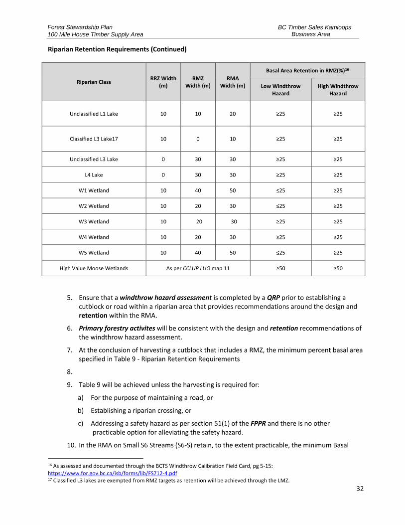
Forest Stewardship Plan
100 Mile House Timber Supply Area
BC Timber Sales Kamloops Business Area
32
Riparian Retention Requirements (Continued)
Riparian Class RRZ Width
(m) RMZ
Width (m) RMA
Width (m)
Basal Area Retention in RMZ(%)16
Low Windthrow Hazard
High Windthrow Hazard
Unclassified L1 Lake 10 10 20 ≥25 ≥25
Classified L3 Lake17 10 0 10 ≥25 ≥25
Unclassified L3 Lake 0 30 30 ≥25 ≥25
L4 Lake 0 30 30 ≥25 ≥25
W1 Wetland 10 40 50 ≤25 ≥25
W2 Wetland 10 20 30 ≤25 ≥25
W3 Wetland 10 20 30 ≥25 ≥25
W4 Wetland 10 20 30 ≥25 ≥25
W5 Wetland 10 40 50 ≤25 ≥25
High Value Moose Wetlands As per CCLUP LUO map 11 ≥50 ≥50
5. Ensure that a windthrow hazard assessment is completed by a QRP prior to establishing a cutblock or road within a riparian area that provides recommendations around the design and retention within the RMA.
6. Primary forestry activites will be consistent with the design and retention recommendations of the windthrow hazard assessment.
7. At the conclusion of harvesting a cutblock that includes a RMZ, the minimum percent basal area specified in Table 9 - Riparian Retention Requirements
8.
9. Table 9 will be achieved unless the harvesting is required for:
a) For the purpose of maintaining a road, or
b) Establishing a riparian crossing, or
c) Addressing a safety hazard as per section 51(1) of the FPPR and there is no other practicable option for alleviating the safety hazard.
10. In the RMA on Small S6 Streams (S6-S) retain, to the extent practicable, the minimum Basal
16 As assessed and documented through the BCTS Windthrow Calibration Field Card, pg 5-15: https://www.for.gov.bc.ca/isb/forms/lib/FS712-4.pdf 17 Classified L3 lakes are exempted from RMZ targets as retention will be achieved through the LMZ.
Forest Stewardship Plan
100 Mile House Timber Supply Area
BC Timber Sales Kamloops Business Area
33
Area describe in Table 9 - Riparian Retention Requirements Where practicable, retention will be in clumps of Deciduous trees and shrubs (i.e. aspen, cottonwood, birch, willow, alder, red osier dogwood), and other mature and immature conifer species as they exist on site.Table 9 - Riparian Retention Requirements
11. Table 9 - Riparian Retention RequirementsDuring and at the completion of primary forest activities within the established RMA of S4, S5, or S6 streams, the FSP holder will:
a) Retain to the extent practicable, brush species, advanced regeneration, non-merchantable conifers and non-commercial stems, and
b) Maintain a machine free zone of 5 metres from each side of the stream bank, except where a FSP holder is:
i. Establishing a stream crossing, or
ii. Carrying out yarding across or adjacent to the stream, or
iii. To alleviate a safety hazard as per section 51(1) of the FPPR and there is no other practicable option for alleviating the safety hazard.
12. In addition to strategy (1), the FSP holder will, where there is an established RMZ on W3, W4, L3 and L4 upon the conclusion of harvesting, have retained the following to the extent practicable:
a) Deciduous trees and shrubs (i.e. aspen, cottonwood, birch, willow, alder, red osier dogwood),
b) Significant wildlife trees, and
c) Major Wildlife Features including but not limited to:
i. Den sites, and ii. Mineral licks or wallows.
5.4 WATER
5.4.1 Water in Community Watersheds
Definitions:
“Community Watershed Assessment” means an assessment of the cumulative hydrological effects of existing and proposed harvesting and road construction within a community watershed, completed by a QRP, which evaluates the potential for activities to result in:
a) A material adverse impact on the quantity of water or the timing of the flow of the water from the licensed waterworks as identified in Appendix B – FSP Maps; and
b) The water from the licensed waterworks having a material adverse impact on human health that cannot be addressed by required water treatment;
A Community Watershed Assessment includes recommendations to mitigate potential material adverse impacts and where it relates to an existing assessment, is considered relevant if the extent and magnitude of the proposed activities has been included in the scope of the assessment.
“Licensed Waterworks” means a water supply intake or a water storage and delivery infrastructure that

Forest Stewardship Plan
100 Mile House Timber Supply Area
BC Timber Sales Kamloops Business Area
34
is licensed under the Water Act or authorized under an operating permit issued under the Drinking Water Protection Act.
Objective:
1. The objective set by government for water being diverted for human consumption through a licensed waterworks in a community watershed is to prevent to the extent described in [FPPR s. 8.2] subsection (3) the cumulative hydrological effects of primary forest activities within the community watershed from resulting in:
a) A material adverse impact on the quantity of water or the timing of the flow of water to the waterworks, or
b) The water from the waterworks having a material adverse impact on human health that cannot be addressed by water treatment required under:
i. An enactment, or
ii. The license pertaining to the waterworks.
2. The objective set by government under [FPPR s. 8.2] subsection (2) applies only to the extent that it does not unduly reduce the supply of timber from British Columbia's forests.
3. If satisfied that the objective set out in [FPPR s. 8.2] subsection (2) is not required to provide special management, the minister responsible for the Wildlife Act must exempt a person from the requirement to specify a result or strategy in relation to the objective.
4. If satisfied that the objective set out in [FPPR s. 8.2] subsection (2) is addressed, in whole or in part, by an enactment, the minister responsible for the Wildlife Act must exempt a person from the requirement to specify a result or strategy in relation to the objective set out in subsection (2) to the extent that the objective is already addressed.
FPPR s. 8.2
Applicable Area:
Clinton Community Watershed located within the Marble Range, Gustafson and Clinton FDUs.
Result or Strategy:
1. In relation to the objective for water in community watersheds set out in section 8.2 of the FPPR, for the portions for the FDUs that fall within the community watershed, the FSP holder adopts as a result or strategy FPPR sections 59 through 63, and 84 as those sections were on the date of submission of this FSP.
2. In addition to these practice requirements, the FSP holder will:
a) If a community watershed assessment has been completed for the applicable community watershed, and is considered relevant by the elected representatives of the community to

Forest Stewardship Plan
100 Mile House Timber Supply Area
BC Timber Sales Kamloops Business Area
35
which the watershed applies and the relevant Ministry representative responsible for community watersheds, conduct primary forest activities consistent with the recommendations of the community watershed assessment; or
b) If a community watershed assessment has not been completed for the applicable community watershed or if the applicable assessment is older than 5 years, the FSP holder will:
i. Ensure a community watershed assessment is completed prior to submission of a cutblock or road within the community watershed, and
ii. Conduct primary forest activities consistent with the recommendations of the community watershed assessment.
3. For harvesting or road construction planned within the Community Watershed Boundaries as shown in Appendix B – FSP Maps, prior to authorizing or conducting harvesting, or road construction activities, the FSP holder will:
a) Notify the community watershed elected official, and known Points of Diversion Permit holder within the community watershed, and provide these parties a minimum of 60 days (or less as approved by the applicable FLNRORD District Manager) to identify any issues or concerns they may have in the vicinity of the proposed forestry activities.
b) Have a QRP prepare a plan to incorporate concerns raised in a) above, and where practicable, mitigate the impacts of the proposed forestry activities. The FSP holder will share the plan with the applicable community watershed officials and make available the plan to Point Diversion Permit holders.
c) If agreement cannot be reached between the FSP holder and the elected representative, conduct a meeting with FLNRORD, FSP holder and the affected community watershed elected official. If agreement is not reached, the direction will be obtained from the District Manager and the FSP holder will implement the direction.
4. Ensure that the assessment completed by a QRP, provides recommendations that will achieve the objectives for water in community watersheds and other objectives set by government for the applicable land base for primary forest activities that could result in:
a) A material adverse impact on the quantity of water or the timing of the flow of the water from the waterworks, damage to a licensed Waterworks, or
b) The water from the waterworks having a material adverse impact on human health that cannot be addressed by water treatment required under:
i. an enactment, or
ii. the license pertaining to the waterworks.
5. The Holder of the FSP will conduct primary forest activities consistent with the recommendations of the community watershed assessment.
5.4.2 Hydrology
Definitions:
“Disturbance Levels” for the purposes of this FSP, objectives from the CCLUP that define Disturbance Levels shall be taken to mean equivalent clearcut area (ECA).

Forest Stewardship Plan
100 Mile House Timber Supply Area
BC Timber Sales Kamloops Business Area
36
“Key Watershed” includes Horsefly River18 , Bridge Creek and Bonaparte River Watersheds.
Objective:
1. As required under the FPC when disturbance levels exceed 25% and in keywatersheds, a watershed assessment should be undertaken to ensure themaintenance of critical fish and wildlife habitat and hydrological stability.
CCLUP 90- Day Report,
p. 160
2. Development within watersheds or portions of watersheds in the SRDZshould be consistent with the watershed assessment prescriptions of theFPC designed to avoid detrimental cumulative impacts. Completewatershed assessments for high priority fisheries watersheds in the SRDZ,notably the Horsefly and Bonaparte.
CCLUP 90- Day Report, p. 179-180
3. Manage the Horsefly River watershed for hydrologic stability throughwatershed assessment, restoration work and monitoring programs.
CCLUP 90- Day Report,
p. 62
4. Manage the Bonaparte River watershed for hydrologic stability throughwatershed assessment and monitoring programs (Bonaparte, Clinton, andLoon FDUs).
CCLUP 90 -Day Report,
p. 106
5. Manage the Bridge Creek watershed for hydrologic stability throughwatershed assessment and monitoring programs (Interlakes FDU).
CCLUP 90- Day Report,
p. 70
Applicable Area:
Key Watersheds in the Bonaparte, Clinton, Loon, Boss/Deception, Flat Lake, Interlakes, Lang Lake/Schoolhouse, and Marble Range FDUs.
Result or Strategy:
1. Prior to the carrying out or authorizing forest harvesting activities within a Key Watershed thathas an ECA of greater than 25%, the FSP holder will:
a) Utilize a QRP to advise as to the appropriate level of assessment that may be requiredwithin the watershed;
b) Where identified in (a) as required, ensure that an assessment has been completed by aQRP regarding primary forest activities that could impact hydrologic stability as itrelates to fish and fish habitat, specific to:
i. Water quantity and timing of flows,ii. Sediment production and delivery, andiii. Riparian function; and
c) Ensure that the assessment provides recommendations that will achieve the objectivesset by government for the applicable land base regarding primary forest activities; and
2. The FSP holder will make its known timber development plans available to other licensees and
18 Portions of the Horsefly River watershed within the area to which this FSP applies includes the McKinley Watershed above Bosk Lake.

Forest Stewardship Plan
100 Mile House Timber Supply Area
BC Timber Sales Kamloops Business Area
37
the public when operating within the same key watersheds.
3. The FSP holder will participate in government led access management planning for keywatersheds.
5.4.3 Fisheries Sensitive Watershed
Definitions applicable to to both section Horsefly River Fisheries Sensitive Watershed (GAR F-5-001) and Fisheries Sensitive Watershed - Deadman Watersheds (GAR F-3-013):
“Active Fluvial Unit (AFU)” – is the portion of a floodplain over which water can be expected to flow during a runoff event of magnitude 1 in 100 years, and that portion of an AFU on which there is evidence of hydrogeomorphic processes, active within at least one full rotation (100 years on average). The ‘active’ portion is defined by the size and power of the stream and the dominant hydrogeomorphic processes.
“Active Fluvial Unit Assessment” – means an assessment carried out by a QRP that, if a current assessment is not considered relevant:
a) Strives to achieve the objective to maintain channel stability and riparian function;
b) Identifies:
i. Elements at risk;
ii. Location of AFUs, including active portions of the AFUs; and
iii. Potential effects of existing and proposed primary forest activities on the AFUcharacteristics and hydrological processes that influence the stream;
c) Identifies the potential for primary forest activities to result in a material impact to:
i. Natural hydrological conditions, natural stream bed dynamics, and integrity of streamchannels;
ii. Water quality required by fish; and
iii. Fish habitat;
d) Includes recommendations to mitigate potential material impacts identified within thisassessment, including but not limited to measures regarding the retention of mature timber andother natural vegetation; and
e) Considers the need for coordination with other licensees or activities on the landbase to ensurethe assessment incorporates potential cumulative effects.
“Basin, and Sub-basin” - see "watershed" below.
“Channel Equilibrium” - the natural processes of bank erosion and sediment transport occurring within a stream, while average channel width, depth, slope and sinuosity are maintained over time.
“Channel Stability” – the focus is on identifying the likelihood of development impacting the state of dynamic channel equilibrium19 along a stream (e.g. causing channel destabilization) as a result of
19 As defined in Fisheries Sensitive Watershed – Draft FSP Strategies, April 26, 2019
Forest Stewardship Plan
100 Mile House Timber Supply Area
BC Timber Sales Kamloops Business Area
38
changes in stream flow and/or sediment delivery. Reach-specific response is affected by influences such as channel confinement, riparian vegetation, and in-channel large woody debris. Differences in reach morphology and physical processes result in different potential responses to similar changes in discharge or sediment delivery.
“Debris” - wood and other organic materials typically mixed with mineral soils resulting from mass-wasting events which can be delivered to stream channels and the aquatic environment.
“Direct Tributary (to fish streams)”20 – a channel that has the ability to transport harmful levels of fine and coarse sediment to downstream fish-bearing waters as a result of stream power and physical connection.
“Equivalent Clearcut Area (ECA) Threshold” – the maximum ECA identified for watersheds, basins and sub-basins as per the GAR Orders.
Fish Streams” – a stream in which fish presence and/or fish habitat is confirmed or inferred by a QRP.
“Fisheries Sensitive Watershed” – means an area identified under GAR Order – Fisheries Sensitive Watershed – Thompson Rivers Forest District dated March 27, 2018 (effective April 13, 2018), or GAR Order Fisheries Sensitive Watershed – Horsefly River (F-5-001) dated June 7, 2018.
“Hydrologic Recovery” - is the state at which regeneration restores the processes of interception, evapotranspiration, and natural snow accumulation and snow melt patterns compared to pre-disturbance conditions.
“Mass wasting” - also known as slope movement, mass movement or landslide, is the geomorphic process by which soil, sand, regolith, and rock move downslope typically as a mass, largely under the force of gravity, but frequently affected by water and water content.
“Natural range barrier”- a river, rock face, dense timber or any other naturally occurring feature that stops or significantly impedes livestock movement to and from an adjacent area.
“Peak flow” - is the maximum flow rate that occurs within a specified period of time, on an annual or event basis.
“Riparian Function” - in the context of watershed management, riparian function is defined as: 1) the ability for riparian vegetation to increase stream bank stability during peak flood events, particularly where alluvial materials are involved, 2) the ability to filter runoff, 3) the ability to store and safely release water, 4) the recruitment of large woody debris (and small and organic material) to the stream, and 5) the provision of shade to aquatic systems.
“Seasonal Flows” – the annual variation in streamflow including peak and low flows.
“Sediment Delivery” – refers to the deposition of sediment from a sediment source into a fish stream or direct tributary to a fish stream.
20 As defined in the draft documents Guidance for Maintaining Riparian Function in Fisheries Sensitive Watersheds and Guidance for Minimizing Adverse Sediment Effects on Fish and Fish Habitat in Fisheries Sensitive Watersheds (FLNRORD, 2018).
Forest Stewardship Plan
100 Mile House Timber Supply Area
BC Timber Sales Kamloops Business Area
39
“Sediment Generation” - a source of fine sediment that is generated by: unstable terrain, a road right-of-way, a road, roadway stream crossing, and other associated features that have the potential to generate sediment that can be delivered to a stream.
“Sediment Hazard Assessment” – means an assessment carried out by a QRP that, if a current assessment is not considered relevant:
a) Strives to minimize adverse sediment related effects to fish and fish streams by maintaining a very low likelihood of harmful sediment delivery from un-natural sediment sources to fish streams, and streams that are direct tributary to fish streams;
b) Identifies:
i. Elements at risk, including stream networks/reaches and fish habitat;
ii. Sediment related hazards, including areas where activities are most likely to generate and deliver sediment to streams;
c) Develops recommendations that include, but are not limited to:
i. Management of sediment generation and delivery at the site-level;
ii. Mitigation options to manage sediment related hazards including road location, construction, upgrades, deactivation, monitoring and maintenance;
iii. Identifies shut-down protocols that may be needed in response to road conditions and weather in order to manage sediment related hazards; and
d) Includes communication and collaboration with other licensed users in the watershed to ensure that sediment management recommendations consider other licensed activities.
“Streamflow Assessment” – means an assessment carried out by a QRP that, if a current assessment is not considered relevant:
a) Strives to achieve the objective to protect the quantity and timing of annual and seasonal flows;
b) Includes an analysis of current Equivalent Clearcut Area (ECA) levels;
c) Identifies a Sustainable Rate-of-Cut that is intended to ensure ECA thresholds are achieved; and
d) Includes recommendations to protect the quantity and timing of annual and seasonal flows, which includes the distribution of harvesting across different zones (i.e. sub-basin, aspect, elevation) within the watershed where possible.
“Snowline” – the lower extent of elevation in a watershed at which snow is still present on the ground at the commencement of the peak flow period. The area of the watershed above that elevation is the source area that contributes to snowmelt to spring peak flows. Has been referred to as the ‘snow sensitive zone’, and typically modelled as an H60-line, where 60% of the watershed area falls above that point.
“Sustainable Rate-of-Cut” – refers to a non-declining average annual rate of merchantable forest cover removal or alteration by primary forest activities and/or other land-use activities within the forest land base of the FSW. The sustainable rate of cut for the watershed and its basins must consider disturbances resulting from primary forest activities, natural events (wildfires, insects, pathogens, etc.), and other land-use activities, including disturbances on private land.

Forest Stewardship Plan
100 Mile House Timber Supply Area
BC Timber Sales Kamloops Business Area
40
“Snow Sensitive zone” - is the portion of the watershed that contributes snowmelt to generate peak flows.
“Topographic exposure”- is characterized by slope gradient and slope aspect, and is one of the most important factors that determine snowmelt rate and flood generation potential.
“Unstable Terrain” – Unstable terrain is defined as the following areas:
a) Polygons identified with a Slope Stability Class with Roads of potentially unstable and unstable in the spatial dataset WHSE_TERRESTRIAL_ECOLOGY.STE_TER_STABILITY_POLYS_SVW, or
b) Polygons identified with a Slope Stability Class with Roads of Class 4R, Class 4, Class 5, Class IVR, Class IV, and Class V in the spatial dataset WHSE_TERRESTRIAL_ECOLOGY.STE_TER_STABILITY_POLYS_SVW, or
c) Indicators of unstable terrain identified in the field as detailed in the Mapping and Assessing Terrain Stability Guidebook, August 1999, or
d) Gentle-over-steep type of terrain feature comprising of both (1) steep and potentially unstable slopes that are (2) located immediately down-slope of gentle terrain where forest development can potentially occur.
“Un-natural Sediment Source” – refers to a sediment generation site or area that is directly rated to forest management or other land-use activity. It includes active roads, trails, landings, cutblocks, other clearings, and adjacent terrain features that can be affected by forest cover removal and/or water management associated with forest and other land-use activity.
“Very Low Likelihood” – a qualitative estimate of probability that a specified outcome is ‘Very Unlikely’ or less (<10 chances out of 100).
“Watershed, Basin, and Sub-basin” – means a watershed is referred to as a drainiage basin, or catchment area, where natural landscape units from which hieracrcheral drainage networks, sub-basins are formed. A watershed geographically defined by its boundary; that is the height of land dividing two areas that are drained by different river systems or stream networks.
“Watershed routing efficiency” - the efficiency by which surface runoff and shallow groundwater flows are routed to the stream channel network. The rate at which a stream responds to snowmelt or storm events is relatively lower in watersheds with natural storage (i.e. lakes and wetlands). Watershed routing efficiency is relatively higher in watersheds with relatively high stream densities, high slope gradients, and high road densities. Groundwater flow rate is affected principally by sub-surface characteristics (soils, surficial materials, and bedrock geology and structure) and the water table elevation differences. Road construction and deactivation can affect watershed routing efficiency by either increasing or decreasing the efficiency at which water drains across the land surface.
“Windfirm” - a single or stand of trees that retains the ability to withstand strong winds and thus resist overturning (i.e. to resist windthrow, windrocking, and major breakage).
Forest Stewardship Plan
100 Mile House Timber Supply Area
BC Timber Sales Kamloops Business Area
41
5.4.3.1 Horsefly River Fisheries Sensitive Watershed (GAR F-5-001)
Objective:
1. For the FSW identified in GAR F-5-001, ensure that Primary forest activities in the FSW do not result in mass wasting or sediment delivery in quantities that adversely affect fish habitat or fish during any life stage.
GAR
F-5-001
Applicable Area: Horsefly Watershed as identified in GAR F-5-001
Result or Strategy:
1. The FSP holder will not conduct primary forest activities in areas of unstable terrain unless an assessment is completed by a QRP that concludes the primary forest activities will not result in mass wasting or sediment delivery that causes adverse impacts to fish habitat or fish during any life stage.
Objective:
2. The objectives identified in GAR F-5-001 for Roads and Crossings are:
a. Plan, construct, maintain and deactivate road crossings over fish-bearing streams and direct tributaries to fish-bearing streams such that total fine sediment generation does not exceed the low rating criteria.
b. In basins and sub-basins with a moderate or high road stability hazard ensure hydrologic impacts from new forestry roads are minimized.
3. Maintain fish passage at road crossings on fish-bearing streams by ensuring that natural (pre-development) site-level stream channel characteristics, including width, depth, slope and bed texture, are preserved.
GAR
F-5-001
Applicable Area: Horsefly Watershed as identified in GAR F-5-001
Result or Strategy:
1. The FSP holder will:
a) plan, construct, maintain, and deactivate road crossings over fish-bearing streams and direct tributaries to fish-bearing streams such that total fine sediment generation does not exceed the WQEE low rating criteria, as per the Forest and Range Evaluation Program Water Quality Effectiveness Evaluation (WQEE) Protocol (Table 11) https://www2.gov.bc.ca/assets/gov/farming-natural-resources-and-

Forest Stewardship Plan
100 Mile House Timber Supply Area
BC Timber Sales Kamloops Business Area
42
industry/forestry/frep/protocol-documents/2018_wqee_protocol.pdf
2. Prior to conducting new road construction, the FSP holder will ensure a QRP completes a road stability hazard assessment to identify moderate and high road stability hazard basins and sub-basins. The QRP will make recommendations for moderate or high road stability hazard basins that will minimize hydrologic impacts from new roads. The FSP holder will ensure the construction of new roads in the moderate or high road stability hazard basins and sub-basins follow the QRPs recommendations.
3. The FSP holder will maintain fish passage at road crossings on fish-bearing streams by ensuring that natural (pre-development) site-level stream channel characteristics, including width, depth, slope, and bed texture are preserved.
Objective:
The objectives identified in GAR F-5-001 for Riparian are:
4. Maintain channel equilibrium and riparian function by retaining all mature windfirm forest and other natural vegetation on active fluvial units (AFU) along fish-bearing streams and direct tributaries to fish-bearing streams.
5. Ensure primary forest management practices and activities on or above an AFU in the FSW do not destabilize the AFU.
6. Where a natural range barrier has been removed during primary forest activities allowing livestock access to a riparian area, ensure that new movement barriers are established that prevent livestock from accessing and degrading the riparian area and stream channel.
GAR
F-5-001
Applicable Area: Horsefly Watershed as identified in GAR F-5-001
Result or Strategy:
1. The FSP holder will maintain channel equilibrium and riparian function by retaining all mature windfirm forest and other natural vegetation on AFU along fish-bearing streams and direct tributaries to fish-bearing streams. Windfirm stems will be determined through the completion of a windthrow assessment consistent with the Windthrow Handbook for British Columbia Forests Research Program Working Paper 9401 (https://www.for.gov.bc.ca/hfd/pubs/docs/wp/wp01.pdf) for these areas.
2. The FSP holder must ensure primary forest management practices and activities on or above an AFU in the FSW do not destabilize the AFU.
3. The FSP holder will, where a natural range barrier has been removed during primary forest activities allowing livestock access to a riparian area, ensure that new movement barriers are established that prevent livestock from accessing and degrading the riparian area and stream channel.

Forest Stewardship Plan
100 Mile House Timber Supply Area
BC Timber Sales Kamloops Business Area
43
Objective:
The objectives identified in GAR F-5-001 for Hydrology are:
7. In snow sensitive zones in the FSW, ensure that primary forest activities do not have a material adverse effect on natural snowmelt rate and streamflow characteristics and patterns at the sub-basin level.
8. Manage rate of harvest in specified basins and sub-basins listed in Table 2.0 so that collectively Forest Stewardship Plan holders (and associated primary forest activities) do not exceed the targets for Equivalent Clearcut Area (ECA) specified in the 'Maximum ECA' column of Table 2.0., except where harvesting is required for the following reasons:
a) harvesting is essential for insect control to curtail severe damage to forest values at the landscape level in a beetle management unit (BMU) classified as suppression for that insect, or
b) assessment by a QRP shows that salvage harvesting of specific stands with high mortality does not materially increase the risk to hydrologic recovery in that watershed unit.
GAR
F-5-001
Applicable Area: Horsefly Watershed as identified in GAR F-5-001
Result or Strategy:
1. The FSP holder, prior to submitting applications for primary forest activities that are located in the snow sensitive zone, will ensure a QRP has assessed the primary forest activities to confirm that they do not have a material adverse effect on natural snowmelt rate and streamflow characteristics and patterns at the sub-basin level.
2. The FSP holder commits to managing the rate of harvest in specified basins and sub-basins listed in Table 2.0 (GAR F-5-001) so that collectively FSP holders (and associated primary forest activities) do not exceed the targets for ECA specified in the ‘Maximum ECA’ column of Table 2.0 (GAR F-5-001), except where harvesting is required for the following reasons:
a) Harvesting is essential for insect control to curtail severe damage to forest values at the landscape level in a BMU classified as suppression for that insect, or
b) Assessment by a QRP shows that salvage harvesting of specific stands with high mortality does not materially increase the risk to hydrologic recovery in that watershed unit.
3. The FSP holder will ensure that primary forest activities in the snow sensitive zone of the FSW are consistent with the recommendations of a QRP that ensure the primary forest activities will result in:
a) Desynchronized runoff amongst cutblocks and the remaining portion of the watershed/basin/sub-basin, and
b) Distribution of forest harvesting operations by elevation, topographic exposure and/or watershed routing efficiency.
Forest Stewardship Plan
100 Mile House Timber Supply Area
BC Timber Sales Kamloops Business Area
44
5.4.3.2 Fisheries Sensitive Watershed - Deadman Watersheds (GAR F-3-013)
Objective:
For the Fisheries Sensitive Watersheds identified by GAR Order F-3-013, the objectives are:
1a) Maintain channel stability and riparian function by retaining and protecting all mature timber and/or other natural vegetation on all active fluvial units on:
i. Fish streams, and
ii. Streams that are a direct tributary to fish streams.
1b) Minimize adverse sediment related effects to fish and fish streams by maintaining a very low likelihood of harmful sediment delivery from un-natural sources to:
i. Fish streams, and
ii. Streams that are a direct tributary to fish streams.
1c) To protect the quantity and timing of annual and seasonal flows establish and maintain a sustainable rate of cut for the fisheries sensitive watershed and/or specific basins, that does not exceed 25% Equivalent Clearcut Area (ECA) above the snowline; with forest harvesting distributed by aspect, sub-basin, and elevation where possible.
2) For the purposes of conducting primary forest activities in Fisheries Sensitive Watersheds Identified by Order F-3-013, Table 11 outlines where Objective 1c. is to be applied.
GAR F-3-013
Applicable Area: Deadman Watersheds as identified in in GAR F-3-013.
Result or Strategy: Objective 1: Channel Stability and Riparian Function
In relation to Objective 1a of the identified fisheries sensitive watershed GAR Orders, prior to
conducting primary forest activities the FSP holder will:
1. Ensure that a QRP assesses the area, where primary forest activities are planned, within the FSW,
for the presence of an Active Fluvial Unit that is associated with:
a. a fish stream, or
b. a stream that is a direct tributary to a fish stream;
2. Where an Active Fluvial Unit as described in 1a) or 1b) is identified within that planned harvest or
road construction, the FSP holder will ensure that an Active Fluvial Unit Assessment is completed
and that the recommendations of the assessment are consistent with the objective. The FSP holder
will implement the recommedations.

Forest Stewardship Plan
100 Mile House Timber Supply Area
BC Timber Sales Kamloops Business Area
45
Objective 1b – Sediment (Very Low Likelihood)
Result or Strategy: In relation to objective 1b of the identified Fisheries Sensitive Watershed GAR order:
1. Prior to carrying out primary forest activities within a fisheries sensitive watersheds, the FSP holder will ensure that a Sediment Hazard Assessment is completed for the proposed cutblocks and roads, and that the recommendations of the assessment are consistent with the objective and are implemented.
Objective 1c – Streamflow
Result or Strategy: In relation to objective 1c of the identified Fisheries Sensitive Watershed GAR order:
1. Prior to carrying out primary forest activities within the portions of the fisheries sensitive watersheds with established maximum ECA thresholds above the snowline (Table 10), the FSP holder will ensure that a Streamflow Assessment is completed and that the recommendations of the assessment are implemented.
Table 10 - Maximum Equivalent Clearcut Areas (ECA) for the Kamloops TSA Watershed, Basins and Sub-basins
Gazetted Name Watershed, Basins or
Residual GIS FSW Identifier
Unit Number Maximum ECA
above snowline
Deadman Watershed
Lower Criss Creek Watershed
F-3-013 2 25
Mow Creek Basin F-3-013 3 25
Heller Creek Basin F-3-013 4 25
Upper Criss Creek Basin F-3-013 5 25
Sparks Creek Basin F-3-013 6 NA
Upper Deadmand River
Watershed F-3-013
7 NA
Joe Ross Creek Basin F-3-013 8 NA
Sherwood Creek
Watershed F-3-013
9 NA
Hamilton Creek Basin F-3-013 10 NA Clemes Creek Watershed F-3-013 11 NA
Barricade Creek
Watershed F-3-013
12 NA
Tobacco Creek
Watershed F-3-013
13 NA
Gorge Creek Watershed F-3-013 14 NA Lemieux Eakin Creek F-3-012 4 NA
5.5 WILDLIFE
5.5.1.1 Species at Risk – General
Objective:
1. To manage for bighorn sheep, moose, furbearer, species at risk and other sensitive habitat within the areas identified as riparian buffers, recreation areas, mule deer winter range and LMZs and throughout the polygon under the biodiversity conservation strategy.
CCLUP 90-Day Report

Forest Stewardship Plan
100 Mile House Timber Supply Area
BC Timber Sales Kamloops Business Area
46
Applicable Area:
All FDUs.
Result or Strategy:
1. The FSP holder will have a QRP, annually update a list of those species at risk with probable occurrence within the areas to which this FSP applies, and
2. For the list described in strategy (1) shown in Table 11, Table 12, and Table 13, the FSP holder will:
a) Record the geographic location of the occurrence of the species and/or features as identified by the FSP holder during activities related to primary forest activities, and
b) Upon request by the FLNRORD or other government agencies, make this information available to the requesting agency, and
3. The FSP holder will, upon encountering or identifying the presence (i.e. tracks, droppings, sheds), or location of key habitat use areas of a species at risk listed in Table 11 or Table 12 within or adjacent to an area proposed for primary forest activities, ensure a QRP prepares a plan to mitigate the impacts on the Species at Risk and the FSP holder will ensure the plan is implemented.
4. FSP holder will notify licencees, contractors of identification of Species at Risk listed in Table 11, or Table 12 prior to the commencement of timber development and primary forestry activities.
5. The FSP holder will, upon encountering a species at risk listed in Table 13 within an area proposed for harvest or road construction or silviculture activities, will either:
a) Avoid the area where the feature is located, or
d) Have a QRP prepare a management plan to manage the species at risk’s habitat specific to the encounter. The QRP will produce a management plan consistent with land use objectives applicable to area proposed for harvest.
Table 11 - Wildlife Species at Risk and Type of Reportable Occurrence21
Wildlife B.C. List Status
Reportable Occurrence or Habitat Attribute
American badger Red Any sightings
Band-tailed Pigeon Blue Nest sites
Bighorn sheep Blue Any sightings
Bull Trout Blue Spawning channels
Burrowing Owl Red Ground burrows
Caribou – Southern Mountain Red Any sightings
Coho Salmon – Interior Fraser no status Spawning channels
Common Nighthawk Yellow Nest sites
Fisher Blue Any sightings
Flammulated Owl Blue Nest sites
21 Selected Species at Risk Found in Forest and Range Habitats within the Southern Interior of British Columbia. 2017. Chris Gill, MSc, RPBio. BCTS.

Forest Stewardship Plan
100 Mile House Timber Supply Area
BC Timber Sales Kamloops Business Area
47
Fringed myotis Blue Roosting sites
Gopher snake, deserticola ssp. Blue Any sightings
Great basin spadefoot Blue Any sightings
Great Blue Heron, herodias ssp. Blue Nest sites
Grizzly bear Blue Dens
Lewis’s Woodpecker Blue Nest sites
Little brown myotis Yellow Roosting sites
Long-billed Curlew Blue Nest sites
North American racer Blue Any sightings
Northern rubber boa Yellow Any sightings
Olive-sided Flycatcher Blue Nest sites
Painted turtle – Intermountain-Rocky Mountain
Blue Any sightings
Peregrine Falcon, anatum ssp. Red Nest sites
Prairie Falcon Red Nest sites
Rusty Blackbird Blue Nest sites
Sage Thrasher Red Nest sites
Sandhill Crane Yellow Nest sites
Sharp-tailed Grouse, columbianus ssp. Blue Nest sites
Short-eared Owl Blue Roosting sites
Spotted bat Blue Roosting sites
Western Screech Owl, macfarlanei ssp. Blue Nest sites
Western toad Yellow Any sightings
White sturgeon – Middle Fraser River Red Any sightings
Wolverine, luscus ssp. Blue Dens or tunnels
Yellow-breasted Chat Red Nest sites
Table 12 - Plant Species at Risk and Reportable Type of Occurrence
Plants B.C. List Status
Reportable
Whitebark pine Blue Any sightings
Mutton grass Red Any sightings
Diverse-leaved cinquefoil Blue Any sightings
Alkaline wing-nerved moss Blue Any sightings
Dark lamb's-quarters Blue Any sightings
Wind River draba Blue Any sightings
Hilpertia velenovskyi Red Any sightings
Gastony's cliff-brake Blue Any sightings
Table 13 - Plant Communities at Risk

Forest Stewardship Plan
100 Mile House Timber Supply Area
BC Timber Sales Kamloops Business Area
48
Plant Communities B.C. List Status
Plant community Pattern Type
Douglas-fir – ponderosa pine / bluebunch wheatgrass Blue Large or Small patch
Douglas-fir – Rocky Mountain juniper / kinnikinnick Blue Matrix
Douglas-fir / western snowberry / bluebunch wheatgrass
Red Small patch
Hybrid white spruce / prickly rose / palmate coltsfoot Blue Small patch
Hybrid white spruce – water birch / northern gooseberry
Red Small patch
Lodgepole pine / falsebox / pinegrass Red Small patch
Mountain sagebrush / pinegrass Red Small patch
Water birch / roses Red Small patch
Alkali saltgrass – Nuttall’s alkaligrass Red Small patch
5.5.1.2 Species at Risk Listed under Government Action Regulation (GAR)
Objective:
1. Manage for grizzly bear, moose, furbearer, species at risk and other sensitive habitats within the areas identified as riparian buffers, recreation areas, mule deer winter range and LMZs and throughout the polygon under the biodiversity conservation strategy.
CCLUP 90- Day Report, p. 60-
134
Applicable Area:
All FDUs.
Result and Strategy:
1. For Species at Risk and Sensitive Habitats for which there are WHAs established under GAR, the FSP holder adopts as a result or strategy the General Wildlife Measures specified under individual species in this FSP as these orders were on the date the FSP was submitted:
a) Mountain Caribou (Eastern): GAR orders 5-115, 5-116, 5-117.
b) Badger: GAR orders 5-073 to 5-085, 5-874 to 5-883.
c) Spadefoot Toad: GAR orders 5-884 to 5-897.
d) Great Blue Heron: GAR order 5-073.
2. Outside of the areas identified in the above GAR orders, the FSP holder will manage for Species at Risk and Sensitive Habitats consistent with those sections applicable to the Wildlife section (5.5) of this FSP.
5.5.1.3 Mountain Caribou – Eastern Herds
Objective:
1. Maintain habitat as per the Quesnel Highlands Caribou Strategy. CCLUP 90- Day Report, p. 156-
Forest Stewardship Plan
100 Mile House Timber Supply Area
BC Timber Sales Kamloops Business Area
49
157
2. Maintain habitat for regionally significant wildlife species, including mule deer and caribou, consistent with the FPC and the application of the polygon-specific resource targets.
CCLUP 90-Day Report p. 178
3. Manage for grizzly bear, moose, furbearer, species at risk and other sensitive habitats within the areas identified as riparian buffers, recreation areas, caribou habitat and LMZs and throughout the polygon under the biodiversity conservation strategy.
CCLUP 90-Day Report,
Appendix 3
4. Manage lower elevation habitats including winter ranges and travel corridors as they are identified. Where possible and where compatible with other conservation needs, they may be met through the Forest Ecosystem Network (FEN) and old growth reserve requirements within each LU.
CCLUP 90-Day Report, p. 156-
157
Applicable Area:
All FDUs.
Results or Strategy:
1. To maintain habitat for Mountain and Northern Caribou the FSP holder will manage habitat across the landscape by:
a) Outside of Mountain (established by GAR orders #5-088 to 5-117) and Northern Caribou (established by GAR orders #5-086, 5-087 and 5-118) Wildlife Habitat Areas (WHA), when Mountain or Northern Caribou are observed, or the presence of Mountain or Northern Caribou use is found (i.e. tracks, droppings, sheds), or the location of key habitat use areas is made known by the District Manager, the FSP holder will ensure a QRP prepares a plan to mitigate the impacts on Caribou and the FSP holder will implement the plan.
2. The FSP holder will comply with the results or strategies presented in Species at Risk – General (5.5.1.1), Riparian Areas (5.3.2), Hydrology (5.4.2), Critical Fish Habitat (5.5.3.1), Biodiversity – Landscape Level (5.2), Biodiversity – Stand Level (5.3), Recreation and Backcountry (e)), and Visual Quality (5.8) of this FSP.
5.5.1.4 American Badger and Spadefoot Toad
Objective:
1. Manage for grizzly bear, moose, furbearer, species at risk and other sensitive habitats within the areas identified as riparian buffers, recreation areas, caribou habitat and LMZs and throughout the polygon under the biodiversity conservation strategy.
CCLUP 90-Day Report, Appendix 3
Applicable Area:
All FDUs.
Result or Strategy:
1. The FSP holder adopts as a result or strategy the general wildlife measures specified under GAR

Forest Stewardship Plan
100 Mile House Timber Supply Area
BC Timber Sales Kamloops Business Area
50
orders 5-073 to 5-085, 5-874 to 5-883 as these orders were on the date the FSP was submitted for approval; and
2. The FSP holder adopts as a result or strategy the general wildlife measures specified under GAR orders 5-884 to 5-897 as these orders were on the date the FSP was submitted for approval; and
3. Upon encountering the presence of use or habitat for American Badger or Great Basin Spadefoot Toad, outside of established WHAs and within 200 m of an area proposed for primary forest activities, the FSP holder will have a management plan, prepared by a QRP.The management plan will have recommendations,adequate to manage the species habitat specific to the encounter, and the FSP holder will conduct primary forest activities consistent with the management plan; and
4. The FSP holder will comply with the results or strategies presented in Species at Risk – General (5.5.1.1), Riparian Areas (5.3.2), and Visual Quality (5.8).
5.5.1.5 Great Blue Heron
Definitions:
“Colony” means one or more established nests containing Great Blue Heron(s).
Objective:
1. Manage for grizzly bear, moose, furbearer, species at risk and other sensitive habitats within the areas identified as riparian buffers, recreation areas, caribou habitat and LMZs and throughout the polygon under the biodiversity conservation strategy.
CCLUP 90-Day Report, Appendix 3
Applicable Area:
All FDUs.
Result or Strategy:
1. The FSP holder will adopt as a result or strategy the General Wildlife Measures specified in the applicable GAR order for WHA 5-073, as shown on Appendix B – FSP Maps, as that order was on the date the FSP was submitted, and
2. The FSP holder will comply with the results or strategies presented in Other Species at Risk & Sensitive Habitats (5.5.3), Riparian Areas (5.3.2), and Visual Quality (5.8), of this FSP, and
3. When an Great Blue Heron colony is made known or identified outside of the existing WHA’s, the FSP holder will:
a) Protect the active colony by including it within a WTRA of minimum 2 ha in size, centered around the colony nest where practicable, and
b) Establish a no-work zone of 500 m around the colony during the periods between February 15 and August 31.
Forest Stewardship Plan
100 Mile House Timber Supply Area
BC Timber Sales Kamloops Business Area
51
5.5.2 Species at Risk Not Listed under GAR
5.5.2.1 Grizzly Bear
Definitions:
“Avalanche Track” means the avalanche path below the starting zone and above the run-out zone. The avalanche track is the path or channel that an avalanche follows as it travels downhill.
“Avalanche Run-Out Zone” means the part of an avalanche track where deceleration is rapid and where snow and debris come to a stop and is deposited.
“Grizzly Bear Capability Areas” means an area defined in the spatial file, for the CCLUP LUO Order Objective 33 and Map 12, as either “high” or “high – mod” habitat suitability for grizzly bear.
“Security Cover” for grizzly bear consists of dense vegetation next to the grizzly bear foraging area. Large trees within the security cover may be used for daybeds22.
“Vegetation Management” means to control the amount of vegetation in an opening to prevent damage to regeneration.
Objective:
1. Manage for grizzly bear, moose, furbearer, species at risk and other sensitive habitats within the areas identified as riparian buffers, recreation areas, mule deer winter range and LMZs and throughout the polygon under the biodiversity conservation strategy.
CCLUP 90-Day Report, p. 60-
134
2. Apart from existing WHAs, retain security cover adjacent to critical grizzly bear foraging habitats which include:
a) Salmon and trout spawning reaches or shoals, and b) Herb- dominated avalanche track and run-out zones on southerly
and westerly aspects, in very high, high and moderate capability grizzly bear units shown on LUO map 12 and defined by the spatial dataset, Cariboo-Chilcotin Grizzly Bear Capability.
CCLUP LUO 33
3. In very high, high, and moderate capability grizzly bear units shown on LUO map 12 and defined by the spatial dataset, Cariboo-Chilcotin Grizzly Bear Capability, conduct silvicultural treatments on cutblocks to retain as much existing natural berry production as practicable.
CCLUP LUO 34
Applicable Area:
All FDUs within very high, high and moderate Grizzly Bear Capability Areas as displayed on Appendix B – FSP Maps.
Result or Strategy:
1. Where an active grizzly bear den or den, associated with a permanent geographic feature (i.e.
22 CCLUP LUO Implementation Direction June 21, 2011 pg. 14 https://www.for.gov.bc.ca/tasb/slrp/legal- direction/Plan104_documents/LUO%20Implementation%20Direction_Companion%20final%20June%2021-11.pdf

Forest Stewardship Plan
100 Mile House Timber Supply Area
BC Timber Sales Kamloops Business Area
52
esker or cave),is identified or made known during pre-harvest planning, the FSP holder:
a) Establish a wildlife tree retention area of greater than or equal to 2 ha in size which will include the den site, and
b) Not carry out or approve primary forest activities within 100 m of active den site during the period of October 15 to May 1, if the den has been determined to be active.
2. Where an active grizzly bear den or den, associated with a permanent geographic feature (i.e. esker or cave),is identified or made known during harvesting, road construction, or post-harvest activities, the FSP holder will:
a) Establish a no-work/no treatment zone greater than or equal to 2 ha in size which will include the den, and
b) Not carry out or authorize primary forest activities within 100 m of the active den site during the period of Oct 15 – May 1.
3. When the FSP holder carries out or authorizes primary forest activities in critical grizzly bear foraging habitat as defined in CCLUP LUO 33, visual screening will be retained in a 10 metre wide buffer of non-merchantable trees and shrubs along extended use roads adjacent to the newly harvested block.
4. The FSP holder will deactivate all access roads within 200 metres of critical grizzly bear habitat once cutblock(s) are planted.
5. The FSP holder will:
a) Retain security cover adjacent to critical grizzly bear habitats by complying with the results or strategies listed in Critical Fish Habitat (5.5.3.1) and Riparian Areas (5.3.2),
b) Implement Riparian Reserve requirements listed in Table 9 - Riparian Retention Requirements. In addition, on S1, S2, S3 streams, in high or very high capability habitat, retain 50% of the basal area in the RMZ.
c) Not construct or re-activate new extended use roads, unless no other practicable option exists, within 100 metres of avalanche tracks and avalanche run-out zones.
d) Within cutblocks, where avalanche tracks and avalanche run-out zones exist retain:
i. A 25 metre no harvest zone adjacent to the avalanche track and avalanche run-out zone, and
ii. A 25 metre management zone adjacent to the no harvest zone where greater than or equal to 50% of the basal area will be retained.
6. The FSP holder will:
a) Engage a QRP to assess the amount of berry forage type available to grizzly bears within the harvested area, and develop a detailed manual brushing treatment prescription that delineates and retains, as much of the existing natural berry production as practicable, in very high, high and moderate Grizzly Bear Capability Area.
b) Apply the reduced minimum tree densities for grizzly bear habitat as per the criteria specificed in the Stocking Standards (6) of this FSP, to further support berry production in the very high, and high Grizzly Bear Capability Area.
c) Not use domestic sheep, domestic goats, or cattle for vegetation management in occupied grizzly bear habitat to reduce direct and indirect conflicts with bears.
Forest Stewardship Plan
100 Mile House Timber Supply Area
BC Timber Sales Kamloops Business Area
53
7. The FSP holder will comply with the results or strategies presented in Species at Risk – General (5.5.1.1), Riparian Areas (5.3.2), Hydrology (5.4.2), Critical Fish Habitat (5.5.3.1), Biodiversity – Stand Level (5.3), and Visual Quality (5.8) of this FSP.
5.5.2.2 Bighorn Sheep
Objective: 1. Manage for bighorn sheep, moose, furbearer, species at risk and other
sensitive habitats within the areas identified as riparian buffers, recreation areas, mule deer winter range and LMZs and throughout the polygon under the biodiversity conservation strategy.
CCLUP 90-Day Report,
p. 78
Applicable Area:
Marble Range FDU.
Result or Strategy:
1. The FSP holder will apply the results or strategies for Biodiversity – Stand Level (5.3), Biodiversity – Landscape (5.2), Riparian Areas (5.3.2) and Species at Risk – General (5.5.1.1), and
2. For known occurrences, the FSP holder manage for bighorn sheep consistent with the results or strategies for Species at Risk – General (5.5.1.1) in this FSP, and
3. Where Bighorn Sheep lambing or rutting areas or migration corridors are identified or made known during pre-harvest planning, the FSP holder will:
a) Establish a WTRA of greater than or equal to 2 ha in size which will include the known lambing, or rutting area or migration corridor, and
b) Will not carry out or approve primary forest activities within 500 m of the habitat feature during the period of April 1 and June 30 if habitat feature has been determined to be active; and
4. Where an active habitat feature (lambing area, rutting area or migration corridor) is identified or made known during harvesting, road construction, or post-harvest activities, the FSP holder will have a management plan, prepared by a QRP, adequate to manage the species habitat specific to the encounter and the FSP holder will implement the plan.
5. The FSP holder, when Bighorn Sheep habitat is made known pre-harvest, will not use or authorize domestic sheep for the purposes of vegetation management within Bighorn Sheep habitat or within 16 km of known habitat, and
5.5.2.3 White Pelicans
Objective: 1. Maintain habitat requirements for key regional species, including white
pelicans, moose, caribou, mule deer, furbearers and Dolly Varden trout. CCLUP 90-
Day Report, p. 13
Applicable Area:
All FDUs. At the time of submission of this FSP, no White Pelican WHAs have been established in the 100 Mile House Natural Resource District.
Forest Stewardship Plan
100 Mile House Timber Supply Area
BC Timber Sales Kamloops Business Area
54
Result or Strategy:
1. To maintain habitat requirements for American white pelican, the FSP holder apply the results and strategies in Riparian (5.3.2), LMZs (5.9.2), Visual Quality (5.8), Mule Deer (5.5.4.2), Backcountry (5.7.1), Landscape Biodiversity (5.2), and Species at Risk – General (5.5.1.1) of this FSP.
5.5.2.4 Bull Trout (Dolly Varden)
Definitions:
“Dolly Varden” means Bull Trout.
“Timing Window” means periods of least risk to fish and fish habitat must be applied to all activities in fish streams as well as tributaries that have a risk of depositing sediment into fish streams. Windows of least risk are designed to protect all fish species known to occur in a stream.
“Spawning habitat” is defined by the IWMS, includes gravel and cobble sections in S1, S2, and S3 streams. Spawning sites are most often characterized by low gradients (1.0-3.0%), clean gravel (≤20 mm), water velocities of 0.03-0.80 m/s, a temperature threshold of around 9°C (could be as low as 5°C in the north), and cover from undercut banks, debris jams, pools, and overhanging vegetation.
“Redds” are a hollow in sand or gravel on a river bed, scooped out as a spawning place by salmon, trout, or other fish.
Objective:
1. To manage for grizzly bear, moose, furbearer, species at risk and other sensitive habitats within the areas identified as riparian buffers, recreation areas, caribou habitat and LMZs and throughout the polygon under the biodiversity conservation strategy.
CCLUP 90-Day Report p. 60-
134
CCLUP LUOs 12-13
2. Maintain habitat requirements for key regional species, including white pelicans, moose, caribou, mule deer, furbearers and Dolly Varden trout.
CCLUP 90-Day Report, p. 13
Applicable Area:
All FDUs.
Result or Strategy:
1. The FSP holder will maintain critical habitat for fish by applying the results or strategies listed under Hydrology (5.4.2), Critical Fish Habitat (5.5.3.1), Species at Risk – General (5.5.1.1), Riparian Areas (5.3.2), and LMZs (5.9.2), and
2. Prior to authorizing or conducting harvesting or road construction, the FSP holder will review fish habitat inventory information (i.e. Fish Wizard) for presence of Bull Trout and where Bull Trout exist, have a QRP assess for the presence of spawning habitat.

Forest Stewardship Plan
100 Mile House Timber Supply Area
BC Timber Sales Kamloops Business Area
55
3. Where Bull Trout spawning habitat is identified, or made known during pre-harvest planning, the FSP holder will:
a) Have a QRP prepare a management plan, for direct fish and non-fish bearing tributaries, that includes strategies for the maintenance of spawning habitat, cold water temperatures, stream channel and bank stability, large woody debris recruitment, low sedimentation, and minimizing access to Bull Trout congregations, and
b) Conduct primary forest activities consistent with the management plan.
c) Adopt the results or strategies presented in Hydrology (5.4.2), Species at Risk – General (5.5.1.1), Riparian Areas (5.3.2), Recreation and Backcountry (e)), LMZs (5.9.2), and Visual Quality (5.8) of this FSP.
5.5.2.5 Sandhill Crane
Objective:
1. Manage for grizzly bear, moose, furbearer, species at risk and other sensitive habitats within the areas identified as riparian buffers, recreation areas, caribou habitat and LMZs and throughout the polygon under the biodiversity conservation strategy.
CCLUP 90- Day Report
Applicable Area:
All FDUs. At the time of submission of this FPS, no Sandhill Crane WHAs have been established in the 100 Mile House Natural Resource District.
Result or Strategy:
1. The FSP holder adopts as results or strategies those results or strategies list in Species at Risk – General (5.5.1.1), Riparian Areas (5.3.2), and Visual Quality (5.8) of this FSP, and
2. Where an active Sandhill Crane nest site is made known or identified, the FSP holder will, at the time the nest site is made known or identified:
a) Protect the active nest by including it within a WTRA of minimum 2 ha in size centered around the colony nest where practicable, and
b) Establish a no-work zone of 400 m around the active nest site during the periods between April 15 and August 15.
5.5.2.6 Prairie Falcon
Objective:
1. Manage for grizzly bear, moose, furbearer, species at risk, and other sensitive habitats within the areas identified as riparian buffers, recreation areas, mule deer winter range and LMZs, and throughout the polygon under the biodiversity conservation strategy.
CCLUP 90-Day Report, p. 60-
134
Applicable Area:
All FDUs.
Forest Stewardship Plan
100 Mile House Timber Supply Area
BC Timber Sales Kamloops Business Area
56
Result and Strategy:
1. The FSP holder adopts as results or strategies those results or strategies list in Species at Risk – General (5.5.1.1), Riparian Areas (5.3.2), and Visual Quality (5.8) of this FSP, and
2. Where an active prairie falcon nest site23 is made known or identified, the FSP holder will, at the time the nest is made known or identified:
a) Protect the active nest site by including it within a WTRA of minimum 2 ha in size centered around the colony nest where practicable, and
b) Establish a no-work zone of 300 m around the active nest site during the periods between March 15 and July 30.
5.5.2.7 Furbearers – Fisher
Objective:
1. Manage for grizzly bear, moose, furbearer, species at risk, and other sensitive habitats within the areas identified as riparian buffers, recreation areas, mule deer winter range and LMZs, and throughout the polygon under the biodiversity conservation strategy.
CCLUP 90-Day Report, p. 60-
134
2. Maintain habitat requirements for key regional species, including white pelicans, moose, caribou, mule deer, furbearers and Dolly Varden trout.
CCLUP 90-Day Report, p. 13
Applicable Area:
All FDUs.
Result or Strategy:
1. The FSP holder will complete a GIS analysis of Fisher habitat using the Fisher Habitat Model24 to determine location of suitable Type I and Type II Fisher habitat stands; and .
a) Where the FSP holder authorizes or proposes harvesting within Fisher Type I or Type II habitat, a QRP will field verify the actual stand condition attributes for the denning and resting stages of the fisher life cycle. Where suitable attributes exist, as determine by the QRP, a management plan is prepared that is consistent with the recommendations from the Fisher Habitat Model, to the extent practicable.
b) The FSP holder will implement the plan.
2. The FSP holder will manage WHAs when established, according to the direction provided for each WHA, and
3. The FSP holder will comply with the results or strategies presented in Riparian Areas (5.3.2), Hydrology (5.4.2), Biodiversity – Landscape Level (5.2), Biodiversity – Stand level (5.3), Visual Quality (5.8), Backcountry (5.7.1) and LMZs (5.9.2) of this FSP.
4. Outside of WHAs, where a Fisher active den or resting tree is identified or made known during
23 Nest sites, as defined by the IWMS, are located in cliff faces with an overhang over the nest, ranging from 15 to 138 m from the base of the cliff, and most often on rocky substrates. Sites adjacent to extensive open areas (i.e. grasslands, sage-brush steppe habitat) with abundant prey are important breeding habitats. IWMS access at: http://www.env.gov.bc.ca/wld/frpa/iwms/documents/Birds/b_prairiefalcon.pdf 24 Fisher Habitat Model at: https://www.bcfisherhabitat.ca/

Forest Stewardship Plan
100 Mile House Timber Supply Area
BC Timber Sales Kamloops Business Area
57
pre-harvest planning, the FSP holder will be consistent with the results or strategies for Species at Risk – General (5.5.1.1) of this FSP, and
5. Outside of WHAs, where a Fisher active den or active resting tree is identified or made known during harvesting, road construction or post-harvest activities, the FSP holder will:
a) Establish a no-work/no treatment zone greater than or equal to 3 ha in size which will include the identified habitat feature, and
b) Not carry out or authorize primary forest activities within 500 m of the den or tunnel during critical breeding season of March 1 to June 15.
5.5.2.8 Furbearers – Wolverine
Objective:
1. Manage for grizzly bear, moose, furbearer, species at risk, and other sensitive habitats within the areas identified as riparian buffers, recreation areas, mule deer winter range and LMZs, and throughout the polygon under the biodiversity conservation strategy.
CCLUP 90-Day Report, p. 60-
134
2. Maintain habitat requirements for key regional species, including white pelicans, moose, caribou, mule deer, furbearers and Dolly Varden trout.
CCLUP 90-Day Report, p. 13
Applicable Area:
All FDUs.
Result or Strategy:
1. The FSP holder will manage WHAs when established, according to the direction provided for each WHA, and
2. The FSP holder will comply with the results or strategies presented in Species at Risk – General (5.5.1.1), Furbearers – General (5.5.2.9), Riparian Areas (5.3.2), Hydrology (5.4.2), Biodiversity – Landscape Level (5.2), Biodiversity – Stand level (5.3), Visual Quality (5.8), Backcountry (5.7.1) and LMZs (5.9.2) of this FSP.
3. Outside of WHAs, where a Wolverine active den or tunnel is identified or made known during pre-harvest planning, the FSP holder will be consistent with the results or strategies for Species at Risk – General (5.5.1.1) of this FSP.
4. Outside of WHAs, where a Wolverine active den or tunnel is identified or made known during harvesting, road construction or post-harvest activities, the FSP holder will:
a) Establish a no-work/no treatment zone greater than or equal to 3 ha in size which will include the identified habitat feature, and
b) Not carry out or authorize primary forest activities within 500 m of the den or tunnel during critical breeding season of March 1 to June 15.

Forest Stewardship Plan
100 Mile House Timber Supply Area
BC Timber Sales Kamloops Business Area
58
5.5.2.9 Furbearers – General
Objective:
1. Manage for grizzly bear, moose, furbearer, species at risk and other sensitive habitats within the areas identified as riparian buffers, recreation areas, mule deer winter range and LMZs, and throughout the polygon under the biodiversity conservation strategy.
CCLUP 90-Day Report, p. 60-
133
2. Maintain habitat requirements for key regional species, including white pelicans, moose, caribou, mule deer, furbearers and Dolly Varden trout.
CCLUP 90-Day Report, p. 13
Applicable Area:
All FDUs.
Result or Strategy:
1. 60 days prior to carrying out or authorizing primary forest activities, the FSP holder will gather input from trapping tenure holders within 2kms of proposed cutblocks and roads.
2. Have a QRP prepare a plan to incorporate concerns raised in 1 above, and where practicable, mitigate the impacts of the proposed forestry activities. The FSP holder will share the plan with the applicable trapping tenure holder to seek agreement.
3. If agreement cannot be reached between the FSP holder and the trapping tenure holder, conduct a meeting with FLNRORD, FSP holder and the affected trapping tenure holder to reach an agreement. If agreement is not reached the direction will be the sole discretion of the District Manager and the FSP holder will implement the direction.
4. In Type I and Type II habitat as defined in the Fisher Habitat Model, prepare and retain unburnt, debris piles ≥3 meters wide, by ≥5 meters long, mechanically piled ≥2m high using the largest woody debris, available on site, as described in the table below:
Area (hectares) Minimum Number of Piles Location
0 -5 0 Debris pile will be located more than 20m from standing timber, but within 200 meters of Riparian Management Areas and block edges 5.1 – 20 4
20.1 – 50 7
≥50 1 pile per 5 hectares
5. The FSP holder will apply and implement the results or strategies of Riparian Areas (5.3.2), Wildlife Tree Retention (5.3.1), Biodiversity – Landscape Level (5.2), Biodiversity – Stand Level (5.3) and Species at Risk – General (5.5.1.1) of this FSP for furbearer (including Marten) habitat and attributes, with rationale documented in the Site Plan.
Forest Stewardship Plan
100 Mile House Timber Supply Area
BC Timber Sales Kamloops Business Area
59
5.5.3 Other Species at Risk & Sensitive Habitats
5.5.3.1 Critical Fish Habitat
Objective:
1. Maintain critical habitat for fish shown on Map 4 and defined by the spatial dataset, “Cariboo-Chilcotin Critical Habitat for Fish” as No-harvest areas.
CCLUP LUO 12
2. Despite objective 1, primary forest activities are permitted in areas classified as critical habitat for fish for the following reasons:
a) Where harvesting is essential for insect control to curtail severe damage to forest values at the landscape level in a BMU classified as suppression for that insect pest, or
b) Road and fence construction where there is no other practicable location available.
CCLUP LUO 13
Applicable Area:
All FDUs.
Result or Strategy:
1. The FSP holder will maintain critical habitat for fish as defined in the CCLUP LUO spatial dataset “Cariboo-Chilcotin Critical Habitat for Fish” and displayed in Appendix B – FSP Maps as No-harvest areas except in the following prescribed circumstances where impacts to fish habitat attributes are minimized:
a) Where harvesting is essential for insect control,
b) Felling or modifying a tree that is a safety hazard as per FPPR s. 51(1), if there is no other practicable option for addressing the safety hazard and the felled or modified portion of the tree is retained on-site, or
c) Constructing a stream crossing, or
d) Creating a corridor, with the minimum width required, to the extent practicable, to allow for suspension yarding, or
e) Creating guyline tiebacks, or
f) For road and fence construction where there is no other practicable location.
g) Within primary and interface fuel breaks, in an approved community or regional wildfire plan for:
i. reduction of fine surface debris, ladder fuels and small diameter trees in intermediate and overtopped crown classes, and
h) Within a designated Wildfire Urban Interface area, reduction of fine surface debris, windthrown trees, ladder fuels and small diameter trees in intermediate and overtopped crown classes.

Forest Stewardship Plan
100 Mile House Timber Supply Area
BC Timber Sales Kamloops Business Area
60
5.5.3.2 Grasslands
Definitions:
“Grasslands Benchmark Area” means those areas identified as “grasslands benchmark area” shown in Appendix B – FSP Maps and defined by the spatial dataset “Cariboo-Chilcotin Grassland Benchmark Area”.
Objective:
1. Implement silvicultural practices that facilitate restoration of open grassland condition when harvesting forest in the grassland benchmark area shown on map 8 and defined by the spatial dataset “Cariboo-Chilcotin Grassland Benchmark Area”.
CCLUP 90-Day Report, p. 159
CCLUP LUO 25
Applicable Area:
Grassland Benchmark Areas occurring in the Grasslands, Interlakes, Gustafson, Bonaparte, Loon, Clinton, Marble Range, and Rail FDUs.
Result or Strategy:
1. If the FSP holder carries out primary forest activities within the Grasslands Benchmark Areas, the FSP holder will:
a) Not upgrade or construct roads, trails, landings unless no other practicable alternative exists for accessing and/or extracting timber;
b) Not attempt to reforest the area;
c) Limit soil disturbance to a maximum of 5% of NAR
d) Rehabilitate newly constructed roads and landings by recontouring and grass seeding with and ecological suitable species within one year of fibre delivery.
2. Retain all live conifer stems greater than 65 cm DBH except where they:
a) Contain active bark beetle, or
b) Require felling due to safety concerns; and
3. Retain 1 to 4 live conifer stems greater than 12.5 cm DBH for each stem greater than 65 cm DBH retained, for recruitment into large diameter trees valuable for wildlife trees; and
4. Retain all live deciduous stems greater than 12.5 cm DBH except where they have been damaged by fire and are unlikely to survive, or require felling due to safety concerns.
5.5.4 Wildlife – Regionally Important Species
5.5.4.1 Moose
Definitions:
“High Value Moose Wetland” is a wetland as defined in the CCLUP LUO spatial dataset “Cariboo-Chilcotin High Value Wetlands for Moose” displayed in CCLUP LUO Map 11.
Forest Stewardship Plan
100 Mile House Timber Supply Area
BC Timber Sales Kamloops Business Area
61
“High Value Moose Wetland Management Zone (HVMWMZ)” is an area surround a High Value Moose Wetland measured from the riparian edge of the wetland and with a width of 200m (slope distance).
“Moose Management Unit (MMU)” means an area surrounding a W1, W3, W5 or shrub-carr wetland not identified as High Value Moose Wetland. The Moose Management Unit is an area with a width of 100 meters (slope distance) applied from the riparian edge of a W1, W3, W5 or shrub-carr wetland.
“Moose Habitat” means a High Value Moose Wetland and Moose Management Unit.
“Security Cover” means sufficiently stocked live conifers and deciduous averaging greater than 3 meters in height for moose.
“Shrub-carr” as described in Ecosystems of British Columbia, is a type of waterlogged wooded terrain that represents a succession stage between the original reedy swamp and the likely eventual formation of forest. These are classified as:
i. Scrub birch – Kinnikinnick, Betula nana- Arctostaphylos uva-ursi, (Sc01),
ii. Grey-leaved willow – Glow moss, Salix glauca – Aulacomnium palustre (Sc02), or
iii. Barclay’s willow – Arrow-leaved groundsel, Salix barclayi – Senecio triangularis (Sc03).
“Thermal Cover”25 is defined as canopy cover that moderates air temperature which results in cooling during the summer and a reduction of wind chill in the winter. This is identified as patches of greater than 60% live conifers (preferable Douglas-fir, spruce or balsam greater than 60 years old or 15 metres tall) with a canopy closure greater than 40% and in patches greater than 60 metres wide.
“Visual Screening” means vegetation or topography that obstructs 50% of the view from the road surface.
Objective:
1. Manage for grizzly bear, moose, furbearer, species at risk and other sensitive habitats within the areas identified as riparian buffers, recreation areas, mule deer winter range and LMZs, and throughout the polygon under the biodiversity conservation strategy.
CCLUP 90-Day Report, p. 69
2. Manage access to limit permanent access and road crossings of wetlands. CCLUP 90-Day
Report, p. 155-156
3. Manage for moose calving and summer habitat. CCLUP 90-Day
Report, p. 155-156
4. Retain sufficient vegetation to provide security and thermal cover for wintering moose adjacent to high-value wetlands shown on map 11 and defined by the spatial dataset, Cariboo- Chilcotin High Value Wetlands for Moose, and adjacent to W1, W3, or W5 wetlands including shrub- carrs.
CCLUP LUO 32
25ftp://ftp.geobc.gov.bc.ca/publish/Regional/WilliamsLake/Cariboo_FSP_Replacements/Information/Moose/South%20Chilcotin%20Moose%20Plan%20Final%20(28oct13).pdf
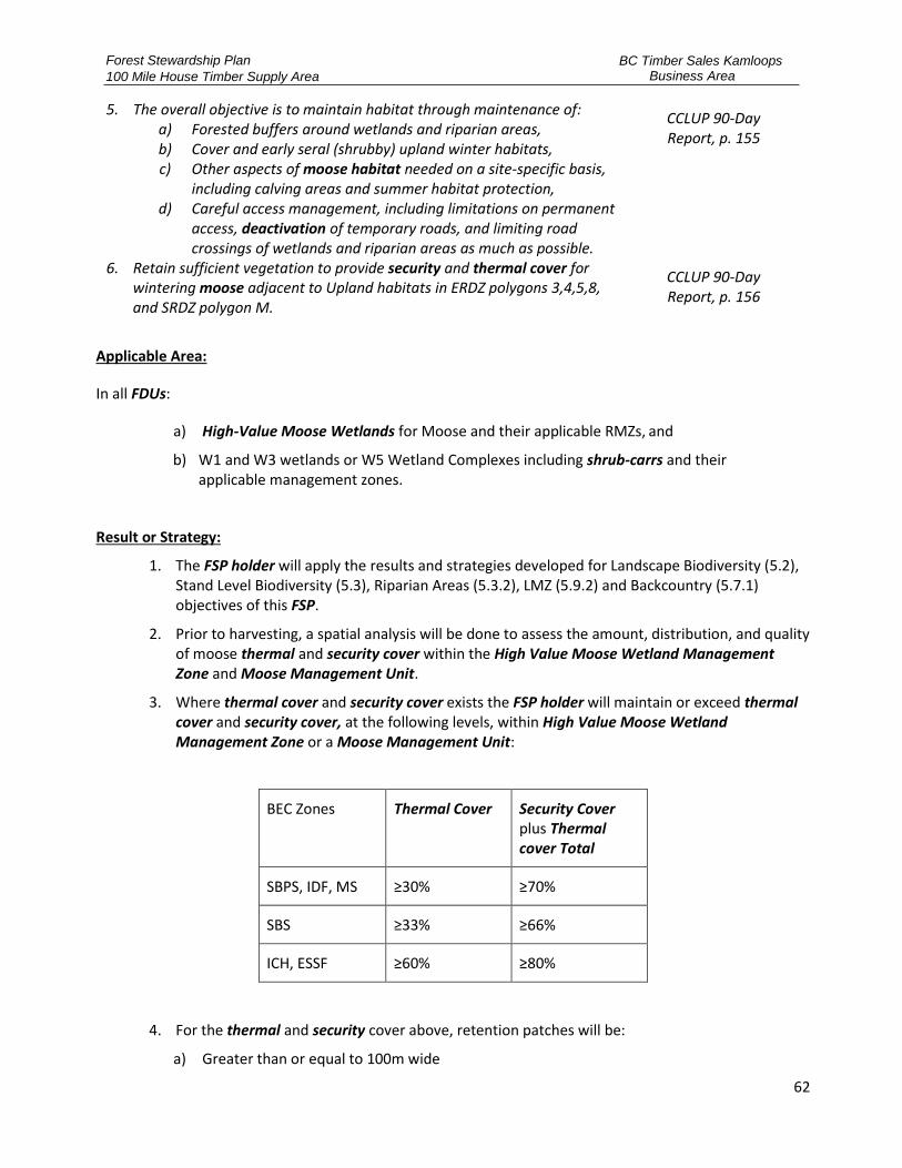
Forest Stewardship Plan
100 Mile House Timber Supply Area
BC Timber Sales Kamloops Business Area
62
5. The overall objective is to maintain habitat through maintenance of: a) Forested buffers around wetlands and riparian areas, b) Cover and early seral (shrubby) upland winter habitats, c) Other aspects of moose habitat needed on a site-specific basis,
including calving areas and summer habitat protection, d) Careful access management, including limitations on permanent
access, deactivation of temporary roads, and limiting road crossings of wetlands and riparian areas as much as possible.
CCLUP 90-Day Report, p. 155
6. Retain sufficient vegetation to provide security and thermal cover for wintering moose adjacent to Upland habitats in ERDZ polygons 3,4,5,8, and SRDZ polygon M.
CCLUP 90-Day Report, p. 156
Applicable Area:
In all FDUs:
a) High-Value Moose Wetlands for Moose and their applicable RMZs, and
b) W1 and W3 wetlands or W5 Wetland Complexes including shrub-carrs and their applicable management zones.
Result or Strategy:
1. The FSP holder will apply the results and strategies developed for Landscape Biodiversity (5.2), Stand Level Biodiversity (5.3), Riparian Areas (5.3.2), LMZ (5.9.2) and Backcountry (5.7.1) objectives of this FSP.
2. Prior to harvesting, a spatial analysis will be done to assess the amount, distribution, and quality of moose thermal and security cover within the High Value Moose Wetland Management Zone and Moose Management Unit.
3. Where thermal cover and security cover exists the FSP holder will maintain or exceed thermal cover and security cover, at the following levels, within High Value Moose Wetland Management Zone or a Moose Management Unit:
BEC Zones Thermal Cover Security Cover plus Thermal cover Total
SBPS, IDF, MS ≥30% ≥70%
SBS ≥33% ≥66%
ICH, ESSF ≥60% ≥80%
4. For the thermal and security cover above, retention patches will be:
a) Greater than or equal to 100m wide
Forest Stewardship Plan
100 Mile House Timber Supply Area
BC Timber Sales Kamloops Business Area
63
b) Greater than 2ha;
c) Not greater than 400m apart where more than one patch is established.
5. If the wetland within a HVMWMZ or Moose Management Unit is less than 6 hectares, then Result 4 above does not apply.
6. Based on the assessment, the QRP will develop recommendations for retaining visual screening at the stand level:
a) For the RMA area within the cutblock of High Value Moose Wetlands or Moose Management Unit.
7. The FSP holder, will incorporate the following:
a) Not constructing new extended use roads between High Value Moose Wetlands that are within 1 km of each other, where practicable.
b) Not constructing any roads within 200m High Value Moose Wetlands or W1, W3, W5 or shrub-carr wetland, where practicable.
c) Maintaining a 10 metre visual screening buffer along 80% of extended use roads within the 1km of High Value Moose Wetland.
d) Installing access control, within 500m of the High Value Moose Wetland and Moose Management Unit, immediately following fibre removal.
e) Installing access control on extended use roads, within 1000m of High Value Moose Wetland, within 5 years following the completion of timber harvesting of the cutblock(s).
8. For the portions of cutblock within 500m (slope distance) of High Value Moose Wetlands or Moose Management Unit, the free growing dwarf mistletoe damage criteria for even-aged coniferous trees as specified in the FS660 field card, will not apply to retained Lodgepole pine and subsequent Lodgepole pine regeneration.
5.5.4.2 Mule Deer
Objective:
1. Maintain mule deer winter range values through modified harvest regimes over the appropriate percentage of the forest polygon by CCLUP subzone.
CCLUP 90-Day Report, p. 60-133
2. Maintain mule deer winter range values in a condition that will support the regional population during critical winter conditions.
CCLUP 90-Day Report, p. 155
Applicable Area:
All FDUs within UWR U-5-003.
Result or Strategy:
1. The FSP holder adopts as a result or strategy the general wildlife measures specified in the GAR orders U-5-003, as this order was on the date the FSP was submitted; and
2. The FSP holder will comply with the results or strategies presented in Riparian Areas (5.3.2), Hydrology (5.4.2), Critical Fish Habitat (5.5.3.1), Biodiversity – Stand Level (5.3), and Visual Quality (5.8) of this FSP.
Forest Stewardship Plan
100 Mile House Timber Supply Area
BC Timber Sales Kamloops Business Area
64
5.5.4.3 Salmon
Objective:
1. Manage the Bonaparte River watershed for salmon stocks (approximately 10 % of the polygon), through riparian area protection and controls on the rate of harvest.
CCLUP 90-Day Report, p. 60-
134
2. Manage the Horsefly River watershed within the Canim FDU for salmon stocks (approximately 35 % of the polygon), through riparian area protection and controls on the rate of harvest.
CCLUP 90-Day Report, p. 120.
3. Manage the Horsefly River watershed within the Boss/Deception FDU for salmon stocks (approximately 90 % of the polygon), through riparian area protection and controls on the rate of harvest.
CCLUP 90-Day Report, p. 60
4. Manage the Bonaparte River tributaries and Fraser River mainstem banks for salmon stocks (approximately 25 % of the polygon), through riparian area protection and controls on rate of harvest.
CCLUP 90-Day Report, p. 78
Applicable Area:
Interlakes, Canim, Boss/Deception, Clinton, Grasslands, and Marble Range FDUs.
Results or Strategies
1. To manage key watersheds for salmon stocks, the FSP holder will apply the result or strategy for Community Watershed (5.4.1), Biodiveristy – Landscape (5.2), Biodiversity – Stand Level (5.3) Hydrology (5.4.2), Fisheries Sensitive Watersheds (5.4.3), Riparian (5.3.2), Critical Fish Habitat (5.5.3.1), and Species at Risk – General (5.5.1.1).
5.5.5 Access Management for Wildlife
Objective:
1. Plan and manage forest development activities so as to avoid, minimize or mitigate impacts to significant commercial and non-commercial values and opportunities that occur in association with forest lands, including wildlife, fish, water, range, recreation and tourism.
CCLUP 90-Day Report P. 68, 179.
Applicable Area:
All FDUs.
Results or Strategies:
1. The FSP holder carries out primary forest activities, and will:
a) Apply the results and strategies for Wildlife (5.5), Backcountry (5.7.1), Moose (5.5.4.1), Grizzly Bear (5.5.2.1), Mule Deer (5.5.4.2), LMZs (5.9.2), and Riparian Areas (5.3.2).
b) Participate in specific access management planning exercises sanctioned by the 100 Mile House Natural Resource District.

Forest Stewardship Plan
100 Mile House Timber Supply Area
BC Timber Sales Kamloops Business Area
65
5.6 CULTURAL HERITAGE RESOURCES
Definitions:
“Affected Cultural Heritage Resource (Affected CHR)” means a CHR to which the objective set by government in section 10 of the FPPR pertains.
“CHR” as defined in the Forest Act Definitions, means an object, a site or the location of a traditional societal practice that is of historical, cultural, or archaeological significance to British Columbia, a community or an aboriginal people.
“CHR Evaluation (CHR Evaluation)” means a process conducted by an authorized member of the affected First Nation or QRP to assess the existence and significance of an affected CHR.
“CHR Mitigation Strategy (CHR Mitigation Strategy)” means a plan to mitigate the direct impact of primary forest activities on a CHR, based on:
• The relative value or importance of a particular CHR to a traditional use by an aboriginal people,
• The relative abundance or scarcity of a CHR that is the focus of a traditional use by an aboriginal people,
• The historical extent of a traditional use by an aboriginal people of a CHR,
• The impact on government granted timber harvesting rights of conserving or protecting a CHR that is the focus of a traditional use by an aboriginal people,
• Options for mitigating the impact that a forest practice might have on a CHR that is the focus of a traditional use by an aboriginal people.
“Information Sharing Summary” means a summary report describing communications with Potentially Affected First Nations, recommendations from CHR Evaluations, and proposed CHR Mitigation Strategy.
“Potentially Affected First Nations” are those First Nations who have identified areas of interest (as defined by the Consultative Areas Database or equivalent government system) that overlap the proposed area where primary forestry activities planned to occur or occur.
Objective:
1. The objective set by government for CHRs is to conserve, or, if necessary, protect CHRs that are the focus of a traditional use by an aboriginal people that is of continuing importance to that people, and not regulated under the Heritage Conservation Act.
FPPR s. 10
Applicable Area:
All FDUs.

Forest Stewardship Plan
100 Mile House Timber Supply Area
BC Timber Sales Kamloops Business Area
66
Result or Strategy:
1. In relation to the objective for CHRs set out in section 10 of the FPPR, where a CHR Evaluation has not been completed on a new cutblock or road, the FSP holder will:
a) Follow any specific or general protocols that are developed and agreed to with Potentially Affected First Nations.
b) In the absence of specific or general protocols, and prior to carrying out or authorizing primary forest activities:
i. The FSP holder will, at minimum 60 days prior to the submission of TSL, CP, or RP, share information regarding the the area of proposed cutblocks and roads with the Potentially Affected First Nations, and request the Potentially Affected First Nations to:
1. Indicate the presence, relative value and abundance of a CHR; and
2. Identify where a CHR Evaluation is recommended; and
ii. Where a Potentially Affected First Nation responds and identifies the need for a CHR Evaluation, ensure a CHR Evaluation is completed; and
iii. Where a CHR Evaluation includes recommendations to mitigate the direct impact of primary forest activities on a CHR, develop a CHR Mitigation Strategy in conjunction with the Potentially Affected First Nation; and
iv. Where a CHR Mitigation Strategy cannot be agreed upon with the Potentially Affected First Nation, the FSP holder will obtain advice from the FLNRORD staff on how to proceed in implementing a CHR Mitigation Strategy.
v. If a specific previously unidentified Potentially Affected CHR is identified during primary forest activities, modify or stop work to the extent necessary to protect the affected CHR.
c) The FSP holder will submit the Information Sharing Summary and mitigation strategy to the appropriate Statutory Decision Maker, prior to issuance of TSL, Cutting Permit or Road permit.
d) The CHR Mitigation Strategy will be shared with the Potentially Affected First Nation who expressed interest the Cultural Heritage Evaluation prior to commencment of primary forestry activities.
e) The FSP holder will implment CHR Mitigation Strategy.
Forest Stewardship Plan
100 Mile House Timber Supply Area
BC Timber Sales Kamloops Business Area
67
5.7 RECREATION AND BACKCOUNTRY
5.7.1 Backcountry
Definitions:
“Backcountry Polygon” means Backcountry recreation areas defined for sub-regional planning and CCLUP planning and analysis.
“Backcountry Operator” means guide outfitters, registered trappers, known clubs or associations who have intrests in maintaining backcountry conditions.
“Key Lakes” are lakes that have visual objectives and other values important to the tourism industry and related recreation opportunities. They can also be classified as one of the lakes identified in LMZs (5.9.2) as Refugium, Wilderness Fisheries, Quality, or General Lakes.
Objective:
1. Maintain percentages of FDUs’ area in a backcountry condition. CCLUP 90- Day
Report, p. 60-134
Applicable Area:
All FDUs.
Result or Strategy:
1. The FSP holder will:
a) Where an access management plan or sub-regional management plan addressing access management has been endorsed by the District Manager, Regional Manager or equivalent, the FSP holder will adhere to the requirements specified in that plan for road density, road use and road location.
2. Where a non-buffered trail (Land Act Order) identified is within the cutblock area, the FSP holder will:
a) Ensure the trail is left free of debris; and
b) Create stub trees along the trail at a distance suitable to mark the location of the trail following harvest, and
c) Not conduct skidding or site preparation on the trail, and
d) Not locate roads on the trail, with excepetions of road crossings
3. Depsite clause 2c), if skidding is required on a trail, skidding will be perpendicular to the trail and only where crossings are required.
4. The FSP Holder will, prior to submission, of the TSL, cutting permit, or road permit, notify backcountry operators, who have an intrest in maintaining the backcountry condition and are potentially affected by the the proposed forestry activities; and provide the parties with a minimum of 60 days to identify any issues or concerns they may have within the vicinity of the

Forest Stewardship Plan
100 Mile House Timber Supply Area
BC Timber Sales Kamloops Business Area
68
proposed forestry activities.
5. Have a QRP prepare a plan to incorporate concerns raised in 1 above, and where practicable, mitigate the impacts of the proposed forestry activities. The FSP holder will share the plan with the applicable backcountry operators to seek agreement.
6. If agreement cannot be reached between the FSP holder and the backcountry operator, conduct a meeting with FLNRORD, FSP holder and the affected backcountry operator to reach an agreement. If agreement is not reached the direction will be the sole discretion of the District Manager and the FSP holder will implement the direction.
5.7.2 Wildcraft
Objective:
1. Maintain level of access to… % of the polygon… and restricting the development of permanent road access over specified targets in the CCLUP.
CCLUP 90- Day Implementation Plan,
p. 153-154
Applicable Area:
All FDUs.
Result or Strategy:
1. Where an access plan has been endorsed by the District Manager, Regional Manager or equivalent, the FSP holder will adhere to the requirements specified in that plan for road density, road use, road location and road duration.
2. 60 days prior to establishing access controls or deactivation that eliminates vehicle access on an existing extended use road, the FSP holder will notify the parties listed below:
a) First Nations whose traditional territory overlaps the location of the proposed access control; and
b) Stakeholders who have the potential to be impacted due to the access control.
3. Have a QRP prepare a plan to incorporate concerns raised in 2 above, and where practicable, mitigate the impacts of the proposed forestry activities. The FSP holder will share the plan with the applicable First Nations and stakeholders to seek agreement.
4. If agreement cannot be reached between the FSP holder and the affected parties, conduct a meeting with FLNRORD, FSP holder and the affected parties to reach an agreement. If agreement is not reached the direction will be the sole discretion of the District Manager and the FSP holder will implement the direction.
5. When primary forest activities are conducted, the FSP holder will:
a) Apply the results and strategies for Backcountry (5.7.1), Access Management for Wildlife (5.5.5), and Tourism – General (5.9.1).
6. The FSP holder will participate in specific access management planning exercises sanctioned by the 100 Mile House Natural Resource District and implement their direction.

Forest Stewardship Plan
100 Mile House Timber Supply Area
BC Timber Sales Kamloops Business Area
69
5.7.3 Recreation Sites, Trails and Interpretive Forests
Definitions:
“Recreation Sites, Recreation Trails” and “Interpretive Forests” are areas of Crown land within or outside of Provincial Forests that area established by the Minister under section 56 (1) of the FRPA [or previously under section 6(1) of the FPC] for managing their recreation values.
“Objective” means, within the applicable FDU, the legally established objective(s) for Recreation Sites and Trails within the 100 Mile House Natural Resource District.
Objective:
1. Manage established recreation sites, trails and interpretive forests in accordance with established objectives26.
FPPR s. 181
Applicable Area:
All FDUs.
Result or Strategy:
1. Prior to carrying out harvesting of a cutblock or construction of a road within 100 m (slope distance) of designated Recreation Sites, Trails or Interpretive Forest shown in Appendix D – Objectives for Recreation Sites, Trails and Interpretive Forest Sites, the FSP holder will:
a) Refer, 60 days prior to the proposed activity, to the Ministry responsible for recreation, requesting input on the proposal as it relates to the established objective, and
b) Where the Ministry representative responsible for recreation provides input on the activity, develop a management strategy that incorporates the input into the development of harvesting and road construction to the extent practicable, and
c) Communicate the management strategy to the Ministry responsible for recreation, and
d) Carry out harvesting and road construction consistent the management strategy.
2. When the FSP holder retains maintenance responsibility for a Forest Service Road that is the only access to an established Recreation Site or Trail, the FSP holder will ensure that summer access is not restricted except for temporary closures to repair or replace roads and stream crossings.
3. Within backcountry areas identified in Appendix B – FSP Maps, and Appendix D – Objectives for Recreation Sites, Trails and Interpretive Forest Sites of this FSP, for those recreation features not listed in Appendix D – Objectives for Recreation Sites, Trails and Interpretive Forest Sites of this FSP, where trails are made known or identified, the FSP holder will, in consultation with those persons who brought the trail to the attention of the FSP holder:
a) Maintain the integrity and location of the identified trails through practices that include
26 Interpretive forest sites, recreation sites and recreation trails that were legally designated under FPC have been continued under FRPA section 180. Where objectives for these interpretive forest sites, recreation sites and recreation trails were legally established under FPC, the objectives have been continued under FRPA 181.

Forest Stewardship Plan
100 Mile House Timber Supply Area
BC Timber Sales Kamloops Business Area
70
but are not limited to:
i. No-harvest buffer zones,
ii. Basal area retention or stubbing adjacent to trails,
iii. Not locating roads on trails,
iv. Crossing trails at right angles to extent practicable,
v. Not use trails as skid trails.
5.7.4 Buffered Trails
Definitions:
“Blowdown” means a tree or trees uprooted or blown over by the wind or other natural process.
“Buffered Trails” are trails that have been identified in Objective 30 of the CCLUP LUO Map 10 “Buffered Trails in SRMP Areas”.
Objective:
1. For buffered trails shown on LUO map 10, maintain 50 meter management zones on either side, with the treed area inside the management zone managed to the combined minimum basal area retention of 85% except where roads cross trails.
CCLUP LUO 30
2. Despite CCLUP LUO Objective 30, primary forest activities that remove more than 15% of the basal area within the management zones are permitted for any of the following reasons:
a) Where harvesting is essential for insect control to curtail severe damage to forest values at the landscape level in a BMU classified as suppression for that insect pest,
b) Where harvesting is necessary to manage for blowdown where that helps to maintain the recreational value of the trail.
CCLUP LUO 31
Applicable Area:
All FDUs.
Result or Strategy:
1. For buffered trails shown on CCLUP LUO Map 10 “Buffered Trails in SRMP Areas”, the FSP holder, when carrying out or authorizing primary forest activities, will maintain a management zone of greater than or equal to 50 m on either side of the trail, where it exists, with the treed area inside the trail management zone having a minimum basal area retention of 85%, except where roads cross trails.
2. Despite strategy (1), primary forest activities that remove more than 15% of the basal area within the management zones are conducted for any of the following reasons:
a) Where harvesting is essential for insect control,
b) Where harvesting is necessary to:

Forest Stewardship Plan
100 Mile House Timber Supply Area
BC Timber Sales Kamloops Business Area
71
i. Recover blowdown that has impacted the trail
ii. Recover trees that have been damaged by fire, insect or disease, and could blowdown on the trail.
c) The FSP holder will protect green trees in the management zone to the extent practicable.
d) Within primary and interface fuel breaks, in an approved community or regional wildfire plan, maintain the recreational value of the trail during the:
i. reduction of fine surface debris, ladder fuels and small diameter trees in intermediate and overtopped crown classes, and
ii. separation of tree crowns among individual trees or clumps within the dominant and co-dominant layers sufficient to mitigate the spread of a passive crown fire, to a maximum spacing of 6 metres between crowns.
e) Within a designated Wildfire Urban Interface area, reduction of fine surface debris, dead trees, ladder fuels and small diameter trees in intermediate and overtopped crown classes.
5.8 VISUAL QUALITY
Definitions:
“Alteration” means changing or making something different as a result of conducting harvesting or road construction by the FSP holder.
“Scenic Area” means an area that is deemed visually important based on its physical characteristics and public use, and that requires special management. Scenic areas are shown on CCLUP Map 9a and defined by the spatial dataset “Cariboo-Chilcotin Scenic Areas”
“Severly burnt scenic areas” means a portion of scenic areas that are visible from the applicable viewpoints that have >75% of the trees with >75% crown mortality (>75% brown needles or no needles) from scorch.
“Viewpoints” means one or more of the following where accessible by the public:
a) Lake surfaces for a scenic area associated with a lake,
b) River channel for a scenic area associated with a river,
c) Existing tourism facitlities and key tourist use areas,
d) Existing tourism operators as defines in Tourism (5.9.1)
e) Points of highways and other viewpoints deemed significant by a QRP.
“Visual Quality Objectives (VQOs)” means the applicable category of Visual Quality described in FPPR s. 1.1 Categories of Visually Altered Forest Landscapes
Forest Stewardship Plan
100 Mile House Timber Supply Area
BC Timber Sales Kamloops Business Area
72
Objective:
1. Maintain the visual quality objectives (VQOs) for scenic areas as shown on map 9a and defined by the spatial dataset, Cariboo-Chilcotin Scenic Areas.
CCLUP LUO 26
2. Despite objective 1, harvesting is permitted where it is essential for insect control to curtail severe damage to forest values at the landscape level in a BMU classified as suppression for that insect pest.
CCLUP LUO 27
3. Along the scenic corridors shown on map 9b and defined by the spatial dataset, Cariboo- Chilcotin Scenic Corridors, design harvest areas to mimic existing natural openings, vegetation patterns and natural features.
CCLUP LUO 28
4. Design harvest areas to mimic existing natural openings, vegetation patterns, and natural features when viewed from the high elevation viewpoints shown on map 9c and defined by the spatial dataset, Cariboo-Chilcotin High Elevation Viewpoints.
CCLUP LUO 29
Applicable Area:
All FDUs.
Result or Strategy:
1. Where the FSP holder carries out or authorizes primary forest activities in Scenic Areas shown on CCLUP Map 9a and defined by the spatial dataset “Cariboo-Chilcotin Scenic Areas”:
a) the visual alteration resulting from cutblock harvesting and road construction is consistent with:
i. CCLUP LUOs 26 to 29, and
ii. The Visual Quality Objective identified in the CCLUP Spatial dataset 9
iii. The results or strategies for objectives defined in LMZs (5.9.2) of this FSP, and
iv. The applicable category of Visual Quality described in FPPR s. 1.1 Categories of Visually Altered Forest Landscapes, and
2. Despite clause 1 above, the extent of the alteration resulting from the size, shape and location of cutblocks and roads can be exceeded, provided that:
a) Harvesting is essential for insect control and all identified infestation sites within 500m of the infested scenic area is addressed prior to or in conjunction with harvest entires into scenic areas; or
b) Within retention and preservation polygons primary and interface fuel breaks, in an approved community or regional wildfire plan where impacts to Visual Quality Objectives are minimized:
i. reduction of fine surface debris, ladder fuels and small diameter trees in intermediate and overtopped crown classes.
c) For primary and interface fuel breaks located in partial retention and modification polygons that are in an approved community or regional wildfire plan and require impacts to Visual Quality Objectives are minimized:

Forest Stewardship Plan
100 Mile House Timber Supply Area
BC Timber Sales Kamloops Business Area
73
i. reduction of fine surface debris, ladder fuels and small diameter trees in intermediate and overtopped crown classes; and
ii. separation of tree crowns among individual trees or clumps within the dominant and co-dominant layers sufficient to mitigate the spread of a passive crown fire, to a maximum spacing of 6 metres between crowns.
d) Within a designated Wildfire Urban Interface area, reduction of fine surface debris, windthrown trees, ladder fuels and small diameter trees in intermediate and overtopped crown classes.
3. Where the FSP holder carries out or authorizes primary forest activities in Scenic Corridors shown on CCLUP Map 9b and defined by the spatial datasets “Cariboo-Chilcotin Scenic Corridors”, then
a) The resulting design prepared by a QRP, harvesting, and road construction, mimic the:
i. Existing natural openings, ii. Vegetation patterns; and iii. Natural features.
4. Where the FSP holder carries out or authorizes primary forest activities in Areas visible from High Elevation Viewpoints as shown on CCLUP Map 9c and defined by the spatial dataset “Cariboo-Chilcotin High Elevation Viewpoints”, then
a) The resulting design prepared by a QRP, harvesting, and road construction, mimic the:
i. Existing natural openings,
ii. Vegetation patterns; and
iii. Natural openings.
5. Despite clause 1 above, in severly burnt scenic areas where salavage harvesting will exceed the alteration allowed for under the established VQOs for partial retention and modification, the FSP holder will:
a) Have a QRP conduct a visual impact assessment which includes a description of the visual design measures used to mitigate visual impacts;
b) Adhere to the results or strategies presented in Tourism (5.9.1) and Recreation and Backcountry (e), Wildcraft (5.7.2), Recreation Sites, Trails and Interpretive Forests (5.7.3), and Buffered Trails (5.7.4).
c) Design harvest openings to mimic natural shapes and openings, and not use rectilinear or geometric edges in the design.
d) Develop a reforestation plan that demonstrates that exceeding the VQO will result in a net benifit to visual green-up recovery;
e) Retain green healthy trees where practicable;
f) Where practicable;
i. Utilize multiple smaller openings
ii. Expedite rehabilitation of the visual alteration from roads visible from view points
iii. Describe the retention within the cutblock boundaries
iv. Consider and incorporate input recieved from public consultation conducted in
Forest Stewardship Plan
100 Mile House Timber Supply Area
BC Timber Sales Kamloops Business Area
74
clause 5b) above.
5.9 TOURISM
5.9.1 Tourism – General
Definitions:
“Tourism Operator” means owners of known tourism operations (example lodges, resorts, commercial campsites) and licensed users of crown land for recreation and tourism purposes, and guide outfitters.
Objective:
1. Plan and manage forest development activities so as to avoid, minimize or mitigate impacts to significant commercial and non-commercial values and opportunities that occur in association with forest lands, including wildlife, fish, water, range, recreation, and tourism.
CCLUP 90-Day Report, p. 68,
179
2. Maintain the visual quality in the viewshed surrounding existing tourism operations.
CCLUP 90-Day Report
3. Incorporate tourism needs for high quality environments, including: a) Tranquil Settings – Forest operations in the mid and especially the
backcountry should be conducted outside of peak tourism season, to reduce the impact of noise.
b) Scenic Quality – Forest operations should either avoid or minimize impacts on scenic quality. Any impacts that do occur must be rehabilitated within a specified time period.
c) Air Visibility Quality – Smoke generation (through slash burning, etc.) should not impact tourism areas during the peak tourism season.
d) Setting Diversity – Alternative silvicultural and harvesting systems should be employed to provide for a variety of forest settings.
e) Controlled Access – access management planning should precede operations in order to incorporate tourism industry needs.
CCLUP 90-Day Report, p. 140-
141
Applicable Area:
All FDUs.
Result or Strategy:
1. To reduce or minimize impacts on tranquil settings and scenic quality, the FSP holder will adhere to the results or strategies presented in Visual Quality (5.8), LMZs (5.9.2) and Recreation and Backcountry (5.7.1) of this FSP.
2. To reduce the impact on tourism from air visibility quality, the FSP holder will ensure the implementation of the current practice requirements and/or regulations regarding open burning and air quality.
3. To incorporate tourism industry needs into access management planning, the FSP holder will
Forest Stewardship Plan
100 Mile House Timber Supply Area
BC Timber Sales Kamloops Business Area
75
adhere to the results or strategies presented in the Backcountry (5.7.1) section of this FSP.
4. 60 days prior to carrying out or authorizing primary forest activities, the FSP holder will gather input from potentially affected parties, including but not limited to known tourism operators within 2kms of proposed cutblocks and roads.
5. Have a QRP prepare a plan to incorporate concerns raised in 4 above, and where practicable, mitigate the impacts of the proposed forestry activities. The FSP holder will share the plan with the applicable tourism operator to seek agreement.
6. If agreement cannot be reached between the FSP holder and the tourism operator, conduct a meeting with FLNRORD, FSP holder and the affected tourism operator to reach an agreement. If agreement is not reached the direction will be the sole discretion of the District Manager and the FSP holder will implement the direction.
7. The FSP holder will make its known timber development plans accessible to the public using an Internet Based Platform.
5.9.2 Lakeshore Management Zoness
Definitions:
“General Lake” as defined in Schedule 3 Lakeshore Management Classes (CCLUP LUO ), these lakes provide public recreation in a predominantly rural or natural setting. Road access is generally good (2-wheel drive). Land development is variable and the natural environment may be substantially modified.
“LMZ (LMZ)” means a management zone of a specified width adjacent to a classified lake as identified on Appendix B – FSP Maps. LMZ characteristics are determined by the possible mix of activities, settings, ecological attributes and probable experience opportunities.
“Quality Lake” as defined in Schedule 3 Lakeshore Management Classes (CCLUP LUO), these lakes provide quality natural features with pristine surroundings and natural appearing environment. Road access and land development is minimized.
“Refugium Lake” as defined in Schedule 3 Lakeshore Management Classes (CCLUP LUO), are ecologically unique or important for ecosystem representation and contain rare or endangered species or habitats, have unique ecological or physiographic associations (e.g. karst formations). The area around the lake is managed to conserve the special ecological or physiographic feature or habitats.
“Wilderness Fisheries Lake” as defined in Schedule 3 Lakeshore Management Classes (CCLUP LUO) provides natural features in undisturbed wilderness setting.
Objective:
1. For the LMZs shown on map 6a and defined by the spatial dataset “Cariboo-Chilcotin Lake Management Classes”, manage the lakes in accordance with schedule 2.
CCLUP LUO 16
2. For the lakes shown on map 6b and defined by the spatial dataset “Cariboo-Chilcotin Lake Management Classes”, manage to the lakes in accordance with schedule 3.
CCLUP LUO 17
3. Despite objectives 1 and 2, variance from the VQOs and the maximum disturbance limits in schedule 2 and the lake management intent in schedule 3 is permitted in LMZs for any of the following reasons:
CCLUP LUO 18

Forest Stewardship Plan
100 Mile House Timber Supply Area
BC Timber Sales Kamloops Business Area
76
a) Where harvesting is essential for insect control to curtail severe damage to forest values at the landscape level in a BMU classified as suppression for that insect pest,
b) Road and fence construction in Class A lakeshore management classes where there is no other practicable location available, and,
c) Reduction of fine surface debris, ladder fuels and small diameter trees in intermediate and overtopped crown classes within Interface Fire Management Plan Areas, where that does not diminish old growth characteristics.
4. For Refugia and wilderness fisheries lakes, locate new roads away from the lakeshore, sufficient to protect the existing character of the lake, unless no other practicable route exists.
CCLUP LUO 19
Applicable Area:
LMZs shown on CCLUP Map 6a and 6b, and defined by the spatial dataset “Cariboo-Chilcotin Lakeshore Management Classes”.
Result or Strategy:
1. For lakes with an established Lakeshore Management Class, shown on CCLUP Map 6a and 6b and as defined by the spatial dataset “Cariboo- Chilcotin Lakeshore Classes”, the FSP holder will conduct primary forest activities according to the following:
a) Specific to General Lakes:
i. With an established LMZ, achieve the VQO by lakeshore management class listed in Table 14 within the LMZ; or
ii. Without an established LMZ, achieve a VQO of partial retention within 200m of the lakeshore.
b) Specific to Quality Lakes:
i. Where practicable locate new roads outside the LMZ and achieve the VQO, by LMZ class listed in Table 14, within the LMZ.
c) Specific to Refugium Lakes:
i. The LMZ will be a no-harvest area, or
ii. For refugium lakes without a LMZ; the area within 200m of the lake will be a no-harvest area.
d) Specific to Wilderness Fisheries Lakes;
i. Achieve VQO of preservation within the LMZ, and
ii. Where practicable, not construct or upgrade roads within 2km of the lakeshore; or
iii. Where new roads are constructed within 2km of the lakeshore, install access controls at the beginning of the road, or at a minimum distance of 2kms from the lakeshore following delivery of fibre from the cutblock.

Forest Stewardship Plan
100 Mile House Timber Supply Area
BC Timber Sales Kamloops Business Area
77
2. Despite strategies (1) through (4), variance from the maximum disturbance limits and VQOs in Table 14 is permitted in LMZs for any of the following circumstances:
a) Road and fence construction in Class A Lakeshore Management Classes where there is no other practicable location available, or
b) Where harvesting is essential for insect control, or
c) Thinning-from-below to enhance old seral forest attributes in LMZs located within designated MDWR in the shallow and moderate snowpack zones, or
d) Within primary and interface fuel breaks, in an approved community or regional wildfire plan, where impacts to LMZ characteristics are minimized:
i. reduction of fine surface debris, ladder fuels and small diameter trees in intermediate and overtopped crown classes and,
ii. separation of tree crowns among individual trees or clumps within the dominant and co-dominant layers sufficient to mitigate the spread of a passive crown fire, to a maximum spacing of 6 metres between crowns.
e) To conserve deciduous patches, significant wildlife trees, major wildlife features, and moist under-story habitats within all LMZs and VQOs within LMZs, the FSP holder will apply the results or strategies for Riparian Areas (5.3.2) of this FSP.
Table 14 - Lakeshore Management Classes (CCLUP LUO Schedule 2)
Lakeshore Management Classes
Visual Quality Objective in the LMZ
Forest Disturbances and Retention in the LMZ
All Conserve deciduous patches, significant wildlife trees, non-merchantable timber, major wildlife features, and moist under-story habitats
Partial Cutting Clearcutting
A Preservation No harvest
B Retention
≤20% of the LMZ, area harvested, every 20 years with a minimum basal area retention of ≥50%
Maximum disturbed area is ≤10% of the LMZ every 20 years with openings smaller than 5 ha.
C Partial Retention
≤40% of the LMZ, area harvested, every 20 years with a minimum basal area retention of ≥50%
Maximum disturbed area is ≤20% of the LMZ every 20 years with openings smaller than 10 ha.
D Modification
≤60% of the LMZ, area harvested, every 20 years with a minimum basal area retention of ≥50%
Maximum disturbed area is ≤30% of the LMZ every 20 years. Retain a minimum of 25% of the basal area in the LMZ where practicable.
E Modification
≤100% of the LMZ, area harvested, every 20 years with a minimum basal area retention of ≥50% in the LMZ
Maximum disturbed area is ≤50% of the LMZ every 20 years. Retain a minimum of 25% of the basal area in the LMZ where practicable.

Forest Stewardship Plan
100 Mile House Timber Supply Area
BC Timber Sales Kamloops Business Area
78
5.10 RANGE AND GRAZING
5.10.1 Natural Range Barriers
Definitions:
“Natural Range Barrier” means a river, a rock face, dense timber, or other naturally occurring feature that stops or significantly impedes livestock movement to and from an adjacent area.
“Range Mitigation Strategy” means a plan developed to mitigate impacts to range operations, infrastructure, or natural range barriers: that specifies:
a) What Mitigation Actions are to be undertaken,
b) Who is responsible for undertaking the Mitigation Actions,
c) Where the Mitigation Actions will occur, and
d) When the Mitigation Actions will be completed.
Objectives:
1. Plan and manage forest development activities so as to avoid, minimize or mitigate impacts to significant other commercial and non-commercial values and opportunities that occur in association with forest lands, including wildlife, fish, water, range, recreation and tourism.
CCLUP 90-Day Report, p. 68,
179
Applicable Area:
All FDUs.
Result and Strategies:
1. In relation to the objectives set by government to mitigate the effect of removing or rendering ineffective Natural Range Barriers and minizing impacts to Range Tenure Holders, the FSP holder will:
a) At a minimum of 60 days prior to the authorizing or conducting harvesting and road construction, will share information regarding the location of the proposed cutblocks and/or roads with the Range Tenure Holders whose tenure area is within or adjacent to (500 m) of the proposed development. The referral will:
i. Specify the location of the proposed harvesting and road construction; and
ii. Request that the range agreement holder identify the location of Natural Range Barriers that may be rendered ineffective by the proposed harvesting or road construction;
iii. Request that Range Tenure Holder identify any impacts to range operations and infrastructure, and
b) Prior to authorizing or conducting harvesting a cutblock or constructing a road:
i. Where the range agreement holder responds within the timelines specified in the referral, and identifies Natural Range Barriers and other impacts to their tenure

Forest Stewardship Plan
100 Mile House Timber Supply Area
BC Timber Sales Kamloops Business Area
79
that will be removed or rendered ineffective, develop a Range Mitigation Strategy, incorporating the information communicated by the range agreement holder to the extent that it is practicable to do so; and
ii. Where there is knowledge of a Natural Range Barriers, and where the Range Agreement Holder fails to respond to the referral, advise the FLNRORD District Range Staff; and
iii. Communicate the Range Mitigation Strategy to the Range Agreement Holder; and
iv. Where new harvesting or road construction is proposed in an area where Range Tenure is not currently assigned, refer the proposal to the FLNRORD District Range Staff 60 days prior authorizing or conducting primary forestry activities; and
v. Where the Ministry responsible for Range responds within the timelines specified in the referral and identifies that a Natural Range Barriers will be removed or rendered ineffective, develop a Range Mitigation Strategy, incorporating the information communicated by the FLNRORD District Range Staff; and
vi. Conduct activities that are the responsibility of the FSP holder consistent with the Range Mitigation Strategy.
2. If agreement cannot be reached between the FSP holder and the Range Tenure Holder, conduct a meeting with FLNRORD, FSP holderand the affected Range Tenure Holder to reach an agreement. If agreement is not reached the direction will be the sole discretion of the District Manager and the FSP holder will implement the direction.
5.10.2 Animal Unit Months
Definitions:
“Animal unit month (AUM)” as defined by the Range Act, means 450 kg of forage, measured on a dry matter basis, being the amount of forage that would sustain:
a) for one month, an average cow of the genus bos with an unweaned calf born in the current calendar year, or
b) for a period longer or shorter than one month, an animal within a class or species of animal descried in the definition of “livestock”, depending on the type of animal, its stage of development, or both.
Objective:
1. Maintain the current authorized level of AUMs in the polygon and maintain the existing proportion of AUMs by Range Unit.
CCLUP 90-Day Report, p. 60-
134
Applicable Area:
All FDUs.

Forest Stewardship Plan
100 Mile House Timber Supply Area
BC Timber Sales Kamloops Business Area
80
Result and Strategies:
1. Where made known to the FSP holder, by the grazing tenure holder or FLNRORD District Range staff, and confirmed by a QRP, that one or more of the following conditions are present:
a) The designated AUM level as of February 15, 1995 for the AUM polygon is unsustainable or unachievable as a direct result of the primary forest activities conducted by a FSP holder, or
b) The proportion of AUMs by range unit within the polygon, as per the February 15, 1995 availability of AUMs, has changed significantly and that AUM availability in one or more range units within the polygon is decreasing as a direct result of primary forest activities by a FSP holder,
2. The FSP holder, conducting primary forest activities within the identified range unit(s), will enter into consultation with the affected range tenure holders and develop a Range Mitigation Strategy with the intent of modifying harvesting and silviculture practices to, maintain or not further reduce the AUM levels by FDU and range unit, as shown in Table 15.
Table 15 - Authorized Level of AUM’s by FDU (CCLUP 90-Day Report)
FDU AUM’s FDU AUM’s
Boss/ Deception 150 Clinton 5,890
Flat Lake 1,866 Canim 3,055
Interlakes 17,559 Rail 6,629
Lang Lake/ Schoolhouse 265 Gustafson 37,538
Marble Range 4,363 Loon 9,636
Grassland 39,579 Bonaparte 15,900
5.11 INVASIVE PLANTS
Definitions:
“Containment Line” is a delineation of a polygon of an invasive plant infestation indicating large or extensive infestations within the polygon. Inside the containment line the infestation of the invasive plant species is extensive and it is not possible to eradicate the target species. Outside the line the infestation is limited and preventing spread and achieving a long-term goal of eradication is possible.
“Invasive Plant Species” means those plants defined in the Invasive Plants Regulation (January 31, 2004) as amended from time to time.
“Invasive Plant Zone” means the zone as determined by the FSP holder, and updated on an annual basis, designed to encompass, and buffer by 500 m, the known locations of Invasive Plants contained in the Invasive Plant Regulation. The known locations are those identified in the Invasive Alien Plant Program maintained by the provincial government.
“High Priority Invasive Plants” means the following plants: Baby’s Breath, Blueweed, Burdock, Canada Thistle, Common Tansy, Dalmatian Toadflax, Field Scabious, Himalayan Balsam, Hoary Alyssum, Hoary Cress, Hound’s-Tongue, Knotweeds (Polygonum spp.), Marsh Plume Thistle, Mountain Bluet, Orange Hawkweed, Oxeye Daisy, Perennial Pepperweed, Purple Loosestrife, Scentless Chamomile, Spotted & Diffuse Knapweed, Spurges (Leafy, Myrtle, Cypress), St. John’s Wort, Sulphur Cinquefoil, Tansy Ragwort,

Forest Stewardship Plan
100 Mile House Timber Supply Area
BC Timber Sales Kamloops Business Area
81
Wild Chervil and Yellow Flag Iris27.
“Personnel” means persons working on behalf of the FSP holder conducting activities such as road and cutblock development, site plan data collection, road and logging supervision, and silviculture surveys.
“Seed or Forage Mixture” means a seed mixture, that meets Canada Common Number 1 standard (described in the Canada Seed Act and Regulation) as follows:
Species Seed Mix by %
Composition* Annual Ryegrass 46 Slender Wheatgrass 18 Firkin Italian Ryegrass 23 Blue Wildrye 5 Red Clover 7
* Forest recovery mix suitable for all BECs in 100 Mile House TSA Objective:
1. For the purpose of section 47 [invasive plants] of the FRPA, a person who prepares a FSP must specify measures in the plan to prevent the introduction or spread of species of plants that are invasive plants under the Invasive Plants Regulation, if the introduction or spread is likely to be the result of the person's forest practices.
FRPA s. 47
FPPR s. 17
FRPA Invasive Plants Regulation
Applicable Area:
All FDUs.
Results or Strategies:
1. Annually, the FSP holder will consult the Invasive Alien Plant Program (IAPP28) Application to determine known invasive plant sites.
2. The FSP holder will provide training to personnel on reporting and identification of the High Priority Invasive Plants and methods of reducing the spreading weeds, including but not limited to:
a) Removing observed plant material, or significant accumulations of soil containing plant material, from machinery, prior to relocating the machinery outside the cutblock or road.
b) Avoiding infested sites for staging, parking, and log sorting areas,
c) Commence Primary Forestry Activities in uninfested sites before moving to areas with known invasive plants.
d) Stripping overburden off gravel pits – in known invasive plant areas prior to shipping
27 http://cccipc.ca/index.php/cariboo-chilcotin/priority-species/ 28 https://maps.gov.bc.ca/ess/hm/iapp/
Forest Stewardship Plan
100 Mile House Timber Supply Area
BC Timber Sales Kamloops Business Area
82
gravel from the pit.
3. The FSP holder will ensure that a previously unidentified High Priority Invasive Plant infestation within FDUs, as identified by personnel, is reported through the Report-A-Weed app (www.gov.bc.ca/invasive-species) within 30 days of the FSP holder becoming aware of the new infestation.
4. If the FSP holder carries out or authorizes Primary Forestry Activities that will result in creating contiguous areas of disturbed soil ≥0.1 ha, the FSP holder will ensure that within one year of the activity completion, the portions of area occupied by ditch-lines, cut or fill slopes, bladed skid trail, and deactivated roads which area not reforested, are seeded using a seed or forage mixture.
5. A FSP holder will seed with a seed or forage mixture that meets or exceeds Canada Common Number 1 Forage Mixtures as defined by the Canada Seeds Act and Regulation or native shrubs:
a) At least 90% of the total area exposed in a calendar year that requires seeding, by July 1 of the immediately following calendar year; and
b) The remainder of such exposed area prior to December 31 of the same immediately following calendar year; and
6. The Certificate of Seed Analysis must be made available to FLNRORD staff, for review upon request, for a one year period following the application of the seed to ensure that the batch does not contain High Priority Invasive Species.
7. If within an Invasive Plant Zone, where within 12 months of the grass seeding identified in strategy (5) above, it is identified during road inspections that the area is in insufficiently revegetated (less than 10% cover), then the exposed area will be re-seeded at least once in addition to the seeding identified in section (5) above.
6 Stocking Standards
6.1 GENERAL DISCUSSION
1. All stocking requirements are applicable across the entire FSP area (all FDUs).
2. Scale of measurement for stocking standards: FPPR s. 44 will apply to all areas harvested under the authority of this FSP.
3. Where the FSP holder is required under FRPA to establish a free growing stand with respect to timber harvesting governed by this FSP, the FSP holder will do so in accordance with the stocking standards in Appendix A.
4. Table 16 - Single Layer Stocking Standards and Table 17 - Multi - Layer Stocking Standards are derived from the Cariboo Regional Stocking Standards (CRSS), approved July 24, 2018.
5. The original CRSS was modified for this FSP to reflect only the BEC zones within the 100 Mile House Forest District.
6. The Cariboo Regional Stocking Standards Supporting Document, approved July 24, 2018, is included as APPENDIX A- “General Standards and Variations from General Standards”.
6.2 MINIMUM INTER-TREE DISTANCE (MITD)
Despite the distances specified in the stocking standards tables, the MITD may be reduced on hydric and

Forest Stewardship Plan
100 Mile House Timber Supply Area
BC Timber Sales Kamloops Business Area
83
subhydric sites to allow for micro-site selection. The MITD can be reduced on mechanically site prepared sites where target planting density is at least 20% greater than target stocking standards.
6.3 UNEVEN-AGED STOCKING STANDARDS
Uneven-aged stocking standards will apply in circumstances where the forest professional or QRP preparing site specific plans for individual blocks determines that uneven-aged management is the preferred approach to manage the stand.
6.4 REGENERATION DELAY
Regeneration delay will be 4 years unless the site plan identifies natural regeneration for the block or standards unit, then regeneration delay will be set up to a maximum of 7 years.
6.5 DAMAGE CRITERIA
BCTS will use damage criteria for regeneration and free growing surveys specified in FS 660, 2016 Silviculture Surveys Procedures Manual or equivalent future guidelines.
6.6 CROP VS. COMPETITION RATIO
Crop versus competition ratio will be followed as per Appendix A – Stocking Standards.
6.7 MAXIMUM DENSITY
Maximum density will be followed as per Appendix A – Stocking Standards.
6.8 BROADLEAF SPECIES AND MIXED STANDS
Broadleaf species will be utilized in stocking standards for mixed stands. The only commercially acceptable broadleaf species will be aspen. Mixed stand management must only occur on sites where aspen is shown as a productive, reliable and feasible regeneration option. The post-harvest regenerated conifer composition must be representative of the pre-harvest stand composition.
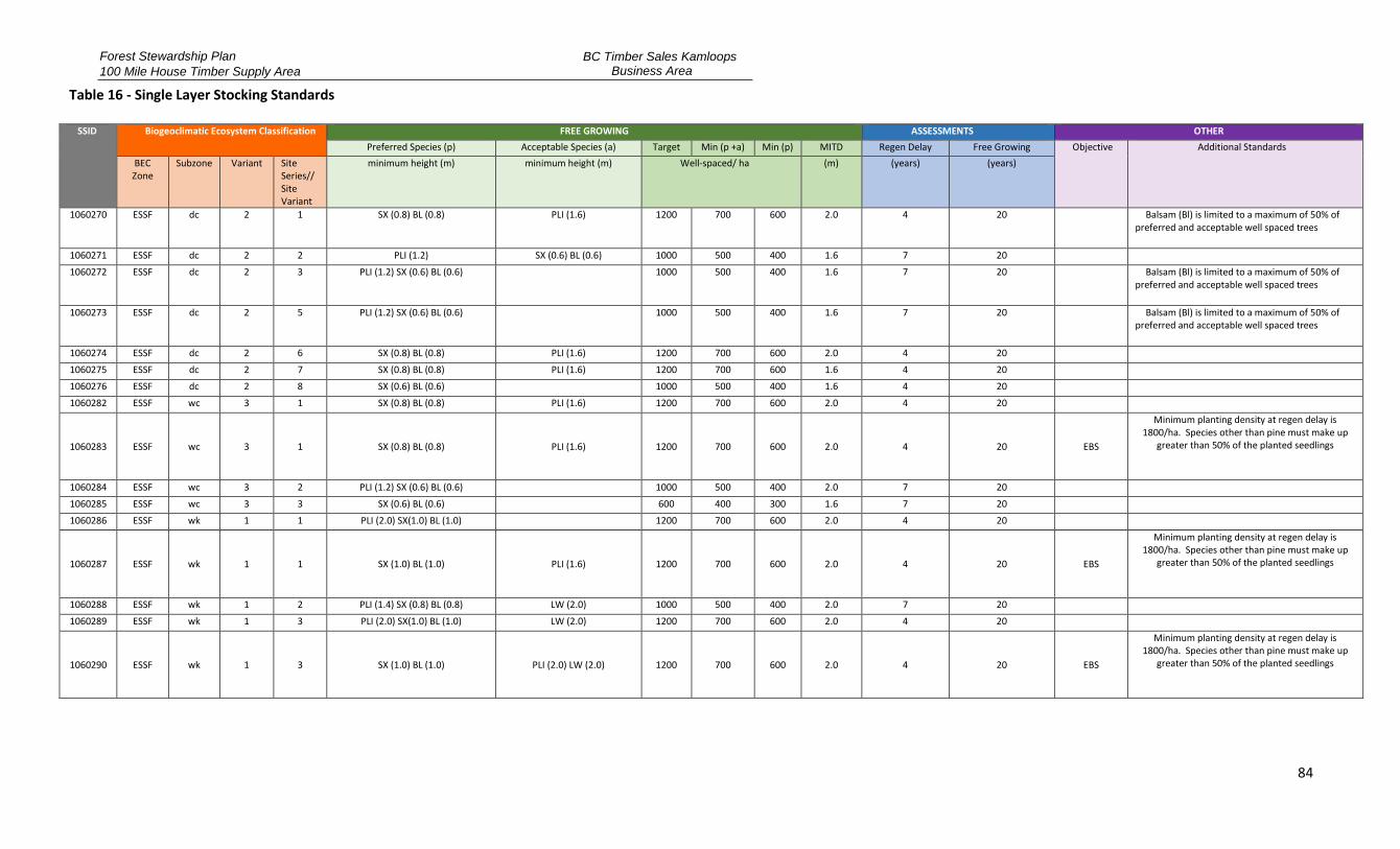
Forest Stewardship Plan
100 Mile House Timber Supply Area
BC Timber Sales Kamloops Business Area
84
Table 16 - Single Layer Stocking Standards
SSID Biogeoclimatic Ecosystem Classification FREE GROWING ASSESSMENTS OTHER
Preferred Species (p) Acceptable Species (a) Target Min (p +a) Min (p) MITD Regen Delay Free Growing Objective Additional Standards
BEC Zone
Subzone Variant Site Series// Site Variant
minimum height (m) minimum height (m) Well-spaced/ ha (m) (years) (years)
1060270 ESSF dc 2 1 SX (0.8) BL (0.8) PLI (1.6) 1200 700 600 2.0 4 20 Balsam (Bl) is limited to a maximum of 50% of preferred and acceptable well spaced trees
1060271 ESSF dc 2 2 PLI (1.2) SX (0.6) BL (0.6) 1000 500 400 1.6 7 20 1060272 ESSF dc 2 3 PLI (1.2) SX (0.6) BL (0.6) 1000 500 400 1.6 7 20 Balsam (Bl) is limited to a maximum of 50% of
preferred and acceptable well spaced trees
1060273 ESSF dc 2 5 PLI (1.2) SX (0.6) BL (0.6) 1000 500 400 1.6 7 20 Balsam (Bl) is limited to a maximum of 50% of preferred and acceptable well spaced trees
1060274 ESSF dc 2 6 SX (0.8) BL (0.8) PLI (1.6) 1200 700 600 2.0 4 20 1060275 ESSF dc 2 7 SX (0.8) BL (0.8) PLI (1.6) 1200 700 600 1.6 4 20 1060276 ESSF dc 2 8 SX (0.6) BL (0.6) 1000 500 400 1.6 4 20 1060282 ESSF wc 3 1 SX (0.8) BL (0.8) PLI (1.6) 1200 700 600 2.0 4 20
1060283 ESSF wc 3 1 SX (0.8) BL (0.8) PLI (1.6) 1200 700 600 2.0 4 20 EBS
Minimum planting density at regen delay is 1800/ha. Species other than pine must make up
greater than 50% of the planted seedlings
1060284 ESSF wc 3 2 PLI (1.2) SX (0.6) BL (0.6) 1000 500 400 2.0 7 20 1060285 ESSF wc 3 3 SX (0.6) BL (0.6) 600 400 300 1.6 7 20 1060286 ESSF wk 1 1 PLI (2.0) SX(1.0) BL (1.0) 1200 700 600 2.0 4 20
1060287 ESSF wk 1 1 SX (1.0) BL (1.0) PLI (1.6) 1200 700 600 2.0 4 20 EBS
Minimum planting density at regen delay is 1800/ha. Species other than pine must make up
greater than 50% of the planted seedlings
1060288 ESSF wk 1 2 PLI (1.4) SX (0.8) BL (0.8) LW (2.0) 1000 500 400 2.0 7 20 1060289 ESSF wk 1 3 PLI (2.0) SX(1.0) BL (1.0) LW (2.0) 1200 700 600 2.0 4 20
1060290 ESSF wk 1 3 SX (1.0) BL (1.0) PLI (2.0) LW (2.0) 1200 700 600 2.0 4 20 EBS
Minimum planting density at regen delay is 1800/ha. Species other than pine must make up
greater than 50% of the planted seedlings
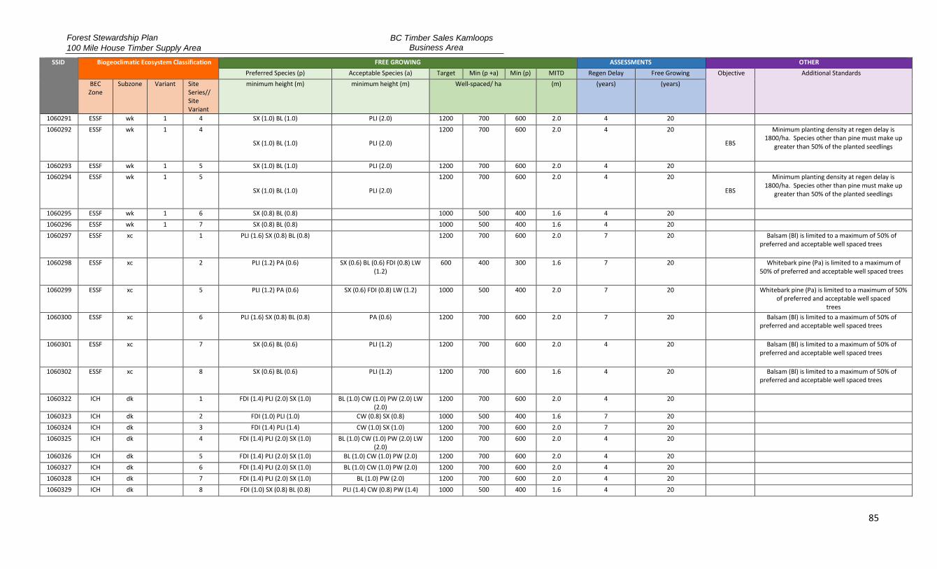
Forest Stewardship Plan
100 Mile House Timber Supply Area
BC Timber Sales Kamloops Business Area
85
SSID Biogeoclimatic Ecosystem Classification FREE GROWING ASSESSMENTS OTHER
Preferred Species (p) Acceptable Species (a) Target Min (p +a) Min (p) MITD Regen Delay Free Growing Objective Additional Standards
BEC Zone
Subzone Variant Site Series// Site Variant
minimum height (m) minimum height (m) Well-spaced/ ha (m) (years) (years)
1060291 ESSF wk 1 4 SX (1.0) BL (1.0) PLI (2.0) 1200 700 600 2.0 4 20 1060292 ESSF wk 1 4
SX (1.0) BL (1.0) PLI (2.0)
1200 700 600 2.0 4 20
EBS
Minimum planting density at regen delay is 1800/ha. Species other than pine must make up
greater than 50% of the planted seedlings
1060293 ESSF wk 1 5 SX (1.0) BL (1.0) PLI (2.0) 1200 700 600 2.0 4 20 1060294 ESSF wk 1 5
SX (1.0) BL (1.0) PLI (2.0)
1200 700 600 2.0 4 20
EBS
Minimum planting density at regen delay is 1800/ha. Species other than pine must make up
greater than 50% of the planted seedlings
1060295 ESSF wk 1 6 SX (0.8) BL (0.8) 1000 500 400 1.6 4 20 1060296 ESSF wk 1 7 SX (0.8) BL (0.8) 1000 500 400 1.6 4 20 1060297 ESSF xc 1 PLI (1.6) SX (0.8) BL (0.8) 1200 700 600 2.0 7 20 Balsam (Bl) is limited to a maximum of 50% of
preferred and acceptable well spaced trees
1060298 ESSF xc 2 PLI (1.2) PA (0.6) SX (0.6) BL (0.6) FDI (0.8) LW (1.2)
600 400 300 1.6 7 20 Whitebark pine (Pa) is limited to a maximum of 50% of preferred and acceptable well spaced trees
1060299 ESSF xc 5 PLI (1.2) PA (0.6) SX (0.6) FDI (0.8) LW (1.2) 1000 500 400 2.0 7 20 Whitebark pine (Pa) is limited to a maximum of 50% of preferred and acceptable well spaced
trees 1060300 ESSF xc 6 PLI (1.6) SX (0.8) BL (0.8) PA (0.6) 1200 700 600 2.0 7 20 Balsam (Bl) is limited to a maximum of 50% of
preferred and acceptable well spaced trees
1060301 ESSF xc 7 SX (0.6) BL (0.6) PLI (1.2) 1200 700 600 2.0 4 20 Balsam (Bl) is limited to a maximum of 50% of preferred and acceptable well spaced trees
1060302 ESSF xc 8 SX (0.6) BL (0.6) PLI (1.2) 1200 700 600 1.6 4 20 Balsam (Bl) is limited to a maximum of 50% of preferred and acceptable well spaced trees
1060322 ICH dk
1 FDI (1.4) PLI (2.0) SX (1.0) BL (1.0) CW (1.0) PW (2.0) LW (2.0)
1200 700 600 2.0 4 20
1060323 ICH dk 2 FDI (1.0) PLI (1.0) CW (0.8) SX (0.8) 1000 500 400 1.6 7 20 1060324 ICH dk 3 FDI (1.4) PLI (1.4) CW (1.0) SX (1.0) 1200 700 600 2.0 7 20 1060325 ICH dk
4 FDI (1.4) PLI (2.0) SX (1.0) BL (1.0) CW (1.0) PW (2.0) LW
(2.0) 1200 700 600 2.0 4 20
1060326 ICH dk 5 FDI (1.4) PLI (2.0) SX (1.0) BL (1.0) CW (1.0) PW (2.0) 1200 700 600 2.0 4 20 1060327 ICH dk 6 FDI (1.4) PLI (2.0) SX (1.0) BL (1.0) CW (1.0) PW (2.0) 1200 700 600 2.0 4 20 1060328 ICH dk 7 FDI (1.4) PLI (2.0) SX (1.0) BL (1.0) PW (2.0) 1200 700 600 2.0 4 20 1060329 ICH dk 8 FDI (1.0) SX (0.8) BL (0.8) PLI (1.4) CW (0.8) PW (1.4) 1000 500 400 1.6 4 20
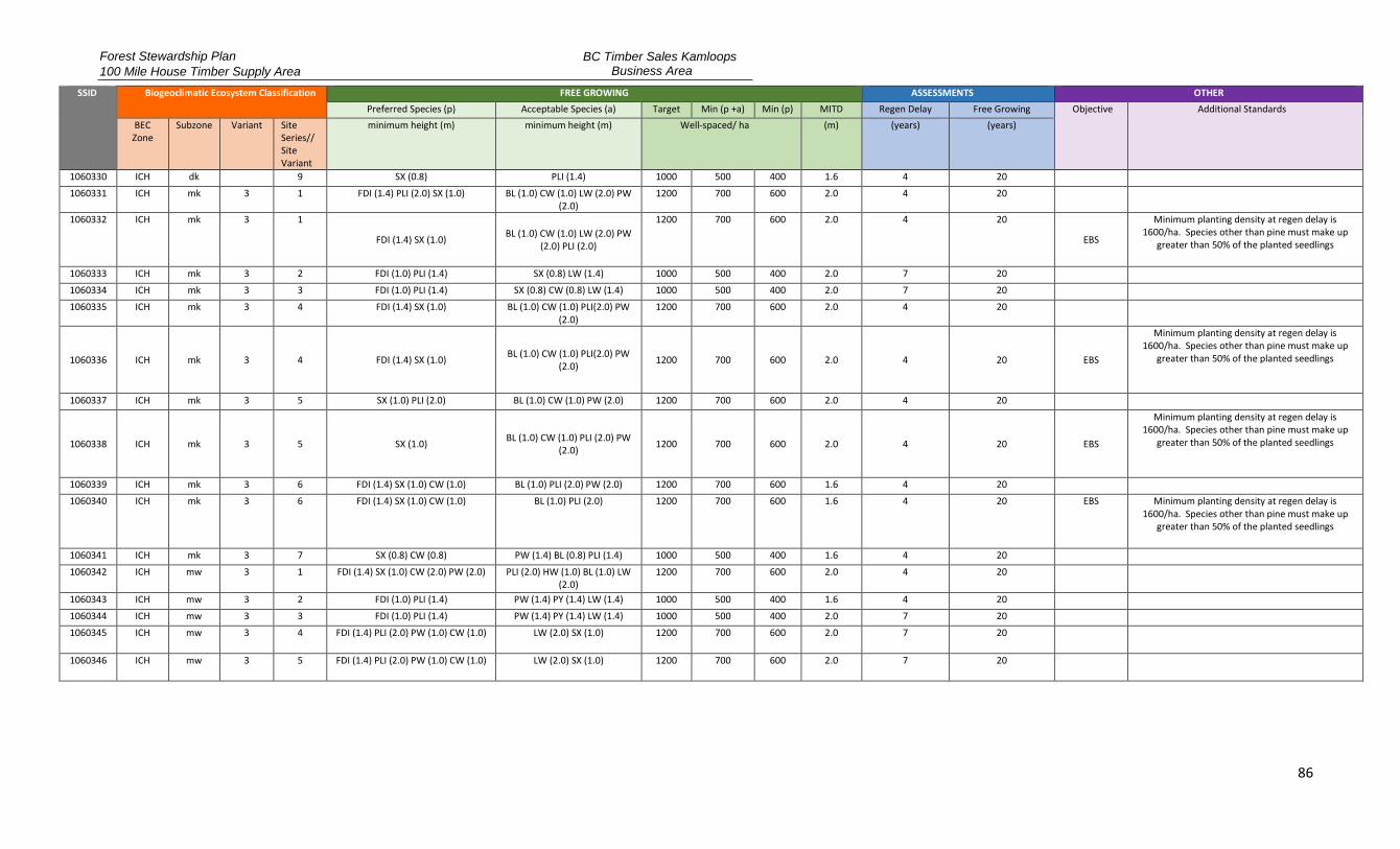
Forest Stewardship Plan
100 Mile House Timber Supply Area
BC Timber Sales Kamloops Business Area
86
SSID Biogeoclimatic Ecosystem Classification FREE GROWING ASSESSMENTS OTHER
Preferred Species (p) Acceptable Species (a) Target Min (p +a) Min (p) MITD Regen Delay Free Growing Objective Additional Standards
BEC Zone
Subzone Variant Site Series// Site Variant
minimum height (m) minimum height (m) Well-spaced/ ha (m) (years) (years)
1060330 ICH dk 9 SX (0.8) PLI (1.4) 1000 500 400 1.6 4 20 1060331 ICH mk 3 1 FDI (1.4) PLI (2.0) SX (1.0) BL (1.0) CW (1.0) LW (2.0) PW
(2.0) 1200 700 600 2.0 4 20
1060332 ICH mk 3 1
FDI (1.4) SX (1.0) BL (1.0) CW (1.0) LW (2.0) PW
(2.0) PLI (2.0)
1200 700 600 2.0 4 20
EBS
Minimum planting density at regen delay is 1600/ha. Species other than pine must make up
greater than 50% of the planted seedlings
1060333 ICH mk 3 2 FDI (1.0) PLI (1.4) SX (0.8) LW (1.4) 1000 500 400 2.0 7 20 1060334 ICH mk 3 3 FDI (1.0) PLI (1.4) SX (0.8) CW (0.8) LW (1.4) 1000 500 400 2.0 7 20 1060335 ICH mk 3 4 FDI (1.4) SX (1.0) BL (1.0) CW (1.0) PLI(2.0) PW
(2.0) 1200 700 600 2.0 4 20
1060336 ICH mk 3 4 FDI (1.4) SX (1.0) BL (1.0) CW (1.0) PLI(2.0) PW
(2.0) 1200 700 600 2.0 4 20 EBS
Minimum planting density at regen delay is 1600/ha. Species other than pine must make up
greater than 50% of the planted seedlings
1060337 ICH mk 3 5 SX (1.0) PLI (2.0) BL (1.0) CW (1.0) PW (2.0) 1200 700 600 2.0 4 20
1060338 ICH mk 3 5 SX (1.0) BL (1.0) CW (1.0) PLI (2.0) PW
(2.0) 1200 700 600 2.0 4 20 EBS
Minimum planting density at regen delay is 1600/ha. Species other than pine must make up
greater than 50% of the planted seedlings
1060339 ICH mk 3 6 FDI (1.4) SX (1.0) CW (1.0) BL (1.0) PLI (2.0) PW (2.0) 1200 700 600 1.6 4 20 1060340 ICH mk 3 6 FDI (1.4) SX (1.0) CW (1.0) BL (1.0) PLI (2.0) 1200 700 600 1.6 4 20 EBS Minimum planting density at regen delay is
1600/ha. Species other than pine must make up greater than 50% of the planted seedlings
1060341 ICH mk 3 7 SX (0.8) CW (0.8) PW (1.4) BL (0.8) PLI (1.4) 1000 500 400 1.6 4 20 1060342 ICH mw 3 1 FDI (1.4) SX (1.0) CW (2.0) PW (2.0) PLI (2.0) HW (1.0) BL (1.0) LW
(2.0) 1200 700 600 2.0 4 20
1060343 ICH mw 3 2 FDI (1.0) PLI (1.4) PW (1.4) PY (1.4) LW (1.4) 1000 500 400 1.6 4 20 1060344 ICH mw 3 3 FDI (1.0) PLI (1.4) PW (1.4) PY (1.4) LW (1.4) 1000 500 400 2.0 7 20 1060345 ICH mw 3 4 FDI (1.4) PLI (2.0) PW (1.0) CW (1.0) LW (2.0) SX (1.0) 1200 700 600 2.0 7 20
1060346 ICH mw 3 5 FDI (1.4) PLI (2.0) PW (1.0) CW (1.0) LW (2.0) SX (1.0) 1200 700 600 2.0 7 20
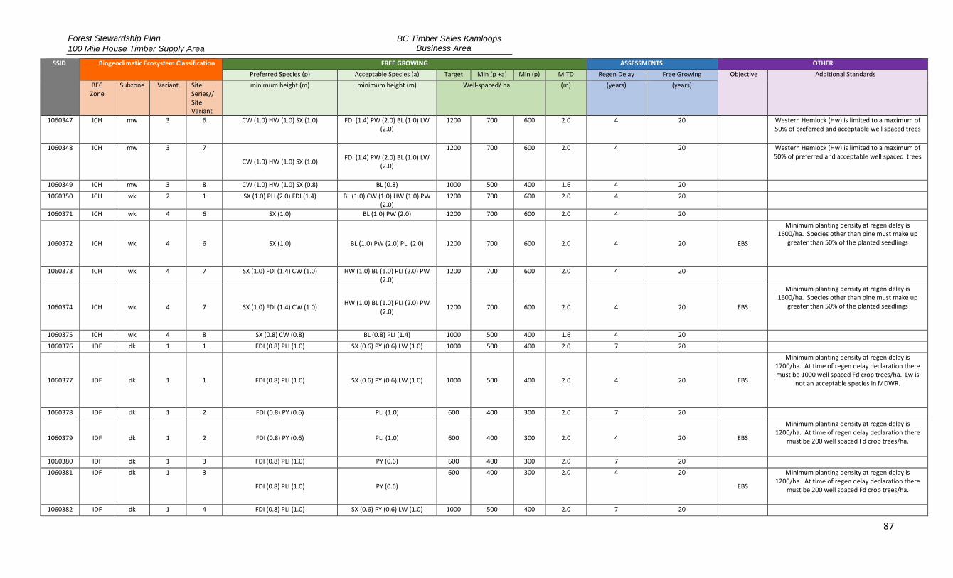
Forest Stewardship Plan
100 Mile House Timber Supply Area
BC Timber Sales Kamloops Business Area
87
SSID Biogeoclimatic Ecosystem Classification FREE GROWING ASSESSMENTS OTHER
Preferred Species (p) Acceptable Species (a) Target Min (p +a) Min (p) MITD Regen Delay Free Growing Objective Additional Standards
BEC Zone
Subzone Variant Site Series// Site Variant
minimum height (m) minimum height (m) Well-spaced/ ha (m) (years) (years)
1060347 ICH mw 3 6 CW (1.0) HW (1.0) SX (1.0) FDI (1.4) PW (2.0) BL (1.0) LW (2.0)
1200 700 600 2.0 4 20 Western Hemlock (Hw) is limited to a maximum of 50% of preferred and acceptable well spaced trees
1060348 ICH mw 3 7
CW (1.0) HW (1.0) SX (1.0) FDI (1.4) PW (2.0) BL (1.0) LW
(2.0)
1200 700 600 2.0 4 20 Western Hemlock (Hw) is limited to a maximum of 50% of preferred and acceptable well spaced trees
1060349 ICH mw 3 8 CW (1.0) HW (1.0) SX (0.8) BL (0.8) 1000 500 400 1.6 4 20 1060350 ICH wk 2 1 SX (1.0) PLI (2.0) FDI (1.4) BL (1.0) CW (1.0) HW (1.0) PW
(2.0) 1200 700 600 2.0 4 20
1060371 ICH wk 4 6 SX (1.0) BL (1.0) PW (2.0) 1200 700 600 2.0 4 20
1060372 ICH wk 4 6 SX (1.0) BL (1.0) PW (2.0) PLI (2.0) 1200 700 600 2.0 4 20 EBS
Minimum planting density at regen delay is 1600/ha. Species other than pine must make up
greater than 50% of the planted seedlings
1060373 ICH wk 4 7 SX (1.0) FDI (1.4) CW (1.0) HW (1.0) BL (1.0) PLI (2.0) PW (2.0)
1200 700 600 2.0 4 20
1060374 ICH wk 4 7 SX (1.0) FDI (1.4) CW (1.0) HW (1.0) BL (1.0) PLI (2.0) PW
(2.0) 1200 700 600 2.0 4 20 EBS
Minimum planting density at regen delay is 1600/ha. Species other than pine must make up
greater than 50% of the planted seedlings
1060375 ICH wk 4 8 SX (0.8) CW (0.8) BL (0.8) PLI (1.4) 1000 500 400 1.6 4 20 1060376 IDF dk 1 1 FDI (0.8) PLI (1.0) SX (0.6) PY (0.6) LW (1.0) 1000 500 400 2.0 7 20
1060377 IDF dk 1 1 FDI (0.8) PLI (1.0) SX (0.6) PY (0.6) LW (1.0) 1000 500 400 2.0 4 20 EBS
Minimum planting density at regen delay is 1700/ha. At time of regen delay declaration there must be 1000 well spaced Fd crop trees/ha. Lw is
not an acceptable species in MDWR.
1060378 IDF dk 1 2 FDI (0.8) PY (0.6) PLI (1.0) 600 400 300 2.0 7 20
1060379 IDF dk 1 2 FDI (0.8) PY (0.6) PLI (1.0) 600 400 300 2.0 4 20 EBS
Minimum planting density at regen delay is 1200/ha. At time of regen delay declaration there
must be 200 well spaced Fd crop trees/ha.
1060380 IDF dk 1 3 FDI (0.8) PLI (1.0) PY (0.6) 600 400 300 2.0 7 20 1060381 IDF dk 1 3
FDI (0.8) PLI (1.0) PY (0.6)
600 400 300 2.0 4 20
EBS
Minimum planting density at regen delay is 1200/ha. At time of regen delay declaration there
must be 200 well spaced Fd crop trees/ha.
1060382 IDF dk 1 4 FDI (0.8) PLI (1.0) SX (0.6) PY (0.6) LW (1.0) 1000 500 400 2.0 7 20

Forest Stewardship Plan
100 Mile House Timber Supply Area
BC Timber Sales Kamloops Business Area
88
SSID Biogeoclimatic Ecosystem Classification FREE GROWING ASSESSMENTS OTHER
Preferred Species (p) Acceptable Species (a) Target Min (p +a) Min (p) MITD Regen Delay Free Growing Objective Additional Standards
BEC Zone
Subzone Variant Site Series// Site Variant
minimum height (m) minimum height (m) Well-spaced/ ha (m) (years) (years)
1060383 IDF dk 1 4 FDI (0.8) PLI (1.0) SX (0.6) PY (0.6) LW (1.0) 1000 500 400 2.0 4 20 EBS
Minimum planting density at regen delay is 1700/ha. At time of regen delay declaration there must be 1000 well spaced Fd crop trees/ha. Lw is
not an acceptable species in MDWR.
1060384 IDF dk 1 5 FDI (0.8) SX (0.6) LW (1.0) PLI (1.0) BL (0.6) 1000 500 400 2.0 7 20
1060385 IDF dk 1 5 FDI (0.8) SX (0.6) LW (1.0) PLI (1.0) BL (0.6) 1000 500 400 2.0 4 20 EBS
Minimum planting density at regen delay is 1700/ha. At time of regen delay declaration there must be 1000 well spaced Fd crop trees/ha. Lw is
not an acceptable species in MDWR.
1060386 IDF dk 1 6 PLI (1.0) SX (0.6) BL (0.6) 1000 500 400 2.0 4 20 1060387 IDF dk 3 1 FDI (1.0) PLI (1.4) SX (0.8) PY (1.0) LW (2.0) 1200 700 600 2.0 7 20
1060388 IDF dk 3 1 FDI (1.0) PLI (1.4) SX (0.8) PY (1.0) LW (2.0) 1200 700 600 2.0 4 20 EBS
Applies to sites with slopes greater than 10%. Minimum planting density at regen delay is
1700/ha. At time of regen delay declaration there must be 1000 well spaced Fd crop trees/ha. Lw is
not an acceptable species in MDWR.
1060389 IDF dk 3 1 FDI (1.0) PLI (1.4) SX (0.8) PY (1.0) LW (2.0) 1200 700 600 2.0 4 20 EBS
Applies to sites with slopes 10% or less. Minimum planting density at regen delay is 1700/ha. At time of regen delay declaration there must be 200 well spaced Fd crop trees/ha. Lw is not an acceptable
species in MDWR.
1060390 IDF dk 3 2 FDI (0.8) PLI (1.0) PY (0.8) 800 500 400 2.0 7 20 1060391 IDF dk 3 2
FDI (0.8) PLI (1.0) PY (0.8)
800 500 400 2.0 4 20
EBS
Minimum planting density at regen delay is 1700/ha. At time of regen delay declaration there
must be 200 well spaced Fd crop trees/ha
1060392 IDF dk 3 3 FDI (0.8) PLI (1.0) PY (0.8) 800 500 400 2.0 7 20
1060393 IDF dk 3 3 FDI (0.8) PLI (1.0) PY (0.8) 800 500 400 2.0 4 20 EBS
Minimum planting density at regen delay is 1700/ha. At time of regen delay declaration there
must be 200 well spaced Fd crop trees/ha

Forest Stewardship Plan
100 Mile House Timber Supply Area
BC Timber Sales Kamloops Business Area
89
SSID Biogeoclimatic Ecosystem Classification FREE GROWING ASSESSMENTS OTHER
Preferred Species (p) Acceptable Species (a) Target Min (p +a) Min (p) MITD Regen Delay Free Growing Objective Additional Standards
BEC Zone
Subzone Variant Site Series// Site Variant
minimum height (m) minimum height (m) Well-spaced/ ha (m) (years) (years)
1060394 IDF dk 3 4 FDI (0.8) PLI (1.0) PY (1.0) 1000 500 400 2.0 7 20 1060395 IDF dk 3 4 FDI (0.8) PLI (1.0) PY (1.0) 1000 500 400 2.0 4 20 EBS Minimum planting density at regen delay is
1700/ha. At time of regen delay declaration there must be 200 well spaced Fd crop trees/ha
1060396 IDF dk 3 5 FDI (1.0) PLI (1.4) PY (0.8) 1200 700 600 2.0 7 20
1060397 IDF dk 3 5 FDI (1.0) PLI (1.4) PY (0.8) 1200 700 600 2.0 4 20 EBS
Minimum planting density at regen delay is 1700/ha. At time of regen delay declaration there
must be 1000 well spaced Fd crop trees/ha
1060398 IDF dk 3 6 FDI (1.0) PLI (1.4) PY (0.8) 1200 700 600 2.0 7 20
1060399 IDF dk 3 6 FDI (1.0) PLI (1.4) PY (0.8) 1200 700 600 2.0 4 20 EBS
Minimum planting density at regen delay is 1700/ha. At time of regen delay declaration there
must be 1000 well spaced Fd crop trees/ha
1060400 IDF dk 3 7 FDI (1.0) PLI (1.4) SX (0.8) 1200 700 600 2.0 4 20
1060401 IDF dk 3 7 FDI (1.0) PLI (1.4) SX (0.8)
1200 700 600 2.0 4 20 EBS
Minimum planting density at regen delay is 1700/ha. At time of regen delay declaration there
must be 1000 well spaced Fd crop trees/ha
1060402 IDF dk 3 8 FDI (1.0) PLI (1.4) SX (0.8) 1200 700 600 2.0 4 20 1060403 IDF dk 3 8
FDI (1.0) PLI (1.4) SX (0.8)
1200 700 600 2.0 4 20
EBS
Minimum planting density at regen delay is 1700/ha. At time of regen delay declaration there
must be 200 well spaced Fd crop trees/ha
1060404 IDF dk 3 9 SX (0.6) PLI (1.0) 1000 500 400 1.6 4 20 1060422 IDF mw 2 1 FDI (1.0) CW (0.8) PW (1.6) SX (0.8) PLI (1.6) LW (1.6) 1200 700 600 2.0 4 20 1060423 IDF mw 2 2 FDI (0.8) PLI (1.2) PY (1.2) PW (1.2) 600 400 300 1.6 4 20 1060424 IDF mw 2 3 FDI (1.0) LW (1.6) PW (1.6) PY (1.6) PLI
(1.6) 1000 500 400 1.6 7 20
1060425 IDF mw 2 4 FDI (1.0) SX (0.8) CW (0.8) PW (1.6) LW (1.6) HW (1.6) 1200 700 600 2.0 4 20 1060426 IDF mw 2 5 CW (0.6) SX (0.6) HW (0.6) BL (0.6) 400 200 150 1.6 4 20
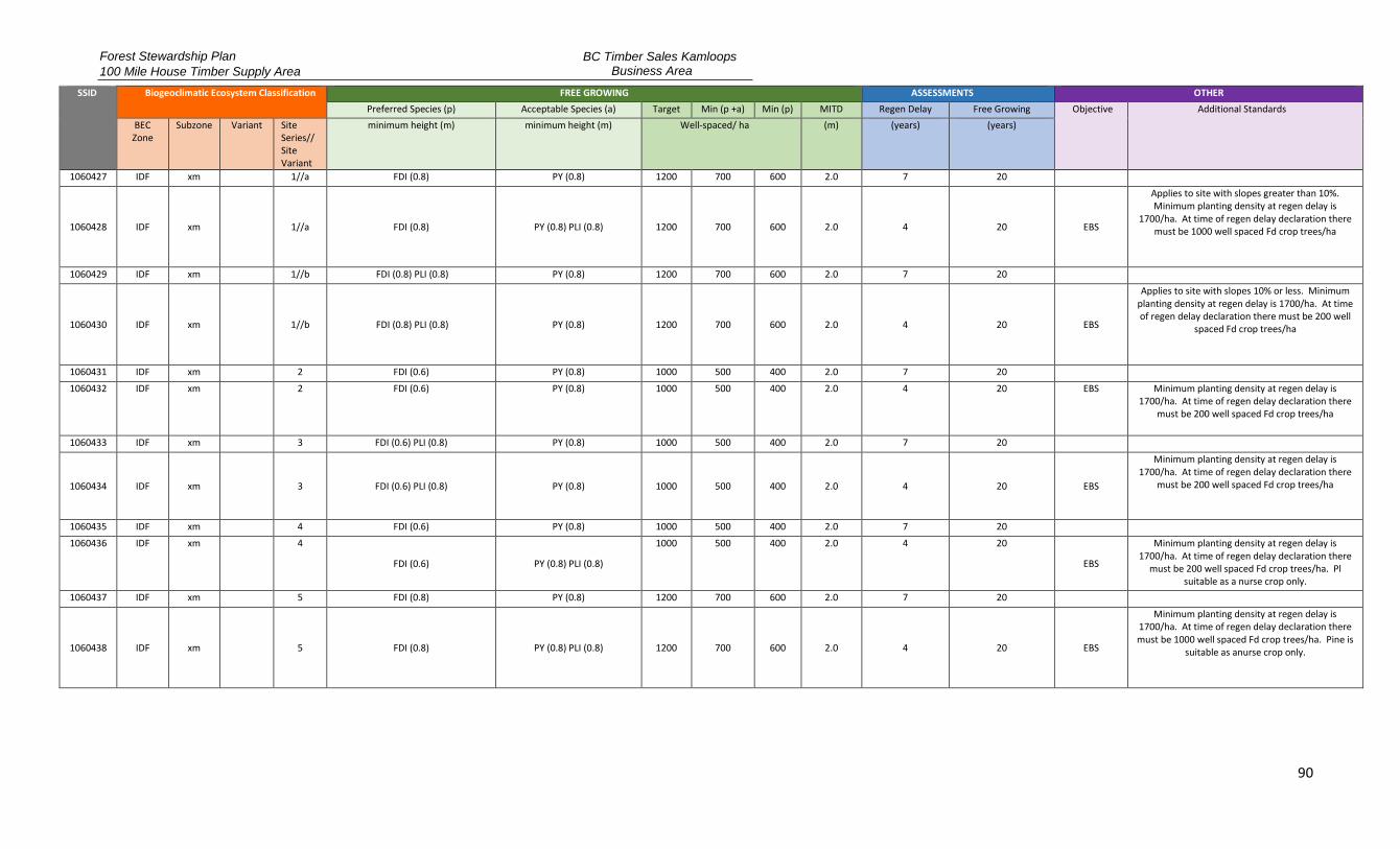
Forest Stewardship Plan
100 Mile House Timber Supply Area
BC Timber Sales Kamloops Business Area
90
SSID Biogeoclimatic Ecosystem Classification FREE GROWING ASSESSMENTS OTHER
Preferred Species (p) Acceptable Species (a) Target Min (p +a) Min (p) MITD Regen Delay Free Growing Objective Additional Standards
BEC Zone
Subzone Variant Site Series// Site Variant
minimum height (m) minimum height (m) Well-spaced/ ha (m) (years) (years)
1060427 IDF xm 1//a FDI (0.8) PY (0.8) 1200 700 600 2.0 7 20
1060428 IDF xm
1//a FDI (0.8) PY (0.8) PLI (0.8) 1200 700 600 2.0 4 20 EBS
Applies to site with slopes greater than 10%. Minimum planting density at regen delay is
1700/ha. At time of regen delay declaration there must be 1000 well spaced Fd crop trees/ha
1060429 IDF xm 1//b FDI (0.8) PLI (0.8) PY (0.8) 1200 700 600 2.0 7 20
1060430 IDF xm
1//b FDI (0.8) PLI (0.8) PY (0.8) 1200 700 600 2.0 4 20 EBS
Applies to site with slopes 10% or less. Minimum planting density at regen delay is 1700/ha. At time of regen delay declaration there must be 200 well
spaced Fd crop trees/ha
1060431 IDF xm 2 FDI (0.6) PY (0.8) 1000 500 400 2.0 7 20 1060432 IDF xm 2 FDI (0.6) PY (0.8) 1000 500 400 2.0 4 20 EBS Minimum planting density at regen delay is
1700/ha. At time of regen delay declaration there must be 200 well spaced Fd crop trees/ha
1060433 IDF xm 3 FDI (0.6) PLI (0.8) PY (0.8) 1000 500 400 2.0 7 20
1060434 IDF xm
3 FDI (0.6) PLI (0.8) PY (0.8) 1000 500 400 2.0 4 20 EBS
Minimum planting density at regen delay is 1700/ha. At time of regen delay declaration there
must be 200 well spaced Fd crop trees/ha
1060435 IDF xm 4 FDI (0.6) PY (0.8) 1000 500 400 2.0 7 20 1060436 IDF xm 4
FDI (0.6) PY (0.8) PLI (0.8)
1000 500 400 2.0 4 20
EBS
Minimum planting density at regen delay is 1700/ha. At time of regen delay declaration there
must be 200 well spaced Fd crop trees/ha. Pl suitable as a nurse crop only.
1060437 IDF xm 5 FDI (0.8) PY (0.8) 1200 700 600 2.0 7 20
1060438 IDF xm
5 FDI (0.8) PY (0.8) PLI (0.8) 1200 700 600 2.0 4 20 EBS
Minimum planting density at regen delay is 1700/ha. At time of regen delay declaration there must be 1000 well spaced Fd crop trees/ha. Pine is
suitable as anurse crop only.

Forest Stewardship Plan
100 Mile House Timber Supply Area
BC Timber Sales Kamloops Business Area
91
SSID Biogeoclimatic Ecosystem Classification FREE GROWING ASSESSMENTS OTHER
Preferred Species (p) Acceptable Species (a) Target Min (p +a) Min (p) MITD Regen Delay Free Growing Objective Additional Standards
BEC Zone
Subzone Variant Site Series// Site Variant
minimum height (m) minimum height (m) Well-spaced/ ha (m) (years) (years)
1060439 IDF xm 6 FDI (0.8) PLI (1.0) PY (1.0) LW (1.0) 1200 700 600 2.0 7 20
1060440 IDF xm
6 FDI (0.8) PLI (1.0) PY (1.0) LW (1.0) 1200 700 600 2.0 4 20 EBS
Minimum planting density at regen delay is 1700/ha. At time of regen delay declaration there must be 1000 well spaced Fd crop trees/ha. Lw is not an acceptable species in MDWR. Pl suitable as
a nurse crop only.
1060441 IDF xm 7 FDI (0.8) PLI (1.0) 1200 700 600 2.0 7 20
1060442 IDF xm
7 FDI (0.8) PLI (1.0) 1200 700 600 2.0 4 20 EBS
Minimum planting density at regen delay is 1700/ha. At time of regen delay declaration there
must be 1000 well spaced Fd crop trees/ha. Pl suitable as a nurse crop only.
1060443 IDF xm 8 FDI (0.8) SX (0.8) PLI (0.8) 1200 700 600 1.6 4 20
1060444 IDF xm
8 FDI (0.8) SX (0.8) PLI (0.8) 1200 700 600 1.6 4 20 EBS
Minimum planting density at regen delay is 1700/ha. At time of regen delay declaration there
must be 200 well spaced Fd crop trees/ha
1060445 IDF xm 9 SX (0.6) PLI (0.8) 1000 500 400 1.6 4 20 1060446 IDF xw 1 FDI (0.8) PY (0.8) 1200 700 600 2.0 7 20 1060447 IDF xw 2 FDI (0.6) PY (0.6) 600 400 300 2.0 7 20 1060448 IDF xw 3 FDI (0.6) PY (0.6) 600 400 300 2.0 7 20 1060449 IDF xw 4 FDI (0.6) PY (0.6) 800 500 400 2.0 7 20 1060450 IDF xw 5 FDI (0.8) 1200 700 600 2.0 7 20 1060451 IDF xw 6 FDI (0.6) SX (0.6) 1200 700 600 2.0 4 20 1060452 IDF xw 7 FDI (0.6) SX (0.6) 1000 500 400 1.6 4 20 1060470 MS xk 1 FDI (0.8) PLI (0.8) BL (0.8) LW (1.4) 1200 700 600 2.0 7 20 1060471 MS xk 2 FDI (0.6) PLI (1.0) SX (0.6) BL (0.6) 1000 500 400 1.6 7 20 1060472 MS xk 5//a FDI (0.6) PLI (1.0) PY (1.0) LW (1.0) 1000 500 400 2.0 7 20 1060473 MS xk 5//b PLI (1.0) SX (0.6) LW (1.0) FDI (0.6) 1000 500 400 2.0 7 20 1060474 MS xk 6 PLI (1.4) SX (0.8) BL (0.7) FDI (0.8) 1200 700 600 2.0 7 20 Balsam (Bl) is limited to a maximum of 50% of
preferred and acceptable well spaced trees
1060475 MS xk 8 PLI (1.4) SX (0.8) BL (0.8) 1200 700 600 2.0 4 20 1060476 MS xk 9 SX (0.6) BL (0.6) PLI (1.0) 1000 500 400 1.6 4 20
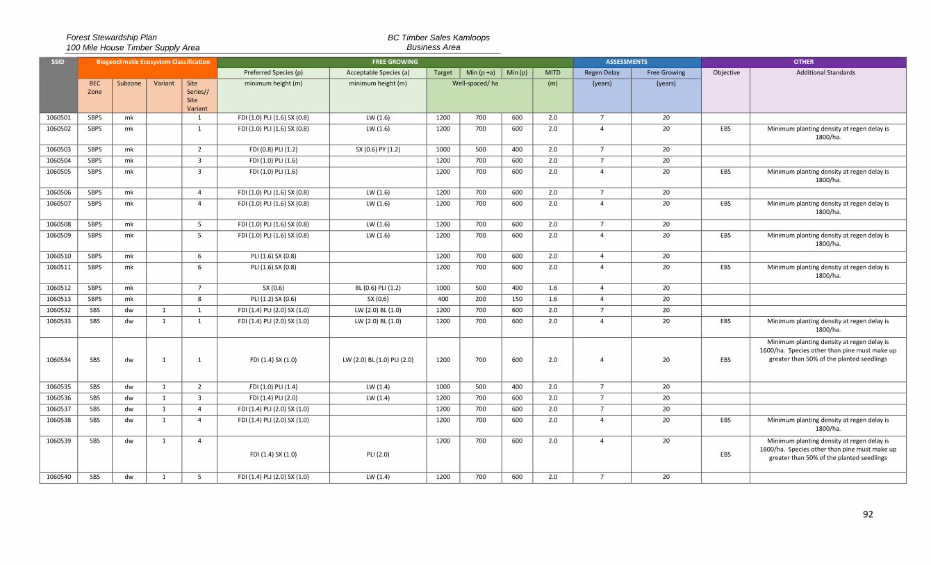
Forest Stewardship Plan
100 Mile House Timber Supply Area
BC Timber Sales Kamloops Business Area
92
SSID Biogeoclimatic Ecosystem Classification FREE GROWING ASSESSMENTS OTHER
Preferred Species (p) Acceptable Species (a) Target Min (p +a) Min (p) MITD Regen Delay Free Growing Objective Additional Standards
BEC Zone
Subzone Variant Site Series// Site Variant
minimum height (m) minimum height (m) Well-spaced/ ha (m) (years) (years)
1060501 SBPS mk 1 FDI (1.0) PLI (1.6) SX (0.8) LW (1.6) 1200 700 600 2.0 7 20 1060502 SBPS mk
1 FDI (1.0) PLI (1.6) SX (0.8) LW (1.6) 1200 700 600 2.0 4 20 EBS Minimum planting density at regen delay is
1800/ha.
1060503 SBPS mk 2 FDI (0.8) PLI (1.2) SX (0.6) PY (1.2) 1000 500 400 2.0 7 20 1060504 SBPS mk 3 FDI (1.0) PLI (1.6) 1200 700 600 2.0 7 20 1060505 SBPS mk
3 FDI (1.0) PLI (1.6)
1200 700 600 2.0 4 20 EBS Minimum planting density at regen delay is
1800/ha.
1060506 SBPS mk 4 FDI (1.0) PLI (1.6) SX (0.8) LW (1.6) 1200 700 600 2.0 7 20 1060507 SBPS mk
4 FDI (1.0) PLI (1.6) SX (0.8) LW (1.6) 1200 700 600 2.0 4 20 EBS Minimum planting density at regen delay is
1800/ha.
1060508 SBPS mk 5 FDI (1.0) PLI (1.6) SX (0.8) LW (1.6) 1200 700 600 2.0 7 20 1060509 SBPS mk
5 FDI (1.0) PLI (1.6) SX (0.8) LW (1.6) 1200 700 600 2.0 4 20 EBS Minimum planting density at regen delay is
1800/ha.
1060510 SBPS mk 6 PLI (1.6) SX (0.8) 1200 700 600 2.0 4 20 1060511 SBPS mk
6 PLI (1.6) SX (0.8)
1200 700 600 2.0 4 20 EBS Minimum planting density at regen delay is
1800/ha.
1060512 SBPS mk 7 SX (0.6) BL (0.6) PLI (1.2) 1000 500 400 1.6 4 20 1060513 SBPS mk 8 PLI (1.2) SX (0.6) SX (0.6) 400 200 150 1.6 4 20 1060532 SBS dw 1 1 FDI (1.4) PLI (2.0) SX (1.0) LW (2.0) BL (1.0) 1200 700 600 2.0 7 20 1060533 SBS dw 1 1 FDI (1.4) PLI (2.0) SX (1.0) LW (2.0) BL (1.0) 1200 700 600 2.0 4 20 EBS Minimum planting density at regen delay is
1800/ha.
1060534 SBS dw 1 1 FDI (1.4) SX (1.0) LW (2.0) BL (1.0) PLI (2.0) 1200 700 600 2.0 4 20 EBS
Minimum planting density at regen delay is 1600/ha. Species other than pine must make up
greater than 50% of the planted seedlings
1060535 SBS dw 1 2 FDI (1.0) PLI (1.4) LW (1.4) 1000 500 400 2.0 7 20 1060536 SBS dw 1 3 FDI (1.4) PLI (2.0) LW (1.4) 1200 700 600 2.0 7 20 1060537 SBS dw 1 4 FDI (1.4) PLI (2.0) SX (1.0) 1200 700 600 2.0 7 20 1060538 SBS dw 1 4 FDI (1.4) PLI (2.0) SX (1.0)
1200 700 600 2.0 4 20 EBS Minimum planting density at regen delay is
1800/ha.
1060539 SBS dw 1 4
FDI (1.4) SX (1.0) PLI (2.0)
1200 700 600 2.0 4 20
EBS
Minimum planting density at regen delay is 1600/ha. Species other than pine must make up
greater than 50% of the planted seedlings
1060540 SBS dw 1 5 FDI (1.4) PLI (2.0) SX (1.0) LW (1.4) 1200 700 600 2.0 7 20

Forest Stewardship Plan
100 Mile House Timber Supply Area
BC Timber Sales Kamloops Business Area
93
SSID Biogeoclimatic Ecosystem Classification FREE GROWING ASSESSMENTS OTHER
Preferred Species (p) Acceptable Species (a) Target Min (p +a) Min (p) MITD Regen Delay Free Growing Objective Additional Standards
BEC Zone
Subzone Variant Site Series// Site Variant
minimum height (m) minimum height (m) Well-spaced/ ha (m) (years) (years)
1060541 SBS dw 1 5 FDI (1.4) PLI (2.0) SX (1.0) LW (1.4) 1200 700 600 2.0 4 20 EBS Minimum planting density at regen delay is 1800/ha.
1060542 SBS dw 1 5 FDI (1.4) SX (1.0) LW (1.4) PLI (2.0) 1200 700 600 2.0 4 20 EBS
Minimum planting density at regen delay is 1600/ha. Species other than pine must make up
greater than 50% of the planted seedlings
1060543 SBS dw 1 6 FDI (1.4) PLI (2.0) SX (1.0) 1200 700 600 2.0 7 20
1060544 SBS dw 1 6 FDI (1.4) SX (1.0) PLI (2.0) BL (1.0) 1200 700 600 2.0 4 20 EBS
Minimum planting density at regen delay is 1600/ha. Species other than pine must make up
greater than 50% of the planted seedlings
1060546 SBS dw 1 7 FDI (1.4) PLI (2.0) SX (1.0) BL (1.0) 1200 700 600 2.0 4 20
SBS dw 1 7 FDI (1.4) SX (1.0) BL (1.0) PLI (2.0) 1200 700 600 2.0 4 20 EBS
Minimum planting density at regen delay is 1600/ha. Species other than pine must make up
greater than 50% of the planted seedlings
1060547 SBS dw 1 8 FDI (1.4) PLI (2.0) SX (1.0) BL (1.0) 1200 700 600 2.0 4 20
1060548 SBS dw 1 8 FDI (1.4) SX (1.0) BL (1.0) PLI (2.0) 1200 700 600 2.0 4 20 EBS
Minimum planting density at regen delay is 1600/ha. Species other than pine must make up
greater than 50% of the planted seedlings
1060549 SBS dw 1 9 SX (0.8) BL (0.8) PLI (1.4) 1000 500 400 1.6 4 20 1060550 SBS dw 2 1 FDI (1.4) PLI (2.0) SX (1.0) LW (2.0) 1200 700 600 2.0 7 20 1060551 SBS dw 2 1 FDI (1.4) PLI (2.0) SX (1.0) LW (2.0) 1200 700 600 2.0 4 20 EBS Minimum planting density at regen delay is
1800/ha.
1060552 SBS dw 2 1
FDI (1.4) SX (1.0) LW (2.0) PLI (2.0)
1200 700 600 2.0 4 20
EBS
Minimum planting density at regen delay is 1600/ha. Species other than pine must make up
greater than 50% of the planted seedlings
1060553 SBS dw 2 2 FDI (1.0) PLI (1.4) LW (1.4) 1000 500 400 2.0 7 20 1060554 SBS dw 2 3 FDI (1.4) PLI (2.0) 1200 700 600 2.0 7 20 1060555 SBS dw 2 4 FDI (1.4) PLI (2.0) LW (2.0) 1200 700 600 2.0 7 20 1060556 SBS dw 2 4 FDI (1.4) PLI (2.0) LW (2.0) 1200 700 600 2.0 4 20 EBS Minimum planting density at regen delay is
1800/ha.

Forest Stewardship Plan
100 Mile House Timber Supply Area
BC Timber Sales Kamloops Business Area
94
SSID Biogeoclimatic Ecosystem Classification FREE GROWING ASSESSMENTS OTHER
Preferred Species (p) Acceptable Species (a) Target Min (p +a) Min (p) MITD Regen Delay Free Growing Objective Additional Standards
BEC Zone
Subzone Variant Site Series// Site Variant
minimum height (m) minimum height (m) Well-spaced/ ha (m) (years) (years)
1060557 SBS dw 2 5 FDI (1.4) PLI (2.0) SX (1.0) LW (2.0) 1200 700 600 2.0 7 20 1060558 SBS dw 2 5 FDI (1.4) PLI (2.0) SX (1.0) LW (2.0) 1200 700 600 2.0 4 20 EBS Minimum planting density at regen delay is
1800/ha.
1060559 SBS dw 2 5 FDI (1.4) SX (1.0) LW (2.0) PLI (2.0) 1200 700 600 2.0 4 20 EBS
Minimum planting density at regen delay is 1600/ha. Species other than pine must make up
greater than 50% of the planted seedlings
1060560 SBS dw 2 6 FDI (1.4) PLI (2.0) SX (1.0) LW (2.0) 1200 700 600 2.0 7 20 1060561 SBS dw 2 6 FDI (1.4) PLI (2.0) SX (1.0) LW (2.0) 1200 700 600 2.0 4 20 EBS Minimum planting density at regen delay is
1800/ha.
1060562 SBS dw 2 6 FDI (1.4) SX (1.0) LW (2.0) PLI (2.0) 1200 700 600 2.0 4 20 EBS
Minimum planting density at regen delay is 1600/ha. Species other than pine must make up
greater than 50% of the planted seedlings
1060563 SBS dw 2 7 PLI (2.0) SX (1.0) BL (1.0) 1200 700 600 2.0 7 20 1060564 SBS dw 2 8 FDI (1.4) PLI (2.0) SX (1.0) BL (1.0) 1200 700 600 2.0 4 20 1060565 SBS dw 2 8 FDI (1.4) PLI (2.0) SX (1.0) BL (1.0) 1200 700 600 2.0 4 20 EBS Minimum planting density at regen delay is
1800/ha.
1060566 SBS dw 2 8 FDI (1.4) SX (1.0) BL (1.0) PLI (2.0) 1200 700 600 2.0 4 20 EBS
Minimum planting density at regen delay is 1600/ha. Species other than pine must make up
greater than 50% of the planted seedlings
1060567 SBS dw 2 9 FDI (1.4) PLI (2.0) SX (1.0) BL (1.0) 1200 700 600 2.0 4 20 1060568 SBS dw 2 10 SX (0.8) BL (0.8) PLI (1.4) 1000 500 400 1.6 4 20 1060569 SBS dw 2 11 PLI (1.4) SX (0.8) 400 200 150 1.6 4 20 1060570 SBS mc 1 1 FDI (1.0) PLI (1.6) SX (0.8) BL (0.8) LW (1.6) 1200 700 600 2.0 7 20 1060571 SBS mc 1 1 FDI (1.0) PLI (1.6) SX (0.8) BL (0.8) LW (1.6) 1200 700 600 2.0 4 20 EBS Minimum planting density at regen delay is
1800/ha.
1060572 SBS mc 1 2 PLI (1.4) SX (0.6) BL (0.6) LW (1.4) 1000 500 400 2.0 7 20 1060573 SBS mc 1 3 FDI (1.0) PLI (1.4) SX (0.8) LW (1.4) 1200 700 600 2.0 7 20 1060574 SBS mc 1 3 FDI (1.0) PLI (1.4) SX (0.8) LW (1.4) 1200 700 600 2.0 4 20 EBS Minimum planting density at regen delay is
1800/ha.
1060575 SBS mc 1 4 PLI (1.6) SX (0.8) BL (0.8) 1200 700 600 2.0 7 20 1060576 SBS mc 1 4 PLI (1.6) SX (0.8) BL (0.8) 1200 700 600 2.0 4 20 EBS Minimum planting density at regen delay is
1800/ha.
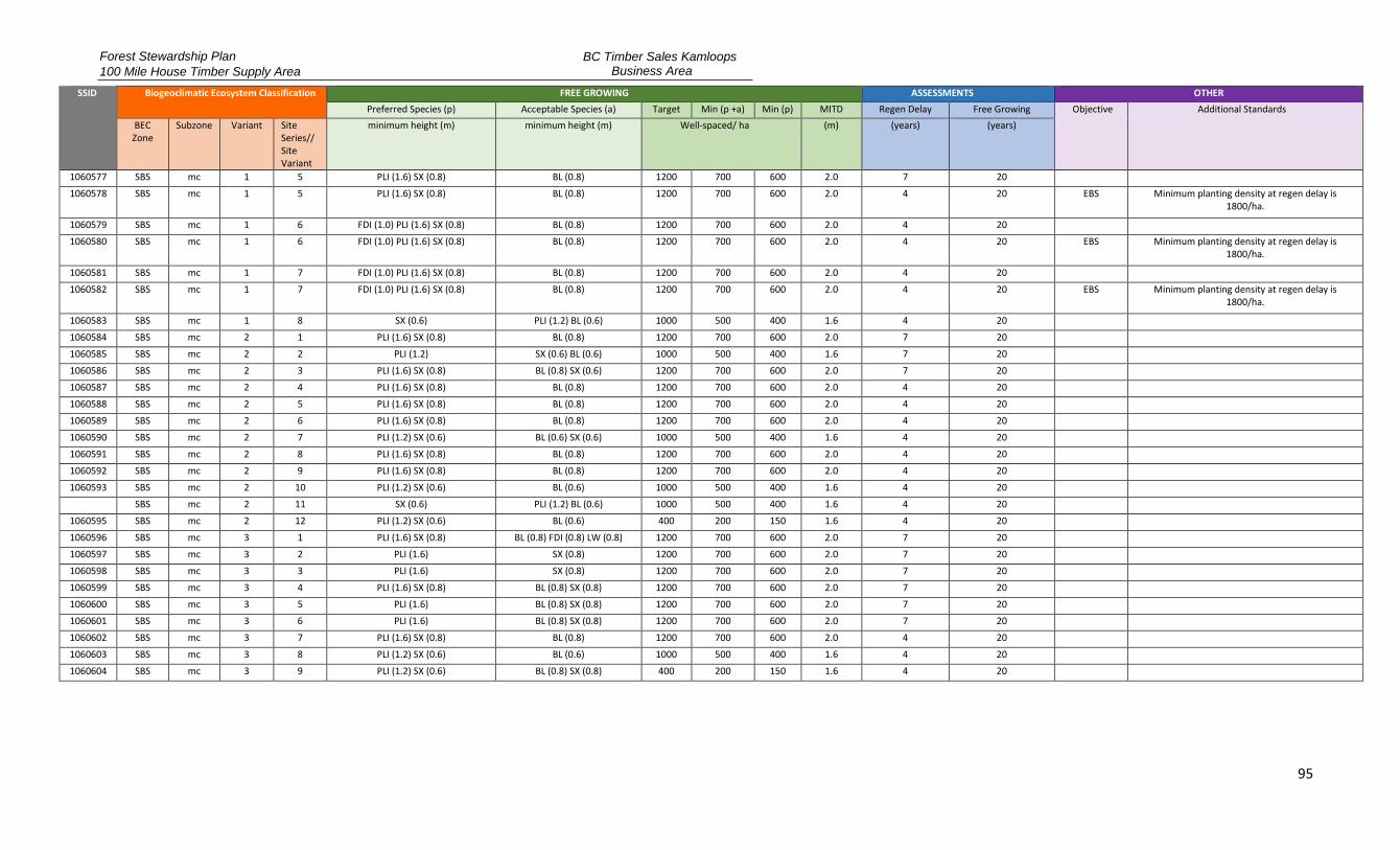
Forest Stewardship Plan
100 Mile House Timber Supply Area
BC Timber Sales Kamloops Business Area
95
SSID Biogeoclimatic Ecosystem Classification FREE GROWING ASSESSMENTS OTHER
Preferred Species (p) Acceptable Species (a) Target Min (p +a) Min (p) MITD Regen Delay Free Growing Objective Additional Standards
BEC Zone
Subzone Variant Site Series// Site Variant
minimum height (m) minimum height (m) Well-spaced/ ha (m) (years) (years)
1060577 SBS mc 1 5 PLI (1.6) SX (0.8) BL (0.8) 1200 700 600 2.0 7 20 1060578 SBS mc 1 5 PLI (1.6) SX (0.8) BL (0.8) 1200 700 600 2.0 4 20 EBS Minimum planting density at regen delay is
1800/ha.
1060579 SBS mc 1 6 FDI (1.0) PLI (1.6) SX (0.8) BL (0.8) 1200 700 600 2.0 4 20 1060580 SBS mc 1 6 FDI (1.0) PLI (1.6) SX (0.8) BL (0.8) 1200 700 600 2.0 4 20 EBS Minimum planting density at regen delay is
1800/ha.
1060581 SBS mc 1 7 FDI (1.0) PLI (1.6) SX (0.8) BL (0.8) 1200 700 600 2.0 4 20 1060582 SBS mc 1 7 FDI (1.0) PLI (1.6) SX (0.8) BL (0.8) 1200 700 600 2.0 4 20 EBS Minimum planting density at regen delay is
1800/ha.
1060583 SBS mc 1 8 SX (0.6) PLI (1.2) BL (0.6) 1000 500 400 1.6 4 20 1060584 SBS mc 2 1 PLI (1.6) SX (0.8) BL (0.8) 1200 700 600 2.0 7 20 1060585 SBS mc 2 2 PLI (1.2) SX (0.6) BL (0.6) 1000 500 400 1.6 7 20 1060586 SBS mc 2 3 PLI (1.6) SX (0.8) BL (0.8) SX (0.6) 1200 700 600 2.0 7 20 1060587 SBS mc 2 4 PLI (1.6) SX (0.8) BL (0.8) 1200 700 600 2.0 4 20 1060588 SBS mc 2 5 PLI (1.6) SX (0.8) BL (0.8) 1200 700 600 2.0 4 20 1060589 SBS mc 2 6 PLI (1.6) SX (0.8) BL (0.8) 1200 700 600 2.0 4 20 1060590 SBS mc 2 7 PLI (1.2) SX (0.6) BL (0.6) SX (0.6) 1000 500 400 1.6 4 20 1060591 SBS mc 2 8 PLI (1.6) SX (0.8) BL (0.8) 1200 700 600 2.0 4 20 1060592 SBS mc 2 9 PLI (1.6) SX (0.8) BL (0.8) 1200 700 600 2.0 4 20 1060593 SBS mc 2 10 PLI (1.2) SX (0.6) BL (0.6) 1000 500 400 1.6 4 20
SBS mc 2 11 SX (0.6) PLI (1.2) BL (0.6) 1000 500 400 1.6 4 20 1060595 SBS mc 2 12 PLI (1.2) SX (0.6) BL (0.6) 400 200 150 1.6 4 20 1060596 SBS mc 3 1 PLI (1.6) SX (0.8) BL (0.8) FDI (0.8) LW (0.8) 1200 700 600 2.0 7 20 1060597 SBS mc 3 2 PLI (1.6) SX (0.8) 1200 700 600 2.0 7 20 1060598 SBS mc 3 3 PLI (1.6) SX (0.8) 1200 700 600 2.0 7 20 1060599 SBS mc 3 4 PLI (1.6) SX (0.8) BL (0.8) SX (0.8) 1200 700 600 2.0 7 20 1060600 SBS mc 3 5 PLI (1.6) BL (0.8) SX (0.8) 1200 700 600 2.0 7 20 1060601 SBS mc 3 6 PLI (1.6) BL (0.8) SX (0.8) 1200 700 600 2.0 7 20 1060602 SBS mc 3 7 PLI (1.6) SX (0.8) BL (0.8) 1200 700 600 2.0 4 20 1060603 SBS mc 3 8 PLI (1.2) SX (0.6) BL (0.6) 1000 500 400 1.6 4 20 1060604 SBS mc 3 9 PLI (1.2) SX (0.6) BL (0.8) SX (0.8) 400 200 150 1.6 4 20
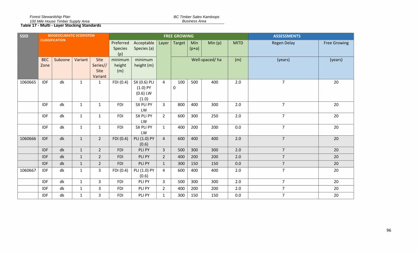
Forest Stewardship Plan
100 Mile House Timber Supply Area
BC Timber Sales Kamloops Business Area
96
Table 17 - Multi - Layer Stocking Standards
SSID BIOGEOCLIMATIC ECOSYSTEM CLASSIFICATION
FREE GROWING ASSESSMENTS
Preferred Species
(p)
Acceptable Species (a)
Layer Target Min (p+a)
Min (p) MITD Regen Delay Free Growing
BEC Zone
Subzone Variant Site Series//
Site Variant
minimum height
(m)
minimum height (m)
Well-spaced/ ha (m) (years) (years)
1060665 IDF dk 1 1 FDI (0.4) SX (0.6) PLI (1.0) PY (0.6) LW
(1.0)
4 1000
500 400 2.0 7 20
IDF dk 1 1 FDI SX PLI PY
LW 3 800 400 300 2.0 7 20
IDF dk 1 1 FDI SX PLI PY
LW 2 600 300 250 2.0 7 20
IDF dk 1 1 FDI SX PLI PY LW
1 400 200 200 0.0 7 20
1060666 IDF dk 1 2 FDI (0.4) PLI (1.0) PY (0.6)
4 600 400 400 2.0 7 20
IDF dk 1 2 FDI PLI PY 3 500 300 300 2.0 7 20
IDF dk 1 2 FDI PLI PY 2 400 200 200 2.0 7 20
IDF dk 1 2 FDI PLI PY 1 300 150 150 0.0 7 20
1060667 IDF dk 1 3 FDI (0.4) PLI (1.0) PY (0.6)
4 600 400 400 2.0 7 20
IDF dk 1 3 FDI PLI PY 3 500 300 300 2.0 7 20
IDF dk 1 3 FDI PLI PY 2 400 200 200 2.0 7 20
IDF dk 1 3 FDI PLI PY 1 300 150 150 0.0 7 20

Forest Stewardship Plan
100 Mile House Timber Supply Area
BC Timber Sales Kamloops Business Area
97
SSID BIOGEOCLIMATIC ECOSYSTEM CLASSIFICATION
FREE GROWING ASSESSMENTS
Preferred Species
(p)
Acceptable Species (a)
Layer Target Min (p+a)
Min (p) MITD Regen Delay Free Growing
BEC Zone
Subzone Variant Site Series//
Site Variant
minimum height
(m)
minimum height (m)
Well-spaced/ ha (m) (years) (years)
1060668 IDF dk 1 4 FDI (0.4) SX (0.6) PLI (1.0) PY (0.6) LW
(1.0)
4 1000
500 400 2.0 7 20
IDF dk 1 4 FDI SX PLI PY
LW 3 800 400 300 2.0 7 20
IDF dk 1 4 FDI SX PLI PY
LW 2 600 300 250 2.0 7 20
IDF dk 1 4 FDI SX PLI PY LW
1 400 200 200 0.0 7 20
1060669 IDF dk 1 5 FDI (0.4) SX (0.6)
PLI (1.0) LW (1.0) BL (0.6)
4 1000
500 400 2.0 7 20
IDF dk 1 5 FDI SX PLI LW BL 3 800 400 300 2.0 7 20
IDF dk 1 5 FDI SX PLI LW BL 2 600 300 250 2.0 7 20
IDF dk 1 5 FDI SX PLI LW BL 1 400 200 200 0.0 7 20
1060670 IDF dk 3 1 FDI (0.4) SX (0.8) PLI (1.0) PY
(1.0)
4 1200
700 600 2.0 7 20
IDF dk 3 1 FDI SX PLI PY 3 100
0 500 400 2.0 7 20
IDF dk 3 1 FDI SX PLI PY 2 800 400 300 2.0 7 20
IDF dk 3 1 FDI SX PLI PY 1 600 300 250 0.0 7 20

Forest Stewardship Plan
100 Mile House Timber Supply Area
BC Timber Sales Kamloops Business Area
98
SSID BIOGEOCLIMATIC ECOSYSTEM CLASSIFICATION
FREE GROWING ASSESSMENTS
Preferred Species
(p)
Acceptable Species (a)
Layer Target Min (p+a)
Min (p) MITD Regen Delay Free Growing
BEC Zone
Subzone Variant Site Series//
Site Variant
minimum height
(m)
minimum height (m)
Well-spaced/ ha (m) (years) (years)
1060671 IDF dk 3 2 FDI (0.4) PLI (1.0) PY (0.8)
4 800 400 400 2.0 7 20
IDF dk 3 2 FDI PLI PY 3 600 300 300 2.0 7 20
IDF dk 3 2 FDI PLI PY 2 400 200 200 2.0 7 20
IDF dk 3 2 FDI PLI PY 1 300 150 150 0.0 7 20
1060672 IDF dk 3 3 FDI (0.4) PLI (1.0) PY (0.8)
4 800 400 400 2.0 7 20
IDF dk 3 3 FDI PLI PY 3 600 300 300 2.0 7 20
IDF dk 3 3 FDI PLI PY 2 400 200 200 2.0 7 20
IDF dk 3 3 FDI PLI PY 1 300 150 150 0.0 7 20
1060673 IDF dk 3 4 FDI (0.4) PLI (1.0) PY (1.0)
4 1000
500 400 2.0 7 20
IDF dk 3 4 FDI PLI PY 3 800 400 300 2.0 7 20
IDF dk 3 4 FDI PLI PY 2 600 300 250 2.0 7 20
IDF dk 3 4 FDI PLI PY 1 400 200 200 0.0 7 20
1060674 IDF dk 3 5 FDI (0.4) PLI (1.4) PY (0.8)
4 1200
700 600 2.0 7 20
IDF dk 3 5 FDI PLI PY 3 100
0 500 400 2.0 7 20
IDF dk 3 5 FDI PLI PY 2 800 400 300 2.0 7 20
IDF dk 3 5 FDI PLI PY 1 600 300 250 0.0 7 20

Forest Stewardship Plan
100 Mile House Timber Supply Area
BC Timber Sales Kamloops Business Area
99
SSID BIOGEOCLIMATIC ECOSYSTEM CLASSIFICATION
FREE GROWING ASSESSMENTS
Preferred Species
(p)
Acceptable Species (a)
Layer Target Min (p+a)
Min (p) MITD Regen Delay Free Growing
BEC Zone
Subzone Variant Site Series//
Site Variant
minimum height
(m)
minimum height (m)
Well-spaced/ ha (m) (years) (years)
1060675 IDF dk 3 6 FDI (0.4) PLI (1.4) PY (0.8)
4 1200
700 600 2.0 7 20
IDF dk 3 6 FDI PLI PY 3 100
0 500 400 2.0 7 20
IDF dk 3 6 FDI PLI PY 2 800 400 300 2.0 7 20
IDF dk 3 6 FDI PLI PY 1 600 300 250 0.0 7 20
1060676 IDF dk 3 7 FDI (0.4) PLI (1.4) 4 1200
700 600 2.0 7 20
IDF dk 3 7 FDI PLI 3 100
0 500 400 2.0 7 20
IDF dk 3 7 FDI PLI 2 800 400 300 2.0 7 20
IDF dk 3 7 FDI PLI 1 600 300 250 0.0 7 20
1060677 IDF dk 3 8 FDI (0.4) SX (0.8)
PLI (1.4) 4 1200
700 600 2.0 7 20
IDF dk 3 8 FDI SX PLI 3 100
0 500 400 2.0 7 20
IDF dk 3 8 FDI SX PLI 2 800 400 300 2.0 7 20
IDF dk 3 8 FDI SX PLI 1 600 300 250 0.0 7 20
1060685 IDF xm
1//a FDI (0.4) PY (0.8) 4 1200
700 600 2.0 7 20
IDF xm
1//a FDI PY 3 100
0 500 400 2.0 7 20
IDF xm 1//a FDI PY 2 800 400 300 2.0 7 20
IDF xm 1//a FDI PY 1 600 300 250 0.0 7 20

Forest Stewardship Plan
100 Mile House Timber Supply Area
BC Timber Sales Kamloops Business Area
100
SSID BIOGEOCLIMATIC ECOSYSTEM CLASSIFICATION
FREE GROWING ASSESSMENTS
Preferred Species
(p)
Acceptable Species (a)
Layer Target Min (p+a)
Min (p) MITD Regen Delay Free Growing
BEC Zone
Subzone Variant Site Series//
Site Variant
minimum height
(m)
minimum height (m)
Well-spaced/ ha (m) (years) (years)
1060686 IDF xm
1//b FDI (0.4) PLI (0.8) PY (0.8)
4 1200
700 600 2.0 7 20
IDF xm
1//b FDI PLI PY 3 100
0 500 400 2.0 7 20
IDF xm 1//b FDI PLI PY 2 800 400 300 2.0 7 20
IDF xm 1//b FDI PLI PY 1 600 300 250 0.0 7 20
1060687 IDF xm
2 FDI (0.4)
4 1000
500 400 2.0 7 20
IDF xm 2 FDI 3 800 400 300 2.0 7 20
IDF xm 2 FDI 2 600 300 250 2.0 7 20
IDF xm 2 FDI 1 400 200 200 0.0 7 20
1060688 IDF xm
3 FDI (0.4) PLI (0.8) 4 1000
500 400 2.0 7 20
IDF xm 3 FDI PLI 3 800 400 300 2.0 7 20
IDF xm 3 FDI PLI 2 600 300 250 2.0 7 20
IDF xm 3 FDI PLI 1 400 200 200 0.0 7 20
1060689 IDF xm
4 FDI (0.4)
4 1000
500 400 2.0 7 20
IDF xm 4 FDI 3 800 400 300 2.0 7 20
IDF xm 4 FDI 2 600 300 250 2.0 7 20
IDF xm 4 FDI 1 400 200 200 0.0 7 20

Forest Stewardship Plan
100 Mile House Timber Supply Area
BC Timber Sales Kamloops Business Area
101
SSID BIOGEOCLIMATIC ECOSYSTEM CLASSIFICATION
FREE GROWING ASSESSMENTS
Preferred Species
(p)
Acceptable Species (a)
Layer
Target
Min (p+a)
Min (p) MITD Regen Delay Free Growing
BEC Zone
Subzone Variant Site Series//
Site Variant
minimum height
(m)
minimum height (m)
Well-spaced/ ha (m) (years) (years)
1060690 IDF xm
5 FDI (0.4)
4 1200
700 600 2.0 7 20
IDF xm
5 FDI
3 100
0 500 400 2.0 7 20
IDF xm 5 FDI 2 800 400 300 2.0 7 20
IDF xm 5 FDI 1 600 300 250 0.0 7 20
1060691 IDF xm
6 FDI (0.8)
4 1200
700 600 2.0 7 20
IDF xm
6 FDI
3 100
0 500 400 2.0 7 20
IDF xm 6 FDI 2 800 400 300 2.0 7 20
IDF xm 6 FDI 1 600 300 250 0.0 7 20
1060692 IDF xm
7 FDI (0.4)
4 1200
700 600 2.0 7 20
IDF xm
7 FDI
3 100
0 500 400 2.0 7 20
IDF xm 7 FDI 2 800 400 300 2.0 7 20
IDF xm 7 FDI 1 600 300 250 0.0 7 20
1060693 IDF xm
8 FDI (0.4) SX (0.8)
PLI (0.8) 4 1200
700 600 1.6 7 20
IDF xm
8 FDI SX PLI 3 100
0 500 400 1.6 7 20
IDF xm 8 FDI SX PLI 2 800 400 300 1.6 7 20
IDF xm 8 FDI SX PLI 1 600 300 250 0.0 7 20
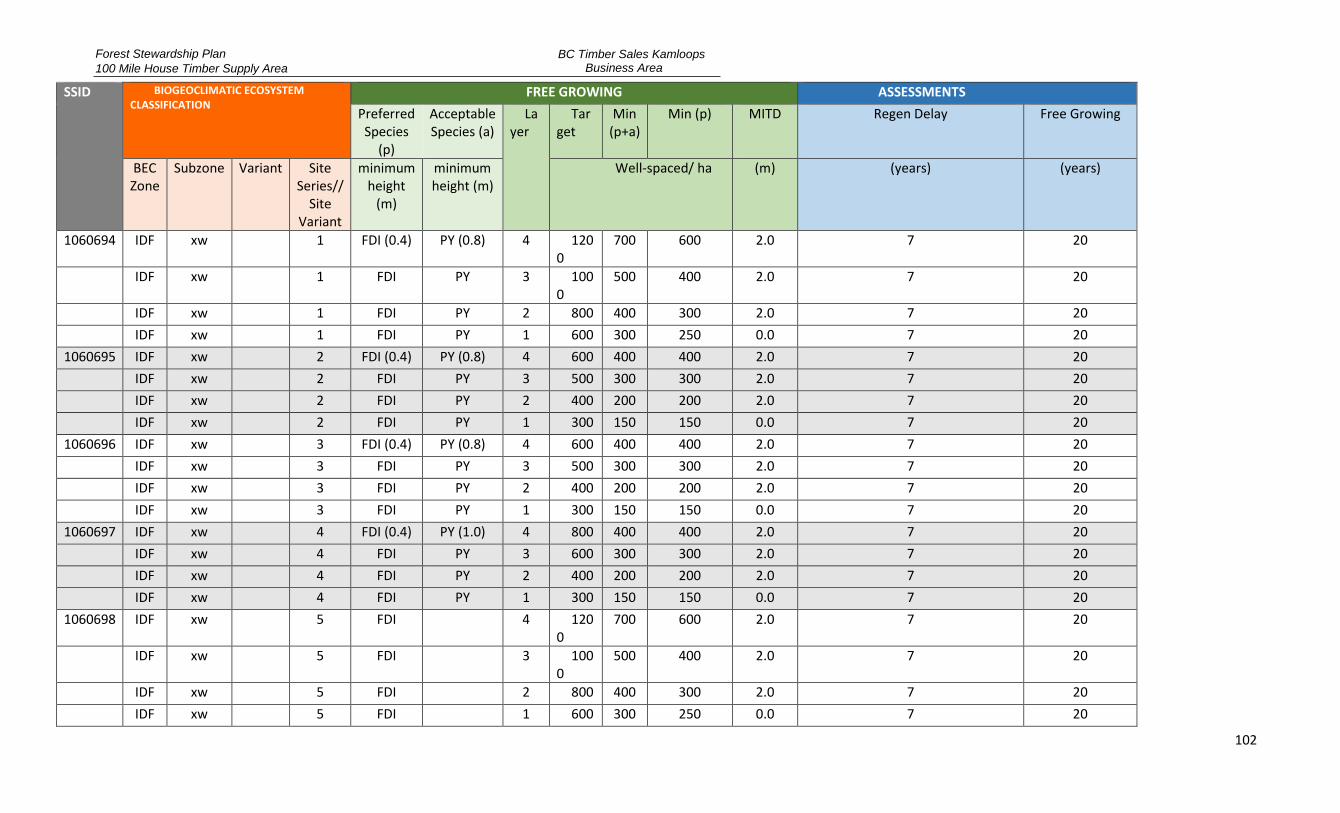
Forest Stewardship Plan
100 Mile House Timber Supply Area
BC Timber Sales Kamloops Business Area
102
SSID BIOGEOCLIMATIC ECOSYSTEM CLASSIFICATION
FREE GROWING ASSESSMENTS
Preferred Species
(p)
Acceptable Species (a)
Layer
Target
Min (p+a)
Min (p) MITD Regen Delay Free Growing
BEC Zone
Subzone Variant Site Series//
Site Variant
minimum height
(m)
minimum height (m)
Well-spaced/ ha (m) (years) (years)
1060694 IDF xw
1 FDI (0.4) PY (0.8) 4 1200
700 600 2.0 7 20
IDF xw
1 FDI PY 3 100
0 500 400 2.0 7 20
IDF xw 1 FDI PY 2 800 400 300 2.0 7 20
IDF xw 1 FDI PY 1 600 300 250 0.0 7 20
1060695 IDF xw 2 FDI (0.4) PY (0.8) 4 600 400 400 2.0 7 20
IDF xw 2 FDI PY 3 500 300 300 2.0 7 20
IDF xw 2 FDI PY 2 400 200 200 2.0 7 20
IDF xw 2 FDI PY 1 300 150 150 0.0 7 20
1060696 IDF xw 3 FDI (0.4) PY (0.8) 4 600 400 400 2.0 7 20
IDF xw 3 FDI PY 3 500 300 300 2.0 7 20
IDF xw 3 FDI PY 2 400 200 200 2.0 7 20
IDF xw 3 FDI PY 1 300 150 150 0.0 7 20
1060697 IDF xw 4 FDI (0.4) PY (1.0) 4 800 400 400 2.0 7 20
IDF xw 4 FDI PY 3 600 300 300 2.0 7 20
IDF xw 4 FDI PY 2 400 200 200 2.0 7 20
IDF xw 4 FDI PY 1 300 150 150 0.0 7 20
1060698 IDF xw
5 FDI
4 1200
700 600 2.0 7 20
IDF xw
5 FDI
3 100
0 500 400 2.0 7 20
IDF xw 5 FDI 2 800 400 300 2.0 7 20
IDF xw 5 FDI 1 600 300 250 0.0 7 20

Forest Stewardship Plan
100 Mile House Timber Supply Area
BC Timber Sales Kamloops Business Area
103
SSID BIOGEOCLIMATIC ECOSYSTEM CLASSIFICATION
FREE GROWING ASSESSMENTS
Preferred Species
(p)
Acceptable Species (a)
Layer
Target
Min (p+a)
Min (p) MITD Regen Delay Free Growing
BEC Zone
Subzone Variant Site Series//
Site Variant
minimum height
(m)
minimum height (m)
Well-spaced/ ha (m) (years) (years)
1060699 IDF xw
6 FDI (0.4) SX (0.6)
4 120
0 700 600 2.0 7 20
IDF xw
6 FDI
3 100
0 500 400 2.0 7 20
IDF xw 6 FDI 2 800 400 300 2.0 7 20
IDF xw 6 FDI 1 600 300 250 0.0 7 20
1060700 IDF xw
7 FDI (0.4) SX (0.6)
4 100
0 500 400 2.0 7 20
IDF xw 7 FDI SX 3 800 400 300 2.0 7 20
IDF xw 7 FDI SX 2 600 300 250 2.0 7 20
IDF xw 7 FDI SX 1 400 200 200 0.0 7 20
1060701 MS xk
1 FDI (0.8) PLI (0.8)
BL (0.8) LW (1.4)
4 1200
700 600 2.0 7 20
MS xk
1 FDI PLI BL LW 3 100
0 500 400 2.0 7 20
MS xk 1 FDI PLI BL LW 2 800 400 300 2.0 7 20
MS xk 1 FDI PLI BL LW 1 600 300 250 0.0 7 20
1060702 MS xk
2 FDI PLI SX (0.6) BL (0.6)
4 1000
500 400 2.0 7 20
MS xk 2 FDI PLI SX BL 3 800 400 300 2.0 7 20
MS xk 2 FDI PLI SX BL 2 600 300 250 2.0 7 20
MS xk 2 FDI PLI SX BL 1 400 200 200 0.0 7 20
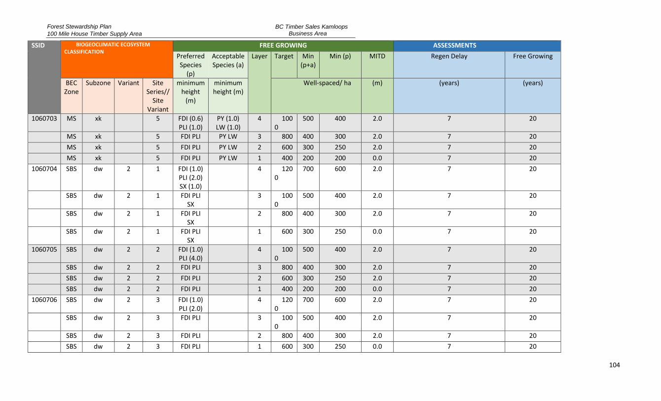
Forest Stewardship Plan
100 Mile House Timber Supply Area
BC Timber Sales Kamloops Business Area
104
SSID BIOGEOCLIMATIC ECOSYSTEM CLASSIFICATION
FREE GROWING ASSESSMENTS
Preferred Species
(p)
Acceptable Species (a)
Layer Target Min (p+a)
Min (p) MITD Regen Delay Free Growing
BEC Zone
Subzone Variant Site Series//
Site Variant
minimum height
(m)
minimum height (m)
Well-spaced/ ha (m) (years) (years)
1060703 MS xk
5 FDI (0.6) PLI (1.0)
PY (1.0) LW (1.0)
4 1000
500 400 2.0 7 20
MS xk 5 FDI PLI PY LW 3 800 400 300 2.0 7 20
MS xk 5 FDI PLI PY LW 2 600 300 250 2.0 7 20
MS xk 5 FDI PLI PY LW 1 400 200 200 0.0 7 20
1060704 SBS dw 2 1 FDI (1.0) PLI (2.0) SX (1.0)
4 1200
700 600 2.0 7 20
SBS dw 2 1 FDI PLI
SX
3 1000
500 400 2.0 7 20
SBS dw 2 1 FDI PLI
SX
2 800 400 300 2.0 7 20
SBS dw 2 1 FDI PLI SX
1 600 300 250 0.0 7 20
1060705 SBS dw 2 2 FDI (1.0) PLI (4.0)
4 100
0 500 400 2.0 7 20
SBS dw 2 2 FDI PLI 3 800 400 300 2.0 7 20
SBS dw 2 2 FDI PLI 2 600 300 250 2.0 7 20
SBS dw 2 2 FDI PLI 1 400 200 200 0.0 7 20
1060706 SBS dw 2 3 FDI (1.0) PLI (2.0)
4 120
0 700 600 2.0 7 20
SBS dw 2 3 FDI PLI
3 100
0 500 400 2.0 7 20
SBS dw 2 3 FDI PLI 2 800 400 300 2.0 7 20
SBS dw 2 3 FDI PLI 1 600 300 250 0.0 7 20

Forest Stewardship Plan
100 Mile House Timber Supply Area
BC Timber Sales Kamloops Business Area
105
SSID BIOGEOCLIMATIC ECOSYSTEM CLASSIFICATION
FREE GROWING ASSESSMENTS
Preferred Species
(p)
Acceptable Species (a)
Layer Target Min (p+a)
Min (p) MITD Regen Delay Free Growing
BEC Zone
Subzone Variant Site Series//
Site Variant
minimum height
(m)
minimum height (m)
Well-spaced/ ha (m) (years) (years)
1060707 SBS dw 2 4 FDI (1.0) PLI (2.0)
4 120
0 700 600 2.0 7 20
SBS dw 2 4 FDI PLI
3 100
0 500 400 2.0 7 20
SBS dw 2 4 FDI PLI 2 800 400 300 2.0 7 20
SBS dw 2 4 FDI PLI 1 600 300 250 0.0 7 20
1060708 SBS dw 2 5 FDI (1.0) PLI (2.0) SX (1.0)
4 1200
700 600 2.0 7 20
SBS dw 2 5 FDI PLI
SX
3 1000
500 400 2.0 7 20
SBS dw 2 5 FDI PLI
SX
2 800 400 300 2.0 7 20
SBS dw 2 5 FDI PLI SX
1 600 300 250 0.0 7 20
1060709 SBS dw 2 6 FDI (1.0) PLI (2.0) SX (1.0)
4 1200
700 600 2.0 7 20
SBS dw 2 6 FDI PLI
SX
3 1000
500 400 2.0 7 20
SBS dw 2 6 FDI PLI
SX
2 800 400 300 2.0 7 20
SBS dw 2 6 FDI PLI SX
1 600 300 250 0.0 7 20

Forest Stewardship Plan 100 Mile House District
BC Timber Sales Kamloops Business Area
106
7 Appendices
7.1 APPENDIX A – STOCKING STANDARDS
Section 44(1) of the FPPR applies to all areas harvested under the FSP except where exempted from the requirement of Section 29(1) or (2) of FRPA.
The stocking standards specified in Table 16 and Table 17 and its addendum shall apply to areas harvested under the FSP. These stocking standards may also be applied to areas harvested under a previous FSP or Forest Development Plan. The stocking standards approved under this FSP will apply to an area harvested under a previous plan when the stocking standard identification number applicable to a Standard Unit (SU) is submitted to RESULTS.
7.1.1 General Standards
7.1.1.1 Crop Tree Assessment
Regeneration and free growing surveys will be conducted under the oversight of a Forest Professional and/or Accredited Surveyor. Survey methodologies and tree acceptability criteria are as specified in the Resources Practices Branch, Silviculture Survey Procedures Manual and the FS660- Silviculture Survey Reference field card, as amended from time to time, unless specified or varied through provisions of this FSP.
7.1.1.2 Site Identification for the Purpose of Determining Stocking Standard
When determining the appropriate stocking standard in Table 16 and Table 17, site identification will be completed based on the procedures and site descriptions contained in the Land Management Handbook 39 (1997) – A Field Guide to the Forest Site Identification and Interpretation for the Cariboo Forest Region, as amended from time-to-time. For biogeoclimatic subzones that are not contained in the Cariboo Region guide Handbook Number 23 (1990) – A Guide to the Site Identification and Interpretation for the Kamloops Forest Region, as amended from time-to-time, shall be used.
7.1.1.3 District Policies that May Apply
Unless otherwise specified in this FSP, where a District approves a policy that varies the standards or procedure described in the Resource Practices Branch, Silviculture Survey Procedures Manual, the policy may be applied in the applicable District at the discretion of the obligation holder.
7.1.1.4 Deviation from Potential Survey Methodology to Assess Stocking Levels
1. Where harvesting on a SU having even aged stocking standards has resulted in partial cutting as a result of:
a) forest health management; or, b) where retention of crop trees is required to achieve a result or strategy in the FSP to address
an objective set by government, 2. The deviation from potential (DFP) survey methodology may be used to assess compliance with stocking standards provided:
a) the stratum contains between five (5) and twenty (20) m2/ha of residual basal area in stems ≥ 12.5 cm dbh, of preferred and/or acceptable species;
b) the stratum is greater than 1 ha in size; and, c) the SU is not being managed to uneven-aged standards.
3. Where the DFP survey methodology is used to the applicable stocking standard in Table 16 and Table 17 with regard to preferred and acceptable species, minimum tree heights, MITD, stocking
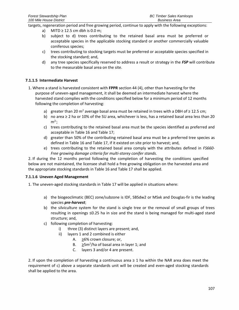
Forest Stewardship Plan 100 Mile House District
BC Timber Sales Kamloops Business Area
107
targets, regeneration period and free growing period, continue to apply with the following exceptions: a) MITD ≥ 12.5 cm dbh is 0.0 m; b) subject to d) trees contributing to the retained basal area must be preferred or
acceptable species in the applicable stocking standard or another commercially valuable coniferous species;
c) trees contributing to stocking targets must be preferred or acceptable species specified in the stocking standard; and,
d) any tree species specifically reserved to address a result or strategy in the FSP will contribute to the measurable basal area on the site.
7.1.1.5 Intermediate Harvest
1. Where a stand is harvested consistent with FPPR section 44 (4), other than harvesting for the purpose of uneven-aged management, it shall be deemed an intermediate harvest where the harvested stand complies with the conditions specified below for a minimum period of 12 months following the completion of harvesting:
a) greater than 20 m2 average basal area must be retained in trees with a DBH of ≥ 12.5 cm; b) no area ≥ 2 ha or 10% of the SU area, whichever is less, has a retained basal area less than 20
m2;; c) trees contributing to the retained basal area must be the species identified as preferred and
acceptable in Table 16 and Table 17; d) greater than 50% of the contributing retained basal area must be a preferred tree species as
defined in Table 16 and Table 17, if it existed on site prior to harvest; and, e) trees contributing to the retained basal area comply with the attributes defined in FS660-
Free growing damage criteria for multi-storey conifer stands. 2. If during the 12 months period following the completion of harvesting the conditions specified below are not maintained, the licensee shall hold a free growing obligation on the harvested area and the appropriate stocking standards in Table 16 and Table 17 shall be applied.
7.1.1.6 Uneven Aged Management
1. The uneven-aged stocking standards in Table 17 will be applied in situations where:
a) the biogeoclimatic (BEC) zone/subzone is IDF, SBSdw2 or MSxk and Douglas-fir is the leading
species pre-harvest; b) the silviculture system for the stand is single tree or the removal of small groups of trees
resulting in openings ≤0.25 ha in size and the stand is being managed for multi-aged stand structure; and,
c) following completion of harvesting: i) three (3) distinct layers are present; and, ii) layers 1 and 2 combined is either
A. ≥6% crown closure; or, B. ≥5m2/ha of basal area in layer 1; and C. layers 3 and/or 4 are present.
2. If upon the completion of harvesting a continuous area ≥ 1 ha within the NAR area does meet the requirement of c) above a separate standards unit will be created and even-aged stocking standards shall be applied to the area.

Forest Stewardship Plan 100 Mile House District
BC Timber Sales Kamloops Business Area
108
7.1.1.7 Conversion of Multi-Story Douglas-Fir Stand to Even Aged Management Following a Wildfire
Where a SU or a portion thereof is impacted by a wildfire to the extent that the conditions specified in Section 5(c) “Uneven Aged Management” are no longer met, the impacted portion shall be defined as a separate SU and even-aged stocking standards shall be applied to the area.
7.1.1.8 Mixed Wood Stocking Standards
1. A mixed wood stocking standard may only be applied in situations where:
a) the net merchantable cruise volume is greater than 30% net deciduous; b) the merchantable deciduous volume will be utilized; and, c) the pre-harvest objective specified in the site plan is to manage the SU for mixed wood
timber values. 2. Broadleaf forest health free growing criteria are as specified in the FS660- Silviculture Survey
Reference field card. 3. The applicable stocking standard in Table 16 and Table 17 for a SU shall be converted to a mixed
wood stocking standard based on Table 18. Broadleaf species contained in a mixed wood stocking standard shall be considered preferred species.
Table 18 - Conversion Table for Conifer Standards to Mixed Wood Standards
Target
from
Conifer
Standar
ds
Species
Target
Stocki
ng
(well-
spaced
/ha)
Minimum Stocking Standards
(well-spaced/ha)
Minimum Height
at Free Growing
(m) Rege
n
Dela
y
(yrs)
Latest
Free
Growin
g (yrs)
Min.
Preferred
&
Acceptable
at RD &
FG
Min.
Preferred
&
Acceptable
at RD &
FG
Min.
FG
Conife
rs
Dec. Con.
400 As defined by a
productive,
reliable and
feasible
regeneration
option (footnote
“a”) in Reference
Guide for FDP
Stocking
Standards
400 200 200 200 2.0
From
Table 13
for
applicable
site series
7 20
600 800 500 400 400 2.0 7 20
1000 1200 700 600 400 2.0 7 20
1200 1600 1000 800 600 2.0 7 20
4. Where mixed wood standards are applied, black cottonwood, trembling aspen, and common
paper birch trees not tallied as well-spaced or free-growing trees will be considered “competing vegetation” for the purpose of assessing the free growing status of the coniferous crop trees, unless Variation from General Standard 13) Standard for the Reduction of Weevil Damage is applied.
7.1.1.9 Broadleaf Stocking Standards
1. Broadleaf stocking standards may only be applied in situations where: a) the net merchantable cruise volume is greater than 70% net deciduous; b) the merchantable deciduous volume will be utilized; and, c) the pre-harvest objective specified in the site plans is to manage the SU for broadleaf timber
value. 2. Broadleaf forest health free growing criteria are as specified in the FS660- Silviculture Survey
Reference field card. 3. The applicable stocking standard in Table 16 and Table 17 for a SU shall be converted to a broadleaf stocking based on Table 19. Broadleaf species contained in the broadleaf stocking standards

Forest Stewardship Plan 100 Mile House District
BC Timber Sales Kamloops Business Area
109
shall be considered preferred species.
Table 19 - Conversion Table for Conifer Standards to Broadleaf Standards
Target
from
Conifer
Standar
ds
Species
Targe
t
Stocki
ng
(well-
space
d/ha)
Minimum Stocking Standards
(well-spaced/ha)
Minimum Height
at Free Growing
(m) Regen
Delay
(yrs)
Latest
Free
Growin
g (yrs)
Min.
Preferred
&
Acceptabl
e at RD &
FG
Min.
Preferred
&
Acceptabl
e at RD &
FG
Min.
FG
Conif
ers
Dec. Con.
400 As defined by a
productive,
reliable and
feasible
regeneration
option
(footnote “a”)
in Reference
Guide for FDP
Stocking
Standards
600 400 400 n/a 2.0
From
Table
13 for
applicab
le site
series
7 20
600 1000 500 400 n/a 2.0 7 20
1000 1600 1000 800 n/a 2.0 7 20
1200 2000 1200 1000 n/a 2.0 7 20
7.1.1.10 Brush Competition
1. Where specified in the site plan as leave trees, layers one (≥ 12.5 cm dbh), black cottonwood, trembling aspen, and birch trees, retained at the time of harvest are not considered competing vegetation at the time of the free growing assessment of coniferous crop trees.
2. Black cottonwood, trembling aspen and birch trees, and shrubs species being managed to achieve an objective, result or strategy of the FSP as specified in the site plan, are not considered competing vegetation at the time of free growing evaluation of coniferous crop trees.
3. Trembling aspen, black cottonwood, birch, willow, and alder are not considered competing brush when conducting a free growing survey within 5 m of a S4, S5, and S6 streams and all wetlands greater than 0.25 ha in the ICH and ESSF BEC zones, and within 10 m, of S4, S5, and S6 streams, and all wetlands greater than 0.25 ha in all other BEC zones.
4. Where a brushing treatment has been undertaken, and a visual buffer is required to achieve a result or strategy, aspen, cottonwood, birch, willow and alder will not be considered competing brush when conducting a free growing where the survey plots fall within the buffer.
5. For the purposes of free growing assessments in the SBPS BEC zone scrub birch will be considered non-competing when assessing the free growing status of crop trees.
6. Where the uneven-aged stocking standard applicable to a site specifies a minimum free growing height of 0.4 m for Douglas-fir, snowberry, soopalallie, common juniper, vaciniums sp. Saskatoon, birch-leafed spirea, herbaceous vegetation, and grasses are not considered competing vegetation at the time of free growing evaluation of the well-spaced Douglas-fir.
7. Where required to assess the free growing status of a crop tree the conifer to brush ratio shall be 125% for the ESSF, IDF and MS biogeoclimatic zones, and 150% in the ICH, SBPS SBS biogeoclimatic zones.
7.1.1.11 Lodgepole Pine Dwarf Mistletoe
In SUs where lodgepole pine is the only preferred species, when assessing the free growing status of a well-spaced lodgepole pine crop tree in regard to its proximity to mistletoe infected over topping pine

Forest Stewardship Plan 100 Mile House District
BC Timber Sales Kamloops Business Area
110
stems, only stems located within the NAR portion of the block being surveyed will be considered overtopping stems. Therefore, well-spaced lodgepole pine trees that do not have visible evidence of mistletoe infection remain eligible as potential free growing trees regardless of their proximity or height relative to visibly infected stems that are located outside of the NAR.
7.1.1.12 Retained Mistletoe Infected Lodgepole Pine to Address a Result or Strategy
Where lodgepole pine stems are retained consistent with the South Chilcotin Stewardship Plan, FSP Objectives for Moose (5.5.4.1), and Grizzly Bear (5.5.2.1), for the purpose of visual screening, or those portions of a cutblock within 500 meters of a HVMWMZ or Moose Management Unit, or where specifically required by a result or strategy in the FSP; the free growing damage criteria for even-aged coniferous trees as specified in the FS 660 field card, with regard to dwarf mistletoe, will not apply to retained lodgepole pine and subsequent lodgepole pine regeneration, provided that the portion of the block where pine are retained as a visual screen or to achieve a result or strategy in the FSP.
7.1.1.13 Limitations on the Use of Larch
The use of western larch must be consistent with the Chief Forester’s Standards for Seed Use, as amended from time to time (i.e., western larch restricted to 10% of planting program on an annual basis). Despite western larch being listed as an acceptable species in Table 16 and Table 17 for various biogeoclimatic subzones/site series, western larch shall only be considered an acceptable species where it is established consistent with the LW1 an LW2 seed planning zones. Larch shall not be considered preferred or acceptable in mule deer winter range (MDWR).
7.1.1.14 Limitations on the Use of White Pine
The use of white pine is restricted to rust resistant seedlots. Despite white pine’s inclusion in a stocking standard, where white pine is planted outside of an “A” Class seed planning zone for white pine the seedlings are considered to be non-compliant with the Chief Forester’s Standard for Seed Use.
7.1.1.15 Enhanced Stocking Standards
Enhanced stocking standards contained in the Table 16 and Table 17 can be applied at the discretion of the obligation holder.
7.1.1.16 Maximum Density Limits at Free Growing
The maximum allowable density at the time of free growing declaration: for pine leading strata where pine is ≥ 80 percent of the inventory, the maximum density is 25,000 countable conifers per hectare; for all other species and mixed pine stands where pine is less than 80% of the inventory the maximum density is 10,000 countable stems per hectare; and, for SUs to which uneven-aged stocking standards apply, the maximum density of stems in layers 3 is 1,000 stems per hectare. Where salvage harvesting has occurred following a wildfire disturbance the free growing obligation holder is exempt from clauses a) and b) above.
7.1.2 Variations from General Standards
A Forest Professional may vary the stocking standard listed in Table 16 and Table 17 as defined below in the following situations and circumstances:

Forest Stewardship Plan 100 Mile House District
BC Timber Sales Kamloops Business Area
111
7.1.2.1 Multiple Years to Harvest a SU
When harvesting occurs over multiple years on a SU with a 4-years regeneration delay, regeneration delay may be extended to 4 years after the start of the last harvest entry to a maximum of 7 years from the initial disturbance date. The late free growing date will be 20 years from the harvest date of the initial harvest entry.
7.1.2.2 Seven Year Regeneration Delay
Within 3 years following harvest commencement, and where based on a post-harvest field assessment, if a portion of a SU with a 4 year regeneration delay is planned to be regenerated by natural regeneration or direct seeding, the area being managed for natural regeneration or direct seeding may be defined as a separate standards unit with regeneration delay period of 7 years.
7.1.2.3 Changes to Milestones Due to Damage Caused by Wildfire
Where any portion of a standards unit larger than 1 ha is disturbed by wildfire such that the SU is left Not Satisfactorily Restocked (NSR) according to the currently approved stocking standard then:
a) a new disturbance shall be reported for that opening; b) the NSR portion of the original standards unit may be defined as a new standards unit; and, c) the appropriate stocking standards from Table 16 and Table 17 shall apply to the disturbed
area with the exception that; i) if the Regeneration Delay period has not elapsed, then Regeneration Delay and Late
Free Growing shall be calculated from the new disturbance date; or ii) if the Regeneration Delay period has elapsed, then a new Regeneration Delay period
will not apply and only Late Free Growing shall be calculated from the new disturbance date.
7.1.2.4 Pine as a Preferred Species in IDF Subzones
Where in the IDF biogeoclimatic zone an area is being managed with an uneven-aged silviculture system and the pre-harvest gross volume is greater than 40% lodgepole pine, and lodgepole pine is an acceptable species in Table 16 and Table 17 for the applicable site series, lodgepole pine may be elevated to a preferred species to a maximum of 50% of the well-spaced stems.
7.1.2.5 Spruce as a Preferred Species in IDF Subzones
Where in the IDF biogeoclimatic zone the pre-harvest gross volume is greater than 40% spruce, and spruce is an acceptable species in Table 16 and Table 17 for the applicable site series, spruce may be elevated to a preferred species to a maximum of 50% of well-spaced stems.
7.1.2.6 Reduced MITD
The MITD for a SU may be varied from the standard defined in Table 16 and Table 17 in the following situations and circumstances:
a) where mechanical site preparation, other than slash piling, has been undertaken to create microsites prior to planting the MITD can be reduced to 1.6 m;
b) on slopes ≥20% in the ESSF BEC zone where protected microsites are critical for successful reforestation due to snow creep, MITD may be reduced to 1.0 m where the SU has been planted to target density or greater;
c) where based on a silviculture survey a SU or portion thereof which has previously been planted has failed to maintain minimum stocking densities, due to the impacts of cattle or horses, the affected area maybe designated as a separate SU. In the newly designated SU the MITD may be reduced to 1.0 m if planting will be completed;

Forest Stewardship Plan 100 Mile House District
BC Timber Sales Kamloops Business Area
112
d) for areas that are identified and mapped as a root disease polygon, which may include up to a 30 m buffer, a separate SU may be created and the MITD may be reduced to 1.6 m where a stump avoidance strategy is employed to manage root disease;
e) where salvage harvesting has been undertaken in the IDF biogeoclimatic zone following a stand initiating wildfire, which is defined as having a level of disturbance such that the stand is NSR prior to salvage harvesting, and where the objective is to restore Douglas-fir and even-aged management is required, the MITD for Douglas-fir may be reduced to 0.5 m. The reduced MITD shall apply to the distance between natural or planted Douglas-fir stems and any other preferred or acceptable crop tree species. The MITD between non-Douglas-fir crop tree species (e.g., pine to pine) remains as specified in Table 16 and Table 17; and,
f) on rocky sites where a plantability survey has determined that the target stocking cannot be achieved due to the presence of rock when assessed at the applicable MITD, the MITD may be reduced to 1.6 m.
7.1.2.7 Grizzly Bear Habitat
Where consistent with a result and/or strategy in the FSP and prescribed in a site plan pre-harvest, a clumped tree distribution is required for the management of grizzle bear habitat, the target density, minimum preferred and acceptable and minimum preferred values in the stocking standards in Table 16 and Table 17 shall be modified by the factor of 0.67. For example, a stocking standard of 1000/500/400 shall become 670/335/268. The MITD shall be 1.0 m and maximum density of countable conifers shall be 4000/ha. The site plan must prescribe the number of trees in a cluster, the number of clusters/hectare and the spacing between clusters.
7.1.2.8 GAR Consistency
Where stocking standards included in this FSP conflict with the management objectives/direction of an Order under the GAR, the stocking standards will be varied to the extent that they do not conflict with the management objectives/direction of the applicable GAR order.
7.1.2.9 Benchmark Grassland Standards
Areas harvested within the identified Cariboo-Chilcotin Grassland Strategy benchmark area shall have no regeneration or free growing obligation.
7.1.2.10 Bighorn Sheep Management Area Standards
For SUs located within the identified Churn Creek Big Horn Sheep Migration Corridor stocking standards may be varied to the extent recommended in writing by a FLNRO&RD Habitat Biologist.
7.1.2.11 Standard for the Reduction of Weevil Damage
If, a) there is an active white pine weevil (Pissodes strobe) population on the block or an adjacent
managed opening as evidence by the presence of weevil damaged trees; and, b) the spruce trees being assessed are of acceptable vigor and form and meet all other
acceptability criteria (i.e., preferred or acceptable species, minimum height, MITD), then for the purpose of assessing the free growing status of spruce crop tree , all deciduous vegetation shall be assessed as non-competing brush.
7.1.2.12 Variations to Preferred or Acceptable Species
The preferred and/or acceptable species in the stocking standards in Table 16 and Table 17 may be varied
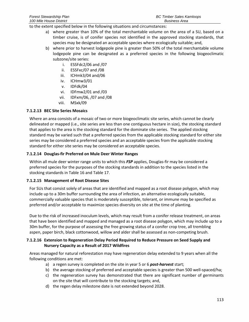
Forest Stewardship Plan 100 Mile House District
BC Timber Sales Kamloops Business Area
113
to the extent specified below in the following situations and circumstances: a) where greater than 10% of the total merchantable volume on the area of a SU, based on a
timber cruise, is of conifer species not identified in the approved stocking standards, that species may be designated an acceptable species where ecologically suitable; and,
b) where prior to harvest lodgepole pine is greater than 50% of the total merchantable volume lodgepole pine can be designated as a preferred species in the following biogeoclimatic subzone/site series:
i. ESSFdc2/06 and /07 ii. ESSFxc/07 and /08
iii. ICHmk3/04 and/06 iv. ICHmw3/01 v. IDFdk/04
vi. IDFmw2/01 and /03 vii. IDFxm/06, /07 and /08
viii. MSxk/09
7.1.2.13 BEC Site Series Mosaics
Where an area consists of a mosaic of two or more biogeoclimatic site series, which cannot be clearly delineated or mapped (i.e., site series are less than one contiguous hectare in size), the stocking standard that applies to the area is the stocking standard for the dominate site series. The applied stocking standard may be varied such that a preferred species from the applicable stocking standard for either site series may be considered a preferred species and an acceptable species from the applicable stocking standard for either site series may be considered an acceptable species.
7.1.2.14 Douglas-fir Preferred on Mule Deer Winter Ranges
Within all mule deer winter range units to which this FSP applies, Douglas-fir may be considered a preferred species for the purposes of the stocking standards in addition to the species listed in the stocking standards in Table 16 and Table 17.
7.1.2.15 Management of Root Disease Sites
For SUs that consist solely of areas that are identified and mapped as a root disease polygon, which may include up to a 30m buffer surrounding the area of infection, an alternative ecologically suitable, commercially valuable species that is moderately susceptible, tolerant, or immune may be specified as preferred and/or acceptable to maximize species diversity on site at the time of planting. Due to the risk of increased inoculum levels, which may result from a conifer release treatment, on areas that have been identified and mapped and managed as a root disease polygon, which may include up to a 30m buffer, for the purpose of assessing the free growing status of a conifer crop tree, all trembling aspen, paper birch, black cottonwood, willow and alder shall be assessed as non-competing brush.
7.1.2.16 Extension to Regeneration Delay Period Required to Reduce Pressure on Seed Supply and Nursery Capacity as a Result of 2017 Wildfires
Areas managed for natural reforestation may have regeneration delay extended to 9 years when all the following conditions are met:
a) a regen survey is completed on the site in year 5 or 6 post-harvest start; b) the average stocking of preferred and acceptable species is greater than 500 well-spaced/ha; c) the regeneration survey has demonstrated that there are significant number of germinants
on the site that will contribute to the stocking targets; and, d) the regen delay milestone date is not extended beyond 2028.

Forest Stewardship Plan 100 Mile House District
BC Timber Sales Kamloops Business Area
114
7.1.2.17 Extension to Regeneration Delay Period When Standards Units with a 4 Year Regen Delay are a Minor Component of the Cut Block
1. Where a cut block: a) is located in either the ESSFxv1, ESSFxv2, MSxv, SBPSdc, SBPSmc, SBPSmk or SBPSxc
biogeoclimatic subzones; b) contains SU’s that have a 4 year regeneration delay and 7 years regeneration delay periods;
and, c) less than 25 percent (25%) of the NAR area of the cut block has a 4 year regeneration delay
period, 2. all standards within the block may be managed with a 7 year regen delay period.
7.1.2.18 Intermediate Harvest Stands
Where harvesting is deemed to be an intermediate harvest, as per clause General Condition Clause 6.1.5 Intermediate Harvest of this document, the applicable stocking standard in Table 16 and Table 17may be varied such that:
a) There shall be no regeneration objective, and b) The minimum basal area objective shall be set at 20m2/ha or greater.
7.1.2.19 Uneven Aged Management Required to Achieve a Result or Strategy in the FSP
Where required to achieve a result or strategy in the FSP any Douglas-fir leading stand may be managed for uneven aged stand structure. The stocking standard that shall apply will be the applicable even aged stocking standard, based on biogeoclimatic subzone and site series, from Table 16 and Table 17 as modified consistent with Table 20 below.
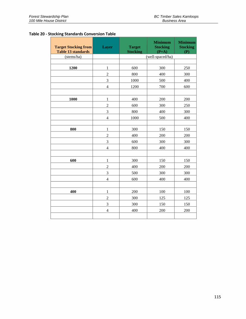
Forest Stewardship Plan 100 Mile House District
BC Timber Sales Kamloops Business Area
115
Table 20 - Stocking Standards Conversion Table
Target Stocking from
Table 13 standards
Layer
Target
Stocking
Minimum
Stocking
(P+A)
Minimum
Stocking
(P) (stems/ha) (well-spaced/ha)
1200 1 600 300 250
2 800 400 300
3 1000 500 400
4 1200 700 600
1000 1 400 200 200
2 600 300 250
3 800 400 300
4 1000 500 400
800 1 300 150 150
2 400 200 200
3 600 300 300
4 800 400 400
600 1 300 150 150
2 400 200 200
3 500 300 300
4 600 400 400
400 1 200 100 100
2 300 125 125
3 300 150 150
4 400 200 200
Forest Stewardship Plan 100 Mile House District
BC Timber Sales Kamloops Business Area
116
7.2 APPENDIX B – FSP MAPS
Table 21 - Summary of FSP Maps
Reference Map
Number Map Reference
Key 1:200,000 FDU Key Map for the TSA dated October 24, 2016
1-12 1:50,000 FSP maps dated April 27, 2017

Forest Stewardship Plan 100 Mile House District
BC Timber Sales Kamloops Business Area
117
7.3 APPENDIX C – WILDLIFE TREE RETENTION TARGETS
Table 22 - Wildlife Tree Retention Targets

Forest Stewardship Plan 100 Mile House District
BC Timber Sales Kamloops Business Area
118

Forest Stewardship Plan 100 Mile House District
BC Timber Sales Kamloops Business Area
119
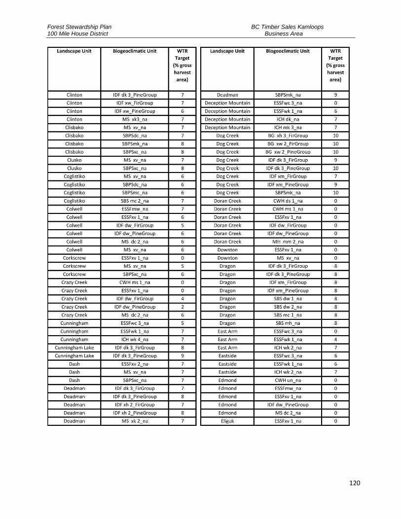
Forest Stewardship Plan 100 Mile House District
BC Timber Sales Kamloops Business Area
120

Forest Stewardship Plan 100 Mile House District
BC Timber Sales Kamloops Business Area
121

Forest Stewardship Plan 100 Mile House District
BC Timber Sales Kamloops Business Area
122

Forest Stewardship Plan 100 Mile House District
BC Timber Sales Kamloops Business Area
123
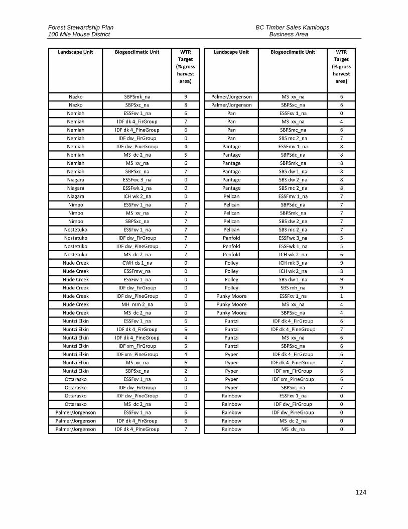
Forest Stewardship Plan 100 Mile House District
BC Timber Sales Kamloops Business Area
124

Forest Stewardship Plan 100 Mile House District
BC Timber Sales Kamloops Business Area
125

Forest Stewardship Plan 100 Mile House District
BC Timber Sales Kamloops Business Area
126

Forest Stewardship Plan 100 Mile House District
BC Timber Sales Kamloops Business Area
127
7.4 APPENDIX D – OBJECTIVES FOR RECREATION SITES, TRAILS AND INTERPRETIVE FOREST SITES
ORG UNIT CODE
ORG UNIT NAME
FOREST FILE ID
PROJECT NAME
PROJECT TYPE TOTAL AREA (ha)
TOTAL TRAIL
LENGTH (km)
OBJECTIVE DESCRIPTION
DMH
100 Mile House Natural
Resource District
REC99085
Lang Lake Interpretive Forest Trail
IF - Interpretive
Forest 0 2.083
DMH
100 Mile House Natural
Resource District
REC106914
Porcupine Creek Trails
RTR - Recreation
Trail 0 5.803
DMH
100 Mile House Natural
Resource District
REC160138
MICA MOUNTAIN RECREATION TRAIL
RTR - Recreation
Trail 0 6.811
DMH
100 Mile House Natural
Resource District
REC166903
99 MILE CROSS-COUNTRY SKI TRAILS
RTR - Recreation
Trail 0 42.057
Remarks: Previously REC2972 / REC2792; Objectives: 1999/01/31 - The objectives are to manage the 99 Mile recreation site for a semi primitive recreation experience. Opportunities for cross country skiing and cross country running will be provided at the site. Gravel road access for two wheel drive vehicles will be maintained to the trail head.
DMH
100 Mile House Natural
Resource District
REC169743
Howard Lake Trail
RTR - Recreation
Trail 0 7.622
Objectives: 2003/08/05 The objective is to manage the Howard Lake Trail for a semi-primitive recreation experience. The trail will provide opportunities for hiking, horseback riding, and mountain biking. Gravel road access will be maintained for two-wheel drive vehicles to the trailhead from May to early October.
DMH
100 Mile House Natural
Resource District
REC169746
Fly Lake Trail RTR -
Recreation Trail
0 9.899

Forest Stewardship Plan 100 Mile House District
BC Timber Sales Kamloops Business Area
128
ORG UNIT CODE
ORG UNIT NAME
FOREST FILE ID
PROJECT NAME
PROJECT TYPE TOTAL AREA (ha)
TOTAL TRAIL
LENGTH (km)
OBJECTIVE DESCRIPTION
DMH
100 Mile House Natural
Resource District
REC184097
Bridge Lake Ice Caves Recreation Trail
RTR - Recreation
Trail 0 2.359
DMH
100 Mile House Natural
Resource District
REC191942
Greeny Lake Trail
RTR - Recreation
Trail 0 3.360
DMH
100 Mile House Natural
Resource District
REC202921
TOMMY ARCHIE LAKE TRAIL
RTR - Recreation
Trail 0 1.444
The objective is to manage the Tommy Archie Lake Recreation Trail for a semi-primitive recreation experience. The trail is mostly suited to hiking, with some potential for horseback riding and mountain biking. Gravel road access will be maintained for two-wheel drive vehicles to the trailhead from May to early October.
DMH
100 Mile House Natural
Resource District
REC230315
Clinton Trail RTR -
Recreation Trail
0 2.590
DMH
100 Mile House Natural
Resource District
REC230522
99 Mile Snowshoe Trails
RTR - Recreation
Trail 0 6.532
DMH
100 Mile House Natural
Resource District
REC240475
Earle Lake Trails
RTR - Recreation
Trail 0 2.661
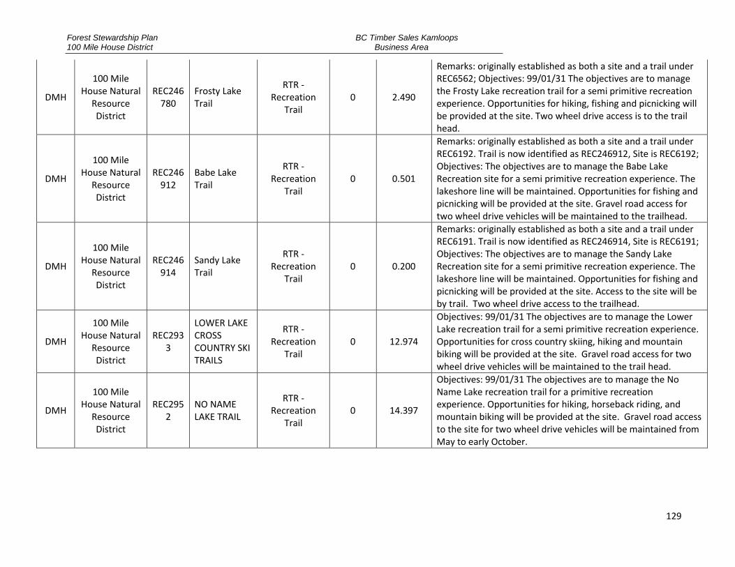
Forest Stewardship Plan 100 Mile House District
BC Timber Sales Kamloops Business Area
129
DMH
100 Mile House Natural
Resource District
REC246780
Frosty Lake Trail
RTR - Recreation
Trail 0 2.490
Remarks: originally established as both a site and a trail under REC6562; Objectives: 99/01/31 The objectives are to manage the Frosty Lake recreation trail for a semi primitive recreation experience. Opportunities for hiking, fishing and picnicking will be provided at the site. Two wheel drive access is to the trail head.
DMH
100 Mile House Natural
Resource District
REC246912
Babe Lake Trail
RTR - Recreation
Trail 0 0.501
Remarks: originally established as both a site and a trail under REC6192. Trail is now identified as REC246912, Site is REC6192; Objectives: The objectives are to manage the Babe Lake Recreation site for a semi primitive recreation experience. The lakeshore line will be maintained. Opportunities for fishing and picnicking will be provided at the site. Gravel road access for two wheel drive vehicles will be maintained to the trailhead.
DMH
100 Mile House Natural
Resource District
REC246914
Sandy Lake Trail
RTR - Recreation
Trail 0 0.200
Remarks: originally established as both a site and a trail under REC6191. Trail is now identified as REC246914, Site is REC6191; Objectives: The objectives are to manage the Sandy Lake Recreation site for a semi primitive recreation experience. The lakeshore line will be maintained. Opportunities for fishing and picnicking will be provided at the site. Access to the site will be by trail. Two wheel drive access to the trailhead.
DMH
100 Mile House Natural
Resource District
REC2933
LOWER LAKE CROSS COUNTRY SKI TRAILS
RTR - Recreation
Trail 0 12.974
Objectives: 99/01/31 The objectives are to manage the Lower Lake recreation trail for a semi primitive recreation experience. Opportunities for cross country skiing, hiking and mountain biking will be provided at the site. Gravel road access for two wheel drive vehicles will be maintained to the trail head.
DMH
100 Mile House Natural
Resource District
REC2952
NO NAME LAKE TRAIL
RTR - Recreation
Trail 0 14.397
Objectives: 99/01/31 The objectives are to manage the No Name Lake recreation trail for a primitive recreation experience. Opportunities for hiking, horseback riding, and mountain biking will be provided at the site. Gravel road access to the site for two wheel drive vehicles will be maintained from May to early October.
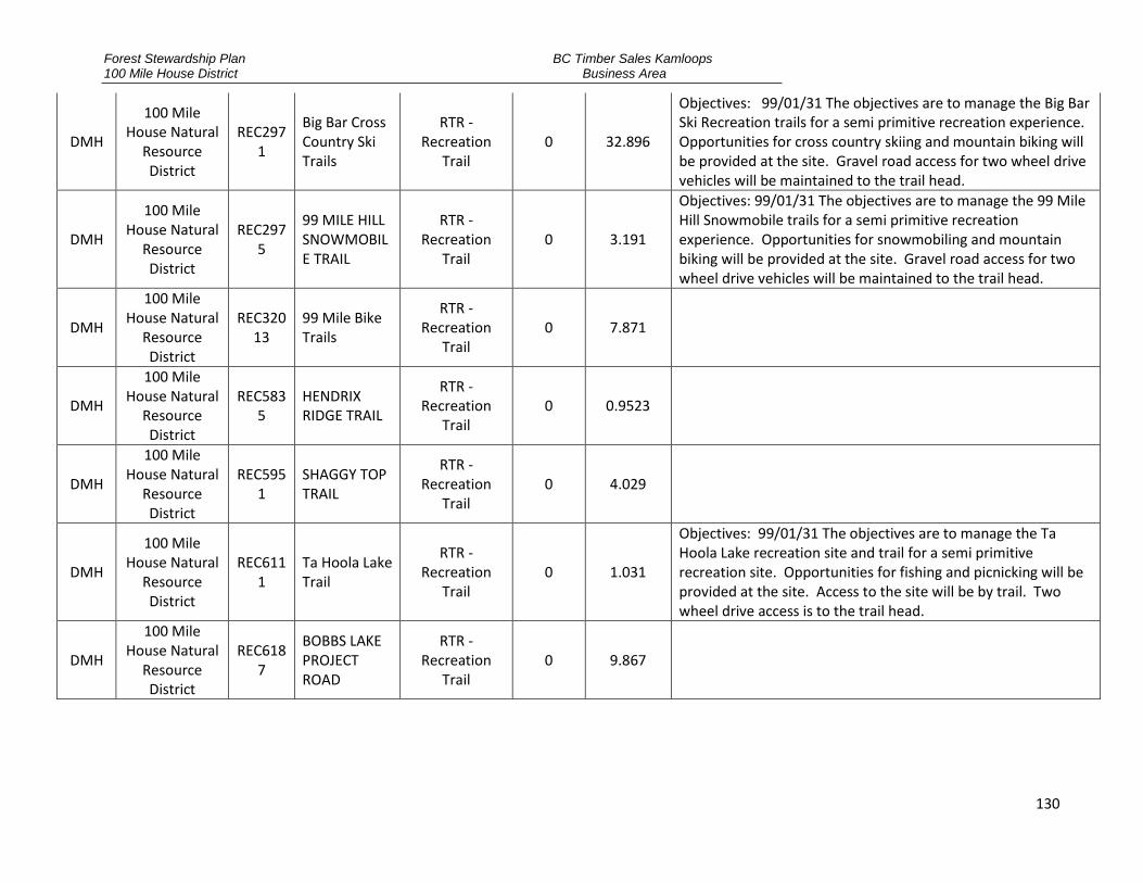
Forest Stewardship Plan 100 Mile House District
BC Timber Sales Kamloops Business Area
130
DMH
100 Mile House Natural
Resource District
REC2971
Big Bar Cross Country Ski Trails
RTR - Recreation
Trail 0 32.896
Objectives: 99/01/31 The objectives are to manage the Big Bar Ski Recreation trails for a semi primitive recreation experience. Opportunities for cross country skiing and mountain biking will be provided at the site. Gravel road access for two wheel drive vehicles will be maintained to the trail head.
DMH
100 Mile House Natural
Resource District
REC2975
99 MILE HILL SNOWMOBILE TRAIL
RTR - Recreation
Trail 0 3.191
Objectives: 99/01/31 The objectives are to manage the 99 Mile Hill Snowmobile trails for a semi primitive recreation experience. Opportunities for snowmobiling and mountain biking will be provided at the site. Gravel road access for two wheel drive vehicles will be maintained to the trail head.
DMH
100 Mile House Natural
Resource District
REC32013
99 Mile Bike Trails
RTR - Recreation
Trail 0 7.871
DMH
100 Mile House Natural
Resource District
REC5835
HENDRIX RIDGE TRAIL
RTR - Recreation
Trail 0 0.9523
DMH
100 Mile House Natural
Resource District
REC5951
SHAGGY TOP TRAIL
RTR - Recreation
Trail 0 4.029
DMH
100 Mile House Natural
Resource District
REC6111
Ta Hoola Lake Trail
RTR - Recreation
Trail 0 1.031
Objectives: 99/01/31 The objectives are to manage the Ta Hoola Lake recreation site and trail for a semi primitive recreation site. Opportunities for fishing and picnicking will be provided at the site. Access to the site will be by trail. Two wheel drive access is to the trail head.
DMH
100 Mile House Natural
Resource District
REC6187
BOBBS LAKE PROJECT ROAD
RTR - Recreation
Trail 0 9.867

Forest Stewardship Plan 100 Mile House District
BC Timber Sales Kamloops Business Area
131
DMH
100 Mile House Natural
Resource District
REC6246
GREEN LAKE SNOWMOBILE TRAIL
RTR - Recreation
Trail 0 155.83
Objectives: 99/01/31 The objectives are to manage the Green Lake snowmobile recreation trail for snowmobile trail. Opportunities for travel on foot, mountain bike or all-terrain vehicles will also be possible. Access is provided to the trail head.
DMH
100 Mile House Natural
Resource District
REC6560
RONALD LAKE
RTR - Recreation
Trail 0 1.5174
Objectives: 99/01/07 The objectives are to manage the Ronald Lake recreation trail for a semi primitive recreation experience. Opportunities for hiking, fishing and picnicking will be provided at the site. Two wheel drive access is to the trail head.
DMH
100 Mile House Natural
Resource District
REC6586
100 MILE SNOWMOBILE TRAIL
RTR - Recreation
Trail 0 35.711
DMH
100 Mile House Natural
Resource District
REC6612
FAWN CREEK RECREATION TRAILS
RTR - Recreation
Trail 0 18.141
DMH
100 Mile House Natural
Resource District
REC6894
GOLD RUSH SNOWMOBILE TRAIL
RTR - Recreation
Trail 0 243.505
The objectives of the Gold Rush Snowmobile Trail are to maintain the trail for a semi-primitive recreation experience; to maintain the integrity of the 75 m right-of-way of the trail, to protect both visual aesthetic values of the trail, as well as, to preserve favorable snow conditions during winter months. Integrity should be consistent with objectives in place for the CCLUP “buffered trails” (85 percent basal retention). Portions of the Gold Rush Recreation Trail are currently identified as CCLUP “buffered trails”; The Gold Rush Recreation Trail has sections of trail that are on “non-status roads”, these sections will continue to have recreation trail as their primary use; The trail currently consists of two recreation project numbers: REC 6894 in the 100 Mile House Natural Resource District; and REC 6895 in the Cariboo-Chilcotin Natural Resource District, linking together to form a continuous route from 70 Mile House to Horsefly.

Forest Stewardship Plan 100 Mile House District
BC Timber Sales Kamloops Business Area
132
DMH
100 Mile House Natural
Resource District
REC6897
70 Mile Green Lake Trail
RTR - Recreation
Trail 0 23.999
Objectives: 2003/08/05 The objective is to manage the 70 Mile Green Lake Recreation Trail for a mainly semi-primitive recreation experience. The primary use of the trail will be for snowmobiling during the winter. Other potential uses are mountain biking and horseback riding in other seasons. The trail head is accessed via two-wheel drive public road.
DMH
100 Mile House Natural
Resource District
REC6898
INTERLAKES (FAWN LAKE) TRAIL
RTR - Recreation
Trail 0 25.913
Objectives: 2003/08/05 The objective is to manage the Interlakes Recreation Trail for a mainly semi-primitive recreation experience. The trail provides opportunities for hiking, horseback riding, skiing, and mountain biking. The trailhead is accessed via two-wheel drive public road.
DMH
100 Mile House Natural
Resource District
REC6905
Windy Mountain Trail
RTR - Recreation
Trail 0 12.7221
Objectives: 2003/8/05 The objective is to manage the Windy Mountain Recreation Trail for a semi-primitive recreation experience. The primary use of the trail will be for snowmobiling during the winter. Other potential uses are mountain biking and horseback riding in other seasons. The trailhead commences from a two-wheel drive FSR road. Snow removal is not guaranteed to the trailhead in the winter.
DMH
100 Mile House Natural
Resource District
REC6906
UNDEFINED (part of Perimeter Trail, north of Tahoola)
RTR - Recreation
Trail 0 16.365
DMH
100 Mile House Natural
Resource District
REC6907
Brown Creek Trail
RTR - Recreation
Trail 0 17.0399
Objectives: 2003/08/05 The objective is to manage the Brown Creek Recreation Trail for a semi-primitive recreation experience. The primary use of the trail will be for snowmobiling during the winter. Other potential uses are mountain biking and horseback riding in other seasons. The trailhead commences from a two-wheel drive FSR road. Snow removal is not guaranteed to the trailhead in the winter.

Forest Stewardship Plan 100 Mile House District
BC Timber Sales Kamloops Business Area
133
DMH
100 Mile House Natural
Resource District
REC6908
Hammer Lake Trail
RTR - Recreation
Trail 0 16.842
Objectives: 2003/08/05 The objective is to manage the Hammer Lake Recreation Trail for a semi-primitive recreation experience. The primary use of the trail will be for snowmobiling during the winter. Other potential uses are mountain biking and horseback riding in other seasons. The trail head commences from a two-wheel drive FSR road. Snow removal is not guaranteed to the trail head in the winter.
DMH
100 Mile House Natural
Resource District
REC6909
Joe Ross Trail RTR -
Recreation Trail
0 5.0633
Objectives: 2003/08/05 The objective is to manage the Joe Ross Recreation Trail for a semi-primitive recreation experience. The primary use of the trail will be for snowmobiling during the winter. Other potential uses are mountain biking and horseback riding in other seasons. The trail commences on a two-wheel drive FSR road. Snow removal is not guaranteed to the start of the trail in the winter.
DMH
100 Mile House Natural
Resource District
REC6951
INTERLAKES SNOWMOBILE TRAIL
RTR - Recreation
Trail 0 40.141
DMH
100 Mile House Natural
Resource District
REC98238
HALLER AND GRINDER RECREATION TRAILS
RTR - Recreation
Trail 0 35.668
DMH
100 Mile House Natural
Resource District
REC98243
Hendrix Creek Falls Trail
RTR - Recreation
Trail 0 0.569
DMH
100 Mile House Natural
Resource District
REC98279
Perimeter Trail
RTR - Recreation
Trail 0 6.188

Forest Stewardship Plan 100 Mile House District
BC Timber Sales Kamloops Business Area
134
DMH
100 Mile House Natural
Resource District
REC99061
Preacher Lake Trail
RTR - Recreation
Trail 0 1.127
Remarks: Previously established under REC5730; Objectives: 99/01/31 The objectives are to manage the Preacher Lake recreation trail for a semi primitive recreation experience. The lake shoreline will be maintained. Opportunities for fishing and picnicking will be provided. Access to the site will be by trail. Two wheel drive access is to the trail head.
DMH
100 Mile House Natural
Resource District
REC131914
MICA MOUNTAIN TRAILHEAD
SIT - Recreation
Site 0.344 0
DMH
100 Mile House Natural
Resource District
REC154998
99 Mile Bike Trails Parking Lot
SIT - Recreation
Site 0.387 0
DMH
100 Mile House Natural
Resource District
REC160875
BEGBIE LOOKOUT
SIT - Recreation
Site 2.744 0
DMH
100 Mile House Natural
Resource District
REC160877
Porcupine Creek Trailhead
SIT - Recreation
Site 0.886 0
DMH
100 Mile House Natural
Resource District
REC166942
99 Mile Parking Oval
SIT - Recreation
Site 0.382 0
DMH
100 Mile House Natural
Resource District
REC1794
VIDETTE LAKE SIT -
Recreation Site
2.166 0
Remarks: Additional details exist on file 2970 (archived). Site is in DMH but managed by DKA. Objectives: 99/01/07 The objectives are to manage the Vidette Lake recreation site for a roaded recreation experience. The lakeshore line will be maintained. Opportunities for fishing, camping and picnicking will be provided at the site. Gravel road access for two wheel drive vehicles will be maintained from May to early October.

Forest Stewardship Plan 100 Mile House District
BC Timber Sales Kamloops Business Area
135
DMH
100 Mile House Natural
Resource District
REC181688
Beanstalk Cabin
SIT - Recreation
Site 0.2000 0
DMH
100 Mile House Natural
Resource District
REC181690
McGregor Cabin
SIT - Recreation
Site 0.2000 0
DMH
100 Mile House Natural
Resource District
REC202869
HALLER TRAILHEAD
SIT - Recreation
Site 0.4130 0
DMH
100 Mile House Natural
Resource District
REC202871
GRINDER TRAILHEAD
SIT - Recreation
Site 0.3560 0
DMH
100 Mile House Natural
Resource District
REC204409
GUSTAFSEN LAKE
SIT - Recreation
Site 1.2970 0
DMH
100 Mile House Natural
Resource District
REC205666
Jesmond Fire Lookout
SIT - Recreation
Site 0.4000 0
DMH
100 Mile House Natural
Resource District
REC230971
Sulphurous Lake
SIT - Recreation
Site 1.5850 0
DMH
100 Mile House Natural
Resource District
REC2501
SHARPE LAKE WEST
SIT - Recreation
Site 11.215 0
Objectives: 99/01/31 The objectives are to manage the Sharpe Lake Recreation Site for a roaded recreation experience. The lakeshore line will be maintained. Opportunities for picnicking, fishing, and camping will be provided at the site. Gravel road access to the site will be maintained for two wheel drive vehicles from May to early October.

Forest Stewardship Plan 100 Mile House District
BC Timber Sales Kamloops Business Area
136
DMH
100 Mile House Natural
Resource District
REC2502
LITTLE SCOT LAKE
SIT - Recreation
Site 6.32 0
Objectives: 99/01/31 The objectives are to manage the Little Scot Lake Recreation Site for a roaded recreation experience. The lakeshore line and coniferous features will be maintained. A trail circumnavigating the lake will also be maintained. Opportunities for picnicking, fishing, camping, and hiking will be provided at the site. Gravel road access to the site will be maintained for two wheel drive vehicles from May to early October.
DMH
100 Mile House Natural
Resource District
REC2503
SCOT LAKE NORTH
SIT - Recreation
Site 4.533 0
Objectives: 99/01/31 The objectives are to manage the Scot Lake North Recreation Site for a roaded recreation experience. The lakeshore line will be maintained. Opportunities for picnicking, fishing and camping will be provided at the site. Gravel road access to the site will be maintained for two wheel drive vehicles from May to early October.
DMH
100 Mile House Natural
Resource District
REC2504
HAMMER LAKE NORTH
SIT - Recreation
Site 1.474 0
Objectives: 99/01/31 The objectives are to manage the Hammer Lake North Site for a roaded recreation experience. The lakeshore line will be maintained. Opportunities for picnicking, fishing and camping will be provided at the site. The lake is restricted to electric motors. Gravel road access to the site will be maintained for two wheel drive vehicles from May to early October.
DMH
100 Mile House Natural
Resource District
REC2505
BONAPARTE LAKE
SIT - Recreation
Site 8.811 0
Objectives: 99/01/31 The objectives are to manage the Bonaparte Lake Recreation Site for a roaded recreation experience. A boat launching area is available at this site. Opportunities for picnicking, camping, and fishing will be provided at the site. Gravel road access for two wheel drive to the site will be maintained from May to early October.
DMH
100 Mile House Natural
Resource District
REC2508
HIHIUM LAKE SOUTH
SIT - Recreation
Site 3.318 0
Objectives: 99/01/31 The objectives are to manage the Hihium Lake South Recreation Site for a roaded recreation experience. The lakeshore line and coniferous vegetation features will be maintained. Opportunities for fishing, picnicking and camping will be provided at the site. Gravel road access for two wheel drive to the site will be maintained from May to early October.
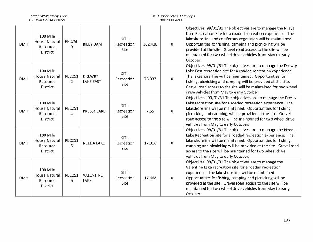
Forest Stewardship Plan 100 Mile House District
BC Timber Sales Kamloops Business Area
137
DMH
100 Mile House Natural
Resource District
REC2509
RILEY DAM SIT -
Recreation Site
162.418 0
Objectives: 99/01/31 The objectives are to manage the Rileys Dam Recreation Site for a roaded recreation experience. The lakeshore line and coniferous vegetation will be maintained. Opportunities for fishing, camping and picnicking will be provided at the site. Gravel road access to the site will be maintained for two wheel drive vehicles from May to early October.
DMH
100 Mile House Natural
Resource District
REC2512
DREWRY LAKE EAST
SIT - Recreation
Site 78.337 0
Objectives: 99/01/31 The objectives are to manage the Drewry Lake East recreation site for a roaded recreation experience. The lakeshore line will be maintained. Opportunities for fishing, picnicking and camping will be provided at the site. Gravel road access to the site will be maintained for two wheel drive vehicles from May to early October.
DMH
100 Mile House Natural
Resource District
REC2514
PRESSY LAKE SIT -
Recreation Site
7.55 0
Objectives: 99/01/31 The objectives are to manage the Pressy Lake recreation site for a roaded recreation experience. The lakeshore line will be maintained. Opportunities for fishing, picnicking and camping, will be provided at the site. Gravel road access to the site will be maintained for two wheel drive vehicles from May to early October.
DMH
100 Mile House Natural
Resource District
REC2515
NEEDA LAKE SIT -
Recreation Site
17.316 0
Objectives: 99/01/31 The objectives are to manage the Needa Lake Recreation site for a roaded recreation experience. The lake shoreline will be maintained. Opportunities for fishing, camping and picnicking will be provided at the site. Gravel road access to the site will be maintained for two wheel drive vehicles from May to early October.
DMH
100 Mile House Natural
Resource District
REC2516
VALENTINE LAKE
SIT - Recreation
Site 17.668 0
Objectives: 99/01/31 The objectives are to manage the Valentine Lake recreation site for a roaded recreation experience. The lakeshore line will be maintained. Opportunities for fishing, camping and picnicking will be provided at the site. Gravel road access to the site will be maintained for two wheel drive vehicles from May to early October.

Forest Stewardship Plan 100 Mile House District
BC Timber Sales Kamloops Business Area
138
DMH
100 Mile House Natural
Resource District
REC2517
CHRISTMAS LAKE
SIT - Recreation
Site 2.507 0
Objectives: 99/01/31 The objectives are to manage the Christmas Lake recreation site for a roaded recreation experience. The lakeshore and coniferous line will be maintained. Opportunities for fishing, camping and picnicking will be provided at the site. Gravel road access to the site will be maintained for two wheel drive vehicles from May to early October.
DMH
100 Mile House Natural
Resource District
REC2518
SUCCOUR LAKE
SIT - Recreation
Site 10.266 0
Objectives: 99/01/31 The objectives are to manage the Succour Lake recreation site for a roaded recreation experience. The lakeshore line will be maintained. Opportunities for fishing, camping and picnicking will be provided at the site. Gravel road access to the site will be maintained for two wheel drive vehicles from May to early October.
DMH
100 Mile House Natural
Resource District
REC2519
LOWER LAKE SIT -
Recreation Site
3.801 0
Objectives: 99/01/31 The objectives are to manage the Lower Lake recreation site for a roaded recreation experience. The lakeshore line will be maintained. Opportunities for fishing, camping and picnicking will be provided at the site. Gravel road access to the site will be maintained for two wheel drive vehicles from May to early October.
DMH
100 Mile House Natural
Resource District
REC2520
RAIL LAKE SIT -
Recreation Site
15.065 0
DMH
100 Mile House Natural
Resource District
REC2521
GREENLEE LAKE
SIT - Recreation
Site 32.085 0
DMH
100 Mile House Natural
Resource District
REC2522
GREENY LAKE NORTH
SIT - Recreation
Site 12.754 0
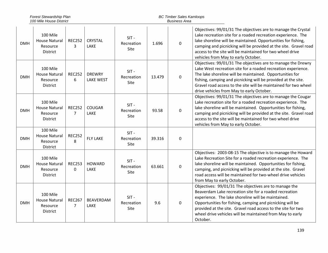
Forest Stewardship Plan 100 Mile House District
BC Timber Sales Kamloops Business Area
139
DMH
100 Mile House Natural
Resource District
REC2523
CRYSTAL LAKE
SIT - Recreation
Site 1.696 0
Objectives: 99/01/31 The objectives are to manage the Crystal Lake recreation site for a roaded recreation experience. The lake shoreline will be maintained. Opportunities for fishing, camping and picnicking will be provided at the site. Gravel road access to the site will be maintained for two wheel drive vehicles from May to early October.
DMH
100 Mile House Natural
Resource District
REC2526
DREWRY LAKE WEST
SIT - Recreation
Site 13.479 0
Objectives: 99/01/31 The objectives are to manage the Drewry Lake West recreation site for a roaded recreation experience. The lake shoreline will be maintained. Opportunities for fishing, camping and picnicking will be provided at the site. Gravel road access to the site will be maintained for two wheel drive vehicles from May to early October.
DMH
100 Mile House Natural
Resource District
REC2527
COUGAR LAKE
SIT - Recreation
Site 93.58 0
Objectives: 99/01/31 The objectives are to manage the Cougar Lake recreation site for a roaded recreation experience. The lake shoreline will be maintained. Opportunities for fishing, camping and picnicking will be provided at the site. Gravel road access to the site will be maintained for two wheel drive vehicles from May to early October.
DMH
100 Mile House Natural
Resource District
REC2528
FLY LAKE SIT -
Recreation Site
39.316 0
DMH
100 Mile House Natural
Resource District
REC2530
HOWARD LAKE
SIT - Recreation
Site 63.661 0
Objectives: 2003-08-15 The objective is to manage the Howard Lake Recreation Site for a roaded recreation experience. The lake shoreline will be maintained. Opportunities for fishing, camping, and picnicking will be provided at the site. Gravel road access will be maintained for two-wheel drive vehicles from May to early October.
DMH
100 Mile House Natural
Resource District
REC2677
BEAVERDAM LAKE
SIT - Recreation
Site 9.6 0
Objectives: 99/01/31 The objectives are to manage the Beaverdam Lake recreation site for a roaded recreation experience. The lake shoreline will be maintained. Opportunities for fishing, camping and picnicking will be provided at the site. Gravel road access to the site for two wheel drive vehicles will be maintained from May to early October.

Forest Stewardship Plan 100 Mile House District
BC Timber Sales Kamloops Business Area
140
DMH
100 Mile House Natural
Resource District
REC2699
BOWERS LAKE
SIT - Recreation
Site 26.652 0
Objectives: 99/01/31 The objectives are to manage the Bowers Lake recreation site for a semi primitive roaded recreation experience. The lake shoreline will be maintained. Opportunities for fishing, camping and picnicking will be provided at the site. Road access to the site for four wheel drive vehicles will be maintained from May to early October.
DMH
100 Mile House Natural
Resource District
REC2756
HELENA LAKE SIT -
Recreation Site
7.954 0
Objectives: 99/01/31 The objectives are to manage the Helena Lake recreation site for a roaded recreation experience. Opportunities for fishing, camping and picnicking will be provided at the site. Gravel road access to the site for two wheel drive vehicles will be maintained from May to early October.
DMH
100 Mile House Natural
Resource District
REC2782
LITTLE BIG BAR LAKE
SIT - Recreation
Site 12.503 0
Objectives: 99/01/31 The objectives are to manage the Little Big Bar recreation site for a roaded recreation experience. Opportunities for fishing, camping, horseback riding and picnicking will be provided at the site. The lake shoreline will be maintained. Gravel road access to the site for two wheel drive vehicles will be maintained from May to early October.
DMH
100 Mile House Natural
Resource District
REC2805
NEEDA LAKE WEST
SIT - Recreation
Site 16.009 0
Objectives: 99/01/31 - The objectives are to manage the Needa Lake recreation site for a roaded recreation experience. Opportunities for fishing and picnicking will be provided at the site. Access for four wheel drive vehicles will be maintained from May to early October.
DMH
100 Mile House Natural
Resource District
REC2931
MOOSE LAKE SIT -
Recreation Site
1.603 0
Objectives: 99/01/31 The objectives are to manage the Moose Lake recreation site for a roaded recreation experience. The lake shoreline will be maintained. Opportunities for fishing, camping and picnicking will be provided at the site. Gravel road access to the site for two wheel drive vehicles will be maintained from May to early October.
DMH
100 Mile House Natural
Resource District
REC2932
BONAPARTE RIVER SUICIDE CROSSING
SIT - Recreation
Site 16.8 0
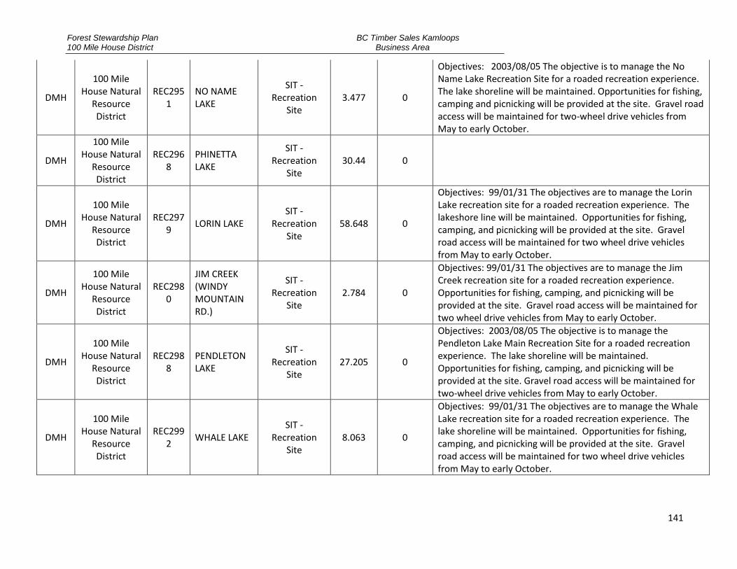
Forest Stewardship Plan 100 Mile House District
BC Timber Sales Kamloops Business Area
141
DMH
100 Mile House Natural
Resource District
REC2951
NO NAME LAKE
SIT - Recreation
Site 3.477 0
Objectives: 2003/08/05 The objective is to manage the No Name Lake Recreation Site for a roaded recreation experience. The lake shoreline will be maintained. Opportunities for fishing, camping and picnicking will be provided at the site. Gravel road access will be maintained for two-wheel drive vehicles from May to early October.
DMH
100 Mile House Natural
Resource District
REC2968
PHINETTA LAKE
SIT - Recreation
Site 30.44 0
DMH
100 Mile House Natural
Resource District
REC2979
LORIN LAKE SIT -
Recreation Site
58.648 0
Objectives: 99/01/31 The objectives are to manage the Lorin Lake recreation site for a roaded recreation experience. The lakeshore line will be maintained. Opportunities for fishing, camping, and picnicking will be provided at the site. Gravel road access will be maintained for two wheel drive vehicles from May to early October.
DMH
100 Mile House Natural
Resource District
REC2980
JIM CREEK (WINDY MOUNTAIN RD.)
SIT - Recreation
Site 2.784 0
Objectives: 99/01/31 The objectives are to manage the Jim Creek recreation site for a roaded recreation experience. Opportunities for fishing, camping, and picnicking will be provided at the site. Gravel road access will be maintained for two wheel drive vehicles from May to early October.
DMH
100 Mile House Natural
Resource District
REC2988
PENDLETON LAKE
SIT - Recreation
Site 27.205 0
Objectives: 2003/08/05 The objective is to manage the Pendleton Lake Main Recreation Site for a roaded recreation experience. The lake shoreline will be maintained. Opportunities for fishing, camping, and picnicking will be provided at the site. Gravel road access will be maintained for two-wheel drive vehicles from May to early October.
DMH
100 Mile House Natural
Resource District
REC2992
WHALE LAKE SIT -
Recreation Site
8.063 0
Objectives: 99/01/31 The objectives are to manage the Whale Lake recreation site for a roaded recreation experience. The lake shoreline will be maintained. Opportunities for fishing, camping, and picnicking will be provided at the site. Gravel road access will be maintained for two wheel drive vehicles from May to early October.

Forest Stewardship Plan 100 Mile House District
BC Timber Sales Kamloops Business Area
142
DMH
100 Mile House Natural
Resource District
REC2993
BOAR LAKE SIT -
Recreation Site
6.982 0
Objectives: 99/01/31 The objectives are to manage the Boar Lake recreation site for a roaded recreation experience. The lake shoreline will be maintained. Opportunities for fishing, camping, and picnicking will be provided at the site. Gravel road access will be maintained for two wheel drive vehicles from May to early October.
DMH
100 Mile House Natural
Resource District
REC2994
IRISH LAKE SIT -
Recreation Site
14.621 0
Objectives: 99/01/31 The objectives are to manage the Irish Lake recreation site for a roaded recreation experience. The lake shoreline will be maintained. Opportunities for fishing, camping, and picnicking will be provided at the site. Gravel road access will be maintained for two wheel drive vehicles from May to early October.
DMH
100 Mile House Natural
Resource District
REC2997
ROGER LAKE SIT -
Recreation Site
28.989 0
Objectives: 99/01/31 The objectives are to manage the Roger Lake recreation site for a semi primitive recreation experience. Opportunities for fishing, camping and picnicking will be provided at the site. Access for four wheel drive vehicles will be maintained from May to early October.
DMH
100 Mile House Natural
Resource District
REC2998
MERIDIAN LAKE
SIT - Recreation
Site 6.755 0
Objectives: 99/01/31 The objectives are to manage the Meridian Lake recreation site for a roaded recreation experience. The lake shoreline will be maintained. Opportunities for fishing, camping, and picnicking will be provided at the site. Gravel road access will be maintained for two wheel drive vehicles from May to early October.
DMH
100 Mile House Natural
Resource District
REC5730
PREACHER LAKE ISLAND
SIT - Recreation
Site 2.635 0
Objectives: 99/01/31 The objectives are to manage the Preacher Lake recreation trail for a semi primitive recreation experience. The lake shoreline will be maintained. Opportunities for fishing and picnicking will be provided. Access to the site will be by trail. Two wheel drive access is to the trail head.

Forest Stewardship Plan 100 Mile House District
BC Timber Sales Kamloops Business Area
143
DMH
100 Mile House Natural
Resource District
REC5948
BOG LAKE SIT -
Recreation Site
15.851 0
Objectives: 99/01/31 The objectives are to manage the Bog Lake recreation site for a roaded recreation experience. The lake shoreline will be maintained. Opportunities for fishing and picnicking will be provided at the site. If future use increases; camping will be provided. Gravel road access to the site will be maintained for two wheel drive vehicles from May to early October.
DMH
100 Mile House Natural
Resource District
REC5949
LASTCOURSE LAKE
SIT - Recreation
Site 62.073 0
Objectives: 99/01/31 The objectives are to manage the Lastcourse Lake recreation site for a roaded recreation experience. The lake shoreline and coniferous vegetation features will be maintained. Opportunities for fishing, camping and picnicking will be provided at the site. Gravel road access to the site will be maintained for two wheel drive vehicles from May to early October.
DMH
100 Mile House Natural
Resource District
REC5950
FRENCH LAKE SOUTH
SIT - Recreation
Site 27.935 0
Objectives: 99/01/31 The objectives are to manage the French Lake recreation site for a roaded recreation experience. The lake shoreline will be maintained. Opportunities for fishing, camping and picnicking will be provided at the site. Gravel road access to the site will be maintained for four wheel drive vehicles from May to early October.
DMH
100 Mile House Natural
Resource District
REC5960
PADDY LAKE SIT -
Recreation Site
6.319 0
Objectives: 99/01/31 The objectives are to manage the Paddy Lake recreation site for roaded recreation experience. The lake shoreline will be maintained. Opportunities for fishing, camping and picnicking will be provided at the site. Gravel road access to the site will be maintained for two wheel drive vehicles from May to early October.
DMH
100 Mile House Natural
Resource District
REC5962
TOMMY ARCHIE LAKE
SIT - Recreation
Site 4.812 0
The objective is to manage the Tommy Archie Lake Recreation Site for a semi-primitive recreation experience. The lake shoreline will be maintained. Opportunities for fishing, camping, and picnicking will be provided at the site. Access to the site will be by trail. Gravel road access will be maintained for two-wheel drive vehicles to the trailhead from May to early October.

Forest Stewardship Plan 100 Mile House District
BC Timber Sales Kamloops Business Area
144
DMH
100 Mile House Natural
Resource District
REC6041
TA HOOLA LAKE
SIT - Recreation
Site 60.015 0
Objectives: 99/01/31 The objectives are to manage the Ta Hoola Lake recreation site and trail for a semi primitive recreation site. Opportunities for fishing and picnicking will be provided at the site. Access to the site will be by trail. Two wheel drive access is to the trail head.
DMH
100 Mile House Natural
Resource District
REC6059
LAKE OF THE TREES
SIT - Recreation
Site 10.393 0
DMH
100 Mile House Natural
Resource District
REC6170
SNAG LAKE SIT -
Recreation Site
11.021 0
Objectives: 99/01/31 The objectives are to manage the Snag Lake recreation site for a roaded recreation site. The lake shoreline will be maintained. Opportunities for fishing, camping and picnicking will be provided at the site. Gravel road access to the site will be maintained for two wheel drive vehicles from May to early October.
DMH
100 Mile House Natural
Resource District
REC6174
JUDY LAKE SIT -
Recreation Site
2.235 0
Objectives: 99/01/31 The objectives are to manage the Judy Lake recreation site for a roaded recreation experience. The lake shoreline will be maintained. Opportunities for fishing and picnicking will be provided at the site. Gravel road access will be maintained for two wheel drive vehicles from May to early October.
DMH
100 Mile House Natural
Resource District
REC6175
EAST KING LAKE
SIT - Recreation
Site 4.179 0
Objectives: 99/01/31 The objectives are to manage the East King Lake recreation site for a semi primitive recreation experience. The lake shoreline will be maintained. Opportunities for fishing and picnicking will be provided at the site. Access for four wheel drive vehicles will be maintained from May to early October.
DMH
100 Mile House Natural
Resource District
REC6179
SUSAN LAKE SIT -
Recreation Site
7.004 0
Objectives: 99/01/07 The objectives are to manage the Susan Lake recreation site for a roaded recreation experience. The lakeshore line will be maintained. Opportunities for fishing, camping and picnicking will be provided at the site. Gravel road access will be maintained for two wheel drive vehicles from May to early October.

Forest Stewardship Plan 100 Mile House District
BC Timber Sales Kamloops Business Area
145
DMH
100 Mile House Natural
Resource District
REC6182
SPANISH LAKE
SIT - Recreation
Site 3.585 0
Objectives: 99/01/31 The objectives are to manage the Spanish lake recreation site for a semi primitive recreation experience. Opportunities for snowmobiling, picnicking and camping will be provided at the site. Gravel road access will be maintained for two wheel drive vehicles from May to early October. During the winter months; access is by snowmobile.
DMH
100 Mile House Natural
Resource District
REC6189
TINGLEY LAKE SIT -
Recreation Site
2.419 0
Objectives: 99/01/31 The objectives are to manage the Tingley Lake recreation site for a roaded recreation experience. The lake shoreline will be maintained. Opportunities for fishing and picnicking will be provided at the site. Gravel road access will be maintained for two wheel drive vehicles from May to early October.
DMH
100 Mile House Natural
Resource District
REC6191
SANDY LAKE SIT -
Recreation Site
1.422 0
Remarks: originally established as both a site and a trail under REC6191. Trail is now identified as REC246914, Site is REC6191; Objectives: The objectives are to manage the Sandy Lake Recreation site for a semi primitive recreation experience. The lakeshore line will be maintained. Opportunities for fishing and picnicking will be provided at the site. Access to the site will be by trail. Two wheel drive access to the trailhead.
DMH
100 Mile House Natural
Resource District
REC6192
BABE LAKE SIT -
Recreation Site
3.364 0
Remarks: originally established as both a site and a trail under REC6192. Trail is now identified as REC246912, Site is REC6192; Objectives: The objectives are to manage the Babe Lake Recreation site for a semi primitive recreation experience. The lakeshore line will be maintained. Opportunities for fishing and picnicking will be provided at the site. Gravel road access for two wheel drive vehicles will be maintained to the trailhead.
DMH
100 Mile House Natural
Resource District
REC6229
FISH LAKE SIT -
Recreation Site
4.62 0
Objectives: 99/01/31 The objectives are to manage the Fish Lake recreation site for a roaded recreation experience. The lakeshore line will be maintained. Opportunities for fishing and picnicking will be provided at the site. Access to the site for two wheel drive vehicles will be maintained from May to early October.
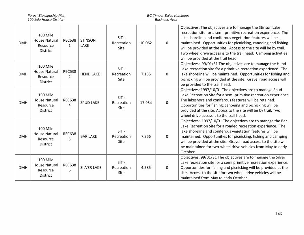
Forest Stewardship Plan 100 Mile House District
BC Timber Sales Kamloops Business Area
146
DMH
100 Mile House Natural
Resource District
REC6381
STINSON LAKE
SIT - Recreation
Site 10.062 0
Objectives: The objectives are to manage the Stinson Lake recreation site for a semi-primitive recreation experience. The lake shoreline and coniferous vegetation features will be maintained. Opportunities for picnicking, canoeing and fishing will be provided at the site. Access to the site will be by trail. Two wheel drive access is to the trail head. Camping activities will be provided at the trail head.
DMH
100 Mile House Natural
Resource District
REC6382
HEND LAKE SIT -
Recreation Site
7.155 0
Objectives: 99/01/31 The objectives are to manage the Hend Lake recreation site for a primitive recreation experience. The lake shoreline will be maintained. Opportunities for fishing and picnicking will be provided at the site. Gravel road access will be provided to the trail head.
DMH
100 Mile House Natural
Resource District
REC6384
SPUD LAKE SIT -
Recreation Site
17.954 0
Objectives: 1997/10/01 The objectives are to manage Spud Lake Recreation Site for a semi-primitive recreation experience. The lakeshore and coniferous features will be retained. Opportunities for fishing, canoeing and picnicking will be provided at the site. Access to the site will be by trail. Two wheel drive access is to the trail head.
DMH
100 Mile House Natural
Resource District
REC6385
BAR LAKE SIT -
Recreation Site
7.366 0
Objectives: 1997/10/01 The objectives are to manage the Bar Lake Recreation Site for a roaded recreation experience. The lake shoreline and coniferous vegetation features will be maintained. Opportunities for picnicking, fishing and camping will be provided at the site. Gravel road access to the site will be maintained for two-wheel drive vehicles from May to early October.
DMH
100 Mile House Natural
Resource District
REC6386
SILVER LAKE SIT -
Recreation Site
4.585 0
Objectives: 99/01/31 The objectives are to manage the Silver Lake recreation site for a semi primitive recreation experience. Opportunities for fishing and picnicking will be provided at the site. Access to the site for two wheel drive vehicles will be maintained from May to early October.

Forest Stewardship Plan 100 Mile House District
BC Timber Sales Kamloops Business Area
147
DMH
100 Mile House Natural
Resource District
REC6395
HUDSON BAY LAKE
SIT - Recreation
Site 14.855 0
Objectives: 99/01/31 The objectives are to manage the Lower Hudson Bay Lake recreation site for a roaded recreation experience. The lake shoreline will be maintained. Opportunities for camping, fishing and picnicking will be provided at the site. Gravel road access to the site will be provided for two wheel drive vehicles from May to early October.
DMH
100 Mile House Natural
Resource District
REC6396
LUNCH LAKE SIT -
Recreation Site
23.734 0
Objectives: 99/01/31 The objectives are to manage the Lunch Lake recreation site for a semi primitive recreation experience. The lake shoreline will be maintained. Opportunities for fishing and picnicking will be provided at the site. Access to the site will be maintained for four wheel drive vehicles from May to early October.
DMH
100 Mile House Natural
Resource District
REC6398
LITTLE SPECTACLE LAKE
SIT - Recreation
Site 7.887 0
Objectives: 1997/10/01 The objectives are to manage the Little Spectacle Lake Recreation Site for a semi-primitive recreation experience. Opportunities for picnicking, fishing and canoeing activities will be provided at the site. The lake shoreline and coniferous vegetation features will be retained. Access to the site will be by trail.
DMH
100 Mile House Natural
Resource District
REC6562
FROSTY LAKE SIT -
Recreation Site
3.215 0
Remarks: established as both a site and a trail; Objectives: 99/01/31 The objectives are to manage the Frosty Lake recreation trail for a semi primitive recreation experience. Opportunities for hiking, fishing and picnicking will be provided at the site. Two wheel drive access is to the trail head.
DMH
100 Mile House Natural
Resource District
REC6563
LITTLE FROSTY LAKE
SIT - Recreation
Site 2.243 0
Objectives: 99/01/31 The objectives are to manage the Little Frosty Lake recreation site for a semi primitive recreation experience. Opportunities for fishing and canoeing will be provided at the site. The lake shoreline will be retained. Access to the site will be by trail.
DMH
100 Mile House Natural
Resource District
REC6578
MICA MOUNTAIN
SIT - Recreation
Site
4596.843
0

Forest Stewardship Plan 100 Mile House District
BC Timber Sales Kamloops Business Area
148
DMH
100 Mile House Natural
Resource District
REC6697
LANG LAKE INTERPRETIVE TRAIL (PARKING AREA)
SIT - Recreation
Site 0.234 0
DMH
100 Mile House Natural
Resource District
REC98327
Pendletone Lake North
SIT - Recreation
Site 50.481 0
Objectives: 2003/08/05 The site is currently undeveloped. The objective for the future is to manage the Pendleton Lake North Recreation Site for a semi-primitive recreation experience. The lake shoreline will be maintained. The location is currently only accessible by water from the Pendleton Lake Main Recreation Site, or by snowmobile in the winter. Road access may be developed to the site in the future, providing a roaded recreation experience. The intent is for the site to provide opportunities for fishing, camping, and picnicking.
DMH
100 Mile House Natural
Resource District
REC98342
Pendleton Lake Little Cone
SIT - Recreation
Site 36.506 0
Objectives: 2003/08/05 The objective is to manage the Pendleton Lake Little Pendleton Cone Recreation Site for a semi-primitive recreation experience. The lake shoreline will be maintained. The intent is for the site to provide opportunities for fishing, camping, and picnicking. This site is accessed by water from the Pendleton Lake Main Recreation Site, or by snowmobile in the winter. Gravel road access to the Pendleton Lake Main Recreation Site will be maintained for two-wheel drive vehicles from May to early October.
DMH
100 Mile House Natural
Resource District
REC98344
Pendleton Lake East Island
SIT - Recreation
Site 5.977 0
Objectives: 2003/08/05 The objective is to manage the Pendleton Lake East Island Recreation Site for a semi-primitive recreation experience. The lake shoreline will be maintained. The site provides opportunities for fishing, camping, and picnicking. This site is accessed by water from the Pendleton Lake Main Recreation Site, or by snowmobile in the winter. Gravel road access to the Pendleton Lake Main Recreation Site will be maintained for two-wheel drive vehicles from May to early October.
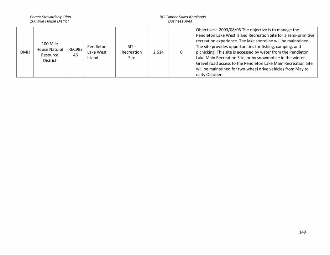
Forest Stewardship Plan 100 Mile House District
BC Timber Sales Kamloops Business Area
149
DMH
100 Mile House Natural
Resource District
REC98346
Pendleton Lake West Island
SIT - Recreation
Site 2.614 0
Objectives: 2003/08/05 The objective is to manage the Pendleton Lake West Island Recreation Site for a semi-primitive recreation experience. The lake shoreline will be maintained. The site provides opportunities for fishing, camping, and picnicking. This site is accessed by water from the Pendleton Lake Main Recreation Site, or by snowmobile in the winter. Gravel road access to the Pendleton Lake Main Recreation Site will be maintained for two-wheel drive vehicles from May to early October.
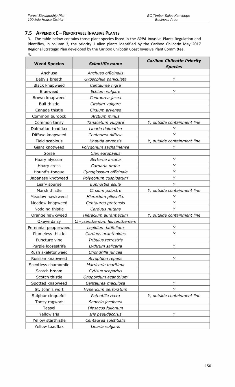
Forest Stewardship Plan 100 Mile House District
BC Timber Sales Kamloops Business Area
150
7.5 APPENDIX E – REPORTABLE INVASIVE PLANTS 3. The table below contains those plant species listed in the FRPA Invasive Plants Regulation and identifies, in column 3, the priority 1 alien plants identified by the Cariboo Chilcotin May 2017 Regional Strategic Plan developed by the Cariboo Chilcotin Coast Invasive Plant Committee. 4.
Weed Species Scientific name Cariboo Chilcotin Priority
Species
Anchusa Anchusa officinalis
Baby's breath Gypsophila paniculata Y
Black knapweed Centaurea nigra
Blueweed Echium vulgare Y
Brown knapweed Centaurea jacea
Bull thistle Cirsium vulgare
Canada thistle Cirsium arvense
Common burdock Arctium minus
Common tansy Tanacetum vulgare Y, outside containment line
Dalmatian toadflax Linaria dalmatica Y
Diffuse knapweed Centaurea diffusa Y
Field scabious Knautia arvensis Y, outside containment line
Giant knotweed Polygonum sachalinense Y
Gorse Ulex europaeus
Hoary alyssum Berteroa incana Y
Hoary cress Cardaria draba Y
Hound's-tongue Cynoglossum officinale Y
Japanese knotweed Polygonum cuspidatum Y
Leafy spurge Euphorbia esula Y
Marsh thistle Cirsium palustre Y, outside containment line
Meadow hawkweed Hieracium pilosella. Y
Meadow knapweed Centaurea pratensis Y
Nodding thistle Carduus nutans Y
Orange hawkweed Hieracium aurantiacum Y, outside containment line
Oxeye daisy Chrysanthemum leucanthemem
Perennial pepperweed Lepidium latifolium Y
Plumeless thistle Carduus acanthoides Y
Puncture vine Tribulus terrestris
Purple loosestrife Lythrum salicaria Y
Rush skeletonweed Chondrilla juncea
Russian knapweed Acroptilon repens Y
Scentless chamomile Matricaria maritima
Scotch broom Cytisus scoparius
Scotch thistle Onopordum acanthium
Spotted knapweed Centaurea maculosa Y
St. John's wort Hypericum perforatum Y
Sulphur cinquefoil Potentilla recta Y, outside containment line
Tansy ragwort Senecio jacobaea
Teasel Dipsacus fullonum
Yellow Iris Iris pseudacorus Y
Yellow starthistle Centaurea solstitialis
Yellow toadflax Linaria vulgaris