1.0 purpose and need 1.1 purpose of the proposed action · the purpose of the proposed action is to...
TRANSCRIPT

I‐55 at Weber Road Interchange Study Purpose and Need Report
1
1.0 PURPOSE AND NEED
1.1 Purpose of the Proposed ActionThe purpose of the proposed action is to provide an improved transportation facility in the Interstate 55
and Weber Road Interchange project study area. The specific needs to be addressed include safety,
operational, and capacity deficiencies.
1.2 Background
1.2.1 Project Study Area The project is located in DuPage Township in northwest Will County and is situated within the Villages
of Romeoville and Bolingbrook. The study area includes the Interstate 55 (I‐55) at Weber Road
interchange and ramps, and extends along I‐55 a half‐mile east and west of Weber Road (Figure 1).
The study also includes two (2) miles of Weber Road, from the northern intersection of Rodeo
Drive/119th Street to the southern intersection of Romeo Road/135th Street.
Figure 1: Project Study Area

I‐55 at Weber Road Interchange Study Purpose and Need Report
2
1.2.2 Interchange History The I‐55 at Weber Road interchange was built in 1990 in anticipation of growth in Will County and the
municipalities adjacent to the interchange. At that time, much of the area around Weber Road was
used for farming with a few residential subdivisions existing within the project study area. Will County
is one of the fastest growing counties in the nation; the population has increased from 357,313
residents in 1990 to 681,097 residents in 2008, nearly doubling in size in 18 years. The area around the
interchange has experienced similar growth, and land use has become more commercial/industrial in
nature.
1.2.3 Classification and Regional Context I‐55 is a full access controlled north‐south facility that serves local and regional traffic. I‐55 connects
Chicago and St. Louis and is a vital link in the transportation network of the Chicago Metropolitan Area
and Will County, moving over 125,000 vehicles per day (vpd) in the project study area. I‐55 and
Interstate 57 (I‐57), 25 miles east of the study area, are the only north/south Interstate facilities
between the Chicagoland area and downstate Illinois.
The section of I‐55 contained within the project study area is located along the diagonal stretch of
roadway that connects to Interstate 80 (I‐80) near Joliet and Interstate 355 (I‐355) in Bolingbrook
(Figure 2). I‐55 was widened from two to three lanes in each direction between I‐80 and Weber Road
in 2008. In addition to the interchange at Weber Road, this portion of I‐55 includes full interchanges at
I‐355 and IL Route 53 in Bolingbrook, U.S. Route 30 in Joliet, U.S. Route 52 and IL Route 59 in
Shorewood, I‐80 in Joliet, and a partial interchange at IL Route 126 in Plainfield. The Weber Road and
I‐55 interchange is located approximately three (3) miles southwest of the I‐55 and IL Route 53
interchange and two (2) miles northeast of the I‐55 at IL Route 126 interchange.
STUDY
AREA
Figure 2: Interchanges on I‐55

I‐55 at Weber Road Interchange Study Purpose and Need Report
3
The “Strategic Regional Arterial (SRA) Design Concept Report,” developed in 1994 by the Illinois
Department of Transportation (IDOT), outlined the SRA network of over 100 existing road sections in
Northeastern Illinois and recommended improvement projects needed on each SRA route to
adequately serve the increasing long‐distance trip demands as supporting routes to the expressway
system. Weber Road, between Naperville Road and Larkin Avenue, is identified as an SRA route (SRA
207). Naperville Road, between Weber Road and Boughton Road, and Larkin Avenue, between Weber
Road and I‐80, were also identified as part of SRA 207, providing a combined continuous north‐south
SRA corridor through the Bolingbrook, Crest Hill, Joliet and Romeoville areas and connecting to the
freeways of I‐55 and I‐80 (Figure 3). The SRA report identified the Weber Road SRA section as a
suburban route.
Weber Road is a Strategic Regional Arterial (SRA) under the jurisdiction of the Will County Department
of Highways. Weber Road intersects I‐55 at a full diamond interchange and provides access for the
City of Naperville and the Village of Bolingbrook to the north and east, the Village of Plainfield to the
west, and the Village of Romeoville, the Village of Crest Hill, and unincorporated areas of Will County
to the south.
The Weber Road corridor has two systems of interconnected traffic signals. The south system consists
of Weber Road intersections at Division Street, Ryan Drive, Renwick Road, Grand Haven Circle/Gaskin
Drive, Airport Road, Creekside Drive, Highpoint Drive, Taylor Road, Lakewood Fall Drive, Romeo Road,
and Grand Boulevard/ Carillon Drive. The north system of interconnected signals includes Weber
Road intersections at Normantown Road, 1‐55 South Ramp, I‐55 North Ramp, Windham
Figure 3: Strategic Regional Arterial Map
Source: Chicago Metropolitan Agency for Planning (CMAP), 2010
STUDY
AREA

I‐55 at Weber Road Interchange Study Purpose and Need Report
4
Parkway/Remington Road, 119th Street/Rodeo Drive, 115th Street, Hassert Boulevard and Lily Cache
Lane. Weber Road is also known as FAP 856 and County Highway 88.
1.3 Existing ConditionsWill County is one of the fastest growing counties in Illinois, and is the 10th fastest growing county in the
nation1. The county’s growth is expected to continue; the Chicago Metropolitan Agency for Planning
(CMAP) projects that Will County’s population will be over 1.1 million by 2030. The communities of
Bolingbrook and Romeoville have experienced major growth in the last 20 years. The forecasted
population growth, illustrated in Table 1, will continue to strain the area’s transportation network.
Table 1. Population Growth
1990
Population 2000
Population 2010
Population 2030
Projection
Change 1990‐2010
Expected Change 2010 to 2030
Will County 357,313 502,266 677,560 1,076,446 90% 59%
Bolingbrook 40,843 56,321 73,366 84,733 80% 15%
Romeoville 14,074 21,153 39,680 43,883 182% 11%
A January 2010 document developed by the Village of Bolingbrook (“Bolingbrook State of the Village,”
January 14, 2010) states that Bolingbrook’s industrial buildings comprise nearly 30.5 million square feet,
nearing its estimated total build‐out figure of 35.7 million square feet. The chart below (Figure 4), per
Bolingbrook’s State of the Village report, shows the high rate of industrial base growth in Bolingbrook
during the last two decades. Figure 4. Bolingbrook Industrial Base
1 Will County. Will County Facts and Figures. 2010. http://www.willcountyillinois.com/FactsFigures/tabid/245/Default.aspx.
Sources: U.S. Census Bureau, Chicago Metropolitan Agency for Planning (2010)
I‐55 at Weber Road Interchange Study Purpose and Need Report
5
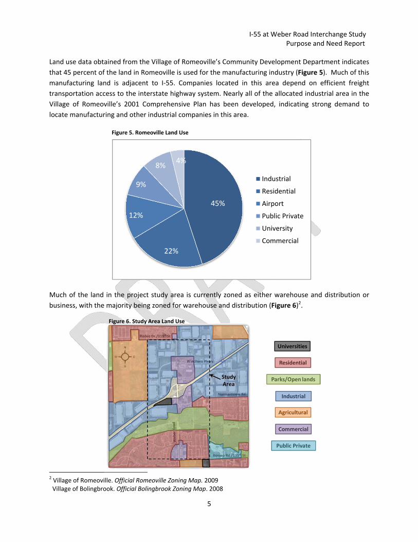
Land use data obtained from the Village of Romeoville’s Community Development Department indicates
that 45 percent of the land in Romeoville is used for the manufacturing industry (Figure 5). Much of this
manufacturing land is adjacent to I‐55. Companies located in this area depend on efficient freight
transportation access to the interstate highway system. Nearly all of the allocated industrial area in the
Village of Romeoville’s 2001 Comprehensive Plan has been developed, indicating strong demand to
locate manufacturing and other industrial companies in this area.
Much of the land in the project study area is currently zoned as either warehouse and distribution or
business, with the majority being zoned for warehouse and distribution (Figure 6)2.
2 Village of Romeoville. Official Romeoville Zoning Map. 2009 Village of Bolingbrook. Official Bolingbrook Zoning Map. 2008
Figure 6. Study Area Land Use
45%
22%
12%
9%
8%4%
Industrial
Residential
Airport
Public Private
University
Commercial
Figure 5. Romeoville Land Use

I‐55 at Weber Road Interchange Study Purpose and Need Report
6
Bolingbrook and Romeoville employment trends in freight transportation‐dependent industrial sectors
of manufacturing, wholesale trade, transportation, warehousing, and utilities show that these industrial
sectors account for approximately 24 to 28 percent of all jobs in each community (Table 2).
Table 2. Freight‐Dependent Industrial Sectors
Source: US Census Bureau, 2008
The manufacturing base depends on efficient and reliable freight transportation access between its
companies and the regional transportation system for materials and goods transportation. Weber Road
is an important link in manufacturing companies’ freight routes. Weber Road is located in the middle of
Bolingbrook’s largest industrial development area, and provides access to I‐55 for both Bolingbrook’s
and Romeoville’s industrial areas. The expanding manufacturing sector contributes to Weber Road
traffic delays and increased truck traffic.
Recognizing the growing transportation problems around the interchange, Will County completed a
Feasibility Study in 2009 to evaluate improvements to Weber Road and potential interchange
modifications.
2000 2008 Percent Change
Jobs
Percent oftotal Jobs
Jobs Percent of total Jobs
From 2000to 2008
Bolingbrook
Manufacturing 4,419 4,864 10.1%
Wholesale Trade 1,257 2,063 64.1%
Transportation, Warehousing, and Utilities 2,251 2,166 ‐3.8%
Total 7,927 27.1% 9,093 23.8%
Romeoville
Manufacturing 2,003 2,450 22.3%
Wholesale Trade 538 1,031 91.6%
Transportation, Warehousing, and Utilities 1,035 1,994 92.7%
Total 3,576 31.4% 5,475 27.7%
I‐55 at Weber Road Interchange Study Purpose and Need Report
7
1.4 Public Input IDOT identified the I‐55 at Weber Road Interchange Study as a Context Sensitive Solutions (CSS) project,
a process that requires early coordination with stakeholders to better understand the concerns and
needs of the communities in the project study area. As a part of the ongoing stakeholder involvement
throughout the study, the public’s input has been sought in the development of the project’s purpose.
Using CSS guidelines, a Community Advisory Group (CAG) was formed from a diverse group of residents,
local businesses, local and regional agency staff, and elected officials who volunteered at the project’s
first public meeting. The project study team met with the CAG to discuss the transportation problems,
community issues, and the community context associated with the I‐55 at Weber Road interchange.
Input from the CAG was used to develop the project’s problem statement; a written description of the
transportation issues associated with the interchange from a stakeholder’s perspective. The CAG
reached an agreement on three elements for the I‐55 at Weber Road problem statement:
Operations: I‐55 ramps, Weber Road mainline, and Weber Road intersections experience delays
due to high‐volume turn movements, lane markings, merging issues, poor signage, and traffic
signal density and timing.
Capacity: The high volumes of truck traffic from warehouses and distribution centers, a lack of
alternative north‐south routes, and inadequate access to I‐55 contribute to traffic in the
interchange area.
Safety and Efficiency: Traffic in the interchange area contributes to delays, impacts efficient
access to local businesses, and contributes to crashes on I‐55 and along Weber Road.
Based on stakeholder input, an inventory of existing conditions, 2040 traffic projections, and safety data,
the following needs were identified for the proposed project: safety, operations, and capacity
deficiencies.

I‐55 at Weber Road Interchange Study Purpose and Need Report
8
1.5 Need for the Proposed Action
1.5.1 Improve Safety An analysis of IDOT crash data from 2004‐2008 has indicated the need for improved safety in the
project study area. As part of the Federal Highway Administration Highway Safety Improvement
Program, states are required to describe at least five percent (5%) of highway locations exhibiting the
most pressing safety needs each year. Specifically, the safety issues that should be addressed in the
study area include the 5 % locations identified in the study area, the high number of crashes on Weber
Road near the interchange, and the lack of Americans with Disabilities Act (ADA), pedestrian, and
bicycle accommodations. Identified safety needs are presented in Figure 7.
Figure 7. Study Area Safety Deficiencies

I‐55 at Weber Road Interchange Study Purpose and Need Report
9
Interstate 55 (I‐55) Safety
Two locations along I‐55 around the Weber Road interchange were identified in IDOT’s 2009 IL 5%
report (Figure 7). Three fatalities occurred in the project study area; all along I‐55. The fatalities
resulted from impaired drivers and were likely contributors to the sections of I‐55 around the Weber
Road interchange being identified in 2009 as 5% locations.
Weber Road Safety
1,260 of the 1,666 crashes reported along Weber Road occurred within ¼ mile of the I‐55 interchange,
between Lakeview Road and Normantown Road (Figure 7). The high crash rates corresponded to the
amount of traffic; the majority of crashes along Weber Road occurred during peak travel hours.
However, there was a high amount of crashes occurring midday, indicating high levels of traffic
throughout the day. A majority of the recorded crashes were rear end (67%) crashes, many of which
resulted in property damage (84%); this type of crash is consistent with areas which have high levels of
congestion.
ADA, Pedestrian, and Bicycle Safety
ADA, pedestrian, and bicycle access is limited around the interchange; Weber Road has roughly 0.9
miles of sidewalks throughout the project study area. There are two areas with sidewalks north of the
I‐55 at Weber Road interchange, both along the west side of Weber Road. One of the walkways
stretches from 119th Street/Rodeo Drive to 550’ south of Carlow Drive and the other from Remington
Road/Wyndham Parkway to Lakeview Drive. These sidewalks are not continuous along Weber Road
(Figure 7).
South of I‐55, sidewalks exist on both sides of Weber Road from Grand Avenue/Carillon Drive to
Romeo Road/ 135th Street. The leg of sidewalk on the west side of Weber Road terminates 450’ north
of Romeo Road/135th Street. Sidewalks in this area connects the Remington Luxury Apartments,
Carillon, and Marquette Estates communities with the retail businesses and restaurants along Weber
Road that represent much of the typical commercial industries in the southern portion of the project.
The intersection of Weber Road and Grand Avenue/Carillon Drive represents the only intersection in
the study area that has a sidewalk on both the east and west sides of Weber Road (SW and SE
corners). However, the signal at this intersection signal does not include crosswalk marking or a
pedestrian phasing for the crossing. Overall deficiencies include a lack of crosswalks and signalized
crossings across Weber Road in the project study area. In addition, there is no existing provision for
pedestrians or bicyclists on the Weber Road Bridge over I‐55; however, pedestrians have been
observed walking along the raised median to traverse the interstate bridge.
There are two multi‐use paths in the study area, the Normantown Greenway and Panatoni Trail. They
are separated by a 900‐foot stretch of Weber Road (Figure 7) just south of Normantown Road. The
Normantown Greenway extends from Weber Road 1.5 miles east along the south side of Normantown
Road to Lukancic Middle School and meets the northern boundary of the 2 mile‐long Com Ed trail.
The Panatoni Trail travels 1.3 miles west through Lily Cache Slough from Weber Road, and terminates
at Budler Road. It is currently not possible to access Panatoni Trail from Normantown Road without
I‐55 at Weber Road Interchange Study Purpose and Need Report
10
entering private property. Multi‐use path users that would like to connect between the Normantown
Greenway and the Panatoni trail must cross Weber Road without a signalized crossing or crosswalk.
1.5.2 Address Operational Deficiencies Intersection Density
When the interchange was originally designed and built, the northbound I‐55 interchange ramps
intersected Weber Road 600 feet north of Normantown Road (Figure 8). Ideally, when a new
intersection is introduced it is intended to provide adequate space between the new and adjacent
intersections to form two distinct intersections that do not impede traffic operations. Although the
distance between Normantown Road and the northbound I‐55 ramps meets minimum spacing
requirements for access control along a crossroad at a diamond interchange, the spacing is inadequate
for current traffic conditions. IDOT’s BDE manual recommends that intersections are typically spaced
at least 1320 feet or ¼ of a mile apart for Weber Road’s posted speed of 45 mph and the existing
traffic signal cycle lengths of 130 seconds. This recommendation allows for vehicles to adequately
progress through the roadway corridor. However, the inadequate intersection spacing throughout
the Weber Road corridor has introduced additional traffic signal delay that may discourage some users
from using Weber Road because they perceive other routes, like Veterans Parkway, IL Route 53 or IL
Route 59, to be quicker and easier to use.
Insufficient Accepting Throat Width
Figure 8 shows the turning movements of design vehicles for dual left turn lanes at the intersection of
Weber Road and the southbound off ramp. The southbound exit ramp for I‐55 has two 12‐foot left
turn‐lanes and one 12‐foot right turn‐lane and the width of the roadway on southbound Weber Road
is insufficient for the dual left turn‐lanes exiting from southbound I‐55. The existing accepting throat
width (space available to make the turn) is 29 feet, creating a narrow turning path for dual left turning
movements onto Weber Road. The accepting throat width for turning traffic is the most important
design element for double left‐turn lanes. Drivers are most comfortable with extra space between the
turning queues of traffic. A 35‐foot throat width is desirable for acceptance of two turning design
vehicles because of the characteristics of vehicles (rear wheels do not follow the front wheels) and the
relative difficulty of two abreast turns.
Thru‐Lane Blockage
Stemming from inadequate storage and high traffic volumes, the left turn lane entering I‐55 from
southbound Weber Road exceeds capacity during peak travel periods. As a result, vehicles lined up to
turn left from Weber Road back up into the left of two southbound through lanes between the bridge
over the Interstate and the southbound ramp intersection. Vehicles turning left from the I‐55 exit
ramp onto southbound Weber Road must avoid traffic congestion in the left through lane by weaving
into the right turn lane and the left‐turning traffic in the adjacent. Although the north intersection at
the I‐55 at Weber Road interchange is affected, thru‐lane blocking was observed throughout the study
area.
Project area operational deficiencies are presented in Figure 8 (next page).

I‐55 at Weber Road Interchange Study Purpose and Need Report
11
Figure 8. Project Area Operational Deficiencies

I‐55 at Weber Road Interchange Study Purpose and Need Report
12
1.5.3 Improve Capacity The demand from regional growth and industrial development has resulted in increased traffic delays
along Weber Road, creating longer travel times for the efficient transport of both people and goods.
Figure 9 shows the 2010 two‐way average daily traffic (ADT) volumes along I‐55 are 106,400 vehicles
per day (vpd) southwest of the Weber Road interchange and 136,400 vpd northeast of the
interchange. The Chicago Metropolitan Agency for Planning ) forecasts that traffic volumes will
increase along I‐55 by 20% to 128,000 vpd southwest of the Weber Road interchange and by 7% to
146,000 vpd northeast of the interchange by 2040. Without improvements to Weber Road or the I‐55
at Weber Road Interchange (no build), CMAP forecasts that traffic will also increase along Weber
Road. Due to the proximity and density of industry in the interchange area, the portion of heavy
vehicles ranges from approximately 2% to 18% of the total traffic.
Figure 9. Existing and Forecasted Two‐Way Average Daily Traffic

I‐55 at Weber Road Interchange Study Purpose and Need Report
13
Level of Service (LOS) is the measure by which the quality of flow of a highway, roadway, or
intersection operates under specific traffic conditions. LOS accounts for the operating speed, traffic
density (vehicles per mile per lane), and traffic flow rate (vehicles per hour per lane). As travel speeds
decrease and traffic density increases, traffic flow becomes increasingly unstable. LOS is graded from
A to F; the AASHTO Highway Capacity Manual describes the LOS levels as A‐Optimum free flow, B‐
Reasonable free flow, C‐Stable flow, D‐Approaching unstable flow, E‐Unstable flow, F‐Forced or
breakdown flow. IDOT design standards require a Level of Service of C for suburban SRA routes, while
LOS D is acceptable for some interchange elements (BDE 37‐2.04).
Figure 10 illustrates AM and PM peak hour Level of Service for intersections and roadway sections
along Weber Road under the existing (2010) conditions. Several intersections operate with less than
desired standards (LOS E) during peak hours. Low LOS occurs for the intersection of Weber Road and
Normantown Road in the AM peak hour and at the intersections of Weber Road and the Southbound
I‐55 ramps and Romeo Road/135th Street during the PM peak hour.
Figure 10. Weber Road Existing Level of Service (LOS)
I‐55 at Weber Road Interchange Study Purpose and Need Report
14
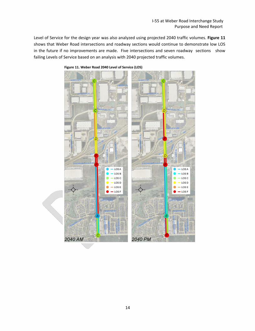
Level of Service for the design year was also analyzed using projected 2040 traffic volumes. Figure 11
shows that Weber Road intersections and roadway sections would continue to demonstrate low LOS
in the future if no improvements are made. Five intersections and seven roadway sections show
failing Levels of Service based on an analysis with 2040 projected traffic volumes.
Figure 11. Weber Road 2040 Level of Service (LOS)