1 weathering in the himalaya, an east- west comparison ... · 23 sections in the western (joginder...
TRANSCRIPT

1
Weathering in the Himalaya, an East- West comparison: Indications from major 1
elements and clay mineralogy 2
3
Natalie Vögeli*1, Peter van der Beek1, Pascale Huyghe1, Yani Najman2 4
5
1 Université Grenoble Alpes, Institut des Sciences de la Terre (ISTerre), Grenoble, France 6
2 Lancaster Environment Centre, Lancaster University, United Kingdom 7
*Corresponding author; ISTerre, Université Grenoble Alpes, 1381 Rue de la Piscine, 38058 8
Grenoble, Cedex 9, France ; [email protected] 9
10
11

2
Weathering in the Himalaya, an East- West comparison: Indications from major 12
elements and clay mineralogy 13
14
Abstract 15
Studying past weathering regimes is important for a better understanding of the influence 16
of climate on weathering, erosion and runoff. The Himalayan foreland basin contains a 17
record of tectonics and paleo-climate since Miocene times. Spanning the entire mountain 18
range, the Mio-Pliocene detrital Siwalik Group allows studies to directly compare the 19
western and eastern Himalaya within similar sedimentary settings. In this study, we use 20
major elements and clay mineralogy to reconstruct the weathering regime along strike 21
since Miocene times. We studied previously dated Dharamsala (pre-Siwalik) and Siwalik 22
sections in the western (Joginder Nagar, Jawalamukhi and Haripur Kolar sections) and 23
eastern (Kameng section) Himalaya in order to constrain variations in weathering regimes 24
along strike. The compilation of the three sections in the west makes for one of the longest 25
continuous sedimentary records in the Himalaya, spanning over 20 Ma. The K/Al ratio is 26
used as a reliable weathering proxy and shows a trend toward more intense weathering 27
over time in both the west and the east, but with sediments in the western Himalaya 28
generally more weathered than in the east, despite higher precipitation in the east. Clay 29
minerals and major elements indicate similar lateral variations in weathering. More intense 30
weathering in the west is linked to a more seasonal climate, permitting weathering of 31
sediments during the dry season, whereas higher runoff in the east leads to more rapid 32
erosion and sediment transport, inhibiting extensive weathering. 33

3
1. Introduction 34
The Himalayan mountain belt, together with the Tibetan plateau, exerts a strong influence 35
on regional climate, acting as an orographic barrier for the Asian monsoon (Boos and 36
Kuang, 2010). The monsoonal climate, in turn, has a major influence on erosion and relief 37
patterns (Bookhagen and Burbank, 2006; Clift et al., 2008; Thiede et al., 2004), which 38
influence chemical weathering intensity and fluxes (Galy and France-Lanord, 2001; West et 39
al., 2005). Chemical weathering plays a central role in global CO2 drawdown and climatic 40
cooling since the early Cenozoic (e.g., Kump et al., 2000). Thus, the Himalaya play a central 41
role in the globally coupled tectonic – climate – erosion system, and studies of past 42
weathering rates and regimes are crucial to unravel interactions between tectonics, 43
erosion, climate and weathering (e.g., Derry and France-Lanord, 1996). Moreover, spatial 44
variations in tectonics, erosion and weathering patterns can have implications for the past 45
climate and the evolution of the mountain belt. Lateral variations in erosion and 46
exhumation rates in the Himalaya have been investigated (e.g., Galy and France-Lanord, 47
2001; Thiede and Ehlers, 2013; van der Beek et al., 2016), but studies on spatial and 48
temporal variations of the weathering regime and intensities remain rare. 49
The modern monsoonal climate strongly impacts precipitation patterns in the Himalayan 50
region. Monsoonal winds take up moisture in the Arabian Sea and the Bay of Bengal and 51
transport it towards the Himalayan mountain front. This results in strong precipitation 52
during the northern-hemisphere summer months. The precipitation pattern varies along 53
strike, with generally more precipitation in the east than in the west (Bookhagen and 54
Burbank, 2010). During the winter months, precipitation is mostly focused on the western 55
and eastern terminations of the mountain belt, but the amount of precipitation remains 56

4
higher in the east than in the west (Bookhagen and Burbank, 2010). Himalayan river 57
discharge and sediment transport to the sea is linked to precipitation, and has an impact on 58
the storage of sediment in the floodplain (Andermann et al., 2012a; 2012b). Lupker et al. 59
(2012) showed that sediments in the floodplain are more weathered than sediments 60
collected from Himalayan rivers at the mountain front, pointing out the important role of 61
chemical weathering in the floodplain. 62
The Himalayan foreland-basin sediments, together with offshore sediments in the Indus 63
and Bengal fans, hold a record of tectonics, erosion, and climate since Miocene times. 64
Numerous studies have aimed at reconstructing paleo-vegetation and monsoon evolution 65
from this record (e.g., Clift et al., 2010; France-Lanord and Derry, 1994; Freeman and 66
Colarusso, 2001; Quade et al., 1989; Vögeli et al., in review). The most recent studies on the 67
onset of the monsoon date it back to the Eocene (Licht et al., 2014), even though the 68
evolution of the monsoon and its impact on precipitation patterns remains to be discussed. 69
A change in vegetation, from C3- to C4-plant dominated, has been documented at ~7 Ma, 70
which was interpreted as indicating drying of the climate as it became more seasonal 71
(Dettman et al., 2001). 72
Continental Himalayan foreland-basin sediments of the Siwalik group crop out along the 73
entire mountain front, allowing west-east comparisons within similar sedimentary settings, 74
while more scattered pre-Siwalik deposits allow pushing the record back to Early Miocene 75
times. Here we present paleo-weathering data of newly sampled Dharamsala (pre-Siwalik) 76
and Siwalik sections in north western India (Figure 1); the compilation of these sections 77
makes for the longest continuous sedimentary record in the Himalayan foreland basin. We 78
use clay mineralogy and whole-rock geochemistry to reconstruct the weathering intensity 79

5
and compare the Siwalik sections in the western Himalaya with the Kameng River section 80
in the eastern part of the Himalayan foreland basin Vögeli et al., accepted). Lateral 81
differences in δ13C of organic matter of bulk sediments from these same sections have been 82
interpreted as recording differences in the evolution of vegetation from west to east (Vögeli 83
et al., in review b). The current study is aimed at better understanding the relationship 84
between changes in vegetation, climate and weathering regime, by directly comparing the 85
evolution of the weathering regime in the west and the east, using the same proxies. 86
2. Geological setting 87
The evolution of the Himalaya is mainly driven by the early Cenozoic collision of the Indian 88
and Eurasian continents (X. Hu et al., 2016), which resulted in major crustal shortening and 89
thickening (Hodges, 2000; Yin and Harrison, 2000). A north-dipping fault system separates 90
the Himalaya into four major litho-tectonic units (Figure 1), which are, from north to south: 91
the Tethyan Sedimentary Series (TSS), the Higher Himalayan Crystalline Series (HHCS), the 92
Lesser Himalayan Series (LHS) and the Sub-Himalayas (SH). The main faults are, from 93
north to south: the South Tibetan Detachment System (STDS), which separates the TSS 94
from the HHCS; the Main Central Thrust (MCT), which lies between the HHCS and the LHS; 95
the Main Boundary Thrust (MBT), which separates the LHS and the SH; and the Main 96
Frontal Thrust (MFT), which thrusts the SH over the Ganga/Brahmaputra plain (DeCelles et 97
al., 2001; Le Fort, 1986; Yin and Harrison, 2000). The TSS is a Paleozoic-Eocene 98
sedimentary succession that was deposited on the Indian passive margin (Gaetani and 99
Garzanti, 1991). The HHCS comprises high-grade metamorphic rocks and granites, whereas 100
the LHS is composed of low-grade metasedimentary rocks (Hodges, 2000). The LHS has 101
been subdivided into the Inner Lesser Himalaya (iLH) and the Outer Lesser Himalaya 102

6
(oLH), based on different Nd-isotopic signatures (Ahmad et al., 2000): the iLH is 103
characterized by strongly negative εNd values, whereas the oLH has εNd values similar to the 104
HHCS and represents the low-grade metamorphic cover of the latter. The Sub-Himalaya, 105
the outermost unit, consists of the deformed Mio-Pliocene foreland-basin deposits of the 106
Siwalik Group, and crops out along the Himalaya from Pakistan all the way to northeastern 107
India (DeCelles et al., 1998; Ojha et al., 2009) (Figure 1). 108
Pre-Siwalik continental Cenozoic foreland-basin sedimentary rocks are found in the 109
western Himalaya; they are termed the Dharamsala Group and represent the Late 110
Oligocene/Early Miocene infill of the Himalayan foreland basin (Raiverman et al., 1983). 111
They consist of continental fluvial, lacustrine or deltaic sediments, and contain fine-to 112
medium grained sandstones, siltstones and overbank mudstones containing soil-carbonate 113
nodules (Najman et al., 2004). The Siwalik Group is divided into the Lower, Middle and 114
Upper Siwalik sub-groups, which are also known by local and laterally varying formation 115
names. The Lower Siwaliks (LS) consist of mudstones with some development of paleosols, 116
alternating with fine- to coarse-grained sandstones. The abundance of paleosols varies 117
laterally along strike and decreases towards the east. The LS were deposited by high-118
sinuosity streams (Nakayama and Ulak, 1999). The Middle Siwaliks (MS) are characterized 119
by massively bedded, medium- to coarse-grained micaceous sandstones. The MS represent 120
a depositional environment of large braided rivers. The Upper Siwaliks (US) consist of beds 121
of conglomerates alternating with sandstone beds, deposited by gravelly braided rivers. 122
Mudstones and paleosols are less frequent. Overall coarsening upward is observed in the 123
entire Siwalik Group, resulting from forward propagation of the Himalayan thrust front 124
7
(DeCelles et al., 1998; Dubille and Lavé, 2015), and boundaries between the sub-groups are 125
gradual. 126
The three sampled sections of this study in Himachal Pradesh, northwestern India, contain 127
Dharamsala (Joginder Nagar) and Siwalik (Joginder Nagar, Jawalamukhi and Haripur 128
Kolar) sedimentary rocks. They were previously dated by magnetostratigraphy (Meigs et 129
al., 1995; Sangode et al., 1996; White et al., 2001) and provide a composite age record that 130
ranges from 20 to 1 Ma (Figure 2). The Joginder Nagar (JN) section ranges from ~20 to 12 131
Ma and contains rocks of the Lower and Upper Dharamsala and Lower Siwalik subgroups, 132
with boundaries for the Lower/Upper Dharamsala at 16.5 Ma and Upper Dharamsala/LS at 133
12.5 Ma (White et al., 2001). In the Jawalamukhi section (JW), all three Siwalik sub-groups 134
(LS, MS and US) are present, with boundaries set at 10.9 Ma between LS and MS and at 6.8 135
Ma for the MS/US boundary (Meigs et al., 1995). The Haripur Kolar section (HK) contains 136
MS and US with the MS/US boundary at 5.23 Ma (Sangode et al., 1996). Soil-carbonate 137
nodules are present in Siwalik sediments in Pakistan (Quade et al., 1989), northwestern 138
India (Sanyal et al., 2010), and western and central Nepal (DeCelles et al., 1998; Quade et 139
al., 1995). They have never been reported more eastwards and are lacking in the Kameng 140
River section in Arunachal Pradesh, northeastern India (Vögeli et al., accepted). The setting 141
of the eastern Himalayan Siwalik section (Kameng section; KM) has been described 142
recently by Chirouze et al (2013) and Vögeli et al. (accepted). 143

8
3. Sampling and methods 144
3.1 Sampling strategy 145
In order to maximize the age constraints, we sampled according to the 146
magnetostratigraphic sampling points of White et al. (2001) for the JN section, Meigs et al. 147
(1995) for the JW section, and Sangode et al. (1996) for the HK section, using field notes 148
and maps of these previous publications. 2-3 samples per Ma were collected to obtain a 149
continuous age record. Samples were collected in pairs of adjacent fine- (mud/siltstone) 150
and coarse-grained (sandstone) sediment beds of the same age; fine-grained samples were 151
sampled in paleosols where present. Additionally, soil-carbonate nodules were collected 152
where present, which were analyzed for stable isotopes (Vögeli et al., in review b). Modern 153
river sand and mud was collected in proximity to the sections. 154
3.2 Methods 155
3.2.1 Clay mineralogy 156
The <2 µm fraction of clay minerals was extracted from selected samples from the JN, JW 157
and HK sections. To remove carbonate and organic matter, the samples were treated with 158
1M acetic acid and dissolved Na4P2O7, respectively. Samples were cleaned with MilliQ 159
water after each removal. The <2 µm fraction was separated by centrifuging the samples 160
(diluted in MilliQ) for 8 minutes at 700 rpm and pumping off the top 7 cm of the suspended 161
fraction. This procedure was repeated until a volume of 2 liters was reached (Moore and 162
Reynolds, 1997). Oriented aggregates were made on glass slides. X-ray diffractograms were 163
carried out on air-dried and ethylene-glycol-treated samples on a Bruker D8 Advance X-Ray 164
Diffractometer at ISTerre, Université Grenoble-Alpes. 165

9
Clay-mineral assemblages were obtained by a semi-quantitative peak analysis of the XRD 166
patterns. Based on their peak heights, clay minerals were added up to 100% (Capet et al., 167
1990), obtaining a percentage of different clay minerals with a relative error of ~5% 168
(Holtzappel, 1985). Illite crystallinity, also known as the Kübler Index (KI), was obtained by 169
measuring the full width at half maximum of the illite 10 Å peak on an X-ray diffractogram. 170
The KI determines three zones of very low-grade metamorphism: diagenesis, anchizone 171
and epizone (Kübler and Jaboyedoff, 2000). 172
Clay-mineral assemblages can be used as an indicator for weathering regimes (Setti et al., 173
2014). Smectite forms as a secondary clay mineral in soils and is enhanced in seasonal and 174
warm climates (Hillier, 1995; Huyghe et al., 2005; 2011), although formation of smectite is 175
also favored by weathering of volcanic rocks (Chamley, 1989). Kaolinite is preferentially 176
formed in warm and humid climates (Righi and Meunier, 1995; Setti et al., 2014). Smectite 177
and kaolinite should become more abundant with increasing weathering intensity. Illite 178
and chlorite represent detrital clays resulting from the physical erosion of the Himalayan 179
range, although illite can also be formed diagenetially; the KI (see above) allows 180
discriminating between detrital and diagenetic illite. Sediment provenance can potentially 181
influence clay mineralogy (Chamley, 1989; Garzanti et al., 2014) and should therefore be 182
taken into account when interpreting clay-mineral assemblages in terms of weathering. 183
3.2.2 Major elements 184
Samples were ground to a powder in an agate mortar, after which 50-70 mg of powder was 185
dissolved in a mixture of HF and HNO3 and heated for 72 h at 90 °C. The solution was 186
subsequently treated with boric acid to neutralize acids, and H2O2 to dissolve organic 187

10
matter. Major-element concentrations were analyzed on a Varian 720-ES inductively 188
coupled plasma atomic emission spectrometer (ICP-AES) at ISTerre, Université Grenoble 189
Alpes, using the method of Chauvel et al. (2011). International standard reference material 190
was analyzed parallel to the samples and was used to evaluate the accuracy at ~3 %, by 191
comparing measured and reference values. Loss on ignition (LOI) was obtained by weight 192
loss after heating at 1000 °C for an hour. Hydration (H2O+) of selected samples was 193
measured at the Service d'Analyse des Roches et des Minéraux (SARM), Centre de 194
Recherches Pétrographiques et Géochimiques (CRPG) in Nancy, France, with the Karl 195
Fischer titration method (cf. Lupker et al., 2012). 196
Ratios of mobile to immobile elements (K/Al, K/Si) and sediment hydration (H2O+) were 197
used as proxies for weathering intensity. However, ratios of K/Si and H2O+/Si are primarily 198
controlled by grain size and only secondarily by weathering (Lupker et al., 2012; 2013). 199
When plotting K/Si against Al/Si, coarse-grained sediments are represented in the lower 200
Al/Si range (< 0.15), and the steepness of the regression line is controlled by the degree of 201
weathering. Normalization of the mobile-to-immobile element ratios allows corrections for 202
differences in grain size of different samples. In order to obtain grain-size independent 203
proxies, ratios were normalized (K/Si* and H2O+/Si*) to a common Al/Si of 0.22 (the 204
average Al/Si of all measured coarse-grained samples in the west and east), with a 205
regression line through a coarse-grained end-member and the sample, following Lupker et 206
al. (2013). The K/Al ratio was also used as a more direct proxy for chemical weathering 207
intensity, as K/Al seems not to be primarily controlled by grain size (D. Hu et al., 2016). 208
11
4. Results 209
Here we report clay-mineral assemblages and major-element data for the Joginder Nagar, 210
Jawalamukhi and Haripur Kolar sections in northwest India. These are subsequently 211
compared to similar data from the eastern Himalaya (Kameng river section; Vögeli et al., 212
accepted). 213
4.1 Clay mineralogy 214
Clay minerals in the <2 µm fraction of clayey beds in the three western sections consist 215
mainly of illite, chlorite, smectite and kaolinite, the relative proportions of which vary with 216
time. In the JN and the lower part of the JW sections (Dharamsala and LS deposits dated 217
from 20 to ~10.5 Ma), clays are dominated by illite (illite+chlorite/∑clays > 0.6), which is 218
followed by an interval in which smectite and kaolinite are dominant 219
(illite+chlorite/∑clays < 0.5). Samples with depositional ages between ~8 and 5 Ma have 220
particularly high smectite content (> 50%). From 4 to 1 Ma, illite concentrations increase 221
again, but smectite remains more abundant than in the lower part of the section. The 222
modern Beas river sample is dominated by illite (65%; Figures 2, 3). 223
Illite crystallinity (KI) is fairly constant throughout the three sections (Figure 3). Values 224
vary from 0.12 to 0.23 Δ°2θ with illite crystallinity similar to muscovites from the Higher 225
Himalayan Crystalline Series (Huyghe et al., 2005). These values are representative for the 226
epizone of low-grade metamorphism, and indicate that illites are detrital rather than 227
diagenetic. 228

12
4.2 Major elements 229
Pairs of coarse- and fine-grained samples were analyzed; complete major-element results 230
are provided in Supplementary Table S1. Major-element compositions reflect the difference 231
in grain size, with coarse-grained samples containing more SiO2, whereas finer sediments 232
have higher K2O and Al2O3 concentrations. The ratio of the immobile elements Al2O3/SiO2 233
can be used as a grain-size proxy (Lupker et al., 2012). Plots of the concentrations of SiO2 vs 234
K2O and Al2O3 show a separation of fine- and coarse-grained sediments (Figure 4). Ratios of 235
mobile to immobile elements, such as K/Al, are used to quantitatively track weathering 236
intensity over time (Figure 5). K/Al ratios in the western sections are relatively constant at 237
~0.2 over the last 20 Ma, with an excursion to higher values of ~0.4 between ~7 and 5 Ma. 238
The concentration of calcium is very variable in the western sections, with an average of 239
3.7 wt % oxide (Figure 6). CaO does not correlate with SiO2, and therefore does not appear 240
to be dependent on grain size. 241
5. Discussion 242
Lateral variation in the climatic evolution of the Himalaya is reflected in a varying evolution 243
of vegetation, as inferred from the record of stable carbon isotopes, with C4 plants 244
becoming dominant in the western Himalaya, but not in the east, around 7 Ma. The 245
vegetation in the eastern part of the orogen is dominated by C3 plants since Miocene times 246
(Vögeli et al., in review b). The dominance of C4 plants since ~7 Ma in the western 247
Himalaya is interpreted as resulting from the change to an overall drier and more seasonal 248
climate at that time (Dettman et al., 2001; Quade and Cerling, 1995; Quade et al., 1989). In 249
contrast, climate in the east has remained too humid to develop C4 vegetation (Vögeli et al., 250

13
in review). By using complementary proxies to stable carbon isotopes, such as clay 251
minerals and major elements, the influences of this difference in climatic evolution on 252
weathering intensities and regimes are investigated here. Inferences on weathering 253
intensity and regime also depend, however, on the sensibility of the different proxies. In the 254
following, we first discuss potential provenance and diagenetic influences on weathering 255
signals in the western sections, and then compare the west and the east. 256
5.1 Provenance and diagenesis in the western sections 257
The provenance of sediments from the Joginder Nagar section has been determined using 258
whole-rock Sm-Nd isotopes, detrital white-mica Rb-Sr and Ar-Ar ages (White et al., 2002), 259
and detrital monazite U-Pb ages (White et al., 2001). Najman et al. (2009) used Ar-Ar ages 260
on detrital white micas, sandstone petrography and Sr-Nd isotopic compositions in the 261
Jawalamukhi section to reconstruct changes in provenance. The Lower Dharamsala (~20-262
17 Ma) sediments are mainly sourced from the HHCS (Figure 2). At the boundary from the 263
Lower to Upper Dharamsala, provenance changes from high-grade metamorphic rocks to 264
low-grade metamorphic and sedimentary rocks of the oLH (Haimanta series; White et al., 265
2002). iLH material is present in the Siwalik sediments from at least ~9 Ma. In the 266
Jawalamukhi section, HHCS material cuts out completely at 7 Ma (Najman et al., 2009) and 267
the iLH becomes the dominating source of the Siwalik sediments. From 6 Ma on, detritus 268
from Proterozoic granitoids is present. Isotopic provenance studies in the Haripur Kolar 269
section are lacking. Basic provenance analysis was based on clay minerals and petrography 270
and indicates an HHCS and LHS source (Suresh et al., 2004). Peak activity of the Main 271
Frontal Thrust has been established at 1.8 Ma, and is associated with recycling of Siwalik 272
sedimentary rocks in the uppermost Siwalik series (Kumar et al., 2003). Major changes in 273

14
provenance thus occurred at ~17 Ma (oLH coming in), at 9 Ma (iLH coming in), and at 7 Ma 274
(HHCS cuts out). 275
Illite crystallinity (Kübler Index) can be used to distinguish different low-grade 276
metamorphic zones. In the Karnali section in western Nepal, illite crystallinity starts to 277
increase from a stratigraphic depth of ~2100 m (Huyghe et al., 2005), indicating diagenetic 278
illite at these depths. Illitisation of smectite begins at a temperature of 70-95°C (Dunoyer 279
De Segonzac, 1970). It is thus important to approximately know to what temperatures the 280
rocks in our sections could have been heated during burial, in order to establish the 281
potential diagenetic influence on other proxies. Additionally to illite crystallinity, apatite 282
fission-track (AFT) ages can be used to constrain a burial temperature. Partially or fully 283
reset AFT ages are a clear indicator that sedimentary rocks were heated to 60-120°C, the 284
AFT partial annealing zone (Tagami and O'Sullivan, 2005). Estimated burial depths for total 285
AFT annealing are ~4000 m in the Kameng section (Chirouze et al., 2013) and ~3000 m in 286
central/western Nepal (Surai, Tinau, Karnali sections; van der Beek et al., 2006), 287
respectively. AFT analyses are lacking for the JN, JW and HK sections, but paleotemperature 288
estimates from vitrinite reflectance of the Dagshai (max. age 33 Ma) and Kasauli (max. age 289
22 Ma) formations, which are the along-strike equivalents of the Dharamsala Group further 290
east, are between ~160 and 200 °C (Najman et al., 2004). In contrast, in the western 291
sections (this study), illite crystallinity is relatively constant and lies in the epizone field, 292
suggesting that the illite is mostly detrital, similar to what is observed in the Kameng 293
section (Figure 3). Illite crystallinity therefore reflects source-area metamorphism. None of 294
the western samples fall into the diagenesis field, which should be the case if illitisation of 295
smectite had occurred (Huyghe et al., 2005; Lanson et al., 1995). There is no sign of 296

15
illitisation of smectite throughout the western sections, suggesting that the influence of 297
diagenesis is likely to be minor, or at least not affecting the clay minerals in the western 298
sections. 299
In these sections, clay mineralogy begins to change at ~11 Ma, when smectite becomes 300
more abundant and remains so until ~1 Ma. Clay mineralogy, therefore, does not appear 301
correlated with changes in provenance, as smectite becomes abundant at ~11 Ma and 302
remains stable after that, whereas provenance changes occur at ~9 Ma and especially at 7 303
Ma. Since neither diagenesis nor provenance are likely to bias the clay-mineralogy signal, 304
variations in clay mineralogy can be mostly ascribed to changes in weathering intensity 305
and regime through time. 306
K/Al ratios do not show a correlation with burial depth; diagenesis is therefore likely to be 307
of negligible influence on K/Al ratios. K/Al ratios in the west remain relatively constant 308
over time, except between ~7 and 5 Ma, where K/Al values are anomalously high. Several 309
samples between 7 and 5 Ma have K/Al ratios of ~0.4 (Figure 5), indicating the presence of 310
“fresh”, nearly unweathered material. These samples were collected in the upper part of 311
the Jawalamukhi section (MS), where conglomerate is frequent (Figure 2). They are 312
depleted in Al because of the grain-size effect. Moreover, conglomerates represent a 313
proximal depositional environment close to the mountain front, where sediments are less 314
weathered compared to those in the floodplain (Lupker et al., 2012). The US of the Haripur 315
Kolar section do not show high K/Al values, high values are only present in sedimentary 316
rocks of the Jawalamukhi section. Provenance changes between 7 and 6 Ma, when material 317
sourced from Proterozoic granitoids are brought in and HHCS is cut out, could potentially 318
influence K/Al ratios because these granitoid sources are expected to have elevated K-319

16
concentration. However, the K-concentration in these samples does not show exceptionally 320
high values (Table S1). The increase in K/Al between ~7 and 5 Ma is therefore more likely 321
to be related to the depositional environment becoming locally more proximal and an 322
additional change in provenance, than to a change of climate. 323
5.2 West-east comparison of weathering regimes 324
The three pre-Siwalik and Siwalik sections in the western Himalaya form the longest 325
composite continuous sedimentary record in the Himalayan foreland basin, which allows 326
us to reconstruct weathering history since the Early Miocene. Weathering intensity in the 327
western Himalaya is fairly constant from ~21 to ~13 Ma, after which it slightly decreases 328
until 7 Ma, as inferred from K/Al and K/Si* ratios (Figure 5). The period between 7 and 5 329
Ma is characterized by exceptionally low weathering, reflected in a high K/Al ratio. From 5 330
to 1 Ma, weathering is relatively constant at a K/Al value of ~0.20, similar to the period 331
from 21 to 13 Ma, with some variation around 3 Ma (Figure 5). 332
In the eastern Kameng section, K/Al ratios indicate an increase in weathering intensity 333
with time, the Upper Siwaliks being more weathered than the Lower Siwaliks. As the 334
Kameng River section only spans the last 13 Ma, a direct comparison can only be made for 335
the mid-Miocene to Pleistocene. Sediments of the Dharamsala Group in the west (older 336
than 13 Ma, and absent in the east), are generally more weathered than the Lower Siwaliks 337
in the east. In general, sediments from the east show a higher K/Al ratio, hence are less 338
weathered, than sediments from the western sections. The period between ~7 and 5 Ma is 339
exceptional, with sediment in the west being less weathered, showing anomalous values of 340
K/Al up to 0.4. However, as discussed above, we suggest this to be a signal related to the 341

17
source and the specific depositional environment, rather than regional weathering 342
intensity. 343
A potential factor controlling variations in weathering intensity could be recycling of 344
Siwalik or older sediments. The Siwaliks show striking differences in width and internal 345
deformation from east to west, with western sections generally being wider and showing 346
more internal thrusts (e.g., Hirschmiller et al., 2014). If such internal deformation led to 347
recycling of Siwalik sediments, this might explain the stronger weathering intensity 348
recorded in the western sections. However, petrographic data from the Joginder Nagar and 349
Jawalamukhi sections do not indicate significant recycling (White et al., 2002; Najman et al., 350
2009), while in the eastern Kameng section some outlier datapoints were interpreted as 351
indicating limited recycling (Vögeli et al., accepted). In general, significant recycling should 352
lead to increasing weathering intensity upsection, which is observed in the Kameng but not 353
in the western sections. Therefore, we do not think that sediment recycling can explain the 354
differences between the western and eastern sections. 355
By plotting K/Si against Al/Si (Figure 7), a weathering signal can be extracted from the 356
steepness of regression lines (Lupker et al., 2013). We calculated the 95% confidence 357
interval for each linear regression, to show the uncertainty of the regression line. 358
Confidence levels of regression do not show a clear separation, although eastern sediments 359
seem to be slightly more weathered, which contradicts the inference from the K/Al data 360
and may be due to the period of very low weathering in the west between 7 and 5 Ma 361
(Figure 7, orange circle). By taking out the anomalously unweathered samples between 7 362
and 5 Ma, we would expect the regression line of the western sections to change its 363
steepness, but it remains steeper than that of the eastern sediments (i.e., indicating less 364
18
intense weathering). Plotting K/Si versus Al/Si shows the primary control of grain size. 365
Coarse-grained sediments of the western sections are more weathered than coarse-grained 366
sediments in the Kameng; this slight difference influences the steepness of the regression 367
line. In order to directly compare weathering in the west and east, plotting K/Al versus age 368
thus appears more suitable (Figure 5), as absolute K/Al values can be directly compared 369
within different sections. K/Al appears to be a robust proxy for reconstructing weathering 370
intensities, as also confirmed by a recent study in the South China Sea (D. Hu et al., 2016). 371
Other weathering proxies, such as the Chemical Index of Alteration (CIA) (Nesbitt and 372
Young, 1984) are more difficult to use, due to the variation in carbonate content of the 373
sediments and changes in provenance. Calcium concentrations vary laterally, with higher 374
Ca concentration in the west (average of 3.7 wt % oxide compared to 0.7 wt % oxide in the 375
east) resulting in the abundance of soil-carbonate nodules in the western sections (Figure 376
6). In contrast, soil-carbonate nodules are absent in the Kameng section; they have never 377
been reported more eastwards than eastern Nepal. As the climate is and probably has been 378
more humid in the past in the east than in the west (Bookhagen and Burbank, 2006; Vögeli 379
et al., in review), it is likely that calcium was dissolved and the formation of soil-carbonate 380
nodules was inhibited in the eastern sections. 381
δ13Corg shows important variations from west to east along the Himalayan front at ~7/8 Ma 382
(Vögeli et al., in review), which are not reflected in the clay mineralogy. Clay mineralogy 383
within the different Siwalik sections is quite similar, with clay-mineral assemblages 384
starting to be more smectite rich somewhere between 11 and 7 Ma (the exact timing 385
varying laterally), and being characterized by a high illite content in the stratigraphically 386
lower series (Dharamsala and LS). This pattern is also observed in the distal Bengal-Fan 387

19
record (France-Lanord et al., 1993). In the Kameng River section, the smectite-rich period 388
occurs from 8 Ma until 3 Ma, when kaolinite becomes more abundant. On the other hand, 389
smectite starts to be more abundant at ~11 Ma in the west and stays the dominant clay 390
mineral up to 1 Ma. In the east, the smectite-rich period also coincides with a change in 391
source (Chirouze et al., 2013; Vögeli et al., accepted). However, although sources in the 392
west and the east are different, types of smectite seem to be similar, as indicated by similar 393
XRD peaks (Appendix 2). We therefore suggest that the abundance of smectite is likely to 394
be controlled by climate rather than by provenance. Kaolinite is less abundant in the west 395
than in the east. The modern clay-mineral assemblages of the Beas River (sampled in 396
proximity of the section) in the west is dominated by illite, similar to other Himalayan 397
rivers (Kameng and Subansiri rivers) and the Brahmaputra in the east (Vögeli et al., 398
accepted). In contrast, the Ganges (further into the floodplain) carries more smectite 399
(Huyghe et al., 2011). Smectites can be formed under enhanced weathering and seasonal 400
conditions, as is the case in the Ganges floodplain today. The increasing abundance of 401
smectite since 7-11 Ma can, therefore, be interpreted to reflect a change towards a more 402
seasonal climate (Huyghe et al., 2005). The dominance of smectite in the western sections 403
between 8 and 5 Ma could thus be an indicator of a more seasonal climate, which is 404
supported by the appearance of C4 plants during this time (Quade and Cerling, 1995; 405
Vögeli et al., in review); C4 plants are known to be more resistant to water stress, hence 406
seasonal climate (Ehleringer, 1988). Clay-mineral assemblages and stable carbon isotopes, 407
hence vegetation, thus both reflect mostly seasonality of the climate. Clay mineralogy also 408
suggests increasing weathering intensity with the abundance of smectite at ~8 Ma. K/Al 409
and K/Si ratios, in contrast, suggest less weathering in the period between ~7 to 5 Ma in 410

20
the west (Figures 5 and 7). In the Kameng section, an overall increase in weathering 411
intensity is observed, with a major change towards more intense weathering at 8 Ma 412
(Figure 5; Vögeli et al., accepted). 413
Generally, K/Al ratios show that sediments deposited in the east (Kameng section) were 414
less weathered than in the west since the mid-Miocene. In contrast, modern precipitation is 415
higher and less seasonal in the eastern Himalaya, driving more intense runoff and erosion 416
(Bookhagen and Burbank, 2010; Galy and France-Lanord, 2001). The contrasting stable 417
carbon-isotope patterns between the west and the east show that this lateral climatic 418
contrast has been in place since ~7 Ma (Vögeli et al., in review). Lupker et al. (2012) 419
showed that sediments are predominantly weathered in the floodplain; rapid transport 420
through the floodplain therefore inhibits extensive weathering. The apparent contradiction 421
between a more humid climate and less intense weathering in the east can be resolved by 422
hypothesizing that sediment storage in the floodplain was less important, due to higher 423
runoff and more efficient sediment transport. A similar contrast can be observed when 424
comparing the marine records of the Indus and the Bengal Fans (Clift et al., 2008). 425
The Indian Summer Monsoon is the main driver for the precipitation pattern along the 426
Himalayan front. The most recent studies on the onset of the Indian Summer Monsoon 427
suggest that it was active in Eocene times (Licht et al., 2014). We can therefore assume that 428
monsoonal winds transported moisture from the Bay of Bengal to the Himalaya since this 429
time, although the variation in monsoon strength over time remains to be evaluated. 430
Marine records of the Bengal and the Indus fans have been used to reconstruct 431
paleoclimate in the Himalayan region (Clift and Gaedicke, 2002; Clift et al., 2008; France-432
Lanord et al., 1993, amongst others). Figure 8 shows K/Si vs Al/Si ratios for sedimentary 433

21
rocks of the western and eastern Siwaliks together with modern sediments of the Ganges 434
River (Lupker et al., 2013), and sediments from the Indus fan (~16-1 Ma; Clift et al., 2008). 435
The overall westward increase in weathering intensity that we infer from our Siwalik 436
sections is confirmed by including these additional data, as Indus-fan sediments appear to 437
be slightly more weathered than both the proximal Siwalik record and the modern 438
sediments of the Ganges River. Thus, sediments in the drier, more seasonal western 439
Himalaya seem to be generally more weathered than in the more humid but less seasonal 440
eastern part of the belt, and have been so since the Miocene. 441
6. Conclusions 442
The Himalayan foreland basin is an excellent laboratory to study lateral variations in the 443
evolution of climate and weathering regimes, as foreland-basin sediments of the Siwalik 444
Group crop out along the entire mountain front and contain a continuous record of 445
tectonics, erosion, climate and weathering. The compilation of three sections (JN, JW, HK) 446
in the western Himalaya allows reconstruction of climate and weathering as far back as the 447
Early Miocene. The lack of longer records in the east limits direct comparison between the 448
western and eastern Himalayan foreland to mid-Miocene and later times. By studying clay 449
mineralogy and major-element compositions, taking potential provenance and diagenetic 450
biases into account, important insights into past weathering and climatic regimes can be 451
gained. The K/Al ratio in particular appears to be a robust proxy for past weathering 452
intensities. 453
The smectite content of Himalayan foreland-basin sediments increases from 11 Ma in the 454
west and 8 Ma in the east, respectively. Illite crystallinity does not increase down-section, 455

22
suggesting that illitisation of smectite did not occur in the studied sections. The influence of 456
diagenesis can therefore be considered negligible and the change in clay mineralogy can be 457
ascribed to a change towards a more seasonal climate. The relative abundance of kaolinite 458
over smectite in the east is consistent with a more humid but less seasonal climate. K/Al is 459
also generally higher in the east, indicating less intense weathering. Less intense 460
weathering in the eastern Himalaya is interpreted as resulting from a more humid but less 461
seasonal climate, leading to more erosion and runoff. The resulting shorter residence time 462
of sediments in the floodplain can explain the observed less intense weathering. In both the 463
west and the east, a slight trend towards more intense weathering with time can be 464
observed, which we interpret as being due to a climatic evolution toward more seasonality. 465
Throughout the studied time span, seasonality appears to be stronger in the west of the 466
mountain belt than in the east, as it is today. During the period between ~7 and 5 Ma, 467
sediments in the west are particularly unweathered; however, we link this excursion to a 468
change in provenance and depositional environment, rather than a major change in 469
climate. 470
Reconstruction of past climate and weathering regimes remains a challenging task. The 471
monsoonal climate and its evolution is still not fully understood. In particular, the 472
monsoonal influence on seasonality linked with overall humidity needs to be further 473
investigated. Paleo-vegetation, clay mineralogy and major elements can be used as 474
indicators for seasonality, but more such paleo-seasonality studies are crucial to 475
understand the evolution of the monsoon., 476

23
Acknowledgements 477
We thank Gwladys Govin and Lorenzo Gemignani for field assistance, and Nathaniel 478
Findling and Sarah Bureau for help in preparing the samples. We acknowledge financial 479
support from a Marie Curie Initial Training Network iTECC funded by the EU REA under the 480
FP7 implementation of the Marie Curie Action, under grant agreement # 316966. 481
Comments by Peter Clift and an anonymous reviewer helped to improve the manuscript. 482
483

24
References cited 484
Ahmad, T., Harris, N., Bickle, M., Chapman, H., Bunbury, J., and Prince, C., 2000, Isotopic 485
constraints on the structural relationships between the Lesser Himalayan Series and 486
the High Himalayan Crystalline Series, Garhwal Himalaya: GSA Bulletin, v. 112, no. 3, 487
p. 467-477. 488
Andermann, C., Bonnet, S., Crave, A., Davy, P., Longuevergne, L., and Gloaguen, R., 2012a, 489
Sediment transfer and the hydrological cycle of Himalayan rivers in Nepal: Comptes 490
Rendus Geoscience, v. 344, no. 11–12, p. 627-635. 491
Andermann, C., Crave, A., Gloaguen, R., Davy, P., and Bonnet, S., 2012b, Connecting source 492
and transport: Suspended sediments in the Nepal Himalayas: Earth and Planetary 493
Science Letters, v. 351–352, p. 158-170. 494
Bookhagen, B., and Burbank, D. W., 2006, Topography, relief, and TRMM-derived rainfall 495
variations along the Himalaya: Geophysical Research Letters, v. 33, no. 8, p. L08405. 496
Bookhagen, B., and Burbank, D. W., 2010, Toward a complete Himalayan hydrological 497
budget: Spatiotemporal distribution of snowmelt and rainfall and their impact on 498
river discharge: Journal of Geophysical Research: Earth Surface, v. 115, no. F03019. 499
Boos, W. R., and Kuang, Z., 2010, Dominant control of the South Asian monsoon by 500
orographic insulation versus plateau heating: Nature, v. 463, no. 7278, p. 218-222. 501
Capet, X., Chamley, H., Beck, C., and Holtzappel, T., 1990, Clay mineralogy of ODP sites 671 502
and 672, Barbados Ridge Accretionary Complex and Atlantic Abyssal Plain: 503
palaeoenvironmental and diagenetic implications.: In: Proceedings of the Ocean 504
Drilling Program, Scientifc Results, Vol. 110 (Ed. by A.Mascle, J.C. Moore & E. Taulor, 505
et al.). Ocean Drilling Program, College Station,TX., p. 85-96. 506

25
Chamley, H., 1989, Clay Sedimentology: Springer Verlag, Berlin, 623 pp. 507
Chauvel, C., Bureau, S., and Poggi, C., 2011, Comprehensive chemical and isotopic analyses 508
of basalt and sediment reference materials: Geostandards and Geoanalytical 509
Research, v. 35, no. 1, p. 125-143. 510
Chirouze, F., Huyghe, P., van der Beek, P., Chauvel, C., Chakraborty, T., Dupont-Nivet, G., and 511
Bernet, M., 2013, Tectonics, exhumation, and drainage evolution of the eastern 512
Himalaya since 13 Ma from detrital geochemistry and thermochronology, Kameng 513
River Section, Arunachal Pradesh: Geological Society of America Bulletin, v. 125, no. 514
3-4, p. 523-538. 515
Clift, P., and Gaedicke, C., 2002, Accelerated mass flux to the Arabian Sea during the middle 516
to late Miocene: Geology, v. 30, no. 3, p. 207-210. 517
Clift, P. D., Hodges, K. V., Heslop, D., Hannigan, R., Van Long, H., and Calves, G., 2008, 518
Correlation of Himalayan exhumation rates and Asian monsoon intensity: Nature 519
Geoscience, v. 1, no. 12, p. 875-880. 520
Clift, P. D., Tada, R., and Zheng, H., 2010, Monsoon evolution and tectonics-climate linkage 521
in Asia: an introduction: Geological Society, London, Special Publications, v. 342, no. 522
1, p. 1-4. 523
DeCelles, P. G., Gehrels, G. E., Quade, J., Ojha, T. P., Kapp, P. A., and Upreti, B. N., 1998, 524
Neogene foreland basin deposits, erosional unroofing, and the kinematic history of 525
the Himalayan fold-thrust belt, western Nepal: Geological Society of America 526
Bulletin, v. 110, no. 1, p. 2-21. 527

26
DeCelles, P. G., Robinson, D. M., Quade, J., Ojha, T. P., Garzione, C. N., Copeland, P., and Upreti, 528
B. N., 2001, Stratigraphy, structure, and tectonic evolution of the Himalayan fold-529
thrust belt in western Nepal: Tectonics, v. 20, no. 4, p. 487-509. 530
Derry, L. A., and France-Lanord, C., 1996, Neogene Himalayan weathering history and river 531
87Sr/86Sr: impact on the marine Sr record: Earth and Planetary Science Letters, v. 532
142, no. 1–2, p. 59-74. 533
Dettman, D. L., Kohn, M. J., Quade, J., Ryerson, F. J., Ojha, T. P., and Hamidullah, S., 2001, 534
Seasonal stable isotope evidence for a strong Asian monsoon throughout the past 535
10.7 m.y: Geology, v. 29, no. 1, p. 31-34. 536
Dubille, M., and Lavé, J., 2015, Rapid grain size coarsening at sandstone/conglomerate 537
transition: similar expression in Himalayan modern rivers and Pliocene molasse 538
deposits: Basin Research, v. 27, no. 1, p. 26–42. 539
Dunoyer De Segonzac, G., 1970, The transformation of clay minerals during diagenesis and 540
low-grade metamorphism: A review.: Sedimentology, v. 15, no. 3-4, p. 281-346. 541
Ehleringer, J. R., 1988, Carbon isotope ratios and physiological processes in aridland plants. 542
In Ehleringer, J.R., Nagy, K.A. (Eds.), Stable Isotope in Ecological Research.: Springer, 543
New York, p. 41-54. 544
France-Lanord, C., Derry, L., and Michard, A., 1993, Evolution of the Himalaya since Miocene 545
time: isotopic and sedimentological evidence from the Bengal Fan: Geological 546
Society, London, Special Publications, v. 74, no. 1, p. 603-621. 547
France-Lanord, C., and Derry, L. A., 1994, δ13C of organic carbon in the Bengal Fan: Source 548
evolution and transport of C3 and C4 plant carbon to marine sediments: Geochimica 549
et Cosmochimica Acta, v. 58, no. 21, p. 4809-4814. 550

27
Freeman, K. H., and Colarusso, L. A., 2001, Molecular and isotopic records of C4 grassland 551
expansion in the late Miocene: Geochimica et Cosmochimica Acta, v. 65, no. 9, p. 552
1439-1454. 553
Gaetani, M., and Garzanti, E., 1991, Multicyclic history of the northern India continental 554
margin (northwestern Himalaya): American Association of Petroleum Geologists 555
Bulletin, v. 75, p. 1427-1446. 556
Galy, A., and France-Lanord, C., 2001, Higher erosion rates in the Himalaya: Geochemical 557
constraints on riverine fluxes: Geology, v. 29, no. 1, p. 23–26. 558
Garzanti, E., Padoan, M., Setti, M., López-Galindo, A., and Villa, I. M., 2014, Provenance 559
versus weathering control on the composition of tropical river mud (southern 560
Africa): Chemical Geology, v. 366, p. 61-74. 561
Hillier, S., 1995, Erosion, Sedimentation and Sedimentary Origin of Clays, in Velde, B., ed., 562
Origin and Mineralogy of Clays: Clays and the Environment: Berlin, Heidelberg, 563
Springer Berlin Heidelberg, p. 162-219. 564
Hirschmiller, J., Grujic, D., Bookhagen, B., Coutand, I., Huyghe, P., Mugnier, J.L., and Ojha, T., 565
2014, What controls the growth of the Himalayan foreland fold-and-thrust belt?: 566
Geology, v. 42, no. 3, p. 247–250. 567
Hodges, K. V., 2000, Tectonics of the Himalaya and southern Tibet from two perspectives: 568
Geological Society of America Bulletin, v. 112, no. 3, p. 324-350. 569
Holtzappel, T., 1985, Les minéraux argileux, préparation, analyse diffractométrique et 570
détermination.: Soc. Géol.Nord., v. 12, p. 1-36. 571

28
Hu, D., Clift, P. D., Wan, S., Böning, P., Hannigan R., Hillier S. and Blusztajn J., 2016, Testing 572
chemical weathering proxies in Miocene-Recent fluvial-derived sediments in the 573
South China Sea: Geological Society, London, Special Publications, v. 429, p. 45-72. 574
Hu, X., Wang, J., BouDagher-Fadel, M., Garzanti, E., and An, W., 2016, New insights into the 575
timing of the India–Asia collision from the Paleogene Quxia and Jialazi formations of 576
the Xigaze forearc basin, South Tibet: Gondwana Research, v. 32, p. 76-92. 577
Huyghe, P., Guilbaud, R., Bernet, M., Galy, A., and Gajurel, A. P., 2011, Significance of the clay 578
mineral distribution in fluvial sediments of the Neogene to Recent Himalayan 579
Foreland Basin (west-central Nepal): Basin Research, v. 23, no. 3, p. 332-345. 580
Huyghe, P., Mugnier, J.-L., Gajurel, A. P., and Delcaillau, B., 2005, Tectonic and climatic 581
control of the changes in sedimentary record of the Karnali River section (Siwaliks 582
of western Nepal). The Island Arc, v. 14, p. 311-327. 583
Kübler, B., and Jaboyedoff, M., 2000, Illite crystallinity: Comptes Rendus de l'Académie des 584
Sciences - Series IIA - Earth and Planetary Science, v. 331, no. 2, p. 75-89. 585
Kumar, R., Ghosh, S. K., Mazari, R. K., and Sangode, S. J., 2003, Tectonic impact on the fluvial 586
deposits of Plio-Pleistocene Himalayan foreland basin, India: Sedimentary Geology, 587
v. 158, no. 3–4, p. 209-234. 588
Kump, L.R., Brantley, S.L., and Arthur, M.A., 2000, Chemical weathering, atmospheric CO2, 589
and climate: Annual Review of Earth and Planetary Sciences, v. 28, p. 611–667. 590
Lanson, B., Beaufort, D., Berger, G., Petit, S., and Lacharpagne, J. C., 1995, Evolution de la 591
structure cristallographique des minéraux argileux dans le réservoir gréseux 592
Rotliegend des Pays-Bas: Bulletin des Centres de Recherche Elf Aquitaine 593
Production, v. 19, p. 243-265. 594

29
Le Fort, P., 1986, Metamorphism and magmatism during the Himalayan collision: 595
Geological Society, London, Special Publications, v. 19, no. 1, p. 159-172. 596
Licht, A., van Cappelle, M., Abels, H. A., Ladant, J. B., Trabucho-Alexandre, J., France-Lanord, 597
C., Donnadieu, Y., Vandenberghe, J., Rigaudier, T., Lecuyer, C., Terry Jr, D., Adriaens, 598
R., Boura, A., Guo, Z., Soe, A. N., Quade, J., Dupont-Nivet, G., and Jaeger, J. J., 2014, 599
Asian monsoons in a late Eocene greenhouse world: Nature, v. 513, no. 7519, p. 501-600
506. 601
Lupker, M., France-Lanord, C., Galy, V., Lavé, J., Gaillardet, J., Gajurel, A. P., Guilmette, C., 602
Rahman, M., Singh, S. K., and Sinha, R., 2012, Predominant floodplain over mountain 603
weathering of Himalayan sediments (Ganga basin): Geochimica et Cosmochimica 604
Acta, v. 84, p. 410-432. 605
Lupker, M., France-Lanord, C., Galy, V., Lavé, J., and Kudrass, H., 2013, Increasing chemical 606
weathering in the Himalayan system since the Last Glacial Maximum: Earth and 607
Planetary Science Letters, v. 365, p. 243-252. 608
Meigs, A. J., Burbank, D. W., and Beck, R. A., 1995, Middle-late Miocene (>10 Ma) formation 609
of the Main Boundary thrust in the western Himalaya: Geology, v. 23, no. 5, p. 423-610
426. 611
Moore, D. M., and Reynolds, R. C., 1997, X-Ray diffraction and the identification and analysis 612
of clay minerals, 2nd Ed.: Oxford University Press, New York, 400 pp. 613
Najman, Y., Bickle, M., Garzanti, E., Pringle, M., Barfod, D., Brozovic, N., Burbank, D., and 614
Ando, S., 2009, Reconstructing the exhumation history of the Lesser Himalaya, NW 615
India, from a multitechnique provenance study of the foreland basin Siwalik Group: 616
Tectonics, v. 28, no. 5, p. TC5018. 617
30
Najman, Y., Johnson, K., White, N., and Oliver, G., 2004, Evolution of the Himalayan foreland 618
basin, NW India: Basin Research, v. 16, no. 1, p. 1-24. 619
Nakayama K. & Ulak P. D. 1999, Evolution of fluvial style in the Siwalik Group in the 620
foothills of the Nepal Himalaya. Sedimentary Geology 125, 205–24. 621
Nesbitt, H. W., and Young, G. M., 1984, Prediction of some weathering trends of plutonic and 622
volcanic rocks based on thermodynamic and kinetic considerations: Geochimica et 623
Cosmochimica Acta, v. 48, no. 7, p. 1523-1534. 624
Ojha, T. P., Butler, R. F., DeCelles, P. G., and Quade, J., 2009, Magnetic polarity stratigraphy of 625
the Neogene foreland basin deposits of Nepal: Basin Research, v. 21, no. 1, p. 61-90. 626
Quade, J., Cater, J. M. L., Ojha, T., Adam, J., and Harrison, T. M., 1995, Late Miocene 627
environmental change in Nepal and the northern Indian subcontinent: Stable 628
isotopic evidence from paleosols: Geological Society of America Bulletin, v. 107, no. 629
12, p. 1381-1397. 630
Quade, J., and Cerling, T. E., 1995, Expansion of C4 grasses in the Late Miocene of Northern 631
Pakistan: evidence from stable isotopes in paleosols: Palaeogeography, 632
Palaeoclimatology, Palaeoecology, v. 115, no. 1–4, p. 91-116. 633
Quade, J., Cerling, T. E., and Bowman, J. R., 1989, Development of Asian monsoon revealed 634
by marked ecological shift during the latest Miocene in northern Pakistan: Nature, v. 635
342, no. 6246, p. 163-166. 636
Raiverman, V., Kunte, S.V. and Mukherjee, A., 1983, Basin geometry, Cenozoic 637
sedimentation and hydrocarbon prospects in North-western Himalaya and Indo-638
Gangetic plains: Petroleum Asia Journal, vol. 6, p. 67-92. 639

31
Righi, D., and Meunier, A., 1995, Origin of clays by rock weathering and soil formation, in 640
Velde, B., ed., Origin and Mineralogy of Clays: Clays and the Environment: Berlin, 641
Heidelberg, Springer Berlin Heidelberg, p. 43-161. 642
Sangode, S. J., Kumar, R., and Ghosh, S. K., 1996, Magnetic polarity stratigraphy of the 643
Siwalik sequence of Haripur area (H.P.), NW Himalaya: Journal Geological Society 644
India, v. 47, p. 683-704. 645
Sanyal, P., Sarkar, A., Bhattacharya, S. K., Kumar, R., Ghosh, S. K., and Agrawal, S., 2010, 646
Intensification of monsoon, microclimate and asynchronous C4 appearance: Isotopic 647
evidence from the Indian Siwalik sediments: Palaeogeography, Palaeoclimatology, 648
Palaeoecology, v. 296, no. 1–2, p. 165-173. 649
Setti, M., López-Galindo, A., Padoan, M., and Garzanti, E., 2014, Clay mineralogy in southern 650
Africa river muds: Clay Minerals, v. 49, p. 717-733. 651
Suresh, N., Ghosh, S. K., Kumar, R., and Sangode, S. J., 2004, Clay-mineral distribution 652
patterns in late Neogene fluvial sediments of the Subathu sub-basin, central sector 653
of Himalayan foreland basin: implications for provenance and climate: Sedimentary 654
Geology, v. 163, no. 3–4, p. 265-278. 655
Tagami, T., and O'Sullivan, P. B., 2005, Fundamentals of fission-track thermochronology: 656
Reviews in Mineralogy and Geochemistry, v. 58, p. 19-47. 657
Thiede, R. C., Bookhagen, B., Arrowsmith, J. R., Sobel, E. R., and Strecker, M. R., 2004, 658
Climatic control on rapid exhumation along the Southern Himalayan Front: Earth 659
and Planetary Science Letters, v. 222, no. 3–4, p. 791-806. 660
Thiede, R. C., and Ehlers, T. A., 2013, Large spatial and temporal variations in Himalayan 661
denudation: Earth and Planetary Science Letters, v. 371–372, p. 278-293. 662

32
van der Beek, P., Litty, C., Baudin, M., Mercier, J., Robert, X., and Hardwick, E., 2016, 663
Contrasting tectonically driven exhumation and incision patterns, western versus 664
central Nepal Himalaya: Geology, v. 44, no. 4, p. 327-330. 665
van der Beek, P., Robert, X., Mugnier, J.-L., Bernet, M., Huyghe, P., and Labrin, E., 2006, Late 666
Miocene – Recent exhumation of the central Himalaya and recycling in the foreland 667
basin assessed by apatite fission-track thermochronology of Siwalik sediments, 668
Nepal: Basin Research, v. 18, no. 4, p. 413-434. 669
Vögeli, N., Huyghe, P., van der Beek, P., Najman, Y., Garzanti, E., and Chauvel, C., accepted, 670
Weathering regime in the eastern Himalaya since the mid-Miocene: Indications from 671
detrital geochemistry and clay mineralogy of the Kameng River section, Arunachal 672
Pradesh, India: Basin Research. 673
Vögeli, N., Najman, Y., van der Beek, P., Huyghe, P., Wynn, P.M., Govin, G., van der Veen, I., 674
Sachse, D., in review, Lateral variations in vegetation in the Himalaya since the 675
Miocene and implications for climate evolution: Earth and Planetary Science Letters. 676
West, A. J., Galy, A., and Bickle, M., 2005, Tectonic and climatic controls on silicate 677
weathering: Earth and Planetary Science Letters, v. 235, no. 1–2, p. 211-228. 678
White, N. M., Parrish, R. R., Bickle, M. J., Najman, Y. M. R., Burbank, D., and Maithani, A., 2001, 679
Metamorphism and exhumation of the NW Himalaya constrained by U–Th–Pb 680
analyses of detrital monazite grains from early foreland basin sediments: Journal of 681
the Geological Society, v. 158, no. 4, p. 625-635. 682
White, N. M., Pringle, M., Garzanti, E., Bickle, M., Najman, Y., Chapman, H., and Friend, P., 683
2002, Constraints on the exhumation and erosion of the High Himalayan Slab, NW 684

33
India, from foreland basin deposits: Earth and Planetary Science Letters, v. 195, no. 685
1–2, p. 29-44. 686
Yin, A., and Harrison, T. M., 2000, Geologic evolution of the Himalayan-Tibetan Orogen: 687
Annual Review of Earth & Planetary Sciences, v. 28, no. 1, p. 211. 688
Figure captions 689
Figure 1: Geological map of the Himalaya, after Hirschmiller (2014). Red lines indicate the 690
Siwalik sections analyzed in this study: JN: Joginder Nagar, JW: Jawalamukhi, HK: Haripur 691
Kolar, and KM: Kameng. Other abbreviations: MFT: Main Frontal Thrust; MBT: Main 692
Boundary Thrust; MCT: Main Central Thrust; STD: South Tibetan Detachment. 693
Figure 2: Stratigraphy, sampling points, clay-mineral assemblages and inferred provenance 694
of the Joginder Nagar (JN), Jawalamukhi (JW) and Haripur Kolar (HK) sections. 695
Stratigraphy and age dating after Meigs et al. (1995), Sangode et al. (1996) and White et al. 696
(2001). Provenance from White et al. (2002), Najman et al. (2009) and Suresh et al. (2004). 697
Figure 3: Comparison of clay-mineral assemblages and illite crystallinity from the western 698
(empty circles) and eastern (black diamonds) Himalayan samples. Eastern Himalayan 699
samples represented in grey diamonds show anomalous clay-mineral assemblages, due to 700
very low clay concentration (4 Ma) and proximity to a local thrust (13 Ma) (cf. Vögeli et al., 701
accepted). 702
Figure 4: Correlation between SiO2, K2O and Al2O3; compilation of all samples of the 703
western sections (JN, JW, HK). Mineralogy and major-element concentrations vary from 704
fine- to coarse-grained sediments; fine-grained sediments (in black) show relative 705
depletion in SiO2 and enrichment in K2O and Al2O3. 706
34
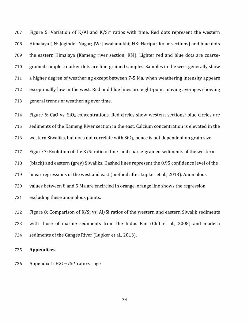
Figure 5: Variation of K/Al and K/Si* ratios with time. Red dots represent the western 707
Himalaya (JN: Joginder Nagar; JW: Jawalamukhi; HK: Haripur Kolar sections) and blue dots 708
the eastern Himalaya (Kameng river section; KM). Lighter red and blue dots are coarse-709
grained samples; darker dots are fine-grained samples. Samples in the west generally show 710
a higher degree of weathering except between 7-5 Ma, when weathering intensity appears 711
exceptonally low in the west. Red and blue lines are eight-point moving averages showing 712
general trends of weathering over time. 713
Figure 6: CaO vs. SiO2 concentrations. Red circles show western sections; blue circles are 714
sediments of the Kameng River section in the east. Calcium concentration is elevated in the 715
western Siwaliks, but does not correlate with SiO2, hence is not dependent on grain size. 716
Figure 7: Evolution of the K/Si ratio of fine- and coarse-grained sediments of the western 717
(black) and eastern (grey) Siwaliks. Dashed lines represent the 0.95 confidence level of the 718
linear regressions of the west and east (method after Lupker et al., 2013). Anomalous 719
values between 8 and 5 Ma are encircled in orange, orange line shows the regression 720
excluding these anomalous points. 721
Figure 8: Comparison of K/Si vs. Al/Si ratios of the western and eastern Siwalik sediments 722
with those of marine sediments from the Indus Fan (Clift et al., 2008) and modern 723
sediments of the Ganges River (Lupker et al., 2013). 724
Appendices 725
Appendix 1: H2O+/Si* ratio vs age 726

35
Appendix 2: XRD diffractograms of clays of similar age from west (red line) and east (blue 727
line), showing variations in the evolution of the clay mineralogy between west and east; 728
smectites are similar in the west and the east. 729
Table S1: Whole-rock major-element chemistry analyses of samples from the Joginder 730
Nagar, Jawalamukhi, and Haripur Kolar sections, Himachal Pradesh, northwestern India. 731