1 the next generation goes instruments: status and potential impact jim gurka team lead:...
TRANSCRIPT

1
The Next Generation GOES Instruments: Status and Potential Impact
Jim Gurka
Team Lead: Geostationary Spacecraft Requirements
NOAA/NESDIS/OSD

2
NWS Requirements: Top Priorities
– Continuous operations during eclipse & mitigation of Keep-out Zones
– Meet simultaneous global, synoptic and mesoscale data needs
– Improve the temporal and spatial resolution of the Imager
– Improve the spatial coverage of the Sounder

3
GOES Users’ Conference
– May 22 – 25, 2001
– Boulder, CO: NIST Auditorium
– Approximately 200 participants Government Commercial interests Academia Scientific organizations International

4
GOES Users’ Conference
– Goals: Inform users of future capabilities and applications Determine user needs for:
– New products
– Distribution of GOES data
– Data archiving and access to stored data
– Instruments of opportunity
– Access to sample data sets (prior to launch of next series)
– Future training
Assess user and societal benefits Improve communication between NESDIS and users

5
Proposed Instruments:
– Advanced Baseline Imager (ABI) 12 channel large focal plane array
– Advanced Baseline Sounder Michelson Interferometer with ~ 1500 bands

6
ABI
– 12 channel large focal plane array .5 km VIS resolution 2 km IR resolution 15 minute full disk coverage 5 minute CONUS coverage 1000 x 1000 km coverage/30 sec

7
ABI Channel Selection:
– 11.2: clouds, low level water vapor, fog, winds;– 0.64: daytime clouds, fog, aerosol, vegetation– 6.15: upper tropospheric flow, winds– 3.90: nighttime low clouds, fog, fire detection– 12.3: low level water vapor, volcanic ash– 13.3: cloud top parameters, heights for winds– 7.00: mid-tropospheric flow, winds– 1.61: daytime clouds/snow, water/ice clouds– 8.50: sulfuric acid aerosols, cloud phase, sfc– 10.35: cloud particle size, sfc properties– 0.86 : daytime clouds, fog, aerosols, NDVI– 1.375: daytime thin cirrus detection
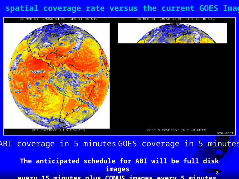
8
ABI spatial coverage rate versus the current GOES Imager
ABI coverage in 5 minutes GOES coverage in 5 minutes
The anticipated schedule for ABI will be full disk images
every 15 minutes plus CONUS images every 5 minutes.

9
19 January 2001, 1720 UTC MODIS 0.5 km
GOES-8 1 km
MODIS 0.25 km
MODIS 1 km
Lake Effect Snow Bands: Visible
GOES shows less contrast partly due to not being calibrated.

10
Severe convection: IR windows
25 February 2001
The simulated ABI clearly captures the over-shooting (cold) cloud tops, while the current GOES Imager does not.
Images shown in GOES projection.
MODIS (1 km) ABI (2 km)
GOES-8 (4 km)

11
Simulated ABI
Mountain Waves in WV channel (6.7 um) 7 April 2000, 1815 UTC
Actual GOES-8
Mountain waves over Colorado and New Mexico were induced by strong northwesterly flow associated with a pair of upper-tropospheric jet streaks moving
across the elevated terrain of the southern and central Rocky Mountains. The mountain waves appear more well-defined over Colorado; in fact, several aircraft
reported moderate to severe turbulence over that region.
UW/CIMSSBoth images are shown in GOES projection.

12
One minute and 30 second interval imagery of tornadic storms in Colorado & Kansas, May 31, 1996

13
GOES Visible Loop at 1 minute IntervalsGOES Visible Loop at 1 minute Intervals
July 24, 2000 severe weather July 24, 2000 severe weather outbreak across South Dakota outbreak across South Dakota and Nebraska produces hail, and Nebraska produces hail, tornadoes, flash flooding and tornadoes, flash flooding and damaging windsdamaging winds One minute interval visible One minute interval visible
imagery shows storm imagery shows storm evolution over 45 minute evolution over 45 minute period. Circle is 100 nmi in period. Circle is 100 nmi in diameter.diameter.
Imagery of this type being Imagery of this type being investigated with Doppler investigated with Doppler radar data to develop better radar data to develop better uses of satellite and radar uses of satellite and radar data for severe storm data for severe storm warningswarnings

14
The Eye of Hurricane Luis at 30, 15, 5 and 1 minute Intervals

15
ABI 10.35 m Channelvis, 10.5-11.0, and 8.6-10.5 um reveal utility of new IR window

16
GOES Users’ Conference Recommendations: Advanced Baseline Imager
– At least 12 Imager channels, but recommend additional 2 to 4 channels to meet requirements of large user cross section
– Full disk Imager coverage every 5 minutes

17
ABI Recommended Additional Channels:
High Priority – 0.47: aerosols, haze, slant range visibility;
– 9.60: ozone, clear air turbulence detection
Important…but also on ABS– 4.57: precipitable water;
– 14.2: improved cloud top heights

18
ABS:
– 5 times faster than present Sounder; Scan the region within 62 deg. of satellite zenith/ 1 hr
– (but only scan half the region of overlap between the east and west birds)
– 10 km horizontal resolution
– 1K, 10% RH accuracy/ .5km layer (sfc–500 hp)
– 1K, 10% RH accuracy/ 1-2 km layer (500-300 hp)
– 1K, 20% RH accuracy/1-2 km layer (300-100 hp)

19
ABS: Coverage

Geo-Interferometer Nears Raob-like Depiction of Atmospherewhile Providing an Order of Magnitude Increase in Temporal Resolution
over Land and Water
Information Content for Moist Atmospheres
0
2
4
6
8
10
12
14
16
12 18 18N 50N 2000 RAOB
Channels
Num
ber
of in
depe
nden
t Pie
ces
of
Info
rmat
ion
TemperatureMoisture
RAOB (USA) - over land - 1.5 hour ascent - 300 km separation - 12 Z and 00Z only
Geo Interferometer (USA) - land and coastal waters - instantaneous obs - 10 km separation - hourly repeat

Improvements in Retrievals Expected with Interferometers
Temperature errors less than 1 degree are needed and are only available from high spectral interferometers

Detection of Temperature Inversions Possible with Interferometer Capability
Spikes down - Cooling with height
Spikes up -Heating with height
The detection of inversions is critical for severe weather forecasting. Combined with improved low-level moisture information, the nocturnal jet can be monitored. Thismoisture transport is critical for nighttime severe storms development over the Plains.
Texas
Ontario
Bri
ghtn
ess
Tem
pera
ture
(K)
(low-level inversion)
(No inversion)

23
GOES Users’ Conference Recommendations: Advanced Baseline Sounder
– 4 km footprint needed for Sounder
– Rapid Scan option needed for Sounder
– Soundings needed in cloudy areas Soundings above cloud deck Supplement soundings with microwave from polar or Microwave soundings from Geo orbit

24
GOES Users’ Conference
– Goals: Inform users of future capabilities and applications Determine user needs for:
– New products
– Distribution of GOES data
– Data archiving and access to stored data
– Instruments of opportunity
– Access to sample data sets (prior to launch of next series)
– Future training
Assess user and societal benefits Improve communication between NESDIS and users

25
Summary: Benefits of ABI & ABS:
– Improved multi-spectral observation Improved observation of water vapor Improved cloud phase and droplet size information Improved satellite derived winds Improved observation of large scale flow Improved SST observation Improved depiction of stability Improved surface emissivity Improved QPE Improved mesoscale model performance

26
GOES Users’ Conference Recommendations: Suggested New Products:
– Atmospheric aerosols;– Cloud phase;– Cloud particle size;– Cloud optical depth;– Cloud emissivity;– Cloud layers;– Surface properties;– Moisture flux;

27
GOES Users’ Conference Recommendations: Suggested New Products:
– Improved volcanic ash product;– Improved QPE;– Improved satellite derived winds;– CAT threat;– Improved low cloud and fog product;– Probability of rainfall for each pixel;– Improved sea surface temperature product;– True color product;

28
GOES Users’ Conference Recommendations: Suggested New Products:
– Sulfur dioxide concentration;– Aircraft icing threat;– Ocean color;– Under (ocean) surface products;– Improved sea ice product;– Improved vegetation index;– Ozone layers;– Surface emissivity;

29
GOES Users’ Conference Recommendations:Instrument of Opportunity
– Lightning Mapper;
– Coastal Zone Remote Sensing Instrument;
– Microwave Sounder;
– Users recommend NOAA provide baseline funding for spacecraft accommodation costs;

30
GOES Users’ Conference Recommendations:Data and Product Archive Needs
– Need full spectrum of data from raw data to highly processed products, for applications from the global scale to the mesoscale;
User friendly Easy remote access Low cost Prompt user access Users need metadata Browse capability with request submission via Internet

31
GOES Users’ Conference Recommendations:New Data Integration
– Leverage data from relevant instruments on other satellites to better understand ABI and ABS;
Use AIRS and GIFTS to prepare for ABS Use MODIS to prepare for ABI Provide correctly formatted sample data sets at least one
year prior to launch; ID requirements for new algorithms by spring, 2002; Develop algorithms 3 to 5 years prior to launch;

32
GOES Users’ Conference Recommendations:User Education
– Comprehensive education program needed for: Forecasters; Emergency managers; Recreational users; Academia; Media; Industrial users; Commercial users

33
GOES Users’ Conference Recommendations:User Education
– Methods of education should include: Conferences and workshops; Web-based training; CD-ROM or DVD based training; Brief segments on the weather channel; Educational packages designed for Congress, upper
level management and business leaders;
– Education should be funded as part of the end-to-end GOES Program budget;

34
GOES Users’ Conference Recommendations: Communication with User Community
– Two way dialogue should continue between GOES User Community and NESDIS via:
Regular conferences, such as the GOES Users’ Conf. Working groups to deal with specific issues; Provide a Bulletin Board for information exchange; Informational special sessions at end user conferences; Provide information via e-mail; Make an expert team available to all users and
instrument developers;

35
GOES Users’ Conference
– See GOES User Conference Bulletin Board for input and questions from users:
http://www.osd.noaa.gov/GOES/feedback/asp
– See ftp site for Power Point Presentations:
ftp://140.90.233.11
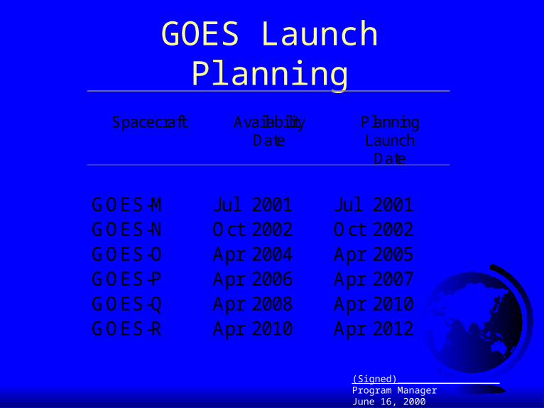
GOES Launch Planning
Spacecraft AvailabilityDate
PlanningLaunch
Date
GOES-M Jul 2001 Jul 2001GOES-N Oct 2002 Oct 2002GOES-O Apr 2004 Apr 2005GOES-P Apr 2006 Apr 2007GOES-Q Apr 2008 Apr 2010GOES-R Apr 2010 Apr 2012
(Signed)__________________Program ManagerJune 16, 2000

37
GOES Instrument Plans
GOES I- M GOES N, O, P GOES-Q GOES-R
ITT Imager ITT Imager ABI ABI
ITT Sounder ITT Sounder ITT Sounder ABS
SXI on GOES-M SXI on GOES-O SXI SXI – TBD
SEI on GOES-P

38
GOES Imager EvolutionGOES - QGOES - PGOES - OGOES - NGOES - MGOES - LGOES - 10GOES - 9GOES - 8Chan.
Vis
3.9
6.7
10.7
12
13.3
8 Km x 8 Km4 Km x 4 Km1 Km x 1 Km
10.7
12.0
13.3
1 x 1 km 4 x 4 km 8 x 8 km
Figure 1. GOES Imager Channels
Vis
3.9
6.7

39
Geostationary Satellite High Spectral Resolution Sounding Capabilities: Applications to Analysis/Forecasting:
• Improved environmental wind analyses for determining hurricane steering- More levels of motion, more accurate wind vector heights
• Superior water vapor detection- Identification of dry air intrusions- Low-level moisture
• Improvement in radiance and retrieved profile accuracy- Increased vertical resolution
• More precise measurements of sea surface temperatures- Hurricane intensity fluctuations
• All of the above will lead to improved forecast model initialization.

40
Eclipse Impact
– 2 eclipse seasons per year for each S/C 48 day period symmetric around equinox Earth disk blocks sunlight from solar array Requires shutdown of all instruments and loss of data for
up to 3 hours
– Next generation GOES: Improved batteries for operations during eclipse

41
Keep-out Zones
– Prevent instruments from pointing at sun Starts 10-15 days before eclipse season Ends 10 to 15 days after eclipse season
– Concern for instrument damage due to rapid heating
– Next generation GOES: improved mirror coating and better sun shield

Simulated Comparison of Current Sounder and ABS
UW-Madison/CIMSSNOAA/NESDIS/ORA/ASPT

GOES Sounder Spectral Coverage Current instrument has 18 infrared bands.
Future instrument will have more than 1500 infrared bands.
Higher spectral resolution leads to improved vertical resolving power.

44
UW/CIMSSMODIS (6.77um) GOES (6.75um)
A comparison of the water vapor images from the high-resolution NASA MODIS imager during the early assessment phase and the operational NOAA GOES imager. Both images have been remapped into a Mercator map projection.
NASA/GSFC
Preview of High Resolution Water Vapor Imagery using MODIS vs current GOES

45
01 September 2000-- Pre-burning
MODIS Detects Burn Scars in Louisiana
Burn Scars
Scars (dark regions) caused by biomass burning in early September areevident in MODIS 250 m NIR (channel 2--0.85 μm) imagery on the 17th.
CIMSS, UW MODIS Data from GSFC DAAC
17 September 2000-- Post-burning

46
Advances Possible with an Improved Geo - Sounder
A Geosynchronous Interferometer (Geo-I) will* depict water vapor as never before
- mesoscale features of moisture for short-term forecasting* characterize life cycle of clouds
- ice / water cloud- cloud particle sizes
(better cloud initializations within models)* measure surface temperatures (land and sea)
- improved SSTs * distinguish atmospheric constituents with improved certainty
- volcanic ash (useful for aircraft routing)
With complementary improved weather observing system, Geo-I* enables the best mix of observations of weather systems
Using improved NWP models, Geo-I provides* improved winds at more levels for hurricane intensity and trajectory forecasting* improved high resolution moisture / temp fields for QPF* improved cloud information with 4DVAR assimilation for better 2-3 day forecasts

47
GOES Users’ Conference
–General agreement that ABI, ABS, SEM & SXI will contribute to significant improvements in a wide range of applications including:
Aviation forecasting; Severe thunderstorm forecasting; Tropical cyclone analysis and forecasting; Marine forecasting; Generation of satellite derived winds; Satellite precipitation estimates; Space weather forecasting; Oceanographic and fisheries applications
Data from ABS will be necessary to initialize future high resolution numerical models;
Every effort should be made to leverage technology development from GIFTS for ABS development;

48
Benefits of New Imager Channels
–8.5: More accurate and consistent delineation of ice from water
cloud both day and night Thin Ci can be detected in conjunction with 11 SST estimates will be improved by better atmospheric
corrections in relatively dry atmospheres
–10.35: Cloud particle size & cloud liquid water content both day
and night Improved low level moisture determination (with 11.2 &
12.3 channels

49
Benefits of New Imager Channels
– 13.3: Improved determination of cloud height and opacity
– Improved satellite derived winds
– 1.61: Improved ability to distinguish cloud from snow and ice
cloud from water cloud (daytime only)
– 7.0: Better depiction of mid-tropospheric flow
– Improved moisture drift winds

50
Benefits of New Imager Channels
– 1.375: Daytime thin cirrus detection
– 0.86: Aerosols, ocean observation, vegetation