1 sustainable trails framework for planning
TRANSCRIPT

T R A I L P L A N N I N G , D E S I G N , A N D D E V E L O P M E N T G U I D E L I N E S
– 1.1 –
SECTION
M I N N E S O T A D E P A R T M E N T O F N A T U R A L R E S O U R C E ST R A I L S A N D W A T E R W A Y S
Framework for Planning Sustainable Trails 1OVERVIEW This section provides a foundation for trail planning and design. It considers:
• Common goals associated with trail development• Key planning and design concepts• Key factors in developing sustainable trails• Regulatory framework and grant program considerations• Publications that complement the guidelines• Trail planning relative to broader comprehensive/ resource management plans• Trail project planning guidelines
COMMON GOAL – A SUSTAINABLE TRAIL FUTUREAt the core of all trail planning is satisfying a trail user’s desires for a specifi c type of trail experience. Whether for recreation, fi tness, commuting, or utilitarian purposes, most trail users seek a fulfi lling outdoor experience that does not unduly harm the environment. Most trail users also appreciate that access to trails is a privilege and that each has a responsibility to preserve that access through proper use.
The primary goal of this publication is to provide a set of practical guidelines for planning and designing sustainable trails that will meet the needs of Minnesotans for generations to come. Other specifi c goals include:
• Promoting statewide consistency in how trails are classifi ed, planned, and designed • Promoting best practices to help ensure that all trail experiences are enjoyable,
safe, and sustainable, with minimal impacts to Minnesota’s natural resources • Promoting a high level of access to trails serving the many needs and physical
capabilities of trail visitors • Reducing costs through the use of practical, time-tested methods for developing
and maintaining trails
KEY TRAIL PLANNING AND DESIGN CONCEPTSA number of key concepts underpin the trail planning and design guidelines.
USING A COMMON LANGUAGE The guidelines establish a common language to foster consistency in classifying and developing trails across Minnesota.
SUSTAINABILITY FRAMEWORK The guidelines emphasize the development of physically and ecologically sustainable trails that will serve the needs of users for generations to come while preserving the sense of place and protecting the surrounding environment.
Minnesota’s parks and public lands offer many miles of enjoyable trails serving many needs within the context of long-term sustainability.

M I N N E S O T A D E P A R T M E N T O F N A T U R A L R E S O U R C E ST R A I L S A N D W A T E R W A Y S
– 1.2 – T R A I L P L A N N I N G , D E S I G N , A N D D E V E L O P M E N T G U I D E L I N E S
Minimizing the ecological impacts of trails, especially in sensitive areas
ECOLOGICAL SUSTAINABILITY
PHYSICAL SUSTAINABILITY
ENGENDERING STEWARDSHIP
Fostering a sense of individual responsibility for stewardship
Designing trails to retain their form over years of use and natural forces acting on them
KEY FACTORS FOR DEVELOPING SUSTAINABLE TRAILS Three key factors are common to all sustainable trails, as illustrated in the following diagram.
TRAILS MUST BE PLANNED TO ENGENDER STEWARDSHIP
Instilling a sense of ownership and responsibility with the public for stewardship of trails is a key ingredient of creating sustainable trails.
ALL TRAILS HAVE AN IMPACT
The placement of any trail on the landscape has an ecological impact. The challenge is to keep those impacts to a minimum while providing the desired trail experience. All trails should be conceived as low-impact recreational experiences with a built footprint only as needed.
ALL TRAILS CHANGE OVER TIME
Trail use promotes change. Trails must be designed in anticipation of changes to ensure that they remain relatively stable with appropriate maintenance and management. This is especially the case with natural trails.
TRAILS SUPPORT A WIDE VARIETY OF VISITOR CONTEXTS
All trails must be developed and managed for a desired set of specifi c visitor values and experiences deemed suitable for the site. These guidelines support a wide variety of trail and visitor experiences.
SUCCESSFUL TRAILS ARE A SEQUENCE OF EVENTS Trails offering a rich and continuous experience do not just happen. They are the result of thoughtful consideration of the site’s physical and scenic qualities and conscientiously using them to create a sequence of events that add interest, offer challenges, and exhibit scenic values that contribute to the trail experience.
Successful trails are designed at a detailed, intimate scale offering moment-to-moment experiences that bring visitors back again and again. The more a trail responds to the nuances of the site, the higher its value to the user. Even in cases where existing roads and rights-of-way are used for trail corridors, creating a sense of place and trail context are essential design objectives.
GUIDELINES ARE SPECIFIC TO MINNESOTA
The guidelines are based on the unique circumstances of Minnesota and may or may not be appropriate elsewhere.
For a trail to be sustainable, each of these factors must be considered in its planning, design, and development. The factors are also complementary, whereby trails that are the most physically sustainable also tend to be the most ecologically sustainable and appealing to use. This, in turn, encourages trail users to use trails appropriately and take personal responsibility for stewardship to ensure continued access for generations to come. This basic concept is fundamental to all trail development projects. The following provides additional context to each of these factors.
For a trail to be sustainable, each of these factors must be considered in its planning, design, and development. The factors are also complementary, whereby trails that are
Economic Sustainability
An important consideration in developing trails is ensuring that the implementing agency or trail advocacy group has the capacity to economically support it over its life cycle. Lacking this commitment, the prospects of maintaining a sustainable trail become suspect and the validity of developing the trail in the fi rst place becomes questionable. Developing a long-term maintenance strategy is a critical aspect of initial trail planning and fundamental to a successful trail program.
form over years of use and

T R A I L P L A N N I N G , D E S I G N , A N D D E V E L O P M E N T G U I D E L I N E S
– 1.3 –
Planning Sustainable Trails 1
M I N N E S O T A D E P A R T M E N T O F N A T U R A L R E S O U R C E ST R A I L S A N D W A T E R W A Y S
Trail experience is the attraction!
Trail experience and destination are the attractions!
Visitor motivation: Trail experience and sense of place are major reasons to use the trail. The richer the experience, the more visitors will enjoy the trail and work to preserve and protect it and the surrounding landscape. Adding a destination to the trail experience increases its value to the visitor.
Stewardship potential: Detailed trail design plays a major role in creating a stewardship ethic. The richer the trail experience, the higher the potential to entice the visitor to take personal responsibility to protect it.
Destination is the attraction!
Visitor motivation: If the trail is used primarily as a transportation route to a destination, it will be fi rst judged on whether it provides or hinders expedient travel. Length and directness of the route and tread quality are primary visitor motivations for using the trail. The trail experience can still be appreciated, but only as long as it does not confl ict with expedience in reaching the destination.
Stewardship potential: Engendering stewardship is more of a challenge because visitors are not inherently focused on the trail experience. Stewardship is often indirectly achieved by designing the trail to avoid putting users in direct confl ict with sensitive ecological areas and avoiding the temptation for short-cutting.
STEWARDSHIP POTENTIAL BASED ON VISITOR MOTIVATION
PHYSICAL SUSTAINABILITY
Designing trails to retain their physical form over years of use and natural forces acting on them is a major theme of these guidelines. The specifi c guidelines defi ned in this manual related to a trail’s classifi cation, general and technical design, and stewardship are all focused on developing trails that are physically sustainable.
ECOLOGICAL SUSTAINABILITY
Minimizing the ecological impacts of trails, especially in sensitive areas, is also a major theme of these guidelines. Section 3 – Principles of Ecological Sustainability provides the essential underpinning for developing trails that are enjoyable to use without diminishing the environment and sense of place in the process.
ENGENDERING STEWARDSHIP A sense of individual responsibility for stewardship is fostered when trail users:
• Use trails in an appropriate manner • Avoid impacts to surrounding ecological systems • Educate others about sustainable ethics and practices
Since people protect what they value, stewardship can only be engendered when trails are designed with a full understanding of a visitor’s motivations for using them, as the following diagram considers.
The essence of engendering trail stewardship is creating a rich experience without losing sight of the primary motivation for a visitor to use the trail. Even where getting to a destination is the primary reason to use a trail, the more it is designed to be a rewarding experience, the more likely the user will feel responsible to protect it.
Engendering stewardship also requires an inclusive public process where all stakeholders have the opportunity to participate in a meaningful way and where outcomes truly refl ect the needs and concerns of those the trail is intended to serve.

M I N N E S O T A D E P A R T M E N T O F N A T U R A L R E S O U R C E ST R A I L S A N D W A T E R W A Y S
– 1.4 – T R A I L P L A N N I N G , D E S I G N , A N D D E V E L O P M E N T G U I D E L I N E S
REGULATORY FRAMEWORK – A KEY CONSIDERATION As with all forms of development in Minnesota, there are specifi c regulatory and permitting requirements associated with trails. Most of these relate to protecting Minnesota waters and wetlands. The following is a listing of the most common regulatory requirements that should be reviewed to determine their pertinence to the development of any given trail. The list is not, however, comprehensive.
DNR DIVISION OF TRAILS AND WATERWAYS The DNR Division of Trails and Waterways (www.dnr.state.mn.us/trails_waterways) is the clearinghouse for information related to state trails throughout Minnesota. The division is an especially important source of information on off-highway vehicle (OHV) riding, as well as the latest information on managing and restoring natural communities along trails. The division also administers many trail grant programs. Specifi c requirements for those seeking trail grants can be found on the Division’s website (www.dnr.state.mn.us/grants/index.html).
DNR DIVISION OF WATERS The DNR Division of Waters (www.dnr.state.mn.us/waters) is a key source of information related to permit requirements associated with development across or near public waters and wetlands, including trails. This includes information on how the Public Waters Work Permit programs relate to requirements associated with the Wetland Conservation Act and Section 404 of the Clean Water Act and related information and management recommendations/requirements. The link to “Do I Need a Permit?” is particularly useful to understanding specifi c permit requirements.
Particular attention should be given to the Public Waters Work Permit that is administered through this division and relates to state waters (lakes, wetlands, and streams) that are mapped out and identifi ed on county-based Public Water Inventory maps. These waters are separate from the wetlands protected by the Wetland Conservation Act, and include lakes and wetlands of more than 10 acres in unincorporated areas, and of more than 2.5 acres in incorporated areas. Streams having a total drainage area of more than 2 square miles and designated trout streams of any drainage area are also subject to the provisions of this program. This program was initially enacted in 1937 with the goal of protecting surface waters while providing for reasonable riparian access and use. See the website for more information and access to Public Water Inventory maps and lists, application form information, and more.
DNR DIVISION OF ECOLOGICAL SERVICES
The DNR Division of Ecological Services (www.dnr.state.mn.us/ecological_services) collects, analyzes, and delivers vital ecological information to Minnesota citizens, leaders, and decision makers. With respect to trail development, the division administers Minnesota’s endangered species law, which imposes a variety of restrictions, a permit program, and several exemptions pertaining to species designated as endangered or threatened. Persons involved in trail development are advised to read the full text of the statute and rules in order to understand all regulations pertaining to species that are designated as endangered, threatened, or species of special concern.
LOCAL AGENCIES AND UNITS OF GOVERNMENT The local soil and water conservation district (www.bwsr.state.mn.us/directories/index.html) is a clearinghouse for information related to protecting Minnesota waters and wetlands. The soil and water conservation district is a key source of information relating to the requirements of the Wetland Conservation Act. Each of the listed governmental entities has specifi c roles and permit requirements related to protecting local land and water resources. The local unit of government should be the fi rst agency contacted to determine specifi c permit requirements for a given trail development.
U.S. ARMY CORPS OF ENGINEERS Through Section 404 of the Clean Water Act, the U.S. Army Corps of Engineers (www.mvp.usace.army.mil/regulatory) has oversight of navigable bodies of water. Understanding which bodies of water this encompasses is important in trail planning. Refer to corps mapping whenever trails are near these areas.
Simplifying the regulatory process!
In Minnesota, a number of regulatory agencies created a common application form for water/wetland- related projects entitled Minnesota Local/State/Federal Application Forms for Water/Wetland Projects. This ensures a consistent approach to evaluating the need for specifi c permits associated with trail development in sensitive environments. This permit application covers local government units, MN DNR, U.S. Army Corps of Engineers and MPCA 401 Certifi cation. However, this common application form is not used as the MPCA application for the NPDES Construction Stormwater Permit.
The DNR Division of Waters (www.dnr.state.mn.us/waters) is a key source of
Waters Work Permit programs relate to requirements associated with the Wetland Conservation Act and Section 404 of the Clean Water Act and related information and

T R A I L P L A N N I N G , D E S I G N , A N D D E V E L O P M E N T G U I D E L I N E S
– 1.5 –
Planning Sustainable Trails 1
M I N N E S O T A D E P A R T M E N T O F N A T U R A L R E S O U R C E ST R A I L S A N D W A T E R W A Y S
Section 404 of the Clean Water Act establishes a program to regulate the discharge of dredged and fi ll material into waters of the United States, including wetlands. The basic premise of the program is that no discharge of dredged or fi ll material can be permitted if a practicable alternative exists that is less damaging to the aquatic environment or if the nation’s waters would be signifi cantly degraded. When applying for a permit, the permittee must show that steps to avoid wetland impacts where practicable and compensation for any impacts was provided through restoration activities and/or creating new wetlands. Refer to the corps website for more information on permits.
MINNESOTA POLLUTION CONTROL AGENCY (MPCA)Minnesota’s lakes, rivers, forests, and farms all depend on the replenishing waters of annual precipitation. Stormwater runoff can change both water quality and quantity affecting state water resources physically, chemically, and biologically. The Minnesota Pollution Control Agency’s (MPCA’s) Stormwater Program is designed to reduce the pollution and damage caused by stormwater runoff. Mandated by Congress under the Clean Water Act, the National Pollutant Discharge Elimination System (NPDES) Stormwater Program is a comprehensive national program for addressing polluted stormwater runoff. Minnesota regulates the disposal of stormwater through State Disposal System (SDS) permits. MPCA issues combined NPDES/SDS permits for construction sites, industrial facilities and municipal separate storm sewer systems (MS4s). Information on NPDES Stormwater Construction Permit requirements can be found on the MPCA website (www.pca.state.mn.us/publications/wq-strm2-51.doc)
Another standard to be aware of is MPCA Water Quality Standards in Minnesota Rules Chapter 7050 (www.revisor.leg.state.mn.us/bin/getpub.php?pubtype=RULE_CHAP&year=current&chapter=7050). Parts 7050.0130 to 7050.0227 apply to all waters of the state, both surface and underground, and include general provisions applicable to the maintenance of water quality and aquatic habitats; defi nitions of water use classes; standards for dischargers of sewage, industrial, and other wastes; and standards of quality and purity for specifi c water use classes. This chapter applies to point source and nonpoint source discharges and to physical alterations of wetlands. These water quality standards regarding the protection of all waters/wetlands and wetland alteration are applied to the MPCA determination of compliance with water quality standards in the issuance of the Construction Stormwater NPDES Permit and the issuance of the Clean Water Act Section 401 Certifi cation as part of the U.S. Army Corps of Engineers Section 404 permitting. More information regarding the MPCA 401 Certifi cation may be found at (www.pca.state.mn.us/water/401.html )
ENVIRONMENTAL QUALITY BOARD (EQB)The Environmental Quality Board (EQB) draws together the chair, fi ve citizens, and the heads of nine state agencies that play a vital role in Minnesota’s environment and development. The board develops policy, creates long-range plans, and reviews proposed projects that would signifi cantly infl uence Minnesota’s environment. Refer to the Minnesota Environmental Review Rules (Minnesota Rules Chapter 4410) at the EQB’s website (www.eqb.state.mn.us) for regulatory requirements that may relate to trails.
Pursuant to these rules, some trail development projects may undergo an Environmental Assessment Worksheet (EAW). The EQB adopted rules establishing new mandatory EAW and exemption categories for certain types of recreational trails in October 2005. The rules can be accessed through the Statutes and Rules link on the EQB’s website. The specifi c citations for the recreational trail sections are: mandatory EAW category – part 4410.4300, subpart 37; exemptions category – part 4410.4600, subpart 27.
If the responsible government unit (RGU) decides that a project has the potential for signifi cant environmental impacts, a more detailed Environmental Impact Statement (EIS) may be required. Environmental review must be completed before a trail project is implemented.
MINNESOTA STATE HISTORICAL SOCIETY (MHS) The Minnesota Historical Society (MHS) (www.mnhs.org/index.htm) and the State Historic Preservation Offi ce (SHPO) can help determine if the development of a trail impacts any cultural or historical elements that may require documentation and protection. Refer to the MHS website for any specifi c requirements regarding preserving these resources across the state.
This is relatively new!
Be aware of the EQB rule changes as of October 2005.
Environmental Assessment Worksheet (EAW). The EQB adopted rules establishing new mandatory EAW and exemption categories for certain types of recreational trails in October 2005. The rules can be accessed through the Statutes and Rules link on the EQB’s website. The specifi c citations for the recreational trail sections are: mandatory EAW category – part 4410.4300, subpart 37; exemptions category – part 4410.4600, subpart 27.

M I N N E S O T A D E P A R T M E N T O F N A T U R A L R E S O U R C E ST R A I L S A N D W A T E R W A Y S
– 1.6 – T R A I L P L A N N I N G , D E S I G N , A N D D E V E L O P M E N T G U I D E L I N E S
GRANT PROGRAM CONSIDERATIONS The DNR and other public agencies offer a number of grant programs for trails, each of which has specifi c requirements. The following references are listed to encourage trail planners to become familiar with these programs and to underscore that a variety of funding programs are available for trail development across the state.
DNR TRAIL GRANT PROGRAMS
The DNR Division of Trails and Waterways administers a number of trail-related grant programs for a variety of trail types, including (but not necessarily limited to):
• OHVs), including all-terrain vehicles (ATVs), four-wheel drive vehicles (ORVs), and off-highway motorcycles (OHMs)
• Cross-country skiing and snowmobiles • Local trail connections • Regional trails
The division also administers the federal recreational trail grant programs. Refer to the website (www.dnr.state.mn.us/grants/recreation/index.html) for the most up-to-date information on program offerings and submittal requirements.
LEGISLATIVE CITIZEN’S-COMMISSION ON MINNESOTA RESOURCES (LCCMR)The Legislative Citizen’s-Commission on Minnesota Resources (LCCMR) is a bipartisan commission that makes funding recommendations to the Legislature for special environmental and natural resource projects. Matching grants are provided under this commission for local and regional trails (administered by DNR Division of Trails and Waterways) and Metropolitan Regional Parks and Trails (administered by the Metropolitan Council). Proposals for each of these are submitted directly to the administrating agency. Additional information can be found on the two agencies’ websites. (LCMR at www.commissions.leg.state.mn.us/lcmr and DNR at www.dnr.state.mn.us/grants/recreation/index.html)
MINNESOTA DEPARTMENT OF TRANSPORTATION (MN/DOT) PROGRAMS
The Minnesota Department of Transportation (Mn/DOT) administers a variety of trail-related state and federal grant programs. Refer to the website (www.dot.state.mn.us/library/bike_peds.html) for the most up-to-date information on program offerings and submittal requirements.
PUBLICATIONS THAT COMPLEMENT THE GUIDELINESThere are a number of trail-related publications that complement these guidelines, some of which are referenced in other sections. Many of the publications have relevance to specifi c trail issues, such as accessibility, that require greater detail than can practically be provided here. Note that this list is limited to publications that seem to have the greatest value in complementing what is provided in this manual. Trail planners and designers are encouraged to retain a copy of the relevant publications to become familiar with their content and application to specifi c types of trail projects.
MN/DOT BIKEWAY FACILITY DESIGN MANUAL This Mn/DOT manual complements these guidelines, with the most recent update completed in 2006. The manual has particular relevance to on-road bikeways, where it is the de facto standard referenced for bike lanes and bike routes as described in these guidelines. The manual can be found at website www.dot.state.mn.us/transit/bike/bikedesign.html. The Mn/DOT Manual and these guidelines also reference the 1999 AASHTO Guide for the Development of Bicycle Facilities, a common technical design standard for shared-use paved trails.
ACCESSIBILITY-RELATED PUBLICATIONS AND WEBSITES
The United States Access Board is a commonly referenced resource for up-to-date information on accessibility, including trails. The ADA Accessibility Guidelines for Buildings and Facilities (ADAAG) can be found at www.access-board.gov/adaag/html/adaag.htm. Several other publications also provide valuable information on accessibility guidelines, including the following.
Stay abreast of grant opportunities!
All providers of trails are encouraged to submit applications to the various grant programs to take advantage of funding opportunities that can leverage local matching funds.
The DNR and other public agencies offer a number of grant programs for trails, each of which has specifi c requirements. The following references are listed to encourage trail
funding programs are available for trail development across the state.

T R A I L P L A N N I N G , D E S I G N , A N D D E V E L O P M E N T G U I D E L I N E S
– 1.7 –
Planning Sustainable Trails 1
M I N N E S O T A D E P A R T M E N T O F N A T U R A L R E S O U R C E ST R A I L S A N D W A T E R W A Y S
A good reference to have on hand!
This brochure is a quick guide for designing accessible sidewalks and trails and is worth having for reference.
DESIGNING SIDEWALKS AND TRAILS FOR ACCESS
This is an exhaustive two-part publication that covers virtually every aspect of accessible sidewalks and trails and complements the guidelines provided in this manual. The publication has particular application to the detailed aspects of curb ramps, pedestrian crossings, and sidewalks. This and other related information can be found on the FHWA general safety website (safety.fhwa.dot.gov/index.htm).
A more handy accessibility guideline is a foldout brochure entitled Accessible Sidewalks and Street Crossings – On the Safe Side published by the U.S. Department of Transportation Federal Highway Administration (FHWA). The publication number is FHWA -SA-03-017; it can be found at safety.fhwa.dot.gov/ped_bike.htm. This brochure covers day-to-day accessibility issues associated with trails and sidewalks and is a worthwhile tool to have for quick reference.
UNIVERSAL ACCESS TO OUTDOOR RECREATION (PUBLISHED BY PLAE, INC.)This publication focuses on accessibility to outdoor recreation, including trails, based on different needs and expectations of potential users. While the publication focuses on providing access to all, it also recognizes that the level of accessibility is relative to the setting. It is a worthwhile reference book to have on hand.
VOLUNTARY SITE-LEVEL FOREST MANAGEMENT GUIDELINES Published by the Minnesota Forest Resources Council, Voluntary Site-Level Forest Management Guidelines covers virtually all aspects of forest management by homeowners, loggers, and resource managers. Although it has particular relevance to trail planning in the northern part of the state, it is a worthwhile publication that trail planners should have available for reference. The guidelines are available at www.frc.state.mn.us/FMgdline/Guidebook.html.
GUIDELINES FOR MANAGING NATURAL PLANT COMMUNITIES DNR Guidelines For Managing And Restoring Natural Plant Communities Along Trails And Waterways provides an easy-to-understand approach to restoring and managing natural areas associated with trails and are a worthwhile reference to have on hand as a resource. The guidelines are at www.dnr.state.mn.us/trails_waterways/naturalcommunities/index.html.
GUIDELINES FOR OHVS
The publication Park Guidelines for OHVs (published by the National Off-Highway Vehicle Conservation Council (NOHVCC) and George Fogg, FASLA) provides a broad-based discussion on OHV trail planning and complements the guidelines presented in this manual. It is a general reference that may be of value in the detailed design of OHV trails. It is available through the NOHVCC website (www.nohvcc.org).
GUIDELINES FOR MOUNTAIN BIKE TRAILS The publication Trail Solutions – IMBA’s Guide to Building Sweet Singletrack (published by the International Mountain Biking Association (IMBA)) provides user-friendly guidelines on planning and developing high-quality mountain bike trails.
DNR SIGN MANUAL This manual covers all of the signs used by the DNR for trails and other purposes. The manual is available on the DNR’s website (www.dnr.state.mn.us).
MN/DOT SIGN MANUAL The Minnesota Manual on Uniform Traffi c Control Devices (MN MUTCD) is the primary reference for general traffi c control and safety sign standards. Part 9 – Traffi c Control Devices for Bicycle Facilities and Appendix C – Sign Listing are particularly useful.
FOREST ACCESS – SIGNING AND PLACEMENT OF GUIDELINES The DNR Division of Trails and Waterways has developed a sign manual for forest access roads and trails as related to OHV uses. Refer to www.dnr.state.mn.us/trails_waterways/index.html for the most up-to-date information on this manual.

M I N N E S O T A D E P A R T M E N T O F N A T U R A L R E S O U R C E ST R A I L S A N D W A T E R W A Y S
– 1.8 – T R A I L P L A N N I N G , D E S I G N , A N D D E V E L O P M E N T G U I D E L I N E S
TRAIL PLANNING RELATIVE TO BROADER RESOURCE MANAGEMENT AND COMPREHENSIVE PLANSThe development of trails and trail systems should be consistent with broader resource management and comprehensive plans prepared by local, regional, state, and federal agencies with various types of land use authority. The following provides an overview of the most common of these plans as related to trails.
LOCAL COMPREHENSIVE PLANS
All local city, township, and county jurisdictions develop comprehensive plans that cover all aspects of community development and land use. Typically, this includes a parks, open space, and trail system component, albeit with varying degrees of detail. These plans should be reviewed as part of any local trail development. Contact the parks and recreation, planning, or natural resources departments of the local governing unit (LGU) for more information on local trail systems plans and development standards.
REGIONAL PARKS AND TRAILS PLAN The Twin Cities area’s nationally renowned system of regional parks and trails contributes significantly to Minnesota’s high quality of life. Preserving green space for wildlife habitat and recreation enhances the region’s livability and thus its economic strength. Parks and trails within the system are operated by several partnering cities and counties. These local agencies work with the Metropolitan Council on acquisition and development, protecting natural resources, and providing outdoor recreation for public enjoyment. The council also works with these partners to develop policies that protect the region’s water quality, promote best management practices, and help integrate the park and trail systems with housing, transportation, and other regional priorities. More information is available at www.metrocouncil.org/parks/parks.htm.
STATE PARKS AND TRAIL PLANS
DNR Division of Trails and Waterways is responsible for planning, operating, and managing state trails, public water access sites, piers and shore-fishing sites, and canoe and boating routes. Through grants-in-aid funding with local units of government, the division administers snowmobile, OHV, and cross-country ski trails. It also provides financial and technical assistance to local units of government and organized interest groups. More information about the division’s oversight of state trails and related programs can be found at www.dnr.state.mn.us/trails_waterways/index.html.
There are also numerous other divisions within DNR that may need to be contacted for specific trail-related projects, including Ecological Services, Enforcement, Fish and Wildlife, Forestry, Lands and Minerals, Parks and Recreation, and Waters. More information is available at www.dnr.state.mn.us/sitemap/index.html.
FOREST/PUBLIC LANDS RESOURCE MANAGEMENT PLANS Local counties, the DNR, and the U.S. Forest Service (USFS) have responsibility to develop and implement resource management plans for county, state, and federal lands, respectively. These plans typically focus on managing timber harvests, forest health, scenic qualities, and public access and enjoyment. The latter typically includes policies related to the use of roads and trails for recreational purposes, especially OHV uses. Notably, these policies may vary, sometimes considerably, from agency to agency. Always contact local offices of these agencies prior to any trail planning or development that may directly or indirectly affect the lands under their jurisdiction. Minnesota is in the Eastern Region (R9) of the USFS system; more information is available at www.fs.fed.us/r9.
METHODS FOR DEFINING NATURAL AREAS/SENSITIVE ECOLOGICAL SYSTEMS The latter part of Section 3 – Principles of Ecological Sustainability provides an extensive overview of methods for defining natural areas and sensitive ecological systems, including rare and endangered species. Refer to this section for specific resources and publications available through various agencies, especially the DNR.

T R A I L P L A N N I N G , D E S I G N , A N D D E V E L O P M E N T G U I D E L I N E S
– 1.9 –
Planning Sustainable Trails 1
M I N N E S O T A D E P A R T M E N T O F N A T U R A L R E S O U R C E ST R A I L S A N D W A T E R W A Y S
TRAIL PROJECT PLANNING GUIDELINES Sustainable trails are a result of a well-thought-out process that brings stakeholders together to fi nd the best solution within the context of site opportunities and constraints. The process must also accommodate regulatory and permitting requirements to ensure that trails will be physically and ecologically sustainable.
Project planning is typically a multiple-step process from initial inception through development, management, and maintenance. The guidelines provide a checklist of essential elements to consider when planning and developing a sustainable trail. Typical steps in the process include:
• Step 1 – Project proposal and stakeholder involvement • Step 2 – Public notifi cation and comment • Step 3 – Environmental review • Step 4 – Trail design and construction documents • Step 5 – Project permitting • Step 6 – Management, monitoring, and stewardship (maintenance)
These steps consider the typical requirements of common grant applications. If grant funding is being sought follow the specifi c requirements the program.
The following considers each of these steps in greater detail.
STEP 1 – PROJECT PROPOSAL AND STAKEHOLDER INVOLVEMENT
The proposal defi nes the trail project in suffi cient detail to ensure that interested and affected parties and regulatory agencies can understand the type and scope of the trail being proposed. Common components of a project proposal include:
VISION STATEMENT The vision consists of a straightforward description of the type of trail envisioned, user group(s) to be served, benefi ts, and the desired visitor experience. The statement should clearly defi ne the project’s intent.
PROGRAM STATEMENT
The program statement is a collection of thoughts, ideas, and factors that will infl uence the planning and design of a trail. It is essentially a shopping list that is used throughout the planning process to ensure that the fi nal plan addresses all pertinent issues. The program statement is dynamic, meaning it can change and evolve as new information or perspectives are considered.
Items typically included in the program statement include the following:
Project Expectations
An expectations statement should be prepared for each stakeholder defi ning the group’s or individual’s vision of success (within the context of the larger vision). These statements can be valuable in tailoring the planning process to emphasize the issues of most importance to stakeholders.
Past Plans Affecting the Trail
All previously prepared plans identifi ed by stakeholders should be reviewed for relevance. The fi nal trail plan should include reference to any existing plans that affect planning outcomes.
Restricted or Permitted Uses
Any restrictions associated with the type of trail allowed within a specifi c area should be thoroughly investigated early in the process. An initial listing of all required permits should also be included.
Base Mapping
Accurate base mapping signifi cantly affects the completeness and quality of the planning and design documents. The box on the next page highlights the essential aspects of a site survey.
Planning guidelines note!
The guidelines presented in this section are general. Projects seeking grants or requiring regulatory approval should adhere to the specifi c requirements of the administering agency or agencies.
together to fi nd the best solution within the context of site opportunities and constraints. The process must also accommodate regulatory and permitting
development, management, and maintenance. The guidelines provide a checklist of
Regulatory framework!
Refer to the regulatory framework provided in this section as an initial starting point for defi ning permitting requirements.
Any restrictions associated with the type of trail allowed within a specifi c area should
should also be included.
Accurate base mapping signifi cantly affects the completeness and quality of the planning and design documents. The box on the next page highlights the essential aspects of a

M I N N E S O T A D E P A R T M E N T O F N A T U R A L R E S O U R C E ST R A I L S A N D W A T E R W A Y S
– 1.10 – T R A I L P L A N N I N G , D E S I G N , A N D D E V E L O P M E N T G U I D E L I N E S
A PLANNING ESSENTIAL: AN ACCURATE SITE SURVEY An accurate site survey and analysis are important to the planning process and as much detailed information as reasonably available should be gathered. This consists of a variety of maps, including general base mapping (preferably in GIS format) where multiple overlays of information can be illustrated. Aerial photography (black and white, color, and other forms as available) is also a valuable planning tool. Photos should also be taken from the ground at various vantage points to record site conditions. The following provides an overview of the information that should be included in the site survey and analysis graphic. The level of detail needed depends on the circumstances and the size and scale of the project.
Topography: Relates to grades, elevations, and drainage patterns across the site. Topographic maps typically provide contours on a 2-foot basis. The character and extent of undulation should be graphically illustrated on the site analysis graphic.
Surface Water and Hydrology: Understanding surface water patterns and hydrological fl ows is critical to designing sustainable trails. The base mapping and site analysis graphic should illustrate:
• Lakes and ponds• Wetlands• Ephemeral wetlands• Rivers, streams, and ephemeral streams• Floodplains• Wet meadows and wet slopes• Springs and seeps• Drainages and drainage channels
All drainage channels should be identifi ed given their infl uence on erosion issues, especially for natural surface treads. The size and minimum/maximum normal fl ow rates and/or water levels should be estimated for each of the items listed above.
Ecologically Sensitive Areas/Vegetative Inventory: Defi ning ecologically sensitive areas through a vegetative inventory and land classifi cation is one of the most important aspects of designing trails that are sustainable. (The common methods for doing this are defi ned in Section 3 – Principles of Ecological Sustainability.) In all cases, sensitive ecological systems should be defi ned to a level necessary to understand the system and protect its integrity during the planning process. Specifi c items to identify and avoid impacts to include:
• Critical habitat of endangered, threatened, and special concern species
• Rare, unique, contiguous, or high-value natural areas • Patches of high-quality and unique habitat• Riparian areas• Migratory routes or seasonal use areas for wildlife
Soils: An understanding of soil types where the trail will traverse is important to creating a sustainable trail. This is especially the case with natural surfaced trails, where erosion can be a particular problem. The soil analysis should include:
• Soil types using standard practices; broad characterization (loam, sandy loam, silty loam, sandy clay, etc.) is suffi cient for initial planning
• Identifi cation of areas of particular instability or erosion potential as related to the intended use
A more detailed soil study is often needed for load-bearing paved trails and natural surface trail treads where erosion is a major concern.
Property Boundaries and Adjacent Land Uses: Property boundaries and any public or private easements should be recorded on the survey. Identifi cation of current or anticipated adjacent land uses is also important, including how those uses complement or confl ict with the trail. All covenants that may exist for the property or adjacent properties should also be recorded.
Administrative Boundaries and Jurisdictions: All special management areas or other jurisdictional boundaries should be recorded as part of the site analysis. This is especially important with respect to resource and wildlife management areas and areas set aside as wilderness or other protective designation.
Distinct Site Edges: On the site analysis, distinct edges of ecologically sensitive areas, water features, or landforms should be identifi ed. These areas tend to be interesting features that could serve as highlights along the trail (within a sustainable context). Existing Site Features and Anchors: These are physical features of the landscape that would add interest to the trail experience. The site analysis should identify all anchors that could be integrated into the trail design to make for a richer trail experience. Known or potential points of interest, scenic views, recreational use areas, destinations, and so on should all be identifi ed as part of the site analysis.
Cultural Sites: The entire site should be assessed for cultural or historic features that may infl uence the location of a trail and/or provide a point of interest. This includes European and Native American/tribal cultural site reviews.
Existing Developed/Disturbed Areas: The site analysis graphic should identify all developments on the site and other areas that have been previously disturbed, including:
• Trails, including closed, abandoned, and decommissioned with current use, condition, and estimated level of sustainability defi ned
• Trailheads and trail access points • Roads of any type or usage, including abandoned roads
(the potential to reuse abandoned roads as part of the trail corridor should be identifi ed)
• Railroads and abandoned railroad grades • Utility corridors• Facilities, agricultural operations, buildings, structures,
parking areas, campsites, and other human works• Environmentally disturbed areas (mine sites, dump sites,
transportation corridors, etc.)• Any known locations where existing development or
disturbance is causing: – Erosion – Sedimentation into waterways – Wildlife habitat disruption – Fish habitat disruption – Nonnative plants or noxious weeds
Hazardous Situations: Areas prone to fl ooding should be identifi ed, including ordinary high water (OHW) level. Unstable or steep slopes should be identifi ed. Any potentially hazardous adjacent land uses should also be recorded, as should hazards posed by operations such as mining, agriculture, railroads, and highways on adjacent land.
Construction/Maintenance Access: All points of access for trail construction and maintenance should be identifi ed on the site analysis.

T R A I L P L A N N I N G , D E S I G N , A N D D E V E L O P M E N T G U I D E L I N E S
– 1.11 –
Planning Sustainable Trails 1
M I N N E S O T A D E P A R T M E N T O F N A T U R A L R E S O U R C E ST R A I L S A N D W A T E R W A Y S
Planning and Design Issues
The following box highlights the essential planning and design issues to be considered in establishing a clear basis and rationale for a trail.
TRAIL-RELATED PLANNING AND DESIGN ISSUES A well-written program statement defi ning the planning and design issues associated with the development of a trail for a specifi c purpose is essential to establishing the base-line rationale for the project. It also provides an opportunity to defi ne project constraints that are best addressed early in the process, when they can be proactively considered and acted upon.
Trail Type Being Proposed: The type of trail being proposed should be clearly defi ned, including its specifi c trail classifi cation.
Basic Set of Justifi cations: A basic set of justifi cations should be established for the trail. Questions to be answered include:
• Why have this type of trail in this location? • Who are the primary user groups and where will they be
coming from? • Will the trail be single use or multiuse?• What purposes does the trail serve (recreation,
transportation to a destination, etc.)?• Who benefi ts from the trail, and who or what will be
adversely affected by it?• How can sensitive ecological areas be avoided, minimized,
and/or interpreted?• What kinds of recreational experience will the trail and site
offer?• What types and amount of trail use can be expected and
sustained?• If this trail were not formally designed and constructed,
would visitors eventually form a new and potentially damaging trail anyway?
• Where does the trail go? Is the destination signifi cant? Does it link existing or planned recreation facilities?
• Is this a reroute, reconstruction, or entirely new trail?• What noteworthy or developed features can be found on or
near this trail?• What type of trail surfacing options need to be considered,
given site conditions?• Is all or part of the trail to be accessible?
Basic Site Characteristics: Highlighting the site attributes that will be used to create a rich and varied trail experience is an important initial planning step. This is most often accomplished in both written and graphic form. Site attributes to be identifi ed include:
• Landscape features offering scenic values, places of interest, local landmarks, trail challenges, etc.
• Control points such as unique landscape features, viewing points, and site constraints that might limit access
• Ecologically sensitive areas• Less sensitive areas where trail impacts are less • Basic topography• Soils and vegetation• Site drainage characteristics• Nearby roads, trails, and adjacent land ownership patterns • Legal and administrative boundaries, right-of-way width• Current uses of the site and adjacent areas• Trails or destinations to which proposed trail(s) may connect• Areas to screen or feature associated with adjacent sites• Other site features as applicable
Intrinsic Qualities: This relates to how the various site elements collectively create a compelling and enjoyable experience for the trail visitor. Asking the following questions helps defi ne these qualities:
• What is the sense of place being exhibited and preserved? • How “rich” is this site in terms of varied or dramatic
landforms and spatial diversity? Where are the richest areas and what makes them rich?
• What kind of trail experience is desired? What kind of experience can the site reasonably sustain?
Engendering Stewardship: Eliciting individual responsibility for stewardship of the trail is vital to its long-term sustainability. At the program level, ways in which stewardship can be encouraged should be defi ned. Examples include establishing a:
• Formal volunteer trail group for promoting and maintaining the trail
• Communication plan to promote the trail and sustainable use practices
• Trail signage program that includes a stewardship component
Potential Confl icts and Limitations: All potential confl icts and limitations should be clearly stated in the program statement, including anticipated action to resolve them. No confl ict should ever be ignored since it will likely come back around when the trail is to be developed. An inclusive planning process helps in overcoming apparent constraints and obstacles.
Accessibility: The level of accessibility envisioned should be clearly defi ned relative to the type of trail being proposed and site constraints that might affect grades and other accessibility issues. Interconnectiveness with other trails and facilities should also be defi ned.
Time Zoning and Seasonal Use/Restrictions: The seasons of use should be clearly defi ned. This is especially important when a trail corridor may be used for a variety of uses over the course of a year. Also, some trails may have access restrictions imposed on them, such as limiting ATV use to coincide with hunting season on some lands. Time zoning can also be used on a more limiting basis, such as allowing dog sledding on a snowmobile or ski trail at certain prescribed times during the season.
Project Budget Parameters: If available, the budget for developing the trail should be defi ned to avoid confl icts at the point of implementation. Knowing the budget parameters for the project will ensure that the plan that emerges out of the public process is one that can actually be implemented.

M I N N E S O T A D E P A R T M E N T O F N A T U R A L R E S O U R C E ST R A I L S A N D W A T E R W A Y S
– 1.12 – T R A I L P L A N N I N G , D E S I G N , A N D D E V E L O P M E N T G U I D E L I N E S
STAKEHOLDER INVOLVEMENT
Identify stakeholders – all individuals, groups, agencies, and other entities that will be involved in or have infl uence on the planning process. Typically, this includes:
• Public agencies – including local, county, regional, and state jurisdictional authorities and all regulatory agencies. Specifi c information should include: – Agency name, specifi c authority, permit processes, and approvals protocol– Contact person (name, address, telephone, e-mail, and fax)– Specifi c involvement in the process
• Citizen advocacy groups – include name of group, contact information, organizational structure (user group, ad hoc committee, local board or commission, civic group, etc.). Also include a statement about the group’s interest in the project and specifi c role in the planning process.
• Individuals and affected landowners – include names of all individuals and landowners who have a vested interest in the project. Include the same information as for citizen advocacy groups. Individual stakeholders could include residents from local communities, trail visitors, knowledgeable citizens, and local elected offi cials.
Prepare a specifi c strategy for stakeholder involvement. A variety of techniques can be used to involve individuals and groups in the process, as the following box highlights.
Stakeholder Involvement TechniquesTechnique Overview
Brainstorming Session
Undertaken with select stakeholders early in the process to uncover ideas and key planning issues.
Individual Interviews Undertaken with select individual stakeholders to gain fi rsthand information and perceptions.
Focus Groups and Workshops
Undertaken with identifi ed user or advocacy groups to gain broad understanding of related concerns and perceptions. Also used for planning and design charettes to explore possible trail options.
Public Meetings/Open Houses
Open to the public to address concepts or specifi c issues. Format ranges from a formal presentation to general open house, depending on the context.
Surveys Used to solicit information from a targeted area or group. A statistically valid survey can add broader legitimacy to the planning process.
Peer Roundtable Brings noted peers together to discuss planning issues and design approaches. Often used to uncover new insights or construction techniques that might have been overlooked.
Grant reminder!
Keep in mind that grant proposals often require a formal public notifi cation and public comment process to ensure that all interested parties have an opportunity to participate and that all legal requirements are met. (See Step 2 – Public Notifi cation and Comment.)
Time Frames and Schedules
Prepare an overall project time frame at the outset of the project. Typically, the schedule is initially broadly defi ned and then refi ned as the project progresses past established milestones.
Integrate schedules associated with agency review and permitting into the overall project schedule. This is especially the case where permitting timelines are longer.
Project Communications
Prepare a communication strategy at the outset of the project to maintain consistency in public notices and information sharing. Use communication outlets such as local news media, websites, Internet mailings, and correspondence with stakeholders in a coordinated manner.
Respecting the Values Stakeholders Bring to the Project
Stakeholder involvement in developing the master plan is critical to the success of most trail projects. It should be expected that stakeholders will bring both community and personal values to the public process, as illustrated in the following box.
Important consideration!
Note that overall time frame for planning and designing a trail is typically at least six months and often longer depending on local site conditions, public involvement, and regulatory considerations.
Ti
schedule is initially broadly defi ned and then refi ned as the project progresses past established milestones.
T R A I L P L A N N I N G , D E S I G N , A N D D E V E L O P M E N T G U I D E L I N E S
– 1.13 –
Planning Sustainable Trails 1
M I N N E S O T A D E P A R T M E N T O F N A T U R A L R E S O U R C E ST R A I L S A N D W A T E R W A Y S
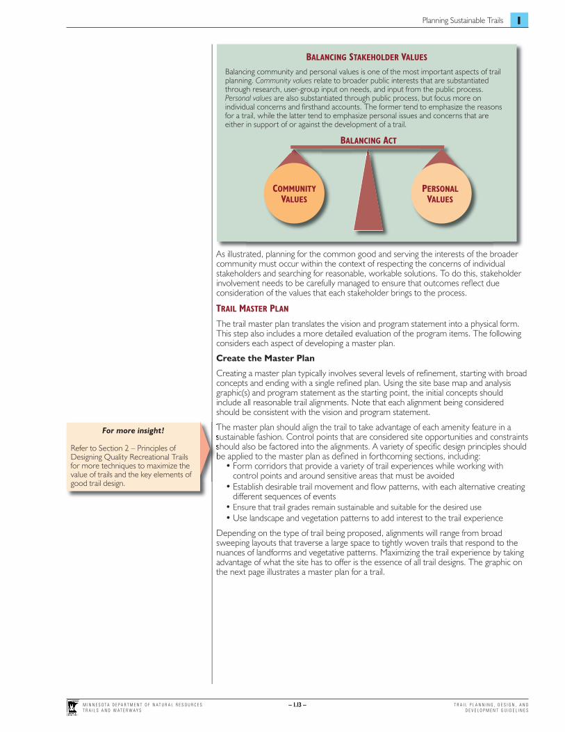
As illustrated, planning for the common good and serving the interests of the broader community must occur within the context of respecting the concerns of individual stakeholders and searching for reasonable, workable solutions. To do this, stakeholder involvement needs to be carefully managed to ensure that outcomes refl ect due consideration of the values that each stakeholder brings to the process.
TRAIL MASTER PLAN
The trail master plan translates the vision and program statement into a physical form. This step also includes a more detailed evaluation of the program items. The following considers each aspect of developing a master plan.
Create the Master Plan
Creating a master plan typically involves several levels of refi nement, starting with broad concepts and ending with a single refi ned plan. Using the site base map and analysis graphic(s) and program statement as the starting point, the initial concepts should include all reasonable trail alignments. Note that each alignment being considered should be consistent with the vision and program statement.
The master plan should align the trail to take advantage of each amenity feature in a sustainable fashion. Control points that are considered site opportunities and constraints should also be factored into the alignments. A variety of specifi c design principles should be applied to the master plan as defi ned in forthcoming sections, including:
• Form corridors that provide a variety of trail experiences while working with control points and around sensitive areas that must be avoided
• Establish desirable trail movement and fl ow patterns, with each alternative creating different sequences of events
• Ensure that trail grades remain sustainable and suitable for the desired use • Use landscape and vegetation patterns to add interest to the trail experience
Depending on the type of trail being proposed, alignments will range from broad sweeping layouts that traverse a large space to tightly woven trails that respond to the nuances of landforms and vegetative patterns. Maximizing the trail experience by taking advantage of what the site has to offer is the essence of all trail designs. The graphic on the next page illustrates a master plan for a trail.
BALANCING STAKEHOLDER VALUES
Balancing community and personal values is one of the most important aspects of trail planning. Community values relate to broader public interests that are substantiated through research, user-group input on needs, and input from the public process. Personal values are also substantiated through public process, but focus more on individual concerns and fi rsthand accounts. The former tend to emphasize the reasons for a trail, while the latter tend to emphasize personal issues and concerns that are either in support of or against the development of a trail.
COMMUNITY VALUES
PERSONAL VALUES
BALANCING ACT
For more insight!
Refer to Section 2 – Principles of Designing Quality Recreational Trails for more techniques to maximize the value of trails and the key elements of good trail design.
The master plan should align the trail to take advantage of each amenity feature in a sustainable fashion. Control points that are considered site opportunities and constraints should also be factored into the alignments. A variety of specifi c design principles should be applied to the master plan as defi ned in forthcoming sections, including:

M I N N E S O T A D E P A R T M E N T O F N A T U R A L R E S O U R C E ST R A I L S A N D W A T E R W A Y S
– 1.14 – T R A I L P L A N N I N G , D E S I G N , A N D D E V E L O P M E N T G U I D E L I N E S
– 1.14 –
MASTER PLAN EXAMPLE In graphic form, the master plan should illustrate the trail’s alignment and all physical nuances that affect its location. Photos and other supportive graphics can enhance stakeholders’ understanding of the proposed plan. This particular image is one section of a linear trail following a creek corridor in a conservation area in a suburban setting. A natural hiking trail is proposed in keeping with the setting. Buffers are also provided along the creek to minimize the likelihood of sediment migrating from the trail to the creek.
WESTERN SECTION (PART 1 OF 3 PARTS)

T R A I L P L A N N I N G , D E S I G N , A N D D E V E L O P M E N T G U I D E L I N E S
– 1.15 –
Planning Sustainable Trails 1
M I N N E S O T A D E P A R T M E N T O F N A T U R A L R E S O U R C E ST R A I L S A N D W A T E R W A Y S
– 1.15 –
DETAILED CONSIDERATIONS AT THE MASTER PLAN LEVEL
There are numerous detailed considerations that start at the master plan level and are refi ned through subsequent steps. It is especially important to identify and consider issues that directly impact the decision on the appropriateness of the trail for the intended uses and environmental review and permitting.
Permit Requirements
A detailed listing of all permits required for the trail project should be assembled based on the master plan. For local, county, and regional trails, local regulatory agencies should be contacted to determine permit requirements.
Ecological Sustainability
Once the preferred trail alignment is laid out, a critical review of site-specifi c ecological impacts should be undertaken. This typically includes review of the six principles of ecological sustainability as defi ned in Section 3 – Principles of Ecological Sustainability.
Physical Sustainability
A physically sustainable trail is one that can stand the test of time through years of use. The heavier the use and more susceptible the landscape, the more diligence is needed on the physical development of the trail. At the master plan level, factors affecting the physical sustainability of the trail should be identifi ed. This includes identifying potential:
• Trail alignments that balance desired experience with physical sustainability• Tread surfacing materials for each segment of the trail, taking into consideration
soils, slopes, drainage, vegetation patterns, and other infl uences• Locations for structures, including:
– Bridges– Boardwalks or other forms of traversing wetlands or sensitive areas– Underpasses, overpasses, and grade crossings– Stream crossings– Culverts – Retaining structures and railings or fencing
• Areas requiring extensive earthwork or engineering to establish the trail
Construction impacts should also be considered as part of evaluating the physical sustainability of the trail. This includes the impacts of heavy machinery on the site, the potential erosion during construction, temporary accesses, and noise. The collateral impacts of construction should also be considered, including impacts to:
• Sensitive areas• Wildlife (nesting, breeding, migration, etc.)• Exotic species and noxious weeds• Adjacent landowners (noise, dust, access)• Existing trails and roads used to access the trail during construction
Engendering Stewardship
Engendering stewardship is a hard-to-defi ne but important aspect of creating sustainable trails. Trails that are ecologically and physically sustainable are more likely than unsustainable trails to elicit a sense of stewardship in users because less effort is required of them.
Stewardship is also infl uenced by how well the trail meets users’ expectations. The higher the personal value the trail holds, the greater the likelihood the visitor will take responsibility for taking care of it.
STEP 2 – PUBLIC NOTIFICATION AND COMMENT Public notifi cation and comment is part of a formal process often legally required by administering and regulatory agencies to ensure that all interested parties have ample opportunity to respond to a trail proposal. This is part of the overall stakeholder input strategy defi ned under Step 1. For DNR projects, a 30-day comment period is a common requirement.
The public typically is notifi ed by e-mail, U.S. mail, press releases, paid advertisements, and/or website postings. Public meetings may also be scheduled as necessary.
Listing of regulatory agencies!
A listing of regulatory agencies and their area of jurisdiction is listed under Regulatory Framework earlier in this section.
Permit Requirements
A detailed listing of all permits required for the trail project should be assembled based on the master plan. For local, county, and regional trails, local regulatory agencies should be contacted to determine permit requirements.
Ecological Sustainability
For more specifi c design and development information!
Refer to Section 5 – Shared-Use Paved Trails and Section 6 – Sustainable Natural Surfaced Trails for guidelines on designing physically sustainable trails.
A physically sustainable trail is one that can stand the test of time through years of use. The heavier the use and more susceptible the landscape, the more diligence is needed on the physical development of the trail. At the master plan level, factors affecting the physical sustainability of the trail should be identifi ed. This includes identifying potential:
For more information!
Refer to Grant Program Considerations earlier in this section to determine the specifi c public notifi cation and comment requirements related to particular grant program.
Public notifi cation and comment is part of a formal process often legally required by administering and regulatory agencies to ensure that all interested parties have ample opportunity to respond to a trail proposal. This is part of the overall stakeholder input strategy defi ned under Step 1. For DNR projects, a 30-day comment period is a common requirement.

M I N N E S O T A D E P A R T M E N T O F N A T U R A L R E S O U R C E ST R A I L S A N D W A T E R W A Y S
– 1.16 – T R A I L P L A N N I N G , D E S I G N , A N D D E V E L O P M E N T G U I D E L I N E S
– 1.16 –
STEP 3 – ENVIRONMENTAL REVIEW Environmental review is fundamental to sustainable trail planning to minimize impacts to sensitive ecological systems. For some projects, a formal environmental review may also be required. Refer to the Minnesota Environmental Review Rules (Minnesota Rules Chapter 4410) at the EQB’s website (www.eqb.state.mn.us) for regulatory requirements that may relate to trails. Note that trail projects requiring a formal environmental review cannot be implemented until the review is complete.
Determining the level of environmental review that is necessary for a given trail project is typically the responsibility of the RGU. For DNR Division of Trails and Waterways projects, the Environmental Policy and Review Unit in the Division of Ecological Services would perform the RGU responsibilities. If the review process identifi es potential signifi cant environmental effects, modifi cations to the project or mitigation of impacts will likely be required.
STEP 4 – TRAIL DESIGN AND CONSTRUCTION DOCUMENTS Once the major planning and environmental review is completed, detailed design and construction document preparation is undertaken. This includes the application of specifi c design standards that will ensure the health, safety, and wellness of the public. It also includes the application of best practices to ensure long-term sustainability and protect the surrounding environment.
The guidelines presented in this manual provide the basis for trail design for most types of trails. These guidelines should be complemented with other established standards to ensure the highest quality design and engineering. For state and federal funded projects, very specifi c design and engineering requirements are mandated. Adhering to these requirements for a given trail project is typically the responsibility of the RGU, in cooperation with state or federal agencies responsible for administering state or federal grants.
STEP 5 – PROJECT PERMITTING Virtually all trail projects will require permits as part of the approval process. Most of these relate to protecting Minnesota waters and wetlands. Submittal and approval of all permit applications is required prior to any construction. Typically, the RGU provides assistance in determining permit requirements. However, proposers of trail projects should be familiar with the various permitting agencies and jurisdictions to ensure that all requirements are met prior to any trail development.
In addition to regulatory permits, land-use approvals from landowners or land managers (public and private) should be obtained. Road right-of-way use and site access approvals from appropriate state, county, or local highway authority may also be necessary.
STEP 6 – MANAGEMENT, MONITORING, AND STEWARDSHIP Once a trail is developed, appropriate management, monitoring, and stewardship (maintenance) are all necessary to ensure its long-term sustainability. Trail management defi nes operational procedures, marketing approaches, rules, and enforcement levels to ensure the trail serves the targeted user group(s) and is properly used. More intensive and/or specialized uses require higher levels of management.
Trail stewardship relates to the routine preventive maintenance of the trail and stewardship of adjoining natural areas. The higher the classifi cation and more intensive the use, the more maintenance required to ensure sustainability.
A specifi c management, monitoring, and stewardship plan should be prepared and implemented as part of a trail’s development. Other sections of this manual provide guidelines on each of these issues as related to specifi c types of trails.
Listing of regulatory agencies!
A listing of regulatory agencies and their area of jurisdiction can be found under Regulatory Framework earlier in this section.
STEP 3 – ENVIRONMENTAL REVIEW Environmental review is fundamental to sustainable trail planning to minimize impacts to sensitive ecological systems. For some projects, a formal environmental review may also be required. Refer to the Minnesota Environmental Review Rules (Minnesota Rules Chapter 4410) at the EQB’s website (www.eqb.state.mn.us) for regulatory requirements that may relate to trails. Note that trail projects requiring a formal
Sound ecological planning is the essence of sustainable trails!
Section 3 – Principles of Ecological Sustainability provides sound advice on planning trails in natural areas. If these principles are applied, the design of a trail is likely to be very consistent with standard regulatory requirements.
environmental review cannot be implemented until the review is complete.
Determining the level of environmental review that is necessary for a given trail project is typically the responsibility of the RGU. For DNR Division of Trails and Waterways projects, the Environmental Policy and Review Unit in the Division of Ecological Services would perform the RGU responsibilities. If the review process identifi es potential signifi cant environmental effects, modifi cations to the project or mitigation of impacts will likely be required.
For more specifi c design and development information!
Refer to Section 5 – Shared-Use Paved Trails, Section 6 – Sustainable Natural Surfaced Trails, and Section 7 – Winter Use Trails for guidelines on design and construction of various types of trails.
protect the surrounding environment.
The guidelines presented in this manual provide the basis for trail design for most types of trails. These guidelines should be complemented with other established standards to ensure the highest quality design and engineering. For state and federal funded projects, very specifi c design and engineering requirements are mandated. Adhering to these requirements for a given trail project is typically the responsibility of the RGU, in