1. study design and system goals - dot.sd.gov
TRANSCRIPT

1-1
1. Study Design and System Goals 1.1. Introduction The South Dakota State Aviation System Plan (SDSASP) is an important tool used by the South Dakota Department of Transportation Office of Aeronautics Services (SDDOT), the Federal Aviation Administration (FAA), airport sponsors, and other aviation stakeholders to: (1) maintain critical aviation infrastructure and services and (2) plan for future needs and response to anticipated industry changes. The most recent SDSASP was published in 2010 and it was the first aviation system plan developed for the state. Since that time, the aviation industry has continued to evolve, bringing about changes in operations, technology, regulatory and advisory resources. To address these advancements and enhance the ways the system plan information can be used by SDDOT and aviation stakeholders, the SDDOT embarked on the 2020 SDSASP which provides a new flight plan for the preservation and future development of South Dakota’s aviation assets over the next 20 years. The primary purpose of the 2020 SDSASP is to study and assess the condition, performance, interaction, and needs of system airports. This document is intended to guide decisions and educate those who oversee the system, including local, state and federal policy makers, the South Dakota Aeronautics Commission (SDAC) and SDDOT staff. As was conducted in the previous system plan, the 2020 SDSASP includes an Aviation Economic Impact Study (AEIS) which documents both the quantitative and qualitative value of South Dakota’s aviation system at the local, regional, and statewide levels for residents, businesses, and visitors to the Mount Rushmore State. This chapter provides an overview of the purpose of state aviation system planning, the composition of South Dakota’s aviation system, the process followed to develop the 2020 SDSASP, the methods in which stakeholder input was incorporated, and the goals and performance measures that were collectively chosen to define the SDSASP.
1.2. Purpose of Airport System Planning Like other modal transportation plans (such as a long-range statewide transportation plan or a freight plan) aviation system plans identify how the aviation network will meet stakeholder goals and user needs within the applicable regulatory and economic framework over an extended period of time.
As noted in FAA Advisory Circular (AC) 150/5070-7, Change 1, The Airport System Planning Process, airport or aviation system planning helps aviation agencies determine the “type, extent, location, timing, and cost of airport development needed…to establish a viable system of airports.” The practice of aviation planning takes place at the federal, state, and airport levels, each informing the other as shown in Figure 1-1.
At the local level, airport master plans provide detailed, long-term development plans and financial implementation schedules for infrastructure and service enhancement for a specific airport facility. State aviation system plans consider the findings of individual master plans and other statewide needs in the creation of a coordinated statewide plan for development that meets state goals and federal requirements. System planning is conducted at the federal level by the FAA through the National Plan of Integrated Airport Systems (NPIAS) which identifies over 3,300 airports in the US that are important to

1-2
national air transportation. This national comprehensive planning effort uses findings from state system planning and individual airport master plans to understand the improvements needed to develop and maintain a safe and secure National Airspace System (NAS), supporting the FAA’s strategic goals for safety, system efficiency, and environmental compatibility.
Figure 1-1: Aviation System Planning at the Federal, State, and Local Levels
Source: Kimley-Horn, 2020 Airports, states, and the FAA use system planning results to guide decision-making and responsibly apply resources to develop a network of airports consistent with existing and future needs. This process is primarily achieved by coordinating the NPIAS with the Airports Capital Improvement Program (ACIP), which applies a systematic process for identifying, prioritizing, and assigning federal aviation funds to those projects most critical for the NAS. The FAA requires states to conduct system planning to obtain federal funding through the Airport Improvement Program (AIP) for airports included in the NPIAS.
1.3. System Airports Fifty-six airports are included in the 2020 SDSASP analysis as determined by SDDOT (listed in Table 1-1). These 56 airports were selected for inclusion due to their public ownership, public-use availability, and inclusion within the NPIAS. As discussed previously, the NPIAS identifies airports that are critical to the national air transportation network; not all public-use or publicly-owned airports in the US are included in the NPIAS. The distinction between airports included in the NPIAS and those that are not is eligibility for federal funding from the FAA through the AIP. Military bases are also excluded from the NPIAS as the U.S. Department of Defense (DoD) is responsible for the development and planning for those facilities. As such, facilities like Ellsworth Air Force Base near Rapid City are not included in the SDSASP.
In the latest NPIAS report (2019-2023), 58 airports in the state are included. However, Kadoka and Presho are not currently meeting the minimum FAA criteria for inclusion in the NPIAS, they are not

1-3
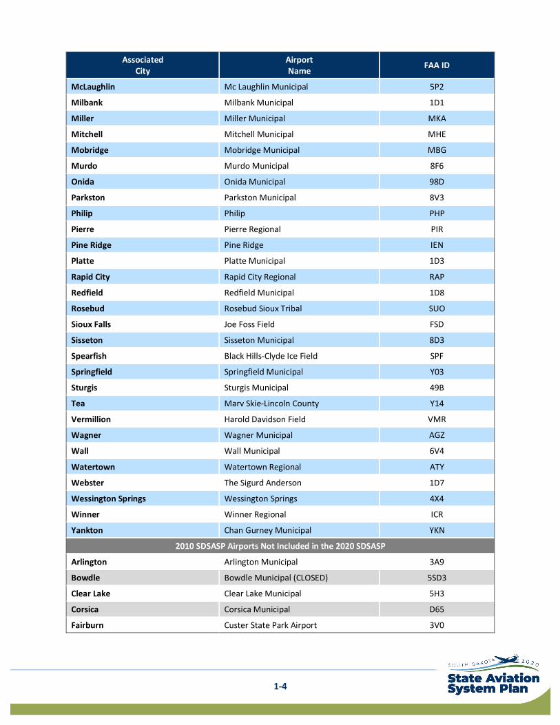
federally obligated having not received federal AIP grants in the past several years, have expressed interest in leaving the NPIAS, and have limited activity. As such, Presho and Kadoka are not included in the 2020 SDSASP. Chapter 3. Airport Roles includes a detailed look at the current composition of South Dakota’s NPIAS airports, and recommendations for NPIAS inclusion and exclusion moving forward. The 2010 SDSASP included 72 public-use airports in South Dakota (including NPIAS and non-NPIAS airports). While the non-NPIAS airports were removed from the 2020 SDSASP, they are still open for public use. Table 1-1 also lists the 14 airports that were previously included in the 2010 SDSASP that are not included in the 2020 SDSASP.
Table 1-1: 2020 SDSASP Airports Associated
City Airport Name FAA ID
Aberdeen Aberdeen Regional ABR
Belle Fourche Belle Fourche Municipal EFC
Bison Bison Municipal 6V5
Britton Britton Municipal BTN
Brookings Brookings Regional BKX
Buffalo Harding County 9D2
Canton Canton Municipal 7G9
Chamberlain Chamberlain Municipal 9V9
Clark Clark County 8D7
Custer Custer County CUT
De Smet Wilder 6E5
Eagle Butte Cheyenne Eagle Butte 84D
Edgemont Edgemont Municipal 6V0
Eureka Eureka Municipal 3W8
Faith Faith Municipal D07
Faulkton Faulkton Municipal 3FU
Flandreau Flandreau Municipal 4P3
Gettysburg Gettysburg Municipal 0D8
Gregory Gregory Municipal-Flynn Field 9D1
Highmore Highmore Municipal 9D0
Hot Springs Hot Springs Municipal HSR
Hoven Hoven Municipal 9F8
Howard Howard Municipal 8D9
Huron Huron Regional HON
Lemmon Lemmon Municipal LEM
Madison Madison Municipal MDS
Martin Martin Municipal 9V6
1-4
Associated City
Airport Name FAA ID
McLaughlin Mc Laughlin Municipal 5P2
Milbank Milbank Municipal 1D1
Miller Miller Municipal MKA
Mitchell Mitchell Municipal MHE
Mobridge Mobridge Municipal MBG
Murdo Murdo Municipal 8F6
Onida Onida Municipal 98D
Parkston Parkston Municipal 8V3
Philip Philip PHP
Pierre Pierre Regional PIR
Pine Ridge Pine Ridge IEN
Platte Platte Municipal 1D3
Rapid City Rapid City Regional RAP
Redfield Redfield Municipal 1D8
Rosebud Rosebud Sioux Tribal SUO
Sioux Falls Joe Foss Field FSD
Sisseton Sisseton Municipal 8D3
Spearfish Black Hills-Clyde Ice Field SPF
Springfield Springfield Municipal Y03
Sturgis Sturgis Municipal 49B
Tea Marv Skie-Lincoln County Y14
Vermillion Harold Davidson Field VMR
Wagner Wagner Municipal AGZ
Wall Wall Municipal 6V4
Watertown Watertown Regional ATY
Webster The Sigurd Anderson 1D7
Wessington Springs Wessington Springs 4X4
Winner Winner Regional ICR
Yankton Chan Gurney Municipal YKN
2010 SDSASP Airports Not Included in the 2020 SDSASP
Arlington Arlington Municipal 3A9
Bowdle Bowdle Municipal (CLOSED) 5SD3
Clear Lake Clear Lake Municipal 5H3
Corsica Corsica Municipal D65
Fairburn Custer State Park Airport 3V0

1-5
Associated City
Airport Name FAA ID
Herreid Herreid Municipal 5T4
Isabel Isabel Municipal 3Y7
Kadoka Kadoka Municipal 5V8
Kimball Kimball Municipal 6A6
Lake Andes Lake Andes Municipal 8D8
Lake Preston Lake Preston Municipal (CLOSED) Y34
McIntosh McIntosh Municipal (CLOSED) 8D6
North Sioux City Graham Field Airport (Privately Owned) 7K7
Presho Presho Municipal 5P5
Timber Lake Timber Lake Municipal D58
White River White River Municipal 7Q7 Source: Kimley-Horn, 2020
1.4. Study Process As previously noted, the 2020 SDSASP includes two separate, but related studies. The processes for completing both the SDSASP and the AEIS are detailed in the following sections. While each study process is shown separately, these two studies were conducted concurrently to form the 2020 SDSASP.
1.4.1. South Dakota State Aviation System Plan (SDSASP) The FAA’s AC 150/5070-7, Change 1, The Airport System Planning Process, provides the foundation for developing a system plan in a coordinated manner, which is critical as several of the tasks in the process are interrelated, as shown in Figure 1-2. The latest update of the AC calls for additional analyses beyond what has traditionally been included in a system plan, including evaluating airport needs relative to multimodal planning, and considering environmental conditions as a part of system plans. Each of these additional analyses were included in the development of the 2020 SDSASP as shown in the figure.
Key to developing a system plan that is useful and meaningful to aviation stakeholders in South Dakota is to engage the public in the creation of the plan. As depicted in Figure 1-2, the SDDOT solicited public input throughout the entire system planning process using a project website, a Project Advisory Committee (PAC), presentations at annual aviation conferences, and more. A summary of PAC involvement is provided in Section 1.5. Project Advisory Committee (PAC).

1-6
Figure 1-2: SDSASP Process
Source: Kimley-Horn, 2020
1.4.2. Aviation Economic Impact Study (AEIS) The AEIS evaluates the direct and indirect impact of South Dakota’s aviation system on the local, regional and statewide levels. Economic impacts were quantified for each of the 56 study airports and for the system as a whole. The AEIS results are used to communicate the quantitative and qualitative benefits of the state’s airports and validate the continued public investment in South Dakota’s airport system.
The AEIS was conducted concurrently with the SDSASP update but had its own unique process as outlined in Figure 1-3. Unlike the SDSASP, there is no federal guidance or regulations outlining the steps required to conduct an AEIS.
Figure 1-3: AEIS Process
Source: Kimley-Horn, 2020

1-7
1.5. Project Advisory Committee (PAC) Including public involvement in the system planning process is incredibly important. A dynamic stakeholder engagement process is essential to the development of analyses and deliverables that reflect and address the considerations of those who use and depend on air transportation in South Dakota. This effort provides consensus and assists SDDOT with the implementation of final study recommendations.
A key component of the public involvement process includes the formation of an advisory committee. As shown in Figure 1-4, a Project Advisory Committee (PAC) was assembled by SDDOT at the beginning of the 2020 SDSASP to provide local and regional insight on issues impacting their use and operation at system airports along with issues impacting aviation across the state. The PAC was comprised of diverse stakeholders with a broad range of industry knowledge and experience in airports, aviation, and other related fields (such as public health, economic development, and more). The following list includes the entities represented on the PAC roster:
• Federal and State agencies (FAA, SDDOT, Governor’s Office of Economic Development, South Dakota Department of Health)
• South Dakota Aeronautics Commission • Airports, including general aviation (GA) and commercial service facilities • Medical operators (Sanford Health and Avera Health) • Aviation associations (SD Aviation Association, SD Airport Managers Association, and SD Pilots
Association)
These members were consulted and engaged at every stage of the study process to solicit feedback on the usefulness and effectiveness of the study tasks.
Figure 1-4: 2020 SDSASP PAC Composition
Source: Kimley-Horn, 2020
1.6. Goal and Performance Measure Considerations Core to developing a system plan is establishing goals and measurable actions to achieve those goals; this is the first step in system plan development. These goals determine how measurement of the system’s performance is conducted and ultimately the recommendations that result when a system plan is completed (which are then incorporated at the federal-level in the NPIAS, where appropriate).
To help guide the development of the 2020 SDSASP goals, a review of the existing resources including the 2010 SDSASP and other SDDOT transportation studies was conducted. Additionally, feedback and suggestions for system goals were provided by members of the PAC who represent South Dakota’s numerous aviation system stakeholders.

1-8
After reviewing the 2010 SDSASP goals and other South Dakota transportation plans for potential alignment, SDDOT proposed and the PAC confirmed carrying forward the goals that were established in the 2010 SDSASP:
• Safety and Security • Maintenance and Development of Infrastructure • Accessibility to Users
The 2010 plan listed three “objectives” or methods to achieve each goal. These nine total objectives were broad and overarching in their method to achieve each goal. To more clearly define how the 2020 system is measured and to set transparent, attainable targets, SDDOT and the PAC reviewed several potential measures related to each of the three goals. Some of these measures were carried forward from 2010 but were more clearly defined, and others were completely new. The idea was to select measures that allow for a better determination of the health and adequacy of the system as well as those that could be frequently tracked and updated. Through the selection and refinement of measures, it was understood that some of the measures could be influenced by SDDOT action (either policy or funding) and others could not. The measures that SDDOT could not impact were identified as “Performance Indicators,” or PIs, rather than “Performance Measures,” or PMs.
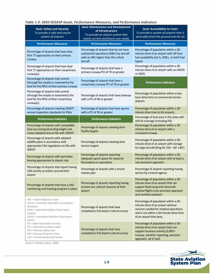
1.7. System Goals, Performance Measures, and Performance Indicators After extensive review and consideration of existing resources and input from the PAC, the goals and corresponding PMs and PIs shown in Table 1-2 were chosen for the 2020 SDSASP. A discussion of each goal is provided following the table.
1-9
Table 1-2: 2020 SDSASP Goals, Performance Measures, and Performance Indicators
Goal: Safety and Security To provide a safe and secure
system of airports
Goal: Maintenance and Development of Infrastructure
To provide an airport system that meets current and future user needs
Goal: Accessibility to Users To provide a system of airports that is accessible from the ground and the air
Performance Measures Performance Measures Performance Measures
Percentage of airports that have clear Part 77 approaches on their primary runway
Percentage of airports that do not have substantial operations (500+) by aircraft with an ARC higher than the critical aircraft
Percentage of population within a 30-minute drive of an airport with 24-hour fuel availability (Jet A, 100LL, or both fuel types)
Percentage of airports that have clear Part 77 approaches on their nonprimary runway(s)
Percentage of airports that have a primary runway PCI of 70 or greater
Percentage of population within a 30-minute drive of an airport with an AWOS or ASOS
Percentage of airports that control (through fee simple or easements) the land for the RPZs of their primary runway
Percentage of airports that have a nonprimary runway PCI of 70 or greater Performance Indicators
Percentage of airports that control (through fee simple or easements) the land for the RPZs of their nonprimary runway(s)
Percentage of airports that have taxiways with a PCI of 60 or greater
Percentage of population within a two-hour drive time to commercial service airports
Percentage of airports meeting SDDOT annual inspection standards for RSAs
Percentage of airports that have aprons with a PCI of 50 or greater
Percentage of population within a 30-minute drive time to GA airports
Performance Indicators Performance Indicators Percentage of land area in the state with ADS-B coverage (including FIS)
Percentage of airports with compatible land use zoning (including height and noise) adopted and on file with SDDOT
Percentage of airports meeting their facility targets
Percentage of population within a 30-minute drive of an airport with a crosswind runway
Percentage of airports with adopted wildlife plans in accordance with appropriate FAA regulations on file with SDDOT
Percentage of airports meeting their service targets
Percentage of population within a 30-minute drive of an airport with storage for large aircraft (King Air 250 – 60’ x 80’)
Percentage of airports with perimeter fencing appropriate to airport role
Percentage of airports reporting adequate apron space for seasonal fluctuations in operations
Percentage of population within a 30-minute drive of an airport with at least a non-precision approach
Percentage of airports that report having UAS activity at and/or around their airport
Percentage of airports with a recent master plan
Percentage of airports reporting having service by a transit agency
Percentage of airports that have a UAS monitoring and tracking program in place
Percentage of airports reporting having at least one cultural resource at their airport
Percentage of population within a 30-minute drive of an airport that can support fixed-wing and rotorcraft medical flights (non-precision approach and certified weather)
ARC = Airport Reference Code ADS-B = Automatic Dependent Surveillance – Broadcast ASOS = Automated Surface Observation Systems AWOS = Automated Weather Observation System FIS = Flight Information Services PCI = Pavement Condition Index RSA = Runway Safety Area RPZ = Runway Protection Zone UAS = Unmanned Aircraft System
Percentage of airports that have completed a full airport cultural survey
Percentage of population within a 30-minute drive of an airport without services needed for medical operations and is not within a 30-minute drive time of an airport that does.
Percentage of airports that have completed a full airport cultural survey
Percentage of population within a 30-minute drive of an airport that can support business activity (5,000’+ runway, weather reporting, precision approach, Jet A fuel).
Source: Kimley-Horn, 2020

1-10
1.7.1. Goal: Safety and Security The intention of this goal is to provide a safe and secure system of airports. This is achieved in part through maintaining clear approaches to runways, ownership or control of land within critical safety areas at and around airports, and protection against outside elements such as incompatible land uses and wildlife.
To evaluate the adequacy of South Dakota’s airport system in achieving a safe and secure system of airports, the following PMs and PIs are used:
1.7.1.1. Performance Measures • Percentage of airports that have clear Part 77 approaches on their primary runway • Percentage of airports that have clear Part 77 approaches on their nonprimary runway(s) • Percentage of airports that control (through fee simple or easements) the land for the RPZs of
their primary runway • Percentage of airports that control (through fee simple or easements) the land for the RPZs of
their nonprimary runway(s) • Percentage of airports meeting SDDOT annual inspection standards for RSAs
1.7.1.2. Performance Indicators • Percentage of airports with compatible land use zoning (including height and noise) adopted
and on file with SDDOT • Percentage of airports with adopted wildlife plans in accordance with appropriate FAA
regulations on file with SDDOT • Percentage of airports with perimeter fencing appropriate to airport role • Percentage of airports that report having UAS activity at and/or around their airport • Percentage of airports that have a UAS monitoring and tracking program in place
1.7.2. Goal: Maintenance and Development of Infrastructure The intention of this goal is to provide an airport system that meets current and future user needs. Significant investment has been made in South Dakota’s airport system and preserving this investment is critically important to the system’s long-term viability. One of the most significant investments in an airport is the pavements that comprise the airfield including runways, taxiways, and aprons. Preserving these pavements, improving infrastructure, and proactive airport planning are vital to ensuring that the system can meet facility and service targets and future demand.
To evaluate the adequacy of South Dakota’s airport system in meeting current and future user needs, the following PMs and PIs are used:
1.7.2.1. Performance Measures • Percentage of airports that do not have substantial operations (500+) by aircraft with an ARC
higher than the critical aircraft. • Percentage of airports that have a primary runway PCI of 70 or greater • Percentage of airports that have a nonprimary runway PCI of 70 or greater • Percentage of airports that have taxiways with a PCI of 60 or greater • Percentage of airports that have aprons with a PCI of 50 or greater

1-11
1.7.2.2. Performance Indicators • Percentage of airports meeting their facility targets • Percentage of airports meeting their service targets • Percentage of airports reporting adequate apron space for seasonal fluctuations in operations • Percentage of airports with a recent master plan • Percentage of airports reporting having at least one cultural resource at their airport • Percentage of airports that have completed a full airport cultural survey
1.7.3. Goal: Accessibility to Users The intention of this goal is to provide a system of airports that is accessible from the ground and the air. Certain types of infrastructure and services are vital to the operation of key aviation activities in the state, such as medical transportation and business operations. Providing reasonable access from the ground and the air to airports with the needed facilities and services (such as fuel and weather reporting) supports the continued operation of these key activities. Allowing for reasonable drive times to both commercial service and GA airports provides South Dakotan’s and visitors access to the national air transportation network.
To evaluate the adequacy of South Dakota’s airport system in providing reasonable ground and air access to users, the following are used:
1.7.3.1. Performance Measures • Percentage of population within a 30-minute drive of an airport with 24-hour fuel availability
(Jet A, 100LL, or both fuel types) • Percentage of population within a 30-minute drive of an airport with an Automated Weather
Observing System (AWOS) or Automated Surface Observing System (ASOS)
1.7.3.2. Performance Indicators • Percentage of population with a two-hour drive time to commercial service airports • Percentage of population within a 30-minute drive time to GA airports • Percentage of land area in the state with Automatic Dependent Surveillance-Broadcast (ADS-B)
coverage including Flight Information Services (FIS) • Percentage of population within a 30-minute drive of an airport with a crosswind runway • Percentage of population within a 30-minute drive of an airport with storage for large aircraft
(King Air 250, 60’ x 80’) • Percentage of population within a 30-minute drive of an airport with at least a non-precision
approach • Percentage of airports reporting having service by a transit agency • Percentage of population within a 30-minute drive of an airport that can support fixed-wing and
rotorcraft medical flights • Percentage of population within a 30-minute drive of an airport without services needed for
medical operations (approach and AWOS/ASOS) and is not within a 30-minute drive time of an airport that does.
• Percentage of population within a 30-minute drive of an airport that can support business activity

1-12
1.8. Summary Using the guidance provided by AC 150/5070-7, Change 1, and input from SDDOT and the PAC membership, the 2020 SDSASP builds on the success of the 2010 plan and sets the stage for South Dakota’s aviation system development over the next 20 years. The goals, PMs and PIs presented in this chapter form the foundation of the 2020 study. All subsequent tasks are based upon the direction provided by these measures. Specifically, these measures and indicators are used to inventory system condition, calculate performance, identify successes and shortfalls, develop recommendations, and prioritize system needs, all of which are presented in later chapters.