1. introduction · availability (sa) by former u.s. president, bill clinton, ionospheric effect is...
TRANSCRIPT

GPS Amplitude Scintillation Monitoring at Equatorial Region Using GPStation-6
Y.H Ho
Faculty of Electronic & Computer Engineering, Universiti Teknikal Malaysia Melaka, Hang Tuah Jaya, 76100
Durian Tunggal, Melaka, Malaysia. E-mail: [email protected]
Abstract
As technology advancement progresses throughout the years in this modern age, every technology has its part to
play in that the world is moving towards a brighter future. GPS (Global Positioning System) has diverse application in current globalized world, its application has pervasive benefits not only to navigation and positioning, it is pivotal in industries like logistics, shipping, financial services and agriculture. Since the decision to shut down the Selectivity Availability (SA) by former U.S. President, Bill Clinton, ionospheric effect is now the primary concern of error contributing factors in GPS. Ionospheric scintillation induces rapid fluctuations in the phase and the amplitude of received GNSS signals. These rapid fluctuations or scintillation potentially introduce cycle slips, degrade range measurements, and if severe enough lead to loss of lock in phase and code. A GPS Ionospheric Scintillation and TEC Monitor (GISTM) receiver, GPStation-6, has been installed at Melaka, Malaysia (2.31° N, 102.32° E) to study the ionospheric variability at a low-latitude location. The GPS receiver was recording the scintillation indices for both L1 and L2C GPS signals. This paper presenting the preliminary results for the data collected and analyzed for the period of 3 months with sample of every 60 seconds for 24 hours daily. The scintillation amplitude, the elevation angle and availability of GPS satellites were reported.
1. Introduction
Space weather can be defined as changes in conditions of sun’s ambient plasma, magnetic fields, radiation and in
the solar wind that affects the earth’s magnetosphere, ionosphere, and thermosphere. It can influence the performance and reliability of space-borne and ground-based technological systems [1]. Adverse conditions in this environment can cause disruption of satellite operations, communications, navigation, and electric power distribution grids, leading to a variety of socioeconomic losses [2].
GPS signal can be defined as electromagnetic wave generated by an oscillating energy from GPS satellites. Many
factors affect the signal quality as the signal strength decreases as the distance between the satellites and GPS receiver increases. This is essentially due to attenuation caused by geometric spreading and the attenuation in the troposphere and ionosphere layers.
Unlike the troposphere, the ionosphere is a dispersive medium extending between 50 km and 1000 km above the
earth’s surface. It is highly concentrated with electrically charged atoms or molecules (ions) that are formed primarily by solar radiation ionization. Ionospheric irregularities where the electron density can differ significantly from the ambient plasma cause both refraction and diffraction of radio signals [3]. The largest effect is on the speed of the signal, and hence the ionosphere mainly affects the measured pseudorange. The magnitude of the refraction is a function of the refractive index of the ionosphere in the path of the GNSS signal.
The sun entering a period of increased activity approximately every eleven years called solar maximum which
influences the amount of irradiance received from the Sun on earth. In 2013, it is expected that the sun activities reach to its maximum period, so this paper analyzes the maximum GPS scintillation in an important period.
The ionospheric scintillation can be defined as the rapid fluctuation of the amplitude and phase of the satellite
radio signals when they propagate through the ionosphere due to electron density irregularities. The amplitude scintillation generally being dominant at low latitudes or equatorial region, and the phase scintillation at high latitudes or polar region. GPS receiver operation can be severely impeded by diffraction or scattering via amplitude and phase scintillation. The received signal quality (i.e. carrier-to-noise density ratio) in a GPS receiver is directly impacted by amplitude scintillation and subsequently degrades both pseudorange and carrier phase measurements [4]. It can be sufficiently severe to cause signal fades as large as 30 dB and thereby forcing loss of lock. Phase scintillation can easily stress phase-lock loops (PLL) in GPS receivers resulting in a loss of phase lock and thus impeding carrier phase measurements.
Equatorial ionosphere is a region consisting of two ionization belts located approximately ( 15° ) of the
magnetic equator where scintillation activities at the maximum. Genarally, the ionospheric scintillation events in
978-1-4673-5225-3/14/$31.00 ©2014 IEEE
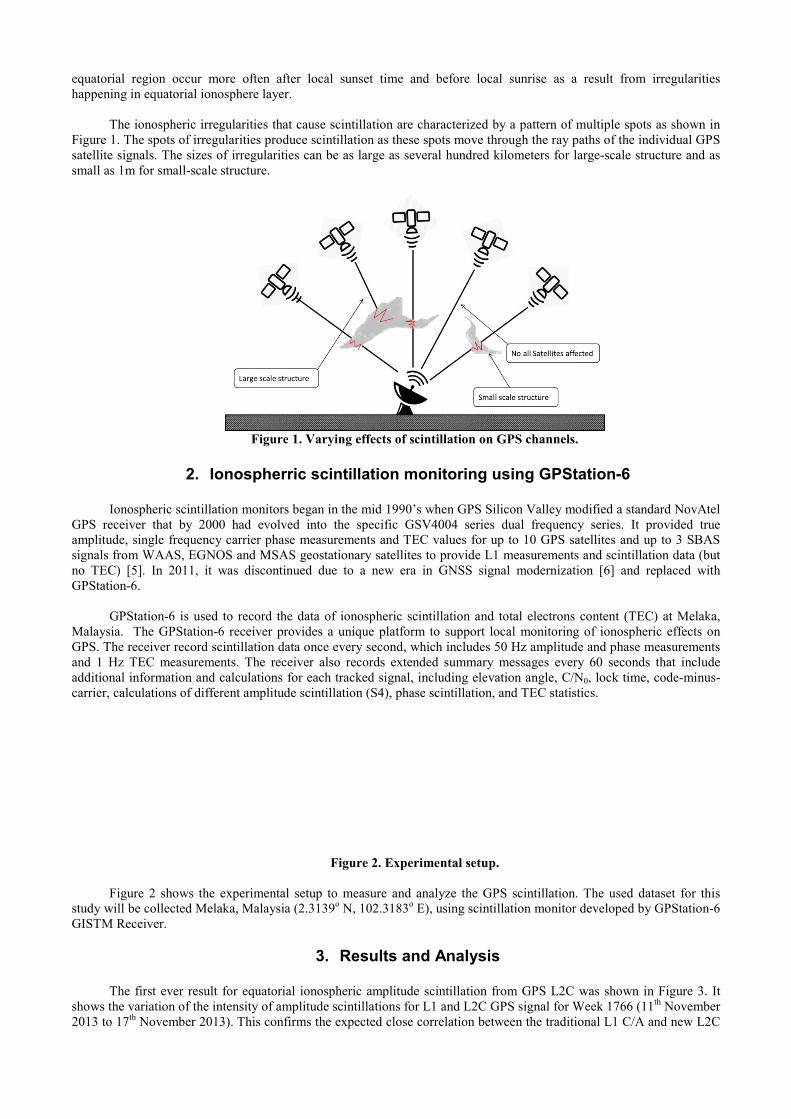
equatorial region occur more often afhappening in equatorial ionosphere layer
The ionospheric irregularities tha
Figure 1. The spots of irregularities prodsatellite signals. The sizes of irregularitismall as 1m for small-scale structure.
Figure
2. Ionospher
Ionospheric scintillation monitorsGPS receiver that by 2000 had evolvamplitude, single frequency carrier phassignals from WAAS, EGNOS and MSAno TEC) [5]. In 2011, it was discontiGPStation-6.
GPStation-6 is used to record th
Malaysia. The GPStation-6 receiver prGPS. The receiver record scintillation daand 1 Hz TEC measurements. The recadditional information and calculations carrier, calculations of different amplitud
Figure 2 shows the experimental
study will be collected Melaka, MalaysiaGISTM Receiver.
The first ever result for equatoria
shows the variation of the intensity of am2013 to 17th November 2013). This conf
fter local sunset time and before local sunrise as ar.
at cause scintillation are characterized by a pattern of duce scintillation as these spots move through the ray pies can be as large as several hundred kilometers for
e 1. Varying effects of scintillation on GPS channels
rric scintillation monitoring using GPS
s began in the mid 1990’s when GPS Silicon Valley mved into the specific GSV4004 series dual frequencse measurements and TEC values for up to 10 GPS s
AS geostationary satellites to provide L1 measurementnued due to a new era in GNSS signal moderniza
he data of ionospheric scintillation and total electronsrovides a unique platform to support local monitorinata once every second, which includes 50 Hz amplitud
ceiver also records extended summary messages evefor each tracked signal, including elevation angle, C/
de scintillation (S4), phase scintillation, and TEC statis
Figure 2. Experimental setup.
l setup to measure and analyze the GPS scintillationa (2.3139o N, 102.3183o E), using scintillation monitor
3. Results and Analysis
al ionospheric amplitude scintillation from GPS L2Cmplitude scintillations for L1 and L2C GPS signal for firms the expected close correlation between the tradit
a result from irregularities
f multiple spots as shown in paths of the individual GPS large-scale structure and as
s.
tation-6
modified a standard NovAtel cy series. It provided true satellites and up to 3 SBAS ts and scintillation data (but tion [6] and replaced with
s content (TEC) at Melaka, ng of ionospheric effects on de and phase measurements
ery 60 seconds that include /N0, lock time, code-minus-stics.
n. The used dataset for this r developed by GPStation-6
C was shown in Figure 3. It Week 1766 (11th November tional L1 C/A and new L2C

measurements. However, the overall S4 values for L1 signal are always higher than L2C signal. It is due to these new signals are stronger so should have lower noise in periods of high ionospheric activity.
Figure 3. Variation of the intensity of amplitude scintillations for L1 and L2C GPS signal for Week 1766
The GPS amplitude scintillation index S4 has been calculated from the collected data and analyzed at different
range of the elevation angles (Elv > 30o and Elv < 30o) for the both L1 and L2C signals considering all the available GPS satellites. Figure 4 shows the daily diurnal amplitude scintillation index variations for GPS pseudo random numbers (PRNs) (only those who are visible on that particular day) for October, November, and December 2013. The S4 index for L1 signal is presented by green curve, while the red curve represents L2C signal. Each plot shows the S4 index for the corresponding month versus the universe time (UT) for the two cases (Elv > 30o and Elv < 30o ) as shown in Figure 3 (a) and (b) respectively. It is clear that, many values of S4 index greater than 0.4 arise obviously when the Elv < 30o, where satellites with low elevation angles suffer large fluctuations due to multipath effects. In addition, it is confirm that S4 values for L1 signal are always higher than L2C signal. Interestingly all the indices show that amplitude scintillation are not always correlated over this time.
Figure 4. GPS S4 observations at UTeM, Malaysia for 3 months 2013 with elevation angle (a) Elv > 30o, (b)
Elv < 30o.
There are 32 GPS satellites available around the earth (PRN 01 - 32), but it is not all available for one region on the surface of the earth. Figure 6 (a) and (b) show the availability bars of GPS satellites for one day at November 2013 as example, for the dual frequency L1 and L2 respectively. It is very clear that the total number of available satellites for L1 GPS is more than its for L2 GPS.

Figure 6 Availability of GPS satellites at (a) L1 frequency, (b) L2 frequency.
4. Conclusion
Ionospheric scintillation has been experimentally investigated using GPStation-6 at Melaka, Malaysia station for
the dual frequency L1 and L2 at three months October, November, December 2013. The preliminary results confirm correlation between the traditional L1 C/A and new L2C measurements of amplitude scintillation. It is also reported that S4 values for L1 signal are always higher than L2C signal. It is due to these new signals are stronger so should have lower noise in periods of high ionospheric activity. Interestingly, all the indices show that amplitude scintillation for L1 and L2C signals are not always correlated over this time. Extensive data collection and analysis are needed to further verify this phenomenon.
5. Acknowledgments
The author would like to thank Ministry of Education Malaysia for supporting this project under research grant
FRGS/2012/FKEKK/SG02/02/1/F00125 and also Universiti Teknikal Malaysia Melaka for the research lab and equipment systems supporting.
6. References
1. National Space Weather Program Strategic Plan, Document FCM-P30- 1995, Office of Federal Coordinator for Meterology, Wasington DC, 1995. 2. Kunches, J; “GNSS & Space Weather - Making the Least Out of Solar Max”, Inside GNSS, November 2007 3. Doherty, P. H., Delay, S. H., Valladares C. E., and Klobuchar, J. A., “Ionospheric Scintillation Effects in the Equatorial and Auroral Regions.” in Proceeding of ION GPS-2000, Salt Lake City, UT, September 2000. 4. Woo, K.T.. Optimum semi-codeless carrier phase tracking of L2, Proceedings of the ION GPS-99, Nashville, Tennessee, September, 1999. 5. Shanmugam, S. and Jones, J., MacAulay, “GNSS Ionospheric Scintillation and TEC Monitoring Using GPStation-6” 2013 IEEE International Conference on Space Science and Communication (IconSpace), Melaka, Malaysia, 1-3 July 2013. 6. Shanmugam, S., Jones, J., MacAulay, A., Van Dierendonck, A.J., “Evolution to Modernized GNSS Ionospheric Scintillation and TEC Monitoring”, IEEE/ION PLANS 2012, Myrtle Beach, SC, April 2012. 7. GPStation-6, GNSS Ionospheric Scintillation and TEC Monitoring (GISTM) Receiver – User Manual, OM-20000132, 2011.