1 regional development and physical planning practice in hungary
TRANSCRIPT
1
REGIONAL DEVELOPMENT AND PHYSICAL PLANNING PRACTICE IN HUNGARY

2
LEGAL BACKGROUND OF PLANNING ACTIVITY
ACT ON REGIONAL DEVELOPMENT AND PHYSICAL PLANNING (1996)
The regional development tasks of the State are:• to bring underdeveloped regions up to the national standards,• to develop regions undergoing a restructuring process,• to reduce regional differences in public services,• to support the implementation of innovative regional development tasks,• to assist the implementation of regional land-use objectives
In accordance with the regional development strategy the tasks of physical planning are :
• to assign the future land use pattern based on capability,• to draw the future spatial structure and infrastructure systems,• to enhance the regional propositions of environment-, landscape- and nature
protection• to harmonize the settlement level land use and structural intentions

Development plans Spatial / physical plans
TERRITORIAL / REGIONAL PLANS
National Development Plan, Sectoral action plans – approved by parliamentary, governmental, EU decisions
National Spatial Plan– approved by act
Development plans of significant areas Spatial plan of significant area (Budapest Agglomeration, Balaton resort area) - approved by act
Development strategies, operational programmes of the Regions – approved by governmental, EU decisions
Development strategies, development programmes of the Counties – approved by the county government - county decision
Spatial plans of the counties - approved by the county government, conty regulation
Microregional development strategies and programmes
URBAN PLANS Urban development plans, Urban development programmes – local govermental decision
Urban / physical plan•Structure plan•Zoning planSzabályozási terv•Building regulationlocal regulation
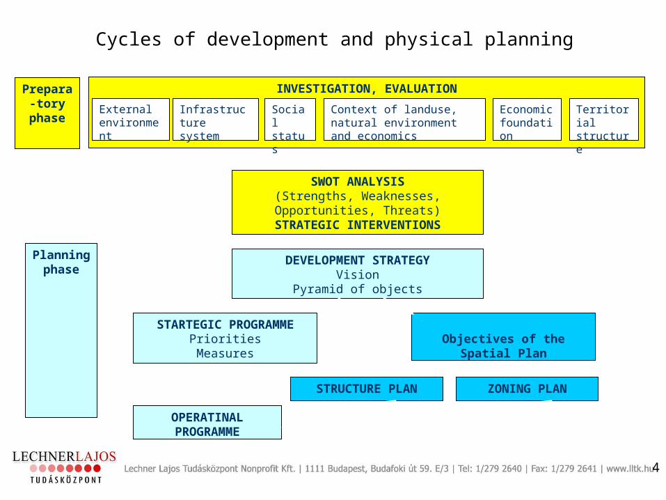
Cycles of development and physical planning
4
INVESTIGATION, EVALUATION
External environment
Social status
Context of landuse, natural environment and economics
Economic foundation
Infrastructure system
Territorial structure
Prepara-tory
phase
SWOT ANALYSIS(Strengths, Weaknesses, Opportunities,
Threats)STRATEGIC INTERVENTIONS
DEVELOPMENT STRATEGYVision
Pyramid of objects
Planning phase
STARTEGIC PROGRAMMEPrioritiesMeasures
Objectives of the Spatial Plan
OPERATINAL PROGRAMME
STRUCTURE PLAN ZONING PLAN

The main role of the plan:•definition of the regional rules of sustainable development (protection zones and land use restriction)•integration of the coutry into the European spatial structure
– validation of European principles (ESDP)– accession to the European infrastructure systems (Helsinki corridors)
•reservation of the territory of future development actions•harmonisation of the lower level planning
Act on National Spatial Plan, approved in 2003

6
#S
#S#S
#S
#S#S#S
#S#S
#S
#S #S#S#S#S
#S#S#S
#S#S#S
#S#S
#S
#S #S#S
#S#S
#S
#S #S#S
#S#S#S #S
#S#S
#S#S#S #S#S
#S #S#S#S#S #S#S
#S
#S#S#S #S #S #S
#S#S#S
#S
#S#S#S
#S#S#S
#S#S #S #S#S#S #S
#S #S#S
#S #S#S#S#S#S #S
#S #S#S
#S
#S
#S
#S#S#S#S #S
#S #S#S#S
#S#S#S#S
#S#S #S
#S#S #S#S
#S#S#S
#S#S#S
#S#S
#S #S
#S#S #S
#S #S#S#S#S
#S#S#S
#S #S#S #S
#S#S#S#S
#S#S
#S#S
#S #S #S#S#S#S #S
#S#S
#S#S #S#S#S #S#S#S #S
#S#S#S
#S#S#S #S#S #S #S#S#S#S #S#S #S
#S#S
#S#S#S #S
#S
#S#S#S#S #S#S#S #S
#S
#S#S
#S#S #S#S
#S #S#S#S
#S#S#S #S#S#S
#S#S #S#S
#S#S #S#S
#S#S #S#S#S#S#S
#S #S #S #S#S
#S #S#S #S#S #S#S#S
#S#S #S#S#S#S #S#S#S #S
#S#S
#S #S#S
#S #S#S #S #S#S#S #S
#S#S#S
#S#S#S #S
#S #S #S#S
#S#S
#S#S
#S#S #S #S#S#S#S#S
#S
#S #S#S#S
#S
#S#S #S
#S#S #S #S#S#S#S #S #S
#S#S#S
#S #S #S
National Spatial Plan Future land use
7
#Y
%U
%U
%U
$
$
$
#S
#S#S
#S
#S
#S#S
#S
#S
#S
#S#S
#S#S
#S
#S#S#S
#S#S
#S#S
#S
#S
#S#S#S
#S
#S
#S
#S#S#S
#S#S
#S#S
#S
#S
#S
#S#S #S#S
#S#S#S#S
#S #S
#S
#S
#S
#S#S #S #S
#S
#S
#S#S
#S
#S#S
#S
#S
#S
#S#S
#S#S #S#S
#S
#S#S #S
#S
#S #S#S
#S#S #S
#S #S#S
#S
#S#S
#S#S#S
#S#S #S
#S#S
#S#S
#S
#S#S
#S
#S
#S#S
#S
#S#S #S
#S#S #S
#S#S
#S#S
#S
#S #S#S#S
#S#S
#S
#S
#S#S
#S
#S #S
#S #S#S#S
#S#S
#S
#S#S#S
#S
#S#S
#S
#S
#S
#S
#S #S #S#S
#S#S
#S#S #S#S
#S#S#S#S
#S
#Se
"
IV.WIEN(NÜRNBERG)
VII.DUNA
Gyõr
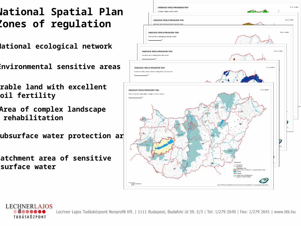
National Spatial PlanLand use and infrastructure systems
8
•National ecological network
•Environmental sensitive areas
•Arable land with excellent soil fertility
•Area of complex landscape rehabilitation
•Subsurface water protection area
•Catchment area of sensitive surface water
National Spatial PlanZones of regulation

TICAD Tisza / Tisa Catchment Area Development
Excpected results
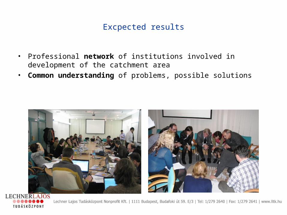
• Professional network of institutions involved in development of the catchment area
• Common understanding of problems, possible solutions

Excpected results
• Common information and data base
• Analysis of the state and perspective of the area: national studies and a synthesis of these analyses
• Elaboration of a common strategy towards the interlinked objectives of water management, land-use consolidation, environmental rehabilitation, nature conservation, economic diversification as well as social progress with the help of development and use of an integrated territorial assessment tool
• Elaboration of local strategies in three pilot areas representing typical issues of the area, discussion, consultations
• Formulation of policy recommendations for national, regional and specific local level
Excpected results
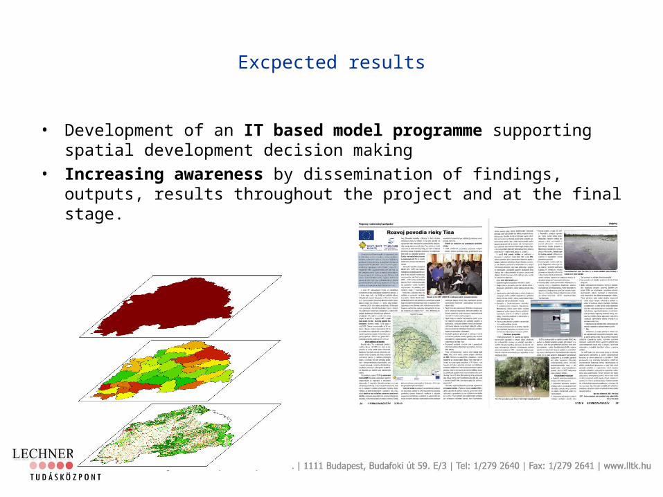
• Development of an IT based model programme supporting spatial development decision making
• Increasing awareness by dissemination of findings, outputs, results throughout the project and at the final stage.