1) platform and deployment - intellevue.com · insightful decisions. by supporting industry...
TRANSCRIPT

2.2 New Features and Benefits in MapInfo Professional v10.0 1) Platform and Deployment Key Customer Benefits: Ø MapInfo Professional’s diverse deployment options are designed to meet IT
environment and management needs Ø MapInfo Professional v10.0 IT friendly installation options allow organizations to
choose the right deployment option that best meets their needs Supported Operating Systems § Desktop Operating Systems:
• Windows XP SP3 • Vista Ultimate SP1 • Windows Vista Ultimate 64Bit • Windows 7 Beta (Smoke Test only)
§ Server Operating Systems
•Windows 2003 server Enterprise •Windows 2003 Server with Citrix 4.X •Windows 2008 Server (Smoke Test)
§ Additional Deployment Capabilities:
o Workgroup installation option allows multiple users to share user customizable files and symbols
o Silent installation and silent product activation options o Support for activating licenses through a proxy server
2) Data Access and Interoperability Key Customer Benefit: Organizations often require that data produced by different technologies needs to be accessible and usable in a single environment. MapInfo Professional’s enhanced ability to access data directly from multiple data sources enables users to apply the power of location and spatial analysis to their data directly in its original format with minimal effort. Example Use Case: A marketing analyst performs target marketing analysis needs to overlay his company’s customer data which resides in an MS SQL database with company infrastructure data that is available as CAD files as well as prospect data that is in MS Excel format. This effort requires the analyst to access multiple data sources and formats in order to perform the analysis. MapInfo Professional makes this task easy, direct and simple.
Remote Database Access
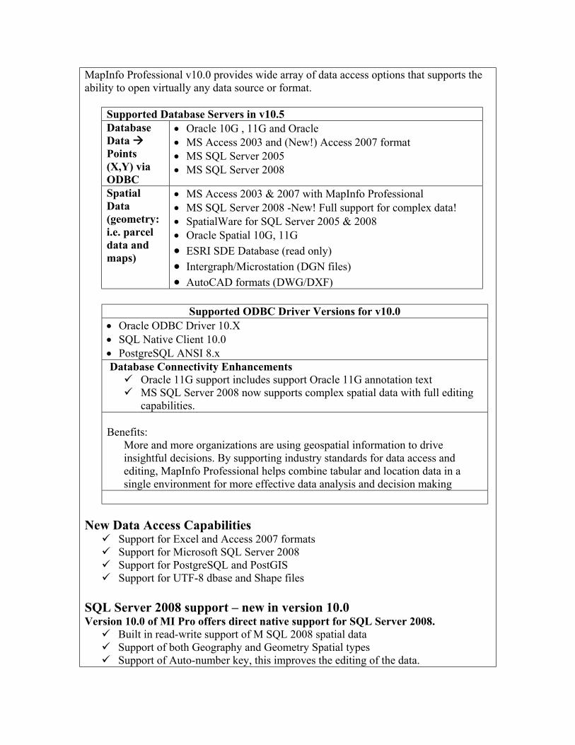
MapInfo Professional v10.0 provides wide array of data access options that supports the ability to open virtually any data source or format.
Supported Database Servers in v10.5 Database Data à Points (X,Y) via ODBC
• Oracle 10G , 11G and Oracle • MS Access 2003 and (New!) Access 2007 format • MS SQL Server 2005 • MS SQL Server 2008
Spatial Data (geometry: i.e. parcel data and maps)
• MS Access 2003 & 2007 with MapInfo Professional • MS SQL Server 2008 -New! Full support for complex data! • SpatialWare for SQL Server 2005 & 2008 • Oracle Spatial 10G, 11G • ESRI SDE Database (read only) • Intergraph/Microstation (DGN files) • AutoCAD formats (DWG/DXF)
Supported ODBC Driver Versions for v10.0
• Oracle ODBC Driver 10.X • SQL Native Client 10.0 • PostgreSQL ANSI 8.x Database Connectivity Enhancements ü Oracle 11G support includes support Oracle 11G annotation text ü MS SQL Server 2008 now supports complex spatial data with full editing
capabilities. Benefits:
More and more organizations are using geospatial information to drive insightful decisions. By supporting industry standards for data access and editing, MapInfo Professional helps combine tabular and location data in a single environment for more effective data analysis and decision making
New Data Access Capabilities ü Support for Excel and Access 2007 formats ü Support for Microsoft SQL Server 2008 ü Support for PostgreSQL and PostGIS ü Support for UTF-8 dbase and Shape files
SQL Server 2008 support – new in version 10.0 Version 10.0 of MI Pro offers direct native support for SQL Server 2008. ü Built in read-write support of M SQL 2008 spatial data ü Support of both Geography and Geometry Spatial types ü Support of Auto-number key, this improves the editing of the data.
ü Included EasyLoader support to populate the database Note that version 9.5 of MI Pro supported SQL Server 2008 with read access only. Our support for SQL Server 2008 is benefiting from our many years of working with Spatial database systems, including Oracle and our own SpatialWare technology for SQL Server. We are experts in working with spatial database systems. PostgreSQL and PostGIS support – new in version 10.0 PostgreSQL is an open source database system. PostGIS is a spatial extension to PostgreSQL that offers storage, management and manipulation of complex spatial data. Added support for Postgre SQL and PostGIS ü Built in read-write support of PostGIS spatial data ü Included EasyLoader support to populate the database ü Support of X,Y points of PostgreSQL database – PostgreSQL users that are not
using the PostGIS extension can still work with point data. Our support for PostGIS is benefiting from our many years of working with Spatial database systems, including Oracle and our own SpatialWare technology for SQL Server. We are experts in working with spatial database systems.
Excel 2007 and Access 2007 support Added Support of Excel 2007 file format – Extend your investment in Office 2007 ü Open .xlsx files directly ü .xlsx can contain up million records ü .XLS continues to be supported
Added Support of MS Access 2007 file format – Extend your investment in Office 2007 ü Open .accdb directly ü .mdb continues to be supported
Benefit: Working with the latest Microsoft Excel and Access formats in previous versions of MapInfo Professional meant that you had to save copies of the data into earlier versions. This is no longer necessary with MI Pro v10.0 UTF-8 Support (Unicode support) in dbf files ü Ability to read DBF files with data stored in UTF-8 encoding. ü DBF files can be a part of Shapefile data. Benefits: UTF-8 encoding offers our customers the ability to read dbf files that contain characters from multiple character sets. In practical terms this means a user could have a single dbf file that contains with names in it from a number of different

languages.
As compared to previous versions of MapInfo Professional, only a single character set could be used at a time. An example of this limitation is that we could not display data containing values in the French, Chinese, Russian and Arabic languages all at once. In previous versions of MI Pro, a user could display any one language at a time but not multiple languages at once in the same table. Unicode support is required for this and UTF-8 is a Unicode character set.
Remember this is read-only support. 3) Better Looking Maps Key Customer Benefit: One of the key benefits our customers can gain from using a MapInfo Professional is the ability to share their data analysis and maps with their colleagues in a way that is visually appealing and easy to read. When maps can be understood and valued by non-location practitioners, the value of maps greatly increases. MapInfo Professional includes numerous options for producing maps that are pleasing and easy to read. Flexible output options ensure that there is a suitable output method for sharing results for every situation. This in turn helps the rest of the organization to benefit from the work done with MapInfo Professional. Use Case Example in Telecommunications: An analyst in the telecommunications industry needs to view a prospect map focused around the coverage provided by the carrier’s network. Segmenting the geographic regions by demographic and socioeconomic profiles will aid marketers in creating products that are better suited to the target demographic population. The final map will highlight high population areas that are within the network. Using this information, marketers can develop products and services for the specific market demographics. When products are designed with target customers in mind, product adoption rate goes up and both the customer as well as the organization benefit. The value of easy to read maps: In order to effectively communicate demographic information for a specific geography, the map can serve as an effective vehicle to convey the opportunity. Specifically, carrier’s geographic coverage areas, high population areas and their dominant demographic profiles should be clearly indicated. Reference data such as city street data, aerial imagery and elevation maps are also helpful in aiding the map reviewer to quickly become familiar with the location. Properly coloured layers, effective use of translucency and colours, consistent symbology, a scale bar and easy to read labels are just a few of the necessary elements for creating easy to read maps.

New and Updated Features in v10.0 for creating better looking maps
ü New Scalebar – embedded in map and updates automatically ü Create Layered PDF output.
Benefits
New Scalebar By having a setting to automatically try several locations to best place labels around points and centroids means users will get more descriptive maps without spending a long time positioning labels by hand. Users also get control over curved labelling overhang which is useful in situations where a street name that runs longer than the street section. More control means producing clearer maps in less time.
Layered PDF PDF files are an industry standard way of distributing information. Layered PDF offers great flexibility by meeting many needs for distributing maps throughout an organization. ü MI Pro v10 will ship with a printer driver that creates layered PDF files. This
capability will work with both Map windows and Layout windows. ü The new Group layers added in v10.0 are also supported ü When viewing a map in a PDF file, the map reader can turn layers off and on to
customize the map view. The layers that contain the map labels and the
geography layers can be turned on/off independently. ü When viewing a Layout window in a PDF file that contains multiple maps, each
individual map will have its own visibility control and separate layer list. This means each map can be controlled independently in the PDF file.
4) Ease of Use and Improved Productivity
Key Customer Benefit: MapInfo Professional v10.0 offers major improvements in day to day tasks in using the software. These changes have made MI Pro both easier to learn and easier to use in significant ways.
ü New Layer Control ü New Toolbars and Menu system ü New Proportion Overlap tool
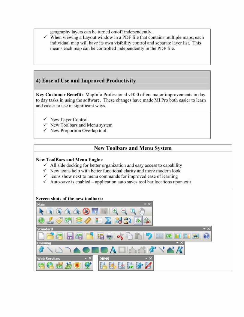
New Toolbars and Menu System
New ToolBars and Menu Engine ü All side docking for better organization and easy access to capability ü New icons help with better functional clarity and more modern look ü Icons show next to menu commands for improved ease of learning ü Auto-save is enabled – application auto saves tool bar locations upon exit
Screen shots of the new toolbars:
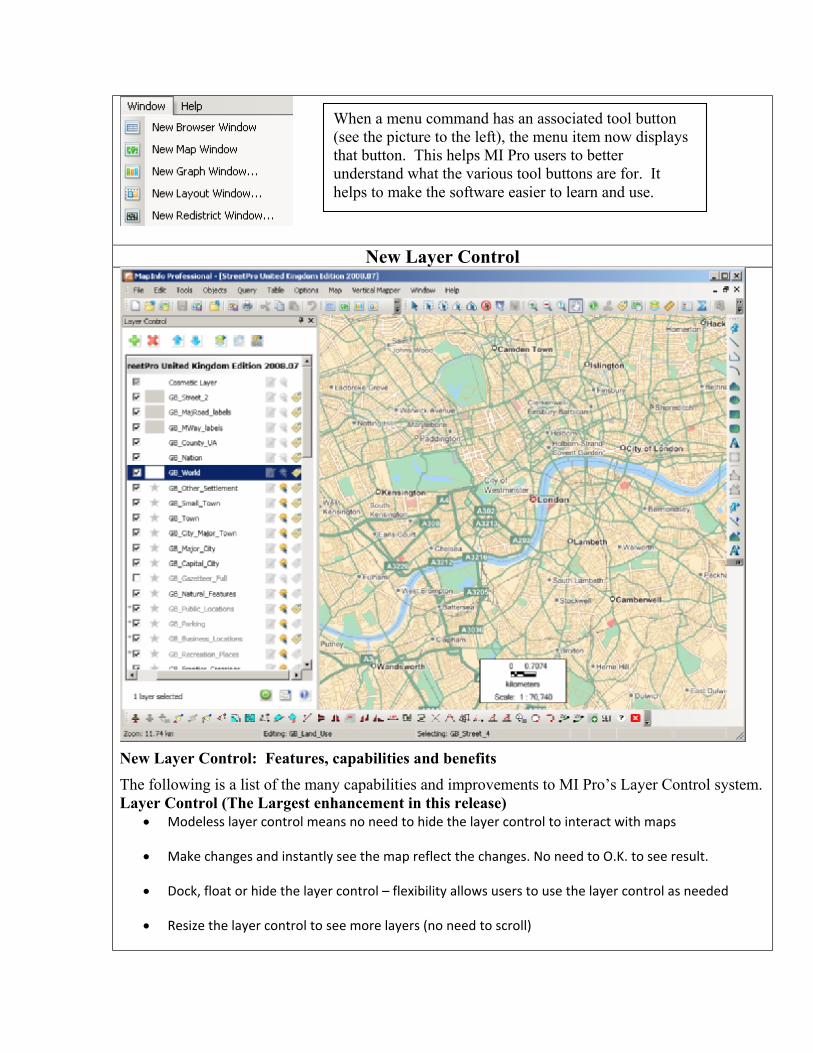
New Layer Control
New Layer Control: Features, capabilities and benefits The following is a list of the many capabilities and improvements to MI Pro’s Layer Control system. Layer Control (The Largest enhancement in this release)
• Modeless layer control means no need to hide the layer control to interact with maps
• Make changes and instantly see the map reflect the changes. No need to O.K. to see result.
• Dock, float or hide the layer control – flexibility allows users to use the layer control as needed
• Resize the layer control to see more layers (no need to scroll)
When a menu command has an associated tool button (see the picture to the left), the menu item now displays that button. This helps MI Pro users to better understand what the various tool buttons are for. It helps to make the software easier to learn and use.
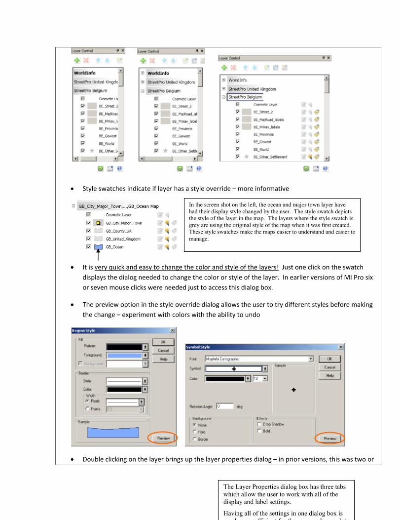
• Style swatches indicate if layer has a style override – more informative
• It is very quick and easy to change the color and style of the layers! Just one click on the swatch displays the dialog needed to change the color or style of the layer. In earlier versions of MI Pro six or seven mouse clicks were needed just to access this dialog box.
• The preview option in the style override dialog allows the user to try different styles before making the change – experiment with colors with the ability to undo
• Double clicking on the layer brings up the layer properties dialog – in prior versions, this was two or
In the screen shot on the left, the ocean and major town layer have had their display style changed by the user. The style swatch depicts the style of the layer in the map. The layers where the style swatch is grey are using the original style of the map when it was first created. These style swatches make the maps easier to understand and easier to manage.
The Layer Properties dialog box has three tabs which allow the user to work with all of the display and label settings.
Having all of the settings in one dialog box is much more efficient for the users and saves lots

three clicks at least
• All three types of setting results can be viewed in Preview mode and adjusted as needed before making them final – All layer settings can be managed and previewed in a single step
• Multiple layers can be selected and Layer properties be accessed. Settings such as Display, Zoom, Label Placement and Label Rules can all be applied to multiple layers at once. This is a tremendous time saver!
In the map above, the user has selected five layers and has brought up the dialog box that is used to change the

colors, styles and labels. All five layers can be changed at once. As an example changing the color of all five layers at once can be done in twelve mouse clicks. The same operation in earlier versions of MI Pro would take more than 40 mouse clicks!
• Layers from different maps can also be selected and changed in the same operation!
• Layers with different geometry types can be selected as well (i.e. points, lines & regions)
• The hotlink feature now includes the ability to set an "alias" expression for each hotlink definition. This allows for a more user friendly description of the link when we popup a list of links.
• Right click menu for faster access to frequently performed layer operations:
o Access to layer level menu is available (i.e. right click menu).
o A subset of right click menu is also available when multiple layers are selected (Lable Font and Make Other Layers non-Selectable)

• Visibility, Selectability and Label checkmarks are available at all times. They can be changed when one or more layers are selected. This is another change that saves users many mouse clicks.
• Layers can be selected sequentially or sparsely (using the CTRL+Click option)
• Layers from multiple maps can be selected as well – all three settings (visability, Selectability and Labels) are available for all selected layers
• Status at the bottom of layer control indicates the number of layers selected – particularly useful when selected layers are not in current Layer List view
• Layer Control offers Pause/Resume option – useful when making many display/property changes at once – this improves performance by reducing screen redraws.
• Layer control has three modes of operation – Single Map Window, Expand selected window, display all map windows – Each mode offers unique benefits
o Single Map Window – cleanest least amount of layer info – most popular
o Expand selected window – Useful when working with different windows individually. Clicking on window title in the layer control switches the map focus to that map

o Display all Maps Mode – useful when one needs to coordinate look and feel between maps
• Map Window title can be changed via right click menu
• Right clicking on map window title in layer control enables quick access to map properties dialog
• Multiple selected layers can be reordered or removed as one unit
• Selecting objects in the map highlights the corresponding layer name in the Layer Control – easy finding of layers
• Group Layers: Ability to add Group layers is available
o Simplify layer list view
o Make the finding of important layers easy (exclude them from groups)
o Change visibility of groups of layers in one click
o Drag and Drop layers into group layers (easy way of organizing existing maps)
• Ability to turn on/off warnings when removing layers – flexibility to match your way of working
• Easy way to turn on/off tool-tips
• Tool-tips show fill file path +name + zoom range when zoom range is enabled – More informative

In the map above, note that the tool tip shows the range at which the layer will be visible. A layer that is not visible is listed in grey.
Proportion Overlap Tool – Greater Analytical Capability in an easy to use tool
• New tool to calculate and append proportion overlap is new in version 10.0.
• Example uses
o Retail: Ability to quickly calculate total population of a drive time based on proportional coverage of a another area with that data
o Telco: Ability to quickly calculate any demographic value based on a coverage signal
o Public sector: Given a set of wetland areas it is easy to calculate the percentage of other boundaries, such as a town or municipal boundaries that are composed of wetlands.
§ Benefits
Proportional and area overlap calculations have been available in MI Pro for a long time but the knowledge and skills needed to do these calculations has been fairly high. The addition of a tool designed to simplify this process will make these types of analysis easier to do for a new user of MapInfo Professional.

5) New Projections and Coordinate Systems USNG (United States National Grid) Support:
• Ability to display, center the map or populate points in USNG coordinates
The following EPSG Codes were added Ministry of Transport of Quebec Coordinate Systems:
o “Popular Visualization CRS / Mercator” EPSG:3785
o "NAD27/MTQ Lambert” EPSG:3797
o "NAD83/MTQ Lambert” EPSG:3798
o "NAD83(CSRS)/MTQ Lambert” EPSG:3799
New Projections added: • 36 Coordinate systems for Vietnam
• Support for the Popular Visualization CRS / Mercator coordinate reference system used in Microsoft Virtual Earth and Google Maps