1 making maps: integrative technology for quality journalism j. t. johnson professor and co-director...
Post on 22-Dec-2015
213 views
TRANSCRIPT

1
Making Maps:Making Maps:Integrative Technology Integrative Technology for Quality Journalismfor Quality Journalism
J. T. JohnsonProfessor and Co-director
Institute for Analytic JournalismCollege of Communication - Boston University
t o m @ j t j o h n s o n . c o m
Highway Africa 2001Highway Africa 2001

2/57 HighwayAfrica 2001 — Sept. 2001© J.T.Johnson 2001
http://mmcom.bu.edu/tjohnson/Public/IAJ/Presentations/HA2001.ppt
Objectives
Quick introduction to GIS (Geographical Information Systems/Science) -- definitions and concepts
GIS = a tool for all aspects of publishing and broadcasting News/editorial -- circulation -- advertising --
marketing -- production Whet appetite for the types of stories better
understood and communicated by GIS Trigger some ideas on how to make current
stories better Show that all this is knowable, possible and
affordable

3/57 HighwayAfrica 2001 — Sept. 2001© J.T.Johnson 2001
http://mmcom.bu.edu/tjohnson/Public/IAJ/Presentations/HA2001.ppt
Key points
GIS as important as telecommunications, word processing, spreadsheets and data bases to Digital Age journalists
GIS is not about making maps, per se. It is about analyzing often large sets of data to
generate information – hypotheses, conclusions, insights, new hunches – about widely varied socio-economic phenomena.
Maps are one unique aspect/artifact of the methodology. But not the end product: knowledge and insight are.

4/57 HighwayAfrica 2001 — Sept. 2001© J.T.Johnson 2001
http://mmcom.bu.edu/tjohnson/Public/IAJ/Presentations/HA2001.ppt
Key points
GIS is about being better – more insightful – journalists (Journos good at description, not analysis. GIS will make us better analysts and often supply readers with a better description of event or phenomena.)
GIS is about literally showing our readers stories in ways they can quickly grasp.

5/57 HighwayAfrica 2001 — Sept. 2001© J.T.Johnson 2001
http://mmcom.bu.edu/tjohnson/Public/IAJ/Presentations/HA2001.ppt
Key points
GIS is a rich challenging tool that should be employed throughout the media organization. As such, promotes shared learning and insights.
A terrific “I didn’t know that!” device for managers, journos and readers

6/57 HighwayAfrica 2001 — Sept. 2001© J.T.Johnson 2001
http://mmcom.bu.edu/tjohnson/Public/IAJ/Presentations/HA2001.ppt
Database with geocodes
Hardware
What is needed for GIS?
User skills
GIS Software

7/57 HighwayAfrica 2001 — Sept. 2001© J.T.Johnson 2001
http://mmcom.bu.edu/tjohnson/Public/IAJ/Presentations/HA2001.ppt
What is GIS- Layers concept illustrated

8/57 HighwayAfrica 2001 — Sept. 2001© J.T.Johnson 2001
http://mmcom.bu.edu/tjohnson/Public/IAJ/Presentations/HA2001.ppt
Quick Power of Maps-Table

9/57 HighwayAfrica 2001 — Sept. 2001© J.T.Johnson 2001
http://mmcom.bu.edu/tjohnson/Public/IAJ/Presentations/HA2001.ppt
Quick Power of Maps
African Internet Connection Speeds
1997 2000Source: http://www3.sn.apc.org/africa/afrmain.htm

10/57 HighwayAfrica 2001 — Sept. 2001© J.T.Johnson 2001
http://mmcom.bu.edu/tjohnson/Public/IAJ/Presentations/HA2001.ppt
Quick Power of Maps-Same Data
ANGOLA 12.09 3023 1684 4000 82 5 4 192

11/57 HighwayAfrica 2001 — Sept. 2001© J.T.Johnson 2001
http://mmcom.bu.edu/tjohnson/Public/IAJ/Presentations/HA2001.ppt
Quick Power of Maps:Same Data/Bar Chart

12/57 HighwayAfrica 2001 — Sept. 2001© J.T.Johnson 2001
http://mmcom.bu.edu/tjohnson/Public/IAJ/Presentations/HA2001.ppt
Quick Power of Maps- Same Data

13/57 HighwayAfrica 2001 — Sept. 2001© J.T.Johnson 2001
http://mmcom.bu.edu/tjohnson/Public/IAJ/Presentations/HA2001.ppt
Portland, Oregon Crime Mapping Home page
http://www.portlandpolicebureau.com/crimemapper.html
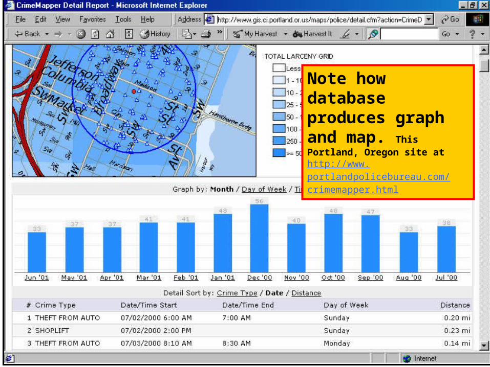
14/57 HighwayAfrica 2001 — Sept. 2001© J.T.Johnson 2001
http://mmcom.bu.edu/tjohnson/Public/IAJ/Presentations/HA2001.ppt
Portland, Oregon Crime mapping
Note how database produces graph and map. This Portland, Oregon site at http://www.portlandpolicebureau.com/crimemapper.html
15/57 HighwayAfrica 2001 — Sept. 2001© J.T.Johnson 2001
http://mmcom.bu.edu/tjohnson/Public/IAJ/Presentations/HA2001.ppt
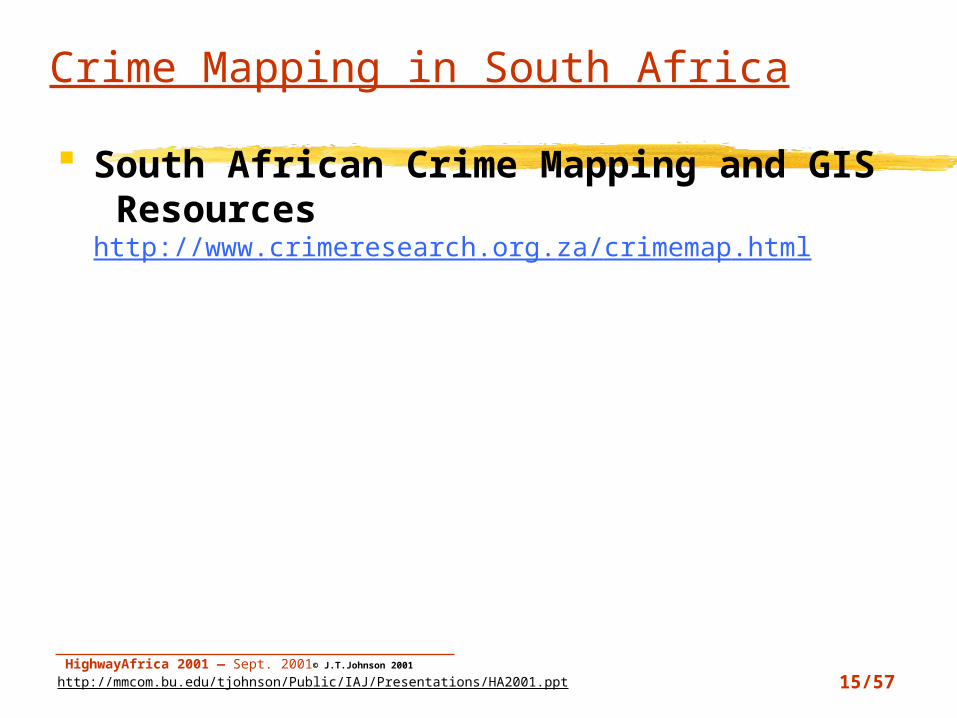
Crime Mapping in South Africa
South African Crime Mapping and GIS Resourceshttp://www.crimeresearch.org.za/crimemap.html

16/57 HighwayAfrica 2001 — Sept. 2001© J.T.Johnson 2001
http://mmcom.bu.edu/tjohnson/Public/IAJ/Presentations/HA2001.ppt
GIS in all departments: Advertising
ADVERTISING Sales? - No. of potential advertisers - # of non-advertisers - Income of town - Age of population

17/57 HighwayAfrica 2001 — Sept. 2001© J.T.Johnson 2001
http://mmcom.bu.edu/tjohnson/Public/IAJ/Presentations/HA2001.ppt
GIS in all departments: Circulation
Circulation? - # of copies per district - # of dealers per route - Penetration - Time of delivery

18/57 HighwayAfrica 2001 — Sept. 2001© J.T.Johnson 2001
http://mmcom.bu.edu/tjohnson/Public/IAJ/Presentations/HA2001.ppt
Route mapping-DeliveryRoute
Route Mapping

19/57 HighwayAfrica 2001 — Sept. 2001© J.T.Johnson 2001
http://mmcom.bu.edu/tjohnson/Public/IAJ/Presentations/HA2001.ppt
Newspaper Route Mapping Resources
http://www.esri.com/software/arclogistics/index.html
ESRI Routing bibliography http://www.esri.com/software/arclogistics/whatsnew.html
RealAudio clips describing ArcLogistics Route http://gis.esri.com/esriclips/clip.cfm?ClipID=57 http://gis.esri.com/esriclips/clip.cfm?ClipID=55
Fleet mgmt. and trackinghttp://www.gisvisionmag.com/software_reviews/fleet.pdf

20/57 HighwayAfrica 2001 — Sept. 2001© J.T.Johnson 2001
http://mmcom.bu.edu/tjohnson/Public/IAJ/Presentations/HA2001.ppt
GIS in all departments: Production
Production? - Prod. employees homes - Toxic waste sites - Copies of varied editions
or products

21/57 HighwayAfrica 2001 — Sept. 2001© J.T.Johnson 2001
http://mmcom.bu.edu/tjohnson/Public/IAJ/Presentations/HA2001.ppt
How Production can use GIS
Press status? Repair reports Equipment maintenance schedule
Facilities management Clickable Campus #1

22/57 HighwayAfrica 2001 — Sept. 2001© J.T.Johnson 2001
http://mmcom.bu.edu/tjohnson/Public/IAJ/Presentations/HA2001.ppt
GIS in all departments: BackOffice
Back office? - Employee homes - Accounts due - Travel time to work - Health-care facilities

23/57 HighwayAfrica 2001 — Sept. 2001© J.T.Johnson 2001
http://mmcom.bu.edu/tjohnson/Public/IAJ/Presentations/HA2001.ppt
Backoffice – Facilities Mgmt.
Clickable Campus #1http://www.sfsu.edu/clickmap/sfsumap.htm
Designing work space Allocating office space Tracking office equipment Building Maintenance

24/57 HighwayAfrica 2001 — Sept. 2001© J.T.Johnson 2001
http://mmcom.bu.edu/tjohnson/Public/IAJ/Presentations/HA2001.ppt
Personnel
Mapping employees residence Who is available to covering breaking
story? Sharing transportation:
“Suggested” co-op transit “Ride sharing” Adjusting work schedules to avoid traffic
congestion

25/57 HighwayAfrica 2001 — Sept. 2001© J.T.Johnson 2001
http://mmcom.bu.edu/tjohnson/Public/IAJ/Presentations/HA2001.ppt
GIS in EditorialEditorial
-Demographics- Crime - Housing- Businesses- Voting patterns/places- Education- Campaign Contributions
- Public Health - Taxation- Church membership- Environment- Traffic- Urban sprawl- Political negotiations (e.g. India and Pakistan, Ecuador and Peru, Guatemala and Belize, Russia and Japan, Britain and Argentina)
- Robin sightings

26/57 HighwayAfrica 2001 — Sept. 2001© J.T.Johnson 2001
http://mmcom.bu.edu/tjohnson/Public/IAJ/Presentations/HA2001.ppt
How Editors Use GIS
Fresno [California] Bee Methamphetamine lab story http://www.valleymeth.com/graphics/superlabs.html
Philadelphia Inquirer’s daily commuter patterns
San Jose Mercury News projected mud slides, building permits
Charlotte Observer: “Deciding Desegregation” http://www.charlotte.com/observer/special/deseg/docs/0110about.htm

27/57 HighwayAfrica 2001 — Sept. 2001© J.T.Johnson 2001
http://mmcom.bu.edu/tjohnson/Public/IAJ/Presentations/HA2001.ppt
PhillyNgbh1

28/57 HighwayAfrica 2001 — Sept. 2001© J.T.Johnson 2001
http://mmcom.bu.edu/tjohnson/Public/IAJ/Presentations/HA2001.ppt
PhillyNgbh2

29/57 HighwayAfrica 2001 — Sept. 2001© J.T.Johnson 2001
http://mmcom.bu.edu/tjohnson/Public/IAJ/Presentations/HA2001.ppt
PhillyNgbh3

30/57 HighwayAfrica 2001 — Sept. 2001© J.T.Johnson 2001
http://mmcom.bu.edu/tjohnson/Public/IAJ/Presentations/HA2001.ppt
PhillyNgbh4

31/57 HighwayAfrica 2001 — Sept. 2001© J.T.Johnson 2001
http://mmcom.bu.edu/tjohnson/Public/IAJ/Presentations/HA2001.ppt
How Editors Use GIS
Fresno [California] Bee Methamphetamine lab story http://www.valleymeth.com/graphics/superlabs.html
Philadelphia Inquirer’s daily commuter patternshttp://www.smartraveler.com/scripts/phlmap.asp?
city=phl&cityname=Philadelphia Charlotte Observer: “Deciding
Desegregation” http://www.charlotte.com/observer/special/deseg/docs/0110about.htm

32/57 HighwayAfrica 2001 — Sept. 2001© J.T.Johnson 2001
http://mmcom.bu.edu/tjohnson/Public/IAJ/Presentations/HA2001.ppt
How reporters use GIS
Census analysis/story telling USAToday
http://www.usatoday.com/news/census/index.htm Weather
Hurricane Andrew Crime mapping
Crime Mapping Research Centerhttp://www.ojp.usdoj.gov/cmrc/
Crime mapping tutorial http://www.gis.heinz.cmu.edu/gistutorial/
Economics, education, urban development, taxation, voting patterns, environment, traffic

33/57 HighwayAfrica 2001 — Sept. 2001© J.T.Johnson 2001
http://mmcom.bu.edu/tjohnson/Public/IAJ/Presentations/HA2001.ppt
USAToday
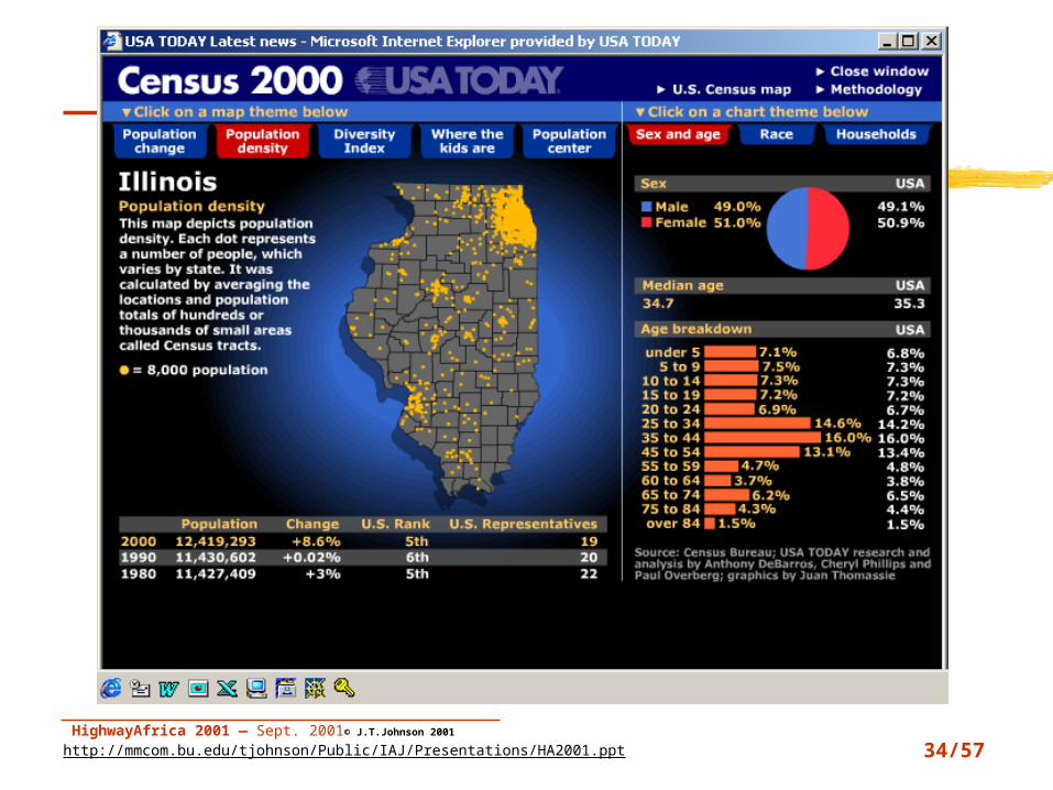
34/57 HighwayAfrica 2001 — Sept. 2001© J.T.Johnson 2001
http://mmcom.bu.edu/tjohnson/Public/IAJ/Presentations/HA2001.ppt
USAToday
35/57 HighwayAfrica 2001 — Sept. 2001© J.T.Johnson 2001
http://mmcom.bu.edu/tjohnson/Public/IAJ/Presentations/HA2001.ppt
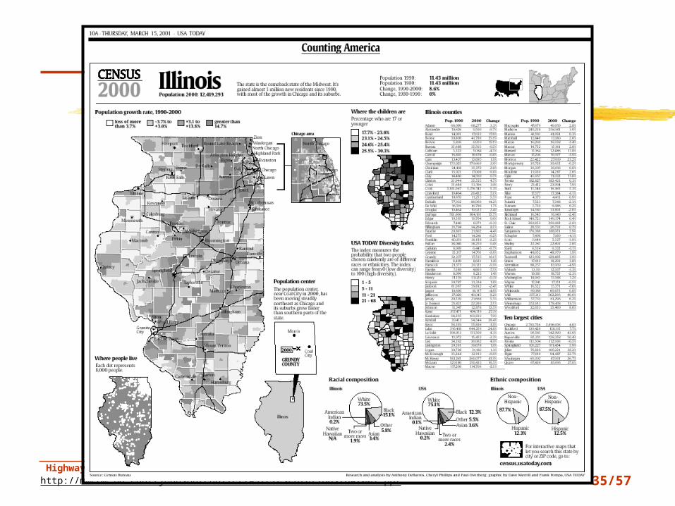
USA Today

36/57 HighwayAfrica 2001 — Sept. 2001© J.T.Johnson 2001
http://mmcom.bu.edu/tjohnson/Public/IAJ/Presentations/HA2001.ppt
USA Today

37/57 HighwayAfrica 2001 — Sept. 2001© J.T.Johnson 2001
http://mmcom.bu.edu/tjohnson/Public/IAJ/Presentations/HA2001.ppt
How reporters use GIS
Census analysis/story telling USAToday
http://www.usatoday.com/news/census/index.htm
Crime mapping Crime Mapping Research Center
http://www.ojp.usdoj.gov/cmrc/ Crime mapping tutorial
http://www.gis.heinz.cmu.edu/gistutorial/

38/57 HighwayAfrica 2001 — Sept. 2001© J.T.Johnson 2001
http://mmcom.bu.edu/tjohnson/Public/IAJ/Presentations/HA2001.ppt
Weather-Hurricane Andrew
Weather - Hurricane Andrew

39/57 HighwayAfrica 2001 — Sept. 2001© J.T.Johnson 2001
http://mmcom.bu.edu/tjohnson/Public/IAJ/Presentations/HA2001.ppt
Orange County, California Bus Study
Orange County, California
Bus Study

40/57 HighwayAfrica 2001 — Sept. 2001© J.T.Johnson 2001
http://mmcom.bu.edu/tjohnson/Public/IAJ/Presentations/HA2001.ppt
3DTaxiCrimeMapView13D view of Taxi Crime

41/57 HighwayAfrica 2001 — Sept. 2001© J.T.Johnson 2001
http://mmcom.bu.edu/tjohnson/Public/IAJ/Presentations/HA2001.ppt
3DTaxiCrimeMapView2Rotated 3D view of Taxi Crime
42/57 HighwayAfrica 2001 — Sept. 2001© J.T.Johnson 2001
http://mmcom.bu.edu/tjohnson/Public/IAJ/Presentations/HA2001.ppt
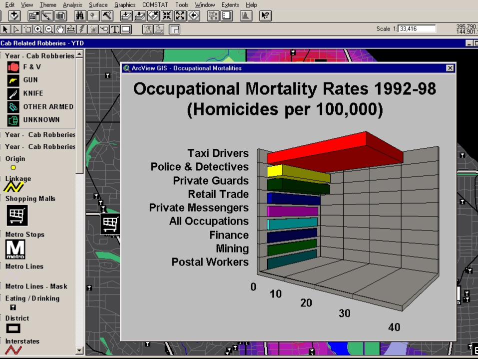
3DTaxiCrimeGraph

43/57 HighwayAfrica 2001 — Sept. 2001© J.T.Johnson 2001
http://mmcom.bu.edu/tjohnson/Public/IAJ/Presentations/HA2001.ppt
How reporters use GIS
Census analysis/story telling USAToday
http://www.usatoday.com/news/census/index.htm Weather
Hurricane Andrew Crime mapping
Crime Mapping Research Centerhttp://www.ojp.usdoj.gov/cmrc/
Crime mapping tutorial http://www.gis.heinz.cmu.edu/gistutorial/
Economics, education, urban development, taxation, voting patterns, environment, traffic

44/57 HighwayAfrica 2001 — Sept. 2001© J.T.Johnson 2001
http://mmcom.bu.edu/tjohnson/Public/IAJ/Presentations/HA2001.ppt
Animated mapping
Maps and images that can be controlled, on the WWW, but the user.
Emphasis is on layering Note, the graphics are tied, in a fundamental
way, to the database. Any map is only as good as the database used to create it.
Manhattan Timeformations: http://www.skyscraper.org/timeformations/animation.html

45/57 HighwayAfrica 2001 — Sept. 2001© J.T.Johnson 2001
http://mmcom.bu.edu/tjohnson/Public/IAJ/Presentations/HA2001.ppt
Concept Mapping Intellectual – or conceptual space --
geography How are ideas related? How are people or places with or tied to
ideas/concepts related? Where is cyberspace? How to map it?
Atlas of Cyberspace Web Mapping
http://www.cybergeography.org/atlas/web_sites.html
Mapping how people use a web sitehttp://mappa.mundi.net/maps/maps_022/
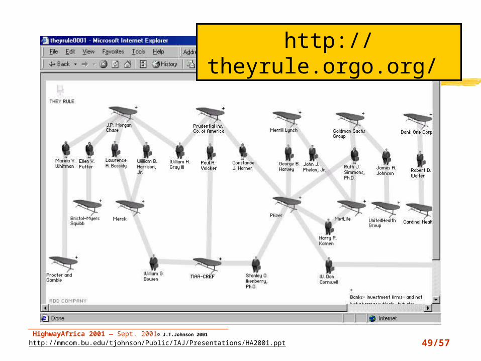
Show me the Power Players in a society?http://theyrule.orgo.org/

46/57 HighwayAfrica 2001 — Sept. 2001© J.T.Johnson 2001
http://mmcom.bu.edu/tjohnson/Public/IAJ/Presentations/HA2001.ppt
Web site content map

47/57 HighwayAfrica 2001 — Sept. 2001© J.T.Johnson 2001
http://mmcom.bu.edu/tjohnson/Public/IAJ/Presentations/HA2001.ppt
Fry’s Web site mapBen Fry's anemone visualization of website
usage

48/57 HighwayAfrica 2001 — Sept. 2001© J.T.Johnson 2001
http://mmcom.bu.edu/tjohnson/Public/IAJ/Presentations/HA2001.ppt
Mapping cyberspaceVR visualisation of Web traffic
49/57 HighwayAfrica 2001 — Sept. 2001© J.T.Johnson 2001
http://mmcom.bu.edu/tjohnson/Public/IAJ/Presentations/HA2001.ppt
PowerPlayers1http://theyrule.orgo.org/

50/57 HighwayAfrica 2001 — Sept. 2001© J.T.Johnson 2001
http://mmcom.bu.edu/tjohnson/Public/IAJ/Presentations/HA2001.ppt
PowerPlayers2

51/57 HighwayAfrica 2001 — Sept. 2001© J.T.Johnson 2001
http://mmcom.bu.edu/tjohnson/Public/IAJ/Presentations/HA2001.ppt
PowerPlayers3

52/57 HighwayAfrica 2001 — Sept. 2001© J.T.Johnson 2001
http://mmcom.bu.edu/tjohnson/Public/IAJ/Presentations/HA2001.ppt
Dynamic Event Mapping
Code-Red (CRv2) worm virus (19 July 2001)
http://caida.packet-pushers.com/newframes-small-log.gif

53/57 HighwayAfrica 2001 — Sept. 2001© J.T.Johnson 2001
http://mmcom.bu.edu/tjohnson/Public/IAJ/Presentations/HA2001.ppt
Editorial
Advertising
Major Points About GIS
Circulation
Production
The hammer and chisel are not the cabinet. (e.g. “The tool is not the product.”)
Skillful use of the tool can be applied to many different products with same data but different objectives
Skillful use of the tool can be applied to many different products with same data and the same objectives. Ergo…
It’s in the interest of all in organization to cooperate in GIS
Focus on the infinitive to transact, not the noun of product

54/57 HighwayAfrica 2001 — Sept. 2001© J.T.Johnson 2001
http://mmcom.bu.edu/tjohnson/Public/IAJ/Presentations/HA2001.ppt
Major trends in JAGIS (Journalism And GIS)
Transparency Easy access to data of all sorts Data-based decision making Vital to informed government, business, culture
Dynamic mapping Data/information when and where we want it
Concept mapping Reflects pervasive interlocking relationships
between people, between ideas, linking decisions to data
Geo-location Real time, wireless location of people, events, resources
Cyber-geographyhttp://www.cybergeography.org/geography_of_cyberspace.html

55/57 HighwayAfrica 2001 — Sept. 2001© J.T.Johnson 2001
http://mmcom.bu.edu/tjohnson/Public/IAJ/Presentations/HA2001.ppt
Conclusion: Why journos need to know about GIS? It can make us better journalists and
improves civic contribution. (Philadelphia data)
Makes the invisible visible Literally shows the story to our readers Helps readers connect with us and vice
versa It can make all aspects of our business
run more efficiently, profitably Government and business are using GIS.
Ergo, we need to at least know enough about how it works to ask informed questions. And if government is not using it, then we should find out why.

56/57 HighwayAfrica 2001 — Sept. 2001© J.T.Johnson 2001
http://mmcom.bu.edu/tjohnson/Public/IAJ/Presentations/HA2001.ppt
Journalism is…
“The central purpose of journalism is to provide
citizens with accurate and reliable information they need to function in a free
society.'‘ Bill Kovach, curator Nieman Foundation Harvard University

57
Making Maps:Making Maps:Integrative Technology for Integrative Technology for
Quality JournalismQuality Journalism
J. T. JohnsonProfessor and Co-director
Institute for Analytic JournalismCollege of Communication - Boston University
t o m @ j t j o h n s o n . c o m
Highway Africa 2001Highway Africa 2001
Related bibliography found at http://mmcom.bu.edu/tjohnson/Public/IAJ/Presentations/HA2001biblio.doc