1-how waterways, glacial melt waters, and … · how waterways, glacial melt waters, and...
TRANSCRIPT
Journal of Earth Science and Engineering 4 (2014) 389-399
How Waterways, Glacial Melt Waters, and Earthquakes Re-aligned Ancient Rivers and Changed Illinois Borders
Kenneth R. Olson1 and Fred Christensen2, 3 1. College of Agricultural, Consumer and Environmental Sciences, University of Illinois, Urbana 61801, Illinois, USA
2. University of Kentucky, Lexington 40507, Kentucky, USA
3. University of Illinois, Urbana 61801, Illinois, USA Received: June 05, 2014 / Accepted: June 20, 2014 / Published: July 25, 2014. Abstract: The borders of Illinois were established when Illinois became a state in 1818. The western border was delineated using the Mississippi River, and the Ohio River was used as the southern border. The eastern border was formed by the Ohio and Wabash Rivers plus the line along latitude 42°30′30″ connecting the Wabash River to Lake Michigan. As initially proposed, the northern border of Illinois would have been 82 km (51 mi) to the south of the current longitude line of 87°31′. This 2,160,000 ha (5,440,000 ac) addition to Illinois resulted in the territory having the required minimum of 40,000 people to qualify as a state. The northern border was moved to allow the linkage of the Great Lakes shipping route to the Illinois and Mississippi River navigation channels. Illinois thus gained a valuable shoreline on Lake Michigan and a location for a shipping port hub which became Chicago. Initially the transfer of goods between these waterways required a portage, but later a shipping canal was created to link the waterways. During the Civil War, Union forces used the connected waterway systems as a northern supply route to avoid the contested Ohio River. Key words: Waterways, Mississippi River, Ohio River, Illinois territory, Illinois borders.
1. Introduction
For more than 100 years prior to 1818, Illinois was known as the Illinois country or Illinois territory (Fig. 1). In the 17th century, the French built trading forts in the Illinois country. Louis Joliet and Father Pierre Marquette suggested a canal from the Illinois River to Lake Michigan to eliminate the portage at Mud Lake, but the canal was never built by the French. At the end of the French and Indian War in 1763, the area was ceded to the British, and was then awarded to the new United States by the Treaty of Paris (1783). When the borders of Kentucky and Indiana borders were established, they formed Illinois’ southern and eastern borders (the Ohio and Wabash Rivers and the longitudinal line (87°31′30″) which extended between the Wabash River and the southernmost tip of Lake
Corresponding author: Kenneth R. Olson, professor,
research fields: soil science and environmental sciences. E-mail:[email protected].
Michigan). The proposed northern boundary in an 1817 plan considered by the US Congress (derived from the Northwest Ordinance) was a straight line from the southernmost tip of Lake Michigan (in Indiana) to the Mississippi River just south of the Rock River confluence with the Mississippi River. Nathaniel Pope, Illinois Territory’s congressional delegate proposed modifying the northern border by moving it 82 km (51 mi) to the north for economic reasons and to give Illinois access to Lake Michigan, the Great Lakes, and the St. Lawrence Seaway. Another reason for the northern border move was unstated but was related to slavery. After the Missouri Comprise of 1820, Illinois would became a northern state and a key part of the Union by 1860. While many in southern Illinois were sympathetic to the confederate cause during the Civil War, most of the state of Illinois was not.
D DAVIDpUBLISHING
How Waterways, Glacial Melt Waters, and Earthquakes Re-aligned Ancient Rivers and Changed Illinois Borders
390
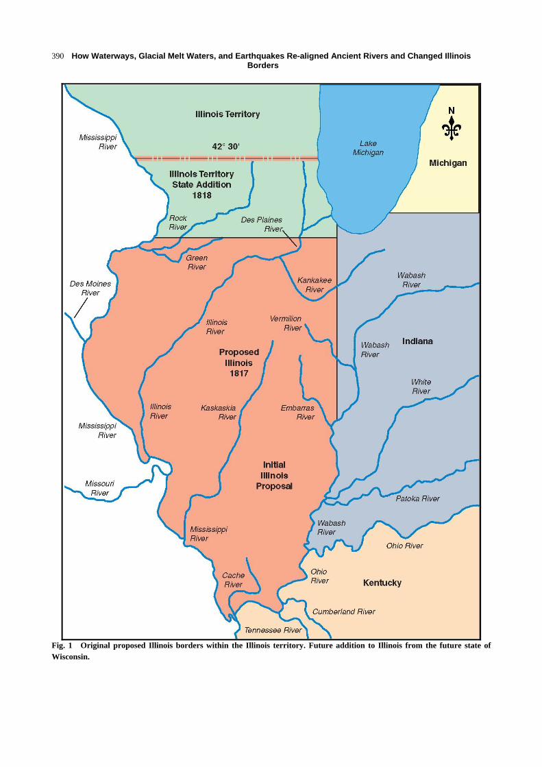
Fig. 1 Original proposed Illinois borders within the Illinois territory. Future addition to Illinois from the future state of Wisconsin.

How Waterways, Glacial Melt Waters, and Earthquakes Re-aligned Ancient Rivers and Changed Illinois Borders
391
Many inhabitants living in northern Illinois territory (the later Wisconsin) objected to the movement of the northern boundary, the loss of the Lake Michigan waterfront and the location for a shipping port. The loss of land, water and population delayed Wisconsin’s development for 30 years. Wisconsin finally became a state in 1849. Nathaniel Pope, with the help of his brother Senator Pope of Kentucky, was able to get Congress to move the northern boundary to its present day location (Fig. 2). The addition of 2,160,000 ha (5,440,000 ac) also raised the population to (nearly) 40,000 which was required for statehood. Illinois became a state in 1818. The port area on Lake Michigan became the future city of Chicago in 1837 and linked the two shipping routes with a portage between a small river that drained into Lake Michigan with Illinois River (Fig. 3). In 1848, the Illinois and Michigan Canal was completed, allowing the shipment of goods between the two waterway systems. With tensions rising and Civil War a possibility, the canal provided the Union with a northern route to ship goods without having to use the Ohio River. After the railroad and canal connected the lakefront to the rest of the state, Chicago grew with incredible speed. Chicago is now the largest city in Illinois, and the greater Chicago area includes three-quarters of the state’s population. The ceding of 2,200 km2 (8,500 mi2) of territory and the lakefront property on Lake Michigan by the US Congress to Illinois as a result of Nathaniel Pope’s efforts altered the fortunes of Wisconsin and Illinois. The 1,260,000 ha (5,440,000 ac) added to Illinois, as a result of the northern boundary shift, include very productive soils. These soils are both Alfisols (timber) such as Hickory and Rozetta and Mollisols (prairie) which include the Drummer and Sable soils.
2. Materials
During the Pleistocene Era, numerous glacial advances covered most of Missouri and Illinois, with the two most recent designated as the Illinoian and
Wisconsinan glaciations. Melt waters from these glaciers contributed to the re-alignment of the Mississippi River [1]. The western boundary of Illinois was the Mississippi River (Fig. 2). However, before the Pleistocene glacial period, the ancient Mississippi River passed much farther to the east, as shown by the blue dashed lines. Today’s lower Illinois River follows its course. This ancient Mississippi River was eventually blocked by the Wisconsin glacier and its terminal moraine was about 12,000 to 15,000 years ago. The ancient Mississippi River then re-aligned itself to its current position which was later used as the western border when Illinois became a state. If the Mississippi River (Fig. 4) had not been re-aligned, the 3 million ha (7.5 million ac) (Fig. 2) would belong to the states of Missouri and Iowa. Before 1803, the land west of the current Mississippi River was controlled by the French and was part of the Louisiana Purchase in that year. After Iowa and Missouri became states, they had a border dispute that was settled by the US Supreme Court. The border between these two states was primarily the 40°35″ latitude line, which if extended into the current area of Illinois between the Illinois and Mississippi rivers (Fig. 2) would determine the acreage each state would have gained if the ancient Mississippi River had not been re-aligned. A total of 1.4 million ha (3.5 million ac) would have gone to Missouri and 1.6 million ha (4 million ac) to Iowa. This area includes some of the most productive soils in Illinois. Most soils were formed under prairie in thick loess and include Muscatune, Osco, Tama and Sable soils. Muscatune is the most productive soil in Illinois for corn and soybean production.
3. Results and Discussion
3.1 Subtraction from Illinois as a Result of Mississippi River Re-routing
Further to the south, the Mississippi River (just south of current Cape Girardeau) was re-routed (Fig. 5) at the end of the Great Ice Age. After the last glacial
How Waterways, Glacial Melt Waters, and Earthquakes Re-aligned Ancient Rivers and Changed Illinois Borders
392
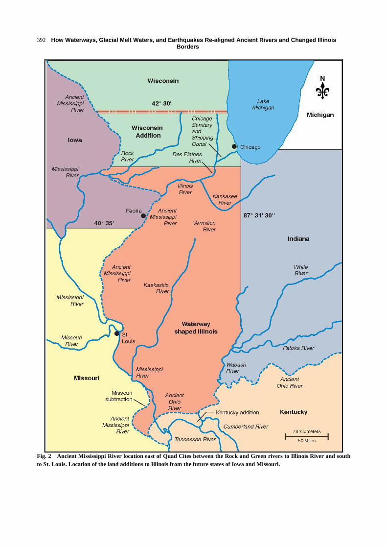
Fig. 2 Ancient Mississippi River location east of Quad Cites between the Rock and Green rivers to Illinois River and south to St. Louis. Location of the land additions to Illinois from the future states of Iowa and Missouri.

How Waterways, Glacial Melt Waters, and Earthquakes Re-aligned Ancient Rivers and Changed Illinois Borders
393
Fig. 3 Starved Rock Lock and dam on the Illinois River waterway.
advance, the melting ice flooded and altered the course of many channels and streams including the Mississippi and Ohio rivers. Approximately 12 to 15 thousand years ago, scientists believe that the Ohio and Mississippi rivers changed course (Fig. 5) south of Cape Girardeau, Missouri. The 9.3 km (6 mi) stretch of the Mississippi River near Thebes, Illinois is unique [2]. It is the only section of the Mississippi River that is in a narrow bedrock lined valley with rock underlying the navigation channel. Some geologists believe heavy seismic activity along the Commerce Lineament about 12,000 years to 15,000 years ago created a fault which helped the Mississippi River cut through the “Thebes gap” and made a new confluence 40 km (25 mi) north of the current
confluence, where the river switched from a braided, meandering river to one that cut through rock. The Mississippi River currently forms the state boundary between Missouri and Illinois. At Thebes, the Mississippi River is now located 47 km (30 miles) to the east (Fig. 5) of where the ancient Mississippi River flowed. Before the 20th century, the Mississippi River migrated rapidly by eroding the outside and depositing on the inside of a river bend. Numerous oxbow lakes mark old positions of the channel that have been abandoned. Early Holocene-Late Wisconsin liquefaction features in western lowlands were induced by a local source possibly by the Commerce fault as a result of earthquake upheaval along the Commerce Geophysical lineament running from the

How Waterways, Glacial Melt Waters, and Earthquakes Re-aligned Ancient Rivers and Changed Illinois Borders
394
Fig. 4 Mississippi River valley near the arch in St. Louis, Missouri.
How Waterways, Glacial Melt Waters, and Earthquakes Re-aligned Ancient Rivers and Changed Illinois Borders
395
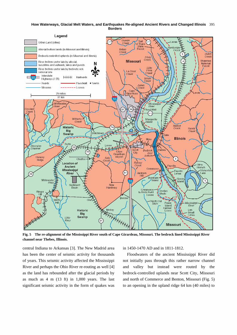
Fig. 5 The re-alignment of the Mississippi River south of Cape Girardeau, Missouri. The bedrock lined Mississippi River channel near Thebes, Illinois.
central Indiana to Arkansas [3]. The New Madrid area has been the center of seismic activity for thousands of years. This seismic activity affected the Mississippi River and perhaps the Ohio River re-routing as well [4] as the land has rebounded after the glacial periods by as much as 4 m (13 ft) in 1,000 years. The last significant seismic activity in the form of quakes was
in 1450-1470 AD and in 1811-1812. Floodwaters of the ancient Mississippi River did
not initially pass through this rather narrow channel and valley but instead were routed by the bedrock-controlled uplands near Scott City, Missouri and north of Commerce and Benton, Missouri (Fig. 5) to an opening in the upland ridge 64 km (40 miles) to

How Waterways, Glacial Melt Waters, and Earthquakes Re-aligned Ancient Rivers and Changed Illinois Borders
396
the southwest. Then the river turned back to the south and merged with the ancient Ohio River near Morely, Missouri. Once floodwaters of the Mississippi River (from the north) and Ohio River (from the east) were able to cut a valley trench along a fault and through the bedrock controlled upland west of Thebes. As a result of the Commerce fault, the distance the Mississippi had to travel was shortened from 78 km (50 miles) to 9.3 km (6 miles). The two historic rivers also once joined at Malden, Missouri; however, the location of the confluence continued to change over time, and is now located south of Cairo, Illinois at Fort Defiance State Park. The confluence of these two mighty rivers created a very rapidly changing channel [4]. It appears that the bedrock-controlled upland was worn away by both rivers after seismic activity and the creation of the Commerce fault contributed to the opening of the bedrock-controlled channel (Fig. 5) after the last glacial advance approximately 12,000 years to 15,000 years ago.
3.2 The Ancient Ohio River and Historic Geological Features of the Cache River Valley
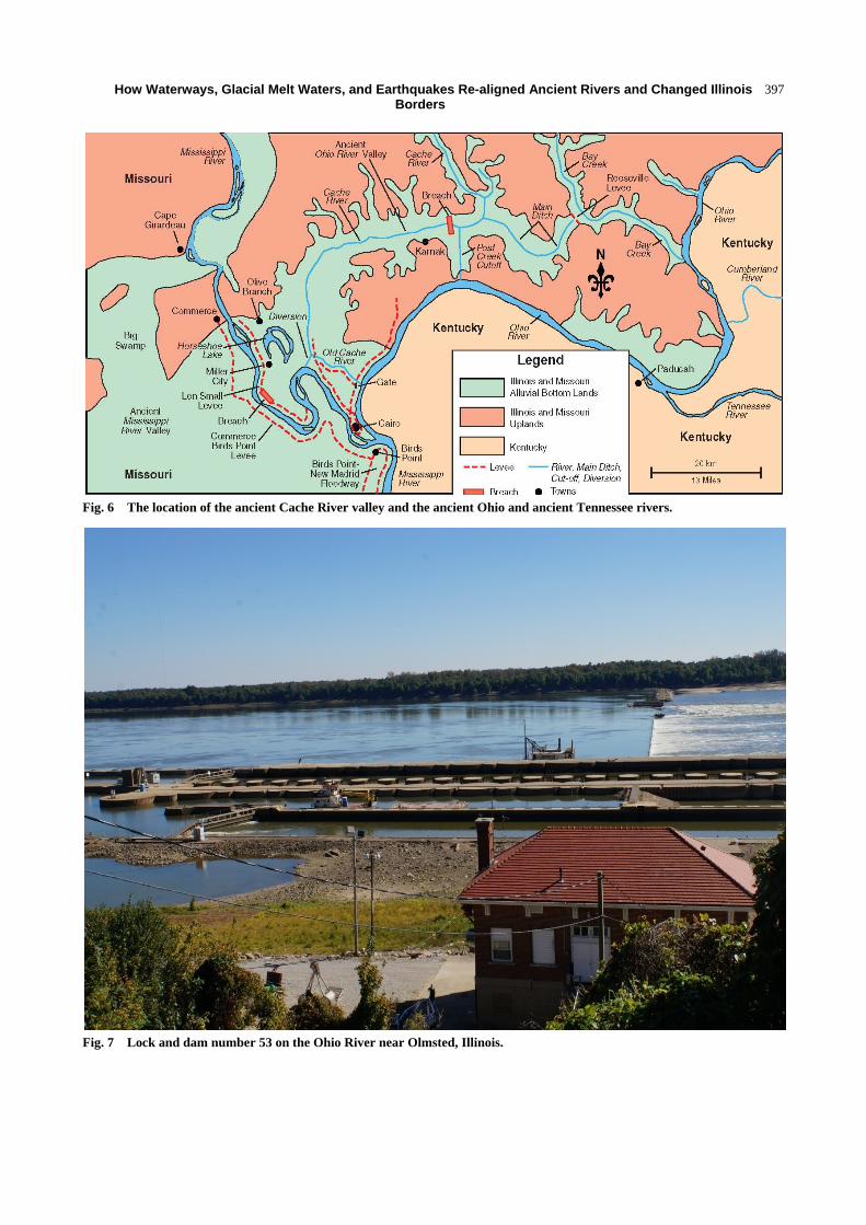
The modern day Cache River Valley of southern Illinois (Fig. 6) has a string of tupelo-cypress swamps, sloughs and shallow lakes, remnants of the ancient Ohio River whose confluence with the Mississippi River was once northwest of Cairo, Illinois. The ancient Ohio River Valley, 80 km (50 mi) long and 2.5-5 km (1.5-3 mi) wide, was formed by the melt waters of northern glaciers as they advanced and retreated in numerous iterations over the last million years. The Mississippi River flowing southward from Minnesota was (and is today) a meandering river of oxbows and cut-offs, continuously eroding banks, re-depositing soil and changing paths. Its historic meandering is particularly apparent in western Alexander County, Illinois, where topographical maps show oxbow swirls and curves, and at Horseshoe Lake, where the ancient Mississippi River once flowed (Fig. 6). The upland hills of the Shawnee National
Forest just north and west of the town of Olive Branch and north of Route 3 give way to a low lying plain between the Mississippi and Ohio rivers. Historically this region has been a delta, confluence, and bottomlands dating back 30,000 to 800,000 years BP with many of the Illinois lands shown on the maps located on both sides of the middle Mississippi River as its channel changed positions over time. As a result, the fertile farmland soils of western Alexander County (Bonnie silt loam, wet, Piopolis silty clay loam, wet, Karnaksilty clay, wet, Petrolia silty clay loam and the Cape and Karnak silt loam) formed in alluvial and lacustrine deposits.
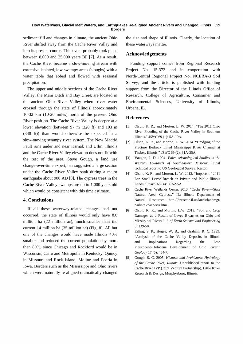
Hydrologically, the Ohio River (Fig. 7) is the main eastern tributary of the Mississippi River. Today it runs along the borders of six states 1,520 km (981 mi) west from Pittsburgh, PA to the Mississippi River confluence at Cairo, Illinois and drains lands west of the continental divide from the Appalachian Mountains encompassing all or part of 14 states. The Ohio River, a southwestern flowing river, was formed between 2.5 and 3 million years ago when glacial ice dammed portions of north flowing rivers. About 625,000 years ago, the ancient Ohio River fed by the Green and Cumberland rivers of Kentucky flowed through the Cache River Basin and was smaller than the current Ohio River [5]. At that time, the Wabash River (Indiana) had not yet formed and the Tennessee River was not a tributary of the Ohio but formed the main channel before the later Ohio River appeared.
During the Woodfordian period (30,000 years BP), the floodwaters from the historic Ohio River watershed drained into eastern Illinois via Bay Creek (Fig. 6) to the northwest and then west through the Cache River Valley through present-day Alexander County, Illinois, where it converged with the Mississippi River near Morely, Missouri, located west of the Horseshoe State Conservation area [4, 6]. The middle Cache River Valley is 2 km (1.3 mi) wide as a result of the previous river having been much larger since it carried waters from the ancient Ohio River Valley and
How Waterways, Glacial Melt Waters, and Earthquakes Re-aligned Ancient Rivers and Changed Illinois Borders
397
Fig. 6 The location of the ancient Cache River valley and the ancient Ohio and ancient Tennessee rivers.
Fig. 7 Lock and dam number 53 on the Ohio River near Olmsted, Illinois.

How Waterways, Glacial Melt Waters, and Earthquakes Re-aligned Ancient Rivers and Changed Illinois Borders
398
Fig. 8 The additions and subtractions to Illinois. The orange area is the net border of Illinois without all the Mississippi and Ohio rivers re-routing and the decision to provide Illinois with lake frontage on Lake Michigan and connecting waterways.
to the local waters from the upper Cache River Valley to the Mississippi River.
Extensive deposits of gravel and sand, some as deep as 49 m (160 ft), rest on the bedrock floor of the
middle and eastern portions of the valley [5] and offer evidence of glacial flooding which carved the valley deeply into the bedrock and then as the water receded, back-filled the valley with sediments. With increasing
How Waterways, Glacial Melt Waters, and Earthquakes Re-aligned Ancient Rivers and Changed Illinois Borders
399
sediment fill and changes in climate, the ancient Ohio River shifted away from the Cache River Valley and into its present course. This event probably took place between 8,000 and 25,000 years BP [7]. As a result, the Cache River became a slow-moving stream with extensive isolated, low swampy areas (sloughs) with a water table that ebbed and flowed with seasonal precipitation.
The upper and middle sections of the Cache River Valley, the Main Ditch and Bay Creek are located in the ancient Ohio River Valley where river water crossed through the state of Illinois approximately 16-32 km (10-20 miles) north of the present Ohio River position. The Cache River Valley is deeper at a lower elevation (between 97 m (320 ft) and 103 m (340 ft)) than would otherwise be expected in a slow-moving swampy river system. The New Madrid Fault runs under and near Karnak and Ullin, Illinois and the Cache River Valley elevation does not fit with the rest of the area. Steve Gough, a land use change-over-time expert, has suggested a large section under the Cache River Valley sank during a major earthquake about 900 AD [8]. The cypress trees in the Cache River Valley swamps are up to 1,000 years old which would be consistent with this time estimate.
4. Conclusions
If all these waterway-related changes had not occurred, the state of Illinois would only have 8.8 million ha (22 million ac), much smaller than the current 14 million ha (35 million ac) (Fig. 8). All but one of the changes would have made Illinois 40% smaller and reduced the current population by more than 80%, since Chicago and Rockford would be in Wisconsin, Cairo and Metropolis in Kentucky, Quincy in Missouri and Rock Island, Moline and Peoria in Iowa. Borders such as the Mississippi and Ohio rivers which were naturally re-aligned dramatically changed
the size and shape of Illinois. Clearly, the location of these waterways matter.
Acknowledgements
Funding support comes from Regional Research Project No. 15-372 and in cooperation with North-Central Regional Project No. NCERA-3 Soil Survey; and the article is published with funding support from the Director of the Illinois Office of Research, College of Agriculture, Consumer and Environmental Sciences, University of Illinois, Urbana, IL.
References
[1] Olson, K. R., and Morton, L. W. 2014. “The 2011 Ohio River Flooding of the Cache River Valley in Southern Illinois.” JSWC 69 (1): 5A-10A.
[2] Olson, K. R., and Morton, L. W. 2014. “Dredging of the Fracture Bedrock Lined Mississippi River Channel at Thebes, Illinois.” JSWC 69 (2): 31A-35A.
[3] Vaughn, J. D. 1994. Paleo-seismological Studies in the Western Lowlands of Southeastern Missouri. Final technical report to US Geological Survey, Reston.
[4] Olson, K. R., and Morton, L. W. 2013. “Impacts of 2011 Len Small Levee Breach on Private and Public Illinois Lands.” JSWC 68 (4): 89A-95A.
[5] Cache River Wetlands Center. 2013. “Cache River—State Natural Area, Cypress.” IL: Illinois Department of Natural Resources. http://dnr.state.il.us/lands/landmgt/ parks/r5/cachervr.htm.
[6] Olson, K. R., and Morton, L.W. 2013. “Soil and Crop Damages as a Result of Levee Breaches on Ohio and Mississippi Rivers.” J. of Earth Science and Engineering 3: 139-58.
[7] Esling, S. P., Huges, W. B., and Graham, R. C. 1989. “Analysis of the Cache Valley Deposits in Illinois and Implications Regarding the Late Pleistocene-Holocene Development of Ohio River.” Geology 17 (5): 434-7.
[8] Gough, S. C. 2005. Historic and Prehistoric Hydrology of the Cache River, Illinois. Unpublished report to the Cache River JVP (Joint Venture Partnership), Little River Research & Design, Murphysboro, Illinois.