1; gulf workbook.pdf · abundance in the gulf of maine during the summer months, when the seasonal...
TRANSCRIPT

. . I !'
:teaching Each Other .< . . . .. .
About the Gulf of Maine Watershed
An Intmdudory Workbook
s, and Postsr Series
d . -~ * ~,.'. :, . ; . . : <. .
. .
-. . -
1 ; .. . A v
. .. . .
A . ,.. .;,
': ..,
- . .. . . ; . .-: . - . >.. ,.:.. 2.: ;r. : ;.,, .._I A A

A Note to Teachers
T here is a wealth of materials available for teachers and stu- dents who want to learn about
the Gulf of Maine ecosystem and the factors that affect living resources in our watershed. More knowledge is emerging every year as scientists and educators study this beautiful and complex natural system.
The Wild Gulf project was created to gather this information together and create an accessible, up-to-date guide for people who want to know how and where to learn about the Gulf of Maine.
This workbook has been written as a companion guide to the Wild Gulf Poster Series and provides some basic information about the Gulf of Maine watershed, suggests ideas for using the Wild Gulf posters in the classroom, and introduces you to the Wild Gulf Almanac, a new publication for teachers, students, and the general public about the Gulf of Maine ecosystem.
The Wild Gulf Almanac is being develoued as a serialized, annotated catalog that covers a comprehensive array of environmental subjects and provides a description of educational materials, facilities, and resources currently available to school systems and individuals who want information about the Gulf of Maine.
We hope that this workbook will be the beginning of a watershed-wide focus for organizing and using educational re- sources about the Gulf of Maine and will encourage you to bring an eco- system-based perspective about living resources to your students.
Information about these and other Wild Gulf materials is available from The Chewonki Foundation in Wiscasset, Maine at (207) 882-7323. Tha Wild Gulf is a joint initiative of the Chewonki Foundation, the U.S. Fish and Wildlife Service's Gulf of Maine Project, and the Wells National Estuarine Research Reserve. The Wild Gulf is funded in part by private contributions, with support from the National Fish and Wildlife Foundation in Washington, D.C.
m e Gulf of Maine Watershed. Welcome Aboard.
I f you turn your world atlas to the page that includes the northeastern portion of the United States and
maritime Canada and look at the Atlantic Ocean there, you are likely to find the words "Gulf of Maine" next to a complex system of political boundaries that describes a dozen or more constituencies on land.
The Gulf of Maine was shaped from a submerged platform that was exposed as dry land 15 million years ago and was sculpted by erosion from rivers that existed during the Tertiary Period. Then, during the Ice Age, glaciers dug further into the stream beds, rounding and enlarging them. When the last glaciers retreated-approximately 13,000 years ago-meltwater flowing to the ocean eroded the channels even further. The
been known as "the sea beside the sea," since its waters are separated from the Atlantic Ocean by a series of shallow submarine shelves-includmg the Nantucket Shoals and Georges and Brown Bank-that extend in a semi- circle from Cape Cod in Massachusetts to Nova Scotia's Cape Sable. There are places on Georges Bank where the sea floor is so high that the water is less than 9 feet (1.8 meters] deep. These underwater rises and plateaus are the walls that separate the Gulf from the rest of the Atlantic Ocean.
The link between the Gulf and the open Atlantic is the Northeast Channel, a deep passage between Georges and Brown Bank that allows the ocean water that has been warmed by the Gulf Stream to enter the Gulf from the south.
result was a topography of deep basins The Labrador Current, however, sweeps and old stream vallevs that davs an colder water diluted by runoff from the - . important role in th; circulation and St. Lawrence River d o h the Scotian
Wdnnd uuhwmmlm h0m the Whwn productivity of the waters of the Gulf of Shelf and around Cape Sable to enter the
owe P ~ - Maine. Gulf from the east.
Today three states- Maine, New Hamp- shire, and Massachu- setts-and two provinces-New Brunswick and Nova Scotia-share the 5,200-mile coastline of the Gulf of Maine. Facing the sea from anywhere along the Gulf shore, or from one of the 4,500 islands offshore, we are loolung straight at the Gulf of Maine.
To sailors and fishermen over the centuries, the Gulf has
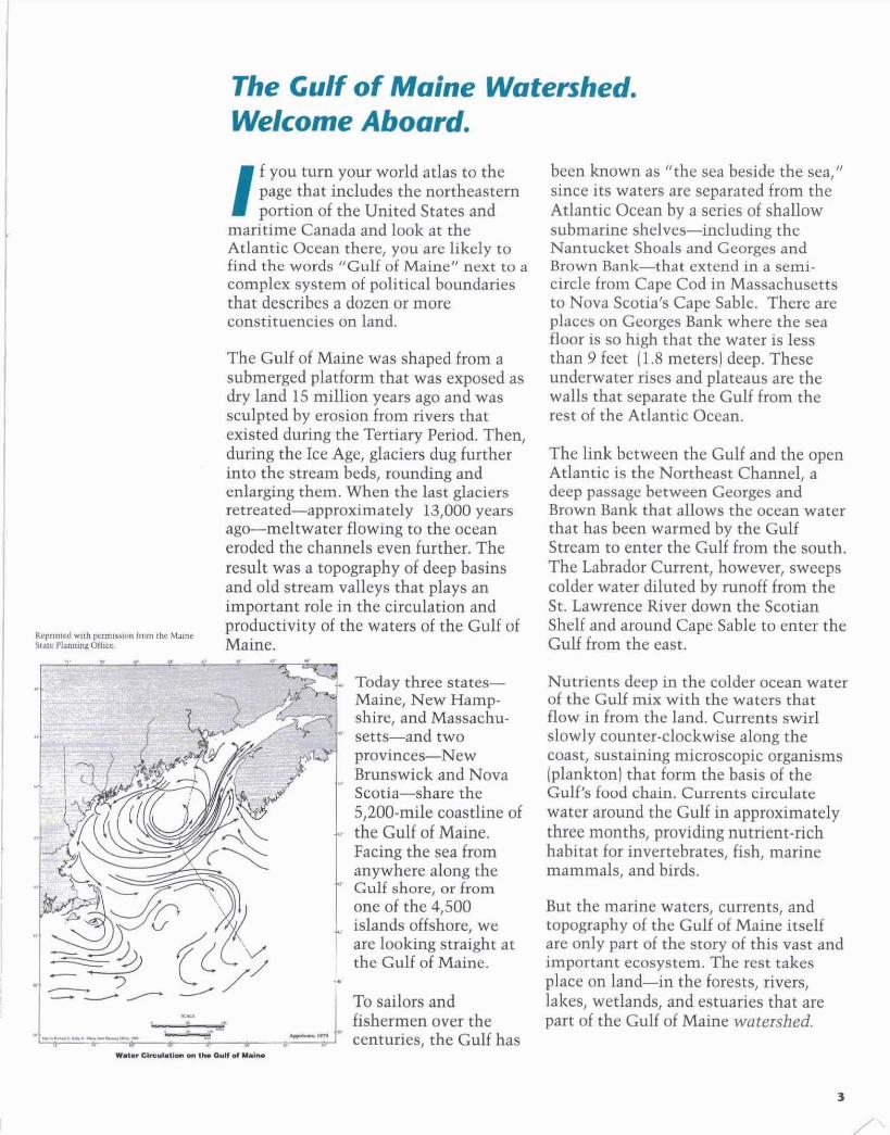
Nutrients deep in the colder ocean water of the Gulf mix with the waters that flow in from the land. Currents swirl slowly counter-clockwise along the coast, sustaining microscopic organisms (plankton) that form the basis of the Gulf's food chain. Currents circulate water around the Gulf in approximately three months, providing nutrient-rich habitat for invertebrates, fish, marine mammals, and birds.
But the marine waters, currents, and topography of the Gulf of Maine itself are only part of the story of this vast and important ecosystem. The rest takes place on land-in the forests, rivers, lakes, wetlands, and estuaries that are part of the Gulf of Maine watershed.
Wh@tLkrAmbhrdvdt The Gulf of Maine watershed is the area of land that collects all the water that flows into the Gulf. It extends over 69,000 square miles and includes such great river basins as the Memmack, Kennebec, hdroscoggin, Penobscot, and St. John.
Hundreds of miles away from the coast, every rivulet, creek, stream, and river within this huge area is part of its own local watershed and fits like a puzzle piece into the whole. Collectively, these watersheds provide terrestrial and aquatic habitat for a diversity of wildlife species, birds, and fish. Wetland habitats in the Gulf of Maine watershed make vital resting and feedmg grounds for migratory birds. In the watershed's upland streams, oxygen dissolves easily in the turbulent cold water, malung them favorable habitat for active swimmers like Atlantic salmon and brook trout.
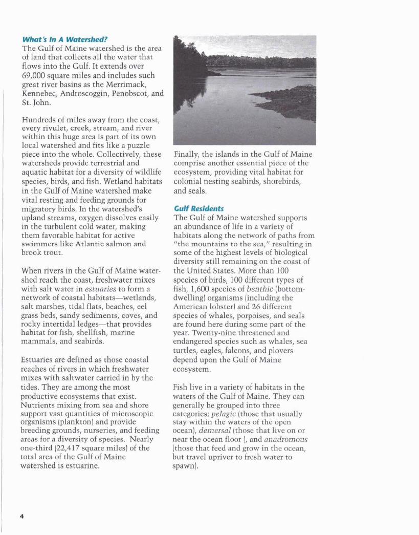
When rivers in the Gulf of Maine water- shed reach the coast, freshwater mixes with salt water in estuaries to form a network of coastal habitats--wetlands, salt marshes, tidal flats, beaches, eel grass beds, sandy sediments, coves, and rocky intertidal ledges-that provides habitat for fish, shellfish, marine mammals, and seabirds.
Estuaries are defined as those coastal reaches of rivers in which freshwater mixes with saltwater carried in by the tides. They are among the most productive ecosystems that exist. Nutrients mixing from sea and shore support vast quantities of microscopic organisms (plankton) and provide breedmg grounds, nurseries, and feeding areas foi a diversity of species. Nearly one-third (22,417 square miles] of the total area of the Gulf of Maine watershed is estuarine.
Finally, the islands in the Gulf of Maine comprise another essential piece of the ecosystem, providing vital habitat for colonial nesting seabirds, shorebirds, and seals.
wbM!ds The Gulf of Maine watershed supports an abundance of life in a variety of habitats along the network of paths from "the mountains to the sea," resulting in some of the highest levels of biological diversity still remaining on the coast of the United States. More than 100 species of birds, 100 different types of fish, 1,600 species of benthic (bottom- dwelhg] organisms (including the American lobster] and 26 different species of whales, porpoises, and seals are found here during some part of the year. ?tventy-nine threatened and endangered species such as whales, sea turtles, eagles, falcons, and plovers depend upon the Gulf of Maine ecosystem.
Fish live in a variety of habitats in the waters of the Gulf of Maine. They can generally be grouped into three categories: pelagic (those that usually stay within the waters of the open ocean), dernersal (those that live on or near the ocean floor 1, and anadromous (those that feed and grow in the ocean, but travel upriver to fresh water to spawn).
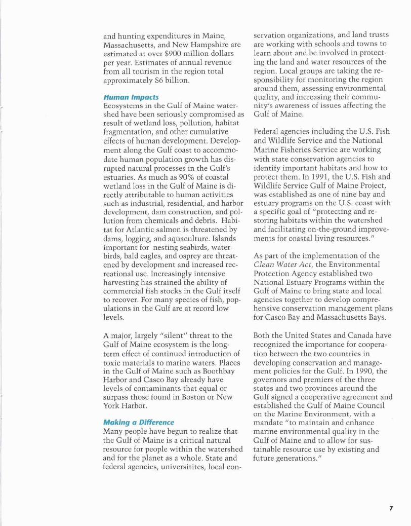
An estuary at work Repr~lted ~ 8 t h permianon horn the Mar"$ starc Plannlry: Oiilr.
Major groups of seabirds, shorebirds, and waterbirds in the Gulf of Maine include petrels, waterfowl, gulls, terns, alcids, herons, cormorants, and plovers. Some of these waterbirds, such as gulls and herons, are readily recognized and are currently abundant. Piping plovers, roseate terns, eagles, and falcons on the other hand, are so rare that they have been listed as threatened or endangered under the protection of the Endangered Species Act. The popular Atlantic puffin, a colonial nesting seabird, has- along with the lobster--become one of the region's most recognizable advertising symbols.
Marine mammals are present in greatest abundance in the Gulf of Maine during the summer months, when the seasonal upwelling and mixing of nutrients in the water provides the greatest supply of
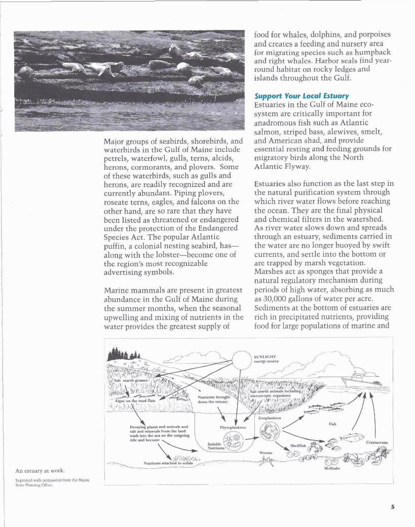
food for whales, dolphins, and porpoises and creates a feeding and nursery area for migrating species such as humpback and right whales. Harbor seals h d year- round habitat on rocky ledges and islands throughout the Gulf.
slpportv--W#r)r Estuaries in the Gulf of Maine eco- system are critically important for anadromous fish such as Atlantic salmon, striped bass, alewives, smelt, and American shad, and provide essential resting and feeding grounds for migratory birds along the North Atlantic Flyway.
Estuaries also function as the last step in the natural purification system through which river water flows before reaching the ocean. They are the final physical and chemical filters in the watershed. As river water slows down and spreads through an estuary, sediments carried in the water are no longer buoyed by swift currents, and settle into the bottom or are trapped by marsh vegetation. Marshes act as sponges that provide a natural regulatory mechanism during periods of high water, absorbing as much as 30,000 gallons of water per acre. Sediments at the bottom of estuaries are rich in precipitated nutrients, providing food for large populations of marine and

estuarine species such as worms, juve- nile fish, and shellfish. However, sedi- ments camed from land can also contain high concentrations of pollutants, which greatly decrease the productivity of shell. fish beds. Since sediments in the bottom tend to stay in one place, pollutants found there remain in the area much longer than pollutants in the water. Activities such as dredging in harbors stir up sediments and can reintroduce pollutants into the water itself.
UhdrrFlbvls- Given an average precipitation of about forty-four inches in the region annually, people estimate that about 250 billion gallons of water flow through estuaries and into the Gulf of ~ a i n e i v e r y year, carrying nutrients and sediments to the ocean. There is a direct relationship between the smallest rivulet high in the forests in northern Maine and New Brunswick and ocean water a hundred miles offshore in the center of the Gulf.
Runoff into the watershed's rivers is strongest and coldest during the spring months. The nutrients, sediments, and organic matter washed into the Gulf from the watershed are in great part responsible for the Gulf's remarkable level of productivity-it is among the most bioloericallv ~roductive marine areas in th; world: The interrelated nutrient and energy cycles, currents, and tides in the Gulf of Maine create a dynamic marine ecosystem that supports major fishing, tourist, and recreation industries.
Once the streams emerge from the mountains onto the floodplain, their de- scent to the Gulf is slowed. Runoff from agricultural and industrial activities on land often contributes excess nutrients and pollutants to the water, resulting in overgrowth of algae and weeds known as eutrophication, which decreases the amount of oxygen available in the water for other forms of aquatic life.
Most residential and commercial devel- opment is usually found further down- stream, where water is taken up by treatment plants to purify it for drinking and other household and industrial uses. If untreated, pollution from sewage, chemicals and waste can enter rivers at specific sites (in addition to non-point runoff from oils, wastes, and chemicals from roads, sidewalks, and other paved surfaces).
mmmlbhmts More than five million people live in the Gulf of Maine watershed. Contrary to the popular perception that the Gulf of Maine region is still largely a pristine and uncrowded landscape, it is the third most densely populated coastal region in the United States. By 2005, the human population in the coastal region from New Hampshire to southern Maine is expected to double from its 1985 levels.
Thousands of people depend on com- mercial fishing, shellfishing, aqua- culture, and related industries in the Gulf of Maine. There are over 13,500 licensed shellfish harvesters operating in Casco Bay alone, one of a dozen major embayments in the Gulf. Fisheries in the Gulf still arovide a harvest valued at more than $650 million every year, reflecting an annual catch of approxi- mately 1.2 billion pounds of fish. Tourism in the watershed supports another 200,000 jobs. Annual fishing
and hunting expenditures in Maine, Massachusetts, and New Hampshire are estimated at over $900 million dollars per year. Estimates of annual revenue from all tourism in the region total approximately $6 billion.
numan fmpats Ecosystems in the Gulf of Maine water- shed have been seriously compromised as result of wetland loss, pollution, habitat fragmentation, and other cumulative effects of human development. Develop- ment along the Gulf coast to accommo- date human population growth has dis- rupted natural processes in the Gulf's estuaries. As much as PO% of coastal wetland loss in the Gulf of Maine is di- rectly attributable to human activities such as industrial, residential, and harbor development, dam construction, and pol- lution from chemicals and debris. Habi- tat for Atlantic salmon is threatened by dams, logging, and aquaculture. Islands important for nesting seabirds, water- birds, bald eagles, and osprey are threat- ened by development and increased rec- reational use. Increasingly intensive harvesting has strained the ability of commercial fish stocks in the Gulf itself to recover. For many species of fish, pop- ulations in the Gulf are at record low levels.
A major, largely "silent" threat to the Gulf of Maine ecosystem is the long- term effect of continued introduction of toxic materials to marine waters. Places in the Gulf of Maine such as Boothbay Harbor and Casco Bay already have levels of contaminants that equal or surpass those found in Boston or New York Harbor.
-0- Many people have begun to realize that the Gulf of Maine is a critical natural resource for people within the watershed and for the planet as a whole. State and federal agencies, universitites, local con-
servation organizations, and land trusts are working with schools and towns to learn about and be involved in protect- ing the land and water resources of the region. Local groups are taking the re- sponsibility for monitoring the region around them, assessing environmental quality, and increasing their commu- nity's awareness of issues affecting the Gulf of Maine.
Federal agencies including the U.S. Fish and Wildlife Service and the National Marine Fisheries Service are working with state conservation agencies to identlfy important habitats and how to protect them. In 1991, the U.S. Fish and Wildlife Service Gulf of Maine Project, was established as one of nine bay and estuary programs on the U.S. coast with a specific goal of "protecting and re- storing habitats within the watershed and facilitating on-the-ground improve- ments far coastal living resources."
As part of the implementation of the Clem Water Act, the Environmental Protection Agency established two National Estuary Programs within the Gulf of Maine to bring state and local agencies together to develop wmpre- hensive conservation management plans for Casco Bay and Massachusetts Bays.
Both the United States and Canada have recognized the importance for coopera- tion between the two countries in developing conservation and manage- ment policies for the Gulf. In 1990, the governors and premiers of the three states and two provinces around the Gulf signed a cooperative agreement and established the Gulf of Maine Council on the Marine Environment, with a mandate "to maintain and enhance marine environmental quality in the Gulf of Maine and to allow for sus- tainable resource use by existing and future generations."
I ' The WIId Gulf Posters The tour psten that accompany this workbook can be used separately or together to frrdlkate learning about living resources and ecosystem prlnidples from a watershed-wide perspective.
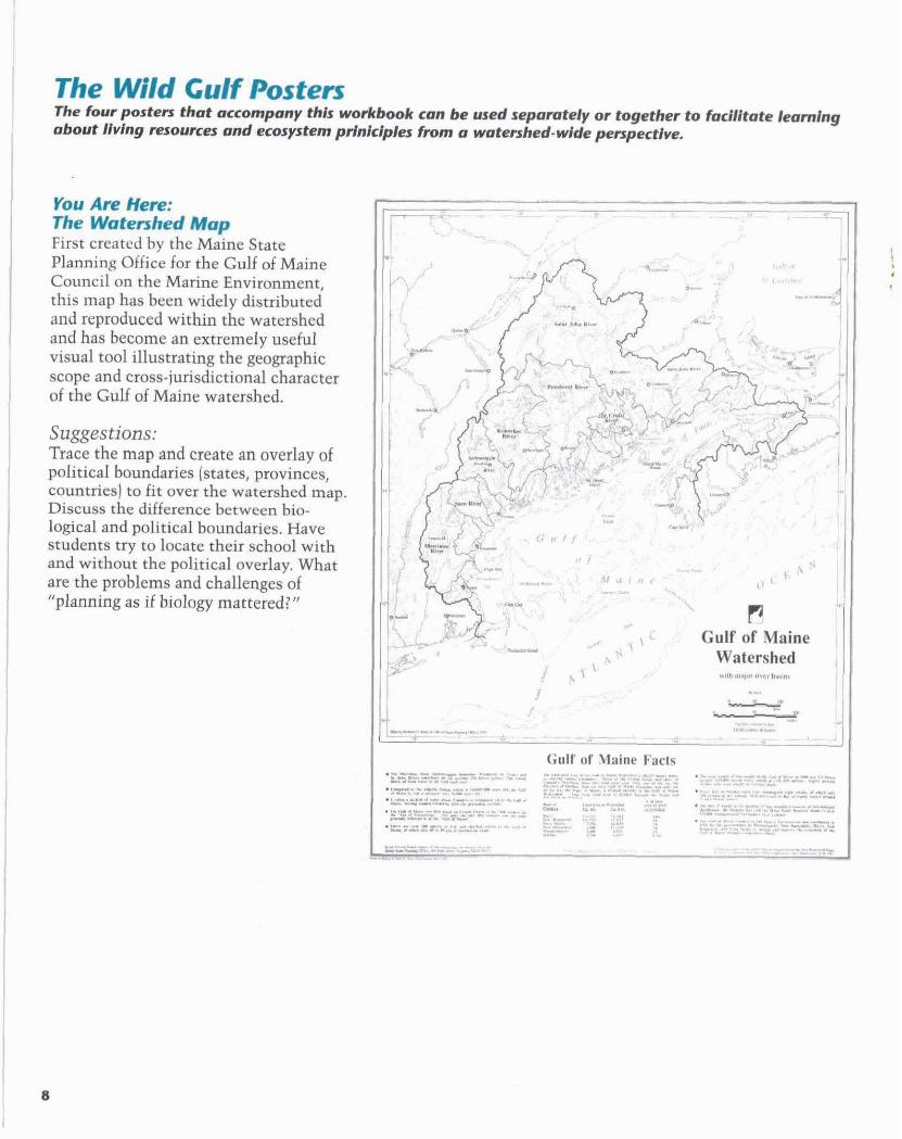
@u A k Hm: * watmhrd Mup First created by the Maine State Planning Office for the Gulf of Maine Council on the Marine Environment, this map has been widely distributed and reproduced within the watershed and has become an extremely useful visual tool illustrating the geographic scope and cross-jurisdictional character of the Gulf of Maine watershed.
Suggestions: Trace the map and create an overlay of political boundaries (states, provinces, countries) to fit over the watershed m g . Discuss the difference between bio- logical and political boundaries. Have students try to locate their school with and without the political overlay. What are the problems and challenges of "planning as if biology mattered? "
zZizd=' m: tmtlwkm
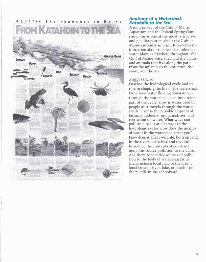
A joint project of the Gulf of Maine Aquarium and the Poland Spring Com- pany, this is one of the most attractive and popular posters about the Gulf of Maine currently in print. It provides in- formation about the essential role that water plays everywhere throughout the Gulf of Maine watershed and the plants and animals that live along the path from the uplands to the estuaries, the shore, and the sea.
Suggestions: Discuss the hydrological cycle and its role in shaping the life of the watershed. Note how water flowing downstream through the watershed is an important part of the cycle. How is water used by people as it travels through the water- shed? Discuss the possible impacts of farming, industry, municipalities, and recreation on water. What ways can pollution occur at all stages of the hydrologic cycle? How does the quality of water in the watershed affect you? How does it affect wildlife, both on land, in the rivers, estuaries; and the sea? Introduce the concepts of point and nonpoint source pollution to the class. Ask them to identify sources of pollu- tion to the body of water nearest to them, using a local map of the area (a local stream, river, lake, or beach-r the puddle in the schoolyard).
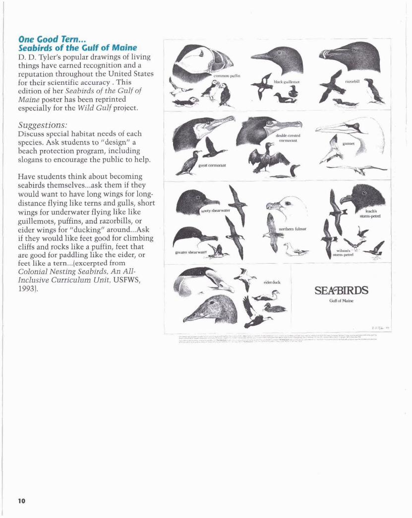
one Good Tan... Wdr of the Gulf d Maine D. D. vler's popular drawings of living rhmgs have earned recognition and a reputation throughout the United States for their scientific accuracy. This edition of her Seabirds of the Gulf of Maine poster has been reprinted especially for the Wild Gulf project.
Suggestions: Discuss special habitat needs of each species. Ask students to "design" a beach protection program, including slogans to encourage the public to help.
Have students think about becoming seabirds themselves ... ask them if they would want to have long wings for long- distance flying like terns and gulls, short wings for underwater flying like like guillemots, puffins, and razorbills, or
... eider wings for "ducking" around Ask if they would like feet good for climbing cliffs and rocks like a puffin, feet that are good for paddling like the eider, or feet like a tern ...( excerpted from Colonial Nesting Seabirds, An All- Inclusive Curriculum Unit, USFWS, 19931.
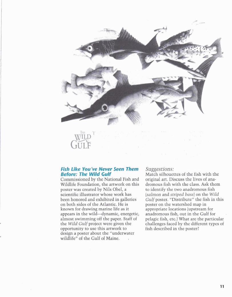
Bh Like rOuOw Nmrsem Than, brliorr: The Wild Gulf Commissioned by the National Fish and Wildlife Foundation, the artwork on this poster was created by Nils Obel, a scientific illustrator whose work has been honored and exhibited in galleries on both sides of the Atlantic. He is known for drawing marine life as it appears in the wild--dynamic, energetic, almost swimming off the paper. Staff of the Wild Gulf project were given the opportunity to use this artwork to design a poster about the "underwater wildlife" of the Gulf of Maine. .
Suggestions: Match silhouettes of the fish with the original art. Discuss the lives of ana- dromous fish with the class. Ask them to identify the two anadromous fish (salmon and striped bass) on the Wild Gulf poster. "Distribute" the fish in this poster on the watershed map in appropriate locations (upstream for anadromous fish, out in the Gulf for pelagic fish, etc.] What are the particular challenges faced by the different types of fish described in the poster?

fhe Wtld Gulf Almanac
TlwWIklGuHAlnm# k c a r l e C & c a t l o n r l ~ A i b o u t ElkCrrlfdMcdncwatenhd The Wild Gulf posters are only a small subset of the outstanding array of educational resources and materials available to teachers who want to bring "the Wild Gulf" into their classrooms. Many of these materials are available free of charge; others can be ordered at a discount in larger quantities; some are part of a whole curriculum package, some are available on loan, or as part of visiting lectures and programs that can come to your class for an hour or a week at a time. There are facilities, nature centers and exhibits, wildlife refuges, aquariums, fish hatcheries, and museums throughout the coastal region of the Gulf of Maine that are open to the public; many have special tours and programs for different grade levels.
The more educators in the Gulf of Maine become aware of each other's materials and resources, the more we can create an "educational watershed" of our own-combining strengths, pooling resources, identifying needs (both across the entire K-12 curriculum and for specific age groups), and sharing information and ideas for teachmg and learning about the Gulf of Maine ecosystem from a watershed perspective.
The Wild Gulf Almanac is a publication that catalogs and describes these resources and materials in one place, serving as a subject index and annotated directory to information about living resources in the Gulf of Maine. Each issue of the Almanac will build on the previous one, and cumulatively, will provide a comprehensive description of educational materials available about the watershed organized along a series of ecological and environmental themes.
Some examples from the first issue of the Almanac:
TOPIC
&tuarler/&stuarfne Ecology T ITLE
DEPTHS: Discovering Ecology, Pathway to Science TARGET GROUP
Curriculum f i r Gmdes K-6 DEVELOPED I IY A N D AVAILABLE PROM
The Wells National Estuarine Research Reserve. (207) 646- 1555 The DEPTHS program focuses on estuaries as an introduction to ecology. It has been successfully piloted in schools around Maine and New Hampshire for several years, and is currently undergoing final revisions. The program is a week-long curriculum for grades K-4. Teacher workshops for participating schools are led by the Wells Reserve as part of the program to illustrate use of materials. Estuarine Ecology: An Introduction to Ecology accompanies the materials and provides the necessarv backrrround information.
Activities for each grade are based on a theme, which aids students in viewing the estuary:
GradeK Patterns Grade 1 Similarities and
Differences Grade 2 Relationships Grade3 Change Grade 4 Communities Grade 5 Global Perspectives Grade 6 Adaptations--(a month-
long curriculum)
Each unit has activities that integrate life science, earth science, and physical science.
For all grades the first activity in the program teaches examples of the theme that the students are familiar with in their own world. The kindergarten describes patterns found at home, while the fifth grade studies where water comes from, how it is used, and where it goes. The second activity draws on the
conclusions students reach about patterns, relationships, change, etc., in their own experiences and transfers the ideas to the setting of the estuary. Then the kindergarten makes an estuary pattern, describing a plant, animal, and soil type for each part of the pattern. Meanwhile, the fifth grade is introduced to the idea of a watershed. Students are asked to define a watershed, describe its important features, and locate their own town within their watershed. Subsequent lessons build upon the established themes, while teaching about different aspects within the estuary such as its flora, fauna, the types of soil and the effect of being in a tidal zone. Each activity has a clearly stated objective as well as estimated completion times. The Wells Reserve provides all the necessary material for performing the activities. After a school has used the curriculum, the Reserve holds workshops to assess the program's effectiveness.
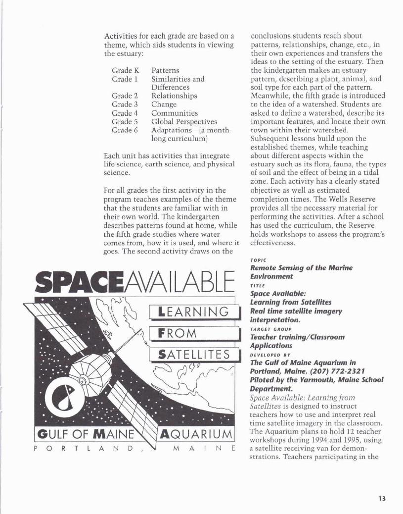
Remote Sensing of the Marlne -AVAILABLE :tmmt L- Space AvaIIable:
learning f h m SatdIltcs R e d tlme satellite lmage~y inteqmtation. rrlRcEr CROUP
Tbacher tminlng/Ciassmm Applications DEVELOPED BY
The Gulf of Maine Aquarium in hrtiand, Maine. (207) 772-2321 Piloted by the Yannouth, Maine School Department. Space Available: Learning from Satellites is designed to insmct teachers how to use and interpret real time satellite imagery in the classroom. The Aquarium plans to hold 12 teacher workshops during 1994 and 1995, using a satellite receiving van for demon- strations. Teachers participating in the

workshops will then be able to use the receiving van in the classroom. Also under development is a teacher hand- book, which will contain background information and reproducible classroom handouts and activity suggestions. This guide describes the acquisition and use of satellite imagery in the classroom. Examples of some of the proposed activities are:
Snow Melt/Hydrologic Cycle. Automatic Picture Transmission (APT) is used to monitor and chart ice breakup in Hudson Bay. Snowmelt is used to initiate discussion about the hydrologic cycle as shown in the Katahdin to the Sen poster that is part of the Wild Gulf poster series.
Where is the Space Shuttle? During shuttle missions, student may use satell- ite-tracking software to project and vis- ually sight the shuttle's next pass over the Gulf of Maine, or across various con- stellations. They can also locate and vis- ually sight the Russian space station Mir.
Where Am I? Students will use a global positioning system (GPS) receiver to overlay their current position to a street map. Students will study the history and methods of navigation to learn how to fix their position when they cannot tell by looking out the window.
Tracking Sea Turtles Students will re- ceive, via satellite transmission modem, primary data that identifies the current location of 10 Kemps Ridley sea turtles, the ratio of time spent above and below the surface, and the water temperature.
Ocean Current Temperature Monitoring. Satellite imagery showing highlighted temperature gradients will enable students to locate currents in the Gulf of Maine and discuss oceanography and marine biology.
Oil Spill. Students are given a scenario in which an oil tanker has hit a submerged ledge in the Gulf of Maine and is leaking crude oil. The tanker's position, wind speed, and wind direction are also pro- vided. Discussion follows about where and when the oil will hit the coast, impact of the spill on coastal living resources, and response mechanisms that are currently in place to protect against or mitigate such occurrences.
T O P I C
Gulf of Maine Fisheries Issues. T I T L E
Taking Stock of Our Fisheries. TAi7GET G R O U P
High School D E V E L O P E D B I
Manomet Observatory for Conservation Sciences. (508) 224-6521 Piloted In Gloucester, Boston, New Bedford, and Mymouth, Massachusetts Taking Stock of Our Fisheries (TSF) is a program that concentrates on the issues surrounding the groundfish populations of the Gulf. These fish (haddock, cod, flounder, etc.) have been major contributors to New England's economy, but their numbers have decreased dramatically in the past 20 years as a result of overfishing and resource mismanagement.

One component of TSF is a Teacher Resource Guide for high schools throughout the Gulf of Maine. Its goals are 1) to assist high schoolinstructors to each about the Gulf of Maine fisheries issues 2) to improve students' awareness of fisheries resources and their associated marine habitats 3) to build a support network for classes on a regional scale.
TOPIC
Gulf of Maine Fisheries Issues. TITLE
FishNET: Fisheries Conservation Education Network. TARGCT GROUP
Rcbitc Outreosh/Communlty Education D E V E L O P l D B Y
Atlantic Center for the Environment (508) 356-0038 Community-based marine science and education program in the Gulf of Maine Region. Activities include development of interdisciplinary marine science programs for elementary and secondary schools, science literacy outreach and mentoring programs, technical assistance for community development organizations, and creation of a binational network of professionals working on fisheries-related issues.
stay rimed... The first issue of the Wild Gulf Almanac will be published in the fall of 1994. As the first publication of its kind in the watershed it will, of necessity, be a "work in progress." Your interest and help in reviewing and using the first Almanac will be essential in making the next issue larger, more accurate, and more comprehensive than the first.
We realize at the outset that materials and directories often become dated even before they appear in print. Even more importantly, as new materials are developed and our network of commnni- cation grows about the resources that already exist, there will always be a need for another, better, updated edition.
Please help us make the Wild Gulf Almanac series a resource you will want to turn to and use again and again. If you would like to be on the Wild Gulf mailing list, contact the Wild Gulf Project at the Chewonki Foundation (207) 882-7323.

The C h c w d Foonbtion RR2 Box 1200, Wiscasset,
Maine 04578 (207) 882-7323
U S P l r k & ~ ~ ~ a l f of mdw W M
4R Fundy Road, Falmouth, Maine 04105
(207) 781-8364
WctlrNuioulE.tard*c LcwrhBcemc
P.O. Box 1007, Wells, Maine 04090.9988
(207) 646-1555
~~ ~~ ~ . ~~ ~~ ~ ~ ~ ~~ ~~ ~ ~~ ~. ~~ - ~ ~~~~ ~ ~~~~~~~~~~ -~
~ e k u e h Ram& Fvndfng for tbrprolect includes mppon horn the Nathnal ~ i r h o n d ~ ~ d h f ~ ~ & n d a t i o n , l h a ~ u l f o f ~ o i i &wci on the Marin# ~nnrnnm6.t . rhs Collohotim of Cammwtlty Poundatfans fca the CuUof MauM Ennronmant. BankAmsriu Fwndoaon. Brvr P l o Shops. Maine Yonksr. tha Hemy 6. Plnnt