1 global positioning system (gps) trenton computer festival 2007
TRANSCRIPT
1
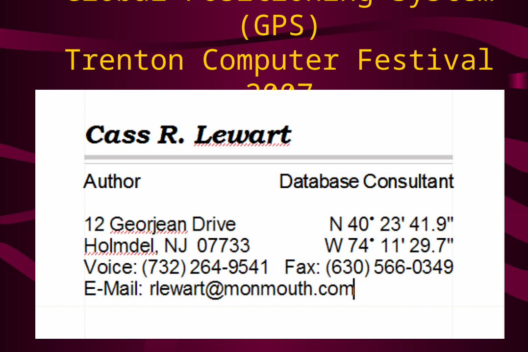
Global Positioning System (GPS)Trenton Computer Festival 2007

GPS TCF Presentation 2007
Cass Lewart © 2000 - 2007
2
GPS Haiku
• In ultimate cold through solar wind you orbit, to warmth you guide me
• Wife says pull over, no clear view of satellites, ask for directions
• Batteries are toast, map compass reading not learned, I await searchers

GPS TCF Presentation 2007
Cass Lewart © 2000 - 2007
3
Basic GPS Design
• GPS (DoD) with 24 active satellites, Glonass (Russian Federation) with only 11 active satellites, European Galileo (planning stage)
• GPS: Space Segment: 24 satellites + 4 spares in 12 hour, 20,100 km, 55º orbits, four satellites in each of the six orbital planes Control Segment: Ground stations adjust satellite clocks, provide
orbital parameters (almanac, ephemeris) for each satelliteUser Segment: GPS receivers provide navigational and time
information. Strength of the received signal is only 1 billionth of a TV signal

GPS TCF Presentation 2007
Cass Lewart © 2000 - 2007
4
GPS Satellite Orbits

GPS TCF Presentation 2007
Cass Lewart © 2000 - 2007
5
Operating Modes
• Precise Positioning System (PPS) - US and allied military, authorized government agencies - 22 m horizontal, 27.7 m vertical, 100 ns accuracy (95% of time). Resistant to jamming (L1/L2)
• Standard Positioning System (SPS) - civilian use - 100 m horizontal, 156 m vertical, 340 ns accuracy with S/A, improved to nearly PPS values after May 1 2000 but with no resistance to jamming
GPS TCF Presentation 2007
Cass Lewart © 2000 - 2007
6
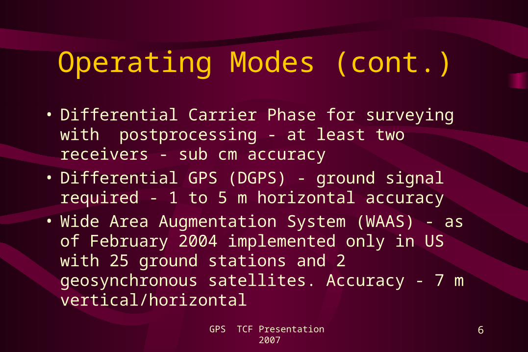
Operating Modes (cont.)
• Differential Carrier Phase for surveying with postprocessing - at least two receivers - sub cm accuracy
• Differential GPS (DGPS) - ground signal required - 1 to 5 m horizontal accuracy
• Wide Area Augmentation System (WAAS) - as of February 2004 implemented only in US with 25 ground stations and 2 geosynchronous satellites. Accuracy - 7 m vertical/horizontal

GPS TCF Presentation 2007
Cass Lewart © 2000 - 2007
7
Determining Position on the Globe
• Almanac (status and clock information), ephemeris (orbital information) are broadcast to GPS receivers at same frequencies for each satellite (1.2 and 1.5 GHz, 20 - 25 cm)
• . Different ID codes used by each satellite - Timing information is based on satellite clocks
• Cesium/rubidium clocks - 1 sec in 300 years• Triangulation by adjusting receiver clock: 1 s = 300
meters.

GPS TCF Presentation 2007
Cass Lewart © 2000 - 2007
8
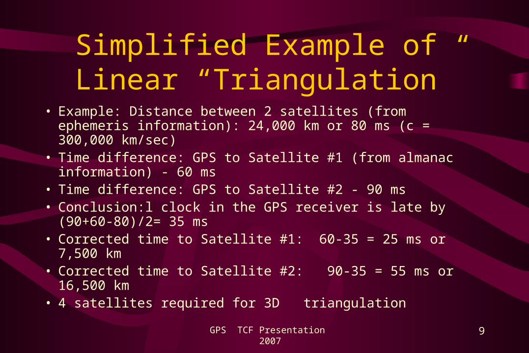
Simplified Example of Linear “Triangulation”
GPS TCF Presentation 2007
Cass Lewart © 2000 - 2007
9
Simplified Example of Linear “Triangulation”
• Example: Distance between 2 satellites (from ephemeris information): 24,000 km or 80 ms (c = 300,000 km/sec)
• Time difference: GPS to Satellite #1 (from almanac information) - 60 ms
• Time difference: GPS to Satellite #2 - 90 ms• Conclusion:l clock in the GPS receiver is late by
(90+60-80)/2= 35 ms• Corrected time to Satellite #1: 60-35 = 25 ms or 7,500 km• Corrected time to Satellite #2: 90-35 = 55 ms or 16,500 km• 4 satellites required for 3D triangulation

GPS TCF Presentation 2007
Cass Lewart © 2000 - 2007
10
Sources of Error
• Code noise, receiver noise, satellite clock - 1 m each• Ephemeris data error, troposphere delay - 1 m each• Unmodeled ionosphere delay - 10 m , multipath - 1 m• Satellite constellation geometry - 10 m• S/A (RIP) reduced horizontal accuracy from 22 to 100 m
(95% of time). S/A was introduced in 1980 and discontinued at midnight on May 1, 2000 by order of president Bill Clinton
• Human and software errors can make GPS useless

GPS TCF Presentation 2007
Cass Lewart © 2000 - 2007
11
GPS and Relativity Theory
• Special Relativity (SR): Clocks affected by satellite speed relative to earth frame of reference
• General Relativity (GR): Clocks affected by differences in gravitational field between satellites and receivers
• SR effects compensated by adjusting satellite clock divider ratios - different ratio for rubidium/cesium clocks on satellites and on earth
• A 48 page paper describing effects of relativity: http://arxiv.org/PS_cache/gr-qc/pdf/0306/0306076.pdf

GPS TCF Presentation 2007
Cass Lewart © 2000 - 2007
12
Derived Navigational Information
• Lat/Lon in degrees, UTM, and in other units • Local time, UTC, elapsed time, ETA, ETE,
altitude• Speed, heading, bearing (true or magnetic) all in
land or marine terms (SPD/SOG, HDG/COG, VMG, Landmarks/Waypoints, etc.)
• Distance to destination, distance traveled• “Bread crumb” trail

GPS TCF Presentation 2007
Cass Lewart © 2000 - 2007
13
Types and Cost of GPS Receivers
• Hand-held, “watch”, car and boat mounted, PDA attachments ($100 - $800)
• Built into cars (OEM) with voice guidance, maps, street and address software with road lock, inertial navigation and DGPS ($1,000 - $3,000)
• For land surveys with Carrier Phase Comparison and post processing ($5,000 - $20,000)
• Military with PPS and S/A decryption ($???)

GPS TCF Presentation 2007
Cass Lewart © 2000 - 2007
14
Features in $100 - $800 Price Range
• Small manufacturers - Garmin, Magellan, Lawrence• Marketing decides on feature sets and models• Not much advertising - little awareness, except by boat
owners hikers, and drivers (only recently)• Storing of waypoints, routes and tracks• 8 - 15 display screens with context sensitive menus• Color display, back light• Depending on price range - user waypoints, city waypoints,
fixed maps, maps on cartridges, maps downloadable from CDs, door-to-door voice directions

GPS TCF Presentation 2007
Cass Lewart © 2000 - 2007
15
Additional Features in $100 - $800 Price Range
• Parallel input for up to 18 satellites vs. multiplexed input• Selection of map datums, coordinate systems• Simulation mode• 100 - 1000 waypoints• 10 - 50 routes with back tracking, MOB• Sun/Moon rise and set, moon phase, dynamic display• Wide range of scales on map display (0.1 - 1,000 mi)• Proximity and other alarms

GPS TCF Presentation 2007
Cass Lewart © 2000 - 2007
16
Portable GPS Receivers ($100 - $300)

GPS TCF Presentation 2007
Cass Lewart © 2000 - 2007
17
Portable GPS Receivers (cont.)
Etrex Summit, with electronic
digital compass, barometer
and altimeter, but as reported
by many users has poor
sensitivity

GPS TCF Presentation 2007
Cass Lewart © 2000 - 2007
18
Car Mounted GPS Receivers ($350 - $800)
• Magellan 2200T
• Touch Screen
• Door to Door guidance
• Voice output

GPS TCF Presentation 2007
Cass Lewart © 2000 - 2007
19
Integrated Pocket PC/GPS
Mitac Mio 168
Full featured Pocket PC
With integrated GPS
Main problem: after 4 hours
of operation needs recharging

GPS TCF Presentation 2007
Cass Lewart © 2000 - 2007
20
Military Units
• Plugger and 2 competing designs

GPS TCF Presentation 2007
Cass Lewart © 2000 - 2007
21
Satellite Status
• 5,300 mi. horizon

GPS TCF Presentation 2007
Cass Lewart © 2000 - 2007
22
Compass Rose

GPS TCF Presentation 2007
Cass Lewart © 2000 - 2007
23
GoTo Large Screen
GPS TCF Presentation 2007
Cass Lewart © 2000 - 2007
24
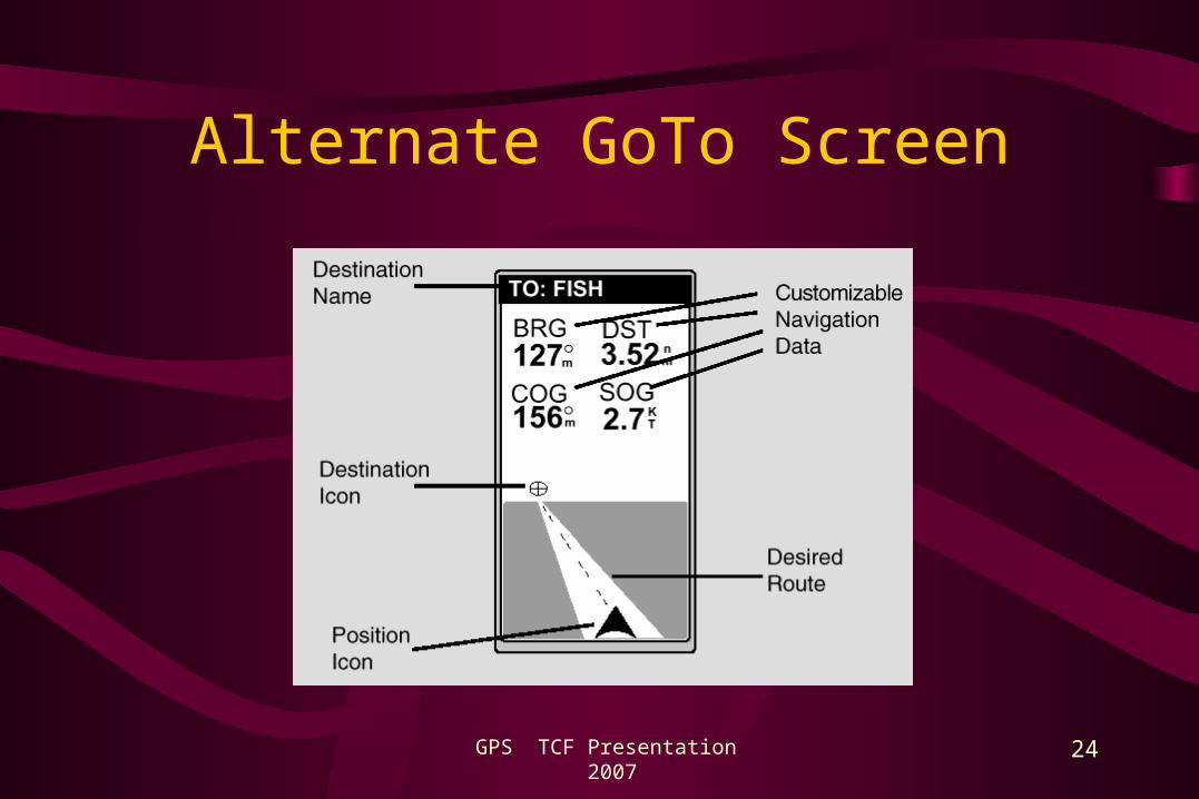
Alternate GoTo Screen

GPS TCF Presentation 2007
Cass Lewart © 2000 - 2007
25
Graphical Position Display(Without Map Capability)

GPS TCF Presentation 2007
Cass Lewart © 2000 - 2007
26
Graphical Position Display (With Map Capability)
• B/W and Color Map Displays

GPS TCF Presentation 2007
Cass Lewart © 2000 - 2007
27
Map Display in Magellan 360

GPS TCF Presentation 2007
Cass Lewart © 2000 - 2007
28
Graphical Position Display With Map Capability
New York City, Central Park

GPS TCF Presentation 2007
Cass Lewart © 2000 - 2007
29
Tachometer/Odometer Screen

GPS TCF Presentation 2007
Cass Lewart © 2000 - 2007
30
Time Screen
.

GPS TCF Presentation 2007
Cass Lewart © 2000 - 2007
31
Flash Memory Usage
• Example - Magellan SporTrak Pro - 32 Mbytes reserved for base and detailed maps, waypoints, routes and tracks
• Installation of detailed maps only possible with proprietary protocols and specific (and expensive) manufacturer’s software, though there are some “hacks”
• Basemaps are factory installed but there are ways for uploading and downloading them on some units
• Access to user data (waypoints, routes, tracks, current position) available with most commercial software

GPS TCF Presentation 2007
Cass Lewart © 2000 - 2007
32
Hiking and Driving with a GPS
• Heading - direction of travel, Bearing - direction to a waypoint (in degrees)
• Using a compass, compass rose on GPS (>5 mi/h speed required for accurate heading indication), dynamic Sun/Moon display
• Making turns when Bearing and Heading differ by, e.g., 90 deg or TURN = 90 deg
• Marking trail head and trail crossings
• Horizontal accuracy - 100 ft or better (after 05/01/00).

GPS TCF Presentation 2007
Cass Lewart © 2000 - 2007
33
Compass Use when Hiking
• Set Compass to “Bearing”
• K&R Meridian PRO
• Prismatic vs. Lensatic Compass
• Precision within 1-2 degrees
• Protection from Eddy Currents

GPS TCF Presentation 2007
Cass Lewart © 2000 - 2007
34
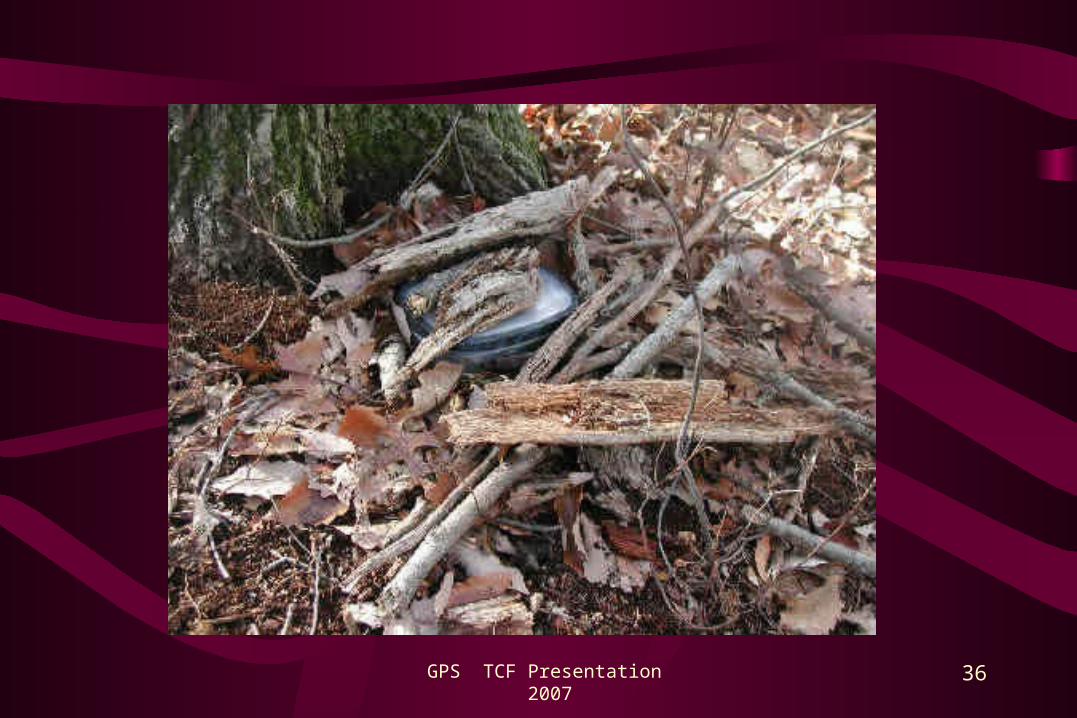
Geocaching
• A new world wide sport requires a GPS and a compass
• Coordinates with a short description
• Hints – such as “Think of Marx Brothers Movies”
• One cache may lead to another one
• http://www.geocaching.com/

GPS TCF Presentation 2007
Cass Lewart © 2000 - 2007
35
GPS TCF Presentation 2007
Cass Lewart © 2000 - 2007
36

GPS TCF Presentation 2007
Cass Lewart © 2000 - 2007
37
Transferring a Hike to a Topo Map
• Uploading tracks to a mapping program, e.g., to TOPO USA on the PC (Huber Woods, NJ)

GPS TCF Presentation 2007
Cass Lewart © 2000 - 2007
38
GPS On A Commercial Flight
• Hold against window - a great sensitivity test• Know where you are, also speed, altitude• Flight attendant: “Please put it away”• Captain: “You can use it, provided you tell us if
we are going off-course.”• Check if allowed by airline (subject to pilot
discretion): http://gpsinformation.net/airgps/airgps.htm
GPS TCF Presentation 2007
Cass Lewart © 2000 - 2007
39
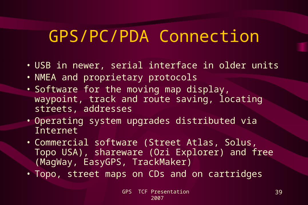
GPS/PC/PDA Connection
• USB in newer, serial interface in older units• NMEA and proprietary protocols• Software for the moving map display, waypoint, track
and route saving, locating streets, addresses• Operating system upgrades distributed via Internet• Commercial software (Street Atlas, Solus, Topo USA),
shareware (Ozi Explorer) and free (MagWay, EasyGPS, TrackMaker)
• Topo, street maps on CDs and on cartridges

GPS TCF Presentation 2007
Cass Lewart © 2000 - 2007
40
GPS on the Web
• General links - http://gpsinformation.net • Usenet - sci.geo.satellite-nav• Yahoo news groups for specific models• US address search - http://www.mapsonus.com (don’t
forget to convert to your current format, e.g., ddd.dddd to ddd.mm.ss or vice versa!). Also programs such as MS Streets &Trips or DeLorme Street Atlas
• Manufacturer and vendor web pages

GPS TCF Presentation 2007
Cass Lewart © 2000 - 2007
41
Power Sources
• 2 - 6 mostly AA batteries, 100 - 200 mA drain• Primary - Alkaline (2,000 mAh), Lithium (2,500 mAh)• Rechargeable - NiMH (1,500 -2,200 mAh). Manufacturer
specs not reliable• Factors for selection - battery capacity, temperature
dependence, weight and price • Cigarette lighter cable with voltage regulator (10-14V
converted to a specific GPS voltage)

GPS TCF Presentation 2007
Cass Lewart © 2000 - 2007
42
Where Do We Go From Here
• New generation Block 3 satellites. Higher power (2,000W instead of current 500W) with additional frequencies L3 through L5 will replace current Block 2 satellites - 18 out of 24 are past their design limits
• Use in civil aviation• Expanded use by emergency services in conjunction with
cellular networks (911, OnStar, Sprint Family Locator)• Privacy concerns (1984)• Expanded military use (cruise missiles, precision
munitions, drones)

GPS TCF Presentation 2007
Cass Lewart © 2000 - 2007
43
Current Trends
• Paid subscription to map updates
• High prices for maps
• Emphasis on more expensive car units for door-to-door navigation
• Converting a one time sale to a steady revenue stream

GPS TCF Presentation 2007
Cass Lewart © 2000 - 2007
44
Brookdale Computer User Group (BCUG)
• Group of 300+ volunteers interested in computers
• BCUG is is an independent non-profit organization not associated with Brookdale Community College
• Monthly general meetings at Brookdale Community College campus in Lincroft, NJ, monthly newsletter
• Currently 18 special interest groups meet monthly at various locations
• Dues are $25/year, $20 for non-working retirees
• For more information: www.bcug.com