1 fourmile brochure inside 5.13.13 final brochure map 2013.pdf · n whipple trail 6030a broken...
TRANSCRIPT
Buena Vista
Johnson Village
to Fairplay
to Hartsel
to Salida
to Leadville
to Salida15.8 miles
first 6.5 miles open to unlicensed OHVs
315
305
376
376
376A
376B
1450ACR307
CR187
308
CR309
311311
309
311
373
375
375
377
329
329318
309
188
300
300
CR300
185 186
1435
1434
618617
1415
1414
375D
375B
375A375E
375AA
373A
311E
311D
311B
376G
376AC376AB
329A
308B2
308B 308H
308C308
188A
185E
185D
300A
300B1
300C
1434A
1424
14251423
188
185B
185C1
185C
Elk1Elk2
Elk3
184
300
CR301
CR371
6043
Chinaman Gulch Loopadvanced
6044
6042Carnage Canyon
308A
6029
6037
311F375C
376D
376I
309A
311A
315A
315C
315B
315D
CR304
N Whipple Trail6030A
Broken Boyfriend Trail6032A advanced
Whipple Trail6031
Midland Hill Trail6032B
South Loop Trail6032
N Colorado
185
1450Midland Bike Trail
CR371
6039
6038
1425
1423
6034
186
CR306
376AA
1423A
1413Davis Meadow Trail
advanced
6034ACR303
CR187
CR187
CR305
CR304
307
Bald Mtn Loopadvanced
300Bextreme
Park CR86
CR375
Windmill Dr
Turret Trail6045
6033
Turret Trail6045
Catkin Gulch Loop6046
6045A
6045BBrowns Canyon
Wilderness Study Area
BLMno motorized or mechanized
travel permitted
Buffalo PeaksWilderness
AreaUSFS
no motorized or mechanized travel permitted
Ruby Mtn CG
Davis Meadow
Triad Ridge
Arkansas River
Arnold G
ulch
Bald M
tn Gulc
h
Bassam Park
McGee Gulch
Aspen Ridge
Sevenm
ile Cree
k
Fourmile Creek
Mushroo
m Gulch
Shields Gulch
Lenhardy Cut-off
Railroad Bridge
CG
Kaufman Ridge
W Buffalo Peak13,326’
E Buffalo Peak13,300’
The Castles
Trout Creek
Castle Rock Gulch
Chubb Park State Trust/
Wildlife Management
Area
Fisherman’s Bridge
Kaufman Pasture
Ruby Mtn
Elk Mtn
Spanish Mill
Chubb Park
Arch
Castle Rock
Collegiate Peaks Overlook
E Main
Arkansas River
Turtle Rock Camp Spur
MidlandRR Tunnels
Arkansas River
ElephantRock
ClimbingArea
Bob’s RockClimbingArea
SailorHomestead
closed tounlicensed vehicles
between CR371and trailhead
nounlicensed
vehiclehighwaycrossing
nounlicensed
vehiclehighwaycrossing
Limestone Ridge
nounlicensed
vehiclehighwaycrossing
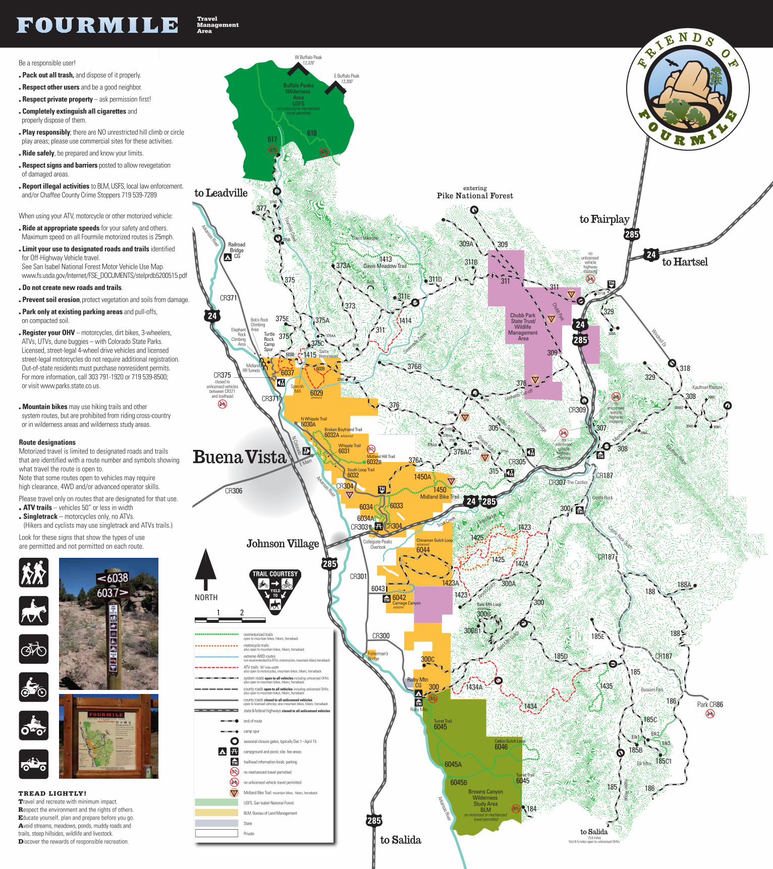
nonmotorized trails open to mountain bikes, hikers, horseback
motorcycle trails also open to mountain bikes, hikers, horseback
extreme 4WD routes not recommended for ATVs, motorcycles, mountain bikes, horseback
ATV trails 50” max width also open to motorcycles, mountain bikes, hikers, horseback
system roads open to all vehicles including unlicensed OHVsalso open to mountain bikes, hikers, horseback
county roads open to all vehicles including unlicensed OHVs; also open to mountain bikes, hikers, horseback
county roads closed to all unlicensed vehicles open to licensed vehicles; also mountain bikes, hikers, horseback
state & federal highways closed to all unlicensed vehicles
end of route
camp spur
seasonal closure gates, typically Dec 1 – April 15
campground and picnic site: fee areas
trailhead information kiosk, parking
no mechanized travel permitted
no unlicensed vehicle travel permitted
Midland Bike Trail: mountain bikes, hikers, horseback
USFS, San Isabel National Forest
BLM, Bureau of Land Management
State
Private
TREAD LIGHTLY!Travel and recreate with minimum impact.Respect the environment and the rights of others.Educate yourself, plan and prepare before you go.Avoid streams, meadows, ponds, muddy roads and trails, steep hillsides, wildlife and livestock.Discover the rewards of responsible recreation.
Be a responsible user!
. Pack out all trash, and dispose of it properly.
. Respect other users and be a good neighbor.
. Respect private property – ask permission first!
. Completely extinguish all cigarettes and properly dispose of them.
. Play responsibly; there are NO unrestricted hill climb or circle play areas; please use commercial sites for these activities.
. Ride safely, be prepared and know your limits.
. Respect signs and barriers posted to allow revegetation of damaged areas.
. Report illegal activities to BLM, USFS, local law enforcement. and/or Chaffee County Crime Stoppers 719 539-7289
When using your ATV, motorcycle or other motorized vehicle:
. Ride at appropriate speeds for your safety and others. Maximum speed on all Fourmile motorized routes is 25mph.
. Limit your use to designated roads and trails identified for Off-Highway Vehicle travel. See San Isabel National Forest Motor Vehicle Use Map. www.fs.usda.gov/Internet/FSE_DOCUMENTS/stelprdb5200515.pdf
. Do not create new roads and trails.
. Prevent soil erosion, protect vegetation and soils from damage.
. Park only at existing parking areas and pull-offs, on compacted soil.
. Register your OHV – motorcycles, dirt bikes, 3-wheelers, ATVs, UTVs, dune buggies – with Colorado State Parks. Licensed, street-legal 4-wheel drive vehicles and licensed street-legal motorcycles do not require additional registration. Out-of-state residents must purchase nonresident permits. For more information, call 303 791-1920 or 719 539-8500; or visit www.parks.state.co.us.
. Mountain bikes may use hiking trails and other system routes, but are prohibited from riding cross-country or in wilderness areas and wilderness study areas.
Route designationsMotorized travel is limited to designated roads and trails that are identified with a route number and symbols showing what travel the route is open to. Note that some routes open to vehicles may require high clearance, 4WD and/or advanced operator skills.
Please travel only on routes that are designated for that use.. ATV trails – vehicles 50” or less in width . Singletrack – motorcycles only, no ATVs. (Hikers and cyclists may use singletrack and ATVs trails.)
Look for these signs that show the types of use are permitted and not permitted on each route.
TravelManagement Area