1 conceptual models (cms): cold air cloudiness (cac), enhanced cumulus (ec ) and comma how to use...
TRANSCRIPT

1
Conceptual Models (CMs):Cold Air Cloudiness (CAC),
Enhanced Cumulus (EC)
and Comma
How to use MSG satellite images
similarities to and improvements
over MTP
Contact person:Veronika [email protected] 1.0. 13 July 2004
2
CMs:CAC, EC and Comma
(Cold Air Cloudiness and Enhanced Cumulus)
• MTP channels in comparison with the corresponding MSG channels
• CMs: CAC+EC: IR image + relevant NWP parameters
• MSG additional channels + Channel combinations

3
MTP: ir
CAC
EC
Co
As the image time between MTP and MSG differs, a shift between the cloud systems can be noticed in the two images
4
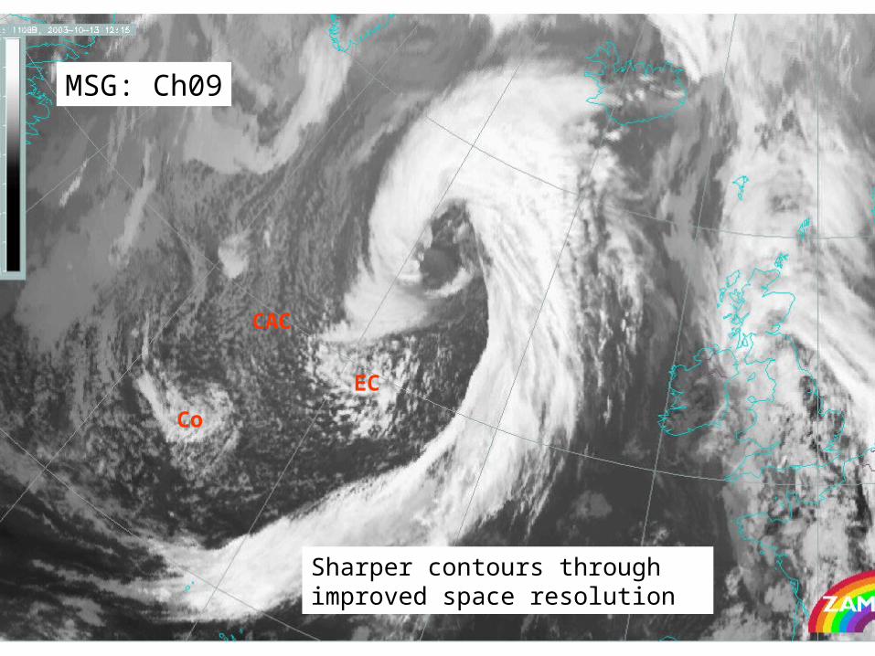
MSG: Ch09
Sharper contours throughimproved space resolution
CAC
EC
Co

5
MSG: Ch10
Visual inspection shows only very slight changes between Ch09 and Ch10;quantitative evaluation necessary
CAC
EC
Co

6
MTP: vis
CAC
EC
Co

7
Looks relatively similar;but: somewhat coarser space resolution MSG: Ch01
Grey clouds representtransperent clouds
CAC
EC
Co

8
MSG: Ch02
Compared to Ch01:no strong differences in the cloudfeatures over the ocean;but: much better land recognition
Visibility of transperentclouds worse thanin Ch01
CAC
EC
Co

9
MTP:VIS(2x)+IR
Blue: high cloudis very dominant
CAC
EC
Co

10
MSG:129
Sharper contours and more detailed grey-shadesthrough improved space resolution in IR and additional information from 2 different VIS channels
Dark blue: High cloudlight blue: thick cellsyellow: less thick cloud cells
CAC
EC
Co

11
CMs:CAC, EC and Comma
(Cold Air Cloudiness and Enhanced Cumulus)
• MTP channels in comparison with the corresponding MSG channels
• CM CAC+EC: IR image + relevant NWP parameters
• MSG additional channels + Channel combinations

12
H500
CAC, EC and Commawithin huge upper level trough

13
Thickness
CAC, EC and Commawithin huge thickness trough

14
Thickness (green) + TA (red)
CAC, EC and Commawithin huge thickness troughand mainly under CA

15
Showalter index
EC: unstable (Show < 3) Comma: Show > 5; much less unstable

16
PVA at 500 hPa
EC and Comma:both are accompanied by distinct PVA max

17
Height and PVA at 500
EC and Comma:both PVA max are connected toupper level troughs

18
Isotachs 300
EC and Comma:both are on cyclonic side of jet streaksbut: Comma is in left exit region

19
Isotachs and PVA 300
EC: no PVA max at 300Comma: distinct PVA max inleft exit region of the jet streak

20
CMs:CAC, EC and Comma
(Cold Air Cloudiness and Enhanced Cumulus)
• MTP channels in comparison with the corresponding MSG channels
• CM CAC+EC: IR image + relevant NWP parameters
• MSG additional channels + Channel combinations

21
EC
Co
CAC
MSG:129For reasons of comparison withanaloge RGBs fron NOAAthe IR ch09 is inverted
CAC:yellow: low cloud topsEC: yellow + blue: verticallyextended cells Co:blue: mainly cold cloud tops

22
EC
Co
CAC
MSG: Ch03
CAC:white: water cloudEC: white + dark grey:water cloud + ice cloud superimposed Co:dark grey: mainly cold cloud tops

23
EC
Co
CAC
MSG:321
Grey shades: from Vis channelsCyan: represents the ice clouds from Ch03

24
EC
Co
CAC
MSG:139:The IR ch09 is inverted
CAC:yellow: low/warm cloud topsEC: magenta + blue: verticallyextended cells Co:blue: mainly cold cloud topssome magenta spots visible

25
EC
Co
CAC
MSG:139:The IR ch09 is not invertedbut used as original radiation
Brown: thin cold ice cloudBrown-red:thick,
multilayered cloudYellow: thick water cloud

26
EC
Co
CAC
MSG:134
CAC:yellow: low/warm cloud topsEC: yellow + brown: verticallyextended cells Co:brown: mainly cold cloud topssome yellow spots visible