1. background data search
TRANSCRIPT

372 Pee l S t ree t , Co l l i ngwood, ON L9Y 3W 4 P : 705 .443 .83 94 F : 705 .443 .8494
January 19, 2018
Hon. Paul Bonwick, P.C.
Stonebrook Development
Sent via Email
Dear Mr. Bonwick: RE: Addendum to Scoped Environmental Impact Study for Proposed Stonebrook
Development, Markdale, Ontario
Further to our engagement of January 12, 2018, Hensel Design Group Inc. (HDG) has completed an
addendum to the Scoped Environmental Impact Study (EIS) for the proposed Stonebrook Development to
address the presence/absence of Species At Risk (SAR) on the Phase 2 and 3 lands.
1. Background Data Search
As part of the background data review, HDG staff conducted a thorough search for information on natural
heritage and ecologically significant features located on or adjacent to the subject property. Sources of
background information included:
o Natural Heritage Information Centre (2018)
o Breeding Bird Atlas of Ontario (2018)
1.1 Natural Heritage Information Centre
The Natural Heritage Information Centre (NHIC) compiles, maintains and distributes information on
natural species, plant communities and spaces of conservation concern in Ontario. The NHIC provides a
searchable database for occurrences of rare species, rare vegetation communities, Living Legacy Sites,
Life or Earth Science Areas of Natural and Scientific Interest (ANSIs), and specialized habitats.
1.1.1 Relevance to the Subject Lands
HDG conducted a search of the NHIC database on January 18, 2018. The search revealed the presence
of one (1) element occurrences for species recorded within the two 1km squares that cover the subject
lands. Species with an NHIC S-Rank of S1, S2 or S3 are considered rare in Ontario (NHIC 2010).
Species listed under the Endangered Species Act (Province of Concern) are designated and regulated
as either extirpated (EXT), endangered (END), threatened (THR) or of Special Concern (SC).

Hon. Paul Bonwick, P.C.
January 19, 2018
Page 2 of 5
The NHIC database identified one Restricted Species (EO ID 16509). It is understood that the Restricted
Species is a record for a sensitive turtle species from 1975. There is no known turtle habitat for
overwintering or nesting within the subject lands.
1.2 Breeding Bird Atlas of Ontario
Given the timing of the recent site visit (January 18, 2018), the Breeding Bird Atlas of Ontario was
consulted to determine if there are any records that exist for SAR bird species on or adjacent to the
subject lands. The subject lands are located in atlas square 17NK20, a 10km x 10km grid. A search of
the records for atlas square 17NK20 revealed records for Eastern Meadowlark (Sturnella magna),
Bobolink (Dolichonyx oryzivorus), Whip-poor-will (Antrostomus vociferous), Chimney Swift (Chaetura
pelagica) and Barn Swallow (Hirundo rustica), within the 10km x 10km grid. These birds are all listed as
Threatened under the Endangered Species Act however given the manicured landscape (mown land)
and existing conditions of both the Phase 2 and Phase 3 lands, habitat for these species do not exist
within the subject lands.
2. Existing Conditions
2.1 Phase 2 Lands
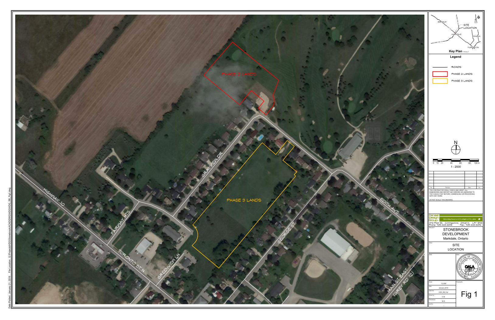
The Phase 2 lands are located north east of the Phase 1 lands (See Figure 1). The lands are currently
used as manicured lands adjacent to the first fairway of the Markdale Golf and Country Club. Other
adjacent land uses include agricultural and residential uses.
Vegetation on the Phase 2 lands includes mown grass and hedgerow and small (2-3 trees each) scatted
copses of immature trees. Tree species represented within the subject lands are White Cedar, Norway
Spruce, White Pine, Basswood, Locust, Black Cherry, White Ash and Sugar Maple. The understory of
trees within the hedgerow was dominated by Hawthorn and Buckthorn.
2.2 Phase 3 Lands
The lands for Phase 3 are located on a vacant parcel of land currently surrounded by residential uses
(See Figure 1). These lands have previous use as open space and as a youth soccer field. As such the
vegetation includes mown grass and a few trees scattered within the subject lands and along the rear
yards of the adjacent residential lands. Vegetation on the Phase 3 lands includes mown grass and trees
located along the rear yards of abutting lots. Three small copses of trees were noted within the subject
land parcel. None of the species observed were significant. Trees identified within the Phase 3 area
included Basswood, Black Walnut, Sugar Maple, Austrian Pine, Green Ash, Poplar Spp, Manitoba Maple,
Scots Pine and Norway Spruce. Perimeter trees and shrubs on the abutting lots line the boundary of the
subject lands and are mostly representative of non-native, hybrid landscape plantings.

Hon. Paul Bonwick, P.C.
January 19, 2018
Page 3 of 5
3. Field Investigations
A site visit was conducted on January 18, 2018 to determine the presence/absence of SAR. Given the
timing of the visit the investigations included a search for Butternut trees (Juglans cinerea) and Bat Cavity
Trees (BCT).
The Draft Ecoregion 6E Criterion Schedule indicates that deciduous and mixed forests having a density of
"wildlife trees" having diameter at breast height (dbh) greater than 25cm exceeding 10/ha are candidates
for consideration as bat habitat- specifically Maternity Colony Habitat. Bat Cavity Trees (BCTs). A BCT
was defined as a tree having dbh >25cm that provided holes clearly leading to areas of cavity formation
internal to the tree. Such areas often originate from limb shedding/knot holes and through excavation by
woodpeckers. For knot holes or woodpecker holes to qualify as bat cavities they had to advance into an
area of rotted heartwood such that they provided a cavity within the tree large enough to accommodate 5
bats or more offering them protection from the elements (i.e. simple knot or woodpecker holes do not
qualify). Cavities had to be located more than 3m above ground to qualify as bat cavities. Trees with dbh
> 25cm having patches of loose bark more than 3m above ground providing cover for groups of bats were
also considered as a BCT.
4. Development Proposal
The current development proposal for the subject lands includes the development of townhouse units on
both the Phase 2 (24 units) and Phase 3 (54 units) lands.
5. Impacts Assessment
The following represents a summary of the potential impacts assessed as related to implementation of
the development proposal within or adjacent to the noted on-site natural heritage features. The
assessment is based on the use of available information garnered from the background information
review and field reconnaissance of any natural heritage features on or adjacent to the subject lands. 5.1 Significant Wetlands, Significant Coastal Wetlands and Other Wetlands
There are no identified unevaluated wetlands or Provincially Significant Wetlands (PSWs) on or adjacent
to the subject lands.
5.2 Significant Wildlife Habitat
The subject lands do not contain any significant wildlife habitat.
5.3 Significant Woodlands
There are no Woodlands on the subject lands.

Hon. Paul Bonwick, P.C.
January 19, 2018
Page 4 of 5
5.4 Significant Valleylands
There are no significant valleylands to be considered. 5.5 Threatened/Evaluated Species and Habitats (SAR)
A search of the NHIC database did not identify any significant species, rare or specialized habitats on the
subject lands. Although the NHIC does contain a record of a Restricted Species, it is understood that this
is a sensitive turtle species which is not listed as as either extirpated (EXT), endangered (END),
threatened (THR) or of Special Concern (SC). A search of the Breeding Bird Atlas of Ontario found that 5
species of birds, all listed as Threatened, have been recorded within the 10km x 10km grid which includes
the subject lands. Habitat for these species does not exist on the subject lands. No Butternut trees were
observed within the Phases 2 and 3 subject lands.
5.6 Fish Habitat
There is no fish habitat on the subject lands.
6. General Recommendations and Mitigations
The general mitigation measures and recommendations described herein are provided to further ensure
that development of the subject lands proceeds in an environmentally and socially responsible manner
with the aim of reducing impacts on the functions and integrity of the study area’s natural heritage
features, during the construction process.
1. That the recommendations and mitigations identified below become Conditions of Approval to be
addressed as a part of the detailed Engineering and Landscape submissions to support the final
design and future submissions.
2. The Grading/Drainage Plan must designate specific locations for stockpiling of soils and other
materials including snow (for both during and after construction) to reduce runoff potential;
3. A spill-prevention program should be developed, as well as ensuring that vehicle re-fueling
occurs off-site;
4. Sediment fencing should be erected on the down slope of all fill material to prevent sediment
transport, until full vegetation cover has been achieved on all disturbed areas. The fences should
subsequently be monitored on a scheduled basis during construction, and checked both before
and after all precipitation events to ensure stability;
5. Barrier fencing should be placed at the property line or at the drip-line of trees on adjacent lands.
Avoid inadvertent root compaction. In the event that roots or branches of trees to be protected are
inadvertently damaged during construction, they should be clean cut as soon as possible.
Exposed roots should then be covered with topsoil and mulched under the guidance of a
biologist, arborist or landscape architect.

Hon. Paul Bonwick, P.C.
January 19, 2018
Page 5 of 5
6. Areas that are to be cleared for development but are planned to later undergo landscape
plantings should implement plans that includes native seed/planting materials wherever
appropriate.
7. Organic landscaping methods should be used to minimize impacts to the plant community and
reduce the chance of non-native or invasive species from establishing.
8. When possible, in order to reduce the potential for negative impacts on the surrounding area’s
breeding birds, it is recommended that construction and its associated noises be minimized
between 5:00 a.m. and 10:00 a.m. from late May to late July. These time windows are the peak
calling and breeding periods for the majority of Ontario’s breeding birds; a bird’s ability to sing and
be heard by potential mates and defend against rivals is imperative to their reproductive health
and success. The Federal Migratory Bird Convention Act and its regulations prohibit the damage
or destruction of a migratory bird, its nest and eggs. This Act is currently under review to allow for
‘incidental take’ during development, however currently destroying nests during the course of
construction may result in charges.
7. Conclusion
Based on the information known from the site we conclude that the proposed development of the
Phase 2 and Phase 3 Stonebrook Development lands is feasible from a natural heritage
perspective, in so long as the recommendations and mitigations identified herein are
implemented.
If you require additional information regarding this submission, please do not hesitate to contact us.
Sincerely, Hensel Design Group Inc.
Michael J. Hensel, OALA, CSLA Senior Development Consultant
Enclosures: Figure 1
GEO
RGE
ST
EDITH AVE
GRAY
VIEW D
R
TORONTO ST N
GREE
NVIEW L
N
FAIR
WAY
HTS
HIGHWAY 10
MAIN
ST E
AST
(GREY
RD 12)
HDG_SB_Fig1
Date P
lotted: January 21, 2018
F
ile Location: Q
:\P
rojects\H
DG
\S
tonebrook\A
CA
D\D
WG
\H
DG
\H
DG
_S
B_F
ig1.dw
g
PHASE 2 LANDS
(n.t.s.)
Legend
SEAL SEAL
Drawing No.Scale:
Date:
CAD File:
Drawn by:
Checked by:
Job No.:
No. Revision Date Init
Key Plan
PROJECT
TITLE
THE CONTRACTOR SHALL CHECK AND VERIFY ALL
DIMENSIONS AND REPORT ANY ERRORS OR OMISSIONS TO
THE CONSULTANT BEFORE COMMENCING OR PROCEEDING
WITH ANY WORK.
DO NOT SCALE THIS DRAWING.
STONEBROOK
DEVELOPMENT
Markdale, Ontario
SITE
LOCATION
1:2,500
January 2018
C.M.
M.H.
-
Fig 1
Phone: 705-443-8394 Fax.: 705-443-8494
1 : 2500
4010 20 60 100 m0 80
PHASE 3 LANDS
ROADS
MARKDALEEUGENIA
FLESHERTON
BERKELEY
HWY 10
GREY RD 12
GR
EY R
D 12
SITELOCATION
PHASE 2 LANDS
PHASE 3 LANDS