08 urban design - nyc
TRANSCRIPT

8-1
Chapter 8: Urban Design and Visual Resources
A. INTRODUCTION This chapter considers the potential for the Gateway Center at Bronx Terminal Market project to have significant adverse effects on urban design and visual resources.
As defined in the 2001 City Environmental Quality Review (CEQR) Technical Manual, urban design components and visual resources determine the “look” of a neighborhood—its physical appearance, including the size and shape of buildings, their arrangement on blocks, the street pattern, and noteworthy views that may give an area a distinctive character. The following analysis addresses each of these characteristics for existing conditions and the future without and with the proposed actions for the years 2009 and 2014, when the two phases of the Proposed Project are expected to be completed. The study area for urban design and visual resources is defined as extending ¼-mile from the boundary of the project site; however, the analysis will also consider views across the Harlem River from Manhattan.
The following analysis concludes that the Proposed Project would not have a significant adverse effect on the area’s urban design and visual resources. The project would substantially improve the condition of the project site. The demolition of the project site buildings could create new views to visual resources; however, the construction of the proposed buildings could eliminate other views from the project site or the surrounding area. The Proposed Project is expected to enhance the vitality of the project site and surrounding area by increasing access to and landscaping and activity on the project site. Although the Proposed Project will include the creation of buildings that are taller and bulkier than the existing buildings, these changes are not considered to be adverse, as they would improve the visual quality of the site and would be compatible with the bulk and use of buildings in the surrounding area.
B. EXISTING CONDITIONS
PROJECT SITE
URBAN DESIGN
The project site is approximately 18 acres in size and is located in the West Haven section of the Bronx. The project site is bounded by the Metro North Rail Road to the north, River Avenue to the east, 149th Street to the south, and Exterior Street to the west (see Figure 8-1). The project site is currently occupied by three low-scale warehouse buildings (Buildings B, C, and D) and the Bronx House of Detention, as well as paved areas for parking. (A six-story refrigerated warehouse building on the project site, Building A, was recently demolished.) The low-scale warehouse buildings are part of the Bronx Terminal Market, a wholesale food market. The paved areas provide truck parking space for the market when needed, as well as parking space for events at Yankee Stadium, which is located approximately 400 feet from the northern end of the project site. The northern portion of the project site, north of the former Building A and the

Gateway Center at Bronx Terminal Market FEIS
8-2
Major Deegan Expressway ramp, had previously been the site of a farmers market on weekdays and serves as additional parking space during Yankee games. The farmers market was relocated to an off-site location managed by the New York City Department of Parks and Recreation (NYCDPR) (i.e., Yankee Stadium parking lots 13A and 13B located along the Harlem River) in March 2005.
The Bronx House of Detention is an 8-story, rectangular building with small pavilions at each end and a 10-story central pavilion. The building is faced with gray brick and stone and long columns of vertical windows run uninterrupted above the base of the building. An 8-story addition to the building is perpendicular to the original structure on its west façade. It is also faced in gray brick and has long horizontal bands of windows. Several trailers and temporary structures are also located on the building’s site. As the Bronx House of Detention is in reserve status and is currently closed, it has taken on a derelict and abandoned look (see Photograph 1 of Figure 8-2).
Building B is located on the east side of Exterior Street north of its intersection with Cromwell Avenue. It comprises a group of small, connected spaces within a reinforced concrete structure. The 2-story building is unpainted and has few decorative elements beyond a stucco corbel course running along the top (see Photograph 2 of Figure 8-2). Large openings covered with metal grates are on the first floor, while large, multi-paned rectangular window openings are on the second floor. The second floor windows have been sealed with a variety of materials, mainly concrete block. The building is built to the street line, is in fair condition, and is partially occupied. It is painted with advertising signs indicating the nature of its use as a wholesale food market building.
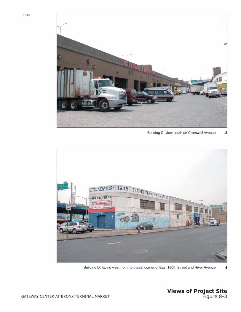
Building C, located just south of the Bronx House of Detention, is a 1-story brick building with large, paired openings. It is unpainted and has little decoration beyond a red advertising sign which reads “Cuba Tropical.” The building is rectangular in form and extends the length of the block between Cromwell and River Avenues and north from 150th Street to the Bronx House of Detention. With few ground-floor openings, this creates a long streetwall (see Photograph 3 of Figure 8-3).
Building D is a 2-story stucco building located at the southeast corner of the project site, at the intersection of 149th and Exterior Streets and River Avenue. It is a small, polygonal building with “Bronx Terminal Market, City of New York, 1935” painted in large lettering at the top of the southeast corner of the building (see Photograph 4 of Figure 8-3). It is built to the street line, is in fair condition, and is partially occupied.
The project site is dominated by the presence of an elevated structure, the Major Deegan Expressway, which forms the western boundary of the project site above Exterior Street (see Photograph 5 of Figure 8-4). While the Expressway is elevated, it is located at a level low enough to block views to and from the site. In addition, entrance and exit ramps for the Expressway are located within the boundaries of the project site and affect both vehicular and pedestrian traffic by creating intersections which are difficult to cross (see Photograph 6 of Figure 8-4).
The streets within the project site are arranged in an irregular pattern with some streets, such as 151st Street, cutting through the site at a diagonal and terminating upon their intersection with other streets. Some of the streets are also unpaved and/or in poor condition. Exterior Street is paved with Belgian block, which is somewhat covered by blacktop. Cromwell Avenue is completely paved with Belgian block. These streets are both in fair condition; the paving is worn

Chapter 8: Urban Design and Visual Resources
8-3
down in some parts, exposing the Belgian blocks, and in other parts the blocks have come loose or are broken. There are unused, partially obscured railroad tracks running parallel east of Building B. The sidewalks are only slightly elevated and in some points they are almost flush with the ground. Often delivery trucks and vans are parked on them, making them unusable for pedestrian traffic. Running along the western edge of Building B is a covered walkway, approached by a set of three steps. Delivery trucks and vans unload here and often block the walkway.
The project site slopes upwards towards River Avenue, particularly near 151st Street. The condition of the streets, the irregular street pattern, and the elevated Expressway structure limit the pedestrian accessibility and experience on the project site. In addition, the project site is generally inaccessible to the public due its industrial use and lack of amenities, as well as the presence of large delivery trucks which frequently pass through the streets. There is little to no landscaping or vegetation on the site, adding to its somewhat degraded appearance.
VISUAL RESOURCES
The Harlem River is generally visually inaccessible from the project site, due to the presence of the elevated Expressway and the Bronx Terminal Market buildings west of Exterior Street. In addition, the limited views to the riverfront that exist are impeded by the Oak Point Link rail connection, which runs on a trestle along the Harlem River parallel to the shoreline and the project site.
From certain sections of the southern portion of the project site the 145th Street Bridge is visible; however, views of this resource are, for the most part, hampered by the presence of the elevated Expressway and the Bronx Terminal Market buildings west of Exterior Street.
Yankee Stadium and the Bronx House of Detention are visual landmarks, and are visible from various points on the project site. Yankee Stadium is visible from the project site along River and Cromwell Avenues; elsewhere, the elevated Expressway and existing buildings blocks views of it. The Bronx House of Detention is also mainly visible along Cromwell and River Avenues, though often it is only the western (rear) elevation that is visible (see Photograph 5 of Figure 8-4, above). The eastern or front façade is visible from the intersection of River Street and 151 Street and from approximately 200 feet to the north and south of this intersection. The Bronx County Courthouse, located on 158th Street between Walton and Gerard Avenues, is a large, boxy, structure approximately ten stories in height. It is only visible from the northern portion of the project site.
There are no significant view corridors within the project site. On Exterior Street views to the north and the south are limited by the elevated Expressway and terminate with views of its entrance and exit ramps (see Photograph 7 of Figure 8-5 and Photograph 6 of Figure 8-4, above). Other south-facing views are of industrial and warehouse buildings located just south of 150th Street. Views looking east from the project site along 150th and 151st Streets, both of which slope slightly uphill to the east, terminate with buildings along the Grand Concourse. Views looking west from the project site are primarily hampered by the Bronx Terminal Market buildings along the west side of Exterior Street (Buildings F, G, H, and J). While there are small spaces between the buildings, these spaces are covered in overgrown trees and debris, surrounded by metal chain-link fencing, and have metal walkways on the second stories, all of which block views to the waterfront and greatly reduce any visual links between the project site and the waterfront.

Gateway Center at Bronx Terminal Market FEIS
8-4
STUDY AREA
The study area for urban design and visual resources is a ¼-mile perimeter from the project site boundary. The study area includes a portion of East Harlem located in northern Manhattan. The Bronx study area is roughly bounded by Jerome Avenue and 161st Street to the north, Sheridan Avenue to the west, and 144th Street to the south. In Manhattan the study area is roughly bounded by West 141st Street to the south, Lenox and Seventh Avenue to the west, and Macombs Place to the north. The Harlem River runs through the study area. The discussion below focuses first on the area’s urban design—its basic layout and structures—and then describes its visual resources.
URBAN DESIGN
Street Pattern, Block Shapes, and Natural Features
The Bronx The street pattern of this section of the Bronx does not follow the orthogonal grid. Instead, the wider north-south avenues run on a slight angle to the east. Narrower streets run on an angle from northwest to southeast. This creates irregular-shaped blocks as well as long blocks which are uninterrupted by cross streets. In addition, the superblocks created by Yankee Stadium and its associated parking structure are irregularly shaped and create impediments to pedestrian traffic.
The most prominent natural feature in the study area is the Harlem River. The river is narrow and separates this section of the Bronx from the northern section of Manhattan. It is easily crossed via the 145th Street or Macombs Dam Bridges, which connect Manhattan and the Bronx. The waterfront is not easily accessible within the study area, due to the presence of entrance ramps for the elevated Expressway and the Bronx Terminal Market and warehouse buildings along the water. The topography of the study area is hilly and slopes down from the Grand Concourse, located three blocks east of the project site, towards the water. The topography of the area west of Exterior Street near the project site is relatively flat.
East Harlem
The street pattern of the East Harlem section of the study area follows the regular grid pattern. Seventh and Lenox Avenues are wide and run north-south, while narrower side streets run east-west. There is a mix of building styles and types most of which are either low-scale residential with ground floor retail or high-rise residential towers. The lower scale buildings include a school, commercial and residential structures, and a New York City Transit bus depot.
In addition to the Harlem River, natural features in the East Harlem study area are limited to the parks along the Harlem River. This includes the Colonel Charles Young Park located from West 145th Street to West 143rd Street and bounded by the Harlem River on the east and Lenox Avenue on the west. This park has tennis courts, softball fields and some benches for seating. Other open space includes the Frederick Thomas Playground, located on Seventh Avenue between West 154th and 150th Streets and associated with the Harlem River Houses.

Chapter 8: Urban Design and Visual Resources
8-5
Streetscape The Bronx
The streetscape of the study area is urban and industrial in character. The streets outside the project site are flanked by concrete sidewalks. The majority of the study area has an underutilized, degraded quality and has very little streetlife, due to the nature of the businesses in the area: the Bronx Terminal Market, a truck rental business, a recycling center, auto repair shops, and parking lots. There are unused, partially obscured railroad tracks running parallel to the Bronx Terminal Market buildings west of Buildings F, G, H, and J. Running along the eastern edges of Buildings F, G, and H is a covered walkway, approached by a set of three steps. Delivery trucks and vans unload here and often block the walkway.
With the exception of 149th Street there is little pedestrian activity or street life in the southern and eastern portion of the study area. 149th Street, which is wider than other streets in the area, serves as the entrance and exit point for the 145th Street Bridge. It also serves as a major thoroughfare with a city bus line. Unlike other streets in the study area, restaurants and small retail shops line 149th Street, increasing the pedestrian activity and traffic.
On the eastern edge of the study area is the Grand Concourse, a wide and major thoroughfare for this section of the Bronx. In comparison to the majority of the study area, the Grand Concourse has active pedestrian and vehicular traffic. Most of the Grand Concourse in the study area is lined with buildings associated with Hostos Community College which adds to the street life. In addition, Franz Segal Park runs along the Grand Concourse which improves the appearance of the Concourse with its associated street furniture and street trees (see Photograph 8 of Figure 8-5).
There are few street trees or street furniture in the study area; closer to Yankee Stadium along 153rd Street, there are some street trees and landscaping. There are standard “cobra-head” lampposts with banners advertising the Yankees ball team. All of the streets are paved, and the sidewalks along Gerard and River Avenues are wider than those of the surrounding streets. Two bridges, which are located between 151st and 153rd Streets along River and Gerard Avenues, cross over sunken railroad tracks for the Metro North Rail Road (see Photograph 9 of Figure 8-6). Two auto-repair businesses are located on the blocks of Gerard Avenue between 150th and 153rd Streets. Damaged cars line both sides of the avenue and run almost the entire length of the block (see Photograph 10 of Figure 8-6). The northern portion of the study area is dominated by Yankee Stadium, a related parking structure, and baseball fields in Macombs Dam Park. The western section of the study area extends to the Harlem River which, as described above, is generally inaccessible and does not contribute to the feel of the study area.
East Harlem
The streetscape in the Manhattan section of the study area is urban and residential in character and is developed with a mix of low-scale commercial and residential buildings and high-rise apartment buildings. The area has a vibrant street life due to the high density of housing, the commercial businesses, and the school. The sidewalks are wide along the avenues and narrow on the side streets. There is a limited amount of street furniture, mostly standard metal light posts, fire hydrants, electronic parking meters, and phone booths. The Colonel Charles Young playground and the Harlem Tennis and Recreation Center located just west of the Harlem River between West 142nd and 145th Streets provide a visual break in the streetscape. The study area is dominated by the Esplanade Gardens, a group of five residential towers set at angles to each other allowing for some open space and visual access to the waterfront. However, access to the

Gateway Center at Bronx Terminal Market FEIS
8-6
waterfront between the apartment buildings is blocked by parking lots and a metal chain link fence. There are also some evenly placed street trees running along the perimeter of the Esplanade Gardens site.
Along Seventh Avenue a consistent streetwall is created by the lower scale buildings which are residential with ground floor retail, adding to the pedestrian activity along the Avenue. The street wall is broken up by a playground located along Seventh Avenue from West 151st Street and West 153rd Street which contains park benches, groups of shade trees, and recreation space. Additional street traffic is due to the Frederick Douglass Academy, a local public school.
Building Uses, Bulk, and Arrangements
The Bronx The area of the Bronx surrounding the project site includes the remaining buildings of the Bronx Terminal Market, other low-scale buildings, and Yankee Stadium and its related structures. Buildings F, G, H, and J of the Bronx Terminal Market are adjacent to piers on the Harlem River. Buildings F, G, and H are similar in style to Buildings B and D on the project site. Building J is a rectangular brick building with a 3-story central pavilion flanked by 2-story end pavilions. The window and other building openings are covered in either concrete or cement brick, and the building is covered with graffiti on the first floor (see Photograph 11 of Figure 8-7).
The area of the piers immediately west of the Bronx Terminal Market buildings is used for delivery truck parking. The piers are not easily accessed, and views to the waterfront from the piers are blocked by the trucks, metal fencing, and concrete traffic barriers. The piers look rundown, and small spaces between the buildings are not landscaped and contain garbage and other debris, adding to the industrial and dilapidated feel of the area (see Photograph 12 of Figure 8-7). Metal walkways placed at the second story level connect the buildings.
Directly south of the project site are entrance and exit ramps for the Expressway and a one-story wholesale restaurant supply store with a fenced-in parking lot. There are other one-story industrial buildings as well as a recycling center near the Expressway overpass. A gas station and auto repair shop is located on the corner of River Avenue and 150th Street, near the entrance to the 145th Street Bridge. Along Gerard Avenue there are several 1-story buildings of brick and/or concrete with large openings to allow vehicles to enter the repair shops; one has metal gates at the openings and barbed wire along the roof line. These buildings run almost the entire length of the block and are in fair condition, with some broken windows and graffiti. Along the west side of Gerard Avenue between 151st and 153rd Streets is a sunken, paved parking lot surrounded by trees. The trees are overgrown and extend onto the sidewalk. Litter and other debris have accumulated under the tree growth adding to the derelict feel of the study area (see Photograph 13 of Figure 8-8). In the northeastern section of the study area, along 153rd Street between Gerard and River Avenues, are the Oxford Knolls, one of the only residential buildings located within the study area. They are six stories in height, clad in coarse red brick, and have distinct Tudor ornamentation including steeply pitched gables and mock timbering (see Photograph 14 of Figure 8-8).
The northern part of the Bronx study area is composed of parking lots for Yankee Stadium, which are enclosed by chain link fences; a 4-story concrete parking garage; and a baseball field. The parking garage occupies the entire triangular block bounded by 153rd and 157th Streets and River Avenue. This 4-story parking structure is open on each floor and creates a consistent street

Chapter 8: Urban Design and Visual Resources
8-7
wall. Yankee Stadium is located at the northeastern edge of the study area and is taller than the surrounding buildings. Yankee Stadium is approximately 130 feet tall and is shaped in the traditional style of a baseball stadium. The words “Yankee Stadium” are spelled out in 1-story high blue letters along the western side of the stadium. The portion of the stadium located near the study area is the concession and ticket area; there is a small plaza space containing concrete blocks with flower planters, lampposts, and some mature trees (see Photograph 15 of Figure 8-9).
In contrast to the rest of the study area, Walton Avenue is dominated with residential buildings. The buildings along Walton Avenue are similar in style and bulk to the apartment houses along the Grand Concourse. They are six stories in height, and clad in brick with brick exterior details.
East Harlem
The buildings in the Manhattan study area are primarily residential and vary between high-rise towers and lower scale multi-family units, some with ground floor retail. The Esplanade Gardens dominate the area; they are thirty stories in height, faced in red brick with enclosed, exterior balconies and placed at an angle to the street. They are supported by one-story round concrete piers. In addition, the Harlem River Houses, a stretch of residential buildings, run along Seventh Avenue. They are approximately three stories in height, also faced in brick with small courtyards. Three-story residential with ground floor commercial buildings line the western side of Seventh Avenue.
There is one school in the East Harlem study area. The Frederick Douglass Academy, an intermediate and high school, is located on Seventh Avenue between West 149th and 150th Streets. The Academy is three stories high, constructed of concrete, and is partially enclosed by a metal chain link fence.
A Metropolitan Transit Authority bus depot is located at the corner of Lenox Avenue and West 146th Street. It occupies the majority of the block with entrances and exits onto Lenox Avenue and creates traffic congestion at the corner of Lenox Avenue and West 147th Street.
VISUAL RESOURCES
The Bronx Three bridges are visible from the study area. On 149th Street, in the southern portion of the study area, views of the 145th Street and 138th Street Bridges are possible. From the northern section of the study area the Macombs Dam Bridge is visible. The Macombs Dam Bridge is most visible looking west from the Yankee Stadium area (see Photograph 16 of Figure 8-9). Both bridges, the Harlem River waterfront, and Manhattan are visible from the portion of the study area west of the Bronx Terminal Market buildings; however, this area is generally not publicly accessible.
There are no other views of the Harlem River waterfront from the project study area. Views are blocked by the buildings both on the project site and in the study area. Therefore, except for the restricted portion of the study area west of the Bronx Terminal Market buildings, there is no visual link between the study area and the waterfront. Views to the north and to the south along the study area’s streets are long and do not end in any prominent or notable features (see Photograph 17 of Figure 8-10). The exception is the intersection of 153rd and 157th Streets, from which the southwestern corner of Yankee Stadium is in clear view. Views to the east terminate at the Grand Concourse, three blocks from the eastern edge of the project site. Again,

Gateway Center at Bronx Terminal Market FEIS
8-8
there are no prominent or notable features to these view corridors (see Photograph 18 of Figure 8-10).
Visual landmarks within the study area include Yankee Stadium and the Bronx House of Detention. Yankee Stadium is the most prominent and is visible from almost all parts of the study area. The Bronx House of Detention is also visible from many parts of the study area. Views of the Bronx House of Detention are most prominent looking south along River Avenue from 153rd Street or looking north along Cromwell Avenue. Due to the sloping topography of the study area and some of the low-scale buildings, views of the Bronx House of Detention are sometimes blocked, or limited to only the very top floor. For the majority of the study area, views are blocked by the parking structure for Yankee Stadium and the Oxford Knolls apartment buildings.
East Harlem Views of East Harlem from the study area are almost completely blocked by the 1- and 2-story industrial buildings located along the waterfront and on the project site. At the entrance/exit ramps for the Expressway and the 145th Street and Macombs Dam Bridges, some views of East Harlem are possible. As described above, restricted views of East Harlem are available from the portion of the study area west of the Bronx Terminal Market buildings. The Esplanade Gardens, a high-rise housing complex across the river in East Harlem, is the most prominent visual feature of this view (see Photograph 19 of Figure 8-11).
From East Harlem, the project site, Yankee Stadium, the Bronx House of Detention, and the Bronx County Courthouse are visible only from the small parks around the Esplanade Gardens and the small park associated with the Harlem River Houses (see Photograph 20 of Figure 8-11). The best views of the study area’s visual landmarks, including Yankee Stadium, the Bronx House of Detention, and the Bronx County Courthouse, are from the 145th Street and Macombs Dam Bridges (see Photograph 21 of Figure 8-12).
The project site and study area are also visible from the elevated Major Deegan Expressway. The Bronx House of Detention and Yankee Stadium are the most prominent features visible from the Expressway.
C. THE FUTURE WITHOUT THE PROPOSED ACTIONS
2009
PROJECT SITE
One major project proposed within the study area that could be developed by 2009 is the construction of a new stadium for the New York Yankees, in the portion of Macombs Dam Park located north of the existing stadium across 161st Street. The potential urban design and visual resources impacts of that No Build project are discussed in Chapter 22, “Future Conditions with a Relocated Yankee Stadium.”
STUDY AREA
There are no major residential or commercial construction projects planned for the study area by 2009. However, two institutional projects are planned for the study area by 2009. The New York City Department of Homeless Services has plans for a new 60,000 square feet (sf) Emergency

Chapter 8: Urban Design and Visual Resources
8-9
Assistance Unit at 151st Street and Walton Avenue to replace the existing facility at this location. Hostos Community College has plans to renovate a 125,000 gsf academic building, and has future capital investment projects that are pending budget allocation. Finally, outside of the study area, Lincoln Hospital is in the process of constructing several new facilities, including a 30,000 sf labor and delivery center and a 2,000 sf MRI unit. The hospital also has plans for a renovated emergency room, women’s option center, and upgraded existing 650-space parking garage. 149th Street between Griffin Place and Exterior Street will be reconstructed to improve street lighting, sidewalks, and curbs. This will improve pedestrian access to the area, as well as its urban design. The New York City School Construction Authority (SCA) has proposed the construction of an approximately 275,000 gross square foot, 2,300-seat school complex on the northeast corner of Concourse Village West and 153rd Street, just north of the planned East 153rd Street Bridge. The proposed school complex, which would house four school organizations, would be constructed on a site that is currently a vacant lot sunken 15 to 30 feet below street level and currently surrounded by a chain link fence. The school complex would visually enhance the streetscape by replacing a vacant lot with active uses. Additionally, Lou Gehrig Plaza, located just outside the ¼-mile study area along 161st Street between the Grand Concourse and Walton Avenue, is being redesigned to function as a civic gathering space. The newly designed plaza will represent a significant streetscape improvement on a site currently used for parking.
2014
PROJECT SITE
No changes are expected to occur on the project site without the proposed actions by 2014.
STUDY AREA
A widening of the Major Deegan Expressway is planned for completion by 2011-2012. This reconstruction would improve access to the area, including the project site. In addition, the Metro North Rail Road has been studying the possibility of establishing a station in the study area at least since the mid-1980s. If this station were created, it would improve access to the area.
Since New York City will not be hosting the 2012 summer Olympics, the area south of the project site on the Harlem River that had been proposed as the velodrome venue will be considered for other possible uses.
D. PROBABLE IMPACTS OF THE PROPOSED ACTIONS
2009
PROJECT SITE
Urban Design The Proposed Project would alter the street pattern of the project site by demapping 150th Street between River Avenue and Exterior Street, and eliminating 151st Street between River and Cromwell Avenues, and Cromwell Avenue between Exterior Street and the Metro North Rail Road tracks. This change is not considered to be adverse, as these streets are currently

Gateway Center at Bronx Terminal Market FEIS
8-10
underutilized and are not a defining element of the area’s urban design. The Proposed Project also would substantially alter the appearance of the project site by replacing two of the existing one- and two-story, long, narrow industrial buildings and the 8- and 10-story Bronx House of Detention with a series of retail establishments of up to 96 feet in height and a 6-level parking garage. The proposed buildings would be larger and squarer in form than the existing buildings, and their expected materials, coloration, and style would be different and more modern than those of the existing buildings on the project site. Building materials could include pre-cast concrete and brick, and the buildings are expected to have a warehouse aesthetic incorporating a variety of storefronts with industrial lighting and signage. While the proposed buildings would be considerably different than the existing buildings, the existing buildings are currently unutilized or underutilized and have a neglected quality, and the proposed buildings would be expected to improve the visual quality of the site. The renovation of Building D and its reuse for retail would also be expected to improve the visual quality of the site. The proposed and retained buildings also would maintain the existing streetwalls on Exterior Street and River Avenue. The proposed retail and parking uses would be expected to generate more pedestrian activity than the existing wholesale and retail uses. The signage to be erected on the sides of the proposed buildings and above Retail Building E.1 would include elements intended to create a visual rhythm along the Major Deegan Expressway.
The Proposed Project would create landscaped passageways between the proposed buildings, allowing for better pedestrian access, and would introduce street lighting and trees to improve the visual appearance of the project site (see Figure 8-13). The landscaped passageways across the project site would not be built upon and would be available for public use, facilitating access to the waterfront public open space to be created by the City.
The Belgian block paving on Exterior Street would be removed as part of the Proposed Project; however, it is possible that the pavers would be incorporated into the design of the public open space. In summary, the Proposed Project is not expected to have a significant adverse impact on the urban design of the project site.
Visual Resources The demolition of the Bronx House of Detention could create new views to Yankee Stadium from the project site; however, the construction of the proposed buildings could eliminate other views of the stadium from the project site. Views of the Bronx House of Detention from the project site are mainly of the rear or western façade which is not original to the building.
STUDY AREA
Urban Design Street Pattern, Block Shapes, and Natural Features
The Proposed Project would not alter the street pattern, block shapes, or natural features of the Bronx or East Harlem study area.
Streetscape
The Proposed Project would enhance the vitality of streets in the study area by introducing new commercial and parking uses and pedestrian activity to the project site. It would also improve the appearance of the area’s streetscape by adding street lighting and landscaping. The lighting of the pedestrian walkways could include industrial light fixtures as well as decorative accent lighting. The Proposed Project would include signs that would be visible from the surrounding

Chapter 8: Urban Design and Visual Resources
8-11
area. Illuminated signs identifying retail tenants would be located on the renovated Building D (aka Retail Building E.1) and Retail Buildings A and B/F and would be located along the public streets that run through and along the project site. Taller backlit signs approaching heights of approximately 155 feet and 100 feet, respectively, would be located along Exterior Street at the corners of Retail Buildings B/F and along River Avenue on the proposed parking garage. The proposed signage would draw attention to the retail development and the surrounding recreational space and would create visual interest along the Major Deegan Expressway. The Proposed Project would not affect other streetscape elements within the Bronx study area.
The Proposed Project would not affect streetscape elements in the East Harlem study area.
Building Uses, Bulk, and Arrangements
The Proposed Project would introduce a land use that is complementary to the surrounding area, as it would create major retail facilities which would serve residents in the Bronx and northern Manhattan. The height of the proposed buildings would be similar to that of the residential buildings located along 153rd Street and along Gerard and Walton Avenues north of 153rd Street. In addition, Hostos Community College, located at 145 Street and the Grand Concourse, is comprised of buildings of a similar height and bulk, and Yankee Stadium, to the north of the project site, is approximately 130 feet tall. Therefore, the proposed buildings would be in keeping with the height and bulk of some of the existing structures in the study area. The expected design of the buildings could be referential to the surrounding industrial scale buildings along the waterfront. The renovated Building D would be in keeping with the height, bulk, and design of the extant Bronx Terminal Market buildings on the west side of Exterior Street.
In the future with the Proposed Project, it is anticipated that the City, with contributions from the project sponsor, would develop a portion of the waterfront area west of Exterior Street with a 2-acre public open space. The City is committed to developing the off-site public open space by the Proposed Project’s 2009 Build year. The programming of this open space and the actions required for its development are yet to be determined. This new open space would facilitate access to the Harlem River, and views from Exterior Street to the waterfront would be improved.
The Proposed Project would not affect building uses, bulk or arrangements in the East Harlem study area.
VISUAL RESOURCES
While the Proposed Project would result in the demolition of the Bronx House of Detention, this resource is only visible from specific locations within the study area and from the elevated Expressway. Additionally, views of the resource are mainly of the rear or western façade which is not original to the building. The removal of the Bronx House of Detention could also allow for new views of Yankee Stadium from the study area. The proposed signage at the corners of the proposed buildings could obstruct some views from the Major Deegan Expressway to the surrounding area; however, because they are available only from passing vehicles, such views are of short duration and are not considered significant. As described above, it is expected that the public open space to be developed by the City will be constructed within the Proposed Project’s 2009 Build year. Therefore, views from Exterior Street to the Harlem River waterfront would be improved. The restricted views of the Harlem River waterfront, East Harlem, and the 145th Street and Macombs Dam Bridges from the area west of the Bronx Terminal Market Buildings G, H, and J on the west side of Exterior Street would not be affected.

Gateway Center at Bronx Terminal Market FEIS
8-12
2014
PROJECT SITE
The second phase of the Proposed Project would involve the development of a hotel on the northern portion of the project site by the 2014 Build year. This would be a new use on the project site and in the study area; however, it would be compatible with the retail center which would already exist on the project site by 2014. The development of the proposed hotel would not alter any street patterns, block shapes, natural features, or adversely affect views to visual resources from the project site.
STUDY AREA
Urban Design Street Pattern, Block Shapes, and Natural Features
The construction of the hotel would not alter any street patterns, block shapes, or natural features within either study areas.
Streetscape
The proposed hotel would not adversely affect the streetscape of the study area. It is anticipated that development of the hotel would bring greater activity to the streets of the project site and the study area in the Bronx. The proposed hotel would not impact the streetscape of the East Harlem study area.
Building Uses, Bulk, and Arrangements
The proposed hotel use would be compatible with the retail center which would already exist on the project site by 2014. At approximately 230 feet in height, the hotel would be taller than the buildings currently on the project site and in the study area; however, it would occupy a much smaller footprint than the proposed retail buildings. Therefore, its bulk would be most noticeable from across the Harlem River or along 153rd Street near the project site.
VISUAL RESOURCES
The proposed hotel would not have significant adverse impacts on the visual resources within the study area. Since the hotel would be located west of 153rd Street, it would not block existing views of Yankee Stadium and the Bronx County Courthouse from the majority of the study area. Some views of the Bronx County Courthouse from across the Harlem River in Manhattan could be eliminated; however, these are very distant views, and other, closer views to the courthouse would not be affected. Therefore no significant adverse effects to the visual resources of either study area are expected from the second phase of the Proposed Project.

GATEWAY CENTER AT BRONX TERMINAL MARKET
9.29.05
N
SCALE
0 200 500 FEET
BHODBHODBHOD
Urban Design and Visual ResourcesFigure 8-1
5
2
21
3
194
1710
18
13
1210
14
7
6
1615
20(OFF MAP)(OFF MAP)(OFF MAP)
B
D
89
11
12
1
Project Site Boundary
Photograph View Directionand Reference Number
Existing Building onProject Site
1
B
FRANZ SIGEL
WALTON AVE.

GATEWAY CENTER AT BRONX TERMINAL MARKET
1View of the Bronx House of Detention from River Avenue, facing north
2Exterior Street, view south from northern portion of project site
Figure 8-2Views of Project Site
10.3.05
GATEWAY CENTER AT BRONX TERMINAL MARKET
3Building C, view south on Cromwell Avenue
4Building D, facing west from northeast corner of East 150th Street and River Avenue
Figure 8-3Views of Project Site
10.3.05

6Major Deegan Expressway ramp, facing south from northern end of project site
5Building C and the Bronx House of Detention, view from River Avenue
Figure 8-4Views of Project Site
10.3.05
GATEWAY CENTER AT BRONX TERMINAL MARKET
YankeeStadium

Major Deegan Expressway ramp at northern end of project site 7
8Franz Sigel Park Extension, view facing east from Gerard Avenue and 153rd Street
Figure 8-5
Views of Project Site and Study Area
10.3.05
GATEWAY CENTER AT BRONX TERMINAL MARKET

9Sunken railroad tracks, view from Gerard Avenue between East 151st and 153rd Streets
10Auto repair shop and damaged cars along Gerard Avenue between 151st and 153rd Streets
Figure 8-6Views of Study Area
10.3.05
GATEWAY CENTER AT BRONX TERMINAL MARKET

Building J, view west from Exterior Street 11
12Area west of Buildings F/G/H, view north
Figure 8-7 Views of Project Site
10.3.05
GATEWAY CENTER AT BRONX TERMINAL MARKET

GATEWAY CENTER AT BRONX TERMINAL MARKET
13Gerard Avenue between 151st and 153rd Streets, view facing north
14Oxford Knolls, view facing north from Gerard Avenue and 153rd Street
Figure 8-8Views of Study Area
10.3.05

GATEWAY CENTER AT BRONX TERMINAL MARKET
15Plaza and parking structure at western edge of Yankee Stadium, view facing east from River Avenue and 157th Street
Figure 8-9Views of Study Area
16 View of Macombs Dam Bridge, view west from 157th Street
10.3.05
Yankee Stadium
Macombs DamBridge

GATEWAY CENTER AT BRONX TERMINAL MARKET
17View east from Gerard Avenue and 150th Street
Figure 8-10Views of Study Area
16View north along Gerard Avenue from 150th Street
10.3.05

GATEWAY CENTER AT BRONX TERMINAL MARKET
View of Harlem from study area, view west from 150th Street 19
20 Project site and study area, view northeast from Harlem
Figure 8-11Views of Study Area
10.3.05
Bronx County Courthouse
Bronx Houseof Detention
EsplanadeGardens

GATEWAY CENTER AT BRONX TERMINAL MARKET
View of project site and study area from 145th Street Bridge 21
Figure 8-12
Views of Project Site and Study Area
10.3.05
YankeeStadium
Bronx Houseof Detention
Bronx CountyCourthouse

10.19.05
Illustrative RenderingExterior Street
Figure 8-13GATEWAY CENTER AT BRONX TERMINAL MARKET