07 annual report - wyoming game · pdf filepowder river from accessing the middle segment of...
TRANSCRIPT

83
SHERIDAN REGION
HABITAT PROJECTS
Kendrick Dam Fish Passage and ScreeningKendrick Dam blocks eight fi sh species endemic to lower Clear Creek and the
Powder River from accessing the middle segment of Clear Creek (Figure 1). These species, which include sauger, channel catfi sh, shovelnose sturgeon, goldeye, river carpsucker, sturgeon chub, and plains and western silvery minnow, generally inhabit cool to warm water in mid to large-size, turbid streams. Passing the dam would substan-tially increase access to suitable habitat for these species in middle of Clear Creek.
Many smaller diversion structures limit fi sh movements within the 81-mile segment of Clear Creek between Kendrick and Healy dams (Figure 2). Passage at some of these potential barriers in Johnson County is being addressed via rehabilitation projects through the Lake DeSmet Conservation District Diversion Rehabilitation program. The nearest known diversion is 36 miles above Kendrick Dam.
Restoring fi sh passage at Kendrick Dam hinges on addressing guidance from the diversion operator for developing and operating fi sh passage infrastructure. The operator requires the project not impact diversion operations, or the operators discretion in operating the diversion. Efforts to explore and establish a win-win scenario will continue in 2008.
The Lake DeSmet • CD and partners are enhancing sagebrush/grassland communities in northern Johnson County. 3.3 million dollars have been granted to restore 341,220 enrolled-acres.7,000 acres (2,757 • acres this year) have been treated with aeration equipment to restore rangelands and enhance sage-grouse brood-rearing habitats.Since 2000, 215 • beaver have been transplanted to fourteen headwater streams on the Bighorn National Forests. Another 27 were moved to two ranches adjacent to the Forest. These totals include 45 beaver released in 2007.Approximately 200 • acres of wooded draws were burned this year. Three other ranches are signing up to burn additional acres in 2008.Worked with • partners to design seven diversion rehabilitation projects to address fi sh passage.
Figure 1. The 81-mile segment of Clear Creek outlined in red could be made available to up to eight native fi sh species currently confi ned below Kendrick Dam.
Figure 2. Kendrick Dam.

84
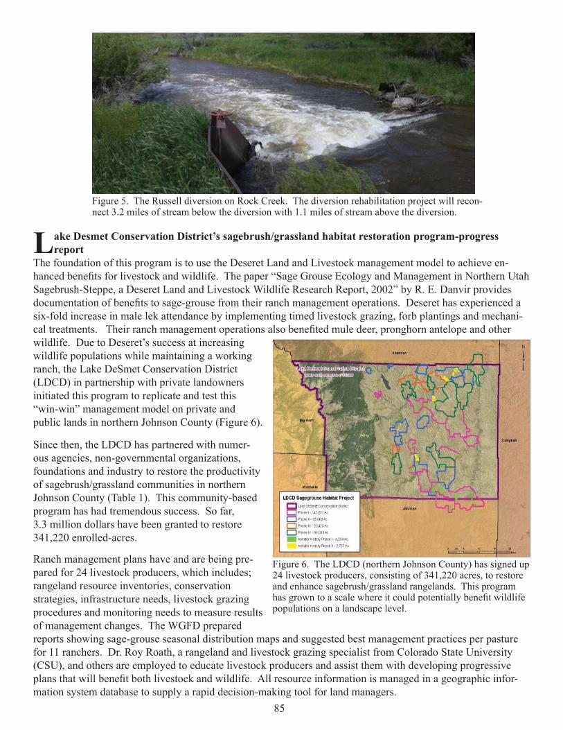
Lake DeSmet Conservation District Diversion RehabilitationThree projects – two on Clear Creek and one on Rock Creek – were completed in
2006 through the diversion rehabilitation program led by the Lake DeSmet Conservation District (LCDC). The WGFD served as a funding partner and provided design guidance to the program. The goals included revamping or bypassing dams obstructing fi sh move-ments to gain upstream fi sh passage, restoring streambank stability and channel function at the diversion sites, and maintaining or improving irrigation water delivery while reducing maintenance needs.
Three phase-2 projects were added to the ongoing program in 2007. The diversions included the Big Bonanza and Watt diversions on Clear Creek (Figure 3 and 4), and the Russell diversion on Rock Creek (Figure 5). Steady Stream Hydrology was retained by the Conservation District to complete stream assessments and develop rehabilitation designs. The Department provided funding assistance for the phase-2 project assess-ments and design efforts through the phase-1 project grant from the WGFD Trust Fund. Additional cost-share funding to implement the proposed phase-2 projects was secured through WGFD administered fi sh passage program funding. Most funding necessary to complete the phase-2 projects was secured by the NRCS through the WHIP. Implemen-tation of the phase-2 projects is expected in 2008 pending the accumulation of adequate cost-share funding. Several game and numerous nongame fi sh would benefi t from the projects.
A report titled • Response of Prairie Stream Riparian Buffers to Livestock Exclusion and Short-Duration Grazing in Northeast Wyoming-A Pre- and Post- Photographic Comparison was completed. This document has gained national attention. Another report titled • Sage-Grouse Habi-tat Conservation Benefi ts Resulting from a Leafy Spurge Integrated Pest Management Pro-gram in Northeast Wyoming was pre-pared to spotlight a sage-grouse friendly IPM program. Inventories and • monitoring assess-ments were com-pleted on 46-miles of stream.Partners participated • in a cooperative study to develop design guidelines for fi sh-friendly low head diversion dams.Investigations • continued at two large fi sh passage projects.Cost-share funding • was secured for a cooperative stream rehabilitation project on the Bighorn National Forest.
Figure 3. The Big Bonanza Diversion on Clear Creek. The diversion rehabilitation project will reconnect 16.4 miles of stream below the diversion to 3.1 miles of stream above the diversion.
Figure 4. The Watt Diversion on Clear Creek. The diversion rehabilitation project will reconnect 3.1 miles of stream below the diversion to 3.7 miles of stream above the diversion.
85
Lake Desmet Conservation District’s sagebrush/grassland habitat restoration program-progress report
The foundation of this program is to use the Deseret Land and Livestock management model to achieve en-hanced benefi ts for livestock and wildlife. The paper “Sage Grouse Ecology and Management in Northern Utah Sagebrush-Steppe, a Deseret Land and Livestock Wildlife Research Report, 2002” by R. E. Danvir provides documentation of benefi ts to sage-grouse from their ranch management operations. Deseret has experienced a six-fold increase in male lek attendance by implementing timed livestock grazing, forb plantings and mechani-cal treatments. Their ranch management operations also benefi ted mule deer, pronghorn antelope and other wildlife. Due to Deseret’s success at increasing wildlife populations while maintaining a working ranch, the Lake DeSmet Conservation District (LDCD) in partnership with private landowners initiated this program to replicate and test this “win-win” management model on private and public lands in northern Johnson County (Figure 6).
Since then, the LDCD has partnered with numer-ous agencies, non-governmental organizations, foundations and industry to restore the productivity of sagebrush/grassland communities in northern Johnson County (Table 1). This community-based program has had tremendous success. So far, 3.3 million dollars have been granted to restore 341,220 enrolled-acres. Ranch management plans have and are being pre-pared for 24 livestock producers, which includes; rangeland resource inventories, conservation strategies, infrastructure needs, livestock grazing procedures and monitoring needs to measure results of management changes. The WGFD prepared reports showing sage-grouse seasonal distribution maps and suggested best management practices per pasture for 11 ranchers. Dr. Roy Roath, a rangeland and livestock grazing specialist from Colorado State University (CSU), and others are employed to educate livestock producers and assist them with developing progressive plans that will benefi t both livestock and wildlife. All resource information is managed in a geographic infor-mation system database to supply a rapid decision-making tool for land managers.
Figure 5. The Russell diversion on Rock Creek. The diversion rehabilitation project will recon-nect 3.2 miles of stream below the diversion with 1.1 miles of stream above the diversion.
Figure 6. The LDCD (northern Johnson County) has signed up 24 livestock producers, consisting of 341,220 acres, to restore and enhance sagebrush/grassland rangelands. This program has grown to a scale where it could potentially benefi t wildlife populations on a landscape level.

86
Additional educational opportunities were provided by the LDCD and NRCS, who sponsored a workshop that dealt with sage-grouse conservation. More than 40 people attended, including staff and consultants involved with coal-bed natural gas development, livestock producers and government agencies. Presenters at the two-day event included Dr. Richard Olson (head of the Department of Renewable Resources, University of Wyoming), Larry Holzworth (NRCS Plant Materials Specialist), Rick Danvir (Deseret L and L wildlife biologist), Dr. David Naugle (University of Montana professor), Tom Maechtle (Northeast Wyoming Sage-Grouse Local Working Group chair), Dr. Roy Roath (CSU Extension Range Specialist) and Bert Jellison (WGFD Habitat Biologist).
Approximately 7,000 acres (2,757 acres in 2007) have been treated with aeration equipment to restore rangelands and enhance sage-grouse brood-rearing habitats. By improving herbaceous production and maintaining conservative livestock stocking rates, we expect to reserve more forage and cover for wildlife. These changes are also expected to improve nesting habitat for sage-grouse. The aerator was also being used to enhance overfl ow and riparian sites for sage-grouse brood rearing (Figure 7). In association with aerating, prairie conefl ower, American vetch, white prairie clover, Spreador alfalfa, winterfat, fourwing saltbush and yarrow were often planted, depending on conditions.
Table 1. Funding partners and amounts granted to the Lake DeSmet Conservation District’s Sagebrush/Grassland Habitat Restoration Program, as of December 31, 2007.
Figure 7. An aerator implement with mounted seed boxes was used to improve the productivity of go-back (previously farmed) lands. By increasing forage production in pastures where sagebrush is not a signifi cant component, the livestock producer has the fl exibility of developing a livestock-grazing system for the entire ranch that’s more sage-grouse friendly.

87
A report titled Evaluating Habitat Aeration Treatments in Wyoming’s Northern Johnson County (Northern Rolling High Plains) was completed in cooperation with the NRCS. It analyzes plant composition, canopy closure, rooted frequency and importance-values resulting from several aeration treatments. It can be viewed by navigating to: http://gf.state.wy.us/habitat/HabitatManagement/AerationEvaluation_Final3.pdf.
The treatments resulted in many changes to these plant communi-ties (Figure 8). The majority of sites showed a decrease in low seral species that reduce rangeland health such as blue grama and threadleaf sedge. An increase in western wheatgrass was observed on all sites. Valuable forbs such as American vetch and shrubs such as winterfat increased in treated sites with and without seeding. Wyoming big sagebrush was crushed, stimulating growth of surviving branches within the treatment sites. A reduction in the canopy closure of approximately fi fty percent resulted when Wyoming big sagebrush was treated, yet little sagebrush mortality was observed. The treatments resulted in a dramatic increase in annual bromes, especially Japanese brome. Falcata alfalfa was also broadcasted in all treatment sites. Falcata was used because of its ability to fi x nitrogen and add diversity to the landscape. Little success has been observed with this dry land alfalfa species. Based on these results, seed mixes have been modifi ed.
Willow and aspen retention on the Bighorn National Forest using transplanted Beaver - Final Report
We determined the status of beaver and their habitats on the Big-horn National Forest (Forest). The results were documented in the report titled Managing for Beaver on the Bighorn National Forest, which can be viewed by navigating to http://gf.state.wy.us/downloads/pdf/habitat/BeaverPlan_fi nal.pdf.
Beaver populations have experienced a signifi cant decline since the 1940s, falling from an estimated population of 1,200 to 200 beaver. Drainages that contain beaver generally have lower populations, while many previously occupied habitats are no longer populated. We failed to detect evidence of beaver activity in ten sixth-order watersheds that were historically occupied.
Based on a habitat suitability model, we determined that the Forest contains approximately 10,537 acres of potential beaver habitat. Of these, 1,126 acres are occupied and another 1,633 have recent evidence of beaver. Many habitats identifi ed by the model are no longer suitable due to the size and connectivity of willow/aspen patches, lack of quality food and dam building materials and inadequate summer fl ows. Nevertheless, it’s clear that beaver could occupy substantially more area on the Forest.
In response to declining populations and the absence of this keystone species in some drainages, the WGFD and Forest have collaborated with the RMEF, WGBGLC and Bow Hunters of Wyoming to provide a continuous stream of funds for transplanting beaver to previously occupied habitats. Since 2000, 215 beaver have been transplanted to fourteen headwater streams on the BNF. Another 27 were moved to two ranches adjacent to the Forest. These totals include 45 beaver released in 2007 to Caribou Creek (18), Lower Sourdough Creek (3), Big Willow Creek (13), and Marcum Creek (11) drainages.
Figure 8. Winterfat (shown here) was one of several plants that performed well after being aerated.
88
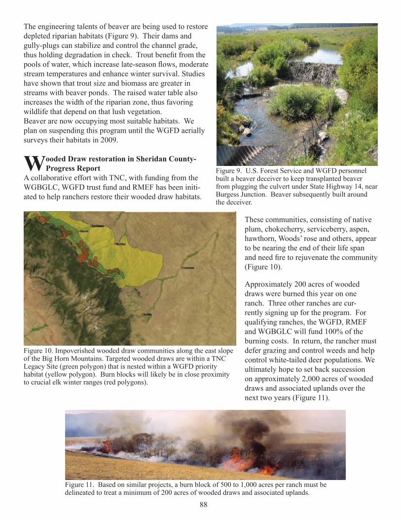
The engineering talents of beaver are being used to restore depleted riparian habitats (Figure 9). Their dams and gully-plugs can stabilize and control the channel grade, thus holding degradation in check. Trout benefi t from the pools of water, which increase late-season fl ows, moderate stream temperatures and enhance winter survival. Studies have shown that trout size and biomass are greater in streams with beaver ponds. The raised water table also increases the width of the riparian zone, thus favoring wildlife that depend on that lush vegetation.Beaver are now occupying most suitable habitats. We plan on suspending this program until the WGFD aerially surveys their habitats in 2009.
Wooded Draw restoration in Sheridan County- Progress Report
A collaborative effort with TNC, with funding from the WGBGLC, WGFD trust fund and RMEF has been initi-ated to help ranchers restore their wooded draw habitats.
These communities, consisting of native plum, chokecherry, serviceberry, aspen, hawthorn, Woods’ rose and others, appear to be nearing the end of their life span and need fi re to rejuvenate the community (Figure 10).
Approximately 200 acres of wooded draws were burned this year on one ranch. Three other ranches are cur-rently signing up for the program. For qualifying ranches, the WGFD, RMEF and WGBGLC will fund 100% of the burning costs. In return, the rancher must defer grazing and control weeds and help control white-tailed deer populations. We ultimately hope to set back succession on approximately 2,000 acres of wooded draws and associated uplands over the next two years (Figure 11).
Figure 9. U.S. Forest Service and WGFD personnel built a beaver deceiver to keep transplanted beaver from plugging the culvert under State Highway 14, near Burgess Junction. Beaver subsequently built around the deceiver.
Figure 10. Impoverished wooded draw communities along the east slope of the Big Horn Mountains. Targeted wooded draws are within a TNC Legacy Site (green polygon) that is nested within a WGFD priority habitat (yellow polygon). Burn blocks will likely be in close proximity to crucial elk winter ranges (red polygons).
Figure 11. Based on similar projects, a burn block of 500 to 1,000 acres per ranch must be delineated to treat a minimum of 200 acres of wooded draws and associated uplands.

89
Wooded draws provide key habitat for nearly all wildlife species living in the Northern Great Plains. For white-tailed and mule deer, these draws provide fawning habitat, escape cover and browse. Studies indicate that deer spend over half their time in this habitat type. Wooded draws are also important to wild turkey, sharp-tailed grouse, pheasants and numerous other birds and mammals.
Response of prairie stream riparian buffers to livestock exclusion and short-duration grazing in northeast Wyoming - Final Report
Eleven riparian buffer strips were monitored via “before and after” pictures in Sheridan and Johnson Counties. The NRCS, WGFD and conservation districts worked with landowners to enroll riparian habitats in the Farm Service Agency’s CRP continuous sign-up. Under this program, the Farm Service Agency provides participants with annual rental payments and cost-share assistance. Many of these CRP buffers are half way through their 15-year exclusion of livestock. The restoration of these prairie stream habitats has been nothing short of remark-able.
To document the changes and educate the public about the benefi ts associated with livestock grazing management in riparian habitats, we prepared and posted the report titled Response of Prairie Stream Riparian Buffers to Livestock Exclusion and Short-Duration Grazing in Northeast Wyoming-A Pre- and Post- Photographic Comparison (Figure 12). It can be viewed by navigating to: http://gf.state.wy.us/habitat/Riparian/RiparianBuffer_Rept_Final.pdf. This document has gained national attention. In addition to the WGFD web page, it’s also posted and referenced on Wyoming and Montana NRCS sites. From this report, we wrote a short article for Wyoming Wildlife magazine and created a poster-board display that can be used at conferences and workshops.
Fish Passage at Low-Head Diversion Dams (Developing Design Guidelines for Low Head Fish Friendly Diversion Dams)
A cooperative effort with the NRCS and BOR continued during 2007. The goals were to assess what fi sh species were moving in Clear Creek, their ability to move past a stepped cross vane structure at the Frank Hopkins diversion (Figure 13), and develop design guidance for how cross vane structures could be built to better accommodate upstream fi sh passage. In turn, the guidance will be distributed to agency resource managers, consultants, and landowners considering rehabilitation ef-forts at stream diversion. The efforts will continue in 2008.
Figure 12. This 32-page report contains over 60 pre- and post- photographic comparisons of riparian buffers where livestock have been excluded or dramatically reduced.
Figure 13. The stepped cross vane diversion structure at the Frank Hopkins diversion on Clear Creek.

90
Interstate Diversion Dam Fish PassageThe Interstate Diversion at the Welch Ranch property limits or completely blocks migratory sauger and
channel catfi sh from reaching up to 26-miles of the Tongue River and 12-miles of Goose Creek (Figures 14 and 15). Establishing dependable fi sh passage at the dam would make suitable habitats available for these species in segments of both streams.
Fisheries personnel used electrofi shing to search for sauger and channel catfi sh in the Tongue River below the Interstate Diversion dam on several occasions in June 2007. High fl ows and poor electrofi shing effectiveness prevented search efforts in May, and limited the effectiveness of June efforts. No sauger or channel catfi sh were found, though both were found in 2006. No surveys occurred above the dam in 2007, because neither sauger nor channel catfi sh were found there in 2006. Flows were considerably higher in spring 2007 than in 2006. Therefore, it is conceivable sauger may have passed the dam at one or both edges of the dam during high fl ows. It is less likely channel catfi sh would be able to pass the dam at high fl ows.
Efforts to document the presence or absence, and relative abundance of sauger and channel catfi sh in the Tongue River below and above the Interstate Diversion Dam will continue in 2008. Discussions will continue with the ditch company relative to establishing fi sh passage at the dam with the goal of establishing a win-win scenario.
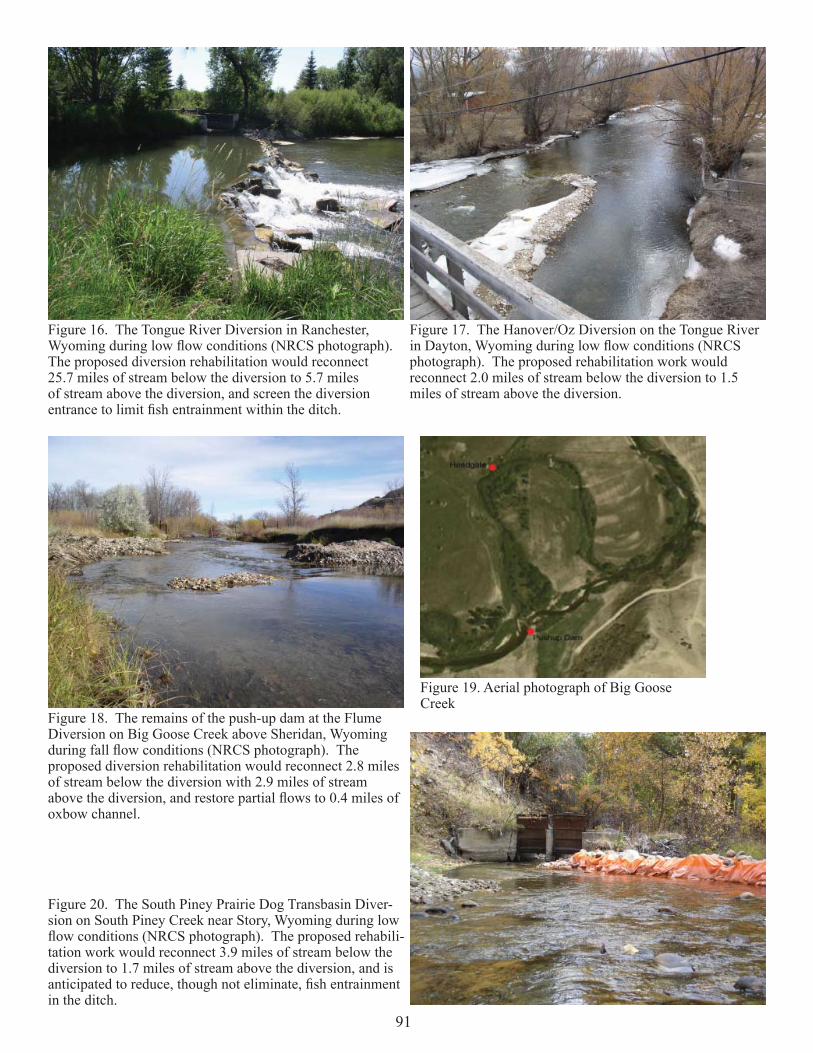
Sheridan County Conservation District Diversion Rehabilitation A funding partnership was initiated with the Sheridan County Conservation District (SCCD) and NRCS
to cost share on a series of diversion rehabilitation projects in Sheridan County. Four diversions have been targeted for rehabilitation efforts. Two occur on the Tongue River (Figures 16 and 17), one on Big Goose Creek (Figures 18 and 19), and one on South Piney Creek (Figure 20). The purpose is to restore fi sh movements past irrigation diversion dams, limit game and nongame fi sh loss within the diversions, and enhance stream channel stability at the diversion sites while addressing the operational and maintenance needs of the diversion opera-tors. Several game and nongame fi sh would benefi t from the proposed work. Cost share funding for the proj-ects was sought from Department administered fi sh passage program funding. Implementation is anticipated in 2008 pending adequate cost-share funding from multiple sources.
Figure 14. Stream segments on the Tongue River and Goose Creek depicted in red could be made available to sauger and channel catfi sh by implementing a passage project at the Inter-state Diversion Dam.
Figure 15. Interstate Diversion Dam
91
Figure 16. The Tongue River Diversion in Ranchester, Wyoming during low fl ow conditions (NRCS photograph). The proposed diversion rehabilitation would reconnect 25.7 miles of stream below the diversion to 5.7 miles of stream above the diversion, and screen the diversion entrance to limit fi sh entrainment within the ditch.
Figure 17. The Hanover/Oz Diversion on the Tongue River in Dayton, Wyoming during low fl ow conditions (NRCS photograph). The proposed rehabilitation work would reconnect 2.0 miles of stream below the diversion to 1.5 miles of stream above the diversion.
Figure 18. The remains of the push-up dam at the Flume Diversion on Big Goose Creek above Sheridan, Wyoming during fall fl ow conditions (NRCS photograph). The proposed diversion rehabilitation would reconnect 2.8 miles of stream below the diversion with 2.9 miles of stream above the diversion, and restore partial fl ows to 0.4 miles of oxbow channel.
Figure 19. Aerial photograph of Big Goose Creek
Figure 20. The South Piney Prairie Dog Transbasin Diver-sion on South Piney Creek near Story, Wyoming during low fl ow conditions (NRCS photograph). The proposed rehabili-tation work would reconnect 3.9 miles of stream below the diversion to 1.7 miles of stream above the diversion, and is anticipated to reduce, though not eliminate, fi sh entrainment in the ditch.

92
Bighorn National Forest Stream RehabilitationFunding through the WGFD Wildlife Trust Fund was
provided to the Bighorn National Forest to cost-share on phase-2 of the stream rehabilitation project at the Boy Scout reach of the South Tongue River (Figure 21). Phase-2 entails procuring and stockpiling all necessary rock for the stream rehabilitation project at the project sites. Additional cost-share funding was procured by the Forest from the WWNRT. The Forest intends to complete the phase-2 efforts in 2008. Concurrently, the Forest will begin exploring cost-share options for the phase-3 implementation efforts.
Lake DeSmet Conservation District Clear Creek Stream Rehabilitation
Stream rehabilitation projects were previously completed by the LDCD at two reaches of Clear Creek within Buffalo. Re-habilitation occurred at the phase-1 reach within the Buffalo City Park in 2005 and the phase-2 reach behind the County Shop in 2006. The Department provided cost-share assistance with the implementation of both phases through the WGFD Wildlife Trust Fund. The objectives were to in-crease pools, stabilize point bars, protect streambanks, increase fl oodplain connectivity with bankfull benches at strategic locations, narrow the channel, maintain sediment transport and substrate sorting, and concentrate fl ows in multistage channel segments to increase cover available for trout during low fl ow periods. Assessments were completed at both reaches to monitor the effect of the work on stream conditions and trout cover.
The phase-1 rehabilitation project increased cover from 12- to 20-percent based on comparisons between 2005 pre-rehabilitation and 2007 post-rehabilitation assessments. Meanwhile, poorly vegetated or eroding streambanks increased from 10- to 19-percent between 2006 and 2007 due to a combination of heavy path development and the lack of adequate vegetation establishment on a constructed bankfull bench. Further, the work reduced wetted channel width from 31.8 feet (n = 11, range = 18.6 – 44.0 feet) to 29.8 feet (n = 11, range = 19.6 – 40.1 feet) between the 2005 and 2007 assessments while fl ow was more than double in the channel during the 2007 assessment (4.2 cfs vs. 11.4 cfs). Some of the reduction in width is attributed to the develop-ment of low fl ow channel segments within the bankfull channel (Figure 22). Residual pool depths increased from 1.1 feet (n = 2, range = 0.9 – 1.3 feet) in 2005 to 1.4 feet (n = 6, range = 0.9 – 2.0 feet) in 2007.
Figure 21. Aerial overview depicting stream pattern at the Boy Scout stream rehabilitation reach along the South Tongue River.
Figure 22. Clear Creek within the phase-1 (Buffalo City Park) stream rehabilitation reach during fall fl ow conditions. A multi-stage channel (low fl ow channel nested within the main channel) was created to narrow stream widths and increase cover available for trout during low fl ow conditions.

93
The phase-2 rehabilitation project increased cover from 11- to 13-percent and reduced poorly vegetated or eroding streambanks from 33- to 22-percent. The work reduced wetted channel width from 29.2 feet (n = 11, range = 12.9 – 40.6 feet) in 2006 to 27.7 feet (n = 11, range = 21.0 – 34.3 feet) in 2007 while fl ow during the 2007 assessment was more than triple that of the 2006 assessment (3.3 cfs vs. 11.3 cfs). Again, some of the width reduction is attributed to the development of multi-stage low fl ow channel segments within the bankfull channel. Residual pool depths increased from 1.1 feet (n = 2, range = 1.0 – 1.1 feet) in 2006 to 2.2 feet (n = 3, range = 1.7 – 2.4 feet) in 2007. One natural lateral scour pool with overhanging shrubs was lost within the assessment reach, but replaced with several mid channel pools with no vegetation infl uence.
Black Hills National Forest Beaver Transplants and Monitoring
Beaver transplants were sought in the Beaver Dam Creek watershed on the Bear Lodge Mountain Range of the Black Hills National Forest to enhance riparian water storage (Figure 23). Unfortunately, local beaver supplies were inadequate to satisfy transplants requirements. Transplants to headwater watersheds on the Forest will be considered in the future pending resolution of the beaver supply issue and ap-proval of funding to pay a trapper to live-trap beaver.
Powder River and Crazy Woman Creek Baseline Habitat Surveys
Flow and habitat unit transect assessments were completed at the Above Salt Creek, Below Salt Creek, Above Pumpkin Creek, Below Burger Draw, Above Crazy Woman, Below Crazy Woman, Above Clear Creek, and Below Clear Creek inventory reaches on the Powder River, and the Upper and Lower inventory reaches of Crazy Woman Creek. The habitat unit transect assessments included wetted width, depth, substrate composition, and habitat unit composi-tion assessments (Figure 24). These assessments compliment the 2006 habitat unit transect assessments that were completed at the inventory reaches when either surface fl ow was low, or the stream was pooled. Data are on fi le at the Sheridan Regional Offi ce. More comprehensive reporting on these assessments will occur in the future.
Figure 23. Dam complex on the Black Hills National Forest where beaver, through their dam-building activities, have raised the riparian water table. The increased water storage in the streambanks moderates late season fl ows. Thus, precipitation runoff from snow melt and rainfall events are slowed and retained on the land longer, and in turn, released from the riparian water table more slowly rather than coursing through the stream system quickly.
Figure 24. Collecting wetted width, depth, substrate size, and habitat type information at one of 30 transects completed at the Below Clear Creek study reach of the Powder River. Thirty- to 32-transects were completed at each of the eight 2-mile monitoring reaches on the Powder River, and 11 transects were completed at both of the shorter monitoring reaches on Crazy Woman Creek.
94
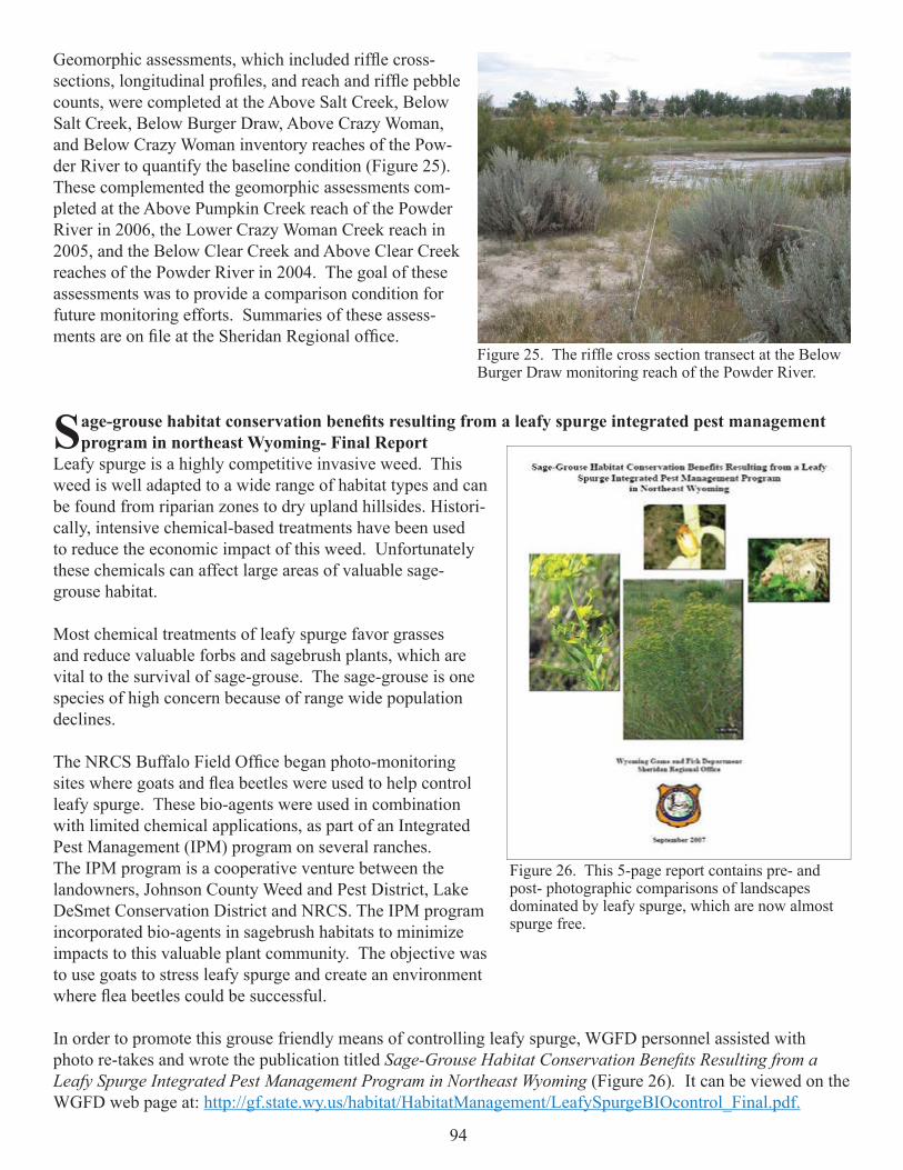
Geomorphic assessments, which included riffl e cross-sections, longitudinal profi les, and reach and riffl e pebble counts, were completed at the Above Salt Creek, Below Salt Creek, Below Burger Draw, Above Crazy Woman, and Below Crazy Woman inventory reaches of the Pow-der River to quantify the baseline condition (Figure 25). These complemented the geomorphic assessments com-pleted at the Above Pumpkin Creek reach of the Powder River in 2006, the Lower Crazy Woman Creek reach in 2005, and the Below Clear Creek and Above Clear Creek reaches of the Powder River in 2004. The goal of these assessments was to provide a comparison condition for future monitoring efforts. Summaries of these assess-ments are on fi le at the Sheridan Regional offi ce.
Sage-grouse habitat conservation benefi ts resulting from a leafy spurge integrated pest management program in northeast Wyoming- Final Report
Leafy spurge is a highly competitive invasive weed. This weed is well adapted to a wide range of habitat types and can be found from riparian zones to dry upland hillsides. Histori-cally, intensive chemical-based treatments have been used to reduce the economic impact of this weed. Unfortunately these chemicals can affect large areas of valuable sage-grouse habitat.
Most chemical treatments of leafy spurge favor grasses and reduce valuable forbs and sagebrush plants, which are vital to the survival of sage-grouse. The sage-grouse is one species of high concern because of range wide population declines.
The NRCS Buffalo Field Offi ce began photo-monitoring sites where goats and fl ea beetles were used to help control leafy spurge. These bio-agents were used in combination with limited chemical applications, as part of an Integrated Pest Management (IPM) program on several ranches. The IPM program is a cooperative venture between the landowners, Johnson County Weed and Pest District, Lake DeSmet Conservation District and NRCS. The IPM program incorporated bio-agents in sagebrush habitats to minimize impacts to this valuable plant community. The objective was to use goats to stress leafy spurge and create an environment where fl ea beetles could be successful.
In order to promote this grouse friendly means of controlling leafy spurge, WGFD personnel assisted with photo re-takes and wrote the publication titled Sage-Grouse Habitat Conservation Benefi ts Resulting from a Leafy Spurge Integrated Pest Management Program in Northeast Wyoming (Figure 26). It can be viewed on the WGFD web page at: http://gf.state.wy.us/habitat/HabitatManagement/LeafySpurgeBIOcontrol_Final.pdf.
Figure 25. The riffl e cross section transect at the Below Burger Draw monitoring reach of the Powder River.
Figure 26. This 5-page report contains pre- and post- photographic comparisons of landscapes dominated by leafy spurge, which are now almost spurge free.

95
HABITAT EXTENSION SERVICES
Wild Horse Creek Riparian Exclosure and Oxbow Restoration A total of 71 acres will be rested from grazing for 15
years in order to improve hydrologic function, and riparian vegetation condition utilizing the CCRP through USDA. The landowners have noticed a reduction in willows and cot-tonwood regeneration and would like to see this trend reversed. Willows and cottonwoods will be planted within the riparian exclosure. In the past the stream was diverted into a new straightened channel in order to create a small hayfi eld dewa-tering an oxbow area. We are currently working on engineering plans to re-divert the stream back into the old oxbow. This will decrease the stream energy, decrease stream erosion and increase the amount of riparian area. Woody vegetation along the oxbow should also benefi t. The oxbow and surrounding area is an important great blue heron rookery (Figure 27). Because many of the cottonwoods are old and many are dying, cottonwood regeneration will be critical to the maintenance of the rookery.
Inyan Kara Creek Riparian ExclosureIn order to improve wildlife cover a 13 acre riparian area
will be rested from grazing for 15 years with use of the CCRP program (Figure 28). Whitetail deer numbers are high in the area so we started with a small exclosure to determine if the heavy utilization of woody vegetation will be improved by removing livestock. Five small wildlife exclosures were also set up to prevent browsing on different woody plant species. If growth of woody plants is improved the CCRP will be expanded. Willows, cottonwoods, and box elder will be planted within the CCRP. The land-owner is interested in developing a 10 acre wetland through the wetland reserve program within the next 1 to 2 years.
Figure 27. Location of oxbow project and CCRP on Wild Horse Creek.
Figure 28. Inyan Kara creek continuous Conservation Reserve.
96
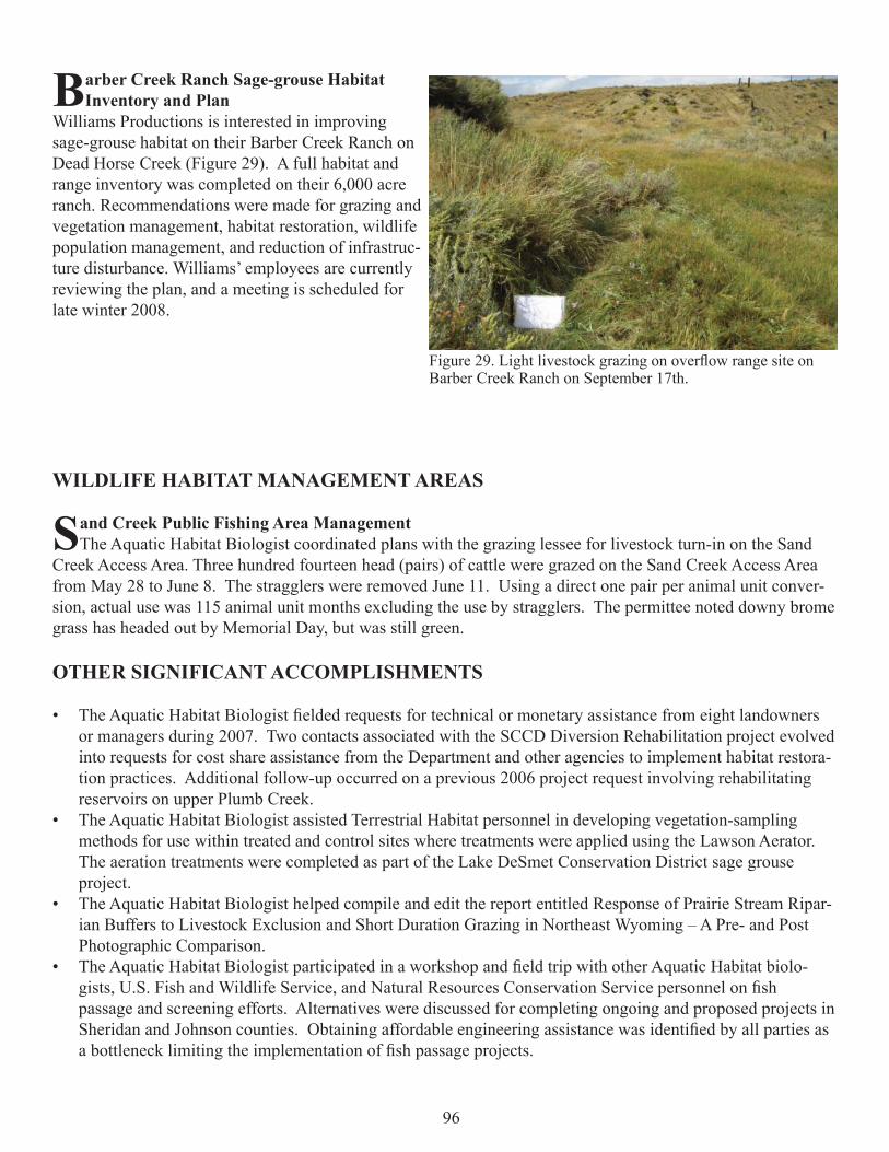
Barber Creek Ranch Sage-grouse Habitat Inventory and Plan
Williams Productions is interested in improving sage-grouse habitat on their Barber Creek Ranch on Dead Horse Creek (Figure 29). A full habitat and range inventory was completed on their 6,000 acre ranch. Recommendations were made for grazing and vegetation management, habitat restoration, wildlife population management, and reduction of infrastruc-ture disturbance. Williams’ employees are currently reviewing the plan, and a meeting is scheduled for late winter 2008.
WILDLIFE HABITAT MANAGEMENT AREAS
Sand Creek Public Fishing Area ManagementThe Aquatic Habitat Biologist coordinated plans with the grazing lessee for livestock turn-in on the Sand
Creek Access Area. Three hundred fourteen head (pairs) of cattle were grazed on the Sand Creek Access Area from May 28 to June 8. The stragglers were removed June 11. Using a direct one pair per animal unit conver-sion, actual use was 115 animal unit months excluding the use by stragglers. The permittee noted downy brome grass has headed out by Memorial Day, but was still green.
OTHER SIGNIFICANT ACCOMPLISHMENTS
The Aquatic Habitat Biologist fi elded requests for technical or monetary assistance from eight landowners • or managers during 2007. Two contacts associated with the SCCD Diversion Rehabilitation project evolved into requests for cost share assistance from the Department and other agencies to implement habitat restora-tion practices. Additional follow-up occurred on a previous 2006 project request involving rehabilitating reservoirs on upper Plumb Creek.The Aquatic Habitat Biologist assisted Terrestrial Habitat personnel in developing vegetation-sampling • methods for use within treated and control sites where treatments were applied using the Lawson Aerator. The aeration treatments were completed as part of the Lake DeSmet Conservation District sage grouse project.The Aquatic Habitat Biologist helped compile and edit the report entitled Response of Prairie Stream Ripar-• ian Buffers to Livestock Exclusion and Short Duration Grazing in Northeast Wyoming – A Pre- and Post Photographic Comparison. The Aquatic Habitat Biologist participated in a workshop and fi eld trip with other Aquatic Habitat biolo-• gists, U.S. Fish and Wildlife Service, and Natural Resources Conservation Service personnel on fi sh passage and screening efforts. Alternatives were discussed for completing ongoing and proposed projects in Sheridan and Johnson counties. Obtaining affordable engineering assistance was identifi ed by all parties as a bottleneck limiting the implementation of fi sh passage projects.
Figure 29. Light livestock grazing on overfl ow range site on Barber Creek Ranch on September 17th.

97
The Aquatic Habitat Biologist participated on an interagency working group charged with developing • a watershed management plan to address the E-coli impaired segment of the North Tongue River. The Bighorn National Forest is the lead for the working group.The Aquatic Habitat Biologist assisted a University of Wyoming graduate student working on the Powder • River to identify study sites and initiate GPS mapping efforts.Organized a sage-grouse habitat grazing management workshop for local landowners. Five landowners • attended the workshop. Received $ 5,000 from North East Wyoming Sage-grouse Work Group and $1,000 from Campbell County • conservation District for 3 additional sage-grouse habitat grazing management workshops with Roy Roath to be held in June 2008 and 3 days working with interested land owners on grazing management plans.Wrote and presented Wyoming State Acres for Wildlife proposal for sagebrush habitat.• Set up protocol and began collecting mule deer fecal samples for diet analysis in Little Powder, Powder and • Little Black Thunder drainages.Participating on a committee consisting of wildlife and rangeland science experts form Wyoming, Colorado, • Montana, Utah and Idaho to develop a literature synthesis that would ultimately be used to develop livestock grazing “best management practices” for sage-grouse habitats.Participating on a committee of sage-grouse and remote sensing experts to develop protocol for mapping • habitats and modeling for potential sage-grouse occurrence in the state. This assignment originated from the Governor’s Sage-Grouse Implementation Team. Coauthoring the Energy and Mineral Development Chapter of the Western Association of Fish and Wildlife • Agencies Mule Deer Habitat Guidelines for the Great Plains Ecosystem.Working with the BLM National Science Center to provide data and recommendations for their effort to • map sage-grouse habitats and determine connectivity issues in Wyoming. Other assignments involved the WGFD Sheridan Region. They include: • Working towards developing sage-grouse habitat mapping protocol for the Powder River Basin. Techniques • for course, mid and fi ne-scale mapping were formulated by working with sage-grouse researchers and experts, as well as reviewing existing documents. Helping the Rocky Mountain Elk Foundation’s Wyoming fi eld director with mapping and wildlife assess-• ments for properties being proposed for purchase and conservations easements. Attending a USFS tour/meeting to inspect and discuss over-browsing of willow and aspen resources within • the Bighorn National Forest’s Tongue River watershed. Serving on The Nature Conservancy’s Northeast Wyoming Program advisory board. • Assisting twelve livestock producers and two consultants (working on local ranches) to help with their • wildlife habitat enhancement efforts, funding and management strategies to benefi t wildlife.