032 - fall 1994-winter 1995
TRANSCRIPT
32 C i t e 3 2 1 9 9 5
DOWNTOWN
Main Street looking north from Preston Avenue. 1858
1836- The Allen 8mthers'Plan The Main Street spine is balanced midway along its six-block extent by two public squares. Market Square to the west and Court House Square to the east. At the south edge of town, facing what would become Texas Avenue, two half-squares are set aside for high-minded pursuits; a church reserve and a school reserve.
1837-1865 Main Street is the spine Main at Franklin is the center of downtown. At the foot of Main Street is the wharf. Connected directly to it are warehous-es and wholesale houses. Retail busi-nesses are located on the three blocks of Mam between Commerce and Preston, occupying the first generation of brick business houses, which begin to be built in the mid-1840s. These spill over to the west to surround Market Square There is only limited commer-cial incursion around Court House Square, which is chiefly residential. The church and school reserves on Texas Avenue both become the site of churches
1865-1890 At the foot of Mam Street, extending up to Commerce Avenue and stretching between Milam on the west and Caroline on the east, is the wharf, warehouse, and wholesale district. Railroad development keeps to the north side of Buffalo Bayou and east of downtown. Therefore, railroad tracks and the development associated with them (warehouses, industry, and work-ing-class residential neighborhoods) do not penetrate downtown Market Square is rebuilt with new brick build-ings to serve the food trades Two elaborate City Hall-Market Houses are constructed, one after the other, on Market Square The center of down-town remains the intersection of Mam and Franklin, which becomes the cor-ner where Houston's first banks clus-ter. Two- and three-story brick buildings replace the earlier generation of commercial buildings A retail shop-ping district emerges along Main between Congress and Prairie avenues. Dwelling houses built in the 1830s and 1840s near Main and Prairie are demol-ished for replacement by new business buildings. Construction of the Capitol Hotel in 18B3 (eventually the Rice Hotel) marks Texas Avenue as the upper end of the Main Street business district. South of Lamar Avenue, Main becomes the Victorian grand avenue of Houston, the town's most fashionable residential street. The introduction of mule-drawn streetcars and efforts to pave Main Street make downtown easier to get to and easy lo move about in.
Main Street looking soulli from Franklin Avenue, 1894.
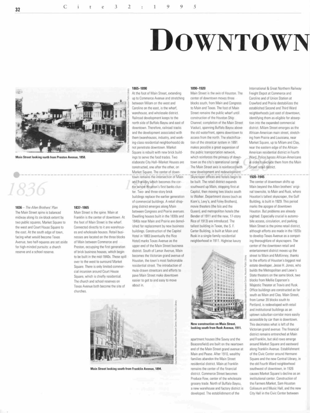
1890-1920 Main Street is the axis of Houston, The center of downtown moves three blocks south, Irom Main and Congress to Main and Texas. The fool of Mam Street remains the public wharf until construction ol the Houston Ship Channel; completion of the Mam Street Viaduct, spanning Buffalo Bayou above the old waterfront, opens downtown to access from the north. The electrifica-tion of the streetcar system in 1891 makes possible a great expansion of the public transportation network, which reinforces the primacy of down-town as the city's operational center The Main Street axis is reinforced with new development and redevelopment. Skyscraper offices and hotels begin to be built. The retail district expands southward up Main, stopping first at Capitol, then moving two blocks south to Walker. Department stores Isuch as Kiam's, Levy's, and Foley Brothers), movie theaters (the Isis and the Queen), and metropolitan hotels (the Benderof1911andthenew.17-story Rice of 1913) are introduced. The tallest building in Texas, the S. F. Carter Building, is built at Main and Rusk in a single-lamily residential neighborhood in 1911. Highrise luxury
S!'i« ^ * Hi
i
New construction on Main Street, looking south from Rusk Avenue, 1911.
apartment houses (the Savoy and the Beaconsiield) are built on the neartown end ol the Main Street grand avenue at Main and Pease After 1910, wealthy families abandon the Main Street residential district. Main at Franklin remains the center ol the financial district. Commerce Street becomes Produce Row, center of the wholesale grocery trade. North of Buffalo Bayou, a new warehouse and factory district is developed. The establishment of the
International & Great Northern Railway Freight Depot at Commerce and Caroline and of Union Station at Crawford and Prairie destabilizes the established Second and Third Ward neighborhoods just east of downtown, identifying them as eligible for absorp-tion into the expanded commercial district. Milam Street emerges as the African-American mam street, stretch-ing Irom Prairie and Louisiana, near Market Square, up to Milam and Clay, near the eastern edge of the African-American residential district in Fourth Ward. Police harass African-Americans in order to exclude them from the Main Street retail district
1920 1945 The center of downtown shifts up Main beyond the Allen brothers' origi-nal townsite, to Main and Rusk, where Houston's tallest skyscraper, the Gulf Building, is built in 1929. This period marks the apogee of downtown Houston. But problems are already sighted Especially crucial is automo-bile access, circulation, and parking. Main Street is the prime retail district, although efforts are made in the 1920s to develop Texas Avenue as a compet-ing thoroughfare of skyscrapers The center of the downtown retail and entertainment district moves up the street to Main and McKinney. thanks to the efforts of Houston's biggest real estate developer, Jesse H. Jones, who builds the Metropolitan and Loew's Slate theaters on the same block, two blocks from Mellie Esperson's Majestic Theater at Travis and Rusk. Office buildings are constructed as far south as Main and Clay. Main Street, from Lamar 39 blocks south to Portland, is redeveloped with retail and institutional buildings as an uptown suburban corridor more easily accessible by car than is downtown This decimates what is left of the Victorian grand avenue. The financial district remains entrenched at Main and Franklin, but skid rows emerge around Market Square and eastward along Franklin Avenue. Establishment of the Civic Center around Hermann Square and the new Central Library, in the old Fourth Ward neighborhood southwest of downtown, in 1926 causes Market Square's decline as an institutional center. Construction of the Farmers Market, Sam Houston Coliseum and Music Hall, and the new City Hall in the Civic Center between
C i t e 3 2 : 1 9 ^) 5 33
HOUSTON: A Timeline
S t e p h e n F o x
1929 and 1939. in conjunction with the opening ol Allen Parkway in 1926, begins to pull new development west-ward off the course of Main Street in the late 1930s. The Great Depression halts the real estate boom ol the late 1920s. Commercial construction slowly resumes in 1935. By 1937. a new boom in retail construction is under way downtown, but the skyline remains dominated by the set-back towers of the 1920s. The streetcar system is replaced by buses in the late 1930s. Public transportation remains centered on downtown, but its impact shrinks in the face of massive reliance on the automobile.
1945-1950 This marks the final episode of down-town's supremacy as the operational center of Houston Construction of the last major retail buildings in downtown - Foley's, Joske's. Battelstein's, The Fashion (later Neiman Marcus), Sakowitz Brothers, and Woolworth's -occurs. Main and Lamar is the center of downtown Houston.
i ' ^ mwm What's happened to
Main Street f * \ " " . — ' * • « 4 a k a | « i i t H f i J i M i r t i , ,h i M « M M M M
I M B W I H M M i i M M i M l u n l i M M i
f » I ' M N « H * . U r M , h M U
•Mm *.*•* St*. Houston Gas & I tn. Company
M T * . ^ W AT , « ! It' I I" . IBH '<• II
"What's Happened ID Main Street?," advertising image, 1928.
1950-1960 Downtown stagnates in the midst of Houston's biggest real estate boom. Between 1955 and 1961. Palms Center, Gulfgate, Meyerland, Northgate. and Sharpstown shopping malls are built, occupied by suburban branches of downtown stores. A new uptown hotel and highrise office district emerges adjacent to the Texas Medical Center. Only a handful of tall buildings are constructed downtown; the largest are headquarters for banks exiting the Main-Franklin financial district. Demolition of 19th- and early-20th-century commercial buildings is widespread north of Texas Avenue and on the peripheries of downtown. Cleared land is not redeveloped but used as parking lots. The prospect of crisis is imminent. The agreed-upon solution is to stabilize downtown real estate by building up the Civic Center on the west side. Sam Houston Park becomes the site of an open-air muse-um of restored 19th-century Houston buildings
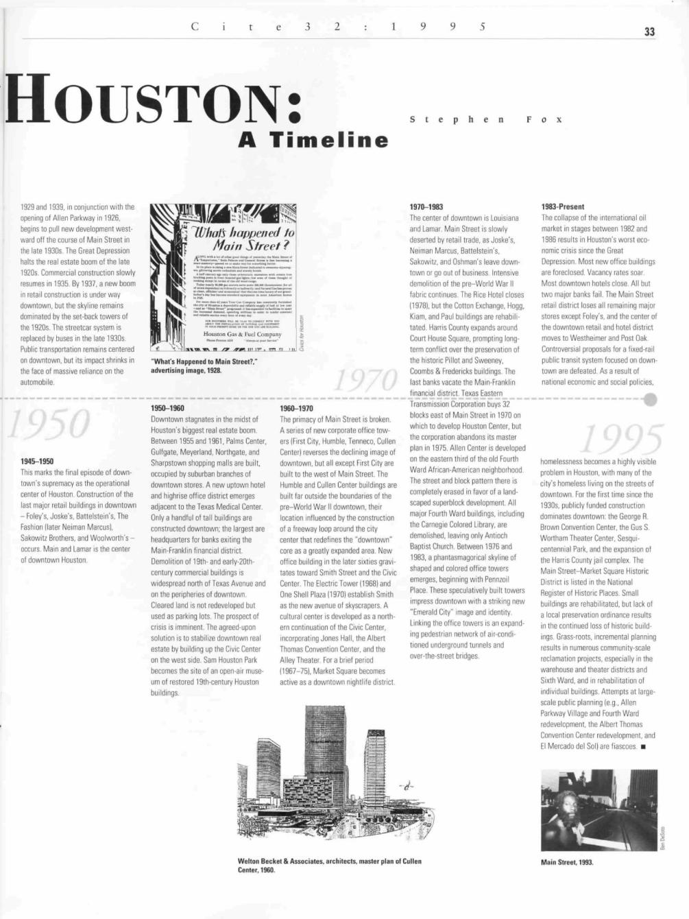
1960-1970 The primacy of Main Street is broken. A series of new corporate oflice tow-ers (First City, Humble, Tenneco, Cullen Center) reverses the declining image of downtown, but all except First City are built to the west of Main Street. The Humble and Cullen Center buildings are built far outside the boundaries of the pre-World War II downtown, their location influenced by the construction of a freeway loop around the city center that redefines the "downtown" core as a greatly expanded area. New office building in the later sixties gravi-tates toward Smith Street and the Civic Center. The Electric Tower (19681 and One Shell Plaza (19701 establish Smith as the new avenue of skyscrapers. A cultural center is developed as a north-ern continuation of the Civic Center, incorporating Jones Hall, the Albert Thomas Convention Center, and the Alley Theater For a brief period 11967-751. Market Square becomes active as a downtown nightlife district.
- - — - ^ *%>-->:.' -". £-.:
• • --•• ".:•
T£
1970-1983 The center of downtown is Louisiana and Lamar. Main Street is slowly deserted by retail trade, as Joske's, Neiman Marcus, Battelstein's, Sakowitz. and Oshman's leave down-town or go out of business. Intensive demolition of the pre-World War II fabric continues. The Rice Hotel closes (1978), but the Cotton Exchange. Hogg, Kiam, and Paul buildings are rehabili-tated. Harris County expands around Court House Square, prompting long-term conflict over the preservation of the historic Pillot and Sweeney, Coombs & Fredericks buildings The last banks vacate the Mam-Franklin financial district. Texas Eastern Transmission Corporation buys 32 blocks east of Main Street in 1970 on which to develop Houston Center, but the corporation abandons its master plan in 1975. Allen Center is developed on the eastern third of the old Fourth Ward African-American neighborhood. The street and block pattern there is completely erased in lavor of a land-scaped superblock development. All major Fourth Ward buildings, including the Carnegie Colored Library, are demolished, leaving only Antioch Baptist Church Between 1976 and 1983, a phantasmagorical skyline of shaped and colored office towers emerges, beginning with Pennzoil Place. These speculatively built towers impress downtown with a striking new "Emerald City" image and identity Linking the office towers is an expand-ing pedestrian network Df air-condi-tioned underground tunnels and over-the-street bridges.
1983-Present The collapse of the international oil market in stages between 1982 and 1986 results in Houston's worst eco-nomic crisis since the Great Depression. Most new office buildings are foreclosed. Vacancy rates soar. Most downtown hotels close All but two major banks fail. The Main Street retail district loses all remaining major stores except Foley's, and the center of the downtown retail and hotel district moves to Westheimer and Post Oak. Controversial proposals for a fixed-rail public transit system focused on down-town are defeated. As a result of national economic and social policies,
homelessness becomes a highly visible problem in Houston, with many Df the city's homeless living on the streets ol downtown. For the first time since the 1930s, publicly funded construction dominates downtown: the George R, Brown Convention Center, the Gus S Wortham Theater Center. Sesqui-centennial Park, and the expansion of the Harris County jail complex The Main Street-Market Square Historic District is listed in the National Register of Historic Places. Small buildings are rehabilitated, but lack of a local preservation ordinance results in the continued loss of historic build-ings, Grass-roots, incremental planning results in numerous community-scale reclamation projects, especially in the warehouse and theater districts and Sixth Ward, and in rehabilitation of individual buildings. Attempts at large-scale public planning (eg.. Allen Parkway Village and Fourth Ward redevelopment, the Albert Thomas Convention Center redevelopment, and El Mercado del Soil are fiascoes. •
Welton Becket & Associates, architects, master plan ol Cullen Center, 1960.
Main Street. 1993.