010 placer dome canada project 413 - mckenzie island
TRANSCRIPT
52N04SW0075 2 165S8 TOME
010
PLACER DOME CANADA
PROJECT 413 - MCKENZIE ISLAND PROPERTY
GEOLOGICAL REPORT -1994 WORK PROGRAMME
DOME TOWNSHIP, ONTARIO
NTS: 52/N/4
MAY 1996 STUART W. DEVEAU

52N04SW0075 2.16558 DOME
TABLE OF CONTENTS
01OC
SUMMARY AND CONCLUSIONSINTRODUCTIONPROPERTYLOCATION AND ACCESSPREVIOUS WORKGENERAL GEOLOGYPROPERTY GEOLOGYMINERALIZATIONSTRUCTURETRENCHED AND STRIPPED AREAROCK GEOCHEMISTRYRECOMMENDATIONSREFERENCESCERTIFICATE OF QUALIFICATIONS
Pagel l l 3 3 5 5 7 7 7
10101113
FIGURE l FIGURE 2 FIGURES FIGURE 4 FIGURES
FIGURES
Location MapClaim MapGeneral Geology MapDetailed Maps of Trenched Area: Trench A and BDetailed Maps of Trenched Area: Trench C
24689
TABLE l TABLE 2
TABLES
Rock Types Anomalous Au Values
510
APPENDIX l APPENDIX II APPENDIX III
APPENDICES
Sample DescriptionsAnalysesList of Personnel
DRAWING l DRAWING 2
DRAWINGS (in back pocket)
Geology MapDetailed Geology Map of Trenched and Stripped Area
PLACER DOME CANADA
PROJECT 413E - MCKENZIE ISLAND PROPERTY
GEOLOGICAL REPORT 1994 WORK PROGRAMME
DOME TOWNSHIP, ONTARIO
SUMMARY AND CONCLUSIONS
Preliminary mapping and sampling of the McKenzie Island Property (MIP) defined the
lithology of the area (felsic to intermediate flows and tuffs) and located areas of previous stripping
and trenching on the east side of the property. Anomalous gold (Au) values from assays were
returned from a 20 cm quartz vein (containing pyrite, arsenopyrite and chalcopyrite) and silicified
intermediate to felsic volcanic rocks Detailed mapping of the trenches revealed that anomalous Au
assay values come from silicified felsic volcanic tuffs and flows containing disseminated pyrite
In conclusion, the 1994 work programme indicated that the area is underlain by felsic to
intermediate flows and tuffs and that anomalous Au values from assays come from a narrow quartz
vein and silicified felsic tuffs. Extensions of the quartz veins and silicified zone could be examined
by future mechanical stripping and/or diamond drilling.
INTRODUCTION
The MIP (unpatented claim #KRL 1184170) is located on the west side of McKenzie Island
in Dome Township, Red Lake Mining Division (Fig. 1). Between August 9 and September 25, 1994
(total of 10 person-days), a mapping and sampling programme was carried out by Placer Dome
Canada Limited (PDC) to evaluate the property. A previous grid (baseline oriented at 065 0, lines
spaced at 100m) was utilized during the fieldwork. Previous stripped and trenched areas were
located, mapped and sampled, five anomalous Au values were returned from assays.
PROPERTY
The MD* consists of one unpatented claim (KRL 1184170) composed of two 16-hectare claim
units in Dome Township, Red Lake Mining Division. It was recorded by PDC on August 8, 1994.

-2-
Figure 1: Location map.

-3-
LOCATION AND ACCESS
The property is located on the west side of McKenzie Island, Dome Township, Ontario,
between latitudes 51 0 04'10" and 51 0 04'28" and longitudes 93 0 51'12" and 93 0 51'32", NTS 52 N/4.
Depending on the season, access can be made either via boat or snow machine to the west shore of
the island followed by a 100m traverse to the northern boundary of the claim (Fig. 2). Access can
also be made via numerous cross-country ski trails which cut through the property.
PREVIOUS WORK
The first recorded work in the area was done by South McKenzie Island Mines Limited and
consisted of a programme of stripping, trenching and diamond drilling (5 holes totalling 185m) No
work was recorded on the property until 1980 when Gold Fields Resources Ltd. staked the area and
performed a programme of geological mapping, magnetometer and V.L.F. surveys in 1981 (Cameron,
1981, Boniwell, 1981; Chute, 1982), as well as detailed IP. surveys, a geochemical humus sampling
survey in 1982 (Seara, 1983; Bald and Cameron, 1983) and power stripping in 1983 (Cameron,
1983)
In August 1986, Dighemra airborne magnetic and electromagnetic surveys were carried out
over the property by Noramco Explorations Inc. (Smith, 1986) Pure Gold Resources Ltd. conducted
geological field work in the area during the fall of 1986 (Rusk, 1986). Their work examined the
known showing in the east-central part of the property and enlarged upon the known associated zone
of silicification.
During February 1987, Noramco Explorations, Inc., the operator for Pure Gold Resources
Ltd , conducted 388.8m of diamond drilling on the property (Donaldson, 1987). The highest Au
values were reported from a felsic tuff unit (600 ppb Au).

MCKENZIE
ISLAND
Kilometres
Figure Z: Location of Claim KRL 1184170 in relation to past producers (shown as K

-5-
GENERAL GEOLOGY
The MIP lies within the east-west trending Red Lake greenstone belt of the Uchi Subprovince
of the Archean Superior Province of the Canadian Shield. In the Red Lake area, the belt consists
mainly of volcanic rocks with lesser amounts of clastic sedimentary rocks and is bounded on all sides
by large granitic batholiths (Fig 3).
PROPERTY GEOLOGY
The property is underlain by felsic metavolcanics (tuff, crystal tuff and agglomerate), minor
intermediate to felsic metavolcanics (tuff and flow) and quartz-feldspar porphyry (Dwg. l). Bedding
is oriented northeast (NE) to southeast (SE) and is steeply dipping variably to the north and south
Quartz veining in the stripped and trenched area (Dwg. 2) is orientated at 060 0 and ranges from a few
centimetres to 20 centimetres in width.
TABLE l
Rock Types
Rock Code Rock Type
4 - INTERMEDIATE TO FELSIC METAVOLCANICS 4a - Intermediate Flow 4b - Intermediate Tuff
5 - FELSIC METAVOLCANICS5b - Felsic Tuff (variably containing pyrite and arsenopyrite) 5d - Felsic Crystal Tuff (containing pyrite, arsenopyrite and
chalcopyrite) 5e - Felsic Agglomerate
12 - MINOR FELSIC INTRUSIVES 12C - Quartz-Feldspar Porphyry

LITTLE VERMILION LAKE BATHOLITH•t- — -i- — -t- -r
Felsic plutonic 4 intrusive rocks
Mafic intrusive rocks
THOLEimC-KOMATIITlC SEQUENCE
U-Pb zircon age|x-:::: : ::v: Metasedimentary rocks
•- Chemical sediments ""-V/cj Mafic volcanic rocksi'.i j i j'l Felsic metavolcanic rocks CALC-ALKAL1NE SEQUENCE
Intermediate metavolcanic rocks :-——-—- Felsic metavolcanic rocks- -~ ~
* —
HAMMELL LAKE. BATHOLITH -t-
KILLALA-BAIRD BATHOLITH
- -t- -r
-r -i- - -t- -1- J- -i- -T- -r
o\
Figure 3 : General geology of the Red Lake greenstone belt (from Andrews et al., 1986).
-7-
MINERALIZATION
Finely disseminated pyrite is present in numerous outcrops throughout the property. In the
stripped and trenched area, disseminated pyrite and arsenopyrite occurs in the felsic tuff, and pyrite,
arsenopyrite and chalcopyrite are associated with the quartz veining. Anomalous gold values were
defined in the quartz vein as well as the silicified zone associated with the quartz veining.
STRUCTURE
The rocks outcropping on the property are relatively undeformed with the exception of the
stripped and trenched areas. Bedding in the felsic volcanics varies from 022 0 to 085 0 azimuth
dipping northwest at 48 0 to 90". Near the stripped and trenched areas, the rocks begin to display
deformation with the development of: a) foliation which varies from 045 c to 090 0 azimuth, dipping
steeply northwest to vertical; b) fracture sets at 025/60 SE and 105/65 SW, 040/60 NW and 110/58
NE, 040/78 NW and 092/77 NE, and c) shear zones at 040/68 NW and 035/74 NW The fracture
patterns noted are similar to those developed in the McKenzie Red Lake Mine to the southeast and
the Gold Eagle Mine to the east (Horwood, 1940).
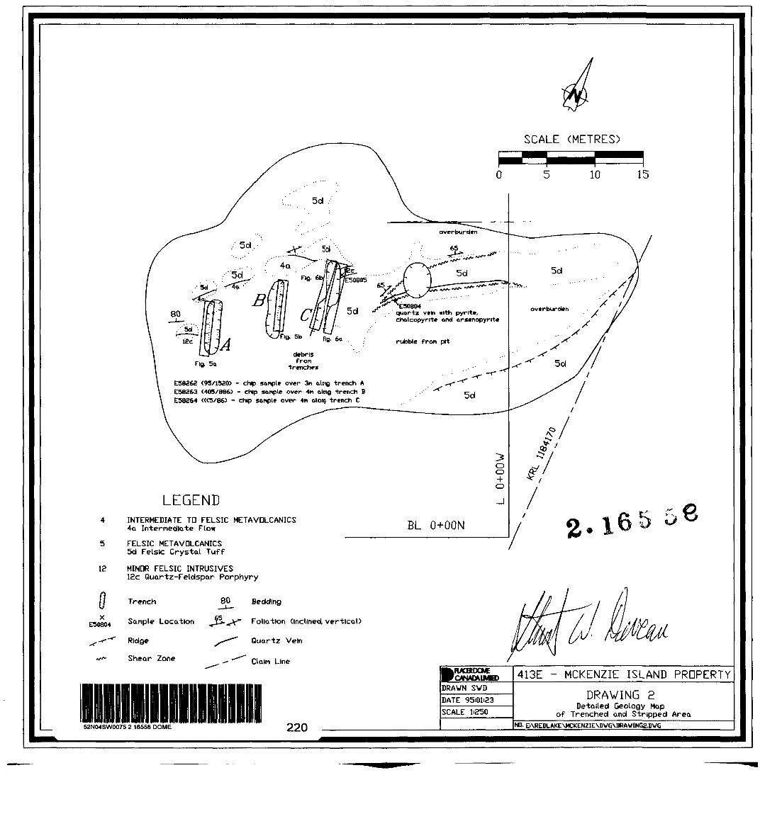
TRENCHED AND STRIPPED AREA
An area of previous stripping and trenching located 200m south of Post #1, between O and
65m west of the east boundary of claim #KRL 1184170 was examined in detail and a l :250 scale map
was produced (Dwg. 2). Cross-sections (l :50 scale) of three of the trenches were also produced
(Figs. 4 and 5). The rocks in this area consist of silicified felsic volcanics, intermediate volcanic flow
and quartz-feldspar-porphyry intrusives. Quartz veining is present in the felsic volcanic rocks on
either side of the pit (Dwg. 2), and float directly southeast of the pit (assumed to come from the pit).
Anomalous Au assay values were returned from a 20 cm quartz vein containing pyrite,
arsenopyrite and chalcopyrite (sampled on the west side of the pit, see Dwg. 2) and silicified felsic
to intermediate tuff (trenches A and B, Fig. 3). Detailed mapping of the trenches revealed the

- 8 -
Fig. 4a West side of Trench A
E58271 (90/5342. -
x - 4a,py
o/bE58373 (37/63)
o/b
4a,py,po12c^/
4b
E58373 (2/36)
E58274(1/18?
X
4bn
o/b
foliation 8065/V
foliation 8085/70*
Note' east side of trench, foliation 3090/63** fractures e040766NV, 110/58N
fast side of Trench B
o/bshearing ~- V78NW
O/b
4bIE58370 XUs/se)
4kxpyX
E58369 (13/39)
foliation 0070/74N
E50900 (69/353)
Sdpy (hlgHy silicified) x E50897
(105/615) o/b
shearing W93/77N
SCALE (METRES)
l l l LO 0.5 O 05 1.0 15
LEGEND
4 INTERMEDIATE TD FELSIC METAVDLCANICS 4a Intei-ne(*ate Flow 4b Intermediate Tuff
5 FELSIC METAVQLCANICS 5b Felsic Tuff 5d Felsic Crystal Tuff
13 MINOR FELSIC INTRUSIVES12c Quartz-Feldspar Porphyry
Outcrop
Sonpte location with assay results m brackets (Au/As)
o/b Overburden

- 9 -
Fig. 5a East side of Trench C * Legend as In Figure 4
north E58264 K5X86) south
foliation M23/48W
4-
Fig. 56 West side of Trench. C
SCALE (METRES)
l l li.o 0.5 o as 1.0 1.5
south north
o/bo/b 3b o/b
5b,py5b,d

-10-
presence of foliated and highly silicified felsic to intermediate volcanic flows and tuffs, containing up
to l^o disseminated pyrite (Figs. 3 and 4).
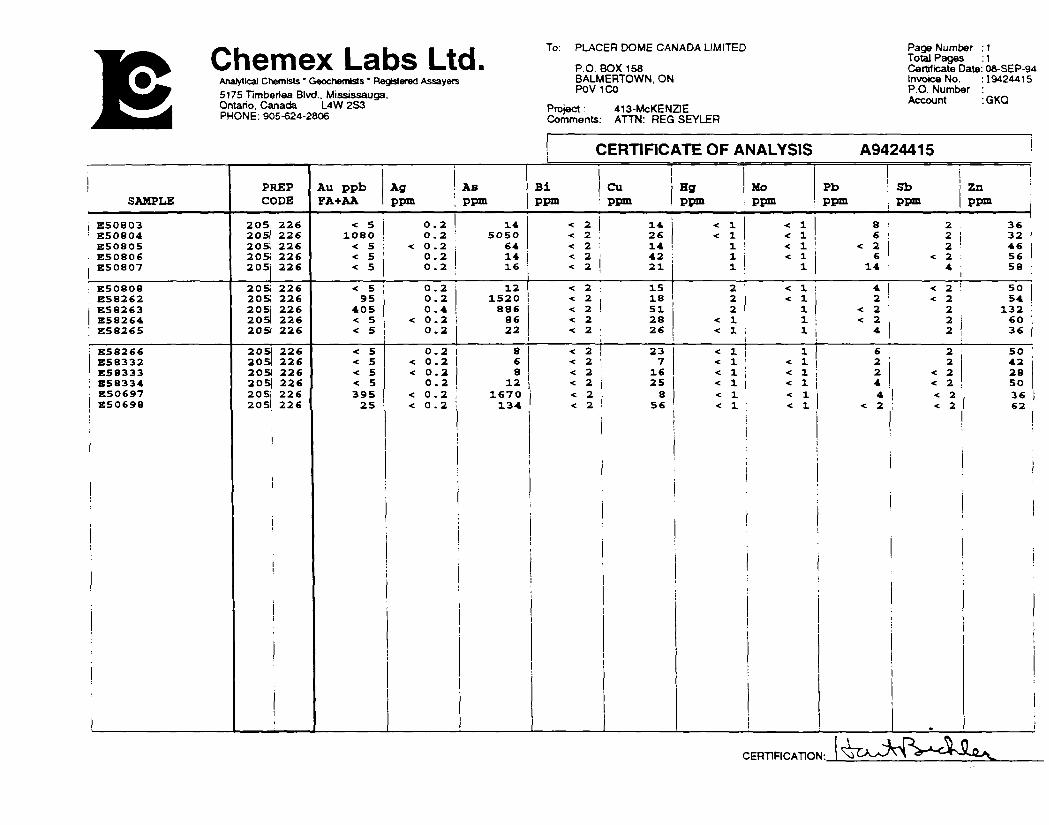
ROCK GEOCHEMISTRY
Sixteen rock samples were sent to Chemex Labs Ltd. in Vancouver for geochemical analysis.
Seven samples were taken from the trenched areas; the mean value of Au analysis from these areas
was 285.7 ppb with two of the seven samples returning values ^ ppb Au. All other samples taken
away from the trenched areas returned values ^ ppb Au.
TABLE 2
Anomalous Au Values
Sample No. Length Rock Code Au ppb
E50804 E58263E50897E50697
O.lm 4.0m*0 1m0 1m
qv 5d75b74b
5dqv
1080 405105395
*Sample E58263 was a composite chip sample from the strike length of Trench B (Dwg 2). Sample E50897 was taken from the south end of Trench B
RECOMMENDATIONS
Based on the 1994 work, anomalous Au assay values were returned from a quartz vein and
silicified intermediate to felsic volcanics on the east side of the property. Further mechanical stripping
could be done to determine the strike extent and width of this silicified zone; the depth extent of the
quartz vein could be tested by diamond drilling. However, no further work is recommended at this
time
May 1996 Stuart W. Deveau

-11-
REFERENCES:
ANDREWS, A.J., HUGON, H., DUROCHER, M., CORFU, F. AND LAVIGNE, M. J., 1986:
The Anatomy of a Gold-Bearing Greenstone Belt: Red Lake, Northwestern Ontario, Canada, in MacDonald, A.J., ed., Proceedings of Gold '86, an International Symposium on the Geology of Gold, Toronto, 1986, p 3-22.
BALD, R.C. AND CAMERON, D.M., FEBRUARY, 1983:Geochemical Report and Chemical Analyses on the McKenzie Island Claim Group and McCarney Claims, McKenzie Island, Dome Township, Red Lake Mining Division, Ontario
BONIWELL, J.B., SEPTEMBER, 1981:V.L F. Survey Results, McKenzie Island Claims Group, Dome, Fairlie Twps , Red Lake, Ontario
CAMERON, D.M., JULY, 1981:Report on Magnetometer Survey, McKenzie Island Property, Dome and Fairlie Townships, Red Lake Mining Division, Ontario
CAMERON, D.M., JULY, 1983:Power Stripping, Gold Fields Canadian Mining Limited, Claims KRL 490438 and KRL 540636, McKenzie Island Group, Dome Township, Red Lake Mining Division, Ontario
CHUTE, M.E., JANUARY, 1982:Geological Report on the McKenzie Island Claim Group, McKenzie Island, Dome and Fairlie Townships, Ontario
DONALDSON, W.S., APRIL, 1987:Report on the Diamond Drilling Program on the Red Lake Area, District of Kenora, Patricia Portion, Ontario
HORWOOD, H.C., 1940:Forty-ninth Annual Report of the Ontario Department of Mines, Vol. XLIX, Part II, Geology and Mineral Deposits of the Red Lake Area, p 156-167
RUSK, S.N., NOVEMBER, 1986:Geological Report for the McKenzie Island/Slate Bay Property, Dome and Fairlie Townships, Red Lake Area, District of Kenora, Patricia Portion, Ontario

-12-
SEARA, J.L., FEBRUARY, 1983:Geophysical Report on the Detail I.P Surveys, Report # 8002 4.4, McKenzie Island, Dome Township, Red Lake, Ontario
SMITH, P.A., DECEMBER, 1986:Dighemra Survey of the McKenzie Island Property, Red Lake, Ontario

-13-
CERTIFICATE OF QUALIFICATIONS
I HEREBY STATE THAT:
l I currently reside at 212 Hammell Road, Red Lake, Ontario.
2. I am employed as a Contract Geologist/Assistant Landsperson with Placer Dome Canada Limited, in Cochenour, Ontario.
3 I possess a Bachelor of Science (Honours) Degree in Geology from Acadia University, where I graduated in 1988, and a Master of Science Degree in Earth Sciences (Geology) from Memorial University of Newfoundland, where I graduated in 1992, and have practiced in my profession since 1993.
4. I am an Associate of the Geological Association of Canada
5. This report is based upon published and unpublished sources of information, and field work conducted during 1994.
6. To the best of my knowledge, all of the information contained with this report is factual and true.
7 At no time, have I received or expect to receive any interest, directly or indirectly in the property
Dated at Cochenour, Ontario, Canada this day of-
/( L, i t /— 1996
l i tell i..' Stuart W Deveau, B Se , M.Sc

APPENDIX I
Sample Descriptions

APPENDIX I Sample Descriptions
SAMPLEDE50697E50698E50803E50804E50805E50806E50807E50808E582621E58263-E58264"1
E58265E58266E58332E58333E58334E50S9TVE50898"E50899ivE50900iv
E58269KE58270KE58271 VE58272VE58273VE58274VE58275
1 Chip sample along Trench A a Chip sample along Trench B m Chip sample along Trench C K Trench B v Trench A
WIDTH (m)
0.1
3.0 4.0 4.0
0. 0. 0. 0. 0. 0. 0. 0. 0. 0.
TYPEgrabgrabgrabchipgrabgrabgrabgrabchipchipchipgrabgrabgrabgrabgrabchipchipchipchipchipchipchipchipchipchipgrab
ROCK CODEqv5a5bqv12c5d5b5d
5b712c5b5b5d5b5b5b5b5d5b5b4b4b4b5a5a5d5d5a
AU (ppb)39595<5
1080^<5<5<595
405^<5<5<5^<510511469122
90/802721
76

APPENDIX II
Analyses
Chemex Labs LtdAnalytical Chemists' Gsochemtsls * Registered Assayers5175 Timberlea Blvd.. Mississauga. Ontano, Canada L4W 2S3 PHONE: 905-624-2806
To: PLACER DOME CANADA LIMITED
P.O. BOX 158 BALMERTOWN, ON POV 1CO
Project: Comments:
413-McKENZlE ATTN: REGSEYLER
Page Number : 1 Total Pages : 1 Certificate Date: 08-SEP-94 Invoice No. : 19424415 P.O. Number : Account :GKQ
CERTIFICATE OF ANALYSIS A9424415
SAMPLE
E50803E50804E50805E50806E50807
E50808E58262E58263E58264E58265
B58266E58332E58333
, E58334E50697E50698
!
PREPCODE
205,20512051205i205
205;205!205J205)2051
205120920S205)205i205i
226226226226226
226226226226226
226226226226226226
Au ppbFA-l- AA
Ag Asppm i ppm
•e 5 0.21080
Bi Cuppm ' ppm
14 K 20.2 ! 5050
< 5 -c 0.2 : 64< 5 0 .2< 5
Hg Mo Pb Sb 'ppm : ppm ppm ppm
14 K 1< 2 26 < i
< 1< 1
Zn :ppm
8 2 366 2 32 i
< 2 14 1: -el! < 214 < 2 42 : 1
0.2 16 -c 2 21 1
< 5 0.2 1295
4050.20.4
1520886
< S < 0 .2 86< 5 0.2
< 5< 5< S< 539525
22
< 2 - 1 5•c 2 18•e 2 51< 2 2 8* 2 26
< l1
2 466 < 2 56
14 4 58i2 -ci: 422
< 11
< 2 ! 502 < 2 54
< 2 2 132 :< 1 ' l i -e 2 2< i 1 4
1 1 l
0.2 8 < 2 23< 0 .2< 0 .2
0.2
68
< 2 7•n 2 16
•e 1 i 1
26036
6 2 50•el 1 -e 1 2K 1 i -e 1 j 2
12 < 2 25 -ci •ci 4< 0.2 i 1670< 0.2 134
1
:
•c 2 : 8 < 1 -c 1< 2 56 -c 1 ; -el
i
l
1
2< 2
4228
< 2 ! 504 < 2 36
< 2 < 2 62
|
: !
i
.
CERTIFICATION:

PLACER DOME RESEARCH CENTRE Geochemical Analysis
Sample Type: CORE NTS: 52N4
ProjecWenture: 413E Submitted by R SEYLERArea: RED LAKE GEN Lab Proiect No.: D4319Remarks:Au - 10.0 g sample digested with Aqua Rega and determined by Graphite Furnace A.A ;D L l PPB)ICP - 0.5 g sample digested with 4 ml Aqua Rage at 100 Deg C for 2 hours.N.3. The major oxide e4emetts. Ba. Be. Cr. La and Ware rarety cfssorved completely with this acid dissolution method
Date Received: Date Completed:
CCT 1Z 1994 OCT 13. 1994
Page i of : Ann: RED LAKE EXPL OFF
E KIMURA
SAMPLE No.
F50897ES0898E50899
E50900! E5826B
E58270E5827.1
DUP E58271
l E58272E58273E58274E58275
STD SPK-P1
Au ppb
105114
69122
9080
2721
7640
Ag ppm
-0.1-0. 1-0. 1
0.10.20.10.10.1
0.10.1-0.1-0.10.3
Mo ppm
443
55344
4435
63
Cu ppm
282446
6173211313
6717127
27
Pb ppm
12tt8
17IS251715
1511111754
Zn ppm
457251
1072071074745
79544882
140
As ppm
61511920
3533928
524537
622618
52436
Sbppmrfrfrf
9rfrfrfrf
rfrfrfrfrf
Cd ppm
0.20.20.3
0.31.10.50.30.3
0.30.2
•rf). 10.10.3
Ni ppm
321G22
45
182323
3615111631
Co ppm
2087
1013141011
147576
Mn PPm
347398232
561823717446435
350387423690586
Bi opm^^^
-3.^^•C2.^
^•G.•c2•e2^
Cr
ppm595131
3625254444
45352725
101
V ppm
14106
92041
87
1210raa
33
Ba ppm
373838
3326443332
43363236
168
W ppmrfrfrf
rfrfrfrfrf
14rfrfrfrf
Bepom
0.20.20.2
0.30.30.50.30.2
0.40.20.20.30.4
La ppm
171511
4343312222
30191617
7
2^Ppm
252831
6537243333
4149896080
Ti "fe
^.01•CO.OI.tf.OI
0.010.02
^.01•eO.01^.01
"JO.OI•eO.01•eO.01O.01
0.09
A)^
0.861.150.72
1.732.12i690.760.69
1.201.201.181.281.01
Ga *
1.571.171.07
1.991.590.661.921.96
1.302. 162.883.870.95
Fe *1.732.561.69
4.465.225.161.821.70
2.952.172.202.782.27
Mg*
OJMa430.24
0.801.181.610,57054
0.49i 0.51j 0.49i 0.87i 0.83
K S,
0.200.180.22
0.100.080.150.180.18
0.180.180.160.190.35
Ma *
0.050.040.04
0.030.030.030.040.04
0.040.040.040.020.06
P ^
0.050.05O.C4
0. ;6'3.170.140060.05
0.070.050.050.05OG8

APPENDIX III
List of Personnel
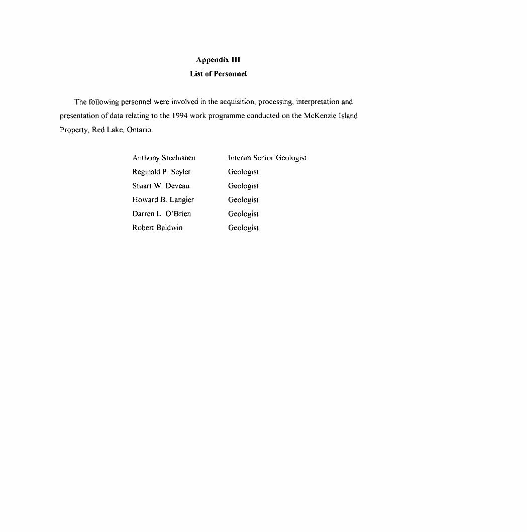
Appendix III
List of Personnel
The following personnel were involved in the acquisition, processing, interpretation and
presentation of data relating to the 1994 work programme conducted on the McKenzie Island
Property, Red Lake. Ontario
.Anthony Stechishen Interim Senior Geologist
Reginald P Seyler Geologist
Stuart W. Deveau Geologist
Howard B Langier Geologist
Darren L. O'Brien Geologist
Robert Baldwin Geologist

Ministry offlorthem Developmentand Mines
Ontario
Report of Work Conducted After Recording Claim
Mining Act
Transaction Number
Personal information collected on this form is obtained under the authority o* trw Mining Ad. This intomwtionwil be used lwthis cotectic* should be directed to the Provincial Manager. Mining Lands. Ministry of Northern Development and Mines. Fourth Floor. 159 Cedar Street.Sudbury. Ontario. P3E 6A5. telephone (705) 670-7264.
Instructions: - Please type or print and submit in duplicate.- Refer to the Mining Act and Regulator *
Recorder.- A separate copy of this form must be- Technical reports and maps must acot- A sketch, showing the claims the word
2-165 5.---—-— t . . — J. -- ......u *k.
52N04SW007S 2 16558 DOME 900Recorded HeJder(s) dent No.
Ad*M*
Mining DMaion f /t. O Pent ^3 o.
L A
Tomship/Aie
t-
W From: /\ ri
O lClO/J /, ' r M
To:
Work Performed (Check One Work Group Only)
\,'WorkGroup
Geotechnical Survey
Physical Work.Inducing Drilling
Rehabilitation
Other Authorized Work
Assays
Assignment from Reserve
Type
siC'tOii-w f i-irflvL-'toL#fmiS7~^ ri r~ "~ r" l l f P" l"\R E v. L 1 V C U
MAY i 7 1996
MINING LANDS BRANCH
Total Assessment Work Claimed on the Attached Statement of Costs
Note: The Minister may reject for assessment work credit all or part of the assessment work submitted if the recorded holder cannot verify expenditures claimed in the statement of costs within 30 days of a request for verification.
Persons and Survey Company Who Performed the Work (Give Name and Address of Author of Report)Name
.^//^iCr A- OtLvZJU.
Address
ttxHft. 3Q tJriiWtCtt KOfjr'J. K f t) Lt}U.f . C'f\J i'OJ .?tl~tiLJf f *
f
(attach a schedule H necessary)
Certification of Beneficial Interest * See Note No. 1 on reverse side
l certify that at the lime the work was performed, the claims covered In this work report were recorded in the current holder's name or held under a beneficial Interest by the current recorded holder.
•"•y i d™ M
Certification of Work Reportl certify that l have a personal knowledge of the facts set forth in this Work report, having performed the work or witnessed same during and/or after Its completion and annexed report Is true.
Name and Address of Person Certifying
For Office Use OnlyTotal Value Cr. Recorded Date Recorded ,
^/IJ&AS/ lC l f frDeemed Approval Date
Mining Recorder 'fi
Date Approved 1
Date Notice lor Amendments Sent
Recsi&FJ&nP** MINING DIV. ————
MAY 1 0 1996AM PU7.8i9iB.ll.gilt2i8.4.5,6
\W41 (0391)

05/13/96 10:19 PAI 18077352274 PLACER DOVE E1P -.-*-* VINE REG REDLAKE ®002
?*-fiff!
ir
1
l
I
(
1 s
l
No
Ne
i0
!
1 f^
* >
i
1
A
^SF ——
^
reotoyo Mendel
Do DCr Der
• 1: En 10
t 2: Hi
tee ted l*
— .i
so
ise|ftill^
M.RBiBBmH*Worn lo b*ClolnMdal m Futim DM*
i ere chiming in this reflorl may b u you wish to pnorizft Ihe detediMJBi ere u to cut tack ctorpng t dna ara lo DO cut neck equally o dita an} to De cut bock u priori*
il thai you have not speadod you
a out bock. In order to mMn
•WltfM
vtiM td on
rchok
eWm natod hit. *w, Chlms contained ta Ihe aiuched eppemU.
nBOUM How
nUngl (hhiar..
•i of priority. opOun ono wl
i advene effecn of tuch deleikmc i ol the following:MCfcoantt. 0rt of wont*
1 be IfnpMfnerMed.
mptea of btneflcW Wcnai etc unrecorded trenefero. option agreeoienia. memorandum of egreemenu, etc., wiih nraped he mining claim*.
oik Ma been parlormvd on pelenled or Iteaad hmd. pkMM comptele the lotowmg;
A* l*oon*od hoktar 1*4 t beneflcW UMrau ta he ptfentee' id al me tjme the -ort -so parrormea
Skjnolon) 0*1
Ontario
Ministry olNorthern Developmentand Mines
Ministere du Devetoppement du Nord ei des mines
Statement of Costs for Assessment Credit
Etat des couts aux fins du credit devaluation
Mining Act/Loi sur les mines
Transaction No IN' de transaction
k it uc
Personal information collected on this form is obtained under the authority of the Mining Act. This information will be used to maintain a record and ongoing status of the mining daim(s). Questions about this collection should be directed to the Provincial Manager. Minings Lands. Ministry of Northern Development and Mines. 4th Floor. 159 Cedar Street. Sudbury. Ontario P3E 6A5. telephone (705) 670-7264.
Les renseignements personnels contenus dans la presente formute sent recueillis en vertu de la Lot sur le* mines et serviront a tenir a jour un registre des concessions minieres. Adresser toute quesiton sur la coHece de ces renseignements au chef provincial des terrains miniers. ministers du Developpemenl du Nord et des Mines. 159. rue Cedar. 4e etage. Sudbury (Ontario) P3E 6A5. telephone (705) 670-7264.
1. Direct Costs/Couts directs
Type
Wages Salalres
Contractor's and Consultant's Fees Drortsd* I'entrepreneur et de rexpert- consell
Supplies Used Foumiturm utfflsees
Equipment Rental Location de materiel
Description
Labour (IH / ifo, du -) Main-d'oeuvre
Field Supervision Supervision sur le terrain
Typ.^
//V.^VSt S
Type
Type
Amount Montant
P/c't'
Q33
Total Direct Costs Total des coOts directs
Totals Total global
3ICC
t{23
5^3
2. Indirect Costs/CoQts indlrects* * Note: When claiming Rehabilitation work Indirect costs are not
allowable as assessment work.Pour to remboursemenl des travaux de rehabilitation, tes couts indirects ne sont pas admissibtos en tant que travaux d'evaluation.
Type
Transportation Transport
Food ftnd Lodging Nourrttureet hoDcrpdncnt
DemobHlzatfonMobfflsctlofi rtiManotiiii.aaatiVMa ocinooiiisaiion
Description
Type
Amount Montant
Sub Total of Indirect Coste Total partlel des couts Indirect*
Amount Allowable (not greater than 20* of Direct Costs) Montant admlsslbte (n'excedant DM 20 H des couts Oracle)Total Value of Assessment Credit Vatour totato du cnMK (TeM ol Direct end AftowaM* d'evakiatfonIndkeet etMtol (ToM dM cote dkeete
Totals Total global
^
^
asaaMbi
Note: The recorded holder will be required to verify expenditures claimed in this statement of costs within 30 days of a request for verification. If verification is not made, the Minister may reject for assessment work all or part of the assessment work submitted.
Note : Le trlutaire enregistre sera tenu de verifier les depenses domand6os dans le present etat des couts dans les 30 jours suivant une demand* A cet effet. Si la verification n'est pas effectuee. to ministre pent rejeter tout ou une partie des travaux d'evaluation presentes.
Filing Discounts Remises pour depot
1. Work filed within two years of completion is claimed at 10044) of the above Total Value of Assessment Credit.
1. Les travaux deposes dans tes deux arts suivant tour achevement sent rernbourses a 100 * de la vateur totato susmerrSonnee du ere* d'evaluation.
2. Work filed three, four or five years after completion is claimed at 50Vt of the above Total Value of Assessment Credit. See calculations below:
Total Value of Assessment Credit Total Assessment Claimed
x 0.50
Certification Verifying Statement of Costs
l hereby certify:that the amounts shown are as accurate as possible and these costs were incurred while conducting assessment work on the lands shown on the accompanying Report of Work form.
that as(Recorded Holder. Agent. Position in Company)
2. Les travaux deposes trois. quatre ou cinq ans apres teur achevement sont rembourses a 50 "ft de la valeur totato du credit d'evaluation susmentionne. Voir les calculs ci-dessous.
Vatour totate du credit d'evaluation
x 0.50
Evaluation totato demand**
Attestation de I'etat GEIVEDLAKE MINING DIV.
J'atteste par la presente :que les montants indiques sjty^jb f lug ^Mft P085'0*6 et que cesdepenses ont etd engggees pour effectuer les trawauK d'evaluation
l am authorized Et qu'a titre de(tilulaire enregistre. representant. poste occupe dans la
suis autorise lie)
to make this certification a faire cette attestation.
Signature7 / I
_ ' - - . " * L i' - —— t ' ~ - '. '•i^'"'. ———
Date
fi':.-: U . -Nota : Dans celte formuie. kxsqu'il designe des personnes. le masculm est uMis* au sens neufe.

OntarioMinistry of MinistereduNorthern Development Developpement du Nordand Mines et des Mines
August 02, 1996
Geoscience Assessment Office 933 Ramsey Lake Road g tn Floor Sudbury, Ontario P3E 6B5
Telephone: (705) 670-5853 Fax: (705) 670-5863
Our File: 2.16558 Transaction #: W9620. 00021
Mining RecorderMinistry of Northern Development fc MinesOntario Government Building227 Howey Street, Box 324Red Lake, OntarioPOV 2MO
Dear Mr. Rivett:
SUBJECT: APPROVAL OF ASSESSMENT WORK CREDIT ON MINING LAND, CLAIM (S) 1184170 IN DOME TOWNSHIP
Assessment work credit has been approved as outlined on the Declaration of Assessment Work Form accompanying this submission. The credit has been approved under Section 12, Geology, of the Assessment Work Regulation.
The approval date is August 02, 1996. Please indicate this approval on the claim record.
If you have any questions regarding this correspondence, please contact Steven Beneteau at (705) 670-5855.
Yours sincerely, ORIGINAL SIGNED BY:
Ron C. GashinskiSenior Manager, Mining Lands SectionMines and Minerals Division
SBB/jf
cc: Resident Geologist Red Lake, Ontario
Assessment Files Library Sudbury, Ontario

LEGEND*;, Mblf..WITHDRAWN .FROM DISPOSITIONM.R.O. -MINING RIGHTS ONLY S.R.Q. - r,U**ACE RIGHTS ONLYM.+ t. - MIN'N^IAND SURFACE RIGHTS
D****t*ttton Onto No. DM* Disposition
HK.HWAt AMI) HOI ' H
i ' l in il ROADSOWNSHIPMCDONOUGH.M (h .'f Y H i l l
T l lANSHII'S H A'.t i IMI ', : !till!, MININd ( l A:M', I'AH' i i l
UN')' .H , t N M i MM S iaec,M CUM/M ao/oe/aa MRO
l UTji INI iAti .
(.1 AIMS l l i
AM[J RK ,lt l (K
t INt S
NNIAl S! ML AM
M i x i l Nij l )R M (K ittlMd K li j H l S
'VISION OH l,UMK)Sl M fi AN
HtSF K'v A T IONS
UHI(,INAl SHOHtLINF
MARSH OH MUSKtG
MINhS
THAVt-HSl MONUMl NT
Slate
1208996-— — JL "i —. .CBL T mn. ~* ——— T- ST f— -*-
I T96B26
•*
* — - ~iTL r —i. r
* K"U "T KftT ~ K Rt
11443641__ i
KRL j KHL KHL796920 l 798*46 l 79696O
! N '•* ~ t" ~ 4l 7A69I9 l 796945 l 796959
DISPOSITION OF CROWN LANDS' KHL l KRL "T KBt "P*
-- i——-7^—r/TYPE OF DOCUMENT/V . L i i i————i—t
KRL KRL ' l __ _ JL. _ L— _ . - —— —U —t
KRL i KRL [47905 KRL KRL 'l -VAMA.H ' -*r.js l A j* .d 7QCOKA l
•12089971 PA T f NT SUM f- ACF 8, MININC, HU.K IS
SuHi- ACt MK.MTS i )N;
MINING HKiH IS ON l t
l E ASf . SURf A( t 8i MININf , M K, H: S
SURI ACt H K, H l S ON l V
MININC, Rll.HTS ONl Y
LICf NCf Ol OCCUPATION
ORUfcH IN COONC It
R{ SI RVAT ION
CANCF LLED
SAND 81 GRAVEL
4-- --r-T76ilO j 796918 796
l ir B tl — -f- —
KRL X ; ^a'j KHL [J" HI 5O9679 / KRI \ 5096110
^ HI/- ^x 4790^16 l 47 i
— -H KRI•5385 l 5388
14 l I 92IB
- 4--~ -h -- 4-
NOT t MININl, H If "i M l 'j IN I'AHIflSPAtl-NUl'PHIOH l
1913 V CSTtd IN iHL.iNAl P ATlNltt R V T M( CljBI l i LANDS A( l HSU ' ' i H i ( H AK ISO SI t. l Si rtSf i l
KRL KRL j KRL | KRL KRL 776209 l 7 7620S j 7761*7 ! 77SUS l 796949 l 796948
lSURFACE RIGHTS TRANSFERRED T O CANADA IN A REA
SHOWN THUS-i, • ••f;-'-'-"- / AT RED LAKE AERODROME,FILE 6 1894 REF 141*83 O C
r~ ~~ ~ rKRL i KRL l KRL . ML KRLJ—-^"~ l//KRL
776208 l 776204* n ' 776196 669611
J l 1^696,5 L----
-h — -
10 O 10 /(l .10 •ID li) bO 'O
iOO O 1000 ^000 JIJOO 4000 MJlllMoel869616
SCALw 1:20 OOO
FOREST ACTIVITY INFORMATIONTHIS TOWNSHIP/AREA FALLS WITHIN THF
RED LAKE CROWN
i 1389*8 i 859001 l 869658 |
X...J.THE M.N.R. UNIT FORESTER FOR THIS AHEA CAN Bl CONTACTED AT
P.O. BOX 5003RED LAKE, ONTARIO POV 2MO(807) 727-2253
KRL . KRL 839002 ' 869689
KRL T -"i **
—— QMK23Z
o h i II
™ — —— J. —— —
KRLKKL l 423290.J
42323201___ ,_ ^ ..
9044-69 9044^0
THF INFORMATION T IA' APPFAR;; ON THIS MAIHAS BLFN COMPII Eh FROM VARIOUS SOURt F' AND ACCURACY IS NO t GUARANTEED I"HOSf WISHING TO STAKE WIN ING CLAIMS SHOULD COh SUIT WITH THE MINiN(, RECORDER, MINISTRY Of NORTHERN DEVELOP MENT AND MIMES, FOR AD DITIONAL INFORMAT.ON ON THE STATUS OF .HE LANDS SHOWN HEREON
O
97550
197551
TOWNSHIPptM-m i c? DOME
M N R ADMINISTRATIVE DISTMCT
RED LAKEMINING DIVISION
RED LAKELAND TITLES/ REGISTRY DIVISION
KENORA / PATRICIA
Ministry ofNaturalResources
Ministry ofNorthern Developmentand Minesj , f 1 "'-1 ." ; ''", :''V " 's " k
NHIPSEPTEMBER 1986
G-3748

-c
1184170#4
((5/16)/ 5b '^X. -j; \ . .x;
x
77
7x
' Birch,/' ';
I/1
1117-'
BL 0+OON 1 — * ——
/^,
LP 400 N 9
1
11
f/in/- Small Poplar
l 8. Balsam
l
1l
f Small Balsam ^•--^^X^ LP 380m W
x
i *^
'^
If
Balsam, Poplar, 8c Spruce
^, -~~~ A
m ^
Alder*
^^ — ^-.^ —
1 — b^.
K5/6)
Spruce
C J-^^•-^
"^-^^^^-~-
i v \ ^i—? X \ E50806;',
\x
Mature Sprite,ialsam, Poplar^. •^~
Poplar, 8. Pine
Balsam,Spruce
Small Alder,
* ^
.
KRL* —
^5b~
8, Poplar
^ '.5ta'E58333((5/8)
* - _ ^^
Birch, Balsam,8. Spruce
^• -^^
^^^ ^.
— ~ " — — r- ^d,py E58265 X5c,
(O/22)
-^."~-^"O^ ^..^ ^ •^ im "^
Spruce, ... 5^
Ol^p*i5d^e.
E58266 ^5/8)
Spruce
Spruce, S, T-Brush
Poplar,8. Balsams^^
1184170
- — -. ^^ ^- ^^^
Small Sp 8. Aide
Spruce, Pop 8c Birch
. 5b . . 4b
"S"py 5b i
-* ^~~-^^ LJ^ ~- 01 "^"--41rt ^^ ~,x^ E58334 ^^-^^
^ ^\\ f 1184170\\ Spruce i # 1
s \ 8. 1, V Birch 7
/' 5b./1 -- 7Alder x^ 5to py /
' A *xt50803l/ -N\ 7 ^5/14)
-•^ ~~S.^^ 7
/'s' ' 5d^-~y/x ' ... 1 ^ ^.
s'S ' E50805 x /-x ^5,64) i
Mdo^, ^ r . Jj,1 ' ' J'\5daT ,: 6^^^tz d aspy'
3.0 |vi H '' E50804 7•'-tf \\ u * 1080/5050 f -p. 0
\\ -7 UWQ. d.r-^ ^ C===L ——— 1 J-' i. y i l—
\\* 1M \ 7
A tl 'Open ;1 ( \Spruce/
\\\ '•/r. 73iufr:-rj ; 7
Vi i 'ruce y
/f P 400n S
7 \
1 'f
l//^
E50808 "/' !^5/12) l 1 ' l'/
1
7 ji M
H84170 LEGEND "^.y f^ i1184170 ry\\
4 INTERMEDIATE TD FELSIC METAVDLCANICS *2 \fj^Q (tholeiitic and calc-alkaline dacltes and andesites) 1 ^^- 4b Intermediate Tuff f ^* OCM 7 ^ v v-t n
5 FELSIC METAVDLCANICS f — 4 K. r\ *-J ""'(rhyolite flows and5b Felsic Tuff
pyroclastics) ' Q * \J ^^^U ^ ^^
•••H 50 Felsic Crystal Tuff w"IHHBl 5e Felsic Agglomerate
55 . Swamp
iS^B x"-~-'' Ski Traill^SSEHHB — - -~ Claln Llne
SB j* m aa* post5=1 * Line Post
^^^^5^——•1 -' - " Dutcrop
5i^^^5l qtz quartz
,, e SCALE (METRES)-i — r- Ridge
x. Semple Location PlSH^——JHHl——^—^BMBHBf—^^qE50808 Semple Number IQQ 50 0 100 200 300
(1080/5050) Geochemistry Result (Au/As) //l /l
J Drill Holes tWa^l /lil
eg- -V Bsddlng (Inclined, vertical) /y'i/^^. ^ h/Ju U™^
•*~/^ Foliation (vertical) . ————————— *—— , ————————————————————————————— —————PC^IMB) 413E - MCKENZIE ISLAND PROPERTY
py py-ite IDRAVN SKS?' T^^A, , -,^,^ ,DATE 9501.23 u^MWi.NU i
asp or-senopyrlte SCALE Ii2500 r r uptfr u y ueuluyy ""H
1 NO. Ei\REDLAKE\MCKENZIE\DWG\413SMACK.DWG
4
5
12
0x
E50804
SCALE (METRES)
E50804quartz vein with pyrite, chalcopyrite and arsenopyrite
rubble fron pit
debrisfron
trenches
E58263 (93/1530) - chip sanple over 3m along trench A E58263 (405/886) - chip sanple over 4n altng trench B E58864 (((3/86) - chip sanple over 4n along trench C
BL 0+OON
LEGENDINTERMEDIATE TD FELSIC METAVDLCANICS 4a Intermediate Flow
FELSIC METAVDLCANICS 5d Felsic Crystal Tuff
MINOR FELSIC INTRUSIVES12c Quartz-Feldspar Porphyry
Trench
Sample Location
Ridge
Shear Zone
Bedding
Foliation (inclined vertical)
Quartz Vein
Clam LinekHXRDOME
52N04SW0075 2 16558 DOME 220
DRAWN SWD
DATE 95i01i23
SCALE Ii250
413E - MCKENZIE ISLAND PROPERTY
DRAWING 2Detailed Geology Map
of Trenched and Stripped AreaMCI. D\REDLAKE\HCKENZIE\DWG\DRAWING2.DWG