0 washington v~;:rih~~g; geology -...
TRANSCRIPT
V
0
LIi
INSIDE THIS ISSUE
I The metallic, nonmetallic, and industrial mineral industry of Washington in 1996, p. 3
I From clay to bricks, p. 12 1 Washington's coal industry-1996, p. 15 I Puget Sound bluffs and the where, why, and when of
landslides following rain-on-snow events, p. 17
WASHINGTON v~;:R
2iH~~g; GEOLOGY
WASHINGTON STATE DEPARTMENTOF
Natural Resources Jennifer M. Belcher - Commissioner of Public Lands Kaleen Cottingham - Supervisor
WASHINGTON GEOLOGY
Vol. 25, No. 1 March 1997
Washington. Geology (ISSN 1058-2134) is pub li shed fo ur ti mes each year by the Washington State Department of Natural Resources. Division of Geology and Earth Resources. This publi catio n is free upon re quest. The Divis ion al so pub lishes bullet ins, infor mation c irculars . reports of investigation s, geo logic maps, and open-file reports. A lis t of these publications will be sent upon request.
DIVISION OF GEOLOGY AND EARTH RESOURCES
Raymond Las man is, State Geologist J . Eric Schu ste r, Ass istant S tate Geologist Wi ll iam S. Lingley. Jr. , i\.uista11t Srute Geologist
Geologlsts IOlympla) Joe D. Dragov ich We ndy J. Gers tel Ro bert L. (Josh ) Logan David K. Norman Stephen P. Palmer Patrick T. Pringle Katheri ne M. Reed Henry W. (Hank) Schassc Timothy J. Walsh Weldo n W. Rau (volunteer)
Geologist (Spokane) Robert E. De rkey
Geologists IReglonsl Garth An de rson ( Northwest) Charles W. (Chuck) Gu lick
( Northeast) Rex J . Hapala (Southwest) Lorraine Powell (Snz11heas1) Stephanie Z urenko (Central)
Senior Librarian Co nn ie J . Manson
Library Information Speclallst Lee Walkling
MAIN OFFICE Department of Natu ra l Resources Division of Geology
and Earth Reso urces PO Box 47007 O lympia, WA 98504-7007
Phone: (360) 902- 1450 Fax: (360) 902-1785
(See map on inside back cover for ma in office loca tion.)
/llfernet Connections: Library:
connie [email protected] lee .walkling@wad nr.gov
St1bscrip tio11s/address changes: j udy.hcndc rson @wadnr.gov
Editor Katherine M. Reed
Computer Information Consultant Carl F. T. Harris
Cartographers Keilh G. Ikerd Travis Young (temporary )
Production Editor/ Designer Jaretta M. (Jari) Ro loff
Data Communications Technician J. Renee Christe nsen
Administrative Assistant Janis G. Allen
Regulatory Programs Assistant Mary Ann Shawver
Clerlcal Staff Judy Hen derson Anne Heini tz Thuy Le
FIELD OFFICE Department of Natural Resources Division of Geology
and Earth Resources 904 W. Rivers ide, Room 209 Spokane, WA 9920 1- 10 11
Plume: (509) 456-3255 Fax: (509) 456-6 11 5
Publications available from the Olympia address only.
Copying is encouraged, bu t please acknowledge us as the sou rce.
-r .. Printed on recycled paper. ,_.,. Printed in rhe U.S.A.
URL: hup ://www.wa.gov/dnr/htdocs/ger/ger. html
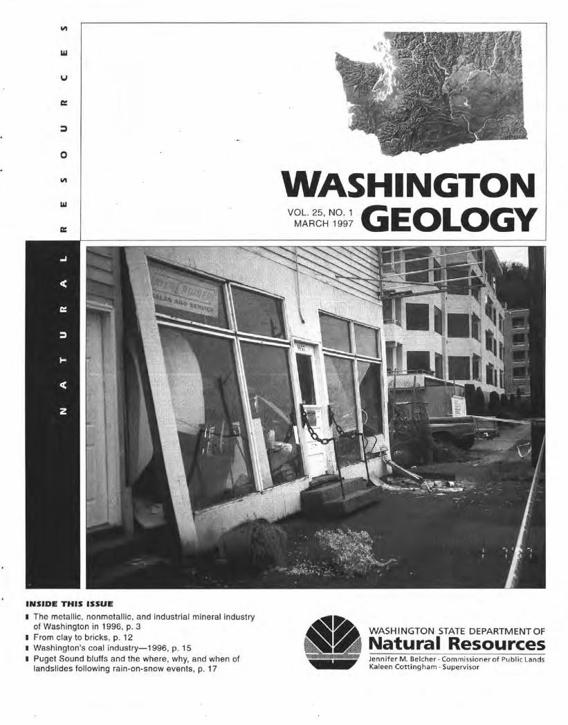
Cover Photo: The front wall of this boating supply store on Harbor Ave SE in Seattle was pushed out by one lobe of a debris flow that initiated on the bluff behind the store and broke through the rear wall. (Also see Figure 3, p. 18.) The other lobe flowed around the north side of the building and came to rest next to the truck (right side of photo) .
Z Washington Geology, vo l. 25, no. I. March 1997
Major l:vents Bring in 1 997
Raymond Lasmanis, State Geologist Washington State Department of Natural Resources Division of Geology and Earth Resources PO Box 47007, Olympia, WA 98504-7007
W inter weather sys tems d umped s now on Puget Sound communities. The snow, in combination with the sub
seque nt rain , caiused numerous landslides. T hese landslides resulted in fatalities and extensive property d amage. Even larger landslides seem possib le from information about the potent ial fo r devastating earthqu akes and the threat of massive mud flows fro m Moun t Rai nier that has been featu red in recen t newspapers. These kind s of rea l and potential events re mind us all that awareness of a threat from nature is not suffic ient by itse lf. U nde rs ta nding the geologic condi tions, se lecti ng mitigation meaisures , and implementing emergency preparatio n plans can reduce future losses.
In thi s issue of Washington Geology is a n artic le by the staff of the Department of Natu ral Resources and the Department o f Ecology abo ut the late December 1996 rain-on-snow events. The artic le documents the vari ous combinations of topography, geo logy, and hydrology that, combined wi th poor land-manageme nt practices, have created s ituatio ns lead ing to property loss a111d fataliti es.
In the regul atory arena, the fi nal E nvironmental Im pact State ment (FEIS) was issued fo r the Crown Jewel mine in Okanogan County. When permitted, thi s mine will counter the economic losses in northeast Washing to n caused by the closure of the Hecla operat ions at Republ ic, Ferry County, and of the Can non go ld mine and mi ll at We natchee, Chelan County . The Notice of Availabil ity was published in the Federal Regis ter on February 7, 1997. In the Record of Deci sion by the Forest Service and the Bureau of Land Management , Alternati ve B has been selected. Th is alternati ve is fo r an open- pi t mine to operate around the c lock to produce 3,000 tons of gold ore per 24-hr period . T he o re will be treated in a mill using on-si te tank cyanidation. Ore reserves have been calculated at 8.7 millio n tons with an average grade of 0 .186 oz of gold per to n, using a cu toff grade of 0.034 oz gold per Lon. A recent upswing in the price of gold has increased the reserve to 9 .1 mil lion to ns of ore. The appeal period fo r the Record of Decision for the Forest Service is 45 d ays from the date of pub! ication (Feb. 3, 1997) and the Bureau of Land Management 30 days from the elate of the no tice in the Federal Register (Feb. 7, 1997). •
Recently R1eleased
Assessing ea1rthquake hazards and reducing risk in the Pacific Northwest, volume I of U .S. Geological Survey Professio nal Paper 1560 . The volume ed itors are A. M. Rogers, T. J. Walsh, W . J. Kockelman, and G. R. Priest. Inc luded are a rt ic les about earthquake sources, pa leoseismicity, evo lution of the continenta l marg in , and earthquake foca l mechanis ms in western Washing to n. Plate I is a map showing known or suspec ted faults with Q uaternary di s plact~ment in northern Cali fo rn ia, Oregon , and Washing to n at a sca le of I :2,000,000.
The Metallic, Nonmetallic, and Industrial Mineral Industry of Washington in 1996 Robert E. Derkey Washington Division of Geology and Earth Resources 904 W. Riverside, Room 209, Spokane, WA 99201-1011
INTRODUCTION
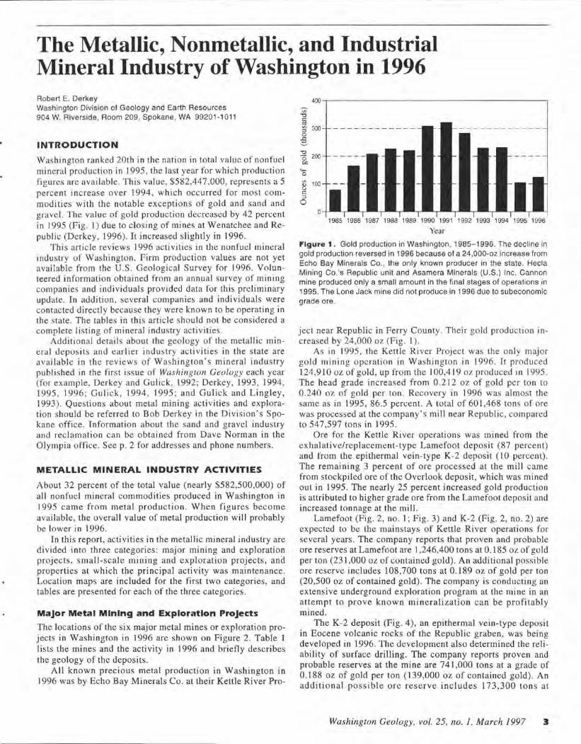
Washington ranked 20th in the nation in total va lue of nonfuel mineral production in 1995, the last year for which production figures are available. This value, 5582,447,000, represents a 5 percent increase over 1994, which occurred for most commodities with the notable exceptions of gold and sand and gravel. The value of gold production decreased by 42 percent in 1995 (Fig. I) due to closing of mines at Wenatchee and Republic (Derkey, 1996). It increased slightly in 1996.
This article reviews 1996 activities in the nonfuel mineral industry of Washington. Firm production values are not yet available from the U.S. Geological Survey for 1996. Volunteered information obtained from an annual survey of mining companies and individuals provided data for this preliminary update. In addition, several companies and individuals were contacted directly because they were known to be operating in the state. The tables in this article should not be considered a complete listing of mineral industry activities .
Additional details about the geology of the metallic mineral de posits and earlier industry activities in the state are available in the reviews of Washington's mineral industry published in the firs t issue of Washin gton Geology each year (for example, Derkey and Gulick, 1992; Derkey, 1993, 1994, 1995, 1996 ; Gulick, 1994, 1995; and Gulick and Lingley, 1993). Questions about metal mining activities and exploration should be referred to Bob Derkey in the Division ' s Spokane office. Information about the sand and gravel industry and reclamation can be obtained from Dave Norman in the Olympia· office. Seep. 2 for addresses and phone numbers.
METALLIC MINERAL INDUSTRY ACTIVITIES
About 32 percent of the total value (nearly $582,500,000) of a ll nonfuel mineral commodities produced in Washington in 1995 came from metal production. When figures become avai lable, the overall value of metal production will probably be lower in 1996.
In this report, activities in the metallic mineral industry are divided into three categor ies: major mining and exploration projects, small-scale mining and exploration projects, and properties at which the principal activity was maintenance. Location maps are included for the first two categories, and tables are presented for each of the three categories.
Major Metal Mining and Exploratlon Projects
The locations of the six major metal mines or exploration projects in Washington in 1996 are shown on Figure 2. Table I lists the mines and the activity in 1996 and briefly describes the geology of the deposits.
All known precious metal production in Washington in 1996 was by Echo Bay Minerals Co. at their Kettle River Pro-
"O 0 200 Oil
"""' 0
~ 100 u
"' :;)
0
1985 1986 1987 1988 1989 1990 1991 1992 1993 1994 1995 1996
Year
Figure 1 . Gold production in Washington , 1985-1996. The decline in gold production reversed in 1996 because of a 24,000-oz increase from Echo Bay Minerals Co., the only known producer in the state. Hecla Mining Co.'s Republic unit and Asamera Minerals (U.S.) Inc. Cannon mine produced only a small amount in the final stages of operations in 1995. The Lone Jack mine did not produce in 1996 due to subeconomic grade ore.
ject near Republic in Ferry County. Their gold production increased by 24,000 oz (Fig. I ).
As in 1995 , the Kettl e River Project was the only major gold mining operation in Washington in 1996. It produced 124,910 oz of gold, up from the 100,419 oz produced in 1995. The head grade increased from 0 .212 oz of gold per ton to 0.240 oz of gold per ton. Recovery in 1996 was almost the same as in 1995, 86.5 pen;ent. A total of 601 ,468 tons of ore was processed at the company's mill near Republic , compared to 547,597 tons in 1995.
Ore for the Kettle River operations was mined from the exhalative/replacement-type Lamefoot deposit (87 percent) and from the epithermal vein-type K-2 deposit ( lO percent). The remaining 3 percent of ore processed at the mill came from stockpi led ore of the Overlook deposit, which was mined out in 1995. The nearly 25 percent increased gold production is attributed to higher grade ore from the Lamefoot deposit and increased tonnage at the mill.
Lamefoot (Fig . 2, no. I; Fig. 3) and K-2 (Fig. 2, no. 2) are expected to be the mainstays of Kettle River operations for several years. The company reports that proven and probable ore reserves at Lamefoot are 1,246,400 tons at 0.185 OL of gold per ton (231,000 oz of contained gold) . An additional possible ore reserve includes 108,700 tons at 0.189 oz of gold per ton (20,500 oz of contained gold) . The company is conducting an extensive underground exploration program at the mine in an attempt to prove known mineralization can be profitably mined.
The K-2 deposit (Fig. 4), an epithermal vein-type deposit in Eocene volcanic rocks of the Republic graben, was being developed in 1996. The development also determined the reliability of surface drilling. The company reports proven and probable reserves at the mine are 741,000 tons a t a grade of 0.188 oz of gold per ton (139,000 oz of contained gold). An additional possible ore reserve includes 173,300 tons at
Washif!-gton Geology, vol. 25, no. 1, March 1997 3
JEFFERSON
r-----~--------, <) • " I
120°
. l . . . ..... ·-·-·-· -~ THURSTON\.~ r -- _____ ;_ /-...........
LEWIS
I r-1----·-·----~- -
ISKAMANIP i • ! L !
12J0 122° 12 1° 120°
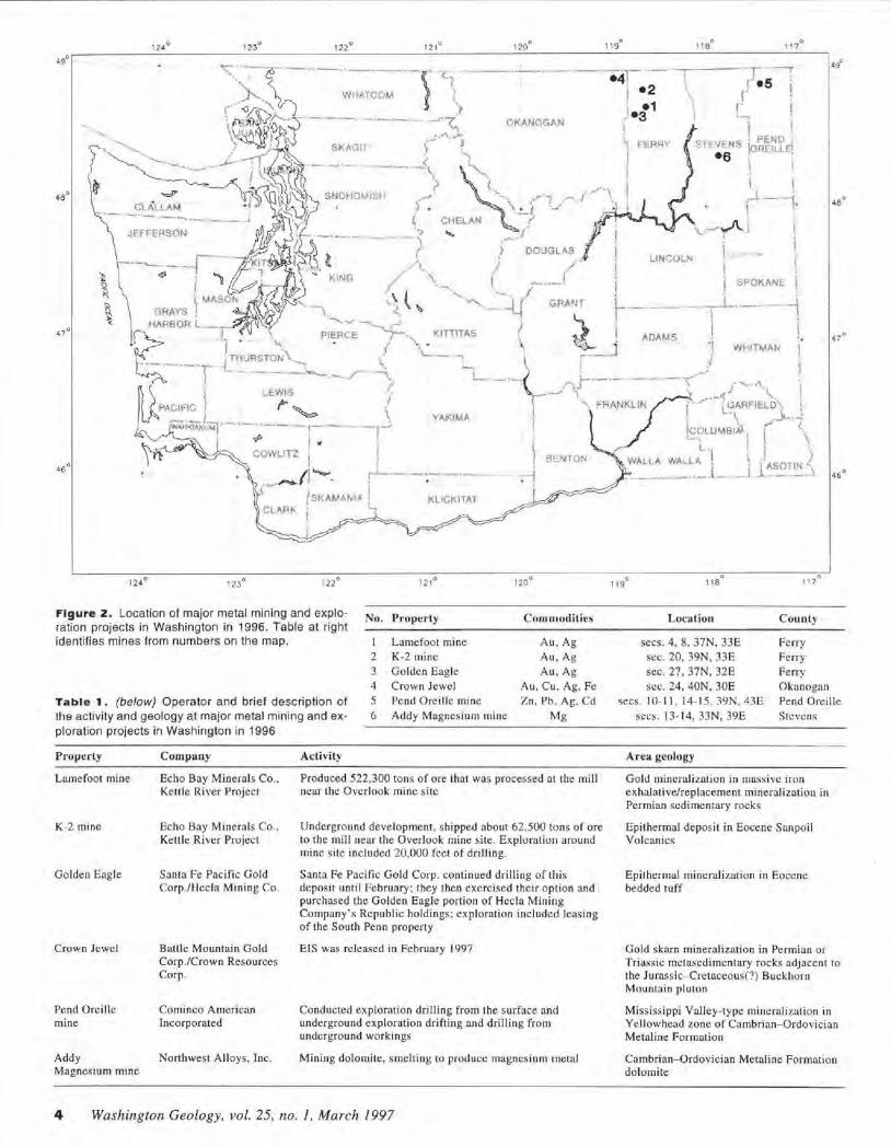
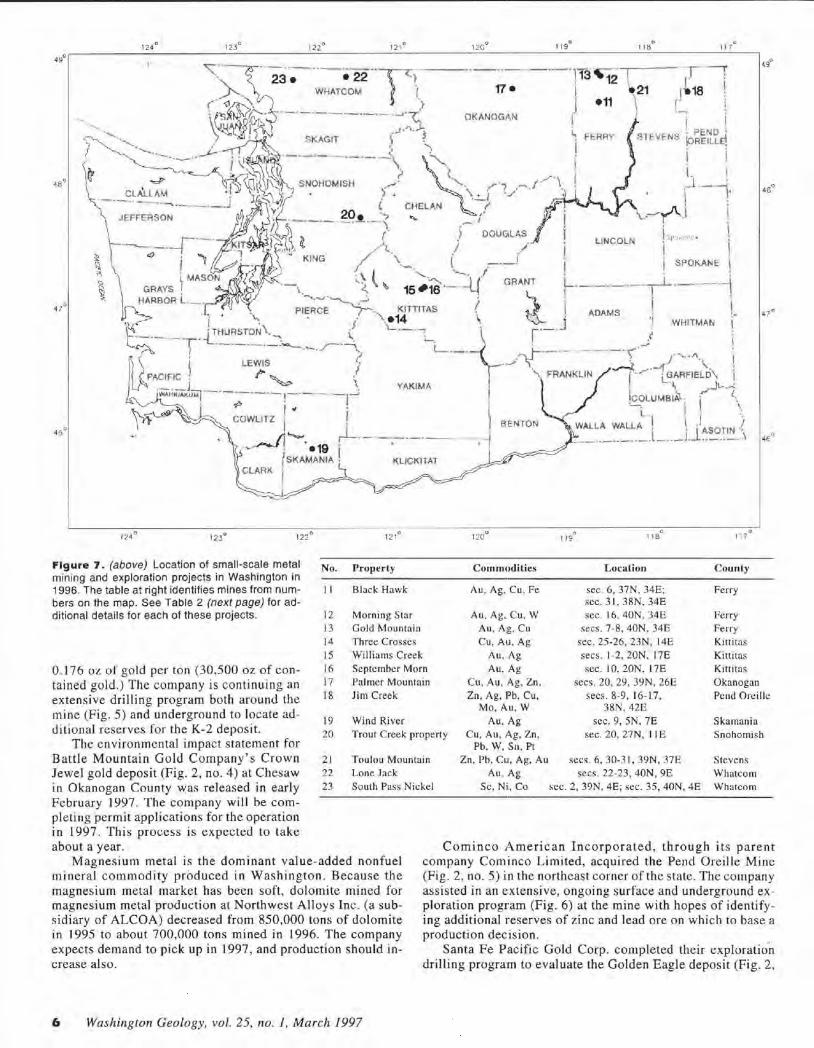
Figure 2. Location of major metal mining and exploration projects in Wash ington in 1996. Table at right identifies mines from numbers on the map.
No. Property
Lamefoot mine
Commodities
Au , Ag 2 K-2 mine Au,Ag
J Golde n Eagle Au , Ag 4 Crow n Jewel Au, C u. Ag, Fe
Table 1 . (below) Operator and brief description of the activity and geology at major metal mining and exploration projects in Washington in 1996
5 G
Pend Orei lle mine Z n, l' b., Ag. Cd Addy M agnes ium mine Mg
Property
Lamefoot mine
K-2 mine
Golden Eagle
Crown Jewel
Company
Echo Bay Minerals Co. , Kettle River Project
Echo Bay Minerals Co., Kellie River Project
Santa Fe Pacific Gold Corp./Hecla Mining Co.
Baille Mountain Gold Corp./Crown Resources Corp.
Pend Oreille Cominco American mine Incorporated
Addy Northwest A lloys, Inc. Magnesium mine
Activity
Produced 522,300 tons of ore that was processed at. the mill near the Overlook mine site
Underground deve lopment, shipped about 62.500 tons of ore to the mill near the Overlook mine s ite. Exploration around mine site included 20,000 feet of drilling.
Santa Fe Pacific Gold Corp. continued drilling o f this deposit until February; they then exercised their option and purchased the Golden Eagle porti on of Hecla Mining Company's Republic holdings; explorati on inc luded leasing of the South Penn property
EIS was released in February 1997
Conducted exploration drilling from the surface and underground exploration drifting and drilling from underground workings
Mining do lomite, smelting to produce magnesium rnetal
4 Wash ington Geology, vol. 25, no. 1, March 1997
0 119
0 I 18 1 17°
0 I 19
0 I 18
0 1 ' 7
Location
secs. 4, 8, 37N, 33E
sec. 20, 39N, 33E
sec. 27, 37N, 32E sec. 24, 40N, JOE
secs. 10- 11 , 14- 15, J9N.43E
secs. 13-14, 33N, 39E
Area geology
County
Ferry
Fe rry
Ferry Okanogan
Pend Oreille Stevens
Gold mineralization in massive iron exhalative/replacement mineralization in Permian sedime ntary rocks
Epithe rmal deposit in Eocene Sanpoil Volcanics
Epithcrmal mi neralization in Eoce ne bedded tuff
Gold skarn minerali zation in Permian or Triassic mctascd imcntary rocks adjacent to the Jurassic- Cre taceous(?) Buckhorn Mountai n pluton
Mississippi Valley-type mineraliza!ion in Yellowhead zone of Cambrian- O rdovician Metaline Formation
Cambrian-Ordovician Metaline Formation dolomite
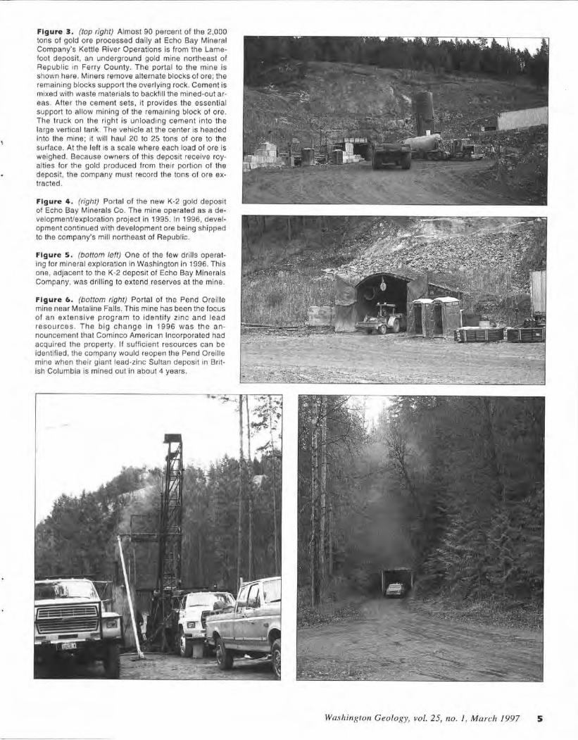
Figure 3 . (top right) Almost 90 percent of the 2,000 tons of gold ore processed daily at Echo Bay Mineral Company's Kettle River Operations is from the Lamefoot deposit, an underground gold mine northeast of Republic in Ferry County. The portal to the mine is shown here. Miners remove alternate blocks of ore; the remaining blocks support the overlying rock. Cement is mixed with waste materials to backfill the mined-out areas. After the cement sets, it provides the essential support to allow mining of the remaining block of ore. The truck on the right is unloading cement into the large vertical tank. The vehicle at the center is headed into the mine; it will haul 20 to 25 tons of ore to the surface. Al the left is a scale where each load of ore is weighed. Because owners of this deposit receive royalties for the gold produced from their portion of the deposit, the company must record the tons of ore extracted.
Figure 4 . (right) Portal of the new K-2 gold deposit of Echo Bay Minerals Co. The mine operated as a development/exploration project in 1995. In 1996, development continued with development ore being shipped to the company's mill northeast of Republic.
Figure s. {bottom left) One of the few drills operating for mineral exploration in Washington in 1996. This one, adjacent to the K-2 deposit of Echo Bay Minerals Company, was dril ling to extend reserves at the mine.
Figure 6 . (bottom righ t) Portal of the Pend Oreil le mine near Metaline Falls. This mine has been the focus of an extensive p rogram to identify zinc and lead resources . The big change in 1996 was the announcement that Cominco American Incorporated had acquired the property. If sufficient resources can be identified , the company would reopen the Pend Oreille mine when their giant lead-zinc Sultan deposit in British Columbia is mined out in about 4 years.
Washington Geology, vol. 25, no. I, Ma rch 1997 5
123°
Figure 7. (above) Location of small-scale metal mining and exploration projects in Washington in 1996. The table at right identifies mines from numbers on the map. See Table 2 (next page) for additional details for each of these projects.
No. Property
I l Black Hawk
12 Morning Star 13 Gold Mountain
Three Crosses Williams Cree k
120°
Commodities
Au, Ag. Cu, Fe
Au, Ag, Cu, W
Au, Ag, Cu Cu, Au, Ag
Au, Ag
0 1 19
118°
11B 0
117 0
Location County
sec. 6 , 37N, 34E; Ferry sec. 31, 38N, 34E sec. 16. 40N. 34E Ferry
secs. 7-8, 40N, 34E Ferry sec. 25-26, 23N, l 4E Kittitas secs. 1-2, 20N, 17E Kittitas
0.176 oz o f gold per ton (30,500 oz of contained gold.) The company is continuing an extensive drilling program both around the mine (Fig. 5) and underground to locate additional reserves for the K-2 deposit.
14 15 16 17 18
September Morn Palmer Mountain Jim Creek
Au,Ag Cu, Au, Ag, Zn. Zn, Ag, Pb, Cu,
Mo . Au, W Au, Ag
scc. 10,20N, 17E Kittitas secs. 20, 29, 39N, 26E Okanogan
secs. 8-9, 16-17, Pend Oreille 38N. 42E
19 Wind River sec. 9, SN, 7E Skamania
The environmental impact statement for Battle Mountain Gold Company 's Crown Jewe l gold deposit (Fig. 2, no. 4) at Chesaw in Okanogan County ~as released in early February 1997. The company will be com-
20 Trout Creek property Cu, Au, Ag, Zn, Pb. W, Sn , Pt
Zn, Pb, Cu, Ag, Au Au, Ag
sec. 20, 27N, I IE Snohomish
2 1 22
Toulou Mountain secs. 6 , 30-3 1, 39N, 37E secs. 22-23, 40N, 9E
Stevens Whatcom Whatcom
Lone Jack 23 South Pass Nickel Sc, Ni, Co sec. 2 , 39N, 4E; sec. 35, 40N, 4E
pleting permit applications for the operation in 1997 . This process is expected to la ke about a year.
Magnesium metal is the dominant value-added nonfuel mine ral commodity produced in Washington. Because the magnesium metal market has been soft, do lomite mined for magnesium metal production al Northwest Alloys Inc. (a subsidiary of ALCOA) decreased from 850,000 tons of dolo mite in 1995 to about 700,000 tons mined in 1996. The company expects demand to pick up in 1997, and production should increase also.
6 Washington Geology, vol. 25, no. ], March 1997
Cominco American Incorporated , through its parent company Cominco Limited, acquired the Pend Ore ille Mine (Fig. 2, no. 5) in the northeast corner of the state. The company assisted in an extensive, ongoing surface and underground exploration program (Fig. 6) at the mine with hopes of identifying additional reserves of zinc and lead ore on which to base a production dee ision.
Santa Fe Pacific Gold Corp. completed their exploration drilling program to evaluate the Golden Eagle deposit (Fig. 2,
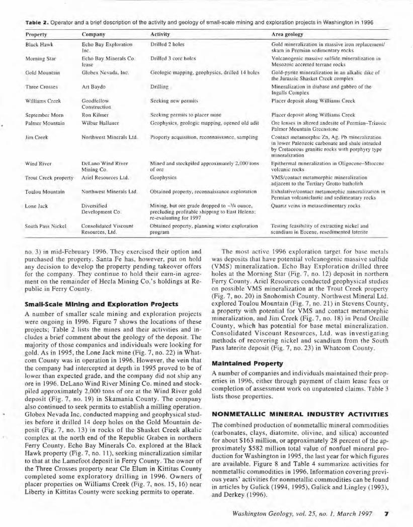
Table 2. Operator and a brief description of the activity and geology of small-scale mining and exploration projects in Washington in 1996
Properly
Black Hawk
Morning Star
Company
Echo Bay Exploration Inc.
Echo Bay Minerals Co. lease
Activity
Drilled 2 ho les
Drilled 3 core ho les
Area geology
Gold mineralization in mass ive iron replacement/ skarn in Permian sedimentary rocks
Volcanogenic massive sulfide mineralization in Mesozoic accreted terrane rocks
Gold Mountain Globex Nevada, Inc. Geologic mapping. geophysics, drilled 14 holes Gold-pyrite mineralization in an alkalic dike of the Jurassic Shaske! Creek complex
Three Crosses
Williams Creek
Art Baydo
Goodfellow Construction
Drilling
Seeking new permits
Mineralization in diabase and gabbro of the In galls Complex
Placer deposit along Williams Creek
September Morn
Palmer Mountain
Ron Kilmer
Wilbur Hallauer
Seeking permits to placer mine Placer deposit along Williams Creek
Geophysics, geologic mapping, opened old adit Ore lenses in altered andesite of Permian-Triassic Palmer Mountain Greenstonc
Jim Creek Northwest Minerals Ltd. Property acquisition, reconnaissance. sampling Contact metamorphic Zn, Ag, Pb mineralization in lower Paleozoic carbonate and shale intruded by Cretaceous granitic rocks with porphyry type mineralization
Wind Ri ver Delano Wind River Mining Co.
Mined and stockpiled approximate ly 2.000 Ions of ore
Epithermal mineralization in Oligocene-Miocene volcanic rocks
Trout Creek property Arie l Resources Ltd . Geophysics VMS/contact metamorphic mineralization adjacent to the Tertiary Grotto batholith
Toulou Mountain Northwest Minerals Ltd . Obtained property. reconnaissance exploration Exhalative/contact metamorphic mineral ization in
Permian volcaniclas ti c and sedimentary rocks
Lone Jack Diversified Development Co.
Mining, but ore grade dropped to -3/4 ounce, precluding profitable shipping to Easr Helena: re-evaJua1ing for 1997
Quartz veins in metasedimentary rocks
South Pass Nickel Consolidated Viscount Resources, Lid .
Obtained properly, planning winter exploration program
Testing feasibility of extracting nickel and scandium in Eocene, resedimented laterite
no. 3) in mid-February 1996. They exercised their option and purchased the properly . Santa Fe has, however, put on hold any decis ion to develop the property pending takeover offers for the company. They continue to hold their earn-in agreement on the remainder of Hecla Mining Co. 's holdings at Republic in Ferry County.
Small-Scale Mining and Exploration Projects
A number of smaller scale mining and exploration projects were ongoing in 1996. Figure 7 shows the locations of these projects; Table 2 lists the mines and their activi ties and includes a brief comment about the geology of the deposit. The majority of those companies and individuals were looking for gold . As in 1995, the Lone Jack mine (Fig. 7, no. 22) in Whatcom County was in operation in 1996. However, the vein that the company had intercepted al depth in 1995 proved to be of lower than expected grade, and the company did not sh ip any ore in 1996. Delano Wind River Mining Co. mined and stockpiled approximately 2,000 tons of ore at the Wind River gold deposit (Fig . 7, no. 19) in Skamania County. The company also continued to seek permits to establish a milling operation . Globex Nevada Inc. conducted mapping and geophysical studies before it drilled 14 deep holes on the Gold Mountain deposit (Fig. 7, no. 13) in rocks of the Shasket Creek alkalic complex at the north end of the Republic Graben in northern Ferry County. Echo Bay Minerals Co. explored at the Black Hawk property (Fig. 7, no. 11), seeking mineralization si milar to that at the Lamefoot deposit in Ferry County. The owner of the Three Crosses property near Cle Elum in Kittitas County completed some exploratory drilling in 1996. Owners of placer properties on Williams Creek (Fig. 7, nos. l 5, 16) near Liberty in Kittitas County were seeking permits to operate.
The most active 1996 exploration target for base metals was deposits that have potential volcanogenic massive sulfide (VMS) mineralization . Echo Bay Explorat io n drill ed three holes at the Morning Star (Fig. 7, no. 12) deposit in northern Ferry County . Ariel Resources conducted geophys ical studies on possible VMS mineralization at the Trout Creek property (Fig. 7, no. 20) in Snohomish County. Northwest Mineral Ltd. explored Toulou Mountain (Fig. 7, no. 21) in Stevens County, a property with potential for VMS and contact metamorphic mineralization, and Jim Creek (Fig. 7, no. 18) in Pend Oreille County, which has potential for base metal mineralization. Consolidated Viscount Resources , Ltd. was investigatin g methods of recovering nickel and scandium from the South Pass laterite deposit (Fig. 7, no. 23) in Whatcom County .
Maintained Property
A number of companies and individuals maintained their properties in 1996, either through payment of claim lease fees or completion of assessment work on unpatented claims. Table 3 lists those properties.
NONMETALLIC MINERAL INDUSTRY ACTIVITIES
The combined production of nonmetallic mineral commodities (carbonates, clays, diatomite, olivine, and silica) accounted for about $163 million, or approximately 28 percent of the approximately $582 million total value of nonfuel mineral production for Washington in 1995, the last year for which figures are available. Figure 8 and Table 4 summarize activities for nonmetallic commodities in 1996. Information covering previous years' activities for nonmetallic commodities can be found in articles by Gulick ( 1994, 1995), Gui ick and Lingley (1993 ), and Derkey ( 1996).
Washington Geology, vol. 25, no. 1, March 1997 7
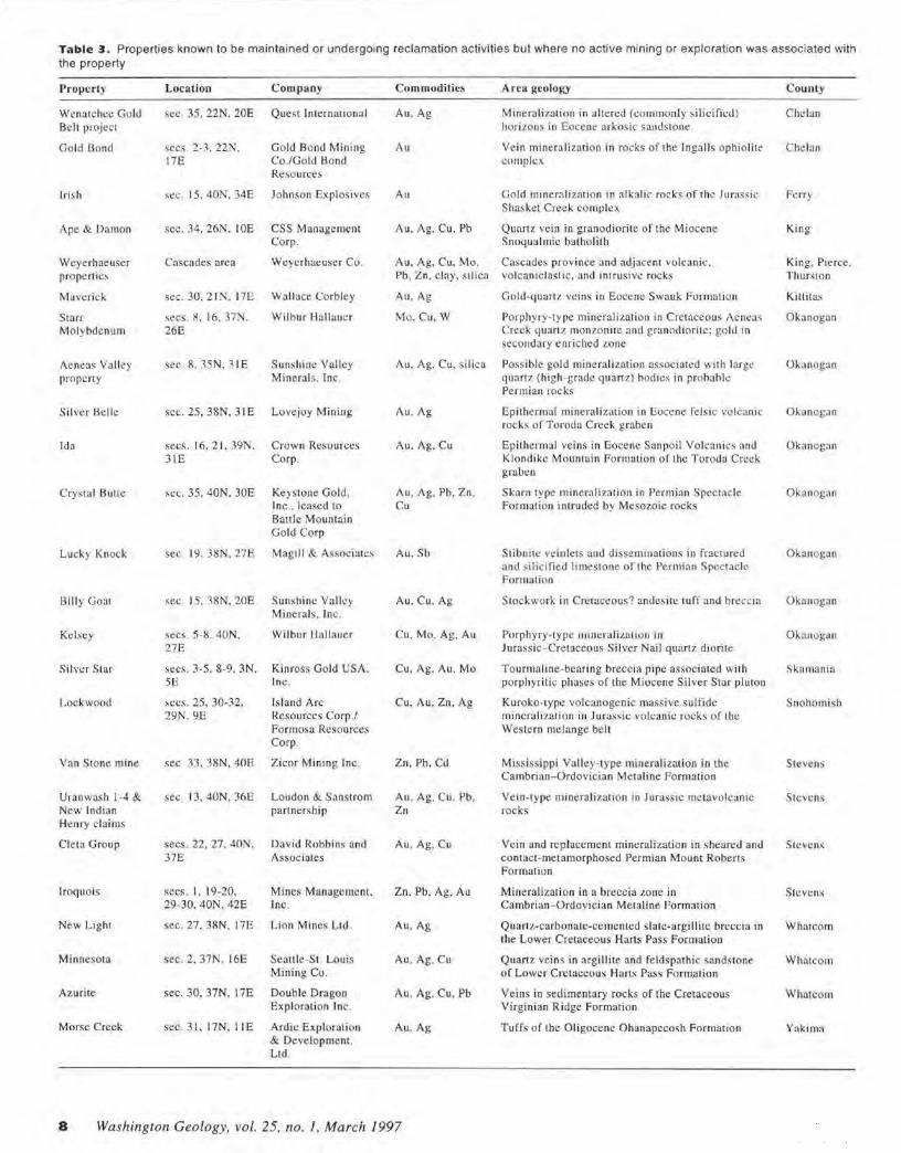
Table 3. Properties known to be maintained or undergoing reclamation activities but where no active mining or exploration was associated with the property
Property Location Company Commodities Arca geology County
Wenatchee Gold sec. 35. 22N, 20E Quest Inte rnationa l Au, Ag Mineralization in altered (commonly s ilicifil:d) Chelan Belt project horizons in Eocene a rkosic sandstone.
Gold Bond secs. 2-3, 22N. Gold Bond Mining Au Vein minera lization in rocks of the Ingalls ophiolite Chelan 17E Co./Gold 13ond complex
Resources
Irish St:C. 15. 40N, 34E Johnson Explosives Au Gold mineralizat ion in alkalic rock s of the Ju rassic Ferry Shaskel Creek complex
Ape & Damon sec. 34, 26N, !OE CSS Management Au, Ag, Cu. Pb Quartz vein in granodiorite of the Miocene King Corp. Snoqualmie balholilh
Weyerhaeuser Cascades area Weyerhaeuser Co. Au, Ag, Cu, Mo, Cascades province and adjacent volcanic. King, Pierce. prope rties Pb, Zn. clay. silica volcan iclast ic, and intrusive rocks Thurston
Maverick sec. 30. 21 !'/. 17E Wallace Corbley Au,Ag Gold-quartz ve ins in Eocene Swauk Formation Killitas
Starr secs. 8, 16, 37N, Wilbur Hallauer Mo. Cu, W Porphyry-type mineralizat ion in Cretaceous Aeneas Okanogan Mo lybdenum 26E Creek qua rt z mon7onite and granodioritc; gold in
secondary e nriched zone
Aeneas Valley sec. 8. 35N, 31 E Sunshine Valley Au, Ag. Cu, silica Possible gold mineralization associated with large Okanogan propcn y Minerals. Inc. quart7 (high -grade quartz) hodies in prohahlc
Permi an rocks
Silver Helle sec. 25, 38N, 31E Lovejoy Mining Au, Ag Epithermal mineralization in Eocene felsic volcan ic Okanogan rocks o f Toroda Creek graben
Ida secs. 16, 21 , 39N, Crown Resources Au, Ag. Cu Epithermal veins in Eocene Sanpoil Vol canics and O kanogan 31E Corp. Klondike Mountain Formation of lhc T oroda Creek
graben
Crysta l Autte sec. 35, 40N. 30E Keystone Gold, Au, Ag. Pb. Z n. Skarn type mineralization in Permian Spectacle Okanogan Inc., leased to Cu Formation intruded by Mesozoic rocks Battle Mo untain Gold Corp
Lucky Knock sec. 19. 38N. 278 Magill & Associates Au, Sb Stibnite ve inlets and disseminations in fractured Okanogan and silicified li mestone of the Permian Spec1aclc Formation
Bi lly Goat sec. 15, 38N, 20E Sunshine Valky Au, Cu. Ag Stock work in Cretaceous? andesite tuff and breccia Okanogan Minerals. Inc .
Kelsey secs. 5-8, 40N. Wilbur Hallauer Cu, Mo, Ag. Au Porphyry-typt: 111im:ralization in O kanogan 27E Jurassic- Cretaceous Si lver Nail quartz diorite
Silver Star secs. 3-5, 8-9, 3N, Kinross Gold USA, Cu, Ag. Au. Mo To urmaline·-bearing breccia pipe associated with Skama ni a SE Inc. porphyritic phases of the Miocene Silver Star pluton
Lockwood secs. 25, 30-32, Is land Arc Cu, Au, Zn. Ag Kuroko- typ,! volcanogenic massive sulfide Snohomish 29N. 9E J{esources Corp./ mineralizati on in Jurassic volcanic rocks of the
Formosa Resources Western melange belt Corp.
Van Stone mine sec. 33, 38N, 40E Zicor Mining Inc . Zn, Pb, Cd Mississippi Valley-type mineralization in the Stevens Cambrian- Ordovician Metaline Forma tion
Uranwash 1-4 & sec. 13, 40N. 36E Lo udon & Sanstrom Au , Ag. Cu , Pb, Vein-type minera lizatio n in Jurassic metavolcanic Stevens Ne w Indian partner. hip Zn rocks He nry claims
C leta G roup secs. 22, 27, 40N . David Robbins and Au. Ag, Cu Vei n and replacement mineralization in sheared and Stcvcns 37E Associates contact -metamorphosed Pe rmian Mount Roberts
Formation
Iroquois secs. I , 19-20, Mines Management, Zn. Pb, Ag, Au Mineralizali.on in a breccia zone in Stevens 29-30, 40N, 42E Inc. Cambrian- Ordovician Metaline Formation
New Light sec . 27, 38N, l7E Li on Mines Ltd. Au, Ag Quartz-carbonate -cemented slate-argillite breccia in Whatcom the Lower Cretaceous Harts Pass Formation
Minnesota sec. 2. 37N, l6E Seattle-St. Louis Au. Ag, Cu Quartz veins in argillite and feldspathic sandstone Whatcom Mining Co. of Lower Cretaceous Harts Pass Formation
Azurite sec. 30, 37N. I 7E Double Dragon Au. Ag. Cu, Pb Ve ins in sedimentary rocks of the Cretaceous Whatcom Exploration Inc. Virginian Ridge Formation
Morse Creek sec. 31, 17N, l lE Ardic Exploralion Au, Ag Tuffs of the Oligocene Ohanapccosh Formation Yakima & Development. Ltd.
8 Washington Geology, vol. 25, no. !, March 1997
123°
12J0
\20°
11h OK.ANOGAI\I
•112
120°
0 119
- ,-113 • I
I I L,
I FERR'
C 118
I •118 i • 117 . ..J - -\.
! _..y,1\ 1
118° C
117
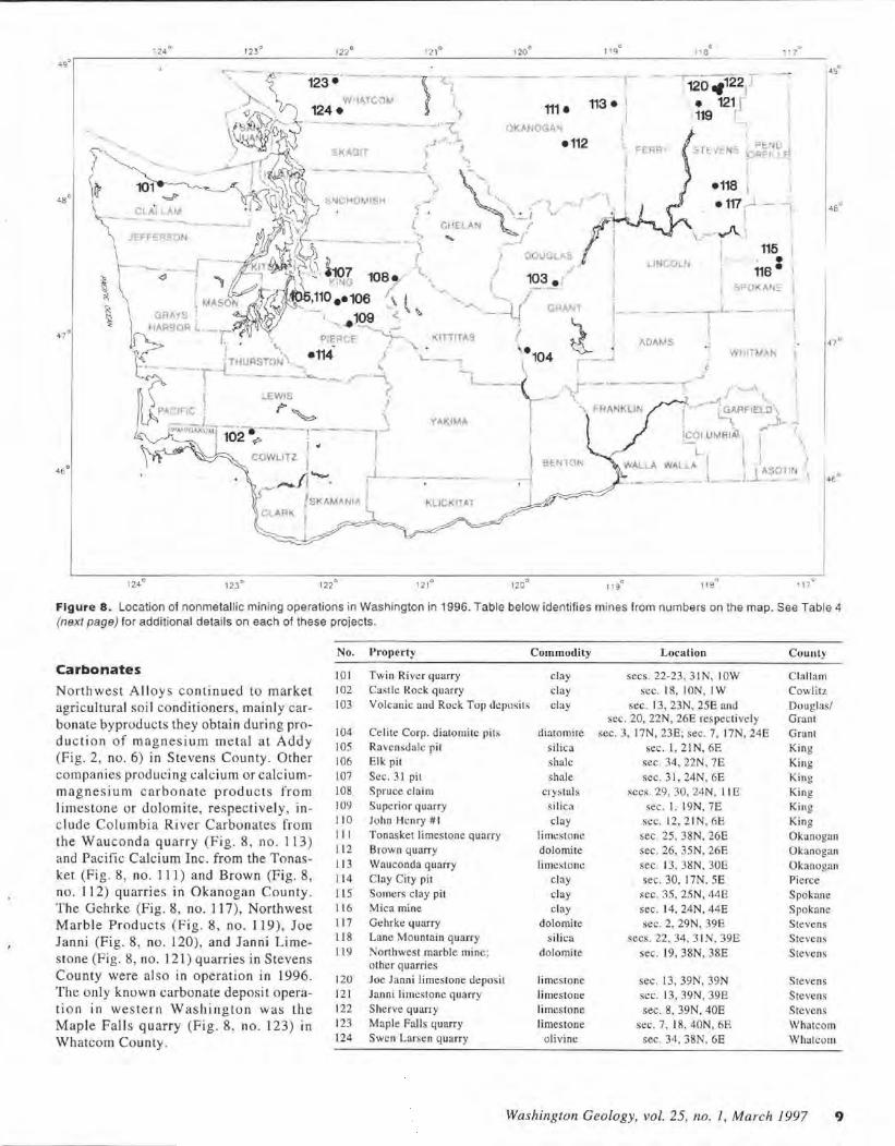
Figure 8. Location of nonmetallic mining operations in Washington in 1996. Tab le below identifies mines from numbers on the map. See Table 4 (next page) for additional details on each of these projects .
Carbonates
Northwest Alloys continued to market agri cultural soil conditioners, mainly carbonate byproducts they obtain during produc ti on of magnesium metal at Addy (Fig. 2, no. 6) in Stevens County. Other companies producing calcium or calciummagne sium carbonate produ cts from limes tone or dolomite, respectively, inc lude Columbia River Carbonates from the Waucond a quarry (Fig. 8, no . 113) and Pacific Calcium Inc. from the Tonasket (Fig. 8, no . 111) and Brown (Fig. 8, no . 112) quarries in Okanogan County. The Gehrke (Fig. 8, no. 117), Northwest M arble Products (Fig. 8, no. 119), Joe Janni (Fig. 8 , no. 120), and Janni Limes to ne (Fig. 8, no. 121) quarries in Stevens County were also in operation in 1996. The only known carbonate deposi t operation in western W as hington was the Maple Fall s quarry (Fig. 8, no. 123) 1n Whatcom County .
No. Property
IOI 102 103
104 105 106 107
108 109 11 0 111 112
113 11 4 115 11 6 117 11 8 119
120 121 122 123 124
Twin River 4uarry Castle Rock quarry Volcanic and Rock Top deposits
Celite Corp. diatomite pits Ravens<lalc pit Elk pit Sec. 3 1 pit Spruce c laim Superior quarry John Henry # I Tonas ket limestone quarry Brown q uarry Wa uconda quarry Clay City pit Somers clay pit Mica mine Gehrke q uarry Lane Mountain quarry
o rthwes t marble mine; olhcr quarries Joe Janni limes tone deposit Janni limestone quarry She rve quarry Mapl e Falls quarry Swen Larsen quarry
Commodily
clay clay clay
diatomire
silica shale shale
crys tals sil ica clay
limestone
dolomite limestom:
clay clay clay
dolomite si lica
dolomi te
limestone
limestone limestone limes tone
olivine
Location
secs. 22-23, 3 1N, IOW sec. 18, ION, IW
sec. 13, 23N, 25E and sec. 20, 22N, 26E respectively
sec. 3. 17N, 23E; sec. 7, 17N. 24E sec. l , 21N, 6E
sec. 34, 22N. 7E
sec. 31, 24N, 6E secs. 29, 30, 24N, I I E
sec . I , 19N, 7E St:C. 12, 2 1N, 6E
sec. 25, 38N. 26E sec. 26, 35N. 26E sec. 13, 3i!N, 30E sec. 30, 17N. SE
sec. 35, 25N, 44E sec. 14, 24N, 44E sec. 2, 29N, 39E
secs. 22, 34. 3 1N, 39E
sec. 19, 38N, 38E
sec. 13, 39N, 39N sec. 13, 39N, 39E sec. 8, 39N, 40E
sec. 7, 18, 40N, 6E sec. 34, 38N. 6E
County
C lall am Cowlitz
Douglas/ Grant Grant King King
King King Kin g K ing Okanogan Okanogan Okanogan Pierce Spokane Spokane Stevens Stevens Stevens
Stevens Stevens Stevens Whatcom Whatcom
Washington Geology, vol. 25, no. / , March 1997 9
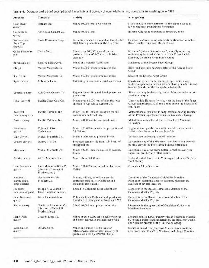
Table 4 . Operator and a brief description of the activity and geology of nonmetallic mining operations in Washington in 1996
Property
Twin River quarry
Castle Rock quarry
Volcanic and Rock Top deposits
Celite Diatomile pits
Ravcnsdale pit
Elk pit
Sec. 3 1 pit
Spruce c laim
Superior quarry
John Henry # I
Tonaske t limestone q ua rry
Bro wn quarry
·wauconda quarry
Clay City pit
So mers clay pit
Mica mine
Gehrke quarry
Lane Mountain quarry
Northwest marble mine; other quarries
Joe Janni limestone deposit
Janni li mestone quarry
S herve q uarry
Maple Falls quarry
Swen Larsen quarry
Company
Holnam Inc.
Ash Grove Cement Co.
Dasie Resources Corp .
Celitc Corp .
Reserve Silica Corp.
Mutual Materials Co.
Mutual Materials Co.
Robert Jackson
Ash Grove Cement Co.
Pacific Coas t Coal Co.
Pacific Ca lci um, Inc.
Pacific Calcium, Inc.
Columbia River Carbonates
Mutual Materials Co.
Quarry T ile Co.
Mutua l Materia ls Co.
Allied Mine rals , Inc .
Lane Mountain Silica Co. (division of Hemphill Brothers, Inc.)
Nonhwest Marble Products Co.
Joseph A. & Jeanne F. Janni limestone deposits
Peter Janni and Sons
Northport Limestone Co. (division of Hemphill Brothers, Inc. )
Cla uson Lime Co .
Olivine Corp.
Activity
Mined 60,000 tons. development
Mined 40,400 tons
Pcrmilling is nearly completed. target is for 40,000 tons produc tion in the first year
Mined over 100,000 tons of ore and produced about 65,000 tons of fini shed dia tomite
Mined and washed 70,000 tons
Mined 13,000 tons to produce bricks
Mined 65.000 tons to produce bricks
Extrac ting mineral and crystal specimens
Exp loration dr illing and development, no production
Mined over 60,000 tons of clay that was shi pped to Ash Grove Cement Co .
Mined 16,000 tons of limestone for soil conditioner and feed lime
Mined 4,000 tons for soil conditioner
Mined 10 5,000 tons with net production of 78,000 tons
Mined 6,500 tons to produce bricks
Produced ceramic tile from 1.545 tons of stockpiled ore
Mined 42,000 Lons, stockpiled lo produce br icks
Mined about 3,000 LOns
Mined 300,000 tons, milled at plant near Valley
Mining. milling, color/site specific aggregate materials for building and industrial applications
Leased to Columbia River Carbonates
Columbia River Carbonates shipped some limestone to thei r plant in Wood land. WA
Mined 40,000 tons, processed on sile
Mined about 60.000 tons. used for rip rap and some aggregate and landscape rock
Mined and milled 4 1,000 tons for refractory/incinerator uses; majority of production used by UNJMIN Corp.
1 0 Washington Geology, vol. 25, no. 1, March 1997
Area geology
M udstone(?) in three members of the upper Em:cnc to lower Miocene Twin Rivers Formation
Eocene- Oligocene nearshore sedimentary rocks
Calcium bentonite (clay) interbeds in Miocene Columbia River Basalt Group near Moses Coulee
Miocene "Quincy diatomite bed", a locally occurring sedimentary interbed at the base of the Pries t Rapids Member, Columbia River Basalt Group
Sandstone o f the Eocene Pugel Group
lllite- and kaolinite-bearing s hales of the Eocene Puget Group
Shale of the Eocene Puget Group
Quartz and pyrite crys tals in large. open voids along fo ulte.d megabreccia in the northern phase granodiori te and tonalir.c (25 Ma) of the Snoqualmie balholith
Silica cap in hydrothermally altered Miocene andesites on a caldera margin
Upper middle Eocene silty clay near the base of the Puget Group comprising a 30-rt-thick zone above the Franklin #9 coal scam
Metacarbonate rocks in the conglomerate-bearing member of the Pe rmian Spectacle Formation (Anarchist Group)
Metadolomite member of the Triassic Cave Mountain Format ion
High-calcium, pre-Tert iary white marble lenses in mica schist , calc-silieate rocks. and hornfcls
Tertiary kaolin-bearing, altered andesite
Lacustrine clay of the Miocene Lata h Formation overlain by si lty c lay o f the Ple is tocene Palouse Formation
Lacustrine clay of Miocene Latah Formation overlying sapro liti c, pre-Tertiary fe lsic gneiss.
l~olated pod o f Proterozoic Y Stensgar Dolomite(?) (Deer Trail Group)
Cambrian Addy Quartzite
Dolomite of the Cambrian-Ordovician Metaline Format ion ; add itional colored dolomite products arc quarried at several locations
Deposit is in the Reeves Limestone Member of the Cambrian Maitlen Phyllite
Deposit is in the Reeves Limestone Member of the Cambrian Maitlen Phy llite
Limestone in the upper un it of Cambrian- Ordovician Metaline Formation
Sheared, jointed Lower Pennsylvanian limestone overlain by sheared argillitc a nd undcrlain by argill itt:, graywacke, and volcanic brecc ia of the Chilliwack Group
Dunite is mined from the Twin Sisters Dunitc (outcrop area more than 36 mi2
) in Whatcom and Skagit Counties
Ollvlne
Olivine Corp. mined ol ivine in 1996 from its Swen Larsen quarry (Fig. 8, no. 124) in the Twin Sisters dunite body in Whatcom County. The company uses some of its production to construct wood a nd municipal waste incinerators for international customers a nd supplies crushed olivine to UNIMIN, a Belgian company that produces cast ing sands and other re fractory produc ts at Ha milto n.
Clays
Mutual Materials mined clay for making bricks in Spokane County at its Mica mine (Fig. 8, no. 116), in King County at its E lk (Fig. 8, no. I 06) and Section 3 I (Fig. 8, no. J 07) pits, a nd from its Clay City (Fig. 8, no. 11 4) pit in Pierce County. Quarry Tile Company produced ceramic tile from c lay mined from the Somers p it (F ig. 8, no . 115 ) in Spokane County. Much of the c lay produced in western W ashingto n (Fig. 8, nos. 101 , 102, 110) was mined by or for Holnam Inc. or Ash Grove Cement Co. to produce cement. Basic Resources Corp. is progress ing toward production of bentonitic c lay (Fig 8, no. 103) in Douglas a nd Grant Counties to line irrigation canals and for other possible markets .
Dlatomlte
Celite Corp. mined more tha n 100,000 tons of diatomi te at its pits (Fig. 8, no. 104) in Grant County. Following process ing , this amount o f ore was reduced to 65,000 tons of finished di atomite.
Slllca
Lane Mountain Silica Co. (Fig. 8, no. 11 8) mined 300 ,000 tons of Addy quartzite in Stevens County, a nd Reserve Silica Corp. (Fig. 8, no. I 05) mined 70,000 tons of quartz-rich Puget Group sands in King County. The majority of both compa nies' production is used for the man ufa<.:ture of bottle g lass. Ash Grove Cement Co. had prev ious ly mined s ilica (for use in maki ng cement) from its Superior quarry (Fig. 8, no. I 09) in King County. However, in 1996 they only conduc ted explorat ion drilling and development at the deposit.
NEW DIRECTOR FOR NORTHWEST MINING ASSOCIATION
Late last fall , the Northwest Mining Association named Laura E. Skaer its new director. M s. Skaer was vice president and general counsel for a mining company in Reno, Nevada. She also brings 14 years of management, operations, a nd legal experience in the oi l and gas industry, with a focus o n land-use, rec lamation, development, and tax issues. She served as chair of the Colorado Department o f N atural Resources, Minerals, E nergy, and Geology Policy Advisory Board, as Regional Vice Preside nt of the Independent Petroleum Association of America, and as president of the Independe nt Petroleum Assoc iation, Mountain States. She has authored legis latio n dea ling with oi l, gas, and mining tax reform, economic development, a nd deregulation o f natural resource industries. She has long been an industry advocate on federa l, s tate , and local levels .
Ms . Skaer has graduate degrees in Business Adminis tration and law a nd has won several award s. S he replaces the former director, Tim Olson.
INDUSTRIAL MINERAL INDUSTRY ACTIVITIES
Industrial mineral commodities, cons truction sand and gravel, and cons truc ti on stone accoun ted for approximate ly 42 percent of the $582 million total va lue of no n fue l mineral prod uction for Washingto n in 1995, the las t year for which figures are availab le. The overall production vo lume and value of construc tio n sand and gravel , the single most valuab le no nfue l mineral commodity in Washington , was $ 154 mil li on, a $ 10 mil lion decrease from value of 1994 production.
Sand and grave l operatio ns consis t of many s mall a nd several large pits throughout the state. Most large operations arc concentrated around po pulatio n centers. The most encouraging news is that pits that were in the advanced permitting stage at the beginning of the 1996 are or will soon be permitted to mine. The Dupont depos it operated by Lone Star Northwest went into production. and permitting for a deposit nea r Shelton owned by M anke Fam ily Resources Ltd. is nearly completed. Bo th deposits are accessible from the water, which allows barg ing the aggregate; this lowers tra nsportatio n cos ts to markets in nearby communities and the greater Seattle area. Other depos its near Monroe in Snohomi sh County are in the permilling stage.
REFERENCES CITED
Derkey, R. E .. 1993, Metallic mineral deposits : Washi ngton Geology , v. 2 1, no. I, p. 4-25.
Derkcy. R. E., 1994, Metallic mineral deposits: Washinglon Geology, v. 22, no. I. p. 4-18.
Derkey, R. E .. 1995, The metal mining indus1ry or Washinglon in 1994: Washington Geology. v. 23, no . I, p. 3- 17.
Derkey, R, E .. 1995, The metallic. nonmelallic. and industrial mining industry of Washington in 1995: Washi nglon Geo logy. v. 24. no. I, p. 3- 19.
Derkey. R. E.; Gu li ck. C. W., 1992, Washington's mineral indu -try- 1991: Washington Geology. v. 20. no. I , p. 3-25.
Gulick , C. W., 1994, Industrial minerals: Wash ing1on Geology. v. 22. no. 1, p. 19-22.
Gulick, C. W., 1995, The industria l mineral industry of Washington in 1994: Washington Geo logy, v. 23. no . 1, p. 18-20.
Gulick, C. W.; Lingley, W. S .. J r. , 1993. Sand and gravel , quarried rock , and industrial minerals: Washington Geology. v. 21 , no. I. p. 25-30. •
AGGREGATE FACTS
I Washingto n cons truc tion projects consume nea rly 77 million tons of aggregates each year.
I W ash ingtonians consume a bout 12- 14 to ns of aggregates and use I .3 yd3 of conc rete and I .25 tons of asphalt each year.
I A typical county road uses about 4 ,600 tons of aggregates for each mile.
I T he average 2,000-ft2 house in western W ashing to n uses abou t 210 tons of aggregates in its fou ndatio n, driveway, base materials, and streets .
I Because transportatio n is nearly 40 percent of the cost to produce aggregates, aggrega te products a re most common ly used within about 30 miles of their o rig in .
( Provided by Meridia11 Aggregate Co.)
Washington Geology, vol. 25, no. 1, March 1997 11
From Clay to Bricks Robert E. Derkey Washington Division of Geology and Earth Resources 904 W. Riverside, Room 209, Spokane, WA 99201-1011
Clay is a term applied to both a group of minerals and a rock made up of c lay-si ze particles (generally less than ihs6 of
a millimeter). Of the several definitions for c lay in the American Geological Ins titute' s Dictionary of Geology (Bates and Jackson, 1987 , p. 122), the following best fits clay for making bricks. It is ( I ) "a loose, earthy, ex tremel y fine-grained sediment o r soft rot:k" ; (2) it commonly contains "subordinate amounts of finely divided quartz, decomposed fe ldspar' ', and other non-clay minerals; and (3) it "forms a plastic, moldable mass when mixed with water, retains its shape o n drying , and is firm, rocklike. and permanently hard o n heating and firing .''
Mutual Materials operates several brick plants in eastern and western Washington. (See the industrial minerals section
-... ~ .~,..._. ,
.-
1 Z Washington Geology, vol. 25, no. 1, March 1997
of the preceding article, p. 11) The Mica p lant, located 15 mil es southeast of Spokane, uses a depos it of the Latah F ormation to make bricks and related materials. This Miocene formation contains a h igh proportion o f clay. The company makes a wide variety of shapes, sizes, and colors of face bricks , that is bricks used to face a building. They also make fire bricks. mainly for wood stoves, and tile for chimney liners .
The fol lowing figures illustrate some of the steps of making bricks from c lay.
Reference Cl'ted
Bates. R. L. : Jackson, J. /\. .. 1987 , Glossary of geology (3d ed.) : American Geological Institute. 788 p. •
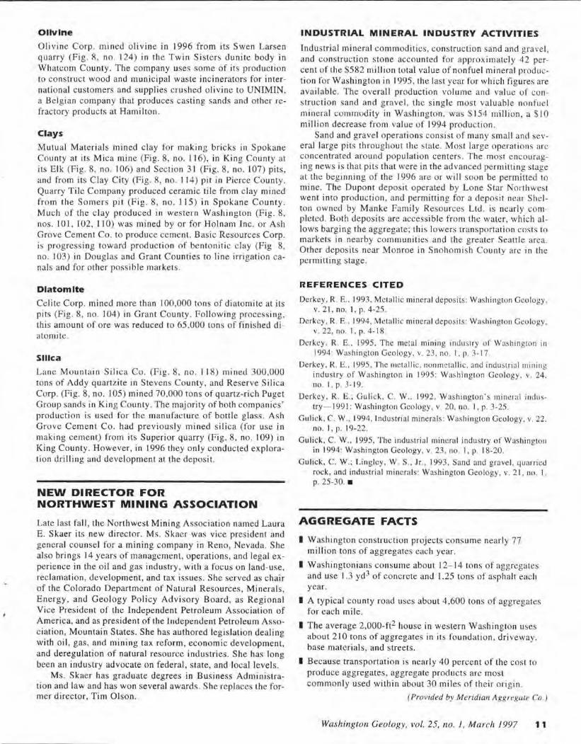
Figure 1. Highwall of clay pit. This is one of several pits where Mutual Materials Co. mines clay for making bricks at its plant in Mica, southeast of Spokane. The deposit contains about 65 percent clay, the remainder being quartz, feldspar, and mica. The non-clay fraction is about 65 percent quartz, 25-30 percent feldspar, and 5-1 O percent mica. The pit highwall shown displays considerable color variation; the darker parts are stained by limonite, an iron mineral. By carefully controlling the mix of clays from this and several other pits , the Mica plant can produce a wide spectrum of brick colors.
Figure 2. When the desired blend of source clay is reached, an appropriate amount of water is added. The clay is squeezed or forced into a mold from which it is extruded , in much the same way as toothpaste is squeezed out of its tube. The clay is extruded in a continuous stream onto a slowly moving conveyor belt. Different orifices are used to obtain the different sizes and shapes of bricks. If the design calls for holes in the brick, they are created at the orifice.
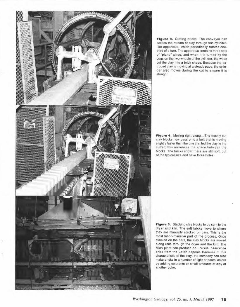
Figure 3. Cutting bricks. The conveyor belt carries the stream of clay through this cylinderlike apparatus, which periodically rotates onethird of a turn. The apparatus contains three sets of "piano" wires, and when it is turned by the cogs on the two wheels of the cylinder, the wires cut the clay into a brick shape. Because the extruded clay is moving at a steady pace, the cylinder also moves during the cut to ensure it is straight.
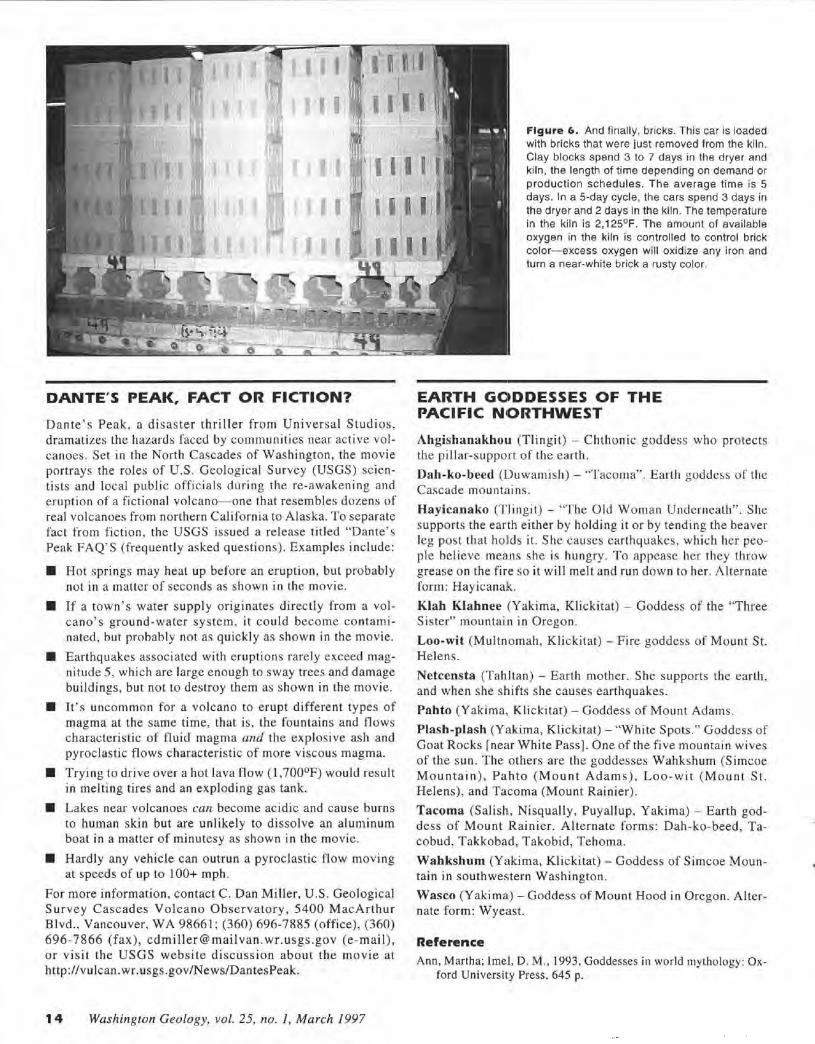
Figure 4. Moving right along .... The freshly cut clay blocks now pass onto a belt that is moving slightly faster than the one that fed the clay to the cutter; this increases the space between the blocks. The bricks shown here are still soft, but of the typical size and have three holes.
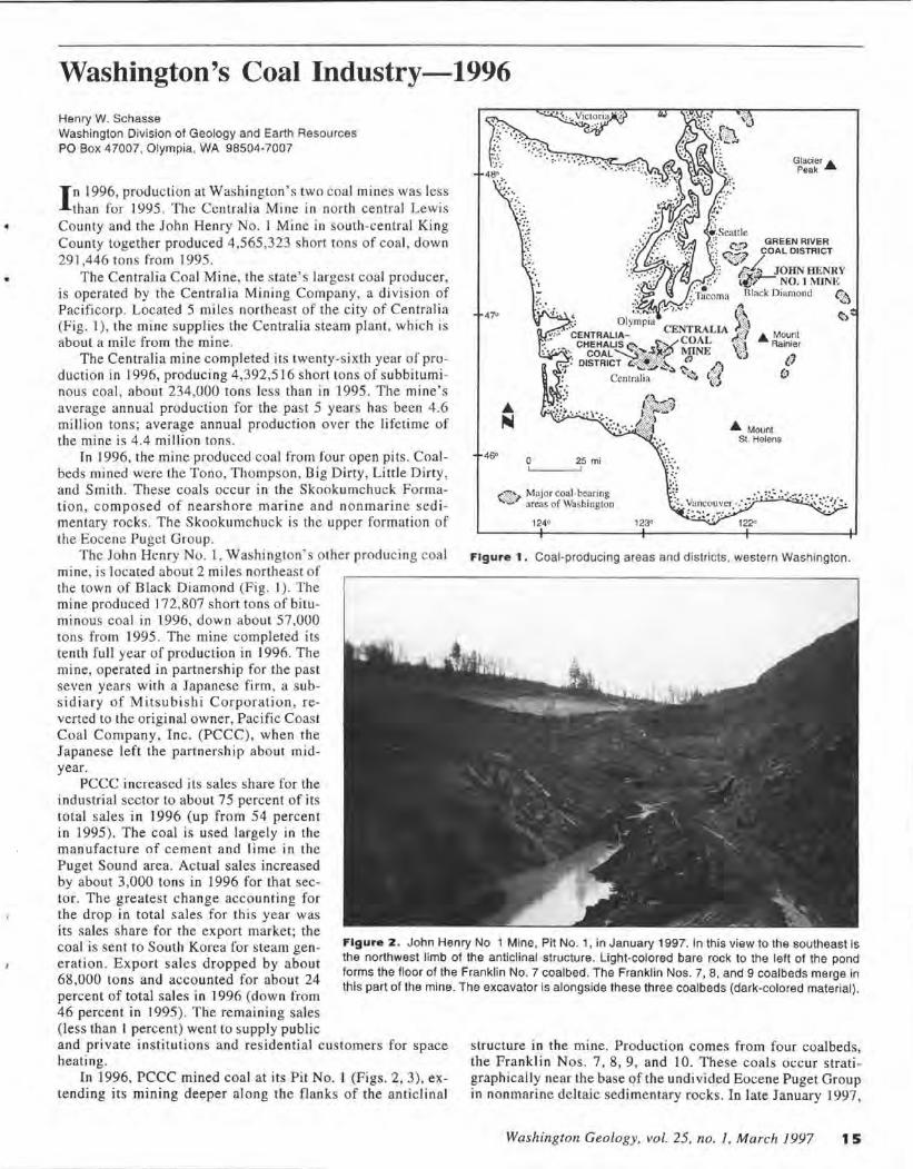
Figure 5. Stacking clay blocks to be sent to the dryer and kiln. The soft bricks move to where they are manually stacked on cars. This is the most labor-intensive part of the process. Once stacked on the cars, the clay blocks are moved along rails through the dryer and the ki ln. The Mica plant can produce an unusual near-white brick from the Latah deposit. Because of this characteristic of the clay, the company can also make bricks in a number of light or pastel colors by adding colorants or small amounts of clay of another color.
Washington Geology, vol. 25, no. 1, March 1997 13
'-0 -i-__ _
DANTE'S PEAK, FACT OR FICTION?
Dante 's Peak, a disaster thriller from Universal Studios, dramatizes the hazards faced by communities near active volcanoes. Set in the North Cascades of Washington, the movie portrays the roles of U.S. Geological Survey (USGS) scientists and local public officials during the re-awakening and eruption of a fictional volcano-one that resembles dozens of real volcanoes from northern California to Alaska. To separate fact from fiction , the USGS issued a release titled "Dante's Peak FAQ'S (frequently asked questions). Examples include:
• Hot springs may heat up before an eruption, but probably not in a matter of seconds as shown in the movie.
• If a town's water supply originates directly from a volcano's ground-water system, it could become contaminated, but probably not as quickly as shown in the movie.
• Earthquakes associated with eruptions rarely exceed magnitude 5, which are large enough to sway trees and damage buildings, but not to destroy them as shown in the movie.
• It's uncommon for a volcano to erupt different types of magma at the same time, that is, the fountains and tlows characteristic of fluid magma and the explosive ash and pyroclastic flows characteristic of more viscous magma.
• Trying to drive over a hot lava flow (l ,700°F) would result in melting tires and an exploding gas tank.
• Lakes near volcanoes can become acidic and cause burns to human skin but are unlikely to dissolve an aluminum boat in a matter of minutesy as shown in the movie.
• Hardly any vehicle can outrun a pyroclastic flow moving at speeds of up to 100+ mph.
For more information, contact C. Dan Miller, U.S. Geological Survey Cascades Volcano Observatory , 5400 MacArthur Blvd., Vancouver, WA 98661; (360) 696-7885 (office) , (360) 696-7866 (fax), [email protected] (e-mail), or visit the USGS website discussion about the movie at http://vulcan.wr.usgs.gov/N ews/DantesPeak.
14 Washington Geology, vol. 25, no. 1, March 1997
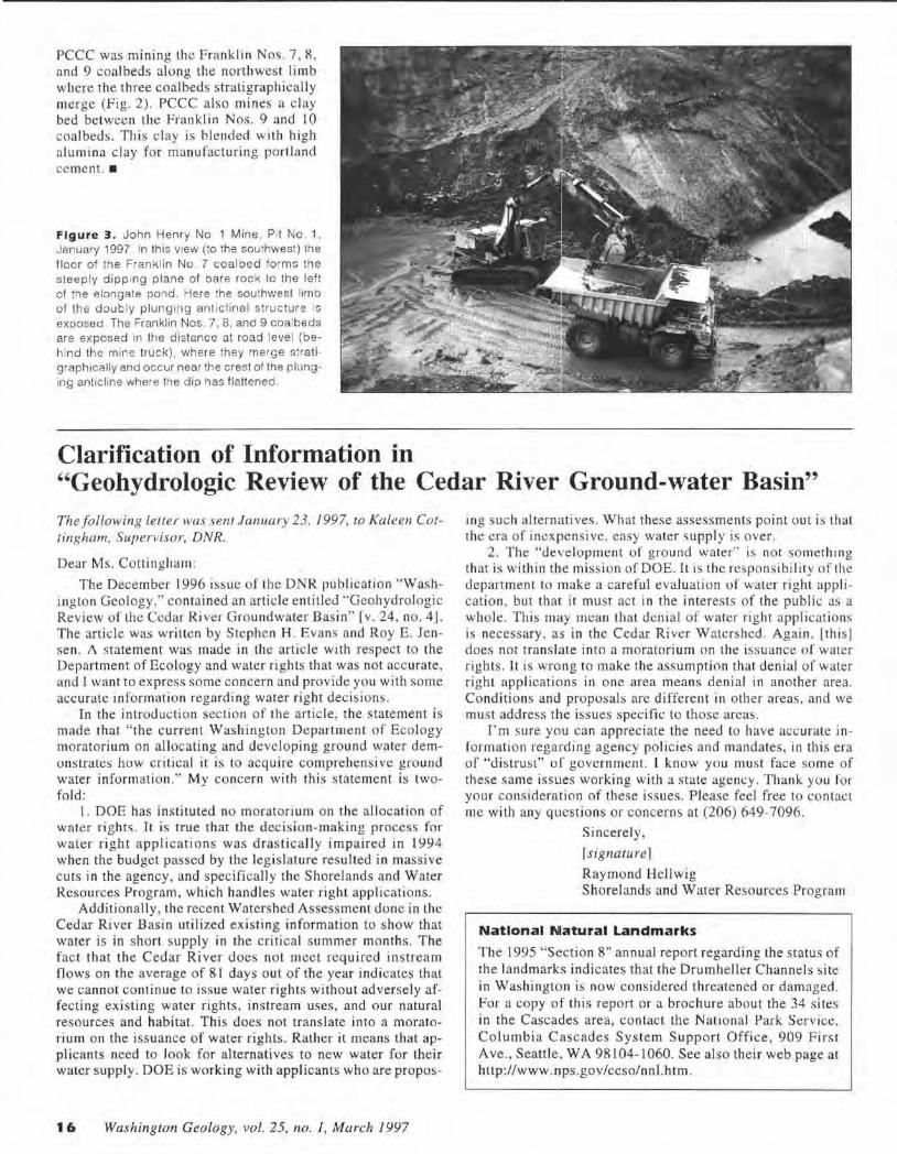
Figure 6. And finally, bricks. This car is loaded with bricks that were just removed from the kiln. Clay blocks spend 3 to 7 days in the dryer and kiln, the length of time depending on demand or production schedules. The average time is 5 days. In a 5-day cycle, the cars spend 3 days in the dryer and 2 days in the kiln. The temperature in the kiln is 2, 125°F. The amount of available oxygen in the kiln is controlled to control brick color-excess oxygen will oxidize any iron and turn a near-white brick a rusty color.
EARTH GCJ•DDESSES OF THE PACIFIC N10RTHWEST
Ahgishanakhou (Tlingit) - Chthonic goddess who protects the pillar-support of the earth.
Dah-ko-beed (Duwamish) - "Tacoma". Earth goddess of the Cascade mountains .
Hayicanako (Tlingit) - "The Old Woman Underneath". She supports the earth either by holding it or by tending the beaver leg post that holds it. She causes earthquakes, which her people believe means she is hungry. To appease her they throw grease on the fire so it will melt and run down to her. Alternate form: Hayicanak.
Kiah Klahnee (Yakima, Klickitat) - Goddess of the "Three Sister" mountain in Oregon.
Loo-wit (Multnomah, Klickitat) - Fire goddess of Mount St. Helens.
Netcensta (Tahltan) - Earth mother. She supports the earth , and when she shifts she causes earthquakes.
Pabto (Yakima, Klickitat) - Goddess of Mount Adams.
Plash-plash (Yakima, Klickitat) - "White Spots." Goddess of Goat Rocks [near White Pass]. One of the five mountain wives of the sun. T he others are the goddesses Wahkshum (S imcoe M o untain ), Pahto (Mount Adams). Loo-wit (Mount St. Helens), and Tacoma (Mount Rainier).
Tacoma (Salish, Nisqually, Puyallup, Yakima) - Earth goddess of Mount Rainier. Alternate forms : Dah-ko-beed, Tacobud, Takkobad, Takobid, Tehama.
Wahkshum (Yakima, Klickitat) - Goddess of Simcoe Mountain in southwestern Washington.
Wasco (Yakima) - Goddess of Mount Hood in Oregon. Alternate form: Wyeast.
Reference Ann, Martha; Imel, D. M., 1993, Goddesses in world mythology: Ox
ford University Press, 645 p.
Washington's Coal Industry-1996 Henry W. Schasse Washington Division of Geology and Earth Resources PO Box 47007, Olympia, WA 98504-7007
In 1996, production at Washington's two coal mines was less than for 1995 . The Centralia Mine in north central Lewis
County and the John Henry No. 1 Mine in south-central King County together produced 4 ,565,323 short tons of coal, down 291,446 tons from 1995.
The Centralia Coal Mine, the state's largest coal producer, is operated by the Centralia Mining Company, a di vision of Pacificorp. Located 5 miles northeas t of the city of Centralia (Fig. 1), the mine supplies the Centralia steam plant, which is about a mile from the mine.
The Centralia mine completed its twenty-sixth year of production in I 996, producing 4 ,392,516 short tons of subbituminous coal, about 234,000 tons less than in 1995. The mine's average annual production for the past 5 years has been 4 .6 million tons; average annual production over the lifetime of the mine is 4.4 million tons.
In 1996, the mine produced coal from four open pits. Coalbeds mined were the Tono, Thompson, Big Dirty, Little Dirty, and Smith. These coals occur in the Skookumchuck Formation , composed of nearshore marine and nonmarine sed imentary rocks. The Skookumchuck is the upper formation of the Eocene Puget Group.
The John Henry No. I , Washington's other produci ng coal mine, is located about 2 miles northeast of the town of Black Diamond (Fig. I) . The mine produced 172,807 short tons of bituminous coal in 1996, down about 57,000 tons from 1995. The mine completed its tenth full year of production in 1996. The mine, operated in partnership for the past seven years with a Japanese firm, a subs idiary of Mitsubishi Corporation, reverted to the original owner, Pacific Coast Coal Company, Inc. (PCCC), when the Japanese left the partnership about midyear.
47°
0 25 mi
,,.1:;~ Maj or coal-bearing ""· ... ~ areas of Washington
124° 123°
.6. Mount St. Helens
122"
Figure 1 . Coal-producing areas and districts, western Washington.
PCCC increased its sales share for the industrial sector to about 7 5 percent of its total sales in 1996 (up from 54 percent in 1995). The coal is used largely in the manufacture of cement and lime in the Puget Sound area. Actual sales increased by about 3,000 tons in 1996 for that sector. The greatest change accounting for the drop in total sales for this year was its sales share for the export market; the coal is sent to South Korea for steam generation . Export sales dropped by about 68,000 tons and accounted for about 24 percent of total sales in 1996 (down from 46 percent in 1995). The remaining sales
Figure z. John Henry No 1 Mine, Pit No. 1, in January 1997. In this view to the southeast is the northwest limb of the anticlinal structure. Light-colored bare rock to the left of the pond forms the floor of the Franklin No. 7 coalbed. The Franklin Nos. 7, B, and 9 coalbeds merge in this part of the mine. The excavator is alongside these three coalbeds (dark-colored material).
(less than 1 percent) went to supply public and private institutions and residential customers for space heating.
In 1996, PCCC mined coal at its Pit No. l (Figs. 2, 3), extending its mining deeper along the flanks of the anticlinal
structure in the mine. Production comes from four coalbeds, the Franklin Nos. 7, 8, 9, and 10. These coals occur stratigraphically near the base of the undivided Eocene Puget Group in nonmarine deltaic sedimentary rocks . In late January 1997,
Washington Geology, vol. 25, no. 1, March 1997 15
PCCC was mining the Franklin Nos. 7, 8, and 9 coalbeds a long the northwest limb where the three coalbeds stratigraphically merge (Fig. 2). PCCC also mines a c lay bed between the Franklin Nos. 9 and 10 coalbeds. Thi s c lay is blended with high alumi na clay for manufacturing portland cement. •
Figure 3. John Henry No 1 Mine , Pit No 1, January 1997. In this view (to the southwest) the floor of th e Franklin No . 7 coalbed fo rms the steeply dipping plane of bare rock to the left of the elongate pond. Here the southwest limb of the doub ly plunging anticlinal structure 1s exposed. The Franklin Nos. 7, 8 , and 9 coalbeds are exposed in the distance at road leve l (behind the mine tru ck). where they merge strati graphically and occur near the crest of the plunging anticline where the dip has flattened .
Clarification of Information in "Geohydrologic Review of the Cedar River Ground-water Basin" The following letter was se/ll January 23, 1997, to Kalee11 Cottingham, Supervisor, DNR.
Dear Ms. Cottingham :
The December 1996 issue of the DNR publi cati on "Washington Geology." con tai ned an article enti tled "Geohydrologic Review of the Cedar River Groundwater Basi n" [v. 24. no. 4] . The article was written by Stephen H. Evans and Roy E. Jensen. A statement was made in the article with respect to the Department of Ecology and water rights that was not accurate, and I want to express some concern and provide you with some accurate informatio n regarding water right decisions.
In the introduc tion section of the artic le, the statement is made that " the current Washington Department of Ecology moratorium on allocating and developing ground water demons trates how critica l it is to acquire comprehensive ground water information." My concern with this statement is twofo ld:
I . DOE has ins tituted no moratorium on the a lloca tion of water rights. It is true that the decis io n-making process for water right a pplic atio ns was drastically impaired in 1994 when the budget passed by the legis lature resulted in massive cuts in the agency, and specifically the Shorelands and Water Resources Program, which handles water righ t applications.
Additionally, the recent Watershed Assessment done in the Cedar River Basin utilized ex isting information to show that water is in short supply in the critical summer months. The fact that the Cedar River does not meet required ins tream flows on the average of 8 1 days out o f the year indicates that we cannot continue to issue water rights without adversely affecting existing water rights, instream uses, and our natural resources and habitat. This does no t translate into a moratorium on the issuance of water rights. Rather it means that applicants need to look for alternatives to new water for their water s upply. DOE is working with applicants who are propos-
16 Washington Geology, vol. 25, no. J, March 1997
ing s uch a lternatives. What these assessments point out is that the era of inexpensive, easy water suppl y is over.
2 . The "development of ground water" is not something th at is wi thin the mission of DOE. It is the responsibility of the department to make a careful evaluation of water right application. but that it must act in the interests of the public as a who le. This may mean that denial of water right appl ications is necessary, as in the Cedar Ri ver Watershed . Again , [this] does not transla te into a moratorium on the issuance of water rights. lt is wrong to make the assumption that denial of water right applications in one area means denial in another area. Conditions and proposals are different in other areas , and we must address the issues specific to those areas.
I'm sure you can appreciate the need to have accurate information regarding age ncy policies and mandates, in this era of "distrust" of government. I know you must face some of these same issues working with a state agem:y . T hank you ror your considera tion of these issues. Please feel free to contact me with any questions or concerns at (206) 649-7096.
Sincerely,
r signature 1 Raymond Hellwig Sho re lands and Water Resources Program
Natlonal Nlatural Landmarks
The 1995 "Section 8" ann ual report regarding the status of the landmarks indicates that the Drumheller Channels s ite in Washington is now considered threate ned o r damaged . For a copy of thi s report or a brochure abou t the 34 s ites in the Cascades area, contact the National Park Service, Columbia Cascades System Support Office, 909 First Ave., Seattle, WA 98104- 1060. See also their web page at http://www.nps.gov/ccso/nnl .htm .
Puget Sound Bluffs: The Where, Why, and When of Landslides Following the Holiday 1996/97 Storms Wendy J. Gerste1 1
, Matthew J. Brunengo2, William S. Lingley, Jr. 1
, Robert L. Logan 1, Hugh Shipman3, and Timothy J. Walsh 1
1 Washington Department of Natural Resources Division of Geology and Earth Resources
2 Washington Department of Natural Resources Forest Practices Division
3 Washington Department of Ecology Northwest Regional Office
P.O. Box 47007 P.O. Box 47012 31390 160th Ave SE Olympia, WA 98504-7007 Olympia, WA 98504-7012 Bellevue, WA 98008-5452
From late December 1996 to early January 1997 , a series of winter storms delivered snow, freezing rain , warm rain,
and wind to the west coast, produc ing flood s, snow and ice damage, and landslides from Washington to central California. Individual weather sys tems like these arrive almost annually; the consequences of their combination are somewhat more remarkable, but nonetheless occur every few years somewhere in the region. The region' s long history of slope failure following heavy precipitation events is di scussed in Tubbs (1974), Thorsen ( 1987), Miller ( 1991), and Eva.ts (1994).
Tn the Pacifi c Northwest , the autumn months had abovenormal precipitation, building hig h soil moisture and heavy snowpacks. In late December, a cold continental air mass sat over northwest Washington, while a seri es of warm wet storms began moving in from the Pacific Ocean. The incoming moisture first fell as snow north of the cold front and freezing rain south of it. Jn the southern Puget Sound region and the Columbia Gorge-Portland area, ice storms brought down trees and power lines, while s now acc umulated from abo ut Olympia northward, reaching depths of up to 3 fl in north King County.
Then on January I and 2, warm air, combined with locally heavy ra ins, quickly melted much of the low-elevation snow. This caused flooding in most streams in the Puget Lowland and in many of the rivers draining the Olympics and the Cascades.
The combination of pre-existing soil moisture, heavy rain, and rapid snowmelt brought soils to or near saturation. This had different effects, depending on the terrain . On the gentler drift plain s, perc hing of water on till s and emergence of ground water from shallow aquifers caused lingering flooding of low- ly ing areas. But in the steep bluffs and ravines that border Puget Sound, Lake Washington , and the larger river valleys, lateral movement of ground water toward the free faces caused elevated pore-water pressures that triggered hundreds of lands lides. A selection of these landslides are presented in thi s report.
Following a disaster declaration by President Clinton for most counties in Washington, the Federal Emergency Management Agency (FEMA) made funds available for identification , investigation, and remediation o f the landslides , among other emergency needs. Division of Geology and Earth Resources geologists were asked by the Washington State Emergency Management Di vision to help the City of Seattle with damage assessment. Helicopter flights and several days of on-theground visits provided an overview of storm effects. T he Division submitLed oral and written reports to the City of Seattle and worked with other local geologists and landslide experts to examine new s lides and slide-prone areas that threatened structures and transportation corridors. At the same time, private consultants assisted homeowners in repairing the damage and provided adv ice on slope stabilization techniques .
ll11y
Figs. 12, 22--26, 29
lukt> Wa.1/1111s tun
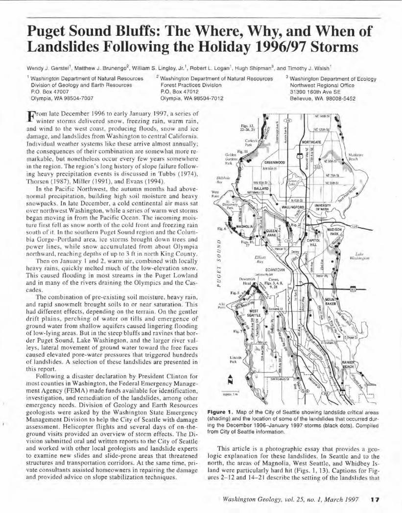
Figure 1. Map of the City of Seattle showing landslide critical areas (shading) and the location of some of the landslides that occurred during the December 1996-January 1997 storms (black dots). Compiled from City of Seattle information.
This article is a photographic essay that provides a geologic explanation for these landslides. In Seattle and to the north , the areas of Magnolia, West Seattle, and Whidbey Island were particularly hard hit (Figs. I, 13) . Captions for Figures 2- 12 and 14-2 1 describe the setting of the lands I ides that
Washington Geology, vol. 25, no. 1, March 1997 17
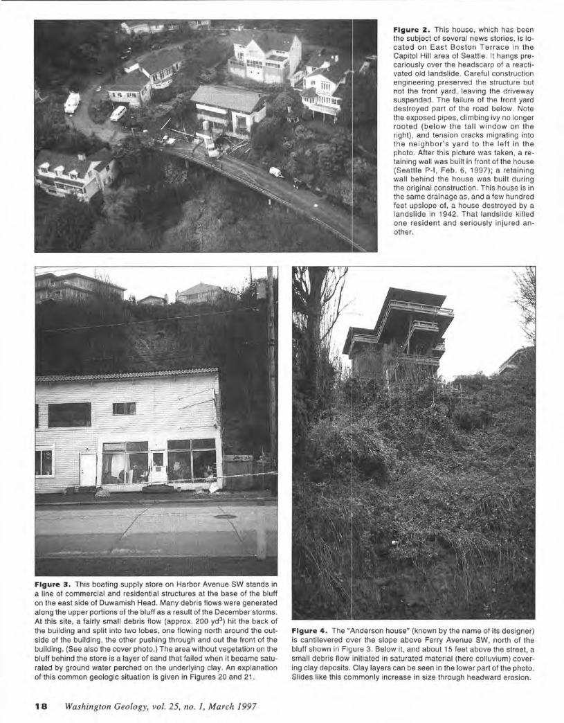
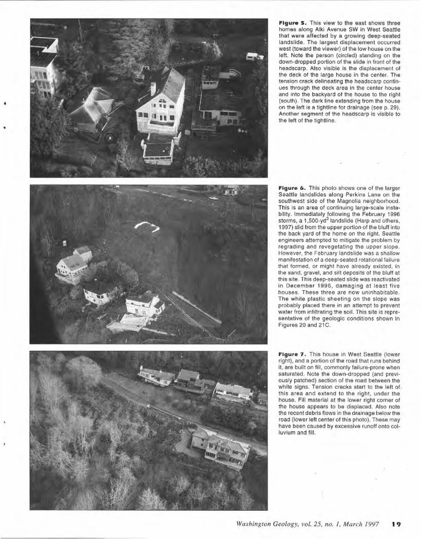
Figure 3. This boating supply store on Harbor Avenue SW stands in a line of commercial and residential structures at the base of the bluff on the east side of Duwamish Head. Many debris flows were generated along the upper portions of the bluff as a result of the December storms. At this site, a fairly small debris flow (approx. 200 yd3
) hit the back of the building and split into two lobes, one flowing north around the outside of the building, the other pushing through and out the front of the building. (See also the cover photo.) The area without vegetation on the bluff behind the store is a layer of sand that failed when it became saturated by ground water perched on the underlying clay. An explanation of this common geologic situation is given in Figures 20 and 21.
18 Washington Geology, vol. 25, 110. 1, March 1997
Figure 2. This house, which has been the subject of several news stories, is located on East Boston Terrace in the Capitol Hill area of Seattle. It hangs precariously over the headscarp of a reactivated old landslide. Careful construction engineering preserved the structure but not the front yard, leaving the driveway suspended. The failure of the front yard destroyed part of the road below. Note the exposed pipes, climbing ivy no longer rooted (below the tall window on the right), and tension cracks migrating into the neighbor's yard to the left in the photo. Alter this picture was taken, a retaining wall was built in front of the house (Seattle P-1 , Feb. 6, 1997); a retaining wall behind the house was built during the original construction . This house is in the same drainage as, and a few hundred feet upslope of, a house destroyed by a landslide in 1942. That landslide killed one resident and seriously injured another.
Figure 4. The "Anderson house" (known by the name of its designer) is cantilevered over the slope above Ferry Avenue SW, north of the bluff shown in Figure 3. Below it, and about 15 feet above the street, a small debris flow initiated in saturated material (here colluvium) covering clay deposits. Clay layers can be seen in the lower part of the photo. Slides like this commonly increase in size through headward erosion.
4
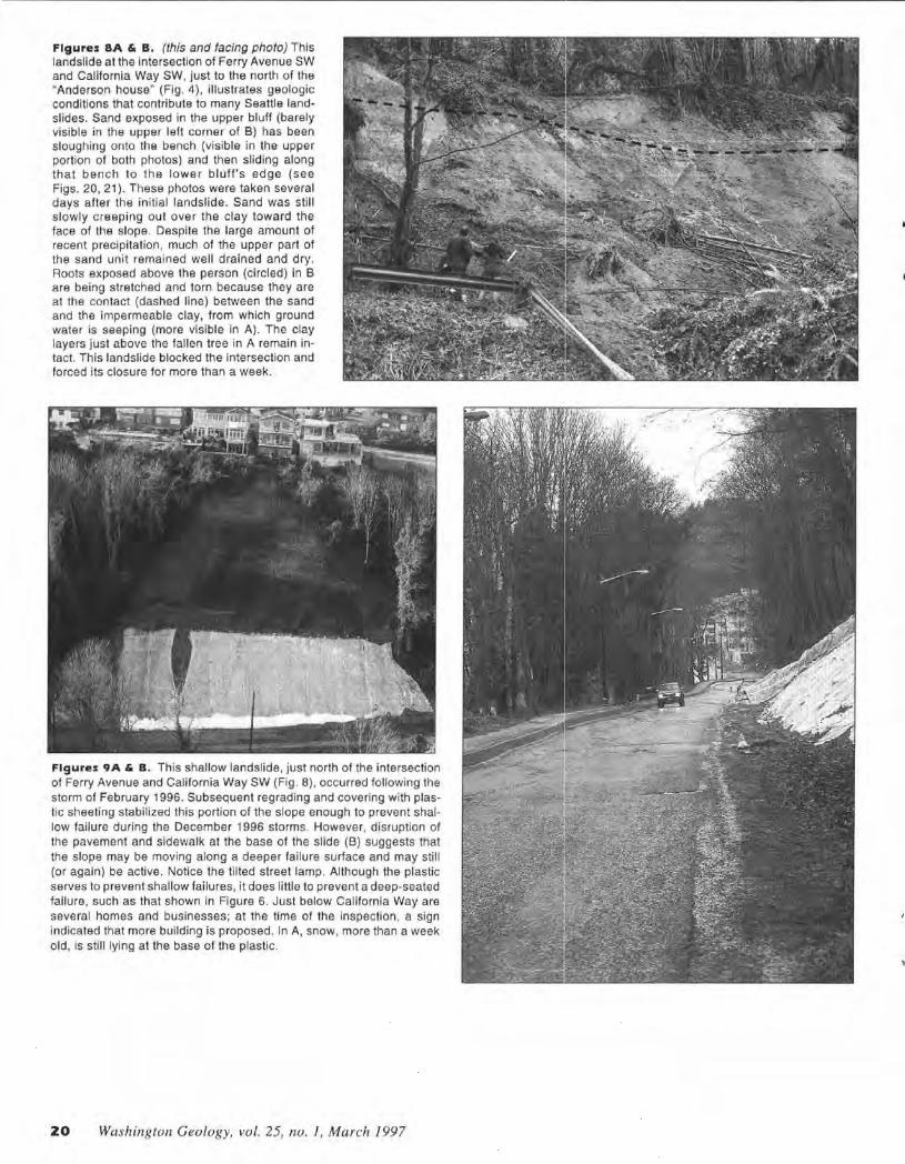
Figure s. This view to the east shows three homes along Alki Avenue SW in West Seattle that were affected by a growing deep-seated landslide. The largest displacement occurred west (toward the viewer) of the low house on the left. Note the person (circled) standing on the down-dropped portion of the slide in front of the headscarp. Also visible is the displacement of the deck of the large house in the center. The tension crack delineating the headscarp continues through the deck area in the center house and into the backyard of the house to the right (south) . The dark line extending from the house on the left is a tightline for drainage (see p. 29) . Another segment of the headscarp is visible to the left of the tightl ine.
Figure 6. This photo shows one of the larger Seattle landslides along Perkins Lane on the southwest side of the Magnolia neighborhood. This is an area of continuing large-scale instability. Immediately following the February 1996 storms, a 1,500-yd3 landslide (Harp and others, 1997) slid from the upper portion of the bluff into the back yard of the home on the right. Seattle engineers attempted to mitigate the problem by regrading and revegetating the upper slope. However, the February landslide was a shallow manifestation of a deep-seated rotational failure that formed, or might have already existed, in the sand, gravel, and silt deposits of the bluff at this site. This deep-seated slide was reactivated in December 1996, damaging at least five houses. These three are now uninhabitable. The white plastic sheeting on the slope was probably placed there in an attempt to prevent water from infiltrating the soil. This site is representative of the geologic conditions shown in Figures 20 and 21 C.
Figure 7. This house in West Seattle (lower right), and a portion of the road that runs behind it, are built on fill , commonly failure-prone when saturated. Note the down-dropped (and previously patched) section of the road between the white signs. Tension cracks start to the left of . this area and extend to the right, under the house. Fill material at the lower right corner of the house appears to be displaced. Also note the recent debris flows in the drainage below the road (lower left center of this photo). These may have been caused by excessive runoff onto colluvium and fill.
Washington Geology, vol. 25, no. }, March 1997 19
Figures BA & B. (this and facing photo) This landslide at the intersection of Ferry Avenue SW and California Way SW, just to the north of the "Anderson house" (Fig. 4) , illustrates geologic conditions that contribute to many Seattle landslides. Sand exposed in the upper bluff (barely visible in the upper left corner of B) has been sloughing onto the bench (visible in the upper portion of both photos) and then sliding along that bench to the lower bluff's edge (see Figs. 20, 21 ). These photos were taken several days after the initial landslide. Sand was still slowly creeping out over the clay toward the face of the slope. Despite the large amount of recent precipitation, much of the upper part of the sand unit remained well drained and dry. Roots exposed above the person (circled) in B are being stretched and torn because they are at the contact (dashed line) between the sand and the impermeable clay, from which ground water is seeping (more visible in A) . The clay layers just above the fallen tree in A remain intact. This landslide blocked the intersection and forced its closure for more than a week.
Figures 9A & B. This shallow landslide, just north of the intersection of Ferry Avenue and California Way SW (Fig. 8), occurred following the storm of February 1996. Subsequent regrading and covering with plastic sheeting stabilized this portion of the slope enough to prevent shallow failure during the December 1996 storms. However, disruption of the pavement and sidewalk at the base of the slide (B) suggests that the slope may be moving along a deeper failure surface and may sti ll (or again) be active. Notice the tilted street lamp. Although the plastic serves to prevent shallow failures , it does little to prevent a deep-seated failure, such as that shown in Figure 6. Just below California Way are several homes and businesses; at the time of the Inspection , a sign indicated that more building is proposed. In A, snow, more than a week old, is still lying at the base of the plastic.
ZO Wa shington Geology, vol. 25, no. l , March 1997
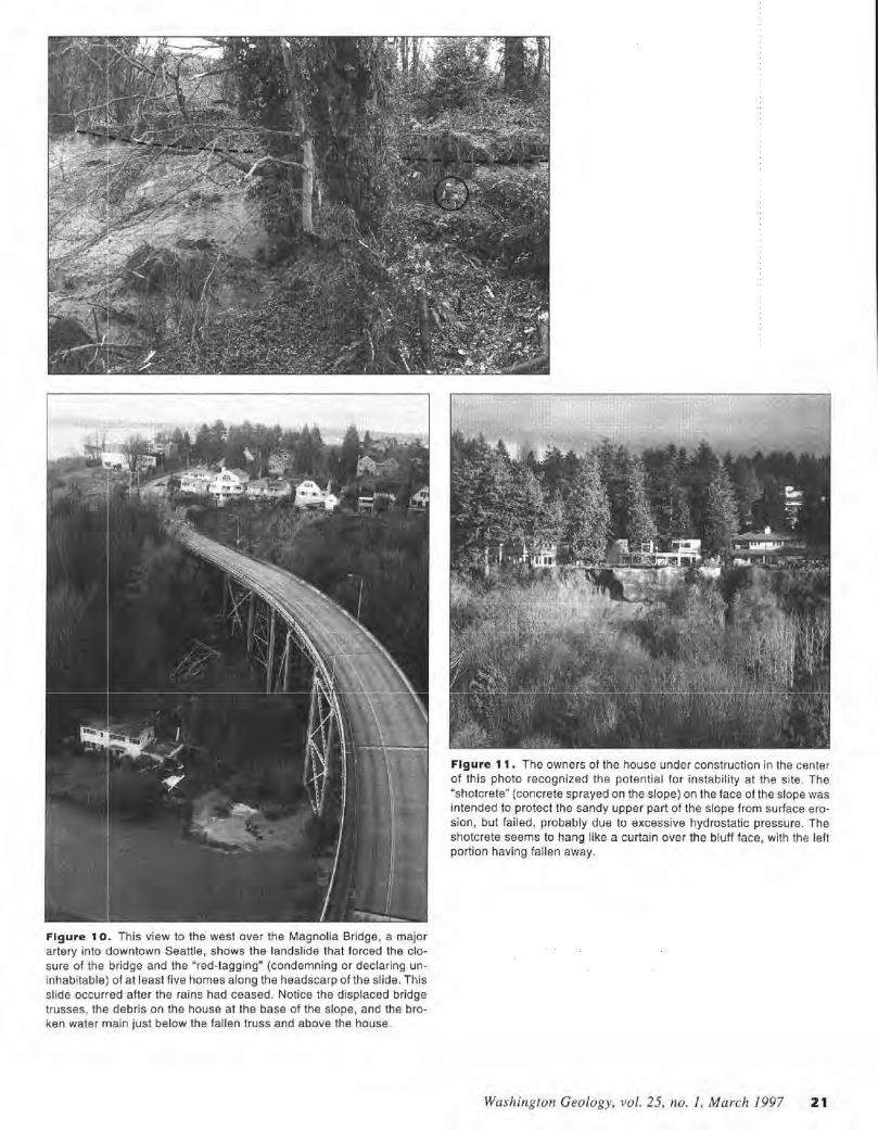
Figure 1 o. This view to the west over the Magnolia Bridge, a major artery into 1jowntown Seattle, shows the landslide that forced the closure of the bridge and the "red-tagging" (condemning or declaring uninhabitable) of at least five homes along the headscarp of the slide. This slide occurred after the rains had ceased. Notice the displaced bridge trusses, the, debris on the house at the base of the slope, and the broken water main just below the fallen truss and above the house.
Figure 11. The owners of the house under construction in the center of this photo recognized the potential for instability at the site. The "shotcrete" (concrete sprayed on the slope) on the face of the slope was intended to protect the sandy upper part of the slope from surface erosion, but failed, probably due to excessive hydrostatic pressure. The shotcrete seems to hang like a curtain over the bluff face, with the left portion having fallen away.
Washington Geology, vol. 25, no. 1, March 1997 21
48°
123°
JEFFERSON COUNTY
approx. 4 ml
ZZ Washington Geology, vol. 25, no. 1, March 1997
SNOHOMISH COUNTY
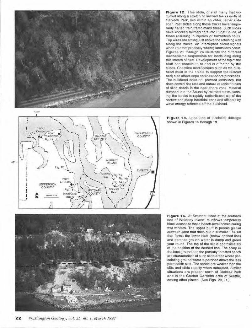
Figure 1 z. This slide , one of many that occurred along a stretch of railroad tracks north of Carkeek Park, lies within an older, larger slide scar. Past slides along these tracks have temporarily halted train traffic many times. Such slides have knocked railroad cars into Puget Sound, at times resulting in injuries or hazardous spills . Trip wires are strung just above the retaining wal l along the tracks. An interrupted ci rcuit signals when (but not precisely where) landslides occur. Figures 21 through 26 illustrate the different mechanisms responsible for landsliding along this stretch of bluff. Development at the top of the bluff can contribute to and is affected by the slides. Coastline modifications such as the bulkhead (built in the 1890s to support the railroad bed) also affect slope and near-shore processes. The bulkhead does not prevent landslides, but does control the rate and nature of redistribution of slide debris in the near-shore zone. Material dumped into the Sound by railroad crews cleaning the tracks is rapidly redistributed out of the narrow and steep intertidal zone and offshore by wave energy reflected off the bulkhead.
Figure 13. Locations of landslide damage shown in Figures 14 through 19.
Figure 1 4. At Scatchet Head at the southern end of Whidbey Island, mudflows temporarily block access to these beach-level homes during wet winters. The upper bluff is porous glacial outwash sand that dries out in summer. The silt that forms the lower bluff (below dashed line) and perches ground water is damp and green year round. The top of the silt is approximately at the position of the dashed line. The scarp in the background and the partially forested bench are characteristic of such slide areas where percolating ground water is perched above the less permeable silts. The sands are weaker than the slits and slide readily when saturated. Similar situations are present north of Carkeek Park and in the Golden Gardens area of Seattle, among other places. (See Figs. 20, 21.)
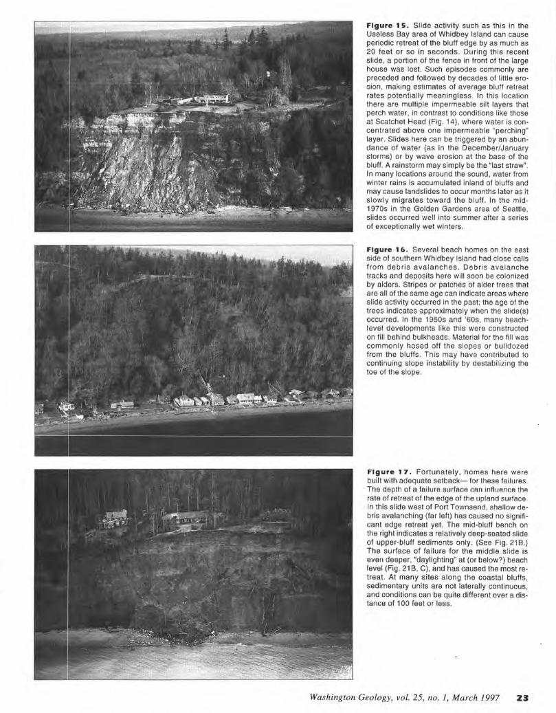
Figure 1 5. Slide activity such as this in the Useless Bay area of Whidbey Island can cause periodic retreat of the bluff edge by as much as 20 feet or so in seconds. During this recent slide, a portion of the fence in front of the large house was lost. Such episodes commonly are preceded and followed by decades of little ero· sion, making estimates of average bluff retreat rates potentially meaningless. In this location there are multiple impermeable silt layers that perch water, in contrast to conditions like those at Scatchet Head (Fig. 14), where water is concentrated above one impermeable "perching" layer. Slides here can be triggered by an abundance of water (as in the December/January storms) or by wave erosion at the base of the bluff. A rainstorm may simply be the "last straw". In many locations around the sound, water from winter rains is accumulated inland of bluffs and may cause landslides to occur months later as it slowly migrates toward the bluff. In the mid-1970s in the Golden Gardens area of Seattle, slides occurred well into summer after a series of exceptionally wet winters.
Figure 16. Several beach homes on the east side of southern Whidbey Island had close calls from debris avalanches. Debris avalanche tracks and deposits here will soon be colonized by alders. Stripes or patches of alder trees that are all of the same age can indicate areas where slide activity occurred in the past; the age of the trees indicates approximately when the slide(s) occurred. In the 1950s and '60s, many beachlevel developments like this were constructed on fill behind bulkheads. Material for the fill was commonly hosed off the slopes or bulldozed from the bluffs. This may have contributed to continuing slope instability by destabilizing the toe of the slope.
Figure 17. Fortunately, homes here were built with adequate setback- for these failures . The depth of a failure surface can influence the rate of retreat of the edge of the upland surface. In this slide west of Port Townsend, shallow debris avalanching (far left) has caused no significant edge retreat yet. The mid-bluff bench on the right indicates a relatively deep-seated slide of upper-bluff sediments only. (See Fig. 21 B.) The surface of failure for the middle slide is even deeper, "daylighting" at (or below?) beach level (Fig. 21 B, C), and has caused the most retreat. At many sites along the coastal bluffs, sedimentary units are not laterally continuous, and conditions can be quite different over a distance of 100 feet or less.
Washington Geology, vol. 25, no. 1, March 1997 23
Figures 1 9A & B. Continuing slide activity has made this home near Cape George in Jefferson County uninhabitable. At this site , the perching layer is a small area of ancient lakebed silt that lies beneath the house at about mid-bluff level, now covered with grass dropped from the back lawn. This part of the bluff remains green year round . Note the old slide mass at beach level (lower left) , now covered by alder trees that are all of approximately the same age (here, perhaps 25 years old) . Also note the arcuate line of boulders seaward of these trees. Such a pattern of boulders, which are commonly accompanied by steeply tilted silt and clay beds, can indicate an old slide surface at or below beach level. B. (right) This closeup shows recent slide debris on the bench, as well as the exposed septic tank (the white rectangle below the right side of the house and drainfield pipe in A); the tank has since fallen to the beach. Poorly located septic systems often contribute to slope instability . The dark strata at the upper part of the bluff are gravels and are not saturated here. It is possible that dralnfield effluent percolated downward and blullward to destabilize this slope or that deeper ground water caused the problem at this location. Wave erosion has likely been a contributor at this site as well. Trying to maximize a view by building close to the bluff line can be a costly and potentially hazardous mistake.
24 Washington Geology, vol. 25, no. I. March 1997
Figure 18. This shoreline home between the Hood Canal Bridge and Port Ludlow lost its front yard during the December/January rainstorms and snowmelt. Bedrock exposed on the beach below the bluff shown in this photo was resistant to wave erosion. However, the glacially polished bedrock perched ground water in the gravelly sand above the steeply sloping contact here. Runoff from rapid snowmelt was apparently funneled down the driveway from upslope development. The area to the left of this landslide (out of view) was probably buttressed by a large maple stump kept alive by sprouts. (The area still farther left also failed.) Glacial ly compacted silts or bedrock form a barrier to roots and ground water . Where this condition exists in the Puget Lowland , shallow debris avalanches can be common . The overlying permeable saturated soil cannot be anchored to the substrate by the weak toeho ld of the roots of trees and other vegetation.
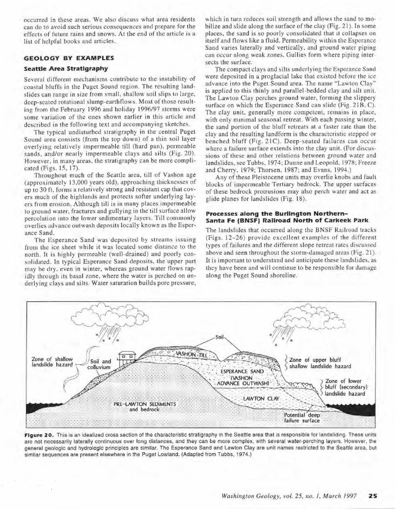
occurred in these areas. We also discuss what area residents can do to avoid such serious consequences and prepare for the effects of future rains and snows. At the end of the article is a list of helpful books and articles.
GEOLOGY BY EXAMPLES
Seattle Area Stratigraphy
Several d ifferent mechanisms contribute to the instabi lity of coastal bluffs in the Puget Sound region. The resulting lands lides can range in size from small, shallow soil s lips to large, deep-seated rotational slump-earthflows. Most of those resulting from the February 1996 and holiday 1996/97 storms were some variation of the ones shown earlier in this article and described in the following text and accompanying sketches.
The typical undisturbed stratigraphy in the central Puget Sound area consists (from the top down) of a thin soil layer overlying relat ively impermeable till (hard pan), permeable sands, and/or nearly impermeable c lays and silts (Fig. 20). However, in many areas , the stratigraphy can be more complicated (Figs. 15, 17).
Throughout much of the Seattle area, till of Vashon age (approximately 13,000 years old), approaching thicknesses of up to 30 ft, forms a relatively strong and resistant cap that covers much of the highlands and protects softer underlying layers from erosion. Although till is in many places impermeable to ground water, fractures and gullying in the till su rface allow percolation into the lower sedimentary layers. Till commonly overlies advance outwash deposits locally known as the Esperance Sand.
The Esperance Sand was deposited by s treams issuing from the ice sheet whi le it was located some distance to the north. It is highly permeable (well-drained) and poorly conso lidated. In typical Esperance Sand deposits, the upper part may be dry , even in winter, whereas ground water flows rapidly through its basal zone, where the water is perched on underlying c lays and silts. Water saturation builds pore pressure,
Zone of shallow landslide hazard
which in turn reduces soil strength and al lows the sand to mobilize and slide along the surface of the clay (Fig. 21 ). In some places, the sand is so poorly consolidated that i t col lapses on itself and flows like a fluid . Permeability withi n the Esperance Sand varies laterally and vertically, and ground water pip ing can occur along weak zones. Gullies form where piping intersects the surface .
The compact clays and si lts underlying the Esperance Sand were deposited in a proglacial lake that existed before the ice advance into the Puget Sound area. The name "Lawton Clay" is applied to thi s thinly and parallel-bedded c lay and s ilt unit. The Lawton C lay pe rches ground water, form ing the s lippery surface on which the Esperance Sand can sl ide (Fig. 218, C). The clay unit, generally more competent, remains in place, with only minimal seasonal retreat. With each passing winter, the sand portion of the bluff retreats at a faster rate than the clay and the resulting landform is the characteristic stepped or benched bluff (Fig. 2 1 C). Deep-seated failures ca n occu r where a failure surface extends into the c lay unit. (For discussions of these and other relations between ground water and landslides, see Tubbs, 1974; Dunne and Leopold, 1978; Freeze and Cherry, 1979; Thorsen, 1987 ; and Evans, 1994.)
Any of these Pleistocene units may overlie knobs and faull blocks of impermeable Tertiary bedrock. The upper surfaces of these bedrock protrusions may also perch water and act as glide planes for landslides (Fig. 18).
Processes along the Burllngton Northern-Santa Fe (BNSF) Rallroad North of Carkeek Park
The landslides that occurred along the BNSF Railroad tracks (Figs . 12-26) provide excel le nt examp Jes of the different types of failures and the different slope retreat rates discussed above and seen throughout the storm-damaged areas (Fig. 21 ). It is important to understand and anticipate these landslides, as they have been and will continue to be responsible for damage along the Puget Sound shoreline.
~ Zone of upper bluff S shallow landslide hazard
~ Zone of lower bluff (secondary)
- - : - : - :: - - - - - - - - - - - - :>,: - : - = -: - landslide hazard : : :: : L~~.!?-~ -~L_A~_:: : : ::='°:~ .:~:: : _ -_- ___________ ____ .:--:.~
------
Figure zo. This is an idealized cross section of the characteristic stratigraphy in the Seattle area that is responsible for landsliding. These units are not necessarily laterally continuous over long distances, and they can be more complex, with several water-perching layers. However, the general geologic and hydrologic principles are similar. The Esperance Sand and Lawton Clay are unit names restricted to the Seattle area, but similar sequences are present elsewhere in the Puget Lowland. (Adapted from Tubbs, 1974.)
Washington Geology, vol. 25, no. 1, March 1997 25
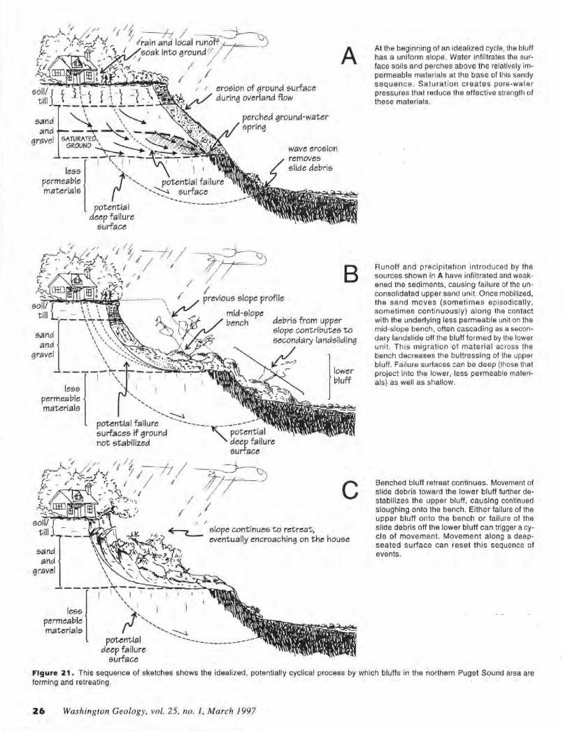
/
I I
A
B
C slope continues to retreat, eventually encroaching on the house
At the beginning of an idealized cycle, the bluff has a uniform slope. Water infiltrates the surface soils and perches above the relatively impermeable materials at the base of this sandy sequence. Saturation creates pore-water pressures that reduce the effective strength of these materials.
Runoff and precipitation introduced by the sources shown in A have infiltrated and weakened the sediments, causing failure of the unconsolidated upper sand unit. Once mobilized, the sand moves (sometimes episodically, sometimes continuously) along the contact with the underlying less permeable unit on the mid-slope bench, often cascading as a secondary landslide off the bluff formed by the lower unit. This migration of material across the bench decreases the buttressing of the upper bluff. Failure surfaces can be deep (those that project into the lower. less permeable materials) as well as shallow.
Benched bluff retreat continues. Movement of slide debris toward the lower bluff further destabilizes the upper bluff, causing continued sloughing onto the bench. Either failure of the upper bluff onto the bench or failure of the slide debris off the lower bluff can trigger a cycle of movement. Movement along a deepseated surface can reset this sequence of events.
Figure 21 . This sequence of sketches shows the idealized, potentially cycl ical process by wh ich bluffs in the northern Puget Sound area are forming and retreating.
26 Washington Geology, vol. 25, no. J, March 1997
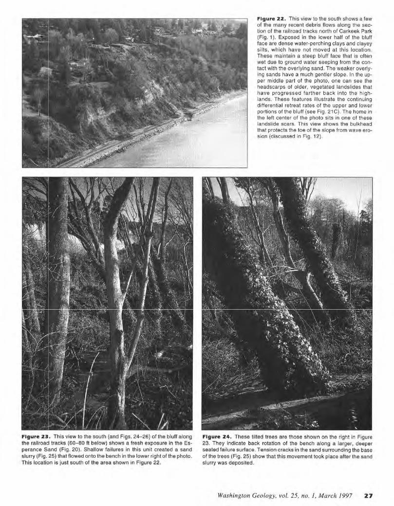
Figure 23. This view to the south (and Figs. 24-26) of the bluff along the railroacl tracks (60-80 ft below) shows a fresh exposure in the Esperance Sand (Fig. 20). Shallow failures in this unit created a sand slurry (Fig. 25) that flowed onto the bench in the lower right of the photo. This location is just south of the area shown in Figure 22.
Figure 22. This view to the south shows a few of the many recent debris flows along the section of the railroad tracks north of Carkeek Park (Fig. 1 ). Exposed in the lower half of the bluff face are dense water-perching clays and clayey silts, which have not moved at this location. These maintain a steep bluff face that is often wet due to ground water seeping from the contact with the overlying sand. The weaker overlying sands have a much gentler slope. In the upper middle part of the photo, one can see the headscarps of older, vegetated landslides that have progressed farther back into the highlands. These features il lustrate the continuing differential retreat rates of the upper and lower portions of the bluff (see Fig. 21 C). The home in the left center of the photo sits in one of these landslide scars . This view shows the bulkhead that protects the toe of the slope from wave erosion (discussed in Fig. 12).
Figure 24. These tilted trees are those shown on the right in Figure 23. They indicate back rotation of the bench along a larger, deeper seated failure surface. Tension cracks in the sand surrounding the base of the trees (Fig. 25) show that this movement took place after the sand slurry was deposited.
Washington Geology, vol. 25, no. I, March 1997 27
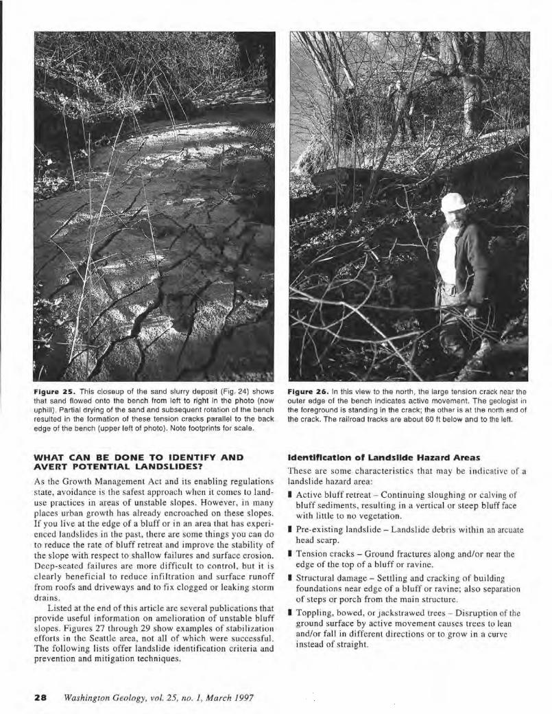
Figure 25. This closeup of the sand slurry deposit (Fig. 24) shows that sand flowed onto the bench from left to right in the photo (now uphill). Partial drying of the sand and subsequent rotation of the bench resulted in the formation of these tension cracks parallel to the back edge of the bench (upper left of photo). Note footprints for scale.
WHAT CAN BE DONE TO IDENTIFY AND AVERT POTENTIAL LANDSLIDES?
As the Growth Managemenl Act and its enabling regulations state, avoidance is the safest approach when it comes lo landuse practices in areas of unstable slopes. However, in many places urban growth has already encroached on these slopes. If you live at the edge of a bluff or in an area that has experienced landslides in the past, there are some things you can do to reduce the rate of bluff retreat and improve Lhe stability of the slope with respect to shallow failures and surface erosion. Deep-seated failures are more difficult to control , but it is clearly beneficial to reduce infiltrat ion and surface runoff from roofs and driveways and to fix clogged or leaking storm drains.
Listed at the end of this article are several publications that provide useful information on amelioration of unstable bluff slopes. Figures 27 through 29 show examples of stabilization efforts in the Seattle area, not all of which were successful. The fo llowing lists offer landslide identification criteria and prevention and mitigation techniques.
28 Washington Geology, vol. 25, no. 1, March 1997
Figure 26. In this view to the north, the large tension crack near the outer edge of the bench indicates active movement. The geologist in the foreground is standing in the crack; the other is at the north end of th e crack. The railroad tracks are about 60 ft below and to the left.
Identification of Landsllde Hazard Areas
These are some characteristics that may be indicative or a lands lide hazard area:
I Active bluff retreat - Continuing sloughing or calving of bluff sediments, resulting in a vertical or steep bluff face with little to no vegetation.
I Pre-existing landslide - Landslide debris within an arcuate head scarp.
I Tension cracks - Ground fractures along and/or near the edge of the top of a bluff or ravine.
I Structural damage - Settling and cracking of building foundations near edge of a bluff or ravine; also separation of steps or porch from the main structure.
I Toppling, bowed, or jackstrawed trees - Disruption of the ground surface by active movement causes trees lo lean and/or fall in different directions or to ·grow in a curve instead of straight.
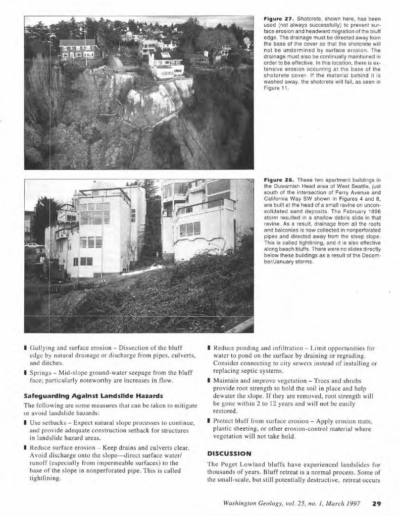
I Gu llying and surface eros ion - Di sseclion of Lhe bluff edge by natural dra inage or discharge from pipes, culverts , and ditches.
I Springs - Mid-s lope ground-water seepage from the bluff face ; particularly noteworthy are increases in flow .
Safeguarding Against Landslide Hazards
The fo ll owing are some measures that can be taken to mitigate or avo id lands lide hazards:
I Use setbat:ks - Expect natural s lope processes to continue, and provide adeq uate construction se tback for s tructures in landslide hazard areas.
I Reduce surface erosion - Keep drains and culverts c lear. Avoid discharge onto the slope- direct surface water/ runoff (especially from impermeable surfaces) to the base of the slope in nonperforated pipe. This is called tightlini ng.
Figure Z7. Shotcrete. shown here. has been used (not always successfully) to prevent surface erosion and headward migration of the bluff edge. The drainage must be directed away from the base of the cover so that the shotcrete will not be undermined by surface erosion. The drainage must also be continually maintained in order to be effective. In this location. there is extensive erosion occurring at the base of the shotcrete cover . If the material behind it is washed away, the shotcrete will fail, as seen in Figure 11 .
Figure ZS. These two apartment buildings in the Duwamish Head area of West Seattle , just south of the intersection of Ferry Avenue and California Way SW shown in Figures 4 and 8, are built at the head of a small ravine on unconsolidated sand deposits. The February 1996 storm resul ted in a shallow debris slide in that ravine. As a result, d rainage from all the roofs and balconies is now collected in nonperforated pipes and directed away from the steep slope. This is called tightlining , and it is also effective along beach bluffs. There were no slides di rectly below these buildings as a result of the December/January storms.
I Reduce ponding and infi ltration - Limit opportunities for water to pond on the surface by draining or regrading. Consider connecting to c ity sewers instead of instal ling or replacing septic systems.
I Maintain and improve vegetation - T rees and shrubs provide root strength to hold the soil in place and help dewater the slope. If they are removed, root s lrenglh will be gone with in 2 to 12 years and will not be eas ily restored.
I Protect bluff from surface erosion - Apply erosion mats, plastic sheeting, or other erosion-control material where vegetation wi ll not take hold.
DISCUSSION
The Puget Lowland bluffs have experienced landsl ides fo r thousands of years. Bluff retreat is a normal process. Some of the small-scale, but still potentially destructi ve, retreat occurs
Washington Geology, vol. 25, no. 1, March 1997 29
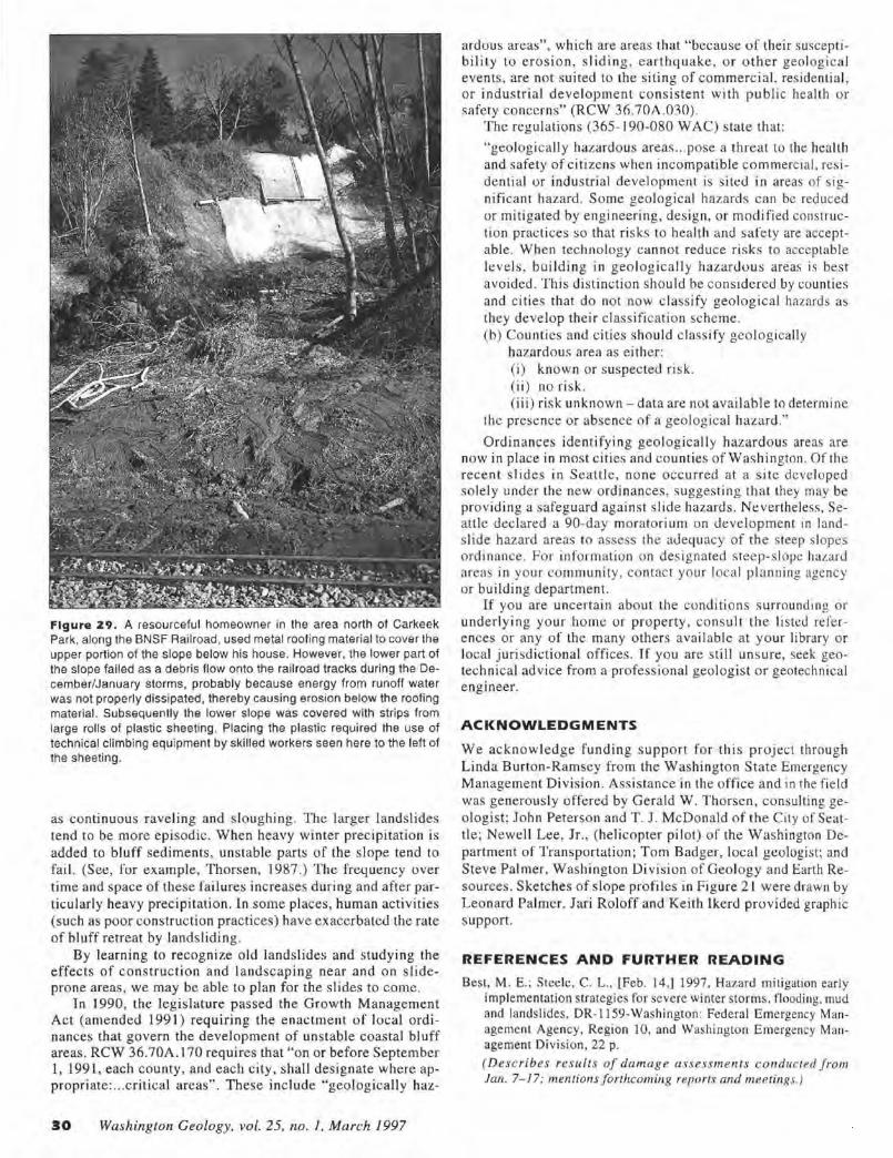
Figure 29. A resourceful homeowner in the area north of Carkeek Park, along the BNSF Railroad, used metal roofing material to cover the upper portion of the slope below his house. However, the lower part of the slope failed as a debris flow onto the railroad tracks during the December/January storms, probably because energy from runoff water was not properly dissipated, thereby causing erosion below the roofing material. Subsequently the lower slope was covered with strips from large rolls of plastic sheeting . Placing the plastic required the use of technical climbing equipment by skilled workers seen here to the left of the sheeting.
as continuous raveling and s loughing. The larger landslides tend to be more episodic. When heavy winter preci pitation is added to bluff sediments, uns table parts of the s lope tend to fail. (See, for example, Thorsen, 1987 .) The frequency over time and space of these fai lures increases during and after particularly heavy precipitation. In some places, human activities (such as poor cons truc tion practices) have exacerbated the rate of bluff retreat by landsliding.
By learning to recognize old landslides and studying the effects of construction and landscaping near and on s lideprone areas , we may be able to plan for the s lides to come.
1n 1990, the legislature passed the Growth Management Act (amended 199 l) requiring the e nactment of local ord inances that govern the development of unstable coastal bluff areas. RCW 36.70A. I 70 requires that "on or before September l, 1991, each county, and each city , shall designate where appropriate: ... critical areas" . These include "geologically haz-
30 Washington Geology, vol. 25, no. I , March 1997
ardous areas", which are areas that "because of their susceptibility to erosion , s liding , earthquake, or other geologica l events, are not suited to the s iting of commerc ial , residential, or industrial development consistent w ith public health or safety concerns" (RCW 36.70A.030).
The regulations (365- 190-080 WAC) s tate that:
"geologically hazardous areas ... pose a threat to the health and safety of citi zens when incompatible commercial, res idential or industrial development is si ted in areas of si gnificant hazard. Some geological hazards can be reduced or mitigated by engineering, design , or modified construction practices so that risks to health and safety are acceptable. When technology cannot reduce risks to acceptable levels , building in geological ly hazardous areas is best avo ided. This distinction should be considered by counties and cities that do not now classify geological hazards as they develop their c lassification scheme. (b) Counties and cities should classify geologically
hazardous area as either: (i) known or suspected risk. (ii) no risk. (iii) risk unknown - data are not avai lable to determine
the presence or absence of a geological hazard."'
Ordinances identifying geologically hazardo us areas are now in place in most ci ties and counties of Washington. Of the recent slides in Seattle, none occurred at a site developed so lely under the new ordinances, suggesting that they may be providing a safeguard against s lide hazards . Nevertheless, Seattle declared a 90-day moratorium on development in landslide hazard areas to assess the adequacy of the steep slopes o rdinance. For information o n designated steep-slope hazard areas in your community, contact your local planning agency or building department.
If you are uncertain abou t the conditions surrounding or under lying your home or property, consult the listed references or any of the many others availab le at your library or local jurisdictional offices. If you are still uns ure, seek geotechnical advice from a professional geologist or geotechnical engineer.
ACKNOWLEDGMENTS
We acknowledge funding support for this project through Linda Burton-Ramsey from the Washington State Emergency Management Division . Assistance in the office and in the field was generous ly offered by Gerald W . Thorsen, consulting geo logist; John Peterson and T. J. McDonald of the City of Seattle; Newell Lee, Jr., (helicopter pilot ) of the W ashington Department of Transportation ; Tom Badger, local geologist; and Steve Palmer, Washington Division of Geology and Earth Resources. Sketches of s lope profiles in Figure 2 1 were drawn by Leonard Palmer. Jari Roloff and Keith Ikerd provided graphic s upport.
REFERENCES AND FURTHER READING
Best, M. E. ; Steele, C. L., [Feb. 14,] 1997, Hazard mitigation early implementation strategies for severe winter storms, flooding. mud and landslides, DR-1159-Washington : Federal Emergency Management Agency, Region 10, and Washington Emergency Management Division, 22 p. (Describes results of damage assessments conducted from Jan. 7- 17: mentions forthcoming reports and meetings. )
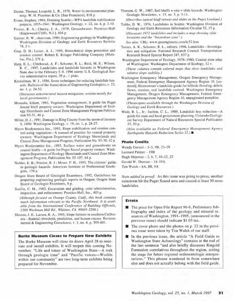
Dunne, Thomas; Leopold. L. 8 ., 1978, Water in environmental planning: W. H. Freeman & Co. !San Francisco], 818 p.
Evans , Stephen, 1994, Draining Seall le-WPA landslide stabilization projects, 1935-1941 : Washington Geology, v. 22, no. 4, p. 3-10.
Freeze, R . A .; Cherry, J. A. , 1979, Groundwater: Prentice-Hall [Englewood Cliffs. N.J .J, 604 p.
Galster, R. W., chairman, 1989, Engineering geology in Washi ngton: Washington Division of Geology and Earth Resources Bulletin 78, 2 V.
Gray, D. H.; Leiser. A. J. , 1989, Biotechnical slope protection and erosion control: Robert E. Krieger Publishing Company [Malabar, Fla.], 271 p.
Harp, E. L.; Chleborad, A. F. ; Schuster, R. L.; Reid, M. E.; Wilson, R. C., 1997, La ndslides and landslide hazards in Washington State due to the February 5- 9, 1996 storm: U.S. Geological Survey administrative report, 29 p., I plate.
Kockelman, W. J.. 1986, Some techniques for reduci ng landslide hazards : Bulletin of the Association of Engineering Geologists, v. 23, no. I , p. 24-52. ( Discusses nonstructural hazard mitigation; written mostly for local governments.)
Menashe, Elliott, 1993, Vegetation management; A guide fo r Puget Sound bluff properly owners: Washingto n Department of Ecology S horelands and Coastal Zone Management Program Publication 93-31 , 46 p.
Miller, D. J ., 1991 , Damage in Ki ng County from the storm of January 9. 1990: Washington Geology, v. 19, no. l , p. 28-37.
Myers Biodynamics Inc. , 1993 , Slope stabilization and erosion control using vegetation-A manual of practice for coastal property owners: Washingto n Department of Ecology Shorelands and Coastal Zone Management Program. Publication No. 93-30, 42 p.
Myers Biodynamics Inc., 1995, Surface waler and groundwater on coasta l bluffs- A guide for Pugel Sound property owners: Washington Department of Ecology Shorelands and Coastal Zone Management Program, Publication No. 95-107. 64 p.
Nuhfer, E. B.; Proctor, R. J .; Moser, P. H .. 1993, The citi1.ens ' guide to geologic hazards: American Institute of Professional Geologists, 134 p.
Oregon State Board of Geologist Examiners, 1992, Guidelines fo r preparing engineering geologic reports in Oregon: Oregon Stale Board of Geologist Examiners, 8 p.
Scullin, C. M., 1983 , Excavation and grading, code administration, inspection. and enforcement: Prentice-Hall. Inc., 403 p.
(Although focused on Orange County, Calif, this book contains much information relevant to the Pacific Northwest. It is available from the lnternarional Conference of Building Officials, 5360 Workman Mill Rd. , Whittier, CA 90601-2298.)
Slosson, J .E. ; Larson, R. A., 1995, Slope failures in southern California- Rainfall threshold, prediction , and human causes: Environmental & Engineering Geosciencc, v. l , no. 4, p. 393-40 I .
BurkEi Museum Closes to Prepare New Exhibits
The Burke Museum will c lose its doors April 28 to renovate and install exhibits. It will reopen this coming November. "Life and times of Was hington State-A trek th rough geologic time" and "Pacific voices-World s within our community" are two long-term exhibits being prepare d for November.
Thorsen, G. W., 1987, Soi l bluffs+ rain= slide hazards: Washi ngton Geologic Newsletter, v. 15, no. 3, p. 3-11.
( Describes typical bluff retreat and slides in the Puget Lowland.)
Tubbs, D. W., 1974, Landslides in Seattle: Washington Division of Geology and Earth Resources Information Circular 52, 15 p.
( Discusses 1972 landslides and includes a map showing slide locations and the "hazardous zone ".)
See also: URL: www.geoengineers.com/ic52.hlm
Turner, A. K.; Schuster, R. L ., editors, 1996, Landslides- Investigation and mitigation: National Research Council Transportation Research Board Special Report 247, 657 p.
Washington Department of Ecology, 1978-1980, Coastal zone atlas of Washington: Washington Department of Ecology, 12 v.
(These volumes contain colored maps thal show landslides and relative slope stabilily.)
Washington Emergency Management, Oregon Emergency Management, Federal Emergency Management Agency Region 10. [undated], Homeowner's landslide guide for hillside flooding, debris flows, erosion, and landslide control: Washington Emergency Management, Oregon Emergency Management, Federal Emergency Management Agency Region I 0, unpaginated pamphlet.
( Photocopies available through the Washing/on Division of Geology and Earth Resources.)
Wold, R. L., Jr.; Jochim. C. L. , 1989, Landslide loss reduction-A guide for state and local government p lanning: Colorado Geological Survey Department of Natural Resources Specia l Publication 33. 50 p.
(Also available as Federal Emergency Management Agency Earthquake Hazards Reduction Series 52. ) •
Photo Credits
Wendy Gerstel - 3-5, 98 , 23-29
Leonard Palmer - 198
Hugh Shipman - 2, 6. 7. I 0-12, 22
Gerald W. Thorsen - 14-19 A
Tim Walsh - SA, 88 , 9A
Note added in proof As thi s issue was going to press, another rainstorm h it the Puget Sound area and caused a t least 30 more
lands! ides.
Errata
• The price for Open File Report 96-6, Prel iminary bibliography and index of the geology and mineral resources of W ashington , 1991-1995, (announced in the previous issue) should indicate$ l .03 tax.
• T he cover photo and the photos on p. 22 in the previ ous issue were taken by Tim Walsh of o ur staff.
• In the previous issue, the artic le "A F ield Guide to Washington State Achaeology" contains a t the end of the last sentence "and also briefly discusses Ringold Formation correlatives throughout the region , setting the s tage for future regional sedimentologic interpretations." Thi s phrase wandered in from somewhere e lse and does not actually belong with the field guide.
Washington Geology, vol. 25, no. 1, March 1997 31
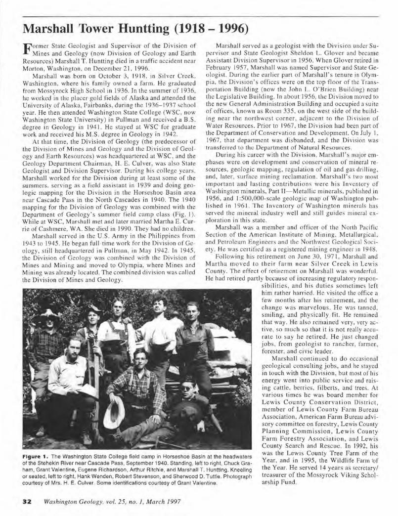
Marshall Tower Huntting (1918 - 1996) F ormer State Geologist and Supervisor of the Divis ion of
Mines and Geology (no w Division of Geology and Earth Resources) Marshall T. Huntting died in a traffic accident near Morton, W as hington, on December 2 1, 1996.
Marshall was born o n October 3, 1918 , in Si lver C reek, Washingto n. where hi s family owned a farm. He graduated from Mossyroc k High School in 1936. In the summer of 1936, he worked in the pl acer gold fields of Alaska and attended the University of Alaska, Fairbanks, during the 1936-1937 school year. He the n attended Washington State College (WSC , now Washington State University) in Pullman and received a B .S . degree in Geology in 1941. He stayed at WSC for graduate work and received hi s M .S. degree in Geology in 1942.
At that time, the Di visio n of Geology (the predecessor of the Division of Mines and Geology and the D iv ision of Geology and Earth Resources) was headquartered at WSC. and the Geology Department Chairman, H. E. Culver, was also State Geologist and Division Supervisor. During hi s co llege years , M ars hall worked for the Division during at least some of the summers, servi ng as a fie ld assistant in 1939 and doing geologic mapping fo r the Division in the Horseshoe Basi n area near Cascade Pass in the North Cascades in I 940. The 1940 mapping for the Divis ion of Geology was combined w ith the Department of Geology's s ummer field camp class (F ig. I ). While at WSC, Marsha ll met and later married Martha E. C urrie of Cashmere, WA. She died in 1990. They had no children .
Marshall served in the U.S. Army in the Philippines from 1943 to 1945. He began full -time work for the Division of Geology, still headquartered in Pullman, in M ay 1942. In 1945, the Di vision of Geology was combined with the Di vis io n of Mines and Mining and moved to Olympia, where Mines and Mining was already located . The combined division was called the Di vision of M ines and Geology.
Marshall ser ved as a geologist with the Division under Supervisor and State Geologist Sheldo n L. G lover and became Assistant Di vision Superviso r in 1956. When Glover retired in February 1957, Marshall was named Supervisor and State Geologis t. During the earl ier part of Marshall's tenure in Olympia, the Division's offices were o n the top floor of the Transportation Building (now the John L. O ' Brien Building) near the Legislative Building . Tn abou t 1956, the Divisi on moved to the new General Adminis tratio n Building and occupied a suite of offices, known as Room 335 , o n the west s ide of the building near the northwest corner, adjacent to the Divis ion or Water Resources . Prior to 1967, the Division had been part of the Department of Conservation and Development. On July I, 1967, that department was disbanded, and the Di vision was transferred to the Department of Natural Resources.
During hi s career with the Divis ion, Marshall's major emphases were on development a nd conservation of mineral resources, geolog ic mappi ng, regulatio n of oi l and gas drilli ng, and , later, su rface mining reclamation. Marshal l's two most impo rtant a nd lasting contributi ons were his Inventory of Washington minera ls, Part TT- Metallic minerals , published in 1956, and I :500,000-scale geo logic map o f Washington published in 1961. The In ventory of Washingto n minerals has se rved the mineral industry we ll and still g uides mineral exploration in this state.
Mars hall was a member and office r of the North Pacific Section of the American Ins t itute of Mining, Metallurgical. and Petroleum Engineers and the Northwest Geological Society. He was certified as a registered mining engineer in 1948.
Following h is retirement on June 30, 1971 , Marshall and Martha moved to th ei r farm near Silver Creek in Lewis County. The effect of retirement on M arsha ll was wonderful. He had retired partly because o f increasi ng regulatory respon
s ibilities, and hi s d uties sometimes left him rather harried. He visi ted the office a few months after hi s retirement, and the change was marvelous. He was tanned , smiling, and physically fi t. H e remai ned that way . He a lso remai ned very, very active, so much so that it is not really accurate to say he re tired. H e j ust changed jobs , from geologist to ra nc her, farmer , foreste r, and c ivic leader.
Figure 1. The Washington State College field camp in Horseshoe Basin at the headwaters of the Stehekin River near Cascade Pass, September 1940. Standing, left to right, Chuck Graham, Grant Valentine, Eugene Richardson. Arthur Ritchie , and Marshall T. Huntting. Kneeling or seated, left to right, Hank Wenden, Robert Stevenson, and Sherwood D. Tuttle . Photograph courtesy of Mrs. H. E. Culver. Some identifications courtesy of Grant Valentine.
Marshall con tinued to do occasiona l geolog ical consulting jobs, and he stayed in to uch with the Division, but most of his e nergy went into public service and raising cattl e, berries , fi lberts, and trees . At various times he was board member for Lewi s County Conservation Di s tric t, member of Lew is County Farm Bureau Association, American Farm Bureau advisory com mittee on forestry, L ewis County P la nning Commission, Lewis Cou nt y Farm Forestry Assoc ia ti o n , and Lew is County Search and Resc ue. In 1992, his was the Lewis County Tree Farm of the Year, and in 1995, the Wildli fe Parm ·of the Year. He served 14 years as secretary/ treasurer of the Mossyrock Viking Scholarship F und.
32 Washington Geology. vol. 25, no. 1, March 1997
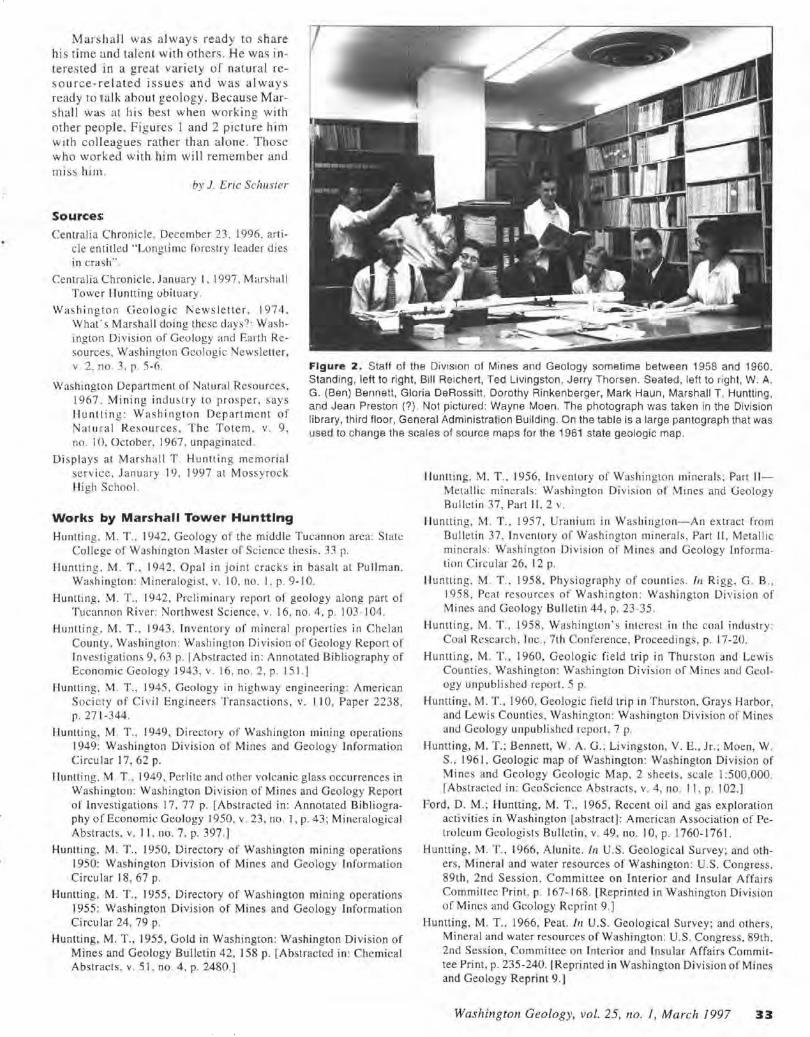
Marshall was always ready to share his time and talent with others. He was interested in a great variety o f natural reso urce-re lated issues and was always ready to ta lk about geology. Because Marshall was at his best when working with other people. Figures I and 2 picture him with colleagues rather than alone. Those who worked with him will remember and miss him.
by J. Eric Schuster
Source5,
Centralia Chronicle. December 23. 1996, article entitled ·'Longtime forestry leader dies in crash" .
Centralia Chronicle. January I. 1997. Mar~hall Tower I luntting obituary .
Was hington Geologic Newsletter. 1974. What-s Marshall doing these days?: Washington Di vision of Geology and Earth Resources. Washington Geologic Newslener, v. 2. no. 3, p. 5-6.
Washing ton Department of Natural Resources, 1967 , Mining industry to prosper. says Huntling: Washington Department of Nat ur al Resources, The Totem . v. 9, no. I 0. October, 1967. unpagin ared.
Figure 2 . Staff of the Division of Mines and Geology sometime between 1958 and 1960. Standing, left to right, Bill Reichert, Ted Livingston, Jerry Thorsen. Seated, left to right, W. A. G. (Ben) Bennett, Gloria DeRossitt, Dorothy Rinkenberger, Mark Haun, Marshall T. Huntting, and Jean Preston (?). Not pictured: Wayne Moen. The photograph was taken in the Division library, third floor, General Administration Building. On the table is a large pantograph that was used to change the scales of source maps for the 1961 state geologic map.
Displays at Marshall T . Huntti ng memo rial serv ice, J anuary 19 , 1997 at Mossyrock Hi gh School.
Works by Marshall Tower Hunttlng
Hunlling. M. T. , 1942. Geology of the middle Tuca nnon area : State College of Washington Master of Sc.:icncc thes is. :n p.
lluntti ng. M. T ., 1942. Opal in joint cracks in basalt at Pullman. Washington : Mineralogist. v. 10, no. I , p. 9-10.
Huntting. M. T ., 1942, Preli minary report of geology along part of Tucannon River: i'Jorthwest Science , v. 16, no. 4. p. I 03 - 104.
Huntting. M. T., 1943. Inventory of mineral properties in Chelan County, Washington : Washington Division of Geology Report of Inves ti gati ons 9, 63 p. I Abstracted in: Annotated Bibliography of Economic Geology 1943, v. 16, no. 2, p . 151.]
Huntting. YI . T. , 1945, Geology in highway engineering: American Socic:ty of Civil Engineers Transactions, v. 110, Paper 2238, p. 271-344.
lluntting. M. T .. 1949, Directory of Wash ington mining operations 1949: Washington Division of Mines and Geology Information Circular 17, 62 p.
1 luntting. M . T., 1949, Perlite and other volcanic glass occurrences in Washington: Washington Division of Mines and Geology Report of Investigations 17. 77 p. [Abstracted in: Annotated Bibliography of Economic Geology 1950, v. 23, no. I, p. 43; Mi ncralogical Abstracts, v. 11 , no. 7. p . 397.]
Huntting, M. T .. 1950, Directory of Washington mining operations 1950: Washington Division of Mines and Geology Information Circu lar 18, 67 p.
Huntting, M. T. , 1955, Directory of Washington mining operati ons 1955: Washington Division of Mines and Geology In formation Circu lar 24, 79 p.
Huntting, M. T ., 1955, Gold in Washington: Washington Division of Mines and Geology Bulle tin 42, 158 p. [Abstracted in: Chemical Abstracts, v. 51 , no. 4, p. 2480.]
Huntting, M. T.. 1956. In ventory of Was hington mineral s; Part II Metal lic minerals : Washington Division of Mines and Geology Bulletin 37, Part II. 2 v.
lluntting. M. T., 1957, Uranium in Was hington-An extract from Bulletin 37. Inventory of Washington minerals, Part II , Metallic minerals: Washington Division of Mines and Geology Information C ircular 26, 12 p.
ll untting. M. T ., 1958. Physiography of counties. In R igg, G . B. , 1958, Peat resources of Washington : Washington Division o f Mines and Geo logy Bulletin 44, p. 23-35.
Huntting, M. T.. 1958, Wash ington 's interest i11 the coa l industry: Coal Research. Tnc., 7th Conference, Proceedings, p. 17-20.
Huntting, M. T ., 1960, Geologic field trip in Thurston and Lewis Counties. Washington: Was hington Di vision of Mines and Geology unpublished report. 5 p.
Huntting, M. T. , 1960, Geologic field trip in Thurston, Grays Harbor. and Lewis Counties, Washington: Washington Division of Mines and Geology unpubli shed report. 7 p.
Huntting, M. T.; Bennett, W . A.G.; Livingston, V. E., Jr. ; Moen, W . S .. 196 I , Geologic map of Washington : Washi ngton Division of Mines and Geology Geologic Map. 2 sheets. scale 1 :500,000. [Abstracted in: Geo Science Abstracts, v. 4, no. I 1. p . 102.]
Ford, D. M.; Huntting, M. T., 1965, Recent oil and gas exploration activities in Washington [abstract]: American Association of Petroleum Geologists Bulletin , v. 49, no. I 0 , p. 1760-1761 .
Huntting, M . T. , 1966, Alunite. In U.S. Geologica l Survey; and others, Mineral and warer resources of Washington : U.S. Congress. 89th , 2nd Session, Committee on Interior and Insu lar Affairs Committee Print , p. 167-168. [Reprinted in Washington Divi sion of Mines and Geology Reprint 9.)
Huntting, M. T., 1966. Peat. /I! U.S. Geological Survey; and others, Mineral and water resources of Washington: U.S. Congress, 89th, 2nd Session, Committee on Interior and In su la r Affairs Committee Print, p. 235-240. I Reprinted in Washington Division of Mines and Geology Reprint 9 .]
Washington Geology, vol. 25, 110. / , March 1997 33
Huntting, M. T., I 966, Pumice, pumicite, volcanic cinders, and perlite. In U.S. Geological Survey; and others, Mineral and water resources of Washington: U.S . Congress , 89th, 2nd Session, Committee on Interior and Insular Affairs Committee Print, p. 240-245. [Reprinted in Washington Division of Mines and Geology Reprint 9. ]
Huntting, M. T., 1966, Washington mineral deposits: Washington Division of Mines and Geology Reprint 10, 7 p.
Huntting , M. T., 1966, Washington mineral deposits. /11 Canadian In stitute of Mining and Metallurgy; and others, A symposium on the tectonic history and mineral deposits of the western Cordillera in British Columbia and neighbouring parts of the Un ited States, Va ncouver [BC], 1964: Canadian Insti tute of Mining and Metallurgy Special Volume 8, p. 209-214.
Hu ntting, M. T., 1968, Mineral resources in Washington forest land management: Washington Stale Forestry Conference, 47th Annual, Proceedings, p. 49-54.
Huntti ng, M. T. , 1971 , The Washington State Geologists: Journal of the West, v. 10, nu. I , p. 158- 162.
Moen. W . S. ; Huntting, M. T. , 1975, Handbook for gold prospectors in Washington: Washington Division of Geology and Earth Resources In fo rmation Circular 57, 90 p. [Reprinted 1983.]
Schuster. J. E.; Blackwell , D. D.; Hammond, P. E. ; Huntting, M. T., 1976, Heat-flow studies in the Steamboat Mountain-Lemei Rock area , Skamania County, Washington [abstract]: American Association of Petroleum Geologists Bulletin, v. 60, no. 8, p. 1410.
Schuster, J. E.; Blackwell, D. D. ; Hammond, P. E.; Huntting, M. T., 1978, Heal flow studies in the Steamhoat Mountain-Lemei Rock area, Skamania County , Washington: Washington Division of Geo logy and Earth Resources Information Circular 62, 56 p.
Moen, W . S. ; Huntting, M. T .. 1979, Gold in Washing ton: Washington Geologic Newsletter. v. 7 , no. 4 , p. 1-6. •
Charles Phillips Purdy, Jr. (1916-1997)
Phil Purd y, geologist with the Was hing to n Divis io n o f Mines and Geology for several years , died in Spokane on
February 24, 1997, at age 81. During his career as a mining geo logis t he worked for both federal and state governments and for several corporations in the western United States, Canada, Greenland , and Central America. He retired in 1985 , settled in Spokane, and became acti ve with the Mineral Information Institute.
He began working for the Divis io n as a geologist on April 7, 1947, and resigned on October 15 , 1954. T he 1948- 1950 biennial report of the Division of Mines a nd Geology (Glover, 1951 ) lists Purdy ' s education as S .B. in Geology, Harvard College, and postgraduate in mining geology, Massachusetts lnstitute o f Techno logy. He was the author of several reports for the Divis ion , li sted below.
Division Publlcatlons
Purdy, C. P .. Jr. , 1951. Antimony occurrences of Washington: Washington Division of Mines and Geology Bulletin 39. 186 p.
Purdy, C. P., Jr. , 1952, Directory of Washington mining operations: Washington Division of Mines and Geology In formation Circular 20. 75 p.
NORTHWEST PALEONTOLOGICAL SOCIETY
I May 3 meeting at the Burke Museum: Showcase session for members' collections
I June: Trip being planned to Chuckanut Formation outcrops; Bill Smith, leader
I August: Trip to Olequah and Coal C reeks, Cowlitz Formation; Bill Smith, le ader
For more information about these field trips, contact Bi II Smith, 13332 Ridgeland Dr. , Silverdale, WA 98383.
Membership is $15/yr, $25 for families, $10 stude nt or senior, and $5 junior; send checks to Betty Jarosz, 17807 NE I 02nd Ct., Redmond, WA 98073. (Although elections are s lated for May, questions and applications will be forwarded to the appropriate officers.)
34 Washington Geology, vo l. 25, no. 1, March 1997
Purdy, C. P., Jr., 1953, Directory of Washington mining operations : Washington Division of Mines and Geology Information Circular 21, 81 p.
Purdy , C. P., Jr. , 1954, Di rectory of Was hington mining operations: Washington Divis ion of Mines and Geology In fo rmation circu lar 23 , 73 p.
Purdy, C. P. , Jr., 1954, Molybdenum occurrences of Washington: Washington Division of Mines and Geology Report of Investigations 18. 11 8 p .. 13 pl.
References
Charles Purdy Jr. obituary, The Spokesman-Review, Spokane, WA, February 28, 1997, p. B2.
Glover, S. L. , 1951 , Biennial report no. 3 of the Division of Mines and Geology, for the period commencing October I. 1948 and ending September 30, 1950: Washington Division of Mines and Geology, 13 p.
Glover, S. L. , 1956, Biennial report no. 6 of the Division of Mines and Geology, for the period commencing July I , 1954 and ending June 30. 1956: Washington Division of Mines and Geology. 12 p. •
NORTHWEST GEOLOGICAL SOCIETY
At the April 8 meeting, John Delaney will discuss exploration of the Juan de F uca Ridge. On May 13, Darrel C o wan will talk about the San Juan Islands, a prelude to the members-onl y field trip he will lead June 6- 8. The Division of Geology and Earth Resources plans to bring to each meeting copies of important new publications, ne w Division releases, and papers related to the speaker's subject. These would be "for inspection only" as an e ffort to inform members of what is avail able.
Meetings are held at the University Plaza H o tel , just west of 1-5 on 45th Ave. Anyo ne may attend these meetings.
Tom Bush is president of the society, Dav id Knoblach is pres ide nt-e lect, Linda Schieber is Treasurer, M att Mero is Director of Publications, and John Whitmer serves as editor. B oard members are Emery Bayley, Brian Lowes , and Art Coulter. For membership information, write to Donn Charnley (NWGS Secretary), 19344 11 th Ave NW , Seattle, WA 98177-2613. Dues a re $20 a year, $5 fo r students.
Book Review: Geological History of the Wenatchee Valley The Geological History of the Wenatchee Valley
and Adjacent Vicinity, A Pictorial Essay by Charles L. Mason. Price $29.95 .
Pixie Publishing ( 1996). 172 p. Softcover.
Available from the author at Pixie Publishing, P.O. Box 97, Rock Island, WA 98850-0097
The author presents the geologic history of the Wenatchee area, with Wenatchee as the geographic center of the dis
cussion, and describes geologic events more or less chronologically. His presentation is that of an advanced amateur, with corlege courses and much practical experience, but no four-yeair degree in geology. Chapter headings are: ln the beginning; The formation of Washington State; The rock cycle; Igneous rnck structures ; Basalt flows of the Columbia Plateau; Volcanoes and earthquakes ; Consolidated and unconsolidated sedimentary deposits ; Metamorphic structures; Landslides; Bretz-Missoula floods; Moses Coulee; Erratics , Knapp and Navarre Coulees; Malaga slide; Metallic, industrial and carbonaceous activity in the Wenatchee area; and Conclusion.
The book has a number of strengths. Although the geologic events d,c:scribed center on Wenatchee, many are treated in a regional , statewide, or even larger context, so the book is meaningful to people living outside the Wenatchee area. There is enough informal cross-refere ncing in the text to tie concepts, localities , and geologic events together adequately. The author displays an obvious wide-ranging interest in geology, has read the geologic literature treating the Wenatchee area, understands the geologic concepts and interpretations of geologists who have published on the geology of the area, has observed! the geology of the area extensively , and presents the information in an easy-to-read way. His discussion is quite broad ranging-he has attempted to cover the whole of the geologic history of the Wenatchee area, not just selected geologic events. Basic concepts needed to understand his discussion are explained, so the book can be read by a layperson without reference to other \.VOrks.
The author adds historical sketches that tie the geology to human activities . He explains the significance of past geologic events such as earthquakes and volcanic eruptions and discusses potential dangers from future events. Most of the locations are described and located well enough so the reader could find them with the aid of good maps and a knowledge of the section, township, and range location system.
Mason does quite a nice job of describing the sedimentary units in the Wenatchee area- the Swauk, Chumstick, and Wenatchee Formations. He covers the various aspects of the Columbia River basalts nicely and at considerable length. His best trealtment, perhaps, is of the events of the last glaciation, especially the glacial Lake Missoula outburst floods and how they and related events shaped the topography and unconsolidated deposits found in the Wenatchee area today.
I think the most impress ive feature of the book is the 198 color photographs, all taken by the author and his wife. Most illustrate the chosen feature well and have reproduced well.
The book also has a number of weaknesses . These include random capitalization, frequent misspellings, choice of wrong homonyms (roll for role, brakes for breaks, vain for vein, sheer for shear, mixed usage of terrain and terrane), careless and inconsistent use of the names of geologic units, lack of
location maps , and use of "strata" and "stratum" without regard to the number of strata being discussed. Mason uses the term "structure" as a catchall term that includes, in different places, folds, faults, outcrops, peperite, hyaloclastite, hills, and igneous intrusions. This is quite irritating to a geologist who is accustomed to the word having a specific and much narrower meaning.
The author simplifies the plate tectonic history of Washington to only three accretionary packages, which he calls the Okanogan micro-island continent, Cascade micro- island continent , and Crescent terrane. For the non-geologist reader, this simplification is probably acceptable, even desirable.
There are a few outright mistakes and garbled definitions, for example, from page 58, "The oldest sedimentary formation within our state may be the Swauk."; from page 18, "An unconsolidated sedimentary material is rather self explanatory. The sediment i.s loose and 'unstratified."'; and, from page 131, "An erratic is defined as a 'rock' of indeterminable size, transported by ice, from its 'in stiu ' [sic] position, to some other indiscriminate location."
Overall. the book is a worthwhile effort and has much to offer both amateur and professional geologists. It would have been an outstanding book if the manuscript had been reviewed by a geologist and if misspellings, wrong homonyms, and English usage had been corrected .
New Book on the Paleontology of British Columbla
by J. F,ric Schuster
"Life in Stone", a book about the paleontology. fossils. and fossil collectors of British Columbia has just been printed by the University of British Columbia Press. Rolf Ludvigsen has compiled and edited the contributions of numerous scientists and produced a comprehensive introduction to ancient life in our neighboring province. If not available locally, it can be ordered from Duthie Books, 919 Robson St., Vancouver, BC V6Z IA5; (604) 684-4496. The price is about $65 .00 Canadian or $45.50 U.S.
Ginkgo Petrified Forest Museum Ginkgo Petrified Forest Museum in Vantage 1997 hours are 10 am- 6 pm, weekends only in April; Friday- Sunday, May L-12 ; and Thursday-Monday, May 16- Labor Day, when the schedule is reduced to Friday- Sunday. Groups tours (for a fee) of the facility are available year-round and can be arranged by calling (509) 856-2700. New events this year:
• The museum will be showing and selling the video "The Great Floods", depicting the Pleistocene outburst floods from glacial Lake Missoula.
• Ecology class: Wild Plants of the Desert, a 4-hr seminar describing native plants and their uses. By appointment, 12 person minimum, $3 per person. Led by Debbie Hall. Begins in April , wee kdays only; schools will get reduced rates. Reserve time by calling the museum.
• Ginkgo seedlings will be sold to raise fund for the museum.
Washington Geology, vol. 25, no. I. March 1997 35
Selected Additions to the Library of the Division of Geology and Earth Resources November 1 996 through February 1 997
THESES
Ahrens, R. J ., 1995, Pedogenes is in soil s derived from the tephras of Mount St. Helens : University of Nebraska Doctor of Philosophy thesis, 233 p.
Aziz, N. M., 1995. A baseline waler quantity investigation of th e west Medical Lake drainage bas in, Spokane County, W as hington : Eastern Washington University Master of Sc ience thesis, 90 p.
Boese, R. M., 1996, Aqui fer delineation and baseline groundwater quality in vestigation of a portion of north Spokane County. Washington: Eastern Washington Univers ity Master of Science thesis, 224 p.
Gough, Stan , 1995, Description and interpretation o f late Quaternary sediments in the Rocky Reach of the Columbia River va lley, Douglas County, Washington: Eastern Washington Un ive rs ity Master of Science thesis, 11 2 p., 3 plates.
Johnson , E. A., 1995, Soil-gas radon mapping and seasonal variability, Spokane area, Wash ington: Eastern Washington University Master of Science thesis , l 01 p.
May, M. T. , 199 1, Reanalysi s of COCORP seismic reflection data from the Priest River metamorphic core complex of northeastern Washi ngton: Uni versi ty of Wyoming Master of Science thesis, 89 p.
Morri s, G. A., 1996. Petrogenesis of calc-alkaline rocks in an extensional environment- The Eocene Co lvi lle batholith of northeast Washington. USA: Washington State University Doctor of Phi losophy thesis, I 39 p.
Olson , D. F., 1995, Geology and geochemistry of the Lock wood vol canogenic massive sulfide deposit, Snohomish County, Washington: Western Washi ngton University Master of Science thesis, I 18 p. , 8 plates .
Tucker, A. 8. , 1995 , A systematic evaluation of fossil Rani nidae from the Twin River Group, Olympic Penin sula , Washington, and a reexamination of the Raninidae : Kent Stale University Doctor of Phi loso phy thesis, 2 v.
Zheng, Yi , 1995, Distribution of major and trace me tals in groundwater of the Spokane aquifer, northeastern Washington- Water quality and river/aquifer interaction: Eastern Washington University Master of Science thesis, 123 p.
U.S. GEOLOGICAL SURVEY
Published reports
Rogers, A . M. ; Walsh, T . J .; Kockelman. W . J .; Priest, G . R., editors, I 996, Assessing earthquake hazards and reducing risk in the Paci fi c Northwest: U .S. Geological Survey Professional Paper 1560, 306 p., 5 plates .
Includes:
Adams, John, Great earthquakes recorded by turbidites off the Oregon-Washi ng ton coast. p. 147-158.
Atwater, B. F ., I 996, Coastal evidence for great earthquakes in western Washington . p. 77-90.
Goldfinger, Chris; Kulm, L. D.; Yeats, R. S.; Appelgate, T. B., Jr. ; --MacKay, M. E.; Cochrane, G. R. , Active strike-slip faulting
and foldi ng of the Cascadia subduction zone plate boundary and forearc in central and northern Oregon. p . 223-256.
36 Washington Geology, vol. 25, no. 1, March 1997
Ma. Li ; Crosson , R. S.: Ludwin, R. S., Western Washington earthquake focal mechanisms and their re lat ionship to regional tectonic stress. p. 257-283.
Ne lson, A. R. ; Pe rsonius. S. F .. Great-earthquake potential in Oregon and Washingto n- An overview of recent coastal geologic studi es and thei r bearing on scgmenl ati on of Holocene ruptures, central Cascadia subducti on zone. p. lJ 1-114.
Peterson, C. D. ; Darienzo , M. E .. Discrimination of climatic, oce anic, and tectonic mechanis ms of cycl ic marsh burial. p. I 15-146.
Rogers. A. M .; Wa lsh, T. J. ; Kockelman. W . J.; Priest, G. R .. Earthquake hazards in the Paci fie Northwest-An overview. p. 1-54.
Rogers, A . M.; Wa lsh, T . J .; Kockelman, W. J.; Priest, G. R., Map showing known or suspected faults with Quaternary displacement in the Pacific Northwest. Pl ate I , scale 1 :2,000,000.
Snavely, P. D., Jr ; Wells, R. E., Cenozoic evolution of the continental margin of Oregon and Wash ington. p. 16 1-1 82.
Walsh, T. J., An in troduction to earthquake sources of the Pacific Northwest. p. 7 I-74.
Weaver. C. S.; Shedlock, K. M .. Estimates o f seismic sourcc regions from the earthquake distri bution and regional tec1onics in the Pacific Nonhwcst. p. 285-306.
Yeats , R. S. ; Graven, E. P.; Go ld finger. Ch ri s. Map showing s truct ure contou rs on top of bedrock. Benton. Lane, Linn, Marion, and Polk Counties, Oregon. Plate 3, scale I: I 00,000.
Yeats, R. S.; Graven , E. P.; Werner, K. S.; G oldfinger. Chris ; Popowski, T. A .. Cross sections and se lected res idual gravity anomaly profiles of the Wil lamette Valley, Oregon. Plate 2C.
Yea ts, R. S.; Graven, E. P. ; Werner. K. S. ; Goldfinger, Chris; Popowski, T . A. , Geologic map of the centra l and southern Willame tte Va lley, Ben ton, Lane, Linn , Marion, and Polk Cou nti es, Oregon. Plate 28 , scale I : 100,000.
Yeats, R. S. ; Graven, E. P .; Werner, K . S.; Goldfinger. Chris ; Popowski, T. A., Tectonics of the Willame tte V alley, Oregon. p. 183-222.
Yeats, R. S.; Werner, K. S.; Popowski, T . A., Geologic map of the northern Willamette Valley, Clackamas , Marion, Mu llnomah , Polk, Tillamook, Washington, and Yamhill Counties, Oregon. Plate 2A, sc ale I: 100,000.
Miller, F. K .. I 996. Geo logic map of the Addy area, Stevens County, Washin gton : U.S. Geological Survey Miscellaneous Investigations Series Map 1-2492, I sheet . scale I :48 ,000.
Miller, F. K. , 1996, Geo logic ma p of the Empe y M ountain area, Stevens County, Washington : U.S. Geological Survey Miscellaneous Investigations Series M ap 1-2493, I sheet, scale I :48,000.
Murphy, Christine; Briggs, Paul ; Ad rian Betty; and others, 1997, Chain of custody- Recommendations for acceptance and analysis of evidentiary geochemical samples: U.S. Geological Survey Circular 1138, 26 p.
Spudich, Paul, editor, 1996, The Loma Prieta, California, earthquake of October 17, 1989- Main-shock characteristics: Li .S. Geologi cal Survey Professional Paper 1550-A, 297 p.
U.S. Geological Survey, 1996. Understanding the earth-Yearbook, fisca l year 1995: U.S. Geological Survey, 1106 p.
Includes:
Driedger, C. L., " What to do with a volcano in your backyard"'- Volcano hazards outreach at Mount Rai nier. p. 67-68.
Helsel, Dennis; Williamson. A. K.; Ryker, S. J., Pesticides in public supply wells of Washington State. p. 36.
Wiggins, W . D. ; Ruppert, G. P.; Smith, R.R.; Reed. L. L.; Hubbard , L. E.; Courts, M. L., 1996, Water resources data, Washi ngton water year 1995: U.S. Geologica l Survey Water-Data Report WA -95- 1, 456 p.
Open-Fllle and Water-Resources Investigations Reports
Berenbroc:k, Charles; Bassick, M. D.; Rogers , T . L. ; Garcia, S. P., 1995, Depth to water, 1991 , in the Rathdrum Prairie. Idaho: Spokane River valley, Washi ngton; Moscow-Lewiston-Grangeville area. Idaho ; and selected intermontane valleys , east central Idaho: U.S. Geological Survey Water-Resources Investigations Report 94-4087. 2 sheets.
Bookstrom, A. A.; Zientek , M. L. ; Box, S. E.; Derkey, P. D.; Elliott, J. E.; Frishman. David: Ashley, R. P. ; Evans, R. C.: Stoeser, D. B.; and others, 1996, Status and metal content of sign ificant metallic mineral deposits in the Pacific Northwest-A contribution to the Interior Columbia Basi n Ecosystem Management Project: U.S. Geologi ca l Survey Open-File Report 95-688, I v.
Embrey, S. S.; Block, E. K., 1995, Reconnaissance investigation of water quality , bottom sediment, and biota associated with irrigation drainage in the Columbia Basin Project, Washington, 1991-92: U.S. Geological Survey Water-Resources Investigations Report 95-4007, 144 p.
Finn. C. A .. 1996. Aeromagnetic map of the Longv iew area, southwest Washington and northwest Oregon: U.S. Geological Survey Open-File Report 96- 667, 4 p . !URL: http://geophysics .cr. usgs. gov/potenti al_ field/ longview _mag .htm I]
Fuhrer. G . J.: Cain , D. J. ; McKenzie, S. W.: Ri nella, J. F.; Crawford, 1. K.; Skach, K. A.; Hornberger, M. I. , 1996, Surface-water-qual ity assessment of the Yakima River Basin in Washington- Spatial and temporal distribu tion of trace elements in water, sediment, and aquatic biota, 1987-91 ; with a section on Geology , by M. W. Gannett : U.S . Geologica l Survey Open-Fi le Report 95-440, 190 p.
Includes: Gannet t, M. W ., Geologic overview. p. 10-11.
Glicken, Harry. 1996, Rockslide-debris avalanche of May 18, 1980, Mount St. Helens volcano, Washington: U .S. Geological Survey Open- File Report 96-677, 90 p., 7 plates.
Hansen, A. J ., Jr.; Vaccaro. J. J .; Bauer, H. H ., 1994, Ground-water now si mulation of the Columbia plateau regional aq uifer system, Washington , Oregon, and Idaho: U.S. Geological Survey WaterResources Investi gations Report 91 -4 187, 8 1 p., 15 plates.
Hinkle. S . R., 1996, Age of grou nd water in basalt aquifers near Spring Creek National Fish Hatchery , Skamania Co unty, Washington: U.S. Geo logical Survey Water-Resources Investigations Report 95-4272, 26 p.
Junes, M. A., 1996, De lineation of hydrogeolog ic uni ts in the lower Dungeness River Basin , Clallam County, Washington: U.S. Geologica l Survey Water-Resources In vestigations Report 95-4008, 11 p. , I plate.
Jones, M. A., 1996, Thickness of unconsolidated deposits in the Puget Sound lowland , Washington and British Colu mbia : U.S. Geological Sur vey W ater- Resources Investigations Report 94-4 133, I sheet.
Packard, F. A.; Hansen, A. J. , Jr. ; Bauer, H. H. , 1996, Hydrogeology and si mulation of flow and the effects of development alternatives
on the basalt aquifers of the Horse Heaven Hills, south-central Washington: U.S. Geological Survey Water-Resources Investigations Report 94-4068. 92 p., 2 plates.
Raines, G. L.; Johnson. B. R. ; Frost, T . P.; Zientek, M. L., 1996. Digita l maps of compositionally classified lithologies deri ved from l :500,000 scale geologic maps fo r the Pacific orthwes t- A contribution to the Interior Columbia River Basin Ecosystem Management Projcc l: U.S. Geologica l Survey Open-File Report 95-685. 29 p.
Ryder, J. L. , 1997, Active-, inactive-, and abandoned-mine in formation and selecled geochemical data for the Slate of Washington: U.S . Geological Survey Open-File Report 96-7 10, 8 p., I d isk.
Ryker, S. J.; Willi amson, A. K., 1996, Pesticides in publi c supply wells of Washington State: U.S. Geological Survey Fact Sheet FS-122-96, 2 p.
Swanson. D. A ., 1996. Geologic map of the Packwood Lake quadrangle, southern Cascade Range, Washington: U .S . Geological Survey Open-File Report 96-704, 25 p., 2 plates .
Tomlinson, S . A. , 1996. Comparison of Bowen-ratio, eddy-correlation, and weighing-lysimeter-evapotranspiration for two sparsecanopy sites in eastern Washington : U.S . Geo logical Survey Waler-Resources Investigations Report 96-4081 , 69 p.
Tomlinson, S. A., 1996, Evaluating evapotranspiration for si x sites in Benton. Spokane, and Yakima Counties. Washington: U.S . Geological Survey Waler-Resources Investigations Report 96-4002. 84 p.
Wagner, R. J. ; Ebbert, J.C. ; Roberts , L. M .; Ryker, S. J., 1996, Agricultural pesticide applications and observed concentrations in surface wate rs from four drain age basins in lhc cenlral Columbia plateau , Washington and Idaho, 1993-94: U.S. Geo logical Survey Water-Resources Investigations Report 95-4285. 52 p.
OTHER REPORTS ON WASHINGTON GEOLOGY
Amara, M. S. ; Neff, G. E., I 996, Geologic road trips in Grant County. Washington: Adam East Museum and Art Center [Moses Lake, Wash.] , 93 p.
Bergstrom, K. A.; Mitchell, T. H .. 1994. Geophysical survey fo r proposed 199-K- 108-A, 100- K area: Westinghouse Hanford Company WHC-SD-EN-Tl -228. 8 p.
Cascadia Region Earthquake Workgroup, l 996, "Cascadia stormsA dress rehearsal"; Proceedings from the I st annual meeting: Cascadia Region Earthquake Work.group, 72 p.
Dethier, D. P.; White. D. P.: Brookfie ld, C. M., 1996, Maps of the surficial geology and depth to bedrock of False Bay , Friday Harbor, Rich ardson, and Shaw Is land 7 .5-minute quadrang les, San Juan County , Washington: W ashington Divi sion o f Geology and Earth Resources Open Fi le Report 96-7, 7 p., 2 plates.
Farris , W . T . . 1994, User ' s gu ide fo r the atmos phe ric pa thway dosimetry report (PNWD-228 HEDR)- Hanford Environmen ta l Dose Reconstruction Project: Batte lie Paci fie Northwest Laboratori es PNWD-SA-4064 HEDR, 7 p.
Farris, W. T .: Napie r, 8. A .; Es linger, P. W. ; Ikenbe rry, T. A.; Shipler, D. B. ; S impson , J.C., 1994, Atmospheric pathway dos imetry report, 1944-1992: Battelle Pacific Northwest Laborato ries PNWD-2228 HEDR, I v.
Garrigues , R. S., 1996, Ground-water quality characterization and nilrate investigation of the G lade Creek watershed : Washington Department of Ecology Publication 96-348, I v.
Gilmore, B. G. ; Walters. W. H. , 1993, Water erosion field tests for Hanford protec tive barriers-FY 1992 s tatus report : Paci fi c Northwest Laboratory PNL-8949, l v.
Hathhorn, W. E.; Wubbena, T. R., 1994, Groundwater risk assessment score sheet for the Spokane Valley aquifer: WashingLOn Water Research Center Report A-18 1-WASH, 82 p.
Washington Geology, vol. 25, no. 1, March 1997 37
Hath horn , W. E.; Yonge, D. R. , 1996, The assessment of groundwater pollution potential resu lting from stormwater infiltration BMP's: Washi ngton State Transportation Center, 57 p.
Haugcrud, R. A. ; Mahoney, J . B .: Dragovich , J . D., 1996, Geology of the Methow block-A guide lo a 4-day excursion in the Mcthow valley, Okanogan County , Washington, focusing on the stratigraphy , internal structure and bounding faults of the Methow block. with comments on the evolution of the landscape: Northwest Geological Society, 3 7 p.
Hooper, P. R.; Gillespie, B. A. , 1996, Geologic map of the Pomeroy area, southeastern Washington: Washington Division of Geology and Earth Resources Open File Report 96-5. 26 p .. I p late.
Horowitz, A. J., 1995, The use of suspended sediment and associated trace e le ments in water quality studies: International Association of Hydrol ogical Sciences Special Publication 4. 58 p.
Huckell/Wei nman Associates, Inc., 1996, Cadman Black Diamond mine pit expansion , file no. L93RZ009- Final environmental impact statement : King County Department of Development and Environmenta l Studies, I v.
Koschmann, /\. H.; Bergendahl, M. H., 1968, repr. 1996?, Principal gold-produci ng di stri c ts of Washing ton: Carson Enterprises [De ming, N.M., reprinted from U .S. Geologica l Survey Professional Paper 61 OJ, 8 p.
Lindsey . K. A ., 1996, The Miocene to Pliocene Ringold Formation and associated deposits of the ancestral Columbia River system , south-centra l Washington and north -central Oregon: Washington Divi s ion of Geology and Earth Resources Open Fi Jc Report 96-8, I V ,
Lyatsky, H. V ., 1996, Continental-crust structures on the co ntine ntal margin of western North America: Springer-Verlag Lecture Notes in Earth Sciences 62. 352 p.
Marsh, M. L. ; Gianotti, C. M., 1994. Structural response to long-durat ion earthquakes: Washi ngton Department of Transportation . 40 p.
Mason, C . L. , 1996, The geological histo ry of the Wenatc hee valley an<l ai..ljacent vic inity , a pictorial essay : Pixie Publishing [Rock Island, Wash.], 172 p.
Powell, Lo rraine ; Powell , J. E., 1997, Ringold- White Bluffs lands lii..lt:s-Upuate ; Memorandum to Duane Unland , January 23, 1997: Washington Department of Natural Resources, I v.
Powell, Lorraine; Powell, J.E., 1996, Landsliding in the Ringo ld area: Memorandum to Duane Unland , November 20 , 1996: Washington Department o f Natural Resources, I v.
Reid. L. M.; Dunne , Thomas, 1996. Rapid evalua tion of sediment budgets: Catena Verlag GMBH, 164 p .
Stilson, M . L. ; Meatte, Dan; Whitlam, R. G., 1996. A field guide to Washington State archaeology: Washi ngton Department o f Natura l Resources, I v.
Stonerose Interpretive Center, 1996, Geology, paleontology, and mining history of Republic, Washington: Stonerose Interpretive Center; Ferry County Hi storical Society, 44 p. (Note: This is a reprint of Washing ton Geology, v. 24, no. 2).
U.S. Forest Service, 1996, Status of the interior Columbia BasinSummary of scientific findings: U.S . Forest Se rvice, 144 p.
University of Washington Geophysics Program. l 996, Quarterly network report 96-C on seismicity of Washington and Oregon, July I through September 30, 1996: University of W ashington Geophysics Program, 31 p.
University of Washington Geophysics Program, 1997, Quarterly network report 96-D on seismicity o f Washington and Oregon, October I through December 31 , 1996: University of Washington Geophysics Program, 28 p .
University of Washington Quate rnary Research Center, 1991 , Physical and biological responses to the Younger Dryas climatic oscil-
38 Washington Geology, vol. 25, no. I, March 1997
lation in the circum- Pac ific region: University of Washington Quaternary Researc h Center, I v.
University of Washington Quaternary Research Center. 1992. Chronology and paleoenvironments of the western and southern marg ins of the Cordi l leran ice sheet during the last g laciat io n (25,000- 10,000 years ago): Un iversity of Washington Quaternary Research Center, I v.
University of Washington Quaternary Research Center, 1995, Tsunam i deposits-Geologic warnings of future inundation: Univers ity of Washington Quaternary Research Center, 37 p.
University of Washingcon Quaternary Research Center, 1996, Quaternary environmental changes in the Pacific Northwest: Cniversity of Was hington Quaterna ry Research Center, I v.
University Place Planning and Community Development, 1996, Draft environmental impact sta tement for Pierce County's Cham bers C reek properties master site plan, for Pi erce County, through its departments of Public Works and Utilities, and Parks and Recreation Services: University Place Pla nning and Community Development. 2 v.
Washin gton Emergency Management Division, 1996, Annual report: Washington State Military Department, 37 p.
Washington Forest Practi ces Board, 1996, Draft supplemental environmental impact stateme nt and appendices o n fore st practices rule proposals for th e marbled murrelet , suppl ement s f inal EIS- May I 996: Washington Department of Natural Resources, I V.
Western States Seismic Policy Counci l, 1994, " Utah '94"-Proceedings of the XV II annual meeting of the Weste rn Stales Seismic Po li cy Counci l, September 26-29. 1994, Salt La ke City. Utah : Wes tern States Seismic Policy Council. 123 p .
Western States Seismic Po li cy Council , 1993 , "Wyoming 93 ''- Proceedings of the XV I annu a l meet ing o f the Western States Seismic Po li cy Co unc il , Septembe r 20-23. 1993, Jackson. Wyomi ng Western States Seismic Policy Council , 123 p.
PAPERS ON WASHINGTON GEOLOGY
Abdel rhman, M. A. ; Paul. J. F.; Davis, W. R., 1996, Analysis procedure for a nd a pplication of a device for simulating sediment e ntrainment: Marine Geology , v. 129, no. 3/4, p . 337-350.
Atkinson, G . M.; Boore, D. M., 1997, Scochastic point-source modeling of ground motions in the Cascadia region: Seismological Research Letters. v. 68, no . I , p. 74-85.
Blakely, R . J.; W e lls, R . E.; Yelin . T . S.; Stauffer, P . H.; Hendley, J, W., 11. 1996, USGS- Airborne hunt for faults in the Portl:rnclVancouver area : Geo logical Society of the Oregon Country Geological News letter, v. 63 , no . I , p. 4-6.
Brandon, A. D.; Draper, D. S., 1996, Constraints on the origin of the oxidation stale o f mantle overlying subduction zones-An example from Simcoe, Washington , USA: Geochimica et Cosmochimica Acta, v. 60, no. I 0 , p. 1739-1749.
Bush, J. H ., 1986, Road Jog for field trip along portions of the Snake, C learwater and Potlatch Rivers, Washington and Idaho. fn Beaver, P. C., editor, Cenozoic geology of Moscow, Idaho and surround areas: Tobacco Root Geological Society, I I th Annual Fie ld Conference, p. 19-3 1.
Bus h, J. H.; Hooper, P. R., 1986. Road log for Columbia River basalt vent trip, southeastern W ashington. fn Beaver , P . C., editor. Cenozoic geo logy of Moscow , Id aho and surrounding areas: Tobacco Root Geological Society, 11th Annual Fi e ld Conference, p. 40-51 .
Byrne. Tim, 1994, Sediment deformation, dewatering and diagenesi s- Illustrations from se lecte d me lange zones . In Maltman , Alex, editor, The geological deformation of sediments: Chapman & Hall , p. 239-260 .
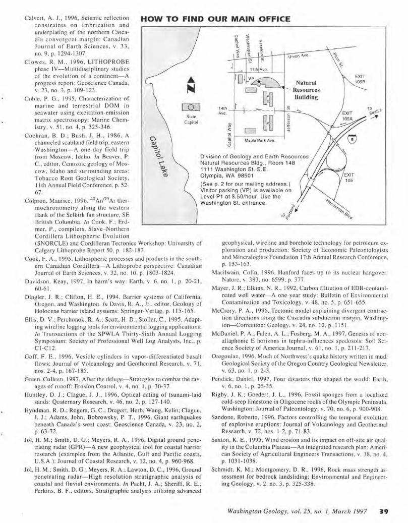
Calvert , A . J., 1996, Seismic reflection constraints on imbrication and underp lating of the northern Cascadi a converge nt margin : Canadian Journ a l or Ea rth Sc iences , v . 33 , no. 9. p. 1294-1 307.
HOW TO FIND OUR MAIN OFFICE
Clowes . R. M ., 1996. LITHOPROBE phase IV-Multidisc ipl inary studies of the evolution of a continent- A progress re port: Geoscience Canada , v. 23 , no. 3, p. 109-123.
Coh le. P. G., 1995, C haracterizati on of marine and terrestrial DOM in sea water using excitation-emission matrix spectroscopy: Marine Chemistry , v. 51. no. 4, p. 325-346.
Stare Capitol
141h Ave ,
11th Ave .
ij
union"'"·
iii
Natural Resources Building
- - - - - - - r--+--..:::_<-.
f EJ ~ :§ 1-------- -l ·a. .. u
Maple Park Ave.
EXIT 105B
Cochran, B. D. ; Bush, J. H. , 1986. A channeled scab land field trip, eastern Washington-A one-day rield trip from Moscow, Idaho. In Beaver, P. C., editor, Cenozoic geology of Moscow, Idaho and surround ing areas :
Division of Geology and Earth Resources Natural Resources Bldg., Room 148
Tobacco Roo t Geological Society , I I th Annual Field Confe rence, p. 52-67.
1111 Washington St . S. E. Olympia, WA 98501
Colpron, Maurice, 1996. 40 Ar/39Ar thermochronometry along the western flank o f the Selkirk fa n strm:t ure, SE
(See p. 2 for our mailing add ress.) Visitor parking (V P) is available on Level P1 at $ .50/hour . Use the Washington St . entrance.
Rritish Columhia. In Cook, F. ; Erd-mer, P., compilers, Slave- Northern Cord i llera Lithospheric Evolution (SNORCLE) and Cordilleran Tecto ni cs Wo rkshop: University of Ca lgary Lithoprobe Report 50, p. 182- 183.
Cook , F. A ., 1995, Lithospheric processes and products in the southern Ca nadian Cordillera- A Lithoprobe perspective: Canadian Journal of Earth Sciences, v. 32 , no. I 0. p. 1803- 1824.
Davidson, Keay, 1997, In harm's way: Earth , v. 6 , no. 1, p. 20-2 1, 60-61 .
Din gler. J . R. ; C li fto n, H. E. , 1994, Barrier systems of California, Oregon, and Washington . In Davis , R. A., Jr. , editor, Geology of Holocene barrier island systems: Springer-Verlag, p. 11 5-165.
Elli s, D. V.; Perchonok, R. A. ; Scott, H. D.; Stoller. C., 1995, Adapting wirelinc logging tools for environmental Jogging appl ications . In Transactions of the SPWLA Thi rty-Sixth An nu a l Logging S ymposium: Society of Professional Well Log Analysts, Inc. , p. CI -Cl2.
Goff. F . E., 1996, Vesic le cy linders in vapor-differentiated basalt flows: Journal of Volcanology and Geothermal Research . v. 71 , nos. 2-4, p. 167- 185.
Green, Colleen. 1997, After the deluge-Strategies to combat the ravages of runoff: Erosion Control. v. 4, no. I , p. 30-37.
Huntley, ID. J.; Clague, J . J., 1996, Optical dating of tsunami-laid sands: Q uaternary Research, v. 46 , no. 2, p. 127- 140.
Hyndman, R. D.; Rogers, G. C.; Dragert, Herb ; Wang, Kclin; Clague, J. J.; Adams, John; Bobrowsky, P. T., 1996, Giant earthquakes beneath Canada's west coast: Geoscience Canada. v. 23, no. 2, p. 63-72.
Joi , H. M.; Smith , D. G.; Meyers, R. A., 1996, Digital ground penetrating radar (GPR)-A new geophysical tool for coastal barrier researc h (examples from the Atlantic, Gulf and Pacific coasts, U.S.A .) : Journal of Coastal Research. v. 12, no. 4, p. 960-968.
Joi, H. M.; Smith, D. G.: Meyers, R. A.; Lawton, D. C., 1996, Ground penetrating radar-High resolution stratigraphic analysis of coasta l and fl uvial environments. In Pacht , J . A .; Sheriff, R. E.; Perkins, B. F., editors, Stratigraphic analysis uti li zing advanced
geophysica l, wireline and borehole technology fo r petroleum explora tion and productio n: Society of Economic Paleonto logi sts and Mine ralogi sts Foundation 17th Annua l Research Conference. p. 153-163.
Maci I wain . Co lin . 1996, Hanford faces up to its nuclear hangover: Nature, v. 383 . no. 6599. p. 377.
Mayer, J. R.: Elkins, N. R .. l 992, Carbon filtration of EDB-contaminated well water- A one-year study: Bulletin or En vironmental Contam ination and Toxicology, v. 48, no. 5 , p. 651 -655.
McCrory, P. A., 1996, Tectonic model explaini ng divergent contraction directions along the Cascadia subduction margin. Washington-Correction : Geology, v. 24. no. 12. p. 115 l.
Mc Dan iel , P.A .; Fa len. A. L. ; Fosberg. M . A., 1997, Ge nesis of nonallaphonic E horizons in tephra-influences s podosols: Soil Science Society of America Journal , v. 61 , no. 1, p. 2 11-2 17.
O regonian, l 996. Much of Northwest' s quake history written in mud: Geological Society of the Oregon Country Geological Newsletter, v. 63. no. I. p. 2-3.
Pendick, Danie l, 1997, Four disasters that shaped the world: Earth . v. 6 , no. I, p. 26-35 .
Rigby , J. K.; Goeden, J. L., 1996, Fossi l sponges from a localized cold-seep limestone in Oligocene rocks or the Olympic Pen insula. Washington: Journal of Paleontology, v. 70, no. 6, p. 900-908.
Sandone, Roberto, 1996, Factors controll ing the temporal evolution of explosive eruptions: Journal of Volcanology and Geothermal Research, v. 72, nos . l -2, p. 71-83.
Saxton. K. E., 1995 , Wind erosion and its impact on off-site ai r quality in the Columbia Plateau-An integrated research plan: American Society of Agri cultural Engineers Transactions, v. 38. no . 4 , p. 1031-1038.
Schmidt. K. M. ; Montgomery, D. R .. l 996. Rock mass strength assessment for bedrock landsliding: Environmental and Engineering Geology , v. 2 , no. 3, p. 325-338.
Washington Geology, vol. 25, no. I, March 1997 3 9
Schult z, A. P.: Crosson, R. S .. 1996. Seismic velocity structure across the central Washington Cascade Range from refraction interpretation with earthquake sources: Jou rnal of Geophysical Research, v. 101, no. 812, p. 27,899-27,915.
Schuster, R . L. , 1994. Hazard mitigation for lands lide da ms . I n Oliveira, R.; Rodrigues, L. F.; Coelho, A. G .; Cunha, A. P., editors, Proceedings-Seventh International Congress, International Associat ion of Engineering Geology; Volume 3, Theme 2, Engineering geology and natu ral hazards: A. A. Balkema. p. I 44 1-1450.
Smith, R. D.; Sidle, R. C.; Porter, P. E., 1993, Effects on bedload transport of experimental removal of woody debri s from a forest grave l-bed stream: Earth Surface Processes and Land forms, v. 18, p. 455-468.
Thiessen, R. L. ; Rieken, E. R., 1993. Deli neation of ac ti ve crusral fau lts in western Washing ton using an integrated remote sensing approach. In Proceedings o f the 9th Thematic Conference on Geologic Remote Sensing-Exploration, Engineering, and Environment: Environmental Research Institute of Michigan, p. 239-249.
Vallance, J . W .; Scoll , K. M .. 1997, The Osceola Mudflow from Mount Ra inier-Sedimentology and hazard implications of a huge clay-rich deb ris flo w: Geological Society of America Bulletin. v. 109, no. 2, p. 143-163 .
Vail , W. B.; Momii, S. T.; Haines, H.; Gou ld, J. F., Jr .; Kenn edy, W . D., 1995, Formation resistivity measurements through metal casing at the MWX- 2 well in Rifl e, Colorado. /11 Transactions o f the SPWLA Thirty-Sixth Annual Logging Symposi um: Society of Professional We ll Log An alysts. In c. , p. 001-0012.
Wang, Ke lin : He, Ji angheng; Davis, E. E., I 997, Transform push, ob lique subduction resistance, and intraplatc stress o f the Juan de Fuca p late: Journal of Geoph ysica l Researc h, v. I 02 , no. BI , p. 66 1-674.
West. M. W.: Ash land, F. X.: Busacca, A. J. ; Berger, G . W. ; Shaffer. M . E. , I 996, Late Quaternary deformation, Saddle Mountains anticline , south-central Washington : Geology . v. 24. no . 12, p. 11 23-11 26.
Youngs, R. R. ; C hiou, S .-J .; Silva, W. J. ; Humphrey, J. R., 1997 , Strong ground motion att enuation relationships for subduction 7.onc earthquakes: Seismological Research Letters, v. 68, no. I , p. 58-73.
•
••• WASHINGTON STATE DEPARTMENT OF
• • ~n~~M1!!~,1 Co~m~~n?o~~~~~ Kaleen Cottingham · Supervisor
Department of Natural Resources Divis ion of Geology and Earth Resources PO Box 47007 Olympia, WA 98504-7007
ADDRESS CORRECTION REQUESTED
OTHER REPORTS OF INTEREST
California Seismic Safety Commission, J 993, The commercial prop-"' erty owne r 's guide to earthquake safety: California Seismic °"' C) Safety Commission , 32 p. ;:,
Madin, l. P. ; Mabey, M. A .. editors , 1996, Earthquake hazard maps ~
for Oregon: Oregon Departme nt of Geology and Mineral Indus- 5'" tries Geological Map Series GMS 100, I sheet. °"'
~ National Mining Association, 1996, Facts about minerals, 1996-97:
National Mining Association , 96 p. "-> U.S. Federal Emergency Management Agency, 1993, Are you ready? _vi
Your guide to disaster preparedness: U.S. Federal Emergency ~
Management Agency, 84 p. _.._
U.S. National Science and Technology Council, 1996, Strategy for national earthqu ake loss reduction : U.S. National Science and Techno logy Council. 4 1 p.
Washington Department of Natural Resources , 1996, Final environmental impact statement- Habitat conservation plan: Washington Department of Natural Resources, 1 v.
Washington Forest Practices Board, 1996, Draft supplementa l environmental impact statement and appendices on forest practices rule proposa ls for the marbled murrelet, sup p leme nts fin al EIS-May 1996: Washing ton De partment of Natural Resources, 1 V.
Washington Fo rest Practices Board, I 996, Final environmental i mpact s tate ment on forest practices rule proposals for nort hern spolled owl, marbled murrelet, western gray squirrel : Washington Forest Prac liccs Board , I v. •
We Now Have a Web Page
URL: http://www.wa.gov/dnr/htdocs/ger/ger .html
Division Release Geologic Map of the Pomeroy Area, Southeastern Washington, Open File Report 96-5 , compiled by Peter R. Hooper and Beth A. Gillespie. A 26 p . tex t accompanies thi s map , scale 1: 38,520. $1.84 + 0. 16 tax (WA residents only) = $2.00.
BULK RATE U .S. POSTAGE PAID
Washington State Oeparlment of Printing