· web viewspacing between multiple towers provides for solar access, cross ventilation and...
TRANSCRIPT
7.2.3.6 Chermside centre neighbourhood plan code
7.2.3.6.1 Application
(1) This code applies to assessing a material change of use, reconfiguring a lot, operational work or building work in the Chermside centre neighbourhood plan area if:
(a) assessable development where this code is an applicable code identified in the assessment criteria column of a table of assessment for a neighbourhood plan (section 5.9); or
(b) impact assessable development.
(2) Land in the Chermside centre neighbourhood plan area is identified on the NPM-003.6 Chermside centre neighbourhood plan map and includes the following precincts:
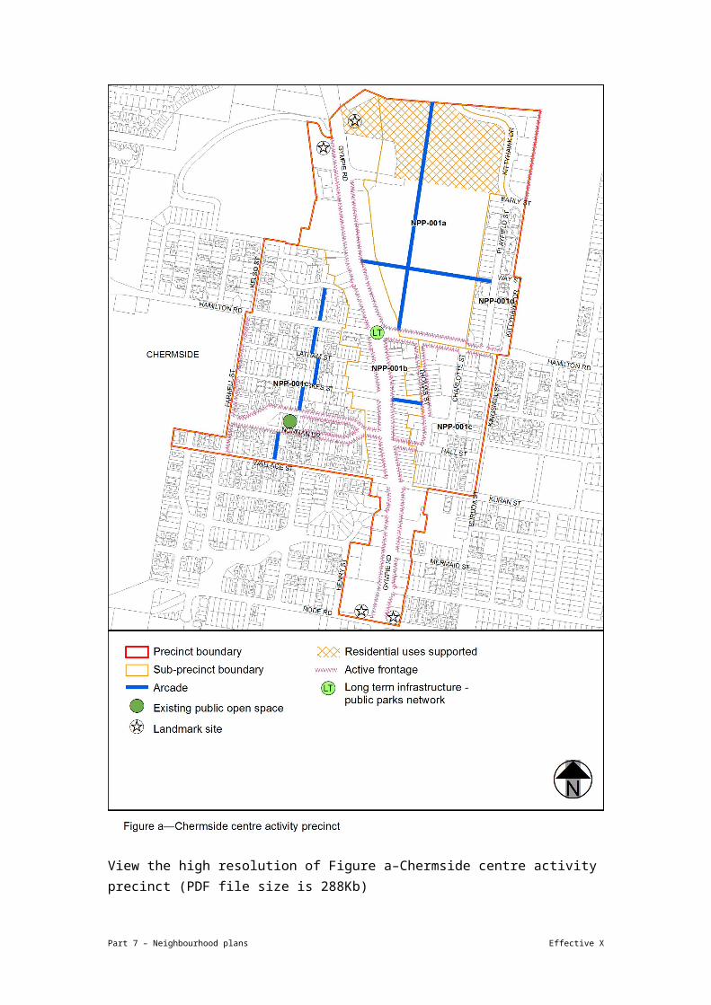
(a) Chermside centre activity precinct (Chermside centre neighbourhood plan/NPP-001):
(i) Core sub-precinct (Chermside centre neighbourhood plan/NPP-001a);
(ii) Gympie Road sub-precinct (Chermside centre neighbourhood plan/NPP-001b);
(iii) Mixed use sub-precinct (Chermside centre neighbourhood plan/NPP-001c);
(iv) Playfield Street sub-precinct (Chermside centre neighbourhood plan/NPP-001d).
(b) Residential north precinct (Chermside centre neighbourhood plan/NPP-002):
(i) High density residential sub-precinct (Chermside centre neighbourhood plan/NPP-002a);
(ii) Wheller Gardens sub-precinct (Chermside centre neighbourhood plan/NPP-002b).
(c) Residential south precinct (Chermside centre neighbourhood plan/NPP-003);
(d) Community use and sports precinct (Chermside centre neighbourhood plan/NPP-004);
(e) Hospital precinct (Chermside centre neighbourhood plan/NPP-005).
(3) When using this code, reference should be made to section 1.5, section 5.3.2 and section 5.3.3.
Note— This neighbourhood plan includes a table of assessment. Refer to Table 5.9.16.A, Table 5.9.16.B, Table 5.9.16.C and Table 5.9.16.D.
Part 7 – Neighbourhood plans Effective X

7.2.3.6.2 Purpose
(1) The purpose of the Chermside centre neighbourhood plan code is to provide finer grained planning at a local level for the Chermside centre neighbourhood plan area.
(2) The purpose of the Chermside centre neighbourhood plan code will be achieved through overall outcomes including overall outcomes for each precinct of the neighbourhood plan area.
(3) The overall outcomes for the neighbourhood plan area are:
(a) The Chermside centre develops as a principal regional activity centre, accessible by high-quality public transport and serves as a focal point for employment, administration, cultural, entertainment, retail and service activities on the north side of Brisbane.
(b) Development is consolidated around key activity nodes being the Prince Charles Hospital, Chermside Shopping Centre and the Gympie Road transit corridor, supporting major activity generators in these areas and using high levels of accessibility.
Editor's note—The Gympie Road transit corridor refers to the Northern Busway.
(c) Development enhances activation of Gympie Road bus station entry points and their immediate surrounds.
(d) Vehicle entrances, servicing and parking are designed and located to facilitate safe pedestrian movement.
(e) Higher density development requires larger sites that will be achieved through lot amalgamation.
(f) Development incorporates arcades to improve pedestrian connections to key destinations.
(g) Development integrates with a network of high-quality, accessible open space and ensures the ecological values of Downfall Creek are maintained. A system of green-space areas, streetscapes and community facilities meet the needs of existing and future residents.
(h) Development within precincts respects adjoining heritage.
(i) Development is of a height, scale and form which is consistent with the amenity and character, community expectations and infrastructure assumptions intended for the relevant precinct, sub-precinct or site and is only developed at a greater height, scale and form where there is both a community need and an economic need for the development.
Part 7 – Neighbourhood plans Effective X

(4) Chermside centre activity precinct (Chermside centre neighbourhood plan/NPP-001) overall outcomes are:
(a) Development achieves a mix of centre uses that attract business and lifestyle opportunities needed to support a principal regional activity centre.
(b) Development provides active frontage uses at ground storey that encourage pedestrian activity and tenancies including shops, food and drinks outlets, health care services and indoor sport and recreation.
(c) Development does not impact on road upgrades or the construction of the Gympie Road transit corridor and associated infrastructure.
(d) Development addresses flooding and overland flow impacts associated with Somerset Creek, a tributary of Downfall Creek (including piped sections).
(e) Development adjoining Downfall Creek provides strong connections to this open space network through building design that addresses the parkland.
(f) Development in the Core sub-precinct (Chermside centre neighbourhood plan/NPP-001a):
(i) of the existing Chermside Shopping Centre provides a greater mix of uses, including commercial development;
(ii) reinforces the intent of the sub-precinct as a Major Centre capitalising on proximity to high-quality public transport;
(iii) ensures that arcades through Chermside Shopping Centre improve access to existing and planned public transport, the community hub north of Hamilton Road, the Downfall Creek open space network and Hamilton Road/Thomas Streets;
(iv) for entertainment uses, including taverns and nightclub entertainment facilities, are consistent with the outcomes sought for this sub-precinct only;
(v) locates residential uses at its northern end and are designed to mitigate higher levels of ambient noise.
(g) Development in the Gympie Road sub-precinct (Chermside centre neighbourhood plan/NPP-001b):
(i) reinforces Chermside as a Major Centre with more-intense development where amalgamation of sites and the minimum site area identified in Table 7.2.3.6.3.B can be achieved;
(ii) provides centre activities with a strong focus on office and shop uses fronting Gympie Road;
Part 7 – Neighbourhood plans Effective X

(iii) locates a residential use on an upper level where designed to mitigate and avoid adverse noise and air-quality impacts;
(iv) creates gateway statements for Chermside centre through landmark building sites to identify the regional significance of the centre;
(v) provides arcades and pedestrian paths where identified, to improve access to the Core sub-precinct (Chermside centre neighbourhood plan/NPP-001a), the Mixed use sub-precinct (Chermside centre neighbourhood plan/NPP-001c) and the Wheller Gardens sub-precinct (Chermside centre neighbourhood plan/NPP-002b);
(vi) fronting Gympie Road limits direct access points by providing parking and delivery access from side streets. Where this is not possible, access is obtained through adjoining properties via access easements.
(h) Development in the Mixed use sub-precinct (Chermside centre neighbourhood plan/NPP-001c):
(i) is primarily residential with active frontage uses located on lower levels;
(ii) for commercial and business activities that are allied with the hospital are consistent with the outcomes sought for this sub-precinct including health care services, research and technology uses and short-term accommodation;
(iii) provides active frontage uses to promote pedestrian activity in Kidston Terrace, Norman Drive, Wallace Street, Thomas Street and Hall Street which are key streets for pedestrian movement between the hospital, Gympie Road and Chermside Shopping Centre;
(iv) west of Gympie Road provides arcades to improve north–south connectivity for pedestrians and cyclists accessing Hamilton Road and John Patterson Park. To the east of Gympie Road, an arcade will improve accessibility between Thomas Street and Gympie Road;
(v) provides a building height transition adjacent to the heritage-listed part of the Wheller Gardens sub-precinct to match the scale of the heritage area.
(i) Development in the Playfield Street sub-precinct (Chermside centre neighbourhood plan/NPP-001d):
(i) integrates with the pedestrian and cycle network and maximises access to adjacent attractions;
(ii) is primarily high-density residential, with opportunities for small-scale retail, restaurants, cafes or office uses at ground storey.
Part 7 – Neighbourhood plans Effective X

(5) Residential north precinct (Chermside centre neighbourhood plan/NPP-002) overall outcomes are:
(a) Residential development caters for diverse groups including the aged and workers and provides short-term accommodation to support the nearby hospital activities and services.
(b) Development provides connections to and addresses the open space network associated with Downfall Creek.
(c) Development in the High density residential sub-precinct (Chermside centre neighbourhood plan/NPP-002a):
(i) provides high density residential development where lot amalgamation can be achieved;
(ii) protects the reasonable amenity of adjoining and nearby areas by transitioning down in height and scale at site boundaries.
(d) Development in the Wheller Gardens sub-precinct (Chermside centre neighbourhood plan/NPP-002b):
(i) provides residential accommodation for senior Brisbane residents;
(ii) provides higher density residential care facility and retirement facility uses;
(iii) maximises pedestrian amenity and access through arcades that increase the permeability to Esplanade Road, nearby services, facilities, residential areas and the Downfall Creek green-space network;
(iv) for any new development protects heritage values and where adjacent to heritage places is sympathetic in height, bulk and scale.
(6) Residential south precinct (Chermside centre neighbourhood plan/NPP-003) overall outcomes are:
(a) Development provides medium density residential development.
(b) Farnell Street, Sammels Drive and Hilltop Avenue are reinforced as key pedestrian and cyclist connections to the hospital and current and future public transport connections within the Gympie Road transit corridor.
(7) Community use and sports precinct (Chermside centre neighbourhood plan/NPP-004) overall outcomes are:
(a) This precinct includes Bradbury Park, Burnie Brae Park and Seventh Brigade Park, including Kedron Wavell Services Club, which are retained and upgraded to service the recreational, sporting and social needs of existing and future residents.
Part 7 – Neighbourhood plans Effective X

(b) Street-scaping and shaded pathways improve the amenity for walking and cycling to these destinations.
(c) Redevelopment and future upgrades manage the impacts of community sport and recreational activities on nearby residents.
(d) Redevelopment of the community hub in Seventh Brigade Park north of Hamilton Road is subject to the development intent of the Chermside Parklands Master Plan.
(e) Development expands on existing indoor and outdoor facilities, providing a wider range of activities for the community.
(f) Development integrates indoor and outdoor spaces to create usable and accessible community facilities.
(g) Development consolidates the building footprint, optimises land holdings and reduces the requirement for additional land.
(h) Development provides non-residential uses located at the corner of Hamilton Road and Kittyhawk Drive.
(i) Development for other impact assessable uses are not consistent with the outcomes sought for the precinct.
(8) Hospital precinct (Chermside centre neighbourhood plan/NPP-005) overall outcomes are:
(a) Development will be prepared in consultation with the Council.
(b) Development is of a scale and intensity consistent with the surrounding precincts.
(c) Development is concentrated to the north-east of the site to maximise proximity to the Mixed use sub-precinct (Chermside centre neighbourhood plan/NPP-001c), High density residential sub-precinct (Chermside centre neighbourhood plan/NPP-002a) and the Wheller Gardens sub-precinct (Chermside Centre neighbourhood plan/NPP-002b).
(d) Development addresses Farnell Street, Hamilton Road and Webster Road and provides a high-quality streetscape with a strong pedestrian focus.
(e) Development provides through connections for pedestrians and cyclists.
(f) Development protects the existing habitat areas of Beneke Bush Nature Area.
(g) Development addresses traffic implications.
7.2.3.6.3 Assessment criteria
The following table identifies assessment criteria for assessable development.
Part 7 – Neighbourhood plans Effective X

Table 7.2.3.6.3.A—Criteria for assessable development
Performance outcomes Acceptable outcomes
General
PO1
Development is of a height, scale and form that achieves the intended outcome for the precinct, improves the amenity of the neighbourhood plan area, contributes to a cohesive streetscape and built form character and is:
(a) consistent with the anticipated density and assumed infrastructure demand;
(b) aligned to community expectations about the number of storeys to be built;
(c) proportionate to and commensurate with the utility of the site area and frontage width;
(d) designed to avoid a significant and undue adverse amenity impact to adjoining development;
(e) sited to enable existing and future buildings to be well separated from each other and to avoid affecting the potential development of adjoining sites.
Note—Development that exceeds the intended number of storeys or building height can place disproportionate pressure on the transport network, public space or community facilities in particular.
Note—Development that is over-scaled for its site can result in an undesirable dominance of vehicle access, parking and manoeuvring areas that significantly reduce streetscape character and amenity.
AO1
Development complies with the number of storeys, building height and gross floor area in Table 7.2.3.6.3.B.
Note—Neighbourhood plans will mostly specify the maximum number of storeys where zone outcomes have been varied in relation to building height. Some neighbourhood plans may also specify the height in metres. Development must comply with both parameters where maximum number of storeys and height in metres are specified.
PO2
Development provides building setbacks that:
(a) create a consistent and cohesive streetscape;
(b) enable existing and future buildings to be well separated from each other to allow light penetration, air circulation and privacy, and ensure windows are not built out by adjoining buildings;
AO2
Development has building setbacks that comply with Table 7.2.3.6.3.D.
Part 7 – Neighbourhood plans Effective X

(c) do not prejudice the development of adjoining sites.
PO3
Development provides for a mix of residential and non-residential uses that provide the level of activity needed to support the role and function of each sub-precinct.
AO3
Development provides a land use mix that complies with Table 7.2.3.6.3.C.
PO4
Development provides a building height transition to the Wheller Gardens Settlement heritage area as shown in Figure b and reinforces the heritage values of this precinct.
AO4
Development that adjoins the Wheller Gardens Settlement heritage area as shown in Figure b:
(a) complies with the number of storeys and building height in Table 7.2.3.6.3.B;
(b) has a minimum setback of 3m from the side and/or rear of the heritage precinct boundary.
PO5
Development contributes to the role of the street as the focus for commercial and community life and promotes activation and casual surveillance through active frontages.
AO5
Development provides active frontages where identified in Figure a.
PO6
Development abutting Kittyhawk Drive and Seventh Brigade Park situates buildings to address both the street frontage and the park to:
(a) improve pedestrian activity at the development interface;
(b) create a sense of safety in the public realm.
AO6
Development provides:
(a) active frontages that focus on and overlook Seventh Brigade Park;
(b) at least 50% of the ground storey of a building with active frontages where adjoining Kittyhawk Drive or the park;
(c) direct access from the street to ground storey residential multiple dwellings;
(d) fences that have a maximum height of 1.5m and are 50% transparent where adjoining Kittyhawk Drive or the park.
PO7
Development that adjoins a busway corridor, transit way, bus stops and future stations:
(a) activates the edges of busway stations and the immediate environment, creating vibrant and attractive street
AO7
No acceptable outcome is prescribed.
Part 7 – Neighbourhood plans Effective X

environments;
(b) enables casual surveillance of busway station platforms, entry points and public spaces;
(c) facilitates safe, logical and direct pedestrian and cyclist access to busway station entry points;
(d) screens views of uninhabited transport infrastructure elements;
(e) screens servicing and utility areas from view of the passenger areas of busway stations;
(f) designs and sites buildings to address busway interface issues;
(g) preserves the structural integrity and ongoing operation and maintenance of transport infrastructure;
(h) provides sufficient on-site servicing and utilities to contain adverse impacts.
PO8
Development supports the creation of a road network that efficiently provides for the movement of traffic and frequent public transport.
AO8.1
Development provides for road widening in accordance with Figure c.
AO8.2
Development is sited and designed so as not to compromise the proposed intersection upgrades indicated in Figure c.
PO9
Development:
(a) creates an integrated pedestrian and cycle network that provides direct access to public transport routes, activity centres and public open space through the provision of arcades;
(b) provides arcades to improve permeability through building design and site layout. Scale, width and design of arcades reflect their function and location.
AO9
Development provides arcades as indicated in Figure a and Figure b.
PO10
Development provides long term
AO10
Development protects land for the provision
Part 7 – Neighbourhood plans Effective X

infrastructure for the parks network to meet the recreational needs of residents and workers
of a park in the general location specified in Figure a and in accordance with the Long term infrastructure plan
If in the Community use and sports precinct (Chermside centre neighbourhood plan/NPP-004) where north of Hamilton Road
PO11
Development achieves the intent of the Chermside Parklands Master Plan park management plan.
AO11
Development is in accordance with the Chermside Parklands Master Plan in the Park management plan planning scheme policy.
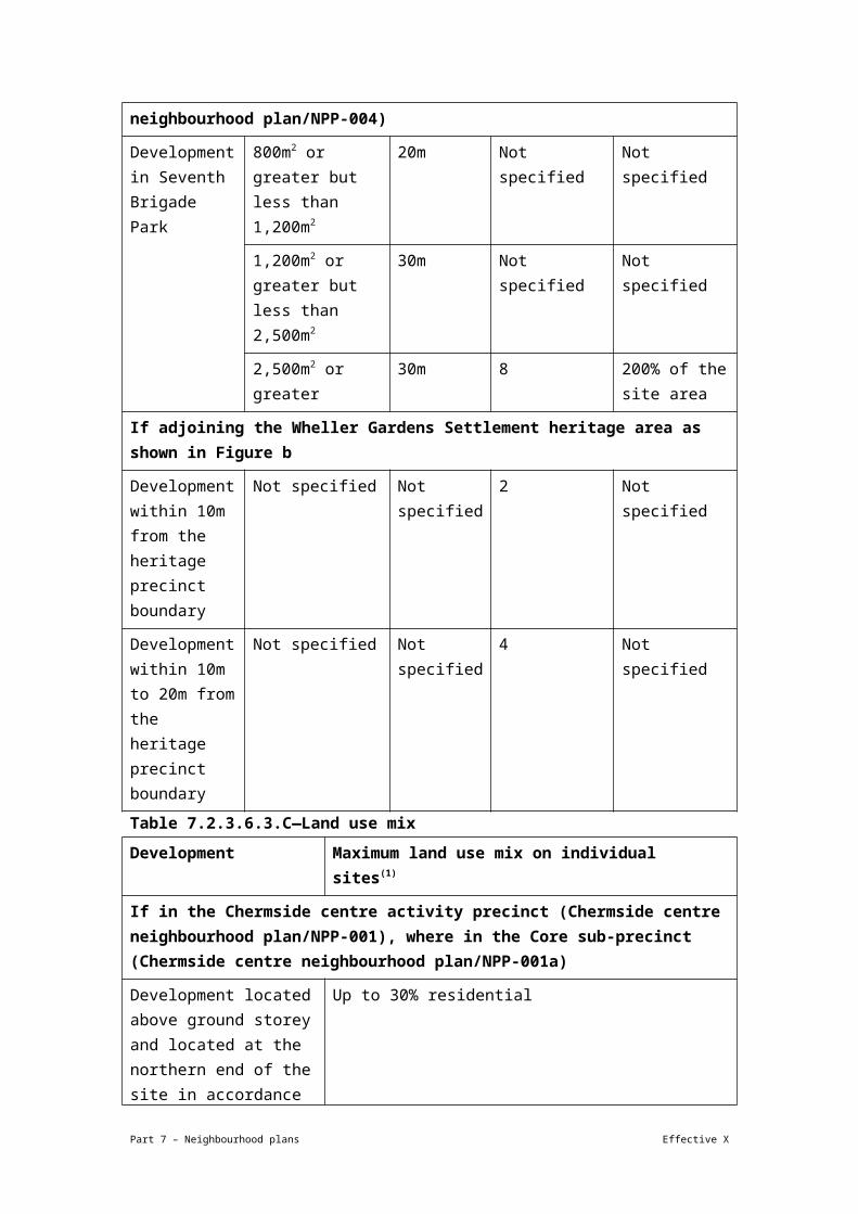
Table 7.2.3.6.3.B—Maximum building height and gross floor area
Development Site area Minimum site frontage
Maximum building height (storeys)
Maximum gross floor area
If in the Chermside centre activity precinct (Chermside centre neighbourhood plan/NPP-001), where in the Core sub-precinct (Chermside centre neighbourhood plan/NPP-001a)
Any development in this precinct
800m² or greater but less than 1,200m²
20m 6 150% of the site area
1,200m2 or greater but less than 2,500m2
30m 12 300% of the site area
2,500m2 or greater 30m 15 400% of the site area
Any other case 6 150% of the site area
If in the Chermside centre activity precinct (Chermside centre neighbourhood plan/NPP-001), where in the Gympie Road sub-precinct (Chermside centre neighbourhood plan/NPP-001b)
Any development in this precinct
800m2 or greater but less than 1,200m2
20m 6 150% of the site area
1,200m2 or greater but less than 2,500m2
30m 12 300% of the site area
2,500m2 or greater 30m 15 400% of the site area
If in the Chermside centre activity precinct (Chermside centre neighbourhood plan/NPP-001), where in the Mixed use sub-precinct (Chermside centre neighbourhood plan/NPP-001c)
Part 7 – Neighbourhood plans Effective X

Any development in this precinct
800m2 or greater but less than 1,200m2
20m 6 150% of the site area
1,200m2 or greater but less than 2,500m2
30m 12 300% of the site area
2,500m2 or greater 30m 12 300% of the site area
If in the Chermside centre activity precinct (Chermside centre neighbourhood plan/NPP-001), where in the Playfield Street sub-precinct (Chermside centre neighbourhood plan/NPP-001d)
Any development in this precinct
800m2 or greater but less than 1,200m2
20m 6 150% of the site area
1,200m2 or greater but less than 2,500m2
30m 12 300% of the site area
2,500m2 or greater 30m 12 300% of the site area
If in the Residential north precinct (Chermside centre neighbourhood plan/NPP-002), where in the High density residential sub-precinct (Chermside centre neighbourhood plan/NPP-002a)
Any development in this precinct
800m2 or greater but less than 1,200m2
20m 6 150% of the site area
1,200m2 or greater but less than 2,500m2
30m 8 200% of the site area
2,500m2 or greater 30m 10 250% of the site area
Any other case 6 150% of the site area
If in the Residential north precinct (Chermside centre neighbourhood plan/NPP-002), where in the Wheller Gardens sub-precinct (Chermside centre neighbourhood plan/NPP-002b)
Any development in this precinct
800m2 or greater but less than 1,200m2
20m Not specified Not specified
1,200m2 or greater 30m Not specified Not specified
Part 7 – Neighbourhood plans Effective X

but less than 2,500m2
2,500m2 or greater 30m 10 250% of the site area
If in the Residential south precinct (Chermside centre neighbourhood plan/NPP-003)
Any development in this precinct
800m2 or greater but less than 1,200m2
20m 4 100% of the site area
1,200m2 or greater but less than 2,500m2
30m 6 150% of the site area
2,500m2 or greater 30m 6 150% of the site area
Any other case 4 100% of the site area
If in the Community use and sports precinct (Chermside centre neighbourhood plan/NPP-004)
Development in Seventh Brigade Park
800m2 or greater but less than 1,200m2
20m Not specified Not specified
1,200m2 or greater but less than 2,500m2
30m Not specified Not specified
2,500m2 or greater 30m 8 200% of the site area
If adjoining the Wheller Gardens Settlement heritage area as shown in Figure b
Development within 10m from the heritage precinct boundary
Not specified Not specified 2 Not specified
Development within 10m to 20m from the heritage precinct boundary
Not specified Not specified 4 Not specified
Part 7 – Neighbourhood plans Effective X

Table 7.2.3.6.3.C—Land use mix
Development Maximum land use mix on individual sites(1)
If in the Chermside centre activity precinct (Chermside centre neighbourhood plan/NPP-001), where in the Core sub-precinct (Chermside centre neighbourhood plan/NPP-001a)
Development located above ground storey and located at the northern end of the site in accordance with Figure a
Up to 30% residential
If in the Chermside centre activity precinct (Chermside centre neighbourhood plan/NPP-001), where in the Gympie Road sub-precinct (Chermside centre neighbourhood plan/NPP-001b)
Any development in this precinct
Up to 60% residential
If in the Chermside centre activity precinct (Chermside centre neighbourhood plan/NPP-001), where in the Mixed use sub-precinct (Chermside centre neighbourhood plan/NPP-001c)
Development located on an active street frontage (Figure a)
Up to 50% non-residential
Development not located on an active street frontage (Figure a)
Up to 10% non-residential
If in the Residential north precinct (Chermside centre neighbourhood plan/NPP-002), where in the Wheller Gardens sub-precinct (Chermside centre neighbourhood plan/NPP-002b)
Any development in this precinct
A minimum of 75% residential care facilities or retirement facilities
Note—
(1) Developments that achieve a similar mix for the overall sub-precinct will be considered as performance outcomes.
Table 7.2.3.6.3.D—Built form setbacks
Development Minimum setback (including balconies)
Setbacks to level 1 (ground storey)
Setbacks level 2–4
Setbacks level 5–8
Setbacks level 9 and above
If in the Chermside centre activity precinct (Chermside centre neighbourhood plan/NPP-001), where in the Gympie Road sub-precinct (Chermside centre neighbourhood plan/NPP-001b) but excluding the Chermside Shopping Centre component of the Gympie Road sub-
Part 7 – Neighbourhood plans Effective X

precinct (Chermside centre neighbourhood plan/NPP-001b)
Development of a site less than 1,200m2 and/or having a developable site area less than 30m by 30m
Front – 3m
Side – 0m
Rear – 6m
Where a podium level:
Front – 0m
Side – 0m
Rear – 6m
Otherwise:
Front – 0m
Side – 3m
Rear – 6m
Front – 3m
Side – 3m
Rear – 9m
Not specified
Development of a site 1,200m2 and greater
Front – 3m
Side – 0m
Rear – 6m
Front – 0m
Side – 0m
Rear – 6m
Front – 3m
Side – 3m
Rear – 6m
12m between towers
Front – 6m
12m between towers
If in the Chermside centre activity precinct (Chermside centre neighbourhood plan/NPP-001), where in the Mixed use sub-precinct (Chermside centre neighbourhood plan/NPP-001c) and on an active frontage street as identified in Figure a or commercial development proposed at lower levels
Development of a site less than 1,200m2 and having a developable site area less than 30m by 30m
Front – 3m
Side – 0m
Rear – 6m
Front – 0m
Side – 0m
Rear – 6m
Front – 3m
Side – 3m
Rear – 9m
Front – 6m
Side – 3m
Rear – 9m
Development of a site 1,200m2 and greater and having a developable site area at least 30m by 30m
Front – 3m
Side – 0m
Rear – 6m
Front – 0m
Side – 0m
Rear – 6m
Front – 3m
Side – 3m
Rear – 6m
12m between towers
Front – 6m
Side – 3m
Rear – 6m
12m between towers
If in the Community use and sports precinct (Chermside centre neighbourhood plan/NPP-004)
Development of a site in Seventh Brigade Park
Subject to Chermside Parklands master plan – Park management planning scheme policy
Part 7 – Neighbourhood plans Effective X

View the high resolution of Figure a–Chermside centre activity precinct (PDF file size is 288Kb)
Part 7 – Neighbourhood plans Effective X

View the high resolution of Figure b–Residential north precinct (PDF file size is 142Kb)
Part 7 – Neighbourhood plans Effective X
View the high resolution of Figure c–Pedestrian and cycle connections and upgrades (PDF file size is 312Kb)
Part 7 – Neighbourhood plans Effective X

7.2.9.1 Indooroopilly centre neighbourhood plan code
7.2.9.1.1 Application
(1) This code applies to assessing a material change of use, reconfiguring a lot, operational work or building work in the Indooroopilly centre neighbourhood plan area if:
(a) assessable development where this code is an applicable code identified in the assessment criteria column of a table of assessment for a neighbourhood plan (section 5.9); or
(b) impact assessable development.
(2) Land in the Indooroopilly centre neighbourhood plan area is identified on the NPM-009.1 Indooroopilly centre neighbourhood plan map and includes the following precincts:
(a) Multi-purpose centre precinct (Indooroopilly centre neighbourhood plan/NPP-001):
(i) High Street sub-precinct (Indooroopilly centre neighbourhood plan/NPP-001a);
(ii) Moggill Road north sub-precinct (Indooroopilly centre neighbourhood plan/NPP-001b);
(iii) Indooroopilly shopping centre mixed use sub-precinct (Indooroopilly centre neighbourhood plan/NPP-001c);
(b) Witton Barracks precinct (Indooroopilly centre neighbourhood plan/NPP-002);
(c) Special context area precinct (Indooroopilly centre neighbourhood plan/NPP-003):
(i) Jackson Street special context area sub-precinct (Indooroopilly centre neighbourhood plan/NPP-003a);
(ii) Moggill Road west special context area sub-precinct (Indooroopilly centre neighbourhood plan/NPP-003b).
(3) When using this code, reference should be made to section 1.5, section 5.3.2 and section 5.3.3.
Note—This neighbourhood plan includes a table of assessment with level of assessment variations to those in sections 5.5, 5.6, 5.7, 5.8 and 5.10. Refer to Table 5.9.30.A, Table 5.9.30.B, Table 5.9.30.C and Table 5.9.30.D.
7.2.9.1.2 Purpose
(1) The purpose of the Indooroopilly centre neighbourhood plan code is to provide finer grained planning at a local level for the Indooroopilly centre district neighbourhood plan area.
Part 7 – Neighbourhood plans Effective X

(2) The purpose of the Indooroopilly centre neighbourhood plan code will be achieved through overall outcomes including overall outcomes for each precinct of the neighbourhood plan area.
(3) The overall outcomes for the Indooroopilly centre neighbourhood plan area are:
(a) Indooroopilly centre develops as a centre and will build on the strength of its existing retail, commercial and community sectors to become the principal location for these activities in western Brisbane.
(b) Development creates a diverse, integrated, mixed use centre hosting retail and commercial office uses, higher density dwellings and a range of community and recreational facilities that are concentrated around existing and future public transport nodes to encourage greater use of public transport services and attract further investment in new public transport facilities in and serving Indooroopilly centre.
(c) Development is of a height, scale and design that is consistent with the intended height, bulk and character of the relevant precinct and does not result in a density that would place disproportionate pressure on transport infrastructure, public space or community facilities.
(d) Open space, including Keating Park and the former Witton Barracks, is an integral part of the local active transport network and offers a variety of accessible and comfortable community meeting places and recreational spaces.
(e) New houses and other development in areas with strong traditional architectural character of buildings built in 1946 or before, complement traditional streetscape characteristics and in specified residential areas along highly trafficked roads, the introduction of appropriate new uses is encouraged, where this leads to the preservation of heritage or character buildings.
(f) A range of community facilities and services is supported within the neighbourhood plan area that caters for residents, employees and visitors. New development assists in the provision of community spaces to meet the needs of the growing local community. Community facilities are encouraged to co-locate with public and private open space.
(g) Higher density development requires larger sites that will be achieved through lot amalgamation.
(h) Development is of a height, scale and form, including expansive podium and tower element, which does not adversely compromise air quality and is consistent with the amenity, character, community expectations and infrastructure assumptions intended for the precinct.
(4) Multi-purpose centre precinct (Indooroopilly Centre neighbourhood plan/NPP-001) overall outcomes are:
Part 7 – Neighbourhood plans Effective X

(a) Higher density mixed use development is concentrated in the heart of Indooroopilly between the railway line, Moggill Road, Musgrave Road and Station Road. The Indooroopilly Railway Station and bus interchange will promote high levels of public transport patronage and reinforce the precinct as a Major Centre to be developed using the principles of transit oriented development and sustainability. It is anticipated that a new bus interchange will be established in this precinct.
(b) The southern side of Moggill Road emerges as a key employment area, meeting the needs of a range of commercial activities that benefit from proximity and exposure to an arterial road. Mixed use development results in the formation of commercial activities located on the ground storey, with offices located on the upper floors. In order to protect future residents from the impacts of traffic noise, and to maintain supply of valuable and scarce employment land the neighbourhood plan area, new residential development along the southern side of Moggill Road is not consistent with the outcomes sought for this precinct.
(c) Redevelopment of the ‘Westpoint Autos’ site on Moggill Road, being Lot 1 on SP104846, Lot 22 on RP23680, Lot 23 on RP23680 and Lot 24 on RP23680, integrates with its predominantly residential surrounds. Buildings, including parking structures, are set back from site frontages and do not visually dominate. Redevelopment and intensification of land on the northern side of Moggill Road is not consistent with the outcomes sought for this precinct. Future possible road upgrades and widening of Moggill Road is an outcome that is consistent with this precinct.
(d) The land use mix and building design of mixed use development elsewhere in the precinct supports the creation of vibrant, interesting and active ground-storey shopping streets, with high density residential uses above.
(e) Existing vehicular accesses along Moggill Road, Station Road and Coonan Street are consolidated and new public or private accesses to these roads are not provided. Commercial servicing for properties on these roads occurs principally from rear lanes wherever possible.
(f) Development will require the upgrade of the existing substation to a bulk supply substation.
(g) Development in the High Street sub-precinct (Indooroopilly centre neighbourhood plan/NPP-001a):
(i) ensures that Station Road and Lambert Road develop as western Brisbane’s premier retail, entertainment and outdoor dining destination and complement the Indooroopilly Shopping Centre. It capitalises on its role as a primary pedestrian connection between the rail station and bus interchange and the high pedestrian volumes using the street;
Part 7 – Neighbourhood plans Effective X
(ii) establishes a comfortable, safe and convenient east–west pedestrian linkage between the Indooroopilly Shopping Centre, the rail station and Lambert Road through footway widening and streetscape improvements;
(iii) adjoining the sub-precinct promotes the economic revitalisation of businesses located along Station Road and Lambert Road through the creation of a vibrant and active streetscape;
(iv) provides streetscape and public domain treatments with a unique sense of place. This may be achieved by drawing from the Aboriginal name for Indooroopilly, ‘Yindurupilly’, one meaning of which is ‘gully of running water’. Development results in:
(A) a building’s bulk and scale that sensitively responds to changes in terrain and slope;
(B) new public outdoor dining spaces that take advantage of the steep slope of Station Road;
(C) shaded, cool pedestrian environments and wide shopfront awnings;
(D) generous tree planting and landscaping with the predominant use of indigenous tree and plant species;
(E) footways that cater to the needs of users with a range of mobility requirements.
(h) Development in the Moggill Road north sub-precinct (Indooroopilly centre neighbourhood plan/NPP-001b):
(i) transforms it to create a distinctive entry to the Indooroopilly centre through redevelopment and strategic transport infrastructure;
(ii) comprises a mix of employment uses, with retail and commercial activities on ground storey and offices above. Residential development is not supported due to the amenity impacts associated with existing and proposed transport infrastructure;
(iii) transforms the junction of Coonan Street and Moggill Road in accordance with Figure a. The long-term future widening of Moggill Road will also trigger land dedication as part of any redevelopment in this sub-precinct. Land that is no longer required for road purposes is to be consolidated for future non-residential development as shown in Figure b.
(i) Development in the Indooroopilly shopping centre mixed use sub-precinct (Indooroopilly centre neighbourhood plan/NPP-001c):
Part 7 – Neighbourhood plans Effective X

(i) ensures the efficient operation of the Indooroopilly shopping centre and encourages mixed use redevelopment of the Indooroopilly shopping centre site through provision of new residential uses;
(ii) for significant expansion or redevelopment of the Indooroopilly shopping centre site is to:
(A) reduce the relative size and scale of the external walls and facades;
(B) break through the edges of the existing ‘big box’ so it activates the centre;
(C) improve pedestrian accessibility into and through the sub-precinct;
(D) ensure the amenity of neighbouring residential properties is high;
(E) minimise the impacts of traffic, including service vehicles;
(F) screen in servicing and utility areas.
(iii) orientates towards, and sensitively integrates with Keating Park and complements its role and function as local open space and a community gathering area;
(iv) encourages publicly accessible open space at the rooftop level of the Indooroopilly shopping centre as a way of supplementing open space resources at street level;
(v) at the northern end of the Indooroopilly shopping centre takes into account the higher level of pedestrian connectivity needed to this area.
(5) Witton Barracks precinct (Indooroopilly centre neighbourhood plan/NPP-002) overall outcomes are:
(a) Should redevelopment occur at the Witton Barracks, the preferred future use of the site and existing buildings is public open space, community facilities, retail and commercial activity.
(b) The heritage-listed buildings on site are retained and adaptively re-used for small-scale retail and commercial activities where it preserves the buildings and accords with the historic characteristics of the site.
(c) Any new development supports and contributes to the formation of pedestrian and cycle links along the Brisbane River and retention of views from public areas to the Brisbane River, Walter Taylor Bridge and Mt Coot-tha.
(d) Development also provides land for future transport infrastructure located along the western boundary of the site.
Part 7 – Neighbourhood plans Effective X

(6) Special context area precinct (Indooroopilly centre neighbourhood plan/NPP-003) overall outcomes are:
(a) Development in the Jackson Street special context area sub-precinct (Indooroopilly centre neighbourhood plan/NPP-003a):
(i) retains the cluster of high-quality houses built in 1946 or before and heritage buildings contained in this residential area;
(ii) ensures that new building works and modifications to existing buildings are sympathetic to the traditional characteristics of the building and nearby buildings.
(b) Moggill Road west special context area sub-precinct (Indooroopilly centre neighbourhood plan/NPP-003b) contains a cluster of houses built in 1946 or before located along Moggill Road. Its arterial road function and noise levels significantly impact on residential amenity. Development in this sub-precinct:
(i) supports adaptive re-use by non-residential uses to maintain the existing character buildings and address noise issues;
(ii) prefers low-intensity non-residential uses to protect the amenity of surrounding residential area and ensures no additional vehicle accesses to Moggill Road are provided;
(iii) has the following uses consistent with the outcomes sought for the precinct where involving a new premises or increase in gross floor area:
(G) club, community use, health care services, office, shop and veterinary services if in the Low density residential zone;
(H) low impact industry and service industry if no greater than 100m² gross floor area where in the Low density residential zone;
(I) service industry if no greater than 100m² gross floor area where in the Mixed use zone.
(iv) ensures that buildings continue to present a residential appearance and character to the street, regardless of use.
7.2.9.1.3 Assessment criteria
The following table identifies the assessment criteria for assessable development.
Table 7.2.9.1.3.A—Criteria for assessable development
Performance outcomes Acceptable outcomes
General
PO1 AO1
Part 7 – Neighbourhood plans Effective X

Development is of a height, scale and form that achieves the intended outcome for the precinct, improves the amenity of the neighbourhood plan area, contributes to a cohesive streetscape and built form character and is:
(a) consistent with the anticipated density and assumed infrastructure demand;
(b) aligned with community expectations about the number of storeys to be built;
(c) proportionate to and commensurate with the utility of the site area and frontage width;
(d) designed to avoid a significant and undue adverse amenity impact to adjoining development;
(e) sited to enable existing and future buildings to be well separated from each other and to avoid affecting the potential development of an adjoining site.
Note—Development that exceeds the intended number of storeys or building height can place disproportionate pressure on the transport network, public space or community facilities in particular.
Note—Development that is over-scaled for its site can result in an undesirable dominance of vehicle access, parking and manoeuvring areas that significantly reduce streetscape character and amenity.
Development complies with:
(a) the number of storeys and building height in Table 7.2.9.1.3.B;
(b) the maximum gross floor area in Table 7.2.9.1.3.C;
(c) the boundary setbacks in Table 7.2.9.1.3.D.
Note—Neighbourhood plans will mostly specify a maximum number of storeys where zone outcomes have been varied in relation to building height. Some neighbourhood plans may also specify height in metres. Development must comply with both parameters where maximum number of storeys and height in metres are specified.
Note—Where development is located in a street that is subject to a road widening requirement, the new property alignment, after the proposed widening, is regarded as the street front property boundary.
PO2
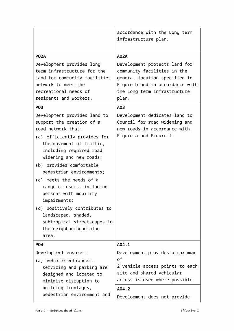
Development provides long term infrastructure for the parks network to meet the recreational needs of residents and workers.
AO2.1
Development provides land for a new park in the location specified as Future park in Figure b and the Local government infrastructure plan.
Part 7 – Neighbourhood plans Effective X
AO2.2
Development protects land for the provision of park in the general location specified in Figure b annotation 'A' and in accordance with the Long term infrastructure plan.
PO2A
Development provides long term infrastructure for the land for community facilities network to meet the recreational needs of residents and workers.
AO2A
Development protects land for community facilities in the general location specified in Figure b and in accordance with the Long term infrastructure plan.
PO3
Development provides land to support the creation of a road network that:
(a) efficiently provides for the movement of traffic, including required road widening and new roads;
(b) provides comfortable pedestrian environments;
(c) meets the needs of a range of users, including persons with mobility impairments;
(d) positively contributes to landscaped, shaded, subtropical streetscapes in the neighbourhood plan area.
AO3
Development dedicates land to Council for road widening and new roads in accordance with Figure a and Figure f.
PO4
Development ensures:
(a) vehicle entrances, servicing and parking are designed and located to minimise disruption to building frontages, pedestrian environment and to reduce the visual impact on the street environment;
(b) pedestrian movement, comfort and safety is maximised in areas of high pedestrian usage by reducing pedestrian and vehicular conflict;
(c) driveway crossovers maintain the integrity, quality and primacy of
AO4.1
Development provides a maximum of 2 vehicle access points to each site and shared vehicular access is used where possible.
AO4.2
Development does not provide vehicular access from a primary frontage where an alternative access is available by a side street or rear service lane.
AO4.3
Development provides rear service lanes to adjoining properties from the nearest public
Part 7 – Neighbourhood plans Effective X

footpaths. road to enable vehicular access and servicing as indicated in Figure b.
Note—It may be necessary to provide a number of lanes within a city block to service all properties.
Note—Rear service lane locations are indicative and should be read as specifying intent to achieve alternative access and servicing to adjoining sites.
AO4.4
Development creates easements over rear service lanes benefiting all parties to the easement, including adjoining owners and the Council, in perpetuity if the Council determines that these are to serve more than 1 individual development or property.
PO5
Development ensures the scale, width, design and tenure of an arcade to reflect its function and location.
AO5
Development provides an arcade as indicated in Figure b.
Note—Arcades are shown in the general location in which they are needed.
PO6
Development within or adjacent to the rail corridor ensures the safety, amenity and preservation of the integrity of the rail corridor without operational restrictions.
AO6
No acceptable outcome is prescribed
If in the Multi-purpose centre precinct (Indooroopilly centre neighbourhood plan/NPP-001)
PO7
Development includes a mix of commercial and residential uses that provide the level of activity needed to support the role and function of each sub-precinct and street in the centre.
AO7
Development on land fronting the following streets achieves the specified land use mixes:
(a) Moggill Road and Coonan Street – non-residential (shop and office) activities;
(b) Station Road and Lambert Road – non-residential (shop, food and drink outlet being a cafe or a restaurant, office) on the ground storey and podium levels and residential above podium level;
(c) all other streets – residential activities.
PO8
Development provides a built form typology that facilitates the preferred land
AO8
Development provides a built form:
(a) fronting Coonan Street, Moggill Road,
Part 7 – Neighbourhood plans Effective X
uses and reinforces the character of the street.
Station Road and Lambert Road, incorporates a podium and tower typology in accordance with Figure d;
(b) fronting any other street, incorporates a podium sleeve and tower typology as specified in Figure e.
PO9
Development includes a podium and tower that:
(a) facilitates increased residential and non-residential uses;
(b) avoids the creation of a ‘canyon’ of buildings along streets;
(c) minimises the visual impacts of tall buildings from street level;
(d) minimises the impacts on adjoining buildings;
(e) positively contributes to an attractive landscaped urban character in the centre;
(f) allows air flow between buildings and views through the site.
AO9.1
Development with a podium typology and tower complies with the minimum setbacks in Table 7.2.9.1.3.D.
AO9.2
Development ensures if a commercial podium is proposed and residential uses exist on an adjoining site at the ground or first storey, the maximum height of the podium is 2 storeys at that side boundary.
AO9.3
Development ensures that the podiums of a building are:
(a) built to the side boundary for a minimum distance of 10m from the front property boundary, except if:
(i) there is a requirement for the provision of an overland flow path; or
(ii) the site adjoins the boundary of a property outside the precinct;
(b) if (a)(i) or (ii) apply, no part of the development is less than 2m from the boundary with the adjoining property.
AO9.4
Development ensures that a building with towers above a podium has the towers separated by a distance of at least 12m.
Note—This is only applicable where there is more than 1 tower within a site.
AO9.5
Development ensures that a building incorporating a podium design includes landscape areas at roof top level.
AO9.6
Part 7 – Neighbourhood plans Effective X

Development which locates car parking within podiums ensures parking is sleeved by active uses so it is not visible from any street.
AO9.7
Development ensures that the podium levels of a building have minimum floor-to-floor height of 4m.
AO9.8
Development has podium and tower roof space designed for use as communal open space that is directly accessible from tenancies or units, remains unenclosed and screens and soundproofs utility areas.
AO9.9
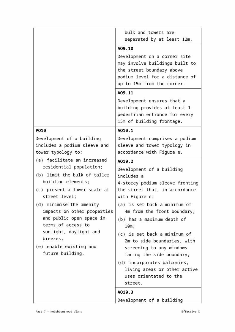
Development of residential, commercial or mixed use multi-storey buildings including balconies:
(a) are a maximum length of 30m in any direction;
(b) extend for no more than 75% of the width of the property;
(c) on a large site comprise more than 1 tower to reduce bulk and towers are separated by at least 12m.
AO9.10
Development on a corner site may involve buildings built to the street boundary above podium level for a distance of up to 15m from the corner.
AO9.11
Development ensures that a building provides at least 1 pedestrian entrance for every 15m of building frontage.
PO10
Development of a building includes a podium sleeve and tower typology to:
(a) facilitate an increased residential population;
(b) limit the bulk of taller building elements;
AO10.1
Development comprises a podium sleeve and tower typology in accordance with Figure e.
AO10.2
Development of a building includes a 4-storey podium sleeve fronting the street that, in accordance with Figure e:
Part 7 – Neighbourhood plans Effective X

(c) present a lower scale at street level;
(d) minimise the amenity impacts on other properties and public open space in terms of access to sunlight, daylight and breezes;
(e) enable existing and future building.
(a) is set back a minimum of 4m from the front boundary;
(b) has a maximum depth of 10m;
(c) is set back a minimum of 2m to side boundaries, with screening to any windows facing the side boundary;
(d) incorporates balconies, living areas or other active uses orientated to the street.
AO10.3
Development of a building including a tower element above 4 storeys is set back a minimum of:
(a) 5m from the side boundaries;
(b) 10m from the rear boundary;
(c) 7m from the front boundary.
Note—Refer to Figure e.
AO10.4
Development of a building:
(a) provides a maximum horizontal dimension for any tower of 30m on any 1 side or 75% the width of the site;
(b) on a large site comprises more than 1 tower to reduce bulk and towers are separated by at least 12m.
AO10.5
Development designs buildings to ensure that the outlook from dwelling units is to the front and rear of the block to minimise the potential for direct interfacing or overlooking.
If in the Multi-purpose centre precinct (Indooroopilly centre neighbourhood plan/NPP-001), where in or fronting the High Street sub-precinct (Indooroopilly centre neighbourhood plan/NPP-001a)
PO11
Development in the sub-precinct supports the formation of a high-quality public domain along Station Road and Lambert Road. In particular, development:
(a) creates a distinctive streetscape character reflecting the need to provide attractive, cool, interesting pedestrian
AO11
No acceptable outcome is prescribed.
Part 7 – Neighbourhood plans Effective X
amenity;
(b) provides continuous shade by generous awnings and mature tree planting;
(c) provides outdoor dining areas that promote the vibrancy and amenity of the streetscape.
If in the Multi-purpose centre precinct (Indooroopilly centre neighbourhood plan/NPP-001), where in the Moggill Road north sub-precinct (Indooroopilly centre neighbourhood plan/NPP-001b)
PO12
Development within the sub-precinct does not prevent or negatively impact on the need to provide:
(a) transport infrastructure;
(b) public transport;
(c) public open space.
AO12
Development for non-residential (shop, office and commercial) purposes specifies:
(a) location and sequencing of major transport infrastructure;
(b) road network, site access and servicing;
(c) land use and built form.
Note—Compliance can be achieved by preparing a structure plan. The relevant provisions of this neighbourhood plan are to inform the development of the structure plan.
If in the Multi-purpose centre precinct (Indooroopilly centre neighbourhood plan/NPP-001), where in the Indooroopilly shopping centre mixed use sub-precinct (Indooroopilly centre neighbourhood plan/NPP001c)
PO13
Development or expansion of the Indooroopilly Shopping Centre achieves the following:
(a) diversified land uses, including shops, offices and accommodation activities;
(b) building bulk and scale is reduced through the use of podium and tower building typology elements;
(c) podium elements are built to the street frontage;
(d) podium wall planes are articulated by providing recesses and projections and by using a range of materials, including glass, that avoid creating featureless or overbearing building facades;
(e) tower heights are varied in response to the topography of the site and ensure a dynamic roof plane that adds to the
AO13
No acceptable outcome is prescribed.
Note—The relevant provisions of this code are to inform a supporting structure plan prepared in accordance with the Structure planning planning scheme policy.
Part 7 – Neighbourhood plans Effective X

appearance of the townscape;
(f) tower elements are set back a minimum of 10m from the street frontage to reduce the visual dominance of the building in the streetscape;
(g) individual tower elements have a maximum building footprint of 1,200m²;
(h) tower elements are separated by a minimum of 12m to minimise amenity impacts;
(i) active street frontages are achieved along Station Road, Stamford Road and Musgrave Road by providing tenancies that are orientated to the street and accommodate centre activities;
(j) visible and connected pedestrian entries separated from driveways are provided along Station Road, Stamford Road and Musgrave Road;
(k) pedestrian movement is facilitated between the sub-precinct and any bus interchange area;
(l) significant trees are provided at the corners of the site;
(m) car parking areas located at ground level or above ground do not directly front the street and are sleeved with centre activity land uses to enhance the vibrancy of the centre and ensure safe streets;
(n) permanent new structures and buildings are not located within the future road upgrade/widening corridor shown in Figure a and Figure f;
(o) development takes into account the possible future bus interchange in the general location indicated in Figure b.
PO14
Development of a new residential use provides space for a community use facility
AO14.1
Development provides a district community use facility of a minimum size of 500m² that is
Part 7 – Neighbourhood plans Effective X

that meets the needs of the population. integrated into the development and is accessible to the public at all times.
AO14.2
Development:
(a) dedicates the community use for exclusive use to the Council; or
(b) privately owns and manages the community use and leases it to the Council.
AO14.3
Development of a community use facility incorporates a layout that includes a range of large flexible rooms for a community hall, neighbourhood activity centre and community hub activities and meeting rooms.
Note—This requirement does not apply where such a community facility has already been provided.
If in the Witton Barracks precinct (Indooroopilly centre neighbourhood plan/NPP-002)
PO15
Development:
(a) supports an integrated, high-quality district park and small-scale commercial and community use;
(b) maintains the landscape qualities on the site;
(c) allows public footpaths and cycleway connections through the site and along the Brisbane River;
(d) preserves the major transport infrastructure corridor on site and ensures impact on the recreational and amenity values of the land is minimised;
(e) maintains locally significant views and vistas to the Brisbane River, Walter Taylor Bridge and Mt Coot-tha;
(f) maintains and adaptively re-uses the heritage buildings on site;
(g) limits the impact of any new development on the heritage qualities
AO15
No acceptable outcome is prescribed.
Part 7 – Neighbourhood plans Effective X

and low-density character of the area to the east of the rail line.
Note—A structure plan prepared in accordance with the Structure planning planning scheme policy can assist in demonstrating achievement of this outcome.
If in the Special context area precinct (Indooroopilly centre neighbourhood plan/NPP-003), where in the Jackson Street special context area sub-precinct (Indooroopilly centre neighbourhood plan/NPP-003a)
PO16
Development of a building reflects the rhythm, setting and building line of nearby buildings built in 1946 or before in the street to the east of the railway.
AO16
Development ensures that a building, excluding eaves, awnings, stairs and garage, is set back from any road alignment to be within 20% of the average front setback of the nearest building built in 1946 or before fronting the same street in accordance with Figure g.
Note—Where a development is located in a street that is subject to a road widening requirement, the alignment of the proposed widening is regarded as the street-front property boundary.
PO17
Development ensures car parking structures and areas do not dominate the appearance and setting of a dwelling house when viewed from the street.
AO17.1
Development ensures car parking structures are not located between the front facade of the building and the street and have a maximum total width of 6m.
AO17.2
Development of any garage or carport is:
(a) situated under or to the side or rear of the building:
(b) set back for the full depth of all open or enclosed verandahs on the upper level, in line with the original external wall;
(c) set back a minimum of 1m from the upper level of the front exterior wall where there is no verandah;
(d) to the rear of the dwelling house.
Note—Refer to Figure h.
AO17.3
Development provides a driveway crossover that is a maximum width of 3.5m.
PO18 AO18
Part 7 – Neighbourhood plans Effective X
Development ensures fences visible from the street are low and semi-transparent, and complement traditional fencing styles in the area.
Development ensures that front and return side fences forward of the main building complement the traditional character of the streetscape and:
(a) have a maximum height of 1.2m;
(b) be at least 20% transparent.
Note—Refer to Figure i and Figure j.
PO19
Development of a new building, car parks or driveway is located to allow for retention and long-term viability of significant on-site vegetation.
AO19
Development does not remove significant vegetation.
If in the Special context area precinct (Indooroopilly centre neighbourhood plan/NPP-003), where in the Moggill Road west special context area sub-precinct (Indooroopilly centre neighbourhood plan/NPP-003b)
PO20
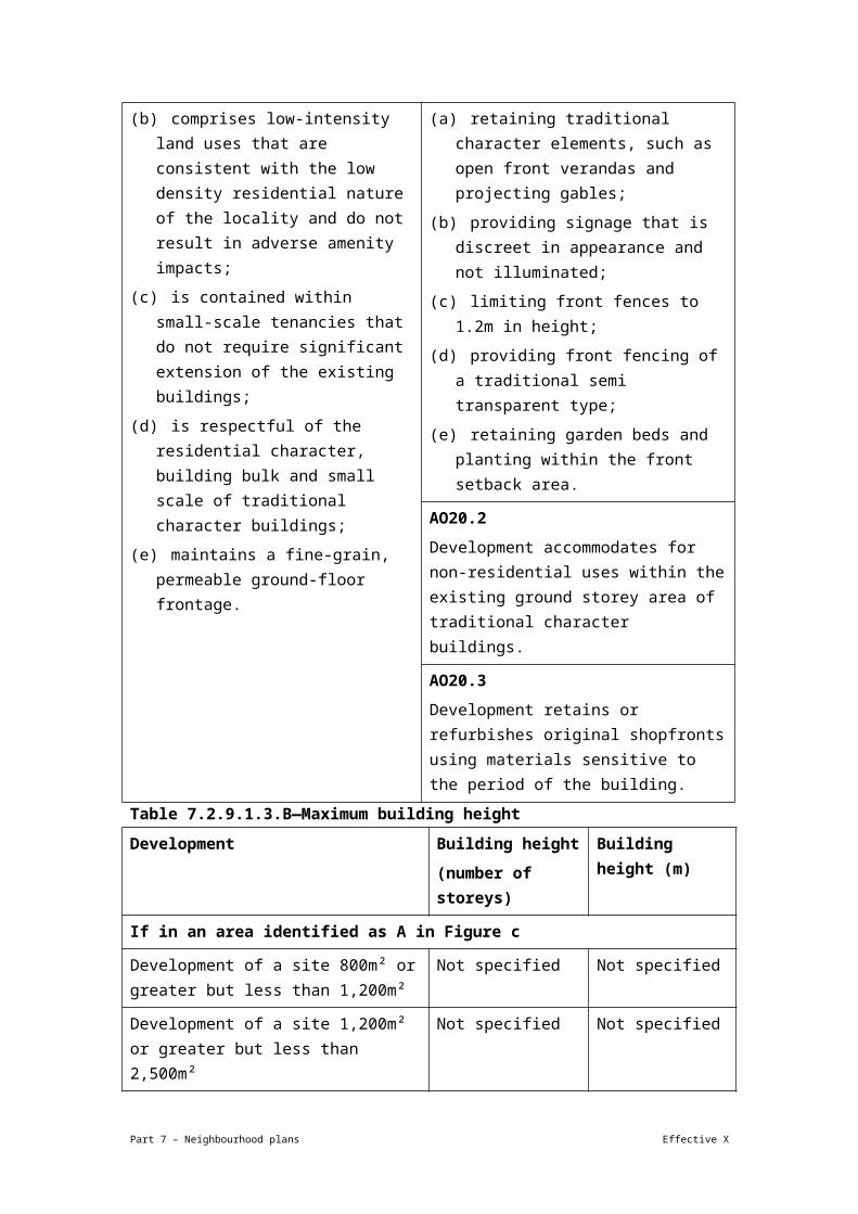
Development of a building for non-residential use:
(a) maintains the residential appearance of traditional character houses;
(b) comprises low-intensity land uses that are consistent with the low density residential nature of the locality and do not result in adverse amenity impacts;
(c) is contained within small-scale tenancies that do not require significant extension of the existing buildings;
(d) is respectful of the residential character, building bulk and small scale of traditional character buildings;
(e) maintains a fine-grain, permeable ground-floor frontage.
AO20.1
Development of a non-residential use in a traditional character house maintains a residential appearance by:
(a) retaining traditional character elements, such as open front verandas and projecting gables;
(b) providing signage that is discreet in appearance and not illuminated;
(c) limiting front fences to 1.2m in height;
(d) providing front fencing of a traditional semi transparent type;
(e) retaining garden beds and planting within the front setback area.
AO20.2
Development accommodates for non-residential uses within the existing ground storey area of traditional character buildings.
AO20.3
Development retains or refurbishes original shopfronts using materials sensitive to the period of the building.
Table 7.2.9.1.3.B—Maximum building height
Development Building height Building height (m)
Part 7 – Neighbourhood plans Effective X

(number of storeys)
If in an area identified as A in Figure c
Development of a site 800m² or greater but less than 1,200m²
Not specified Not specified
Development of a site 1,200m² or greater but less than 2,500m²
Not specified Not specified
Development of a site 2,500m² or greater but less than 4,000m²
20 Not specified
Development of a site 4,000m² or greater 20 Not specified
If in an area identified as B or B* in Figure c
Development of a site 800m² or greater but less than 1,200m²
6 Not specified
Development of a site 1,200m² or greater but less than 2,500m²
12 Not specified
Development of a site 2,500m² or greater but less than 4,000m²
15 Not specified
Development of a site 4,000m² or greater 20 Not specified
If in an area identified as C or C* in Figure c
Development of a site 800m² or greater but less than 1,200m²
6 Not specified
Development of a site 1,200m² or greater but less than 2,500m²
8 Not specified
Development of a site 2,500m² or greater but less than 4,000m²
10 Not specified
Development of a site 4,000m² or greater 15 Not specified
If in an area identified as D in Figure c
Development of a site less than 1,200m² 5 Not specified
Development of a site 1,200m² or greater but less than 2,500m²
5 Not specified
Development of a site 2,500m² or greater but less than 4,000m²
5 Not specified
Development of a site 4,000m² or greater Not specified Not specified
If in an area identified as E in Figure c
Any development 5 Not specified
If in an area identified as F in Figure c
Part 7 – Neighbourhood plans Effective X

Any development 4 Not specified
Note—Heights allowed on sites specified as B* in Figure c where complying with the minimum lot size.
Note—Heights allowed on sites specified as C* in Figure c where complying with the minimum lot size.
Table 7.2.9.1.3.C— Maximum gross floor area
Development Gross floor area
If in an area identified as A in Figure c
Development of a site 800m² or greater but less than 1,200m²
Not specified
Development of a site 1,200m² or greater but less than 2,500m²
Not specified
Development of a site 2,500m² or greater but less than 4,000m²
450% of the area of the site
Development of a site 4,000m² or greater 450% of the area of the site
If in an area identified as B or B* in Figure c
Development of a site 800m² or greater but less than 1,200m²
250% of the area of the site
Development of a site 1,200m² or greater but less than 2,500m²
300% of the area of the site
Development of a site 2,500m² or greater but less than 4,000m²
450% of the area of the site
Development of a site 4,000m² or greater 500% of the area of the site
If in an area identified as C or C* in Figure c
Development of a site 800m² or greater but less than 1,200m²
250% of the area of the site
Development of a site 1,200m² or greater but less than 2,500m²
250% of the area of the site
Development of a site 2,500m² or greater but less than 4,000m²
300% of the area of the site
Development of a site 4,000m² or greater 300% of the area of the site
If in an area identified as D in Figure c
Development of a site 800m² or greater but less than 1,200m²
150% of the area of the site
Development of a site 1,200m² or greater but less than 2,500m²
150% of the area of the site
Part 7 – Neighbourhood plans Effective X

Development of a site 2,500m² or greater but less than 4,000m²
200% of the area of the site
Development of a site 4,000m² or greater Not specified
If in an area identified as E in Figure c
Any development 150% of the area of the site (GFA) for all lot sizes
If in an area identified as F in Figure c
Any development 150% of the area of the site (GFA) for all lot sizes
Note—Gross floor area allowed on sites specified as B* in Figure c where complying with the minimum lot size.
Note—Gross floor area allowed on sites specified as C* in Figure c where complying with the minimum lot size.
Table 7.2.9.1.3.D—Minimum building setbacks
Development Storey
Ground–2nd floor 3rd–4th floor 5th floor and above
Front (m)
Side (m)
Rear (m)
Front (m)
Side (m)
Rear (m)
Front (m)
Side (m)
Rear (m)
Development of a site in the Major centre zone or the Mixed use zone fronting Moggill Road, Coonan Street, Lambert Road and Station Road using podium and tower typology
3 0 6 0 0 6 3 3 9
Development of a site in the Major centre zone or the Mixed use zone fronting all other streets and podium sleeve and tower typology
4 2 Not specified
4 2 Not specified
7 5 10
If in the Special context area precinct (Indooroopilly centre neighbourhood plan/NPP-003), where in the Jackson Street special context area sub-precinct (Indooroopilly centre neighbourhood plan/NPP-003a) or Moggill Road west special context area sub-precinct (Indooroopilly centre neighbourhood plan/NPP-003b)
Part 7 – Neighbourhood plans Effective X

Any development in these sub-precincts
Refer to PO16 and AO16, PO17 and AO17.1-AO17.3, PO18 and AO18, PO19 and AO19, PO20 and AO20.1-AO20.3 of this neighbourhood plan.
Note—Where development is located in a street that is subject to a road widening requirement, the alignment of the proposed widening is regarded as the street front property boundary.
Part 7 – Neighbourhood plans Effective X
View the high resolution of Figure a–Movement – Moggill Road north and Coonan Street north (PDF file size is 174Kb)
Part 7 – Neighbourhood plans Effective X

View the high resolution of Figure b–Public domain (PDF file size is 362Kb)
Part 7 – Neighbourhood plans Effective X

View the high resolution of Figure c–Building heights (PDF file size is 367Kb)
Part 7 – Neighbourhood plans Effective X

Part 7 – Neighbourhood plans Effective X

View the high resolution of Figure f–Movement – Coonan Street corridor (PDF file size is 155Kb)
Part 7 – Neighbourhood plans Effective X

Part 7 – Neighbourhood plans Effective X

Part 7 – Neighbourhood plans Effective X

7.2.9.2 Ithaca district neighbourhood plan code
7.2.9.2.1 Application
(1) This code applies to assessing a material change of use, reconfiguring a lot, operational work or building work in the Ithaca district neighbourhood plan area if:
(a) assessable development where this code is an applicable code identified in the assessment criteria column of a table of assessment for a neighbourhood plan (section 5.9); or
(b) impact assessable development.
(2) Land in the Ithaca district neighbourhood plan area is identified on the NPM-009.2 Ithaca district neighbourhood plan map and includes the following precincts:
(a) Butterfield Street precinct (Ithaca district neighbourhood plan/NPP-001):
(i) Butterfield Street a sub-precinct (Ithaca district neighbourhood plan/NPP-001a);
(ii) Butterfield Street b sub-precinct (Ithaca district neighbourhood plan/NPP-001b).
(b) Ballymore precinct (Ithaca district neighbourhood plan/NPP-002);
(c) Bishop Street precinct (Ithaca district neighbourhood plan/NPP-003);
(d) Guthrie Street precinct (Ithaca district neighbourhood plan/NPP-004);
(e) Brewery precinct (Ithaca district neighbourhood plan/NPP-005);
(f) Enoggera Terrace precinct (Ithaca district neighbourhood plan/NPP-006);
(g) Rosalie village precinct (Ithaca district neighbourhood plan/NPP-007);
(h) Hillside character precinct (Ithaca district neighbourhood plan/NPP-008).
(3) When using this code, reference should be made to section 1.5, section 5.3.2 and section 5.3.3.
Note—Hillside areas are steeper residential areas containing traditional character housing and significant ridgelines. Hillside character is derived from the relationship of buildings to their physical setting. Traditional character housing built following an historic subdivision pattern and located on well-treed hillsides results in a unique character of important visual significance in the local context.
Note—This neighbourhood plan includes a table of assessment with level of assessment variations to those in sections 5.5, 5.6, 5.7, 5.8 and 5.10. Refer to Table 5.9.31.A, Table 5.9.31.B, Table 5.9.31.C and Table 5.9.31.D.
Part 7 – Neighbourhood plans Effective X

7.2.9.2.2 Purpose
(1) The purpose of the Ithaca district neighbourhood plan code is to provide finer grained planning at a local level for the Ithaca district neighbourhood plan area.
(2) The purpose of the Ithaca district neighbourhood plan code will be achieved through overall outcomes of the neighbourhood plan area.
(3) The overall outcomes for the neighbourhood plan area are:
(a) Identified character housing and significant character streetscapes are maintained;
(b) A mix of housing densities and types serve the needs of the community;
(c) Hillside character is retained and enhanced through sympathetic development that minimises visual impact within its visual catchment;
(d) The ecological and recreational values of Ithaca and Enoggera creeks are protected;
(e) The neighbourhood plan area will capitalise on its strategic location by developing businesses and low impact industrial activities that support the City Centre and its fringe, or are associated with key facilities in the area, such as the Royal Brisbane and Women’s Hospital;
(f) Expansion of the hospital, medical school and research activities into the nearby residential areas is not consistent with the outcomes sought by the neighbourhood plan code;
(g) The industrial zoned land at Milton provides industrial support functions for the City Centre and its fringe;
(h) Business or retail activities on industrial zoned land at Milton are not consistent with the outcomes sought by the neighbourhood plan code unless they have a justifiable nexus with the surrounding industrial activities;
(i) Community facilities on privately owned land, including Ballymore and the Broncos Leagues Club, are protected to ensure the ongoing provision of a range of venues for the pursuit of sporting, recreational, community and cultural activities; Opportunities for new community facilities and services are encouraged.
(j) Significant views and vistas are to be protected;
(k) Development proposed in visually prominent locations such as major ridgelines and hilltops is designed to achieve minimal visual impact;
(l) Development forms that require cut and fill and disturbance of vegetation are not consistent with the outcomes sought by the neighbourhood plan code;
Part 7 – Neighbourhood plans Effective X
(m) Development is of a height, scale and form which is consistent with the amenity and character, community expectations and infrastructure assumptions intended for the relevant precinct, sub-precinct or site and is only developed at a greater height, scale and form where there is both a community need and an economic need for the development.
(4) Butterfield Street precinct (Ithaca district neighbourhood plan/NPP-001) overall outcomes are:
(a) Development enhances public access to Enoggera Creek and provides walking and cycling paths along the creek linking with Butterfield Street;
(b) Attractive pedestrian environments are provided along the Enoggera Creek with quality landscaping;
(c) Building envelopes are set back from the Enoggera Creek with elevations stepped towards Butterfield street;
(d) Development in the Butterfield Street a sub-precinct (Ithaca district sub-precinct neighbourhood plan/NPP-001a):
(i) supports non-residential uses that have a close nexus with the Royal Brisbane and Women’s Hospital complex provided relevant amenity and site flooding issues are satisfactorily addressed.
(e) Development in the Butterfield Street b sub-precinct (Ithaca district sub-precinct neighbourhood plan/NPP-001b):
(i) may compromise higher intensity mixed uses to co-exist with hospital uses provided relevant amenity and site flooding issues are satisfactorily addressed.
(5) Ballymore precinct (Ithaca district neighbourhood plan/NPP-002) overall outcomes are:
(a) Any alterations to the existing sporting facilities that result in an increase in capacity and/or intensity do not adversely affect the surrounding community;
(b) Further expansion of sporting facilities within the waterway corridor is minimised.
(6) Bishop Street precinct (Ithaca district neighbourhood plan/NPP-003) overall outcomes are:
(a) Bishop Street continues to provide an important industrial support function for the City Centre and its fringe;
(b) Business and commercial activities that do not have a direct link with the industrial precinct are not considered consistent with this outcome;
Part 7 – Neighbourhood plans Effective X

(c) Redevelopment of properties adjoining Enoggera Creek provides land for a park along the waterway corridor and contributes land for a walking and cycling link between Bishop Street and the creek.
(7) Guthrie Street precinct (Ithaca district neighbourhood plan/NPP-004) overall outcomes are:
(a) As the precinct is in proximity to Given Terrace and commercial and public transport facilities low–medium density residential uses are consistent with the outcomes sought;
(b) New development forms respectful relationships with its immediate neighbours and surrounding neighbourhood, consistent with its strategic location.
(8) Brewery precinct (Ithaca district neighbourhood plan/NPP-005) overall outcomes are:
(a) This precinct contains a purpose-built brewery of cultural heritage significance. The brewery is a Brisbane icon and a well-known landmark of the city, with a great physical presence within the locality. Any loss of the cultural heritage values of the site would be a significant iconic loss to the city and inconsistent with the outcomes sought in this precinct. As such, a range of associated subordinate cultural and tourism activities are encouraged to protect and enhance this value;
(b) The following range of subordinate cultural and tourism activities are consistent with the outcomes sought in the precinct:
(i) tourist attraction where tour centre and/or museum catering exclusively for cultural heritage associated with the brewery;
(ii) food and drink outlet where catering exclusively for tour centre and/or museum visitors or brewery employees;
(iii) shop retailing exclusively brewery products or memorabilia;
(iv) club for brewery employees.
(c) Medium impact industry uses where for brewery purposes is consistent with the outcomes sought for the precinct.
(9) Enoggera Terrace precinct (Ithaca district neighbourhood plan/NPP-006) overall outcomes are:
(a) Enoggera Terrace is maintained as an intact street containing a substantial range of early and historic buildings, the rarity of which contributes to the uniqueness of this precinct;
(b) Special area 1 – Musgrave Road, is a visually prominent site and represents a gateway into Enoggera Terrace. Development in special area 1 – Musgrave Road:
Part 7 – Neighbourhood plans Effective X

(i) addresses its corner location, its setting adjacent to a heritage place and its landmark value at the head of an historic street;
(ii) features centre activities that whilst limited in size and intensity, contribute to a locally prominent commercial node at this part of Enoggera Terrace;
(iii) employs quality contemporary architecture respectful of its setting and context rather than replicative design;
(iv) features low rise mixed uses incorporating multiple dwellings and a small component of centre activities at a scale consistent with the outcomes sought for this special area.
(c) Special area 2 – Skate Arena, contains a purpose-built theatre of cultural heritage significance, which has great physical presence within the locality. Development in Special area 2 – Skate Arena:
(i) retains the site’s cultural heritage and landmark value;
(ii) comprises an adaptive re-use featuring quality contemporary architecture respectful of its setting and context rather than replicative design;
(iii) contains multiple dwellings within the existing building footprint at a scale consistent with the outcomes sought for this special area;
(iv) retains the Enoggera Terrace facade.
(d) Given the lack of on-street parking and the preference for site access from Mannion Street rather than Enoggera Terrace, high traffic-generating uses are not consistent with the outcomes sought for special areas 2 and 3;
(e) Special area 3 – 78 Enoggera Terrace, contains a church building that has been used successfully for a variety of activities since its original purpose was discontinued. Despite the small allotment size, adaptive re-use of the existing structure for small-scale non-residential uses or a multiple dwellings is consistent with the outcomes sought in the special area.
(10) Rosalie village precinct (Ithaca district neighbourhood plan/NPP-007) overall outcome is:
(a) Given Rosalie village’s popularity as a food and drink outlet precinct, car parking bays other than those associated with an on-site residential use are to be made available for public use outside normal business hours. Any variation of parking requirements for a non-residential uses must be consistent with the outcomes sought in this precinct where available parking in perpetuity is achieved;
Part 7 – Neighbourhood plans Effective X

(b) In the event of the Rosalie Kindergarten ceasing operations, re-use of the existing structure for low impact centre activities may be appropriate. Relaxation of car parking requirements may be appropriate where the provision of parking would compromise the nature of the heritage place.
(11) Hillside character precinct (Ithaca district neighbourhood plan/NPP-008) overall outcomes are:
(a) Hillside character is maintained, retained and enhanced through sympathetic development that minimises visual impact within its visual catchment;
(b) Development along major ridgelines in the precinct contributes to a consistent rhythm and sense of scale along the ridgeline when viewed from the surrounding visual catchment;
(c) Residential development in particular, provides and/or incorporates:
(i) the appearance of traditional character houses uniformly spaced and stepped across well-treed hillsides;
(ii) compatible building height, bulk and proportions;
(iii) construction methods, such as posts or piers, that minimise the amount of alteration to site topography.
7.2.9.2.3 Assessment criteria
The following table identifies the assessment criteria for assessable development.
Table 7.2.9.2.3.A—Criteria for assessable development
Performance outcomes Acceptable outcomes
Building height
Part 7 – Neighbourhood plans Effective X
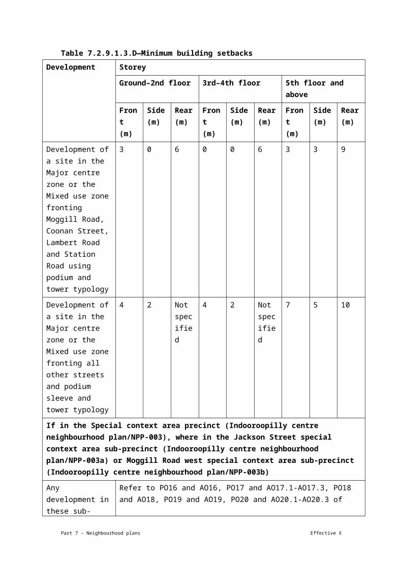
PO1
Development is of a height, scale and form that achieves the intended outcome for the precinct, improves the amenity of the neighbourhood plan area, contributes to a cohesive streetscape and built form character and is:
(a) consistent with the anticipated density and assumed infrastructure demand;
(b) aligned to community expectations about the number of storeys to be built;
(c) proportionate to and commensurate with the utility of the site area and frontage width;
(d) designed to avoid a significant and undue adverse amenity impact to adjoining development;
(e) sited to enable existing and future buildings to be well separated from each other and to avoid affecting the development potential of adjoining sites.
Note—Development that exceeds the intended number of storeys or building height can place disproportionate pressure on the transport network, public space or community facilities in particular.
Note—Development that is over-scaled for its site can result in an undesirable dominance of vehicle access, parking and manoeuvring areas that significantly reduce streetscape character and amenity.
AO1
Development complies with the number of storeys and building heights in Table 7.2.9.2.3.B.
Note—Neighbourhood plans will mostly specify a maximum number of storeys where zone outcomes have been varied in relation to building height. Some neighbourhood plans may also specify height in metres. Development must comply with both parameters where maximum number of storeys and height in metres are specified.
If in the Butterfield Street precinct (Ithaca district neighbourhood plan/NPP-001)
PO2
Development contributes toward the natural value of Enoggera Creek and the recreation needs of the local community by providing land for park purposes along Enoggera Creek that can accommodate a shared walking and cycling path and riparian rehabilitation.
AO2
Development ensures land within the waterway corridor or within 10m of the creek banks, whichever is greater for the purposes is dedicated to the Council.
PO3 AO3.1
Development in the Butterfield Street a sub-
Part 7 – Neighbourhood plans Effective X

Development provides emergency site access from any residential development during floods.
precinct (Ithaca district neighbourhood plan/NPP-001a) does not contain a residential component.
AO3.2
Development for residential purposes in the Butterfield Street b sub-precinct (Ithaca district neighbourhood plan/NPP-001b) achieves flood-free emergency access in a defined flood event to Butterfield Street.
PO4
Development preserves land adjoining Enoggera Creek for public use and buildings reinforce the creek corridor by providing:
(a) pedestrian links;
(b) high-quality, attractive building elevations that are orientated toward a corridor park;
(c) above-ground elevations and landscape treatments that are attractively designed to reduce tall blank areas to the corridor park and public cross-block pedestrian links.
AO4.1
Development on sites adjacent to Enoggera Creek provides a corridor park between the waterway corridor and the high water mark or 12m in width, whichever is greater.
AO4.2
Development provides a public walking and cycling path along the entire creek edge at no cost to the Council and designed in compliance with the Infrastructure Design planning scheme policy.
AO4.3
Development involving basement walls that face the landscaped public access ways to the corridor park incorporate a variety of landscaping and transitional elements for the entire length and width of the boundary setback.
AO4.4
Development ensures that building elevations orientated to the corridor park incorporate windows, parking areas or activity areas that overlook the corridor link park.
AO4.5
Development provides opportunities for passive surveillance over the corridor park and pedestrian links.
PO5
Development provides parking that achieves a balance between controlling congestion and providing sufficient short-
AO5
Development provides access, parking and servicing in accordance with the requirements of the Transport, access, parking and servicing
Part 7 – Neighbourhood plans Effective X
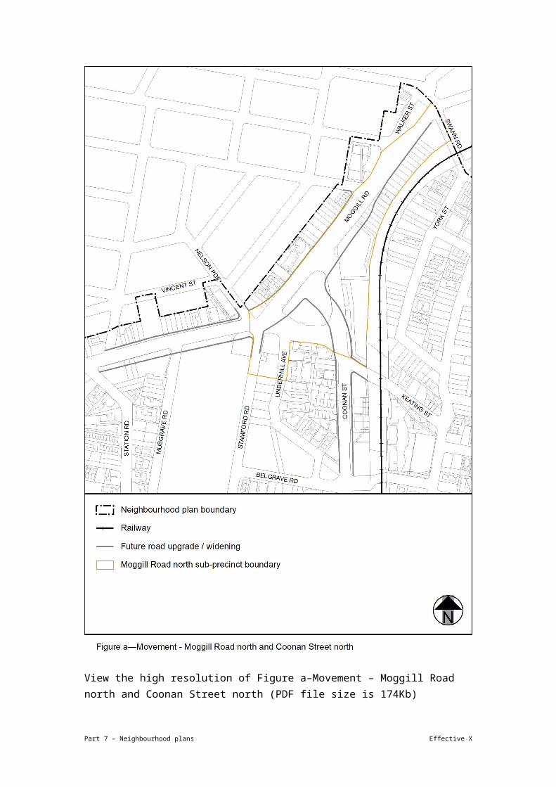
term parking to keep the anticipated commercial components of the precincts viable and service the needs of other users of the site’s facilities.
code, with the following exceptions:
(a) for residential development, the number of car parking spaces does not exceed 1.5 spaces per dwelling unit;
(b) the number of car parking spaces does not exceed 1 space per 30m² of gross floor area for non-residential uses.
If in the Butterfield Street precinct (Ithaca district neighbourhood plan/NPP-001), where in the Butterfield Street a sub-precinct (Ithaca district neighbourhood plan/NPP-001a)
PO6
Development maximises building setbacks to the corridor park and steps back building heights from the creek frontage.
AO6.1
Development has a maximum site cover of 75%.
AO6.2
Development has a maximum plot ratio of 150% of the site area.
AO6.3
Development has a maximum building height of 3 storeys and 10.5m.
AO6.4
Development of a building has a setback of 5m from the corridor park.
AO6.5
Development has a minimum front setback of 5m.
If in the Butterfield Street precinct (Ithaca district neighbourhood plan/NPP-001), where in the Butterfield Street b sub-precinct (Ithaca district neighbourhood plan/NPP-001b)
PO7
Development maximises building setbacks to the corridor park and steps back building heights from the creek frontage.
AO7.1
Development has a maximum site cover of 75%.
AO7.2
Development has a maximum plot ratio of 250% of the site area.
AO7.3
Development has a minimum front setback for basements of 2m.
AO7.4
Development has a minimum front setback above basement level of 8m.
Part 7 – Neighbourhood plans Effective X

AO7.5
Development may have front balconies protruding a maximum of 3m into the building setback.
If in the Ballymore precinct (Ithaca district neighbourhood plan/NPP-002)
PO8
Development contributes towards the natural value of Enoggera Creek and the recreation needs of the local community by providing land for park purposes along Enoggera Creek capable of accommodating a shared walking and cycling path and riparian rehabilitation.
AO8
Development ensures land within the waterway corridor or within 10m of the creek bank, whichever is greater, is dedicated to Council.
PO9
Development involving any substantial extensions to the existing sporting facility does not adversely impact on the surrounding residential community.
AO9
Development does not result in significant adverse community impacts that cannot be satisfactorily mitigated.
Note—This is demonstrated in a social health impact assessment report and management plan prepared in accordance with the Social and health impact assessment planning scheme policy and Consultation planning Scheme Policy.
PO10
Development of sites adjoining Enoggera Creek must provide a safe and convenient pedestrian and cyclist path between Bishop Street and Enoggera Creek and accommodate riparian rehabilitation.
AO10
A pedestrian/cyclist link is provided in accordance with the Bicycle network overlay code.
If in the Bishop Street precinct (Ithaca district neighbourhood plan/NPP-003)
PO11
Development of sites adjoining Enoggera Creek contributes to the natural value of the creek and the recreation needs of the local community.
AO11
Development on sites adjacent to Enoggera Creek provides a corridor park to be dedicated to the Council, comprising land within the waterway corridor or 8m from the top of the bank, whichever is greater.
PO12
Development of sites adjoining Enoggera Creek locates active on-site recreation areas so they overlook the adjoining park.
AO12
Development locates on-site recreation areas along the rear property boundary.
If in Special area 1 – Musgrave Road
Part 7 – Neighbourhood plans Effective X

PO13
Development ensures that building size, bulk and intensity of centre activities within the mixed use development is consistent with the locality and does not diminish the dominance of the adjacent heritage place.
AO13.1
Development has a maximum gross floor area of 75% the site area.
AO13.2
Development has a minimum of 65% of the total gross floor area which is used for residential purposes.
PO14
Development does not compromise the functions of the local road hierarchy.
AO14
Development does not provide vehicle access from Musgrave Road or Enoggera Terrace.
PO15
Development:
(a) contributes to a pedestrian-friendly commercial node on Enoggera Terrace;
(b) does not have parking that dominates street frontages.
AO15
Development is built to the Enoggera Terrace frontage and incorporates an awning over the footpath.
If in Special area 2 – Skate Arena
PO16
Development is consistent with the bulk and scale of the existing structure and conserves the cultural heritage values of the heritage place.
AO16.1
Development has a gross floor area that does not exceed the gross floor area of the existing structure.
AO16.2
Development is contained within the existing building envelope.
PO17
Development does not compromise the functions of the local road hierarchy.
AO17
Development does not provide vehicular access from Enoggera Terrace.
If in the Hillside character precinct (Ithaca district neighbourhood plan/NPP-008)
Development pattern and form
PO18
Development for residential purposes must be compatible with traditional character house scale and designed and sited to retain and reinforce the predominant development pattern and form of:
(a) separate allotments, whether or not the site area exceeds predominant lot sizes in the area or the site is an
AO18.1
Development has a building footprint, boundary setbacks and siting in relation to adjoining development that reflects the predominant development pattern and form of development in the area.
AO18.2
Development of buildings feature orthogonal plan forms with outside walls aligned to those
Part 7 – Neighbourhood plans Effective X

amalgamation of allotments;
(b) buildings of a traditional character house scale uniformly spaced and consistently stepped across well treed hillsides when viewed from the visual catchment;
(c) the design and scale of elevation and building form of the rear of extended or new buildings must consider the views of the building from surrounding areas, and the impact of the proposal on properties at the rear of the premises.
on adjoining allotments or within the development.
Building height, scale and proportions
PO19
Development for a residential purpose has a height, scale and proportions compatible with traditional character houses when viewed from the visual catchment.
AO19.1
Development of buildings are designed to appear as a series of separate blocks, each of a size and scale similar to that of a traditional character house, using either physical separation or:
(a) significant recesses and projections of the exterior wall plane;
(b) articulation through steps in the horizontal plane of the roof;
(c) roof geometry incorporating significant variety, such as pitched roofs of minimum 27.5o pitch;
(d) elevational and roof treatment using a variety of materials, colours and finishes compatible with traditional character houses to achieve the appearance of separate blocks;
(e) landscaped areas to achieve the appearance of separate blocks, and include trees capable of deep planting and growing to roof height.
AO19.2
Development has building heights exceeding the prescribed acceptable outcome only where:
(a) use of traditional character elements or
Part 7 – Neighbourhood plans Effective X

site responsive construction methods has resulted in non-compliance with the prescribed acceptable outcome;
(b) any additional building height or storeys are incorporated into a building form appearing to comply with the prescribed acceptable outcome, such as outcomes where 2-storey development is prescribed and a third storey is incorporated into a roof space area.
Note—Site-responsive construction methods, such as posts or piers, minimise the amount of alteration to site topography. Traditional character elements are pitched roofs of a minimum 27.5 o pitch.
AO19.3
Development has a site cover exceeding the prescribed acceptable outcome only where the development is designed to reduce building bulk in accordance with AO19.1.
AO19.4
Development has eaves heights that reflect the predominant development pattern and form of development in the area:
(a) along undulating ridgelines;
(b) horizontally across hillsides;
(c) vertically down hillsides.
AO19.5
Development does not have a uniform elevational treatment above ground level without variation, articulation or openings longer than 10m.
PO20
Development must be designed, sited and landscaped to minimise the impact of incompatible building bulk, maintain and enhance the traditional character and built form of this precinct in terms of building:
(a) bulk, form and scale;
(b) eaves heights;
(c) elevational treatment;
(d) construction materials;
AO20
No acceptable outcome is prescribed.
Part 7 – Neighbourhood plans Effective X
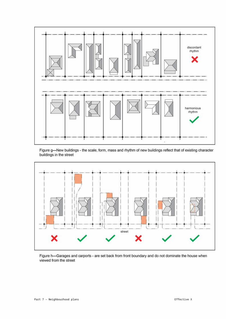
(e) by using quality contemporary architecture respectful of its setting;
(f) development along ridgelines must not dominate the skyline and must be designed and sited to contribute to a consistent rhythm and sense of scale along the ridgeline when viewed from the visual catchment.
PO21
Development along ridgelines does not dominate the skyline and is designed and sited to contribute to a consistent rhythm and sense of scale along the ridgeline when viewed from the visual catchment.
AO21
No acceptable outcome is prescribed.
Landscape character, physical setting and topography
PO22
Development minimises impacts to existing significant vegetation and provide replacement vegetation on the site of advanced size and maturity where significant vegetation is removed.
AO22
Development:
(a) designs and sites buildings or other structures, driveways and hard-stand areas to maximise the retention of vegetation on the site;
(b) replaces significant vegetation removed as a result of the development with vegetation of advanced size and maturity that contributes to the special character of the area.
Note–Trees featuring a trunk diameter width of 250mm or greater measured at 1m above ground level are considered significant vegetation. Advanced size and maturity is vegetation of 100L minimum stock size planted in sufficient quantity to achieve a total canopy area of 50% of the removed vegetation when mature.
PO23
Development must be designed and sited to retain or reinforce the landscape character and physical setting of the locality, and to break up building bulk and buildings must appear to be uniformly sited on well–treed hillsides and consistently spaced along major ridgelines.
AO23.1
Development provides communal open space and ground storey private open space required for residential development is provided at a minimum dimension of 5m.
AO23.2
Development ensures that boundary setbacks are a minimum of:
(a) 6m to the rear boundary;
(b) 12m to the rear boundary on sites steeper
Part 7 – Neighbourhood plans Effective X

than 1 in 8 gradient (long axis from the front boundary to rear boundary of the site);
(c) 6m to any adjoining site’s front or rear boundary in the case of rear allotments.
AO23.3
Development comprising a carport, car parking space or other structures associated with a multiple dwelling is not located in the setback area.
Note—In the case of corner lots, the rear boundary is that boundary which abuts other rear boundaries.
PO24
Development, including buildings or other structures, driveways and hard-stand areas, must be designed and sited to minimise cut-and-fill disturbance on the site and to soften visual impact.
AO24.1
Development incorporates:
(a) foundation systems that minimise disturbance to the landscape, such as post-and-pier type foundations;
(b) slab-on-ground foundations only on those parts of a site with gradients less than 1 in 8 and where cut and fill is minimal;
(c) benching, cut and fill, or construction of retaining walls of a minor nature only (i.e. fill does not exceed 1m and/or the combined height of any retaining wall and fence does not exceed 2m) and is designed so it is not noticeable after construction has been completed;
(d) driveways and hard-stand areas only on those parts of a site with gradients less than 1 in 4.
AO24.2
Development provides retaining walls that are set back from any boundary and are stepped, terraced and landscaped.
Public domain
PO25
Development provides long term infrastructure for the land for community facilities network to meet the recreational needs of residents and workers
AO25
Development protects land for community facilities in the general location specified in Figure b and in accordance with the Long term infrastructure plan
Part 7 – Neighbourhood plans Effective X

Table 7.2.9.2.3.B—Maximum building height
Precinct/sub-precinct Building height
(number of storeys)
Building height (m)
If in the Butterfield Street a sub-precinct (Ithaca district neighbourhood plan/NPP-001a)
Any development in this precinct 3 10.5
If in the Butterfield Street b sub-precinct (Ithaca district neighbourhood plan/NPP-001b)
Any development in this precinct 10 Not specified
If in the Enoggera Terrace precinct (Ithaca district neighbourhood plan/NPP-006), where in the Special area 1 – Musgrave Road
Any development in this precinct 2 9.5
If in the Hillside character precinct (Ithaca district neighbourhood plan/NPP-008)
Any development in this precinct 2 9.5
Part 7 – Neighbourhood plans Effective X

View the high resolution of Figure a–Special areas (PDF file size is 158Kb)
Part 7 – Neighbourhood plans Effective X

View the high resolution of Figure b–Public domain (PDF file size is 158Kb)
Part 7 – Neighbourhood plans Effective X
7.2.19.4 South Brisbane riverside neighbourhood plan code
7.2.19.4.1 Application
(1) This code applies to assessing a material change of use, reconfiguring a lot, operational work or building work in the South Brisbane riverside neighbourhood plan map area if:
(a) assessable development where this code is an applicable code identified in the assessment criteria column of a table of assessment for a neighbourhood plan (section 5.6); or
(b) impact assessable development.
(2) Land in the South Brisbane riverside neighbourhood plan area is identified on the NPM-019.4 South Brisbane riverside neighbourhood plan map and includes the following precincts:
(a) South Brisbane reach precinct (South Brisbane riverside neighbourhood plan/NPP-001);
(b) Musgrave precinct (South Brisbane riverside neighbourhood plan/NPP-002);
(c) Boundary and Vulture precinct (South Brisbane riverside neighbourhood plan/NPP-003):
(i) Village heart sub-precinct (South Brisbane riverside neighbourhood plan/NPP-003a).
(d) Kurilpa precinct (South Brisbane riverside neighbourhood plan/NPP-004):
(ii) Kurilpa south sub-precinct (South Brisbane riverside neighbourhood plan/NPP-004a);
(iii) Kurilpa north sub-precinct (South Brisbane riverside neighbourhood plan/NPP-004b).
(e) Riverside north precinct (South Brisbane riverside neighbourhood plan/NPP-005);
(f) Buchanan and Davies parks precinct (South Brisbane riverside neighbourhood plan/NPP-006):
(i) Hockings Street sub-precinct (South Brisbane riverside neighbourhood plan/NPP-006a).
(g) Riverside south precinct (South Brisbane riverside neighbourhood plan/NPP-007).
Editor's note—Part of the neighbourhood plan area is covered by the South Bank Corporation area which South Bank Corporation is responsible for planning under the South Bank Corporation Act 1989.
Part 7 – Neighbourhood plans Effective X

(3) When using this code, reference should be made to section 1.5, section 5.3.2 and section 5.3.3.
Note—This neighbourhood plan includes a table of assessment with level of assessment variations to those in sections 5.5, 5.7, 5.8, 5.9 and 5.10. Refer to Table 5.9.63.A, Table 5.9.63.B, Table 5.9.63.C and Table 5.9.63.D.
7.2.19.4.2 Purpose
(1) The purpose of the South Brisbane riverside neighbourhood plan code is to provide finer grained planning at a local level for the South Brisbane riverside neighbourhood plan area.
(2) The purpose of the South Brisbane riverside neighbourhood plan code will be achieved through overall outcomes including overall outcomes for each precinct of the neighbourhood plan area.
(3) The overall outcomes for the neighbourhood plan area are:
(a) South Brisbane riverside is an eclectic, inner-city riverside community, supporting an established, diverse and growing local population situated within a key emerging employment locality and cultural district of international reputation.
(b) The community’s creative focus and relaxed way of life will be reflected through high-quality buildings and public realm, incorporating subtropical design excellence and innovation.
(c) Development is of a height, scale and form which is consistent with the amenity and character, community expectations and infrastructure assumptions intended for the relevant precinct, sub-precinct or site and is only developed at a greater height, scale or site and is only developed at a greater height, scale and form where there is both a community need and an economic need for the development.
(d) Development makes a positive contribution to the public realm through on-site amenity such as deep planting, well-connected and publicly accessible spaces, protection of existing vegetation, landscaping and public art.
(e) Development along the river’s edge enhances the Kurilpa Point Park, South Brisbane Riverside Lands Park and the West End Riverside Lands Park, by providing improved access, appropriate building setback, bulk and separation, materials, design and landscaping.
(f) New social facilities and infrastructure are provided to support the needs created by increased residential and employment densities.
(g) Structure planning of key development sites achieves integration with their surrounds, creation of attractive public realm and retention and re-use of on-site heritage structures.
Part 7 – Neighbourhood plans Effective X

(h) Important character values are retained and enhanced by maintaining key views and vistas to the Brisbane River and Taylor Ranges.
(4) South Brisbane reach precinct (South Brisbane riverside neighbourhood plan/NPP-001) overall outcomes are:
(a) This precinct is a gateway to the South Brisbane riverside area and contains some of Brisbane's key destinations, such as the ‘cultural precinct’, the South Bank ‘entertainment precinct’ and ‘educational precinct’.
(b) A further focus of this precinct is its public realm, with buildings set along boulevards and in parkland. New and enhanced public spaces serve a variety of purposes suited to their location, including river boardwalk access or views, informal gathering and meeting places or formal plazas. Public realm improvements also occur through upgrades along Tribune Street, Ernest Street, Glenelg Street and parts of Melbourne Street.
(c) Connectivity with the Brisbane River is enhanced through improvements to the link under the Brisbane Convention and Exhibition Centre, connecting the heart of West End with South Bank. The future development of the South Bank rail and busway stations delivers high-quality intermodal public transport facilities, integrating new public spaces with excellent urban amenity and improved pedestrian links.
(5) Musgrave precinct (South Brisbane riverside neighbourhood plan/NPP-002) overall outcomes are:
(a) This precinct provides for a mix of activities and uses, including high-density residential and offices with ground-storey retail. Key worker and student accommodation is encouraged.
(b) Options to upgrade Russell Street will be explored to improve pedestrian and cyclist safety and movement from Boundary Street to South Bank. On-site landscaping will increase the visual greenery and amenity of the area.
(c) Active elements of new mixed use development along Russell Street, Cordelia Street and Edmondstone Street will overlook the streets and park to improve pedestrian safety.
(6) Boundary and Vulture precinct (South Brisbane riverside neighbourhood plan/NPP-003) overall outcomes are:
(a) This precinct is the heart of South Brisbane riverside. Boundary Street has a retail, food and drink outlet, entertainment and community focus and maintains a human scale built form at the street level.
(b) Development between Russell Street, Vulture Street, O’Connell Street and Edmondstone Street accommodates a broad range of medium-density residential units, small-scale ground storey retail and small-scale commercial uses. Residential
Part 7 – Neighbourhood plans Effective X

accommodation provides opportunities for a diverse population including families, students, and key workers. Compatible community and educational uses, such as a child care centre and retirement facility, are interspersed amidst medium-density residential units.
(c) Mixed use development along Boundary, Russell and Vulture streets creates a pleasant pedestrian experience through active frontages, awnings and streetscape improvements. Particular attention is given to increasing landscaping, greenery and shade along Vulture Street. Dwelling units are located above ground-storey retail and commercial uses to maximise day/night casual surveillance of these key pedestrian and bicycle routes.
(d) Redevelopment of the Absoe site (111 Boundary Street – Lot 2 on RP151557) contributes to the vibrant village atmosphere of Boundary Street. A new urban plaza or public space on Boundary Street links activity from Boundary Street through the site to Mollison Street where the proposed CityGlider station is located. Retaining and re-using heritage buildings on the Absoe site gives new life to old buildings. Mixed use development integrates active ground-storey uses and community spaces with residential and commercial uses. New roads and pedestrian links allow people to move between Mollison, Little Jane and Wilson streets. Pressure on local parking is relieved by inclusion of an underground commercial car park forming part of the integrated redevelopment of the Absoe site.
(e) Development in the Village heart sub-precinct (South Brisbane riverside neighbourhood plan/NPP-003a):
(i) supports low- to mid-rise development.
(7) Kurilpa precinct (South Brisbane riverside neighbourhood plan/NPP-004) overall outcomes are:
(a) This precinct provides for high-density mixed-use development, supporting the core function of the CBD. A high-quality public realm consisting of open spaces and enhanced streets contributes to South Brisbane riverside becoming a ‘world class cultural district’ with day and night-time activity.
(b) Permanent and short-term accommodation is provided where residential amenity is highest or within mixed use buildings.
(c) Streetscape improvements and pedestrian links increase pedestrian and cyclist movement through the precinct and to the surrounding river crossings.
(d) Fish Lane is a vibrant active laneway with small retail tenancies.
(e) Hope Street is a destination for dining, entertainment and retail in combination with public space under the rail viaduct and will link Melbourne Street to the redevelopment on the Parmalat site between Montague Road and the river.
Part 7 – Neighbourhood plans Effective X

(f) The Parmalat site is redeveloped into a mixed use landmark for Brisbane with high-quality public space and enhanced connections to the river.
(g) Development in the Kurilpa south sub-precinct (South Brisbane riverside neighbourhood plan/NPP-004a):
(i) supports medium- to high-density development.
(h) Development in the Kurilpa north sub-precinct (South Brisbane riverside neighbourhood plan/NPP-004b):
(i) supports high-density development.
(8) Riverside north precinct (South Brisbane riverside neighbourhood plan/NPP-005) overall outcomes are:
(a) This precinct is a transition zone between the high-density development of the Kurilpa precinct to the north, and lower density buildings to the south. Residential apartments take advantage of parkland and riverfront amenity, set amongst landscaping and new public spaces.
(b) Redevelopment of the Australian Consolidated Industries and Hanson sites creates a new vibrant destination with significant community benefit. Brereton Street will be extended to the river and contain residential, commercial, retail, cultural and community uses. New public spaces will be created together with new connections to the river and its parklands. Heritage buildings will be retained and adapted for new uses. Until redevelopment occurs, the continued and viable operation of the Australian Consolidated Industries and Hanson industries is enabled and residential uses are not located adjacent to industrial development that generates noise or with long operating hours. Commercial uses that are designed to allow for long-term adaptation into residential uses are appropriate.
(c) Along Montague Road, predominantly commercial and retail development, street upgrades, landscaping and building design provides an attractive and comfortable environment for pedestrians.
(d) Mollison Street and Hocking Street are upgraded to create attractive and comfortable pedestrian environments between the riverside and the heart of West End.
(9) Buchanan and Davies parks precinct (South Brisbane riverside neighbourhood plan/NPP-006) overall outcomes are:
(a) This precinct is a vibrant mixed use area, with residential uses predominantly focused towards the river and Bank Street.
(b) A wide variety of recreational activities and community facilities will be provided at Davies Park, catering for residents and employees in the precinct, and the wider South Brisbane riverside area.
Part 7 – Neighbourhood plans Effective X

(c) Along Hocking Street, Mollison Street, Jane Street and Montague Road, commercial and retail uses activate the area during the day, and may form part of mixed use developments with residential development above ground level. The current pattern of small lots and tenancies along Montague Road and Jane Street is maintained, with pedestrian amenity provided through awnings and landscaping.
(d) Development along Jane Street is mixed use to ensure casual surveillance over Davies Park is maintained day and night. Ground level uses tend towards arts and craft, cultural uses or health and wellbeing services.
(e) Development along Montague Road ranges in height, with taller buildings achievable on larger sites north of Vulture Street, consistent with built form along Montague Road to the north in the Kurilpa precinct (South Brisbane riverside neighbourhood plan/NPP-004) and the Riverside north precinct (South Brisbane riverside neighbourhood plan/NPP-005). Development frames the street, creating a continuous edge along Montague Road, softened by landscaping zones along the frontage.
(f) Laneways to the west and service lanes east of Montague Road access new development from internal streets. Increased building height is achieved on amalgamated lots, with access points to Montague Road reduced to improve the function of the road for the CityGlider, and pedestrian and cyclist movement. An additional vehicle connection between Hocking and Donkin streets accesses new buildings near the river, while allowing more internal movement away from Montague Road. A new connection to the South Brisbane Riverside Lands Park in the vicinity of Donkin Street increases access to the river. Until the Australian Consolidated Industries and Hanson sites are redeveloped, residential uses are not located on the opposite side of Hockings Street.
(g) On internal streets, buildings provide landscaping along the street frontage in a zone designed to deliver privacy to residences, while maintaining casual surveillance of the street and supplementing streetscaping. Existing trees are retained throughout the precinct, particularly in proximity to the South Brisbane Riverside Lands Park and on or adjacent to internal streets.
(10) Riverside south precinct (South Brisbane riverside neighbourhood plan/NPP-007) overall outcomes are:
(a) This precinct provides a transition between the ‘timber and tin’ housing of West End and Highgate Hill and new development in the South Brisbane riverside area. The precinct accommodates predominantly medium- to high-density residential development, which replaces obsolete industrial and warehouse uses. Small-scale retail and commercial uses integrated within new residential developments, servicing the local community, are consistent with the outcomes sought. This precinct allows for a retail component with a maximum gross floor area of
Part 7 – Neighbourhood plans Effective X

4,000m² and primary frontage to Montague Road to be located between Ferry Road and Davies Park.
(b) A new ferry terminal is located at Victoria Street and associated land uses are supported to activate the terminal.
(c) Wide industrial streets are transformed into residential streets with narrower carriageways and room for pedestrians and cyclists. Parks and pedestrian connections provide additional open space and pedestrian and cycle only access to West End Riverside Lands Park. Redevelopment adjacent to Davies Park enhances the park interface and improves casual surveillance.
(d) Redevelopment of sites at the end of Duncan Street and Bailey Street will provide a new connection from Montague Road to West End Riverside Lands Park as an extension of Rogers Street. Other connections parallel to Montague Road through old industrial sites complete the road network so that local traffic can move internally rather than on Montague Road and people can move more easily around the area.
(e) Development provides a range of dwelling sizes and types. Buildings on large sites with taller towers located towards the centre of the site to minimise off-site impacts such as overlooking and overshadowing.
(f) Mixed use development along Montague Road activates the street during the day with small retail or commercial tenancies, and residential uses above. Where possible, these premises are accessed by vehicles from rear lanes such as Tondara lane or Wolfe Street.
(g) Development along the eastern side of Montague Road and the northern side of Forbes Street is sensitive to adjoining residences outside of the South Brisbane riverside area, by using layout and architectural treatments to minimise impacts.
7.2.19.4.3 Assessment criteria
The following table identifies the assessment criteria for assessable development.
Table 7.2.19.4.3.A—Criteria for assessable development
Performance outcomes Acceptable outcomes
For assessable development
Built form
PO1
Development is of a height, scale and form that achieves the intended outcome for the precinct, improves the amenity of the neighbourhood plan area, contributes to a cohesive streetscape and built form
AO1.1
Development complies with the number of storeys and building height in Table 7.2.19.4.3.B.
Note—Neighbourhood plans will mostly specify a maximum number of storeys where zone outcomes have been varied
Part 7 – Neighbourhood plans Effective X

character and is:
(a) consistent with anticipated density and assumed infrastructure demand;
(b) aligned to community expectations about the number of storeys to be built;
(c) proportionate to and commensurate with the utility of the site area and frontage width;
(d) designed to avoid a significant and undue adverse amenity impact to adjoining development;
(e) sited to enable existing and future buildings to be well separated from each other and to avoid affecting the potential development of an adjoining site.
Note—Development that exceeds the intended number of storeys or building height can place disproportionate pressure on the transport network, public space or community facilities in particular.
Note—Development that is over-scaled for its site can result in an undesirable dominance of vehicle access, parking and manoeuvring areas that significantly reduce streetscape character and amenity.
in relation to the building height. Some neighbourhood plans may also specify height in metres. Development must comply with both parameters where maximum number of storeys and the height in metres are specified.
AO1.2
Development, except where located in the Kurilpa precinct (South Brisbane riverside neighbourhood plan/NPP-004) and Riverside south precinct (South Brisbane riverside neighbourhood plan/NPP-007), can have buildings on corner sites identified in Figure b with an additional 2 storeys of height than that shown in Table 7.2.19.4.3.B, provided additional storeys are restricted in scale to a maximum horizontal dimension of 30m.
AO1.3
Development has a maximum site cover in accordance with Table 7.2.19.4.3.C.
PO2
Development ensures that building placement and bulk maintains significant views and vistas towards the ridgeline of the Taylor Ranges as obtained from the locations identified in Figure a.
Note—A view analysis is to be prepared that demonstrates compliance with this performance outcome and a 3D model of the proposal is to be provided to assist in the Council’s assessment of an application.
AO2
No acceptable outcome is prescribed.
PO3
Development of buildings over 8 storeys are made up of a podium and clearly defined slender tower to reduce visual bulk and scale. Spacing between multiple towers provides for solar access, cross ventilation and privacy.
AO3.1
Development ensures that the tower elements of new buildings extend no more than 75% of the width of the podium.
AO3.2
Development has a maximum horizontal dimension for a tower of 40m on any side.
Part 7 – Neighbourhood plans Effective X

AO3.3
Development on a site greater than 3,000m² provides more than 1 tower and a minimum separation distance of 10m between the towers.
PO4
Development provides building setbacks that are sufficient to ensure that the building:
(a) protects important views and vistas identified in Figure a;
(b) does not dominate the street or other pedestrian spaces;
(c) does not prejudice the development of adjoining sites;
(d) enables existing and future buildings to be well separated from each other to allow light penetration, air circulation, privacy and ensure windows are not built out by adjoining buildings;
(e) facilitates the creation of attractive, vibrant and accessible laneways.
AO4.1
Development provides buildings that are set back from the front property boundary as specified in Figure b.
AO4.2
Development provides buildings in the High density residential zone or Mixed use zone with a minimum setback from the side property boundary of 3m, or 5m where windows of habitable rooms face the side boundary.
AO4.3
Development of buildings where in a zone in the centre zones category that do not include a residential use:
(a) are built to the side boundary up to 4 storeys;
(b) where buildings are 8 storeys or less, upper storeys are set back from the side boundary by a minimum of 3m.
AO4.4
Development of a building including habitable rooms facing the side boundary where in a zone in the centre zones category has a building setback that is a minimum of 5m.
AO4.5
Development is set back from the rear property boundary of a minimum of 6m and uses the area for deep planting.
AO4.6
Development of a building on a site adjoining a laneway identified in Figure b does not require a building setback.
AO4.7
Part 7 – Neighbourhood plans Effective X

Development of a building that adjoins the West End Riverside Lands and South Brisbane Riverside Lands parks is set back a minimum of 6m from the property boundary.
AO4.8
Development of a building with tower elements is set back a minimum of 6m from the front of the podium and 5m from the side of the podium in the High density residential zone and the Medium density residential zone.
AO4.9
Development of a building with tower elements is set back a minimum of 4m from the front of the podium, 3m from the side of the podium and 4m from the rear of the podium or laneway where in a zone in the centre zones category.
Note—In a zone in the residential zones category, the setbacks within the relevant use code apply where alternatives are not specified in the neighbourhood plan.
Note—All front setbacks in a zone in the residential zones category are used for deep planting in accordance with Figure b.
PO5
Development provides podiums that are designed to provide a human-scale street environment and are consistent with the prevailing podium heights in the adjoining streetscape.
AO5.1
Development provides podiums that are built to the front property boundary and have a maximum height of 3 storeys, where located in the District zone precinct of the District centre zone.
AO5.2
Development provides podiums in all areas other than in the District zone precinct of the District centre zone, that are at least 2 storeys and no more than 4 storeys in height.
PO6
Development on a significant corner site provides a prominent visual reference and contribution to the neighbourhood’s public realm by:
AO6.1
Development, except where located in the Kurilpa precinct (South Brisbane riverside neighbourhood plan/NPP-004) and Riverside south precinct (South Brisbane
Part 7 – Neighbourhood plans Effective X
(a) accommodating high levels of pedestrian movement at the corner and enhancing the pedestrian experience;
(b) emphasising the corner setting through building form, expression, silhouette, scale, materials and landscaping;
(c) reinforcing a sense of arrival to the neighbourhood plan area, precinct or sub-precinct through marking a node, an intersection or connection point in the neighbourhood;
(d) respecting the prominence of any adjoining or nearby heritage places, traditional character buildings or local landmarks;
(e) where a land dedication is required:
(iii) accommodating a deep-planted large feature tree within the dedication area;
(iv) providing a building envelope that acknowledges and respects the presence of the large feature tree canopy.
riverside neighbourhood plan/NPP-007), can have buildings on significant corners in Figure b with an additional 2 storeys in addition to the number shown in Table 7.2.19.4.3.B, provided additional storeys are restricted in scale to a maximum horizontal dimension of 30m.
AO6.2
Development is designed to emphasise the corner setting and:
(a) provides building entries on both street frontages; or
(b) provides a single main entry at the corner.
AO6.3
Development provides an inverted corner land dedication in the locations indicated in Figure b.
Note—Refer to the Infrastructure design planning scheme policy.
AO6.4
Any part of the building including the basement but excluding awnings is kept outside the corner land dedication area.
PO7
Development provides buildings on riverfront sites that are designed to:
(a) maximise views and river breezes through the site from the river to the remainder of the precinct and surrounding residential areas;
(b) have a slender form when viewed from the river if a taller building;
(c) create a varied skyline using a range of building heights.
AO7.1
Development on a site fronting the South Brisbane Riverside Lands Park or West End Riverside Lands Park has a maximum building length of 30m in any direction.
AO7.2
Development that provides buildings that are located on a site fronting the South Brisbane Riverside Lands Park or West End Riverside Lands Park are orientated perpendicular to the river and are longer than they are wide.
AO7.3
Development, where more than 1 building is provided on a site fronting the South Brisbane Riverside Lands Park or West End
Part 7 – Neighbourhood plans Effective X

Riverside Lands Park, provides a minimum separation distance of 10m between buildings.
PO8
Development:
(a) is closely integrated with the street environment by providing built form and uses that activate the frontage and generate pedestrian traffic;
(b) for ground and podium levels abutting footpaths suits the nature and character of the street and provides:
(i) a gradual transition between public street and semi-public or private outdoor or building spaces;
(ii) a permeable edge to the street, which creates both a visual widening of the street section and amenable edge to pedestrian movement;
(iii) useable outdoor/semi-outdoor spaces that support outdoor lifestyles and engage with the public realm.
AO8.1
Development provides buildings of a built form that activate the ground and podium levels with windows and doors that allow for an active, visual connection and surveillance of streets, plazas and public spaces.
AO8.2
Development provides a building form that includes pedestrian entrances at least every 15–20m along the street frontages.
AO8.3
Development implements a transition at the street frontages as follows:
(a) subtropical boulevard, in accordance with Figure c;
(b) city streets, in accordance with Figure c, Figure d, Figure e or Figure f;
(c) neighbourhood streets, in accordance with Figure g.
Note—An outdoor room – soft landscape (Figure e) or a landscape transition (Figure c) are not suitable in the Village heart sub-precinct (South Brisbane riverside neighbourhood plan/NPP-003a).
AO8.4
Development ensures that the ground storey of buildings is occupied by uses that have visible presence on and interaction with the street such as shops, cafes, restaurants and offices at the following locations:
(a) Vulture Street;
(b) Boundary Street;
(c) Cordelia Street;
(d) Glenelg Street;
(e) Victoria Street;
(f) Montague Road
Part 7 – Neighbourhood plans Effective X

(g) Russell Street;
(h) Melbourne Street;
(i) Mollison Street;
(j) all buildings in the Kurilpa precinct (South Brisbane riverside neighbourhood plan/NPP-004).
Public realm
PO9
Development on a key development site makes a significant contribution to the public domain of South Brisbane riverside by supplementing existing public spaces.
AO9.1
Development provides new public open space as indicated in Figure a.
AO9.2
Development on a site where the area is equal to or greater than 10,000m² has a minimum of 20% of the site that is publicly accessible.
AO9.3
Development includes new open spaces or enhancement of existing open spaces which incorporates acceptable solutions identified in the Infrastructure design planning scheme policy.
PO9A
Development provides long term infrastructure for the land for community facilities network to meet the recreational needs of residents and workers.
AO9A
Development protects land for community facilities in the general location specified in Figure a and in accordance with the Long term infrastructure plan.
PO10
Development:
(a) creates an integrated and continuous through-block pedestrian network that facilitates logical and direct access to centres of activity, public transport facilities and small-scale spaces;
(b) creates new and enhances existing arcades, laneways and associated small-scale spaces;
(c) supports patronage of informal crossings and the safe movement of pedestrians across streets at ground level;
AO10.1
Development provides an arcade within an indicative location for an arcade identified in Figure a.
AO10.2
Development ensures that the design of new, or enhancement of existing, laneways and arcades:
(a) is in accordance with the specifications and acceptable outcomes identified in the Infrastructure design planning scheme policy;
(b) has a minimum corridor width as shown in Figure a:
Part 7 – Neighbourhood plans Effective X

(d) maintains arcades for public use during hours of operation.
(c) has a minimum unobstructed pedestrian path width of:
(i) 1.8m for arcades where in a zone in the residential zones category indicated to have a 5m width in Figure a;
(ii) 2m for arcades where in a zone in the residential zones category indicated to have a 6m width in Figure a;
(iii) 1.8m for arcades where in a zone in the centre zones category indicated to have a 3m width in Figure a;
(iv) 2.4m for arcades where in a zone in the centre zones category indicated to have a 5m width in Figure a;
(v) 2.4m for arcades where in a zone in the centre zones category indicated to have a 6m width in Figure a;
(d) implements a transition at the arcade frontage as follows:
(i) where in a zone in the centre zones category – Figure d and Figure e;
(ii) where in a zone in the residential zones category – Figure g.
Car parking, access and servicing
PO11
Development:
(a) provides buildings that are designed to accommodate useable floor space (not car parking) that genuinely activates and surveys the streetscape;
(b) designs and locates vehicle entrances, servicing and car parking to minimise disruption to building frontages and the pedestrian environment, and to reduce the visual impact on the street environment;
(c) maximises pedestrian movement, comfort and safety in areas of high pedestrian usage by reducing
AO11.1
Development provides car parking areas that are located underground.
AO11.2
Development provides vehicular access from a laneway or secondary frontages or where new service lanes can be created.
AO11.3
Development provides only 1 vehicle access point to each site.
Part 7 – Neighbourhood plans Effective X

pedestrian and vehicular conflict;
(d) has driveway crossovers that maintain the integrity, quality and primacy of footpaths;
(e) may incorporate above-ground parking only where sleeved by active facades.
If in the Boundary and Vulture precinct (South Brisbane riverside neighbourhood plan/NPP-003), the Riverside south precinct (South Brisbane riverside neighbourhood plan/NPP-007) or the Riverside north precinct (South Brisbane riverside neighbourhood/plan NPP-005)
PO12
Development on a site greater than 10,000m² provides towers that are designed and sited to ensure human-scale development at the street level and ameliorate amenity impacts on adjacent development.
AO12
Development provides buildings with a 10m setback between the tower and any street alignment.
If in the Kurilpa precinct (South Brisbane riverside neighbourhood plan/NPP-004)
PO13
Development of buildings adjacent to the Kurilpa Point Park and the South Brisbane Riverside Lands Park is:
(a) set in soft landscape or plaza areas and has a building layout to allow for maximum permeability and view windows to the Brisbane River;
(b) designed to reduce the impacts of solar access, wind and aspect on adjoining public spaces.
AO13
Development of buildings adjacent to Kurilpa Point Park or the South Brisbane Riverside Lands Park comprises a tower in a plaza setting.
PO14
Development is designed with podiums that are set back from the rear property boundary to ensure the development does not prejudice the development of adjoining sites and enables existing and future buildings to be separated to allow light penetration, air circulation, privacy and ensure windows are not built out by adjoining buildings.
AO14
Development is designed with podiums that are set back from the rear property boundary by a minimum of 4m for non-residential uses and 6m for residential uses.
PO15 AO15.1
Part 7 – Neighbourhood plans Effective X

Development:
(a) is closely integrated with the public space underneath the railway viaduct with built form and uses that activate the frontage, generate pedestrian traffic and provide a sense of human scale;
(b) incorporates building setbacks that create open, inviting and publicly accessible pedestrian spaces along the railway viaduct with open/plaza spaces linking the local street network to the railway viaduct public space;
(c) provides ground and podium levels adjacent to the railway viaduct public space that suit its nature and character and provide:
(i) activities that enliven and allow surveillance of the public space;
(ii) strong visual and physical connections between internal and external publicly accessible spaces;
(iii) a subtropical urban design and built form which will enhance the existing urban industrial infrastructure character of the railway viaduct;
(iv) a permeable edge between the public railway viaduct space and Merivale Street, Montague Road, Peel Street and Hope Street;
(v) useable outdoor/semi-outdoor spaces that support outdoor lifestyles and engage with the public realm;
(d) located below the railway viaduct is to be used for temporary activities only and is clear of permanent structures or any other activity that may impede construction and maintenance of railway infrastructure and emergency access.
Development designs the railway viaduct public space shown in Figure a and the buildings adjacent to the railway viaduct public space in accordance with the Infrastructure design planning scheme policy.
AO15.2
Development provides pedestrian entrances at least every 20m along the railway viaduct frontage.
AO15.3
Development provides buildings that are set back a minimum of 6m from the railway viaduct public space.
Part 7 – Neighbourhood plans Effective X

If in the Buchanan and Davies parks precinct (South Brisbane riverside neighbourhood plan/NPP-006), where in the High density residential zone
PO16
Development is designed with a tower that is sufficiently set back to ensure that the building does not dominate the street or other pedestrian spaces.
AO16.1
Development is designed with a podium fronting the street in accordance with Figure h.
AO16.2
Development is designed with podiums of at least 2 storeys and no greater than 4 storeys.
If in the Buchanan and Davies parks precinct (South Brisbane riverside neighbourhood plan/NPP-006), the Riverside north precinct (South Brisbane riverside neighbourhood plan/NPP-005) or the Riverside south precinct (South Brisbane riverside neighbourhood plan/NPP-007)
PO17
Development of buildings adjacent to the South Brisbane Riverside Lands Park or West End Riverside Lands Park does not provide private access to the parks.
AO17
Development on a site that adjoins the South Brisbane Riverside Lands Park or West End Riverside Lands Park provides access to the parks via a communal path network within the property boundary to connect existing public accessways to the parks.
If in the Riverside north precinct (South Brisbane riverside neighbourhood plan/NPP-005) or the Riverside south precinct (South Brisbane riverside neighbourhood plan/NPP-007)
PO18
Development of buildings adjacent to the South Brisbane Riverside Lands and West End Riverside Lands parks is set back to ensure that new development does not dominate the parks or other pedestrian spaces.
AO18
Development on a site that adjoins the South Brisbane Riverside Lands Park or West End Riverside Lands Park or new public open spaces has a maximum building height of 2 storeys for a distance of 20m from the common property boundary.
If in the Riverside South precinct (South Brisbane riverside neighbourhood plan/NPP-007)
PO19
Development provides corridor parks that:
(a) are pedestrian friendly, accessible green open spaces that link to the West End Riverside Lands Park;
(b) enhance views down to the river,
AO19.1
Development provides corridor parks and pedestrian connections in the locations identified in Figure a.
AO19.2
Part 7 – Neighbourhood plans Effective X

provide shade trees and seating, act as communal meeting spaces, are safe and accessible and incorporate public art works;
(c) complement the West End Riverside Lands Park open space network.
Development provides parks that:
(a) are designed in accordance with the Infrastructure design planning scheme policy and the West End Riverside Lands Park master plan;
(b) have a minimum corridor width of 12m where not within a road reserve (Beesley Street);
(c) are dedicated to the Council;
(d) may have a maximum of 1 communal pedestrian access point directly onto the corridor park;
(e) have no new driveways or vehicular access from development within corridor parks;
(f) provide for universal pedestrian access to West End Riverside Lands Park with integrated seating opportunities in ramp design.
If in the Boundary and Vulture precinct (South Brisbane riverside neighbourhood plan/NPP-003)
PO20
Development of a commercial car parking station on the Absoe site (‘car park site’ shown in Figure b) services the local business needs of surrounding retail uses.
AO20
Development of a commercial car parking station is provided in basement format and has capacity for approximately 450 car parks.
Table 7.2.19.4.3.B—Maximum building height
Development Building height (number of storeys)
If in the South Brisbane Reach precinct (South Brisbane riverside neighbourhood plan/NPP-001)
Not specified
If in the Musgrave precinct (South Brisbane riverside neighbourhood plan/NPP-002)
Development of a site less than 1,200m²
5
Development of a site 1,200m² or greater but less than 2,500m²
8
Development of a site 2,500m² or greater2
12
If in the Boundary and Vulture precinct (South Brisbane riverside neighbourhood
Part 7 – Neighbourhood plans Effective X

plan/NPP-003)
Development of a site less than 1,000m²
3
Development of a site 1,000m² or greater but less than 2,500m²
5
Development of a site 2,500m² or greater but less than 10,000m²
8
Development of a site 10,000m² or greater
15
If in the Boundary and Vulture precinct (South Brisbane riverside neighbourhood plan/NPP-003) and in the area bound by Edmondstone, Vulture, O’Connell and Russell streets
Development of a site 1,000m² or greater
6
Development of a site in the High density residential zone
6
If in the Boundary and Vulture precinct (South Brisbane riverside neighbourhood plan/NPP-003), where in the Village heart sub-precinct (South Brisbane riverside neighbourhood plan/NPP-003a)
Any development in this sub-precinct 3
If in the Kurilpa precinct (South Brisbane riverside neighbourhood plan/NPP-004)
Development of a site less than 1,000m²
10
Development of a site 1,000m² or greater or less than 1,800m²
20
Development of a site 1,800m² or greater
30
If in the Kurilpa precinct (South Brisbane riverside neighbourhood plan/NPP-004), where in the Kurilpa south sub-precinct (South Brisbane riverside neighbourhood plan/NPP-004a)
Development of a site less than 1,800m²
8
Development of a site 1,800m² or greater
12
If in the Kurilpa precinct (South Brisbane riverside neighbourhood plan/NPP-004), where in the Kurilpa north sub-precinct (South Brisbane riverside neighbourhood plan/NPP-004b)
Development of a site less than 5,000m²
15
Part 7 – Neighbourhood plans Effective X

Development of a site 5,000m² or greater
30
If in the Riverside north precinct (South Brisbane riverside neighbourhood plan/NPP-005)
Development of a site less than 1,800m²
12 except where fronting Montague Road where height is 5
Development of a site 1,800m² or greater
15 except where fronting Montague Road where height is 8
If in the Buchanan and Davies parks precinct (South Brisbane riverside neighbourhood plan/NPP-006)
Development of a site less than 1,800m²
8 where in the High density residential zone or 5 where in the Mixed use zone
Development of a site 1,800m² or greater
12 where in the High density residential zone or 8 where in the Mixed use zone
12 where in the Hockings Street sub-precinct (South Brisbane riverside neighbourhood plan/NPP-006a)
If in the Riverside south precinct (South Brisbane riverside neighbourhood plan/NPP-007) excluding land in the Low-medium density residential zone
Development of a site less than 500m² 4
Development of a site 500m² or greater but less than 10,000m²
7 where in a zone in the Residential zones category or 4 where in the Mixed use zone
Development of a site 10,000m² or greater
12 where in a zone in the Residential zones category or 6 where in the Mixed use zone
Note—Table 7.2.19.4.3.B does not apply to land in the Open space zone, Sport and recreation zone, or Character residential zone and in these areas heights are in accordance with the relevant city-wide codes.
Note—Significant corner sites identified in Figure b are allowed 2 storeys in addition to the heights specified in Table 7.2.19.4.3.B provided that the development complies with performance outcome PO6.
Table 7.2.19.4.3.C—Maximum site cover
Development Maximum site cover
If in the South Brisbane reach precinct (South Brisbane riverside neighbourhood plan/NPP-001)
Not specified
If in the Musgrave precinct (South Brisbane riverside neighbourhood plan/NPP-002)
70%
If in the Boundary and Vulture precinct (South Brisbane riverside
80%
Part 7 – Neighbourhood plans Effective X

neighbourhood plan/NPP-003), except where in the Character residential zone
If in the Kurilpa precinct (South Brisbane riverside neighbourhood plan/NPP-004)
80%
Note—On-site planning outcomes on key development sites are dependent on site planning outcomes subject to master planning (Parmalat).
If in the Riverside north precinct (South Brisbane riverside neighbourhood plan/NPP-005)
80% where in the Mixed use zone
Note—Dependent on site planning outcomes subject to master planning (Australian Consolidated Industries/Hanson).
If in the Buchanan and Davies parks precinct (South Brisbane riverside neighbourhood plan/NPP-006)
70% where in the Mixed use zone
60% where in the High density residential zone
If in the Riverside south precinct (South Brisbane riverside neighbourhood plan/NPP-007)
70% where in a zone in the Residential zones category
80% where in the Mixed use zone
Part 7 – Neighbourhood plans Effective X

View the high resolution of Figure a–New public open space, laneways, key development sites and significant views (PDF file size is 321Kb)
Part 7 – Neighbourhood plans Effective X

View the high resolution of Figure b–Front setbacks (PDF file size is 508Kb)
Part 7 – Neighbourhood plans Effective X

Part 7 – Neighbourhood plans Effective X

Part 7 – Neighbourhood plans Effective X

Part 7 – Neighbourhood plans Effective X

7.2.23.3 Western gateway neighbourhood plan code
7.2.23.3.1 Application
(1) This code applies to assessing a material change of use, reconfiguring a lot, operational work or building work in the Western gateway neighbourhood plan area if:
(a) assessable development where this code is an applicable code identified in the assessment criteria column of a table of assessment for a neighbourhood plan (section 5.9); or
(b) impact assessable development.
(2) Land in the Western gateway neighbourhood plan area is identified on the NPM-023.3 Western gateway neighbourhood plan map and includes the following precincts:
(a) Sumner precinct (Western gateway neighbourhood plans/NPP-001);
(b) Wacol institutional precinct (Western gateway neighbourhood plans/NPP-002);
(c) Wacol industrial precinct (Western gateway neighbourhood plans/NPP-003);
(d) Inala precinct (Western gateway neighbourhood plans/NPP-004);
(e) Carole Park/Ellen Grove precinct (Western gateway neighbourhood plans/NPP-005).
(3) When using this code, reference should be made to section 1.5, section 5.3.2 and section 5.3.3.
Note—This neighbourhood plan includes a table of assessment with level of assessment variations to those in sections 5.5, 5.6, 5.7, 5.8 and 5.10. Refer to Table 5.9.69.A, Table 5.9.69.B, Table 5.9.69.C and Table 5.9.69.D.
7.2.23.3.2 Purpose
(1) The purpose of the Western gateway neighbourhood plan code is to provide finer grained planning at a local level for the Western gateway neighbourhood plan area.
(2) The purpose of the Western gateway neighbourhood plan code will be achieved through overall outcomes including overall outcomes for each precinct of the neighbourhood plan area.
(3) The overall outcomes for the neighbourhood plan area are:
(a) The Western gateway district provides a base for major industrial development and accommodates a diverse residential community.
(b) The area exhibits well-integrated living, working and recreation areas and is supported by high-quality transport links, retail and commercial facilities.
Part 7 – Neighbourhood plans Effective X

(c) The Inala Civic Centre is to remain the major community and retail focus for the Western gateway area.
(d) New shopping facilities complement the services provided by the older centres.
(e) Major institutional uses in the Wacol institutional precinct (Western gateway neighbourhood plan/NPP-002) preserve areas of regional environmental significance and the rural character.
(f) Areas identified as subject to scenic constraints are recognised.
(g) An accessible network of green spaces focused on environment and waterway corridors, natural area corridors and desirable parkland is developed throughout the area. These green spaces contain valuable bushland areas and public parks, and offer a wide range of recreational opportunities.
(4) Sumner precinct (Western gateway neighbourhood plans/NPP-001) overall outcomes are:
(a) Industrial development remains the dominant form of development in this precinct.
(b) A green space link (desirable parkland, environment and waterway corridor) is established to correct the catchments of Jindalee Creek and Bullockhead Creek.
(5) Wacol institutional precinct (Western gateway neighbourhood plans/NPP-002) overall outcomes are:
(a) Future development within this area ensures the preservation of the area’s environmental and cultural significance.
(b) Areas of significant rural amenity, biodiversity and other open space values are to remain in their current state or be developed for low-intensity rural or open-space uses.
(c) Low impact industrial and commercial activities are to be consolidated around the intersection of Wacol Station Road and the Ipswich Motorway.
Note—This precinct is to contain a variety of significant government facilities. Primary responsibility for the management of these facilities and surrounding lands rests with a number of State Government agencies.
(6) Wacol industrial precinct (Western gateway neighbourhood plans/NPP-003) overall outcomes are:
(a) Showroom development in the vicinity of the intersection of Blunder Road and the Ipswich Motorway is consistent with the outcomes sought.
(7) Inala precinct (Western gateway neighbourhood plans/NPP-004) overall outcomes are:
Part 7 – Neighbourhood plans Effective X

(a) This precinct remains primarily a residential area supported by a range of retail, recreation and community facilities.
(b) Residential development is intensified around local centres and major open space areas.
(c) A variety of low–medium density residential housing types is consistent with the outcomes sought for this precinct.
(d) New residential areas east of Blunder Road are integrated with the existing urban area.
(e) Community activities are focused on the Inala Civic Centre, maintaining its role as the main retail and commercial focus for Inala and the surrounding suburbs.
(f) Mixed use development clustered around the Inala Civic Centre is consistent with the outcomes sought.
(g) Further residential development east of Blunder Road in close proximity to the Inala Waste Water Treatment Plant is not compatible while it is in operation.
(8) Carole Park/Ellen Grove precinct (Western gateway neighbourhood plans/NPP-005) overall outcomes are:
(a) Carole Park is to remain predominantly a residential area.
(b) Initiatives to broaden the range of housing forms and to reduce the concentration of public housing in Carole Park are consistent with the outcomes sought for the precinct.
(c) Development in Ellen Grove supports significant biodiversity values (as shown on the Biodiversity areas overlay). Development within the precinct must be sensitively located, designed and constructed to minimise adverse impacts on these biodiversity values.
7.2.23.3.3 Assessment criteria
The following table identifies the assessment the criteria for assessable development.
Table 7.2.23.3.3—criteria for assessable development
Performance outcomes Acceptable outcomes
If in the Sumner precinct (Western gateway neighbourhood plan/NPP-001)
PO1
Development contributes to open space corridors connecting the Jindalee Creek and Bullock Head Creek catchments.
AO1
Development provides an open space corridor along the eastern and southern boundaries of the former QCL site to connect under the Centenary Highway. The indicative width of this corridor is 20m.
Part 7 – Neighbourhood plans Effective X

Hydraulic, ecological and visual landscape investigations may be required to determine the appropriate width in a particular location.
If in the Wacol institutional precinct (Western gateway neighbourhood plan/NPP-002)
PO2
Development, particularly for government facilities, must proceed according to an approved structure plan.
AO2
Development in areas of regional environmental and scenic significance are:
(a) retained in public ownership and designated as parkland or reserves;
(b) linked by habitat areas and ecological corridors and are not required to be publicly accessible.
PO3
Development provides for a publicly accessible corridor along the Brisbane River.
AO3
Development provides the publicly accessible corridor at an indicative width of 120m from the top of the Brisbane River high bank. Hydraulic, ecological and visual landscape investigations may be required to determine the approximate width in a particular location.
Site design should prevent adjoining proposals from having a detrimental effect on the visual landscape of these lands.
Public domain
PO4
Development provides long term infrastructure for the land for community facilities network to meet the recreational needs of residents and workers.
AO4
Development protects land for community facilities in the general location specified in Figure b and in accordance with the Long term infrastructure plan.
Part 7 – Neighbourhood plans Effective X
View the high resolution of Figure a–Western gateway (PDF file size is 122Kb)
Part 7 – Neighbourhood plans Effective X

View the high resolution of Figure b– Public domain (PDF file size is 122Kb)
Part 7 – Neighbourhood plans Effective X

7.2.23.6 Wynnum—Manly neighbourhood plan code
7.2.23.6.1 Application
(1) This code applies to assessing a material change of use, reconfiguring a lot, operational work or building work in the Wynnum—Manly neighbourhood plan area if:
(a) assessable development where this code is an applicable code identified in the assessment criteria column of a table of assessment for a neighbourhood plan (section 5.9); or
(b) impact assessable development.
(2) Land within the Wynnum—Manly neighbourhood plan area is identified on the NPM-023.6 Wynnum—Manly neighbourhood plan map and includes the following precincts:
(a) Wynnum north precinct (Wynnum—Manly neighbourhood plan/NPP-001):
(i) Wynnum north sub-precinct (Wynnum—Manly neighbourhood plan/NPP-001a);
(b) Light and service industry precinct (Wynnum—Manly neighbourhood plan/NPP-002);
(c) Wynnum central precinct (Wynnum—Manly neighbourhood plan/NPP-003):
(i) Wynnum CBD northern frame sub-precinct (Wynnum—Manly neighbourhood plan/NPP-003a);
(ii) Parkside residential sub-precinct (Wynnum—Manly neighbourhood plan/NPP-003b);
(iii) Western residential sub-precinct (Wynnum—Manly neighbourhood plan/NPP-003c);
(iv) Wynnum central business district sub-precinct (Wynnum—Manly neighbourhood plan/NPP-003d);
(v) Bay Terrace sub-precinct (Wynnum—Manly neighbourhood plan/NPP-003e);
(vi) Wynnum CBD southern frame sub-precinct (Wynnum—Manly neighbourhood plan/NPP-003f);
(vii) Waterloo Bay Hotel sub-precinct (Wynnum—Manly neighbourhood plan/NPP-003g);
Part 7 – Neighbourhood plans Effective X
(viii) Esplanade sub-precinct (Wynnum—Manly neighbourhood plan/NPP-003h).
(d) Manly harbour village precinct (Wynnum—Manly neighbourhood plan/NPP-004);
(e) Wynnum Hospital precinct (Wynnum—Manly neighbourhood plan/NPP-005);
(f) Wynnum Road precinct (Wynnum—Manly neighbourhood plan/NPP-006);
(g) Lota wetlands (Wynnum—Manly neighbourhood plan/NPP-007).
(3) When using this code, reference should be made to section 1.5, section 5.3.2 and section 5.3.3.
Note—This neighbourhood plan includes a table of assessment with level of assessment variations to those in sections 5.5, 5.6, 5.7, 5.8 and 5.10. Refer to Table 5.9.72.A, Table 5.9.72.B, Table 5.9.72.C and Table 5.9.72.D.
7.2.23.6.2 Purpose
(1) The purpose of the Wynnum—Manly neighbourhood plan code is to provide finer grained planning at a local level for the Wynnum—Manly neighbourhood plan area.
(2) The purpose of the Wynnum—Manly neighbourhood plan code will be achieved through overall outcomes including overall outcomes for each precinct of the neighbourhood plan area.
(3) The overall outcomes for the neighbourhood plan area are:
(a) Wynnum—Manly is a thriving, inclusive and accessible bayside community that retains and enhances its unique bayside character.
(b) Development in Wynnum—Manly retains its strong sense of place including the area’s relationship to Moreton Bay, its buildings, seaside landscapes, sense of community identity, and Aboriginal and Torres Strait Islander values.
(c) Development maintains the different functions of retail centres across the neighbourhood plan area, which includes the primacy of Wynnum Central, Manly Harbour Village and Wynnum Plaza shopping centres.
(d) Natural assets of the area including the Foreshore Parklands, wetlands, Wynnum and Lota creeks and Moreton Bay, are protected, rehabilitated and enhanced to contribute towards their ecological, hydrological and recreational functions and their contribution to the biodiversity of the region.
(e) The Foreshore Parklands serve local residents and visitors with a high-quality recreational experience for all ages.
(f) The area’s economic and employment growth is promoted through revitalising its centres, development of strategic relationships with the Brisbane Ports region (such as providing business accommodation), and capitalising on tourism
Part 7 – Neighbourhood plans Effective X

opportunities in Wynnum, Manly and Moreton Bay. Development is of a height, scale and form which is consistent with the amenity and character, community expectations and infrastructure assumptions intended for the relevant precinct, sub-precinct or site and is only developed at a greater height, scale and form where there is both a community need and an economic need for the development.
(g) While making efficient use of land, development is consistent with community expectations and infrastructure assumptions.
(4) Wynnum north precinct (Wynnum—Manly neighbourhood plan/NPP-001) overall outcomes are:
(a) The precinct is a low density residential area with local parks and conservation areas. This precinct is located in close proximity to the Australia TradeCoast industrial area.
(b) All traffic enters and exits Wynnum north sub-precinct (Wynnum—Manly neighbourhood plan/NPP-001a) via Pritchard Street to minimise impacts on nearby residents.
(5) Light and service industry precinct (Wynnum—Manly neighbourhood plan/NPP-002) overall outcomes are:
(a) This precinct is retained for low impact industrial and service industry purposes, to provide local services and an employment node within the Wynnum—Manly area. Residential or commercial uses are not consistent with the outcomes sought.
(6) Wynnum Central precinct (Wynnum—Manly neighbourhood plan/NPP-003) overall outcomes are:
(a) Wynnum Central achieves its role as a Major Centre with enhanced economic viability and visual amenity.
(b) The precinct is an attractive and compact centre which serves a catchment of regional significance, provides business and service functions and accommodates district or branch offices of government. The South East Queensland Regional Plan envisages that such centres accommodate key concentrations of employment and provide a focus for residential intensification.
(c) Development is focused around the Wynnum Central railway station and the centre area. High density development around the Wynnum Central railway station takes advantage of its strategic location in close proximity to public transport. Medium density residential development frames the Wynnum CBD and forms a transition between the higher residential densities and the existing surrounding low–medium residential density uses.
(d) Residential amenity in the centre is commensurate to the levels achievable and expected in a vibrant, mixed use centre. Residential accommodation in centres will
Part 7 – Neighbourhood plans Effective X

experience higher levels of noise and less than that expected in suburban or semi-rural living.
(e) To maintain a compact and active centre, non-residential activities outside of the existing centre area and mixed use centre frame are not consistent with the outcomes sought for the precinct.
(f) Development in this precinct provides a high level of pedestrian permeability, connectivity and comfort to encourage walking and cycling in the area and creates strong links with the Wynnum Central railway station, Wynnum CBD, and surrounding residential and employment areas.
(g) Wynnum CBD northern frame sub-precinct (Wynnum—Manly neighbourhood plan NPP-003a) provides high density residential development, in close proximity to the Wynnum Central railway station and Wynnum CBD. This sub-precinct comprises solely of residential uses.
(h) Parkside residential sub-precinct (Wynnum—Manly neighbourhood plan/NPP-003b) accommodates high density residential development, based on its amenity achieved by overlooking Kitchener Park and through its proximity to the Wynnum Central railway station and Wynnum CBD. This sub-precinct is comprised solely of residential uses. Residential uses will not experience the same level of peace and quiet or privacy expected in suburban or semi-rural living due to the adjacent sporting uses undertaken in Kitchener Park during the day and night.
(i) Western residential sub-precinct (Wynnum—Manly neighbourhood plan/NPP-003c) contains residential development at medium density, based on its proximity to the Wynnum Central railway station and Wynnum CBD. This precinct provides a transition between high density developments of NPP-003b to the low–medium density developed located to the south-west of the precinct. This sub-precinct comprises solely residential uses.
(j) Wynnum central business district sub-precinct (Wynnum—Manly neighbourhood plan/NPP-003d) is the major focus of the Wynnum Central precinct (Wynnum—Manly neighbourhood plan/NPP-003) and contains a mix of retail, office and high density residential development. Active uses at the street (including ground level) are a feature of this sub-precinct. Amalgamation of sites is consistent with the outcomes sought to achieve higher density residential development with a mix of commercial, retail and residential uses. Renewal of the Wynnum CBD builds on the current mix of land uses, character values and transit opportunities to provide a greater and more diverse range of employment, residential, entertainment, recreation and service uses. The site is to be developed for uses such as open space, community uses, short-term accommodation and multiple dwellings.
(k) Bay Terrace sub-precinct (Wynnum—Manly neighbourhood plan/NPP-003e) has high levels of amenity due to its views of the bay and streetscape appeal. The sub-precinct contains residential development at a medium density, to form a
Part 7 – Neighbourhood plans Effective X

transition between the high density nature of Wynnum central business district sub-precinct (Wynnum—Manly neighbourhood plan/NPP-003d) and the low–medium density residential area to the north-east. Development includes commercial and retail uses at street level to provide active frontages to Bay Terrace.
(l) Wynnum CBD southern frame sub-precinct (Wynnum—Manly neighbourhood plan/NPP-003f) provides a residential transition between the mixed use higher density nature of Wynnum central business district sub-precinct (Wynnum—Manly neighbourhood plan/NPP-003d) and the surrounding low–medium density and community use areas. This sub-precinct contains medium density residential development. Non-residential centre activities in this sub-precinct are not consistent with the outcomes sought outside the existing centre area classification.
(m) Waterloo Bay Hotel sub-precinct (Wynnum—Manly neighbourhood plan/NPP-003g) accommodates medium density development. A mix of uses is consistent with the outcomes sought. Development is limited in proximity to the heritage building and surrounding low–medium density residential uses. The heritage-listed hotel and landscape character trees are protected and respected in any development of the site. Active uses along Berrima Street are features of this sub-precinct. Refer to Figure b. Residential accommodation will not experience the same level of peace and quiet or privacy expected in suburban or semi-rural living due to the nature of activities associated with the Waterloo Bay Hotel.
(n) Esplanade sub-precinct (Wynnum—Manly neighbourhood plan/NPP-003h) remains a residential area at low–medium density. Non-residential uses in this sub-precinct are not supported. Short-term accommodation supports the tourism in the area and is appropriate in this sub-precinct where it is consistent in bulk and scale with surrounding buildings.
(7) Manly harbour village precinct (Wynnum—Manly neighbourhood plan/NPP-004) overall outcomes are:
(a) The precinct functions as a centre, providing a range of retail, business and entertainment facilities for the local community and visitors to the Wynnum—Manly area. The precinct contains centre activities within the centre area to ensure a compact and pedestrian-friendly precinct.
(b) New development has a bulk and scale and building and landscape design that reflects the subtropical nature of the locality, and enhances Manly harbour village’s unique character and the existing distinctive traditional streetscape character.
(c) With significant views to Moreton Bay and a strong relationship with the Manly Boat Harbour, short-term accommodation supports the tourism associated with the Manly harbour village, Manly boat harbour and Moreton Bay.
Part 7 – Neighbourhood plans Effective X

(d) New development in the precinct maximises views but also protects vistas of Moreton Bay from areas adjoining the centre.
(8) Wynnum Hospital precinct (Wynnum—Manly neighbourhood plan/NPP-005) overall outcomes are:
(a) The precinct is an important habitat corridor containing one of the largest remnants of eucalypt open forest within and around the hospital grounds. It is a movement corridor for wildlife and also provides a partially fragmented corridor to Lota Creek.
(b) The site remains as a hospital and medical centre serving the bayside and eastern suburbs. Should the hospital change ownership or undergo redevelopment, aged-care facilities are preferred if they retain and enhance the site’s ecological values.
(9) Wynnum Road precinct (Wynnum—Manly neighbourhood plan/NPP-006) overall outcomes are:
(a) The precinct, located north of Wynnum Plaza, is for residential and park uses. The precinct contains multiple dwellings with a mix of medium and low–medium residential densities. Medium density residential abuts the Wynnum Plaza shopping centre. Low–medium density residential forms a transition between medium density residential and existing residential developments.
(b) A district park is provided in the precinct to form a safe and convenient pedestrian and cycle connection from the Sorrento Street Park through to Wynnum Plaza. The design of new developments in this precinct facilitates casual surveillance of the new district park. A road is provided connecting Sorrento Street to Alter Street in accordance with Figure c.
(c) Expansion of the Wynnum Plaza into this precinct is not consistent with the outcomes sought.
(10) Lota wetlands precinct (Wynnum—Manly neighbourhood plan/NPP-007) overall outcomes are:
(a) The precinct supports significant areas of melaleuca-dominated wetlands that form part of a larger ecological corridor along Lota Creek. The precinct is also an important habitat and movement corridor for local wildlife.
(b) Development is environmentally sensitive to the areas of conservation along Lota Creek and protects and enhances the vegetation and habitat value of the precinct.
(c) Should the driving range site (Lot 2 on SP11180) be redeveloped, environmental values are reinstated, including through revegetation on the rear portion of the site to strengthen the fauna movement corridor and provide vegetated buffers to the Lota wetlands.
Part 7 – Neighbourhood plans Effective X

7.2.23.6.3 Assessment criteria
The following table identifies assessment criteria for assessable development.
Table 7.2.23.6.3.A—Criteria for assessable development
Performance outcomes Acceptable outcomes
If in the Wynnum north precinct (Wynnum—Manly neighbourhood plan/NPP-001), where in the Wynnum north sub-precinct (Wynnum—Manly neighbourhood plan/NPP-001a)
PO1
Development which has industrial traffic and other non-residential movements does not adversely impact the residential amenity of nearby residents.
AO1
Development ensures all traffic enters and exits via Pritchard Street.
Note—This must be demonstrated on a structure plan in accordance with the Structure planning planning scheme policy.
If in the Wynnum central precinct (Wynnum—Manly neighbourhood plan/NPP-003)
PO2
Development for the siting and design of buildings and open spaces:
(a) responds to the local subtropical climate;
(b) reflects its bay setting and seaside character.
AO2
Development facilitates cross ventilation by locating and designing windows and other openings to respond to the dominant pattern of cooling coastal breezes and the local micro-climate.
If in the Wynnum central precinct (Wynnum—Manly neighbourhood plan/NPP-003), where in the Wynnum CBD northern frame sub-precinct (Wynnum—Manly neighbourhood plan/NPP-003a)
PO3
Development for high density residential achieves the intent of the area and supports its strategic location next to the Wynnum Central railway station and Wynnum CBD.
AO3.1
Development is in accordance with the maximum building height in Table 7.2.23.6.3.B.
AO3.2
Development comprises residential uses only.
If in the Wynnum central precinct (Wynnum—Manly neighbourhood plan/NPP-003), where in the Parkside residential sub-precinct (Wynnum—Manly neighbourhood plan/NPP-003b)
PO4
Development for high density residential achieves the intent for the area and supports its strategic location in close proximity to Kitchener Park, the Wynnum Central railway station and Wynnum
AO4.1
Development is in accordance with the maximum building height in Table 7.2.23.6.3.B.
AO4.2
Part 7 – Neighbourhood plans Effective X

centre. Development comprises residential uses only.
If in the Wynnum central precinct (Wynnum—Manly neighbourhood plan/NPP-003), where in the Western residential sub-precinct (Wynnum—Manly neighbourhood plan/NPP-003c)
PO5
Development:
(a) for medium density residential development supports the intent of the area and its strategic location in proximity to the Wynnum Central railway station: and
(b) provides a transition between the Parkside residential sub-precinct and the adjoining low–medium density residential area to the south-west of the precinct.
AO5.1
Development has a maximum building height in accordance with Table 7.2.23.6.3.B.
AO5.2
Development comprises residential uses only.
If in the Wynnum central precinct (Wynnum—Manly neighbourhood plan/NPP-003), where in the Wynnum central business district sub-precinct (Wynnum—Manly neighbourhood plan/NPP-003d)
PO6
Development for high density mixed uses supports the intent for the area and its strategic location next to the Wynnum Central railway station.
AO6
Development is in accordance with the maximum building height in Table 7.2.23.6.3.B.
Note—No acceptable outcome for gross floor area applies within the sub-precinct. Building scale is managed through maximum height and the design requirements in the applicable codes that reduce bulk.
PO7
Development of the Wynnum Central School provides:
(a) publicly accessible open space that ensures pedestrian connectivity between Florence and Charlotte streets;
(b) open space with adequate space for recreation for residents, visitors and workers in the centre;
(c) retention of the grandeur of the building for parkland next to the building.
AO7
No acceptable outcome is prescribed.
If in the Wynnum central precinct (Wynnum—Manly neighbourhood plan/NPP-003),
Part 7 – Neighbourhood plans Effective X

where in the Bay Terrace sub-precinct (Wynnum—Manly neighbourhood plan/NPP-003e)
PO8
Development for medium density mixed use development supports the intent for the area and its strategic location in proximity to the Wynnum Central railway station.
AO8
Development is in accordance with the maximum building height in Table 7.2.23.6.3.B.
Note—No acceptable outcome for gross floor area applies within the sub-precinct. Building scale is managed through maximum height and the design requirements in the applicable codes that reduce bulk.
If in the Wynnum central precinct (NPP-003), where in the Wynnum central business district sub-precinct (Wynnum—Manly neighbourhood plan/NPP-003d) or the Bay Terrace sub-precinct (Wynnum—Manly neighbourhood plan/NPP-003e)
PO9
Development provides a range of centre activities to support the revitalisation of the centre to provide a mix of employment, residential accommodation, entertainment, recreation and service uses.
AO9
Development has a:
(a) maximum of 80% of the gross floor area for residential uses;
(b) maximum of 40% of the gross floor area of the development used for non-residential centre activities.
PO10
Development has a building design which:
(a) provides active uses at ground level to public streets to improve surveillance and safety for pedestrians, and provides spaces for the community to meet and interact;
(b) provides a built form containing a podium, and for heights above 2 storeys a tower form, set back from the street frontages and side boundaries to allow for spaces between buildings or breaks in longer buildings to allow sunlight, breezes and permit views;
(c) provides pedestrian shelter at ground level;
(d) provides a podium that presents a continuous pedestrian friendly facade at a human scale to retain the village character of the centre.
AO10.1
Development in the centre area, the ground storey level facing the street is entirely occupied by commercial or retail uses.
AO10.2
Development has a minimum height of ground storey levels of 4.3m, floor to floor in accordance with Table 7.2.23.6.3.B.
Note—No acceptable outcome for gross floor area applies within the sub-precinct. Building scale is managed through maximum building height and the design requirements in the applicable codes that reduce bulk.
AO10.3
Development has the building set back a minimum of 3m at ground level from the front boundary.
AO10.4
Development has a maximum building length above podium of 30m in any direction.
AO10.5
Development contains a podium that is a
Part 7 – Neighbourhood plans Effective X

maximum of 8m in height and 2 storeys.
AO10.6
Development higher than 2 storeys contains a tower form, set back from the podium. The tower complies with the following minimum setbacks from the property boundary:
(a) rear setback of 6m;
(b) side setbacks of 3m;
(c) front setbacks of 8m to the building line and 4m to the balcony.
AO10.7
Development has a maximum site cover for above podium or tower of 40%.
PO11
Development sites are of a suitable size to ensure coordinated and efficient development of the centre and provide a safe and comfortable pedestrian environment and an active, attractive streetscape.
AO11.1
Development has a minimum site area of 1,200m².
AO11.2
Development has a minimum frontage width of 30m.
If in the Wynnum central precinct (Wynnum—Manly neighbourhood plan/NPP-003), where in the Wynnum CBD southern frame sub-precinct (Wynnum—Manly neighbourhood plan/NPP-003f)
PO12
Development provides a residential transition between the mixed use Wynnum central business district sub-precinct (Wynnum—Manly neighbourhood plan/NPP-003d) and the adjoining low–medium density residential areas and community uses.
AO12.1
Development has a maximum building height in accordance with Table 7.2.23.6.3.B.
AO12.2
Development comprises residential uses only.
If in the Wynnum central precinct (Wynnum—Manly neighbourhood plan/NPP-003), where in the Waterloo Bay Hotel sub-precinct (Wynnum—Manly neighbourhood plan/NPP-003g)
PO13
Development is set back from the heritage building to ensure that the heritage values are not compromised and that the heritage-listed building remains a key visual feature of the site.
AO13.1
Development up to 3 storeys is set back a minimum of 5m from the heritage building.
AO13.2
Development greater than 3 storeys is set back 10m from the heritage building.
Part 7 – Neighbourhood plans Effective X

Refer to Figure b.
PO14
Development provides a transition in built form to complement the scale of nearby residential areas.
AO14
Development has a maximum building height of 3 storeys and 12m where located within 10m of the boundary of the site to Byrneside Terrace and Bay Terrace in accordance with Figure b.
PO15
Development provides active uses at ground level to Berrima Street to provide:
(a) high levels of visual amenity and streetscape appeal;
(b) improved surveillance and safety for pedestrians;
(c) spaces for the community to meet and interact.
AO15
Development provides an active frontage to Berrima Street.
PO16
Development that is impacted by noise from the Waterloo Bay Hotel has these impacts minimised.
AO16
Development fronting Byrneside Terrace and Bay Terrace consists of short-term accommodation or residential uses.
If in the Manly harbour village precinct (Wynnum—Manly neighbourhood plan/NPP-004)
PO17
Development maximises views and protects vistas of Moreton Bay from areas adjoining the centre.
Note—A visual impact analysis is required for any application for development on a site that is greater than 10.5m from ground level in the existing centre. The view analysis should show how all views from existing and prospective developments further from Moreton Bay would be affected by the proposed development, including desirable views that are not necessarily directed towards Moreton Bay.
AO17
Development has a maximum building height in accordance with Table 7.2.23.6.3.B.
If in the Wynnum Road precinct (Wynnum—Manly neighbourhood plan/NPP-006)
PO18
Development for medium density residential development supports the intent for the area and steps down to a low density scale to provide a transition to existing adjoining residential development.
AO18
Development is in accordance with the maximum building height in Table 7.2.23.6.3.B.
PO19 AO19
Part 7 – Neighbourhood plans Effective X

Development provides a new district park to facilitate:
(a) pedestrian and bicycle connectivity and permeability from the existing park on Sorrento Street to Wynnum Plaza;
(b) recreational space in close proximity to the Wynnum Plaza.
Development provides a district level park along the Wynnum Road frontage in accordance with Figure c.
PO20
Development of the site provides a low-speed environment for vehicular permeability linking Sorrento Street to Alter Street.
AO20
Development for the local road connection is provided from Sorrento Street through to Alter Street in accordance with Figure c.
If in the Lota wetlands precinct (Wynnum—Manly neighbourhood plan/NPP-007)
PO21
Development on the driving range site (Lot 2 on SP 111080) is to ensure revegetation of the rear portion of the site adjacent to the Lota wetlands, in order to protect and enhance environmental values, strengthen fauna movement corridors and to provide appropriate buffering to the wetlands
AO21
No acceptable outcome is prescribed
Public domain
PO22
Development provides long term infrastructure for the parks network to meet the recreational needs of residents and workers.
AO22
Development protects land for the provision of a park in the general location specified in Figure c and in accordance with the Long term infrastructure plan.
Table 7.2.23.6.3.B—Maximum building height
Development Maximum building height (number of storeys)
Maximum building height (m)
Minimum floor to floor heights
Maximum podium height
If in the Wynnum central precinct (Wynnum—Manly neighbourhood plan/NPP-003)
Development of a site in the Wynnum CBD northern frame sub-precinct (Wynnum—Manly neighbourhood plan/NPP-003a)
8 25 Residential – 2.9m
Not specified
Development of a site in the Parkside residential sub-precinct (Wynnum—Manly
8 25 Residential Not
Part 7 – Neighbourhood plans Effective X
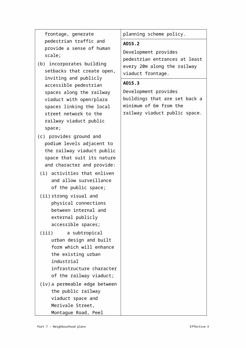
neighbourhood plan/NPP-003b) – 2.9m specified
Development of a site in the Western residential sub-precinct (Wynnum—Manly neighbourhood plan/NPP-003c)
5 16 Residential – 2.9m
Ground storey – 4.3m
2nd storey of podium – 3.5m
Not specified
Development of a site in the Wynnum central business district sub-precinct (Wynnum—Manly neighbourhood plan/NPP-003d)
8 28 Residential – 2.9m
Ground storey – 4.3m
2nd storey of podium – 3.5m
2 storeys
Development of a site in the Bay Terrace sub-precinct (Wynnum—Manly neighbourhood plan/NPP-003e)
5 18 Residential – 2.9m
Ground storey – 4.3m
2nd storey of podium – 3.5m
2 storeys
Development of a site in the Wynnum central business district southern frame (Wynnum—Manly neighbourhood plan/NPP-003f)
5 16 Residential – 2.9m
Not specified
Development of a site in the Waterloo Bay Hotel sub-precinct (Wynnum—Manly neighbourhood plan/NPP-003g) within 10m of the boundary of the site to Byrneside Terrace and Bay Terrace
3 12 Residential – 2.9m
Ground storey – 4.3m
2nd storey of podium – 3.5m
3 storeys to Berrima Street
Development of a site in the Waterloo Bay Hotel sub-precinct (Wynnum—Manly neighbourhood plan/NPP-003g), where adjacent to the heritage place
3 12
Development of a site in the Waterloo Bay 6 21
Part 7 – Neighbourhood plans Effective X

Hotel sub-precinct (Wynnum—Manly neighbourhood plan/NPP-003g) in all other areas
If in the Manly harbour village precinct (Wynnum—Manly neighbourhood plan/NPP-004)
Any development in this precinct Not specified
10.5 Not specified
Not specified
If in the Wynnum Road precinct (Wynnum—Manly neighbourhood plan/NP-006)
Development of a site within 25m of the northern and eastern boundaries of the precinct
2 Not specified
Not specified
Not specified
Development of a site in all other areas of this precinct
5 Not specified
Not specified
Not specified
Note—Maximum building height is measured to the underside of the ceiling of any habitable room.
Note—Maximum number of storeys is from ground level.
Note—Development within the Waterloo Bay Hotel sub-precinct (Wynnum—Manly neighbourhood plan/NPP-003g) is in accordance with Figure b.
Note—Development within the Wynnum Road precinct (Wynnum—Manly neighbourhood plan/NPP-006) has a maximum of 2 storeys in accordance with Figure c.
Note—Development within the Waterloo Bay Hotel sub-precinct (Wynnum—Manly neighbourhood plan/NPP-003g), located adjacent to the heritage place requires a minimum 5m setback to the heritage place.
Part 7 – Neighbourhood plans Effective X
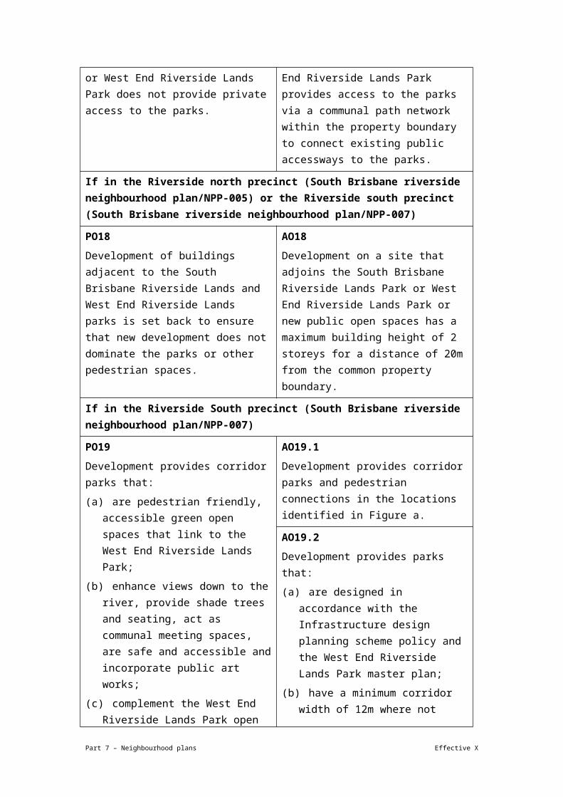
View the high resolution of Figure a– Indicative structure plan for Waterloo Bay Hotel sub-precinct (PDF file size is 202Kb)
Part 7 – Neighbourhood plans Effective X

View the high resolution of Figure b– Indicative structure plan for Wynnum Road precinct (PDF file size is 120Kb)
Part 7 – Neighbourhood plans Effective X

View the high resolution of Figure c– Public domain (PDF file size is 80Kb)
Part 7 – Neighbourhood plans Effective X