jtethys.orgjtethys.org/.../03/...solid-waste-dumpsite-at-west-of-e… · web viewjtethys.org
TRANSCRIPT

Environmental Impact Assessment of Erbil Dumpsite area - West of Erbil City-
Iraqi Kurdistan RegionSirwa Qadir Smail Gardi
Department of Geology, College of Science, University of Salahaddin, Kurdistan Region, Iraq
Mobile number: 00964-750-4753127
Abstract
During the last few years, the concern about the protection of the environment has largely increased
due to the contaminants mainly with anthropogenic origin and have affected and continue to
threaten human resources especially air quality, surface soil and groundwater. Solid wastes are
produced every day in urban societies as a result of human activities and in an attempt to dispose of
these materials; man has carelessly polluted the environment. Erbil City has experienced an
economic development, intense urbanization and change in consumption patterns that have resulted
in an increase of solid waste generation. The study area lies within Erbil plain, about 10 km west of
Erbil City, covering about 7km2 and located on a hill conjoined by two drainage valleys. The aim of
the study is to provide prediction, detecting possible contamination and highlighting the
repercussions of unprotected and uncontrolled waste disposal practices in Erbil dumpsite. Soil and
water samples were collected nearby the Erbil dumpsite to assess the baseline data. The results of
water sample analyzed are within the acceptable limits and they are suitable for drinking and
irrigation. The results of soil sample analysis show that clays are of loam types with strongly
alkaline. The septic tank discharges valley has been polluting the soil. On the other hand, no
adverse impact on ground water quality is anticipated in the present project. Evidence of lack of
adherence to proper landfill structure, operation a management was recorded and recommendations
were postulated for rectification. The Environmental Impacts Assessment (EIA) that was
undertaking for this project has also postulated mitigate set simple measures. The assessment
revealed lack of environmental awareness by public, workers, and personnel, which can be solved
through regular environmental training programs.
Keywords: EIA, Dumpsite, Groundwater, Soil, Erbil, Iraqi.
1. Introduction
Disposal of refuse occurs all over the world and proves to be a major problem. Kurdistan region,
like many parts of the world experiences problems in terms of shortage and degradation. Many
factors affect environmental pollution such as industrial, agriculture and the wastes and affluence 1

released by human activity. They are generally classified into solid, liquid and gaseous. The means
of waste disposal like that of many industrialized towns in developing countries is the use of open
dump landfills. This is an improper solid waste management system which is globally accepted as
the major cause of environmental pollution in the world (Ogungbe et al., 2012). The major problem facing the construction of new communities or development is the source of
water. Groundwater is considered as one of the main sources of water in a semi-arid and arid
environment. Groundwater resources have been under rapidly increasing stress in large parts of the
world due to pollution. Pollution is primarily the result of irrigated agriculture, industrialization, and
urbanization, which generates diverse wastes, with the attendant impact on the ecosystem and
groundwater. With a rapid increase in population and growth of industrialization, groundwater
quality is being increasingly threatened by the disposal of urban and industrial solid waste (Raju et
al. 2011; Singh et al. 2015a).
Pollution from solid wastes always begins with precipitates carrying the leachates into land
surface and ends with the water reaching surface water or groundwater. Solid waste projects are
made to prevent the environment from the negative effects of solid wastes. The pollutant
components of solid waste are: leachate, gas emission, odor, noise and bad view. These are the main
pollutants that are expected from every kind of solid waste. The effects are generally the same but
its level may be changed according to the region (Gulmez, 1999). Therefore, EIA of solid waste
project is prepared in the aim of minimizing these effects. Precipitate on the refuse dumpsite will
either infiltrate the refuse or run off over as land flow. The extent of pollution is greater in high
rainfall areas than less humid and arid areas. Permeable soil permits rapid movement of
leachates unlike in less permeable zone (Ogungbe et al, 2012).
Careless dumping of refuse and poor management can greatly affect one's health. Poor management
of solid waste materials leads to potentially disastrous environmental and health hazards. Among
health hazards that have resulted from the lack of an effective disposal system are periodic epidemic
and communicable diseases (Azeez and Eyinla, 2014).
Environmental Impact Assessment (EIA) is a formal study process used to predict the
environmental consequences of a proposed major development project. An EIA identifies ways to
minimize the problems and outlines ways to improve the project’s suitability for its proposed
environment. The International Association for Impact Assessment (IAIA) defines an
environmental impact assessment as the process of identifying, predicting, evaluating and
mitigating the biophysical, social, and other relevant effects of development proposals prior to
major decisions being taken and commitments made (Zamorano et al., 2005).
The (EIA) process, which originated in the United States in the late 1960s and early 1970s, has been
adopted extensively in the rest of the world. The U.S. model and that of other developed countries 2

share basic principles and reflects commonly agreed-upon approaches to similar problems (Jennifer,
2008). Open dumps are the oldest and most common way of disposing of solid wastes. The practice
of landfill as a method of waste disposal in many developing countries is far from standard
recommendations (Mull, 2005; Adewole, 2009).
2. Research gaps
Although, some studies on impact assessment of dumpsites in developed countries have been
conducted, no significant work has been reported in Erbil City. As a consequence of ignorance of
environmental impacts, lack of rigorous impact assessment and inefficient technologies, the Erbil
dumpsite sector is not on a sustainable path. Improving environmental performance is therefore an
essential step towards attaining sustainable dump-siting practices. The aim of this paper is to
provide a review on EIA studies on dumpsite area in Erbil and propose an EIA approach by taking
Erbil Dumpsite as the case study. EIA can conclude the non-viability of the project based on its
findings, leading to scraping or major changes of the project.
3. Research objectives (The purpose of the EIA)
Although EIA should have been carried out at the advent stages this EIA phase will address
the existing current conditions and possible means for rectification. It aims to achieve the following:
1- The preventing and protecting of the public from the possible infections and contamination
from the municipal waste.
2- Providing safe, clean and healthier environment to the local communities.
3- Protecting of the public health from the spread of potential infectious diseases.
4- Providing an overall assessment of the social and biophysical environments of the affected
area by the proposed construction of the project.
5- Improving project acceptance.
6- Avoiding impacts and violations of laws and regulations.
7- Improving project performance.
8- Protecting the productivity and capacity of natural systems and the ecological processes
which maintain their functions.
4. Site characterization
3

The Erbil dumpsite sit lies within Erbil plain, about 10 km west of Erbil City, covering about
7km2 with Latitude 36° 11' 40.60"N and Longitude 43° 53' 05.10"E (Fig. 1) and located on a hill
conjoined by two drainage valleys. The elevation of this site is about 435m above sea level.
The Erbil dumpsite operation life since year 2001 (Municipal ministry), and currently receives
all types of solid waste. Daily disposal is about one thousand ton (Dawd, 2009, Personal
Communication) of solid waste of varied types.
The location is generally used for any type of general household waste. The waste dumped at
this site includes domestic waste, e.g. kitchen waste, food leftovers, paper, newspaper, metal and
glass cans, packaging, plastic, glass, cartoon, wood, metals, ceramics, leather, cloths and batteries.
These wastes can spontaneously ignite and produce noxious smoke smell and which varies
according to waste composition with greater risk to the operating management staff. Construction
and demolition waste, which consist of sand, bricks and concrete block are also dumped. Dumping
activities started from the top of the site by merely toppling the waste over the edge.
Some components of the waste are very hazardous or toxic such as liquid solvents seen along
one of the valleys, north of the Erbil dumpsite ridge. Furthermore it was observed that black water
from household septic tanks was also discharged nearby the site.
With an increasing population in Erbil City, as a capital of the Iraqi Kurdistan Region and
changing production and consumption patterns in the last few years, levels of degrading waste is
increasing at alarming rates.
Existing waste disposal sites are rapidly filling up and with the ever increasing costs for disposal of
waste; it is becoming very difficult and expensive to dispose of food waste which is the main waste
in the Erbil dumpsite. Therefore any sector that generates food waste is facing a potentially huge
disposal problem, particularly those establishments catering on a large scale, such as hospitals,
schools, universities, ministry of Defense sites, prisons, hotels, restaurants, and even shopping
centers and parks, in addition to household food waste. The wastes in the Erbil dumpsite is
decomposing continually and a sludge of decomposed soup known as leachate will develop. The
age of a landfill significantly affects the quantity of leachate formed. Leachate generated in the
initial period of waste deposition (up to 5 years) in landfills has pH value range of 3.7 to 6.5
indicating the presence of carboxylic acids and bicarbonate ions. With time, the pH of leachate
becomes neutral or weakly alkaline ranging between 7.0 and 7.6. Landfills exploited for a long
period of time give rise to alkaline leachate with a pH range of 8.0 to 8.5 (Słomczyńska and
Słomczyński, 2004). It is therefore important that a systematic study on Environmental Impact
Assessment (EIA) is carried out to assess the effects (both positive and negative) of dump siting on
the environment, which may also include historical, cultural and social aspects.
4
5. EIA legislation in Kurdistan Region
The principal legal instrument in Kurdistan Region of Iraq that deals with EIA is the
Evaluation of the Environmental Impact and Environmental Consents, 2008 (Law No. 8, Waqaehi
Kurdistan, 2008).
This Act establishes the impacts of the environment and gives it the responsibility and
authority for the protection of the environment. The principal legal instruments having a direct or
indirect bearing on the project are summarized below (from Law 8, Chapter One, Section 5, 2008):
Section 5- 12 of the Environmental Law 2008 state:
Any person normal or moral, general, specific, mixed or any agency, after execution of this
law, perform an activity effects on the environment, must prepare a study to assess the
environmental impact of activities and projects that have been constructed, then send it to the
Ministry in order to take over a convenient decision about it, in which the study must include the
following:
First: Evaluation of the positive and negative effects of the project, establishment or factory on the
environment.
Second: Suggested means to prevent and treat the causes of pollution, in which attains the
engagement of the environmental instructions and controls.
Third: The probable and emergency pollution states and the reservations that must be carried out.
Fourth: Possible substitutes for using more clean environmental techniques.
Fifth: Minimizing, recycling and reusing the wastes.
Six: Assessing the cost of environmental interest and impairment that have been produced by the
projects.
Section 5- 13 of the Environmental Law 2008 state:
The Minister can request from moral or normal person, or from any agency, before execution
of this law, perform an activity affecting the environment, to prepare a study for EIA of their
projects if they need requirements of protecting the environment.
Section 5- 15 of the Environmental Law 2008 state:
First: Work to prevent the negative environmental effects that resulted from their projects, or from
projects that submitted under their supervision, or from projects consent about it.
Second: Taking over all the suitable procedures to ensure the application of rules forenamed in this
law on their projects or the projects submitted under their supervision, or which proposed
5
to issue the consent about it with the regulations and instructions issued according to this
law.
Third: Observing and following up the environmental regulations, standards, and keeping them in
their projects or projects submitted to their supervision, and providing the council with
periodic reports about it.
Fourth: Making coordination with the council before issuing any consents or permits related to
performing strategic or giant activities affecting on the environment.
6. Baseline data collection (Base line environment)
The term "baseline" refers to the collection of background information on the biophysical, social
and economic settings proposed project area. Normally, information is obtained from secondary
sources or the acquisition of new information through field samplings, interviews, surveys and
consultations with the public (Ogola, 2007).
This section describes the existing environmental settings in the study area and is based upon the
secondary information collected from the published sources, reconnaissance survey, primary socio-
economic survey and environmental monitoring of air, noise, soil, ground water and surface water
in the study area.
The major purpose of describing the environmental settings of the study area is:
_ To assess the existing environmental quality, as well as study the environmental
impacts due to the proposed project.
_ To identify environmentally significant factors or geographical areas that could
preclude any future development.
Additional purposes of the baseline studies is to provide sufficient information so that decision
makers unfamiliar with the general location can develop an understanding of
_ The project need.
_ Environmental characteristics of the study area.
The baseline environmental conditions are established through literature survey and field works.
6.1 Geologic setting and structure
According to Jassim and Goff (2006), the study area lies within the Chemchamal- Butma
Subzone of the Foothill Zone, which is the central unit of the Unstable Shelf. The zone was visibly
affected by the Late Tertiary Phases of the Alpine orogeny. (Buday, 1980). Butma-Chemchemal
subzone, however, has very conspicuous long and deep synclines with thick Pliocene molasses
dominated by conglomerate and the strata are essentially horizontal (Jassim and Goff, 2006). Erbil
plain is considered to be among these plains as a broad syncline between two main anticlinal 6
structures, Pirmam from east and Khurmala-Avana from west (Hassan, 1998). The inner parts of the
synclines contain Quaternary deposits, referred to here as the polygenetic synclinal fill, (Jassim and
Goff, 2006). The geological formations in the study area are described from the older to younger
rock units as follows:
6.1.1 Mukdadiya (Lower Bakhtiari) Formation (Pliocene)
The Mukdadiya formation comprises of fining upwards cycles of gravely sandstone,
sandstone and red mudstone, (Jassim and Goff, 2006). The depth of the upper boundary is not
known.
6.1.2 Bai Hassan (Upper Bakhtiari) Formation (Pliocene)
The Formation consists of molasses sediments represented by alternation of claystones and
conglomerates with some sandstones and siltstones, variations from one of the main constituents to
the other, both laterally and vertically is very common (Hassan, 1998). The major part of the study
area is covered by this formation (Fig. 2). No accurate information is present about the thickness of
this formation.
6.1.3 Quaternary deposits (Pleistocene- Holocene)
According to Jassim and Goff (2006) Quaternary sedimentary veneer of polygenetic origin
covers large areas in the synclines of the Foothill Zone. These synclines often have a central river
system that cuts across, or flows parallel to their axes, the sediments filling the synclines consist
mainly of a mixture of gravel and clay.
6.2 Geomorphology
There are no surface geological features in the studied area, except of some hills and valleys
which are found controlled by the drainage pattern are reflection of the subsurface structures and
rock unit nature. The Erbil area rises topographically from the flat plains in the west and southwest
towards the hills in the north and northeast (i.e. towards the Pirmam Mountain). Erbil central plain
slopes gradually from east to west (Fig. 3), its slope is less than 3°, and the local slopes do not
exceed 8° (Hassan, 1998). In the Erbil areas, the drainage pattern falls into two subdivisions, the
whole of the eastern part of the area drains from the east and the northeast with a parallel system of
streams and valleys toward the central area just west of Erbil city, this is consistent with the general
slope of the area west and southwestwards from the Pirmam Anticline and the western part of the
Erbil area on the other hand shows dendritic drainage pattern over gentle slopes of the ground
(Ghaib, 2001).
6.3 Hydrogeological condition
7
Erbil hydrogeological basin is bounded by Greater zab from north and Lasser zab to the south. Erbil
basin is a wide depression located between southern limb of Pirmam anticline and Dibaga hill zone
(Zurgha Zraw Zurg) which gives a semicircular shape to Erbil basin. These two hill zones are
consisting of Bakhtiari Formation (Majeed and Ahmad, 2002).
The Erbil hydrogeological basin is a structural groundwater basin with at least three sub-basin
units that are separated by minor surface and subsurface structures (Al- Jawad and Hussien, 1988
and Hassan, 1998).
The Pliocene Formations (Bakhtiari) and especially the Upper Bakhtiari (Bai Hassan) is
considered as a major aquifer in the Erbil basin, it is a continental deposit of gravel, conglomerate,
sand and clay. The exposures of the Bakhtiari Formation are found in the higher lands of the basin
(Al- Jawad and Hussien, 1988).
West of Erbil city starting from Touraq village the area between the line division of Kapran
sub – basin, central sub – basin and the main road of Gwer sub district consist of Bakhtiari
Formation with good aquifers which are semi confined (Majeed and Ahmad, 2002).
Depth of static water level is about (20-25) m, with good discharges water zone starts at depth
after 25 m. with presence of surface water in some locations at depth of (10-15) m (Ditto).
Depth to groundwater varies in short distances due to variable topography. According to
Hassan (1998) the groundwater table depth ranges between 30- 50 m in Erbil City, and according to
Al- Ansari et.al. (1981) the water table is usually 50 m deep. Hassan (1998) during his study
noticed that the groundwater moves from east to west side of the Erbil city, so it flows in the same
direction as regional groundwater flows.
6.4 Sample analysis
Soil and water samples were collected nearby the Erbil dumpsite to assess the baseline data
(Table 1) and (Fig. 4).
6.4.1 Soil sample analysis
Soil samples were collected from different locations (Fig. 4) at about 25cm depth within the
activity area including three samples (Table 2) to establish the baseline data at this time. The pH of
soil samples was measured by pH meter equipment and electrical conductivity (EC) by EC
equipment in the Chemistry Department laboratory in Science College- Salahaddin University. The
soil class is clay loam in two first samples and silty clay loam in sample three. The pH of soil is
strongly alkaline based on the classification of Al- agidi (1989).
6.4.2 Water analysis8
Water samples were collected from three water wells at different locations above and behind
the Erbil dumpsite. The pH measurements show that all water samples are of basic type. The
chemical composition of the water wells compared with the WHO (2003) is given in (Table 3). All
water analyzed samples are suitable for drinking and irrigation.
6.5 Biological data
The biological data was carried out by field observation and collection of secondary data.
6.5.1 Flora
The Flora is the presence of plants in a particular area or habitat at a particular time. Most of
the landscape is used as wheat and/or barley pastors and heavily dependent on rainfall frequency for
several decades ago. This means that the natural flora was replaced by cultivated plants in most of
the study area, but still few common herbaceous species and few tree plants are present. All
classified plant species are common and widely distributed in Kurdistan Region. Almost all plants
were familiar and usually treated as weeds in cultivated area. Most cultivated trees were cut as fuel
or been used in furniture or construction of houses by making roofs from tree trunks and covered by
branches and leaves. The vegetations all were present in moderate to high vegetation, while in some
places were naked and bare off vegetations (Al-Mousawi, 1987, Townsend et. al, 1965 and Al-
Rawi and Guest, 1966).
The plants in the area were collected and identified by experts of taxonomy in the herbarium
of Salahaddin University in college of Science using volumes 2, 3, 4, 8 and 9 of Flora of Iraqi and
volumes 1, 2, 3, 4 and 5 of Flora of Europea. The vegetation in and around the study area could be
divided into the following regions:
(1)- Man cultivated vegetation: This can be summarized as:
a- Livestock vegetation which are cultivated nearby houses in the villages.
b- Trees which are cultivated near cultivation areas where farmers cultivate to be used as shading
and resting places such as Morus alba, Morus nigra,Ficus carica and Salix acmophylla when sun
rises at noon time or to be used commercially by cultivating Populus euphratica , especially in well
watered area, which is used usually in construction houses.
(2)- Wild vegetation: This kind of vegetation usually differs in their presence according to rainfall
season weather high or low, where all plants that present in the field are ephemeral plants and grow
9
in rain fall season during winter and spring. The vegetations which were noticed in the field are
classified and listed in (Tables 4 & 5).
6.5.2 Fauna
They are present in a particular area or habitat at a particular time. As has been mentioned in
flora of study area that this area has been used for cultivation by man for several centuries and the
natural vegetation is already replaced by agricultural fields, this has forced natural animals to leave
the area (Dost and Dandelot, 1993 and Salem et al., 2006). Wild life is almost represented by very
few numbers of worms, Jackals, Rabbits, Foxes, and Hyenas…etc.
The fauna in the area were collected and identified by experts of taxonomy of Salahaddin
University in college of Science which using volume 25 of Common and scientific names of
amphibians, domestic animals, birds, invertebrates, mammals, reptiles and aquaculture.
The presence of birds inside study area and around is connected directly or indirectly with
existence of food and water so as for mammals (Table 6). The mammals inside study area that had
been noticed also included domestic animals such as dogs, cats as well as rodents (rats and mice)
(Table 7). Also some of the reptiles and amphibians are present in study area (Table 8).
6.6 Climatic and meteorology
The climatic condition in the study area is characterized by hot summers, and cold winters.
Rainfall is seasonal occurs during late autumn, winter, and early spring months, and there is no
rainfall during summer.
In summer, Erbil is under influence of Mediterranean anticyclones and Subtropical high-
pressure belts which is moving from west, southwest to north, and northeast. Southerly winds blow
carrying sand to the Erbil Governorate raising daily temperature to a maximum value of more than
50°C. In winter Mediterranean cyclones take over moving east to northeast over the Erbil
Governorate and the entire region. The site and topography of the location has a significant effect
on the amount of rainfall, precipitation increase from the southwest to the northeast (Stevanovic et
al., 2001).
The climatic condition is important for waste disposal site, because the wind direction and
wind speed have a considerable role to generate storms at these sites. Also the rate of the rainfall is
one of the most important factor that runoff on the surface of waste disposal sites which seeping as
a leachate through it according to the rate of precipitation, finally contact with the groundwater as a
contaminant material.
10
The study area is located within the Erbil City. The measured data were taken from Erbil
Station (Latitude: 36 12 N, Longitude: 44 02 E, Altitude: 470 m above sea level) (Agro-
Meteorological Monthly Bulletin, 2009).
6.6.1 Ambient temperature
Monthly average ambient air temperatures recorded in Erbil are given in (Table 9).
6.6.2 Precipitation
Annual average total precipitation in Erbil was measured as (150.1 mm) where the maximum
monthly rainfall was measured as (88.7mm) in March, (Table 10).
6.6.3 Humidity
Annual average relative humidity in Erbil was 46.7 %, the minimum relative humidity was 8
%, and the maximum relative humidity was 100 %, (Table 11).
6.6.4 Wind
The annual average wind speed in Erbil was 2.21 m/s. The maximum average wind speed is
3.0 m/s of the SE direction in both months February and June, (Table 12).
6.7 Air quality
There were not available ambient air quality baselines in the study period to be dumped on
neither sufficient equipment nor instrument to be used in measuring the air analysis of the studied
area.
6.8 Noise
In an urban environment, noise levels change from moment to moment. Any project normally
has a significant impact on noise levels until it complete. No monitored noise data was available for
the study area and noise pollution has not been considered as an issue with regard to the dumping of
solid waste.
7. Environmental Impacts and Mitigation Measures
For each potential adverse impact the plan for its mitigation at each stage of the project should be
documented, as this is very important in the selection of the preferred alternative. The objectives of
mitigation therefore are to: find better alternatives and ways of doing things; enhance the 11

environmental and social benefits of a project avoid, minimise or remedy adverse impacts; and
ensure that residual adverse impacts are kept within acceptable levels.
The potential environmental impacts associated with the project are summarized in the following
sections.
7.1 Potential negative impacts
7.1.1 Impacts on physical environment
The potential impacts and mitigation measures on the geology, soil and water resources are as
follows:
1- Geology and soil
An assessment of the impact on soil and geology is based on a review of maps and site
investigations (soils, geology).
One of the typical environmental stresses in the solid waste site is the soil contamination due
to pollution, landscape alteration and waste dumping. For example, soil degradation occurs due to
reduction in vegetation cover. Vegetation is important since protects the soil from erosion by wind.
The kind of geologic material underlying the site is the most important factor, if it is
sediment (gravel, sand, silt, clay), it needs to be impermeable to limit the migration of
leachate, the only sediment that meets that criterion is clay, which makes an ideal landfill
substrate because it has low permeability (Coch, 1995). The results of the electrical survey for
geological condition obtained by Gardy (2010) that this site was composed of alternation of these
clastic sediments. From the results of geo- electrical resistivity indicates the contaminated area by
its low resistivity value if compared with surrounding area. The contamination zone is detected in
the geo- electrical section along traverse A-Aˉ under VES points 2 and 3 in the contaminated area
by septic tanks. The thickness of this zone is about (1.0- 1.5m) (Fig. 5) show the impact of septic
tanks to the near subsurface layers. It can flow by infiltration from the surface to the downward due
to the high porosity and permeability of the lithology. If this process is continued it may contact
with groundwater surface and finally contamination the groundwater. The depth that subject to
contaminate from the surface is about (1.0- 18.0m). The contamination zone is not detected at the
geo- electrical section along traverse B-Bˉ (Fig. 6), because it is far away from the dumpsite and
septic tank impacts. The contamination zone at the geo- electrical section along traverse C-Cˉ was
detected also by its vicinity to the septic tank discharging valley (Fig. 7). The thickness of this zone
is about (4.0m) under VES point 21.
Mitigation measures
12
Soil erosions and land degradation are the main agricultural but limited negative impacts. The
impacts are expected to be moderate to minimal. To protect the soil from erosion, shelter-belts
erected perpendiculars to the prevailing wind direction (wind breaks) are recommended, which
reduces wind speed at the soil surface.
The low permeability of clay materials makes them behave as a natural liner, preventing
leachate from percolating downward as in the geo- electrical section along profile C-Cˉ.
2- Water resources
The use of quantities of water resources are depending on the project requirements during the
activity in a day.
The extraction of water from the vicinity wells for project activities can affect groundwater
availability in the long term and drop the groundwater level. It can affect the quantity and quality of
groundwater refers to time period of the project activity. The water from the Bakhtiari aquifer and
recent deposits are generally also of good quality, with the exception of the waters from shallow
wells, located near cities and villages, which are often contaminated, mainly as a result of the free
seepage of sewage water (Stevanovic and Iurkiewicz, 2009).
Mitigation measures
Groundwater should be used carefully during the project activity.
7.1.2 Air quality impact
Here discuss some potential air quality impacts associated with the Erbil dumpsite to address
these impacts.
1- Gas emissions
Once solid waste dumped will be responsible for a series of reactions. Gasses are generated
by degradation of biodegradable fraction and are influenced by physico-chemical composition of
waste and environmental variables (pH, temperature, moisture, nutrient, etc) (Kumar et al., 2004).
The main constituents of solid waste gas are methane and carbon dioxide; also contain a wide
variety of contaminants such as volatile organic compounds, and particular chemicals may be
present if they have been disposed of at the site (Fig. 8). If the methane reaches a concentration of
over 15 percent it becomes explosive (FELCG, 1997). The gas composition varies greatly
depending on the waste composition and burial conditions (Abu Qdais, 2007). Carbon dioxide and
methane are greenhouse gases, which do not cause harmful effects to the local environment, but
rather affects global warming (Anon, 2005).
13

These gases can move underground away from the site and appear at the surface more than
half a kilometer away from where it started (FELCG, 1997).
Due to long residence times in the atmosphere, some airborne pollutants travel hundreds of
miles from the source before deposition on land, soil or waterways (Davis et al., 1994).
As well as posing a risk of explosion, also it damages vegetation by displacing oxygen from
around the roots of plants, also gas lead to explosion which have damaged property and injured
people (FELCG, 1997).
Mitigation measures
A production gas wells must be used in the site. The main purpose of the collection system is
to minimize explosion risk from methane emissions.
2- Odor impacts
Waste disposal sites often generate objectionable smells due to the decomposition of waste
(Fig. 9). The odor potential at the site and the surrounding area was assessed by level of smelling at
various distances from the working face on the site at various intervals during the day. The Wind
direction has an important role to transport this noxious odor to the surrounding sites. It has been
reported in studies that the offensive odor can reach for a distance of one mile or more from the
waste disposal site (Abu Qdais, 2007).
In the Erbil dumpsite, odors may be generated from:
- Improper and incomplete waste separation;
- Improvised and uncovered trucks transporting the waste to the facility;
- Piled wastes for long periods of time before their processing;
- Maturating compost piles;
- Emission of gases;
- Decomposition of waste; and
- Septic tanks household waste discharge.
There are villages at the nearest Erbil dumpsite; they are far away about 2.5- 6.0 km from the
surrounding villages, and some of them are located downwind from the site such as Sardasht,
Qaryatagh, Jimka, and Binberz. Therefore, odor impact will not affect the closest residential to the
site, it has adverse impact (health impact) on the workers in the waste disposal site.
Mitigation measures
The key mitigation measure is to ensure the implementation of best practices with special
focus on prohibiting waste burning. The proposed mitigation measures include landfilling the waste
14
using the cell phase approach, daily covering of the incoming wastes with sand, capping the cell
following completion.
3- Dust impacts
Main sources of dust are excavation work, bulldozers and trucks movements over unpaved
roads closure activities at the dumpsite (Fig. 10). This factor is classified to be short-term, reversible
and limited as it will only occur during excavation activities. Increased traffic will also increase dust
emissions both on-site and off- site.
Airborne pollution, in particular dust resulting from clearing of the land may further stress the
local flora and fauna, and may also pose a health risk to construction workers and residents in the
vicinity who suffer from asthma or other respiratory ailments (TEMN- LTD, 2006).
Mitigation measures
Dust from construction activities will be minimized by adopting cell approach. The purpose
of adopting such practice is to minimize the environmental impact of the construction and operation
of the dumpsite. During operation phase, dust impacts can be minimized through good site
practices, as follows:
Use of waste compaction and daily cover;
Construction of paved site roads throughout the site and;
Ensuring that wheels of all vehicles are washed before departure from the site.
4- Vehicle exhaust emissions
As municipal solid waste is collected and transported to a disposal or recycling facility,
hauling vehicles emit gaseous pollutants. Few traffic movement and air pollution sources exist near
the waste disposal site.
However, since baseline levels of pollutants are low, emissions from these vehicles are
unlikely to raise the level of air pollutants to hazardous levels (Anon, 2005).
Therefore, the potential impacts of vehicle emissions resulting from vehicles are likely to be
minimal and contained within the site boundaries.
Mitigation measures
As the air quality of the site is bad and the impacts from the vehicles emissions are likely to
be minimal, no specific measures are required. However, it is highly recommended that
maintenance of vehicles be done on regular basis and according to a preset maintenance plan. Also,
it is recommended that vehicles emissions testing to be performed on yearly basis.15

7.1.3 Noise impact
The source of noise and vibrations will appear while using equipments such as shredders,
boilers, generator, vehicular movement, and heavy mechanization, during the construction and
operation phases of the dumpsite. The noise that originates from the trucks and other heavy vehicles
and mechanization during the construction becomes neglectable at distance of 100m from each side
of the route of movement and working, so that it should not be a subject of separate observation
from aspect of negative impact (Anon, 2005). Having in mind that the closest settlements from the
Erbil dumpsite are located at distance bigger than mentioned above, it can be concluded that the
noise will have no negative impact on the population. But it affecting the workers that will work on
the dumpsite will be solved by implementing ordinary measures for protection at work such as ear
plugs.
The Erbil dumpsite is located in an uninhabited area and no sensitive receivers such as
hospitals, mosques, churches, schools, or residential areas exist in the vicinity of the project site.
Mitigation measures
No specific mitigation measures are required. However, it is recommended to plant a green
belt of beautification trees around the site to act as a noise shelter.
7.1.4 Impacts on ecological environment
Possible environmental impacts to the area include:
1- Impact on flora and fauna
Operations in dumpsite can have substantial impacts on terrestrial wildlife, ranging from
temporary noise disturbances to destruction of food resources and breeding habitat.
The most obvious impact to biodiversity from the waste disposal site preparation is the
removal of vegetation, which in turn alters the availability of food and shelter for wildlife. Loss of
flora may result due to vegetation clearing activities for construction purposes and site preparation
of the project components (Anon, 2005).
Mitigation measures
However due to the stated importance of vegetation for livelihood activities, the area should
be preserved from damaging activities useless for the project implementation such as clearance for
trucks' circulation or cut-off for charcoal or other uses. Besides, trucks' circulation should use the
designated roads and trucks and drivers should avoid driving off road.
16
2- Displacement of fauna
Noise, vibrations, artificial lights and emissions resulting from the project activities will lead
to additional migration of fauna from the project's neighboring areas. Although some wildlife may
become accustomed to noise, others will move from the area, potentially reducing the population of
those species in the immediate proximity of the site (Anon, 2005).
Mitigation measures
Faunal disturbance should be minimized from sunset to sunrise, as during this interval fauna
is more active in performing its natural necessities. Most operations should not be carried out during
this period of time. Self-monitoring activities should be carried out to reduce disturbance.
3- Increase of pest species
Worms may increase as a result of the waste presence in the area. In addition, dumpsites can
attract a large variety and number of animals such as feral dogs and cats, rodents, birds, and insects.
These animals, especially pests, are of concern because of their potential to spread disease and to
adversely affect the aesthetic quality of the properties near the waste disposal site (Anon, 2005).
Mitigation measures
A fence should be constructed around the site to limit the entrance of larger animals. Besides,
Waste should be compacted and covered daily to prevent the procreation of vermin and attraction of
birds and other opportunistic species to the site.
4. Impacts of leachate ponds on biodiversity
The presence of leachate ponds may enhance the growth of marginal vegetation and the
establishment of fly and mosquito populations that are sources of nuisance and public health threat
(Anon, 2005).
Mammals and migrating birds are likely to be attracted by the ponds to food. Accordingly,
these animals may be exposed to the risk of toxic substances, which might lead to their death.
Mitigation measures
It is recommended to fence the perimeter of the leachate ponds to prevent access to large
animals. Moreover, the fence should have nettings to keep out small animals. Biocides which are
17

safe to man and environment may be added to the leachate ponds to control mosquitoes and flies.
Moreover, marginal vegetation, if any, should be regularly removed.
7.1.5 Impact on social and cultural environment
1- Socio- economic impacts
This dumpsite is expected to contribute in generating more positive social and other effects
because of the organized collecting and taking care of municipal waste and improving the quality of
life.
Employment and income would be impacted both negatively and positively by the proposed
development. The positive impact is represented by the creation of jobs during the construction
phase of the development.
However the operations are a source of concern to the local community because of issues such
as water pollution, litter, vermin, flies, dust, odor, fire, traffic and noise, each of these should,
however, be controlled and their effect minimized by modern engineering design, good operating
practices and effective management.
Mitigation measures
The project would have major positive impacts on the locals. The project will increase the
economic activities of the locals in different sectors, such as transportation, commerce, repair
maintenance… etc.
2- Land use
The land of Erbil dumpsite is a public property and is not used for any commercial purpose. It
is already utilized for dumpsiting waste and there are no houses located within the site boundaries.
However future expansion of the city needs to be examined as part of EIA also, no inhabitants are
present in informal dwellings on-site. Therefore, the project will not involve displacement of
population now. The region of Erbil lies in a fertile agricultural land (Fig. 11).
Mitigation measures
References should be made to the development plan in relation to the zoning of the land use
and objectives, which include agricultural class type, industrial or others and existing master plans
for the area should be consulted.
3- Transportation
18
Transportation impacts are having impacts to the lack of access routes to the waste disposal
site. As major roads within the community will be affected, the impact is short-term and significant.
Traffic flow on the street comprises a mixture of personal and commercial vehicles. Also due
to rise of noise, vibration, exhaust emissions, dust, dirt and visual intrusion, heavy vehicles on
narrow roads may create traffic management issues including delays to other traffic, damage to
roads and can be a source of complaint. The Lorries will vary; there will often be problems of
traffic congestion and an increase in the likelihood of accidents.
Mitigation measures
No specific mitigation measures are required. However, it is recommended to follow good
maintenance practices and conduct annual emissions testing for the fleet to ensure low emission
levels from vehicles.
4. Impact on settlements and surrounding landscape
The assessment was based on a qualitative evaluation of the land use and landscape character
in the vicinity of Erbil dumpsite and an appreciation of the size and nature of the proposed
development.
Mitigation measures
An awareness program aiming at providing landfill workers with basic knowledge on local
natural resources is suggested to avoid unnecessary disturbing activities to neighboring areas.
5. Health and safety impacts
This aspect discusses the range of the potential health and safety impacts associated with the
project activity.
Human wastes require care in their disposal because they carry diseases from pathogenic as
mitts and ticks, worms, protozoa, bacteria and viruses
Workers (Fig. 12) in the vicinity of solid waste processing and disposal facilities also are
exposed to environmental health and accident risks. Diseases can be transferred from the waste
disposal site to the local community through animal vectors, water, and air. Public safety risks are
mainly posed by the increased traffic caused by the waste collection vehicles.
Environmental and human health risks arise from exposure to hazardous substances in
groundwater, surface water, gaseous emissions and dust evolution as a result of leakage (Slack et.
al., 2005).
The current lack of proper solid waste management is surely having a negative impact on
human health and the environment. Current and historical dumping of wastes, whether in open 19

dumps, is directly polluting the environment and water resources of the area, and is furnishing
breeding habitats for rodents and diseases to flourish (MEEA- Ltd., 2005).
A high number of children and adolescents working on the dumping site had illnesses related
to the respiratory (Fig.13), gastrointestinal and respiratory systems such as upper respiratory tract
infections, chronic bronchitis, asthma, fungal infections, allergic and unspecified dermatitis/ pruritis
– inflammation and itchiness of the skin (Cointreau, 2006).
Health risks from waste are caused by many factors, including:
The nature of raw waste, its composition (e.g., toxic, allergenic and infectious
substances), and its components (e.g., gases, dusts and leachates);
The nature of waste as it decomposes (e.g., gases, dusts, leachates, particle sizes) and
their change in ability to cause a toxic, allergenic or infectious health response;
Manual handling of waste this is carried out without appropriate safety precautions
leading to occupational hazards.
The processing of wastes (e.g., odor, noise, vibration, accidents, air emissions,
residuals, explosions, fires) and
The disposal of wastes (e.g., odor, noise, vibration, stability of waste piles, air and
water emissions, explosions, fires).
These risks relate to the emissions from the solid wastes, the pollution control measures used
to manage these emissions, and the overall safety of the facility (Cointreau, 2006). Furthermore,
sudden peaks in exposure are likely to occur when the lids of waste containers are opened (Ditto).
Domestic animals (e.g., cows, goats, chickens, and horses) are present at most open dumps
and animal infection is likely (Fig. 14). Wastes from slaughterhouses are often indiscriminately
discharged to the same open dumps as municipal solid wastes, raising concern about diseases (such
as Bovine Spongiform Encephalophy, 'mad cow disease', which necessitated the selective slaughter
of hundreds of thousands of cattle in 1996) being spread when animals eat the infected flesh of
other animals (Cointreau, 2006). It may appear in our country in the future if the open dumps are
not controlled.
Vectors which may transfer diseases from the waste disposal site to local communities include
worms, insects, birds and humans.
Nitrate is the major contaminate from septic tanks which discharges along the valley. Nitrate
can have serious and potentially fatal effects for infants that ingest water with high nitrate levels
(drinking water standard is 10 parts per million) (Souder et al., 2007).
Mitigation measures
20

Therefore, in order to minimize health impacts, operational practices already include the
following:
Control of entry and exit to the site;
Control of vermin, insects and birds by compaction of waste and use of daily cover;
Control of birds through use of bird scaring methods and fences around the leachate
collection ponds;
Prohibit manual handling of the waste and use of mechanical equipment;
Providing protective clothing to personnel working on site;
Providing first aid facilities; and
Regular health checks for personnel.
7.1.6 Impacts on soil and groundwater
Areas near waste disposal sites have greater possibility of groundwater and soil contamination
because of the potential pollution source of leachate and septic tanks discharge area originating
from the nearby site. Such contamination of groundwater resource poses a substantial risk to local
resource user and to the natural environment.
Leachate is the liquid generated at the bottom of the waste disposal site is considered one of
the most potentially significant sources of groundwater pollution for waters (Lee and Jones- Lee,
1993). Leachate contains inorganic and organic elements (Slack et al., 2005). Leachate migration
from landfills and the release of pollutants from sediment (under certain conditions) pose a high risk
to groundwater resource if not adequately managed (Venkatesan and Swaminathan, 2009).
Water is one of the most important commodities which man has exploited than any other
resource for the substances of his life. Many parts of Erbil Plain rely on reserves of groundwater for
their drinking water.
Erbil dumpsite, agricultural and industrial activities (Fig. 15) has been identified as the main
pollution sources to groundwater and soil in the study area. The main flows of heavy metals to the
environment are from industrial and municipal wastes, both of which contained a variety of toxic
heavy metals (Chaungcham et al., 2008). This problem is important especially when industrial
wastes are involved because many of these substances are resistant to biological or chemical
degradation and, thus, are expected to persist in their original form for many years, perhaps even for
centuries (Fatta et al., 1999).
Groundwater from the Quaternary aquifer is suitable for use as a source of drinking water and
for industrial uses. However, development of the contaminated sources in the study area is
threatening the quality of the groundwater.
21

Contamination of ground water can take place, if the waste disposal site containing above
substances gets leached and percolates into the ground water table. Hence, no adverse impact on
ground water quality is anticipated in the present project. Even in the very long term (on a timescale
of several hundred years), when these sources are continued, the potential impacts on groundwater
quality are predicted to be slight.
The geophysical investigation revealed that the resistivity value of the study area near the
dumpsite is relatively low about (3.0-4.0 Ω.m) in VES points 2 and 3 compared to those of the
uncontaminated area outside the disposal site as we mentioned it. The electrical resistivity anomaly
near the dumping site was related to septic tank discharges plumes which appear to have seeped at
depth as far as 1.5m below the surface (Gardy, 2010).
The soil at the study area was found to be incapable of preventing the migration of
contaminants, vertically and/or horizontally from the source point. Hence this illustrate that the
septic tank discharge valley has been polluting the soil as well as increasing its vulnerability not
only to the soil and groundwater as it is also capable to effect on the fauna and flora.
The short pathway needed for these contaminants before reaching groundwater was enhanced
by periodic water table fluctuations and infiltrating water during the rainy season. These metals
accumulate near the soil surface and decrease with depth due to adsorption to soil particles.
Adsorption occurs on surfaces of clay minerals, hydrous oxides or iron and aluminum, and organic
matter (GWMAP, 1999). Also the nature of geology has important rule to infiltrate the pollutants
through it, as the geological composition of the study area is of clastic materials have higher effect
to infiltrate. This with time may reach to the groundwater and can contaminate it.
According to Shyler et al. (2009) important soil characteristics that may affect the behavior of
contaminants include: soil mineralogy and clay content (soil texture); pH of the soil; amount of
organic matter in the soil; moisture levels; temperature; and presence of other chemicals.
Septic waste discharged to coarse-textured soils proceeds vertically through the unsaturated
zone and into ground water (Fig. 16). Once in ground water, a septic plume develops and moves
with ground water flow. Approximate times for septic effluent to passes through the unsaturated
zone to ground water range from a few hours to fifty days, depending on the volume of effluent and
the distance to ground water (Robertson et al., 1991; Robertson, 1994; Robertson and Cherry,
1995).
Nitrate is the primary chemical of concern in most septic plumes. Nitrate plumes slowly
attenuate as a result of dilution from recharge water and dispersion within the aquifer. Nitrate
concentrations can exceed drinking water criteria at distances of 100 meters or more from the drain
field (GWMAP, 1999).
22
Factors that may affect an aquifer’s susceptibility to nitrates and the concentration of nitrates
in groundwater include land-use, climate, topography, groundwater flow, infiltration rates,
subsurface biogeochemical conditions, bedrock types, and soil characteristics (Lindsey et al., 1997;
Nolan and Hitt, 2003).
Mitigation measures
- It is recommended conducting a water quality monitoring program to ensure the identification
of any possible contamination and immediately address the problem.
- Use the liner and collection system.
- Maintaining the cover to ensure little or no water will enter.
- Remove the leachate from the liner system.
- Septic tanks should be treated.
- Treatment of leachate: the treatment unit of leachate should be provided with proper lining
system such as high density polyethylene (HDPE) supported by a homogenous sub- base
material.
- Periodical inspections of leachate system should be implemented.
7.2 Assessing current location
Does not apply with the standard, and as such it is being appropriated disposal process.
8. Conclusions
Erbil dumpsite is the major site for collecting manucipal waste in Ebil City. Due to increasing
population rapildy, increase thevolume of the waste consequently it has always been associated with
negative impacts on environment. Based on the sample analysis, the following points are conclused:
1- The results of water sample analysis at three different locations shows that they are within the
acceptable limits WHO (2003). All water analyzed samples are suitable for drinking and
irrigation uses.
2- The results of soil sample analysis at three different locations at far distances away from the
dumpsite shows that they are clay loam types with pH of strongly alkaline with electrical
conductivity of (8.0- 13.0 ms/cm).
3- The septic tank discharges valley has been polluting the soil. While, no adverse impact on
ground water quality is anticipated in the present project.
4- Geo-environmental parametars such as air, soil, agricultural land, vegitation and landforms are
affected directly by dumpsite activities.
5- The population living close to the Erbil dumpsite areas are the worst affected. 23
6- The Environmental Impacts Assessment that was undertaking for this project has also postulated
mitigate set simple measures. The assessment revealed lack of environmental awareness by
public, workers, and personnel, which can be solved through regular environmental training
programs.
9. Recommendations
The geophysical and environmental studies of the Erbil dumpsite have led to the following
recommendations:
1- Design of sanitary landfill to prevent or decrease any possible negative effects on the
environment, particularly the pollution of groundwater, soil and air, also the resulting risks to
human health arising from landfilling of waste.
2- Trace element analysis for water wells around the Erbil dumpsite to establish the baseline
environment.
3- Soil analysis along the household septic tank discharges to detect the level of pollution.
4- Training environmental program for all public to elevate environmental awareness and reducing
waste production.
4- Use of electrical resistivity tomography on future landfill for monitoring purposes.
References:
1. (FELCG) Friends of the Earths Landfill Campaign guide. 1997. The Landfill Campaign
Guide, Report, 111p.
2. (GWMAP) Ground Water Monitoring and Assessment Program. 1999. Effects of Septic
Systems on Groundwater Quality, Baxter, Minnesota. Published by Minnesota Pollution
Control Agency, 37p.
3. (TEMN-Ltd) Technological and Environmental Management Network. 2006.
Environmental Impact Assessment of the Fairy Hill Development Phases, Final Report,
151p.
4. Abu Qdais, H. 2007. Environmental Impact Assessment of Municipal Solid Waste Landfills:
A case Study from Jordan. Eleventh International Waste by CISA, Environmental Sanitary
Engineering Centre, Italy.
5. Agro- Meteorological. 2009. Monthly Bulletin. Ministry of Agriculture, General Directorate
of Agricultural Erbil Agro- Meteorological Sub- sector, No. 1-12.
6. Al- Ansari, N. A., Hedeff, I, E and Salim, Y. N. 1981. Water resources in Iraq. Journal of
the Geological Society of Iraq. Vol. 15, pp 35- 42.
24

7. Al- Jawad, S.B., and Hussien, K.A. 1988. Groundwater Monitoring Network Rationalization
using Statistical Analysis of Piezometric Fluctuation. Hydrological Sciences – Journal – des
Jcience Hydrologiques, 33, 2, pp 181-19.
8. Al- Rawi, A. and Guest, E. 1966. Flora of Iraq. Vol. 2, Printed at the University press
Glasgow, 213p.
9. Anon. 2005. Environmental Impact Assessment, Al Hammam Landfill Project, Final
Report, 95p.
10. Buday, T. 1980. The regional geology of Iraq, Stratigraphy and Paleogeography, Vol. 1, v,
Baghdad, 445p.
11. Coch, N. K. 1995. Geohazards, Natural and Human. 1st edition, 481p.
12. Cointreau, S. 2006. Occupational and Environmental Health Issues of Solid Waste
Management. The International Bank for Reconstruction and Development, 48p.
13. Dawd, K. 2009. Administrator of Projects and Maintenance. Janaeen Company in Erbil
dumpsite (Personal communication).
14. Dost, J. and Dandelot, P. 1993. Collins field guide for larger mammals. Hong Kong. Harper
Collins Publishers. 287p.
15. Fatta, D., Papadopoulos, A. and Loizidou, M. 1999. A study on the Landfill Leachate and Its
Impact on the Groundwater Quality of the Greater Area. Environmental Geochemistry and
Health, 21, pp.175- 190.
16. Ghaib, F. A., 2001. Geophysical Study of the Erbil and Aqra Plains and their Geological
Implications. Unpublished Ph. D. Thesis, Salahaddin University, Erbil, 195p.
17. Gulmez, p. 1999. Predictive Tools in Environmental Impact Assessment of Solid Waste
Projects. 21p.
18. Hassan, E. O. 1998. Urban Hydrogeology of Erbil City Region. Unpublished Ph.D. Thesis,
University of Baghdad, Iraq.
19. Jassim, S. Z. and Goff, J. C. 2006. Geology of Iraq. Published by Dolin, Prague and
Moravian Museum, Brno, 341p.
20. Kumar, S., Mondal, A. N., Gaiknad, S. A., Devotta, S. and Singh, R. N. 2004. Qualitative
Assessment of Methane Emission Inventory from Municipal Solid Waste Disposal Sites: A
case Study. Atmospheric Environment, Elsevier Ltd, Vol. 38, pp. 4921- 4929.
21. Law No. 8, Waqaehi Kurdistan, 2008. Protection and betterment law in Kurdistan Region-
Iraq. Chapter One, Section Five, The Evaluation of the Environmental Impact and
Environmental Consents. Fairness Ministry, No. 90, 1st edition.
25
22. Lee, G. F. and Jones- Lee, A. 1993. Groundwater Quality Protection: A suggested Approach
for Water Utilities. Report to the CA/NV AWWA Section Source Water Quality Committee.
8p.
23. Lindsey, Bruce D., Loper, Connie A., Hainley, Robert A. 1997. Nitrate in Ground Water
and Stream Base Flow in the Lower Susquehanna River Basin, Pennsylvania and Maryland.
United States Geological Survey. Water-Resources Investigations Report 97-4146.
Lemoyne, Pennsylvania.
24. Majeed, R. A. and Ahmad, M. A. 2002. Brief References on Hydrogeological Characters of
Erbil Basin. Unpublished Report.
25. MEEA. Ltd. 2005. Environmental Impact Assessment Report, Solid Waste Treatment
Facility in Ain Baal, Caza of Tyre, South Lebanon, Consulting Environmental Engineers,
161p.
26. Nolan, B. T. and Hitt, K. J. 2003. Nutrients in Shallow Ground Waters beneath Relatively
Undeveloped Areas in the Conterminous United States. U.S. Geological Survey, Water-
Resources Report 02-4289. Denver, Colorado.
27. Robertson, W.D, J.A. Cherry, and E.A. Sudicky. 1991. Ground-water contamination from
two small septic systems on sand aquifers. Ground Water. 29:82-92.
28. Robertson, W.D. 1994. Chemical Fate and Transport in a Domestic Septic System: Site
Description and Attenuation of Dichlorobenzene. Environ. Toxicol. and Chem. 13:183-191.
29. Robertson, W.D., and J.A. Cherry. 1995. In Situ Denitrification of Septic-System Nitrate
using Reactive Porous Media Barriers: Field Trials. Groundwater. 33:99-111.
30. Salem, M. A.; Porter, R. F.; Chritensen, S.; Schiermacker- Hansen, P. and Al- Jabour, S.
2006. Field Guide for Iraqi Birds. Published by Nature Iraq and Wildlife.
31. Shyler, H., McBride, M. and Harrison, E. 2009. Sources and Impacts of Contaminants in
Soils. Cornell Waste Management Institute, Cornell University, p.6.
32. Slack, R. J., Gronow, J. R. and Voulvoulis, N. 2005. Houshold Hazardous Waste in
Municipal Landfills: Contaminants in Leachate.Science of the Total Environment (337), pp.
119- 137.
33. Souder, Miller and Associates. 2007. Peer Review Report for the Village of Corrales to
Evaluate Its Wastewater System Needs. Project Kick- off Presentation to Village of Corrals,
p. 45.
34. Stevanovic, Z. and Iurkiewicz, A. 2009. Groundwater management in Northern Iraq.
Hydrogeology Journal, No. 17, pp. 367-378.
35. Townsend, C.C. and Evan Guest. 1965. Flora of IRAQ, Vol. 1, 2, 3, and 4 published by
ministry of Agriculture, Baghdad, Iraq.26

36. Venkatesan, G. and Swaminathan, G. 2009. Review of Chloride and Sulphate Attenuation in
Groundwater nearby Solid Waste. Landfill Sites. Journal of Environmental Engineering and
Landscape Management, Vol. 17, No. 1, 1a- 1-gp.
37. World Health Organization (WHO), 2003. Guide line for Drinking Water Quality. 3rd
edition, vol. 1, Geneva, Switzerland, 540P.
38. Sissakian, V.K. 1997. Geological Map of Iraq. 1st Edn., Scale 1:250000, Geosurv, Baghdad,
Iraq.
39. Gardy, S., Q. S. 2010. Geophysical Resistivity and Environmental Impact Assessment of
Erbil Dumpsite Area Iraqi Kurdistan Region. M.Sc. thesis, unpublished, Salahaddin
University, Erbil-Iraq, 111p.
40. Chuangcham, U., Wirojanagud, W., Charusiri, P., Milne- Home, W. and Lertsirivorakul, R.
2008. Assessment of Heavy Metals from Landfill Leachate Contaminated to Soil: A case
study of Kham Bon Landfill, Khon Kaen Province, NE Thailand. Journal of Applied
Sciences, Vol. 8, No. 8, pp. 1383- 1394.
41. Davis, M. M., Hotter, G. M., Deforest, T. J. and DiBari, J. C. 1994. Possible Global
Environmental Impacts of Solid Waste Practices. Heritage College, 53p.
42. Al-Mousawi, A. H. E. 1987. Plant Taxonomy, Univ. of Mousel press.
43. Stevanovic, Z.; Ahmad, R. and Dilshad, H. 2001. Water Resources Baseline Survey and
Mitigation Measures (Erbil Governorate). FAO Coordination Office for Northern Iraq,
Water Resources and Irrigation Sub- Sector Groundwater Unit.
44. Jennifer C. Li. 2008. Environmental Impact Assessments in Developing Countries: An
Opportunity for Greater Environmental Security?. Foundation for Environmental Security
and Sustainability, No. 4, Report by USAID, p. 33.
45. Azeez, Y. O. and Eyinla, D. S. 2014. Integration of Geophysical and Geochemical Methods
in the Study of ‘Laka’ Dumpsite Ogbomoso, Oyo State. International Journal of Scientific &
Engineering Research, Volume 5, Issue 10, pp: 302-309.
46. Ogungbe, A. S.; Onori, E. O. and Olaoye, M. A. 2012. Application of electrical resistivity
techniques in the investigation of groundwater contamination: A case study of Ile – Epo
Dumpsite, Lagos, Nigeria. INTERNATIONAL JOURNAL OF GEOMATICS AND
GEOSCIENCES, Volume 3, No 1, pp: 30-41.
47. Ogola, P. F. A. 2007. ENVIRONMENTAL IMPACT ASSESSMENT GENERAL
PROCEDURES. Presented at Short Course II on Surface Exploration for Geothermal
Resources, organized by UNU-GTP and KenGen, at Lake Naivasha, Kenya, p. 16.
27

48. Raju NJ, Shukla UK, Ram P. 2011. Hydrogeochemistry for the assessment of groundwater
quality in Varanasi: a fast-urbanizing center in Uttar Pradesh, India. Environ Monit Assess
173(1–4):279–300. doi: 10.1007/s10661-010-1387-6.
49. Singh S, Raju NJ, Nazneen S. 2015a. Environmental risk of heavy metal pollution and
contamination sources using multivariate analysis in the soils ofVaranasi environs, India.
Environ Monit Assess 187. doi: 10.1007/s10661-015-4577-4.
50. Słomczyńska B, Słomczyński T. 2004. Physicochemical and toxicological characteristics of
leachates from MSW landfills. Pol J Environ Stud 13(6):627–637.
51. Ekvall T. Moral philosophy. 2000. Economics and life cycle inventory analysis. In:
Proceeding Total life cycle conference and Exposition; p. 103–10.
52. Adelowo, O. O.; Akinlabi, I. A.; Fagade, O. E. 2012. Environmental impact assessment of
Attenda abattoir, Ogbomoso southwestern Nigeria on surface and groundwater quality using
geo-electrical imaging and microbiological analysis. Environ Monit Assess, 184, pp:4565–
4574.
53. Mull, E. J. 2005. Approaches toward sustainable urban solid waste management:
Sahakaranagar Layout. Unpublished M.Sc. thesis, Int. Environ. Sci., Lund University, Lund,
Sweden, p. 37.
54. Zamorano M, Garrido E, Moreno B, Paolini A. A. 2005. Environmental diagnosis
methodology for municipal waste landfill as a tool for planning and decision making
process. Sustainable Development and Planning, pp: 545–54.
Table 1: Location of the samples analysis.
Soil Sample Coordination Water Sample CoordinationSample
No.Latitude (UTM)
Longitude (UTM)
Elevation (m)
Well Location
Latitude (UTM)
Longitude (UTM)
Elevation (m)
1 400597 4006541 426 KaniQirzhala (8)
398747 4007442 429
2 399210 4006419 436 Tashyapi 401053 4005990 4363 400318 4006035 412 QaryaTagh (1) 399363 4002660 337
Table 2: Soil sample analysis.
Sample No.
Class(Mirsal, 2008)
Texture(Al- agidi, 1989)
Color(Munsell Book of Color,
1975)
Moisture Content% pH EC
(mS/cm)
1 Clay loam Moderately to medium Very dark brown 16.96 8.7 8.25
2 Clay loam Moderately to medium Dark yellowish brown 13.25 8.7 13
3 Silty clay loam Moderately to medium Dark yellowish brown 15.61 8.6 9.95
28

Table 3: Water sample analysis (mg/L).
Parameters Tashyapi Kani Qirzhala QaryaTagh WHO (2003)Turbidity (NTU) 0.6 0.4 0.4 5
pH 7.6 7.4 7.1 8EC (mmho/cm) 1062 703 516 1530
T.D.S. 680 450 330 1000Hardness (as mg(caco3)/l)
340 232 286 500
Ca 44 47 49 200Mg 39 43 38 150Na 16 9 12 200K 0.51 0.65 0.59 3
HCO3 20 31 37 200SO4 47 41 44 250Cl 29 21 11 250
NO3 5 8 8 50Analyzed in laboratory of Directorate of water Quality Control Department in Erbil.
Table 4: List of herbaceous plants present in study area.
Scientific name Family Kurdish nameChenopodium album Chenopodiaceae SimrkaCadaria draba Asteraceae Dow BasaraRaphanus raphinestrum Brassicaceae ToorowkaCapsella bursa-pastoris Brassicaceae ShelimaConvolvulus arvensis Convolvulaceae LawlawAvena fatua Poaceae ParaspeelkaCentaurea bruguierana Asteraceae DrkaspeelkaAegilops columnaisi Poaceae KutkaAegilops eudata Poaceae KutkaUrtica dioica Urticaceae GazgazokMalva parviflora Malvaceae TolkaMatricari chamomilla Asteraceae BayboonAchilla millefolium Asteraceae BezhanAnchusa italica Boraginaceae GolmizaAlhagi graecorum Fabaceae HushtralukProsopis farcta Fabaceae KhrnookAllium ampeloprasum Liliaceae QuradaAnchusa orientalis Boraginaceae GormizaEuphorbia regelii Euphorbiaceae KhushilkAnemon coronria Ranunculaceae GuladarBellevalia ciliata Liliaceae GlekhaBougardia crypostigma Leonticaceae TirshokaBrassica santheniae Brassicaceae TurokaBromus danthoniae Poaceae GanmokaCeutaurea solstitiales Asteraceae DirkazardaCephalaria syriaca Dipsacaceae ZewanCyperus rotundus Cyperaceae SutkaGalium coronatum Rubiaceae NooskaGundelia tournefortii Asteraceae KangirGlaucium grandiflorum Papaveraceae GulalaynisanLolium rigidum Poaceae GiaganmaMedicago hispida Fabaceae SeparaPapaver bornumelleri Papaveraceae GulalasuraMuscari neglectum Liliaceae PiazokaPlantago ovata Plantaginaceae Bznagui
Table 5: Trees and shrubs that are present as natural flora or cultivated plants in the study area.
29

Scientific name Family Kurdish name Plant case
Nerium oleander Apocynaceae Zhala Wild
Melia azedarach Meliaceae Tasbeeh Cultivated
Ficus carica Moraceae Hanjeer Cultivated
Eucalyptus camaldulensis Myrtaceae Eucalyptos Cultivated
Eucalyptus glauca Myrtaceae Qalamtuz Cultivated
Callistemon lensiolata Myrtaceae Filcha Cultivated
Myrtus communis Myrtaceae Murtik Cultivated
Platanus orientalis Platanaceae Chinar Cultivated
Populus euphratica Salicaceae Speedar Cultivated
Salix babylonica Salicaceae Shorabi Wild
Salix acmophylla Salicaceae Darabi Wild
Tamarix pentandra Tamaricaceae Daragaz Wild
Morus alba Moraceae Tooyspi Wiled & cultivated
Morus nigra Moraceae Tooyrash Wild & cultivated
Table 6: Showing birds that are present in study area.
Scientific Name English Name Kurdish Name
Buteo buteo Buzzard Saqr
Streptopelia decaocto Collard dove Kokokhti
Corvus splendens Common crow Qala rash
Tringa hypoleocus Common sandpiper Titerwaska
Hirundo rustica Common swallow Paraselka
Galerida critala Crested lark Sofaqita
Sternus roseus Starling Reshola
Passer domesticus House sparrow Cholaka
Table 7: Showing mammals fauna in study area.
Scientific Name English Name Kurdish Name
Cannis familaris House dog Sag
Felis domesticus House cat Pisheela
Rattus rattus House rat Girj
Mus musculus House mouse Mishk
Canis aureus Jackal Torek
Hystrix indica Porcupine Seekhur
Vulpes vulpes Fox Rewi
Leprus nigricollis Hare Karweshk
Hemiechinus auritus Hedgehog Zhuzhik
Crocuta crocuta Spotted hyena Kamtyar
Table 8: Showing the reptiles and amphibians that are present in study area.
30

Scientific Name English Name Kurdish Name
Hemidactylus flaviviridis House gecko Marmelka
Varanus flavescens Monitor lizard Marmelkay Deshti
Bufo surdus Toad Boqi Sarzawi
Rana previceps Frog Boqi Aw
Table 9: Monthly temperature variations in Erbil (after Agro- Meteorological Monthly Bulletin,
2009).
Months MaximumTemperature C°
Minimum Temperature C°
January 18.5 -3.2February 20.4 3.6March 17.2 9.6April 29.7 7.5May 39.2 15.3June 42.1 20.4July 40.0 27.6August 39.5 26.3September 39.7 12.2October 34.2 15.0November 27.1 5.6December 20.2 5.5
Table 10: Precipitation in Erbil (after Agro- Meteorological Monthly Bulletin, 2009).
Months Average Total Precipitation (mm)
Months Average Total Precipitation (mm)
January 1.6 July 0February 29 August 0March 88.7 September 10.1April 28.6 October 5.3May 0 November 2.3June 5.4 December 8.1
Table 11: Monthly relative humidity in Erbil (after Agro- Meteorological Monthly Bulletin, 2009).
Months Average Humidity (%)
Max. Average Humidity (%)
Min. Average Humidity (%)
January 58.2 77.5 38.9February 56.6 73.6 39.6March 61.7 80.2 43.6April 51.4 71.7 31.3May 33 45.8 20.4June 26.6 37 16.1July 28.4 38.9 17.9August 25.9 36 15.8September 34.1 46.3 22October 36.6 47.9 25.3November 61 75.9 46.1December 71.9 84.6 59.2
Table 12: Wind conditions in Erbil (after Agro- Meteorological Monthly Bulletin, 2009).
Months Average Wind Speed (m/s) Wind Direction (Degree)January 1.6 117.4February 3 117.9March 2.7 147.1April 2.5 149.7May 2.4 190.3June 3 187.3
31
July 1.7 200.3August 2 166.8September 2 167October 2 161.6November 1.6 146.7December 2 119
Figure captions:
Figure 1: Maps show: a- Iraq, location of Erbil Province is indicated, b- Kurdistan Region of Iraq
and c- Erbil City, location of the study area is indicated (Red line).
Figure 2: Geological map shows the study area (After Sissakian, 1997).
Figure 3: Topographic map of Erbil province shows the studied area.
Figure 4: Map shows water and soil samples locations.
Figure 5: Geo-electrical section along traverse A-Aˉ (after Gardy, 2010).
Figure 6: Geo-electrical section along traverse B-Bˉ (after Gardy, 2010).
Figure 7: Geo-electrical section along traverse C-Cˉ (after Gardy, 2010).
Figure 8: Exposed gas emission from Erbil dumpsite.
Figure 9: Household septic tanks at the Erbil dumpsite.
Figure 10: Dust generation during construction phase.
Figure 11: Agricultural lands near Erbil dumpsite.
Figure 12: Workers during sewage dumping at the Erbil dumpsite.
Figure 13: Children working in the Erbil dumpsite.
Figure 14: Cattle watering from the running septic tank stream.
Figure 15: Industrial wastes in the study area (agricultural plots).
Figure 16: a- Convoy of waste loading tankers heading towards the site. b- Sewage is discharged at
one point and c- Developing little stream as consequence to continued discharge.
32

Figures:
Figure 1
33
Figure 2
Figure 3
34
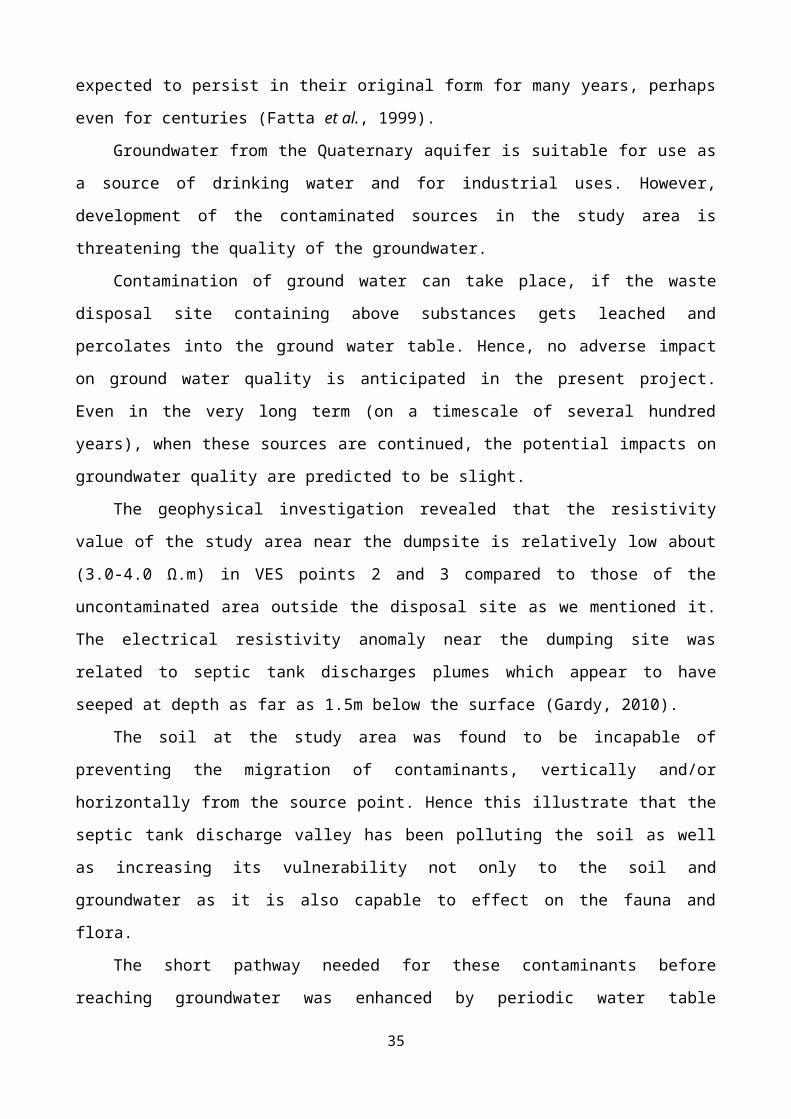
Figure 4
Figure 5
35

Figure 6
Figure 7
Figure 8
36

Figure 9
Figure 10
Figure 11
Figure 12
37

Figure 13
Figure 14
Figure 15
Figure 16
38
a b c