· web viewaldo trees are planted in suitable selected locations to reinforce stability of the...
TRANSCRIPT

Vízgazdálkodás - Water ManagementDr. Zsembeli, József
Created by XMLmind XSL-FO Converter.
Vízgazdálkodás - Water Management:Dr. Zsembeli, József
Publication date 2011Szerzői jog © 2011 Debreceni Egyetem. Agrár- és Gazdálkodástudományok Centruma
Created by XMLmind XSL-FO Converter.

Tartalom .............................................................................................................................................................. 51. Chapter 1. Water and water management ......................................................................................... 1
1. Lesson 1. ................................................................................................................................. 11.1. Water cycle in nature .................................................................................................. 11.2. Water balance ............................................................................................................. 11.3. Components and sub-processes of surface stage of water cycle in nature ............... 21.4. Precipitation ............................................................................................................... 2
1.4.1. Precipitation measurement ............................................................................ 21.4.2. Remote precipitation measurement survey methods ..................................... 21.4.3. Thiessen polygon method (nearest neighbour) ............................................. 31.4.4. Inversion-distance method ............................................................................ 51.4.5. Isohyetal method ........................................................................................... 61.4.6. Geo-statistical methods ................................................................................. 7
1.5. Snow .......................................................................................................................... 71.6. Evaporation ................................................................................................................ 81.7. Interception ................................................................................................................ 81.8. Transpiration .............................................................................................................. 91.9. Relative evaporation and actual evaporation .......................................................... 101.10. Evaporation measurements .................................................................................... 101.11. Computation of areal evaporation ......................................................................... 211.12. Potential evaporation computation ........................................................................ 211.13. Actual evaporation computation ............................................................................ 22
2. Lesson 2. ............................................................................................................................... 222.1. Infiltration ................................................................................................................ 222.2. Measurement methods ............................................................................................. 232.3. Characteristic parameters ........................................................................................ 232.4. Relation between absorption tension and saturation .............................................. 252.5. Groundwater ............................................................................................................ 262.6. Groundwater dynamics ............................................................................................ 272.7. Formation of new groundwater .............................................................................. 292.8. Runoff ...................................................................................................................... 29
3. Topic related questions ......................................................................................................... 302. Chapter 2. ....................................................................................................................................... 33
1. Lesson 1. ............................................................................................................................... 331.1. Sustainable Water Management ............................................................................... 331.2. 2.1. Water Management in general .......................................................................... 34
2. Lesson 2. ............................................................................................................................... 362.1. Tasks and Aims of Water Management ................................................................... 36
3. List of references .................................................................................................................. 394. The Hungarian experince in combating nutrient run-off from rural areas (Figure 32-71) ... 39
3. Chapter 3. Watercourses ................................................................................................................ 611. Lesson 1. .............................................................................................................................. 61
1.1. Classification of watercourses ................................................................................. 611.2. General classification of water streams ................................................................... 61
2. Lesson 2. ............................................................................................................................... 672.1. A river valley as a landscape element ...................................................................... 67
3. Topic related questions ......................................................................................................... 70
Created by XMLmind XSL-FO Converter.

Vízgazdálkodás - Water Management
4. Literature: ............................................................................................................................. 714. Chapter 4. Floods ........................................................................................................................... 72
1. Lesson 1. ............................................................................................................................... 721.1. Flood protection measures ....................................................................................... 74
2. Topic related questions ......................................................................................................... 773. Lesson 2. ............................................................................................................................... 794. Topic related questions ......................................................................................................... 81
5. Chapter 5. Flood protection ........................................................................................................... 841. Lesson 1. ............................................................................................................................... 84
1.1. Flood prevention measures in the country and settlements, reduction of disasters . 842. Lesson 2. .............................................................................................................................. 87
2.1. RECOMMENDATIONS FOR FLOOD PROTECTION ........................................ 872.2. RECOMMENDATIONS CONCERNING INSTITUTIONAL ASPECTS AND COORDINATION OF ACTION .................................................................................... 89
6. Chapter 6. DYKES ........................................................................................................................ 921. Lesson 1. Purpose and type of dykes ................................................................................... 92
1.1. Disadvantages of dykes ........................................................................................... 941.2. Dyke Routing ........................................................................................................... 951.3. Dyke Heights and Shapes ........................................................................................ 951.4. Dams and their types (Fig. 92-101) ......................................................................... 99
2. Lesson 2. ............................................................................................................................ 1042.1. Technologic Process of Dyke Construction ......................................................... 1052.2. Safety Measures, Equipment and Works Implemented in Dykes ......................... 1052.3. Spatial planning measures ..................................................................................... 1092.4. Flood plains ........................................................................................................... 1092.5. Demarcation of flood-prone areas ......................................................................... 1102.6. Protection of specific facilities .............................................................................. 1112.7. Protective Structures, Basic Requirements ........................................................... 1112.8. Earth dykes ............................................................................................................ 1122.9. Technical flood protection materials ..................................................................... 114
7. Chapter 7. WETLANDS .............................................................................................................. 1161. Lesson 1. ........................................................................................................................... 116
1.1. General profile of wetlands ................................................................................... 1161.2. Key words and their meanings .............................................................................. 1161.3. General profile of wetlands ................................................................................... 1181.4. Classification of wetlands ..................................................................................... 120
2. Lesson 2. ............................................................................................................................ 1222.1. Hydrology of wetlands .......................................................................................... 122
2.1.1. Wetlands as a component of the water circulation in the basin ................ 1222.1.2. Water balance of wetland habitats ............................................................ 1232.1.3. Wetlands in the plans of the water management of reception basins ....... 124
3. References .......................................................................................................................... 127
Created by XMLmind XSL-FO Converter.

A tananyag a TÁMOP-4.1.2-08/1/A-2009-0032 pályázat keretében készült el.
A projekt az Európai Unió támogatásával, az Európai Regionális Fejlesztési Alap társfinanszírozásával valósult meg.
Created by XMLmind XSL-FO Converter.

1. fejezet - Chapter 1. Water and water management1. Lesson 1.1.1. Water cycle in natureThe water cycle in nature (Figure 1) is driven by the Sun. Solar radiation causes evaporation of water, primarily from oceans. Water vapours are transformed into clouds, and water falls back as rain or snow. A portion of water flows underneath the ground surface, and another portion evaporates from ground, water or snow surfaces, or transpires through plants. The rest infiltrates into the ground and can reach even the groundwater table. Groundwater flows from higher elevations towards valleys and penetrates the surface in a form of springs, riverbeds or seas, or is drained by means of artificial interventions.
1.2. Water balanceThe water cycle can be quantitatively expressed by the water balance equation. The Earth’s water cycle is closed, without any gains or losses. A long-term water regime balance of continents is expressed by the following equation
precipitation = runoff + evaporation
In the water management, determination of the water regime of a river basin or an administrative or geographical unit is often relevant. For observation of a closed catchment area over a certain time interval, the water regime equation has the following form:
hN = hA + hV + hS
hN [mm] precipitation heighthA [mm] runoff heighthV [mm] evaporation heighthS [mm] supply (retention) change
The values are considered as mean values for the same projection of an area and apply to the same time interval.
Created by XMLmind XSL-FO Converter.

Chapter 1. Water and water management
1.3. Components and sub-processes of surface stage of water cycle in natureOne of the most complex problems of hydrology is modelling the surface stage of the water cycle in nature. Particularly striking is the ecosystem’s vertical structure and complexity.
1.4. Precipitation1.4.1. Precipitation measurement
Point measurement methods
The precipitation height for a short period of time is measured by precipitation gauges (rain gauges), and for a longer period of time by means of collection vessels (totallisers). Except regions at high altitudes and with large amounts of precipitation and snow, a device commonly used in Germany is HELLMANN precipitation/rain gauge (Figure 2). The area covered by this gauge is 200 cm2, and the collection vessel’s capacity is 1.2 l to 1.4 l; the gauge is normally placed at a height of 1m above the ground surface.
The working principle of the Hellmann gauge (sampling area 200cm2, measurement height 1m above the ground surface) is based on a float. Precipitation water flows from the collection vessel into a metal cylinder containing the floating object. The float is fitted with a spindle to which a recording pen is attached which records the water height onto a registration drum. When the height of water corresponding to the precipitation height of 10mm is achieved, the metal cylinder is emptied by means of a siphon system and the precipitation water is drained into the collection vessel (Figure 2).
Measurement errors occurring with point measurement methods are caused by effects of wind which reduce the amount of precipitation entering the collection vessel, losses due to water trapped on walls of the collection funnel which also reduce the aggregate amount of precipitation, and minor losses due to evaporation from the collection vessel.
1.4.2. Remote precipitation measurement survey methods
Remote survey methods are used to make records of area precipitation which is relevant in terms for hydrology, with a spatial resolution level that can hardly be achieved with point measurement methods, given the large spatial variability of precipitation.
Remote survey methods are indirect precipitation measurement methods involving radar and satellite precipitation measuring.
Created by XMLmind XSL-FO Converter.

Chapter 1. Water and water management
A radar (Radio Detecting and Ranging) device uses the fact that water droplets reflect radiation within a microwave range. A radar device serves as a radiation transmitter and receiver of the reflected energy. The intensity of the received signal enables determination of the amount of precipitation across the observed area, with a time lag corresponding to the location's distance from the radar.
Satellite precipitation measurements are delivered by geo-stationary satellites or satellites orbiting over the Poles along elliptical paths at a height of approx. 900km. Unlike these satellites, geo-stationary satellites move at the Earth’s orbital speed, and therefore stay over the same Earth’s point at a height of approx. 36,000km. Precipitation amounts and periods may be estimated pursuant to the type, thickness, surface temperature and size of clouds by means of various empirical methods. Satellite data are particularly important in areas where no terrestrial measurement stations are available, as well as over oceans.
The above described remote survey method entails a disadvantage in that terrestrial observations require calibration.
Areal precipitation
Below we discuss the most frequent areal precipitation determination methods.
Arithmetical mean
This method is suitable for use only for flat areas, longer time intervals (months, years) and an even spread of precipitation measurement locations. The method is based on the below equation:
hN [mm] areal precipitation[mm] precipitation height at station im [ - ] number of stations employed
1.4.3. Thiessen polygon method (nearest neighbour)
With this method, the examined area is partitioned and each catchment area’s point is assigned the precipitation of the appropriate nearest station (“the nearest neighbour”). Values measured at the stations are interconnected by thin lines; then, central perpendiculars to these lines are drawn, which create a polygon around each station (sample area) (Figure 3).
Created by XMLmind XSL-FO Converter.

Chapter 1. Water and water management
The following equation applies to areal precipitation:
hN [mm] areal precipitationCi [-] significance of station i[mm] precipitation height of station im [ - ] number of stations employed
and the following significance factors apply:
Created by XMLmind XSL-FO Converter.

Chapter 1. Water and water management
Ci [-] significance of station iAi [km2] area pertaining to station i
1.4.4. Inversion-distance method
This objective method is based on an orthogonal raster grid put onto the reference area. The precipitation value of each raster point can be determined from the appropriate surrounding stations. The most frequent method is the quadrant method. With this method, basic coordinate lines with the north-south and east-west orientation are drawn at each raster point within the area. The precipitation height of a raster point is computed from the four closest precipitation measurement stations of the reference points located in each of the four quadrants:
hN,j [mm] precipitation height of raster point jCi,j [-] significance of raster point j vis-à-vis station i[mm] precipitation height of station i
where significances Ci,j mean appropriate relative reciprocal quadratic distances between each of the four precipitation measurement stations and a raster point:
Created by XMLmind XSL-FO Converter.

Chapter 1. Water and water management
Ci,j [-] significance of raster point j vis-à-vis station idi,j [m] distance between station i and raster point j
Thus, areal precipitation is computed as:
hN [mm] areal precipitationhN,j [mm] precipitation height of raster point jm [-] number of raster points
1.4.5. Isohyetal method
Isohyetal lines (isohyets) joining equal precipitation heights are interpolated from precipitation of neighbouring stations in proportion to their distances. Areal precipitation is determined by the following equation
Created by XMLmind XSL-FO Converter.

Chapter 1. Water and water management
hN [mm] areal precipitationCi [-] weighted share of isohyetal area ihI,i [mm] precipitation of isohyetal area im [-] number of isohyetal areas
This method has an advantage in that it enables reflection of known factors affecting the spatial distribution of precipitation, e.g. orographic factors or terrain-related factors, in the isohyetal line design. In the past, the method was primarily used for representation of mean precipitation distributions over a number of years.
1.4.6. Geo-statistical methods
Compared to the previously mentioned common methods, geo-statistical methods have an advantage in that they enable reflection of characteristics of the area in question and the various precipitation events in the interpolation exercise. This reflection is done by means of a 'variogram' which represents the spatial variability of an examined variable. This facilitates the determination of significances C i according to the precipitation variability, while with the Thiessen polygon method or the inversion-distance method these significances depend only on the measurement grid, and therefore remain constant for different events. Furthermore, geo-statistical methods predict errors in estimates for unknown points that are to be interpolated, and therefore are particularly suitable for the measurement grid planning.
One frequently used geo-statistical method is the Kriging method. With this method, precipitation at unknown points is computed through linear combinations of significant surrounding measured values. Weights of measured values are determined with a view to obtaining estimates which are free of distortion and best in terms of minimised error square sums. The Kriging method is an exact extrapolation method with which estimates at measurement points exactly correspond to measured values.
1.5. SnowThe snow cover is normally described by the following measurement parameters: snow depth d, which is measured by a snow stake; specific weight of snow r s, i.e. weight of snow per unit of volume; water content hN,W
(amount of water contained in the snow cover in a form of water or ice), also referred to as water value (value in mm above the horizontal surface); duration of snow cover, i.e. the number of days of a year during which the snow cover is present (important for thermoregulation). The water value hN,W [mm] is computed as
hN,W = rs d
rs [kgdm-3; 1kgdm-3 = 10mm of water per cm of snow]d [cm]
The water content can be computed by means of energy balance of the snow cover indicating the amount of energy needed for the ice crystal melt. However, the energy balance computation requires extensive
Created by XMLmind XSL-FO Converter.

Chapter 1. Water and water management
measurement data, including temperatures, moist, wind, solar radiation and distribution of temperatures across the snow cover, which are normally not available. Therefore, simplified thermoregulation methods are applied in practice, such as the degree-day method. The following equation applies to the amount (runoff) of water from the snow cover G [mm d-1]:
G = ki (Ta – T0)
ki [mm°Cd-1] degree-day factorTa [°C] daily mean air temperatureT0 [°C] air temperature at transition from snow to rain
1.6. EvaporationAs a part of the water cycle in nature, evaporation together with precipitation interlinks the separate Earth’s water reservoirs (oceans-atmosphere-land). Evaporation is expressed as height (evaporation height hV) in mm, related to a reference period of time of even distribution of the evaporated water layer.
Evaporation occurs during precipitation, before rain falls onto the ground or its vegetation cover. The following types of evaporation are distinguished:
• evaporation
• interception
• transpiration
Evapotranspiration refers to the aggregate of evaporation and transpiration.
Evaporation refers to evaporation from exposed water surfaces, vegetation-free land, and water vapours caught by plants. It depends on the following meteorological conditions: air saturation deficit, air temperature, air movements and heat radiation from ground.
1.7. InterceptionInterception means a type of precipitation which is retained by plant surfaces and evaporated without reaching the ground surface. Interception is affected by various factors:
Created by XMLmind XSL-FO Converter.

Chapter 1. Water and water management
• Meteorological parameters: duration, height, intensity and temporal distribution of precipitation; wind; solar radiation; potential evaporation intensity;
• Properties of vegetation: types of wooden plants or vegetation; age; rate of canopy closure; development over the seasons of the year.
The interception process is participated by all forms of vegetation. For forests, coniferous trees in general have higher interception effects than leafy trees. On average, spruces consume approx. 1/3 of annual precipitation through interception, while agricultural vegetation only 6% to 12% of annual precipitation.
Interception is measured by comparisons between measurements done under a vegetation canopy and on exposed ground.
1.8. TranspirationTranspiration is the process by which vapour is emitted to the air by plants as a result of their metabolism. Transpiration is subject to the same factors as evaporation. Furthermore, the type of plants, location, season of the year, and properties of soil are taken in account.
Determination of transpiration as an isolated parameter is hardly possible, and therefore it is generally measured only in combination with evaporation.
Created by XMLmind XSL-FO Converter.

Chapter 1. Water and water management
1.9. Relative evaporation and actual evaporationIn order to facilitate separate observation of atmospheric phenomena, the hypothetic concept of potential evaporation hV,p has been introduced. This term is defined as the maximum possible evaporation height in a single location or landscape area at given meteorological conditions, subject to availability of an optimum amount of water.
Actual evaporation hV,r is the evaporation height occurring in a single location or a landscape area at given meteorological conditions and the actual currently available amount of water. Due to insufficient availability of moisture, in many areas actual evaporation is often lower than potential evaporation. The equation h V,p = hV,r
applies only if an optimum amount of water is available.
1.10. Evaporation measurementsEvaporation may be measured in a single location (point) by means of water balance methods. Alternatively, it can be derived from the water balance maintenance equation, provided that all other terms have been determined.
Created by XMLmind XSL-FO Converter.

Chapter 1. Water and water management
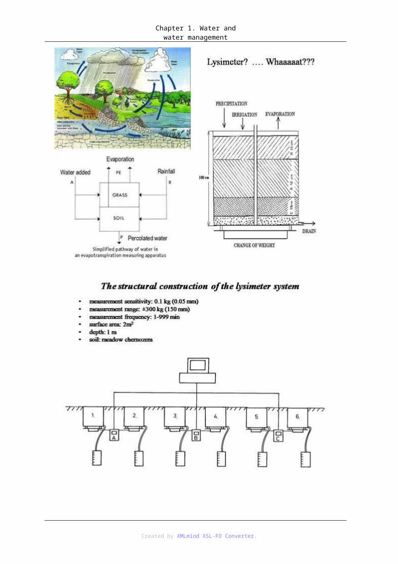
An evaporimeter (evaporation gauge) measures evaporation values of surfaces which are permanently maintained in a moist condition (filtration paper, or ceramic discs), or by means of open evaporation vessels filled with water, where the water loss is measured by the change in the vessel’s water level. However, the best way of measuring evaporation is by means of lysimeters (Figure 4). Lysimeters are natural areas covered by vegetation with a surface of at least 1 km2 and depth of 1 to 2m. They are jacketed, which means that seepage water may be collected and measured in the same way as precipitation.
Created by XMLmind XSL-FO Converter.

Chapter 1. Water and water management
Potential evaporation is determined by means of a simple balance equation, provided that the jacketed soil is maintained in a sufficiently moist condition e.g. by artificial raining. If a lysimeter determines the change in soil’s moisture by weighing, the current evaporation height hV [mm] is defined by the following formula:
hN [mm] precipitation heighthA,u [mm] ground runoff height (seepage)hS [mm] change in vessel’s level
Created by XMLmind XSL-FO Converter.

Chapter 1. Water and water management
Lysimeters enable, within certain limits, projection of the evaporation height onto other locations and larger areas.
The last evaporation measurement methods are the vapour current method and the energy balance method. The former method allows representation of the evaporation height hV [mm] according to the aerodynamic profile method based on a diffusion model as a product of the exchange coefficient for vapour AW [kg m-1s-1] and the vertical gradient of relative air humidity:
u [%] relative air humidityz [m] geodetic height
The exchange coefficient can be determined pursuant to the vertical gradient of wind velocity. Both wind velocity and relative air humidity must be known at the highest temporal resolution.
With the energy balance method, evaporation is treated as a thermal balance component.
Created by XMLmind XSL-FO Converter.

Chapter 1. Water and water management
Created by XMLmind XSL-FO Converter.

Chapter 1. Water and water management
Created by XMLmind XSL-FO Converter.

Chapter 1. Water and water management
Created by XMLmind XSL-FO Converter.

Chapter 1. Water and water management
Created by XMLmind XSL-FO Converter.
Chapter 1. Water and water management
Created by XMLmind XSL-FO Converter.

Chapter 1. Water and water management
Created by XMLmind XSL-FO Converter.

Chapter 1. Water and water management
Created by XMLmind XSL-FO Converter.

Chapter 1. Water and water management
1.11. Computation of areal evaporationAreal evaporation is the emission of water from certain area into the air. This is not a measurable parameter. A number of evaporation computation methods are available, distinguished by examined type of evaporation, number of contemplated determining factors, and required resolution. Methods applied in Germany are stipulated in Ordinance 238 DVWK (DVWK, 1996).
1.12. Potential evaporation computationBy means of an example we describe the equation of the frequently used Penman method, where aerodynamic conditions and components of solar radiation are combined. They are applied to relations which are derived empirically, meaning that the determination of potential evaporation hV,p [mm] relies on commonly available climatic data. The equation is as follows: :
ws [-] significance factor of solar radiationRB [mm d-1] solar radiation balancet [d] number of days for which computation is madevW [m s-1] mean daily wind velocitypD,S [Pa] saturated vapour pressure as per equation (2.15 )pD [Pa] current vapour pressure as per equation (2.16 )
Created by XMLmind XSL-FO Converter.

Chapter 1. Water and water management
tL [°C] air temperatureu [%] relative air humidity
1.13. Actual evaporation computationActual evaporation hV,r [mm] is often determined through reduction in potential evaporation:
[-] reduction factorhV,p [mm] potential evaporation height
Factor reflects availability of moisture in soil. Hydrological models of basins which jointly simulate maintenance of the water balance in soil often yield hV,p as the output value, which is reduced according to the available water in soil to actual evaporation ratio. The Haude method offers a simple way to determining actual evaporation. The formula relies on a single measurement per day (14:00 o’clock). This has been applied primarily in the artificial irrigation of fields by sprinkling. The Haude formula is valid only in temporal, humid climatic regions:
hV,r [mm] actual evaporation heightfH [mmPa-1d-1] Haude factorpD,S [Pa] saturated vapour pressure as per equation (2.15 )pD [Pa] current vapour pressure as per equation (2.16 )t [d] number of days for which computation is made.
2. Lesson 2.2.1. InfiltrationInfiltration as a component of the water cycle plays a central role in the distribution of precipitation between surface water and groundwater; it reduces and delays the runoff portion, supplies necessary moist to soil for vegetation, and contributes to the increase in groundwater supplies. Intensity of infiltration is expressed as water height in mm per unit of time.
Created by XMLmind XSL-FO Converter.

Chapter 1. Water and water management
Excessive water which is unable of draining or precipitation infiltrate with a sharply formed and closed water front. A portion of water is retained, and therefore forces keeping water in pores decrease and the infiltration rate drops. During the infiltration process in soil with clear microstructure, three zones are formed.
The saturation zone is a thin layer which is saturated due to precipitation or flooding. The next zone is the soil reservoir zone, which is exposed to further wetting, and therefore becomes a transport zone. In addition to the gravitation potential, the force keeping water in soil pores in the wet front has such soil matrix potential, which facilitates vertical movement of the wet front.
However, the actual infiltration process is strongly co-determined by the macro-pore system. Macro-pores are long, mostly vertical cavities formed by vegetation roots, zooedaphone, as well as mechanical and thermal loads.
The amount of infiltrated water depends on both properties of precipitation and properties of soil and its vegetation.
2.2. Measurement methodsInfiltration and seepage through soil masses may be computed from measurement data obtained by weight-recordable lysimeters. Another alternative is measuring these two values by a double-circuit infiltration gauge. The infiltration rate is established from the velocity of water level drop in the inner circuit. Water is used for wetting areas of measurement and suppressing errors due to side infiltration. For larger areas, seepage through the top soil layer may be determined by measuring water flowing out from a drain.
The water content can be established by means of a number of devices. The working principle of a Time-Domain-Reflectometer (TDR) is based on the fact that mixed ground-air-water dielectricity is dominated by dielectric constant water. Therefore, the TDR device determines dielectric constant values through the propagation velocity of a voltage jump on two parallel conductive bars in soil. Thus, water content in the dielectricum between the conductive bars in volume per-cent is estimated.
Another classical gauge used to determine the water content is a neutron probe which can be used for direct measurement of a change in the water content in soil. Neutrons are emitted by a source of radiation present in the probe’s measurement part. Fast neutrons thus emitted are diffused and decelerated by hydrogen atoms of soil water. A portion of these decelerated neutrons is registered by the probe’s measurement (counting) tube and converted into electric impulses. The number of impulses can be deemed to be the water content value.
2.3. Characteristic parametersThe essential property of soil in terms of hydrology is its capacity to retain water on the one hand, and drain water on the other hand. A number of different special parameters of soil are applied in practice in order to characterise water contents. The following can be distinguished:
• Gravitational water which penetrates larger pores due to effects of gravitation, and thus gives rise to new
Created by XMLmind XSL-FO Converter.

Chapter 1. Water and water management
groundwater.
• Capillary water which is retained in medium-size pores due to effects of surface tensions and adsorption forces.
• Adsorption water which is tightly bound onto particle surfaces as water film due to the hydrating and electrostatic effects. The maximum thickness of such film is 20 molecule layers.
The following parameters area required in practical hydrological applications in order to determine the water content characteristic: porosity, degree of saturation, field capacity and wilting point.
Porosity n [Vol.-%] is defined as the quotient between volume of cavities Vp [cm3] and total volume Vg [cm3]:
In addition to the absolute porosity value, the movement of water in soil is also determined by pore sizes and the secondary pore system.
The water content in soil [Vol.-%] is the ratio of water content Vw [cm3], which can be received from a soil sample by drying at 105°C, to the total volume of the sample Vg [cm3]:
The degree of saturation s [-] is the water content to porosity ratio:
Created by XMLmind XSL-FO Converter.

Chapter 1. Water and water management
Field capacity FK [Vol.-%] is the amount of water which soil is able to retain against the gravity without affecting evapotranspiration over a longer period of time. Since values are obtained from different locations and therefore are not quite comparable, a moisture equivalent FÄ [Vol.-%] as a laboratory parameter has been introduced. The moisture equivalent defines the amount of water which remains in soil after the soil has been drained by vacuum of a magnitude depending on the type of soil.
The minimum water content at which, if not achieved, a plant irreversibly wilts is referred to as permanent wilting point PWP [Vol.-%]. Again, these values are not comparable due to involvement of a too big number of different factors, and therefore an equivalent wilting point EPW [Vol.-%] has been introduced, which indicates the water content which remains in soil after the soil has been drained by vacuum of 1.5Mpa.
2.4. Relation between absorption tension and saturationAbsorption tension is a parameter defining the intensity of water formation in soil and depends on the water content. The relation between absorption tension and saturation, or the water retention capacity curve can be obtained by representing the absorption tension or matrix potential as a function of the water content of soil. The curve clearly indicates what water content will remain in soil after draining at certain absorption tension.
Figure 5 shows curves for different types of soil, together with some explaining water formation parameters. By comparing curves of various types of soil we can see that fine-grained soils (such as clay) may accumulate a significantly higher amount of water than coarse-grained soils (such as sand), however, they also need significantly higher tension to drain off. This is because fine-grained soils have a larger water/soil surface and therefore their adsorption forces are higher but, on the other hand, the diameter of pores is lesser. However, compared to large pores, small pores drain off only at significantly higher vacuum magnitudes. This clearly indicates that the relation between absorption tension and saturation reflects the pore size distribution.
Created by XMLmind XSL-FO Converter.

Chapter 1. Water and water management
2.5. GroundwaterIn a groundwater system (Fig. 6) the groundwater surface is the upper boundary separating the groundwater area from the aeration area lying over it. If air pressure is present there, the groundwater surface and groundwater are referred to as unconfined. The groundwater table, or the summation of the geodetic height and the piezometric height for a point of the examined groundwater body in an observation tube, indicates the groundwater surface level only if no major vertical movements occur in the tube.
If an impermeable stratum covers the rock stratum that drains water (aquifier) and water inflow from higher strata is present, then the pressure on the groundwater surface is higher than the pressure of the surrounding air. In such case, the groundwater is groundwater with tension and the aggregate of all summations of geodetic heights and piezometric heights for a point of the examined groundwater body (water level heights in observation tubes) equals to the piezometric surface of the groundwater.
Created by XMLmind XSL-FO Converter.

Chapter 1. Water and water management
In order to enable measurement of groundwater storage and its temporal fluctuations, the groundwater stage is examined in groundwater measurement locations (observation wells, groundwater levels). The groundwater stage is the distance of the groundwater table between a single location of measurement and a measurement point, which is mostly the upper edge of a tube or well. Periodical measurements are done by means of instruments emitting acoustic or optic signal upon reaching the groundwater level. Measured values of each point of measurement are recorded in a form of a hydrograph, or in case of larger areas of groundwater contour lines.
2.6. Groundwater dynamicsExamination of underground water flows requires differentiation between a number of velocity concepts, since water may not flow across the entire cross-sectional area, but only through a porous area interconnected by longer sections.
Flow velocity of the entire cross-sectional area, computed as a quotient of the flow rate and the cross-sectional area size, yields so called filtration velocity or Darcy velocity vf [m s-1]
kf [ms-1] hydraulic conductivity at water saturationIst [mm-1] water-level gradient in the observation tube
In the equation (2.22), the declining gradient is defined as a negative number, though the flow velocity always points towards the declining gradient direction.
The equation (2.22) applies only in the specific case of one-dimensional filtration flow at full saturation with water. The general case of three-dimensional flow at both saturated and non-saturated conditions is described by the basic dynamic equation
Vf [ms-1] filtration velocity vectorkf() [ms-1] hydraulic conductivity depending on the water content [m] total potential
Hydraulic conductivity or permeability kf() [m s-1] is computed as a function of the water content according to the below formula:
Created by XMLmind XSL-FO Converter.

Chapter 1. Water and water management
kf [m s-1] hydraulic conductivity at saturation with water [Vol.-%] water content0 [Vol.-%] residual water content, if kf = 0n [Vol.-%] porosity [-] significance factor; here often = 3
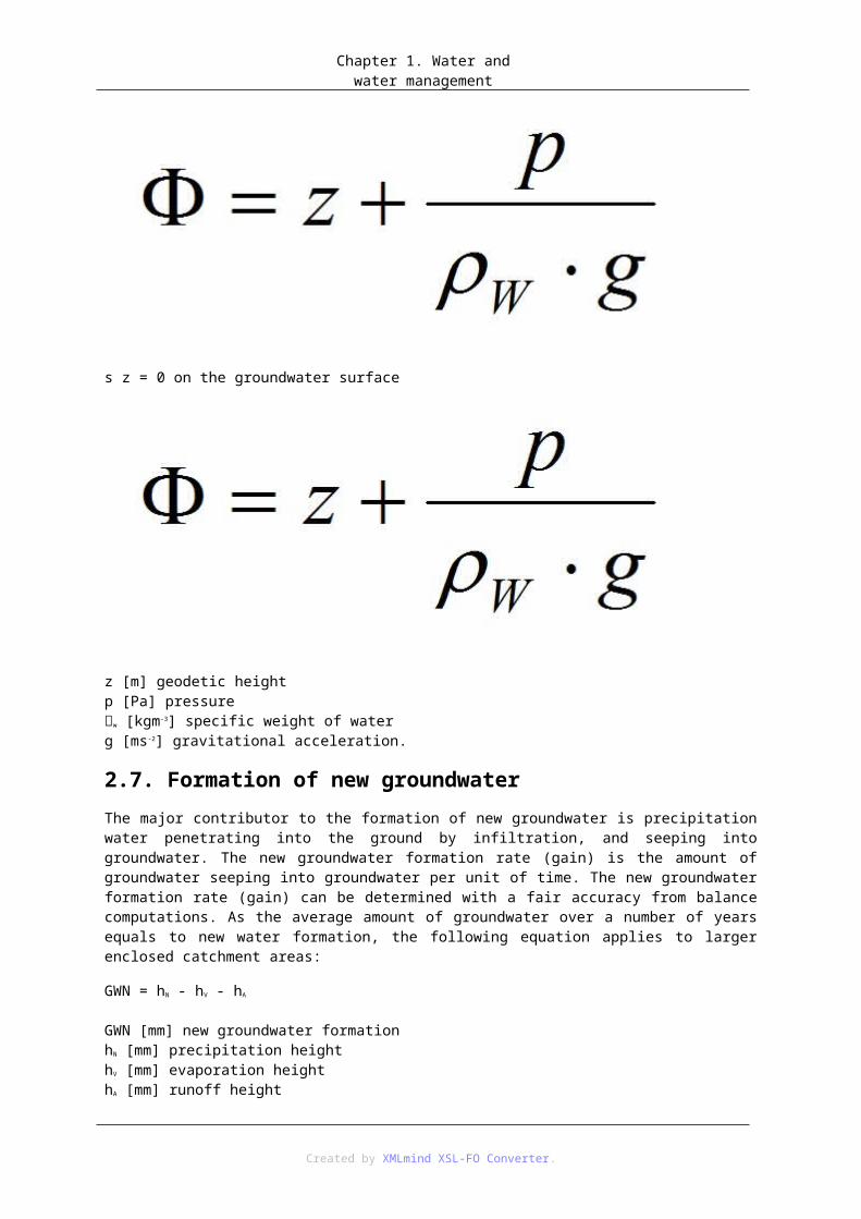
The total potential [m], expressed in terms of height, yields:
s z = 0 on the groundwater surface
Created by XMLmind XSL-FO Converter.

Chapter 1. Water and water management
z [m] geodetic heightp [Pa] pressurew [kgm-3] specific weight of waterg [ms-2] gravitational acceleration.
2.7. Formation of new groundwaterThe major contributor to the formation of new groundwater is precipitation water penetrating into the ground by infiltration, and seeping into groundwater. The new groundwater formation rate (gain) is the amount of groundwater seeping into groundwater per unit of time. The new groundwater formation rate (gain) can be determined with a fair accuracy from balance computations. As the average amount of groundwater over a number of years equals to new water formation, the following equation applies to larger enclosed catchment areas:
GWN = hN - hV - hA
GWN [mm] new groundwater formationhN [mm] precipitation heighthV [mm] evaporation heighthA [mm] runoff height
2.8. RunoffA model of three runoff components relies on a vertically structured soil system: surface runoff comprising runoffs above the upper surface edge; interflow consisting of runoff originating in ground strata located close to the surface or the bottom vegetation zone; and groundwater runoff formed by groundwater. Direct runoff consists of fast components of surface runoff and the fast portion of interflow. The portion of precipitation contributing to direct runoff is referred to as actual precipitation. Base runoff is composed of slow components of interflow and groundwater runoff.
Created by XMLmind XSL-FO Converter.

Chapter 1. Water and water management
In practice, specific runoff q is normally expressed as q [m 3s-1km-2] and is defined as the quotient between runoff rate QA [m3s-1] of a certain channel (drain) point and the appropriate catchment area size AE [km2]:
3. Topic related questions1.What are the two main fields of meteorology?
• a.0 statistical meteorology and deterministic meteorology
• b.1 dynamic and synoptic meteorology
• c.0 theoretical meteorology and practical meteorology
2.Climatology studies:
• a.1 the average condition of the atmosphere in a single location
• b.0 processes occurring in the strata of the Earth’s atmosphere
• c. 0 physical, chemical, geological and biological processes in world’s seas
Created by XMLmind XSL-FO Converter.

Chapter 1. Water and water management
3.Atmosphere
• a. 1 consists primarily of nitrogen and oxygen
• b.0 does not contain any nitrogen
• c.0 consists primarily of carbon dioxide
4.Precipitation and evaporation depend on
• a.1 the water content in air
• b.0 the sea tide and ebb
• c.0 snow cover
5.In terms of size, mesoclimate relates to an area covering
• a.0 several kilometres
• b.0 a continent
• c.1 several hundreds of kilometres
6.The highest precipitation rates have been recorded in
• a.1 the equatorial zone?
• b.0 polar regions?
• c.0 the temporal climatic zone?
7.Condensation refers to
• a.1 the transition of a substance from the gaseous state to the liquid state
• b.0 the transition of a substance from the liquid state to the gaseous state
• c.0 the transition of a substance from the solid state to the liquid state
8.Thunderstorms are
• a.0 orographic precipitation
• b.0 frontal precipitation
• c.1 convective precipitation
9.Global Circulation Models are used for
• a.1 simulation of hypothetic development of the climate change
• b.0 modelling the formation of precipitation
• c.0 simulation of the transformation of precipitation to runoff
10.Precipitation
• a.0 has no temporal variability
• b.1 varies as a function of latitude
• c.0 remains constant across the entire land
Created by XMLmind XSL-FO Converter.

Chapter 1. Water and water management
11.Concentration of runoff is understood as
• a.0the relation between precipitation within a watercourse’s catchment area and he amount of runoff at the area’s discharge.
• b.1translation of actual precipitation into a hydrograph of direct runoff from a surface catchment area.
• c.0the ratio between an actual precipitation height hN,e and a precipitation height hN
Created by XMLmind XSL-FO Converter.

2. fejezet - Chapter 2.1. Lesson 1.1.1. Sustainable Water ManagementWe will know actual value of water when our wells will dry up. Benjamin Franklin, (1706-1790), Poor Richard's Almanac, 1746
These words characterize - much more than long and descriptive publications, articles or presentations - our relation to water which has not changed very much for last 250 years. We appreciate water value only when it is unavailable out of reason of dryness, bad quality or high price. In our territory it is just when we find out that its price has to be increased. This work should contribute to appreciation of water value in our daily life.
View of life quality, human demands and way of life is changing. Around the year 1900 when were built first public water-ducts in our territory, canalization was still rare and sewage tanks were only vision. People appreciated each new development of waterline or canalization. During last 100 years the situation in Slovakia as well as in other civilized countries has changed, but not in such scale as in the most developed countries of the Europe. It is necessary to build constantly new local resources in the form of wells or trapped springs for production of drinking water for provision of resources for new supplying of towns and villages. Where it is not possible, it is necessary to obtain water from surface resources. Population range has also changed significantly during last 100 years. With population increase water need has also risen.
With increasing water consumption also amounts of produced sewage water have risen. Man increasingly develops pressure on the nature. He needs more and more pure superior water for drinking and for other purposes. On the other hand he discharges into all waters - into surface or ground ones - more and more waste waters.
Waste materials are discharged into the waters that were utilized during millenniums only as drinking water or water for crop irrigation or water was simply the resource of mechanism drive and material transport; water becomes the place of disposal of liquid and some gentle solid wastes trapped for example from gaseous emissions. Change of water quality in our territory and also worldwide is very serious during last hundred years. People have polluted not only water but also the atmosphere and the soil. Natural resources are increasingly influenced by human activity. The more resources are polluted the more people need these resources.
Many important personalities of the world have begun to meditate at the end of the 1980`s and in the beginning of the 1990`s on what may happen if we will go on to exploit the nature in this manner. Soon can happen that there will be no sufficiency of pure water. Thus after various stages of ecological struggles there was elaborated preparation of one of the most significant undertaking – the Conference in Rio de Janeiro in 1992. There have met leading scientists, politicians and experts of the whole world in order to say how to leave for future generations the nature where life will be possible.
New period has begun when was changed the opinion on natural resources on first place. The epoch of further development of humankind must be the period when it would be necessary to observe principles of sustainable development - development saving the resources. For this development it is necessary to adjust all our further activities.
Water protection as ground of life is first-rate aim of environmental policy of each state. Water is influenced by various activities. Economic growth must be focused on water management covering in accordance with the environment to meet its important functions in the nature circulation as well as in the landscape economy in the future.
Hydroeconomic exploitation protecting waters as well as man, above all against floods generally abides with following tasks and aims (Sander 1995):
1. Provision of balanced water balance on behalf of ecological balance of waters, from the nature and the landscape to satisfaction of requirements of water users.
Created by XMLmind XSL-FO Converter.
Chapter 2.
2. Long-term qualitative and quantitative provision of water supply for population, agriculture, small and large firms, but in the framework of limited available amount so as surface and ground resources should not loaded exceedingly.
3. Elimination of irregular and limiting conditions of the development in the fields of insufficient water resources by supplying from other areas but under preservation of ecological conditions and development possibility in both areas.
4. Provision of suitable hydroeconomic areas, for public water supply preferentially.
5. Care for the nature state considering area water protection with controlled waste water drainage.
All possibilities for minimalization and prevention of waste water rise are in the first place. It is also necessary to ensure gradual elimination of rainfall water drainage into recipients without utilization or to support their soaking in the place of origin.
It is possible to achieve reduction of waste water production by various technological provisions in manufactural and converting plants or by personal approach towards utilization of drinking water in dwelling areas and in non-manufacturing institutions.
Global problems are issue of human survival worldwide. Their implementation can not be followed-up only from the worldwide view but it is necessary to implement them from basic parts of the world:
• individuals
• human groups
• towns and villages
• regions
• and particular states.
1.2. 2.1. Water Management in generalWater management is the field in which ecology and economics stand imminently along with utilization of renewable natural resource.
All consider water for renewable resource but also limited one which restores in quality and quantity, but which can be also damaged irretrievably. Sufficiency of water forms essential issues of existence whereby water is in the centre of consideration in solution to many tasks. Out of multifunctional water utilization result various requirements for its properties. Many functional properties of water were profiled according to these requirements based on incidence and utilizable amount in particular areas. Their importance increases with the resource decrease. Following historical development of requirements and water functions in the society water achieved many cultural and social properties and importance.
Created by XMLmind XSL-FO Converter.

Chapter 2.
Water management is identified as basic scientific field which investigates hydroeconomic activities and above all is stimulated by actual or potential disproportion between the resources and water need for given purpose. This disproportion must be understood very widely. It is presented not only by insufficient permanent or seasonal coverage of water requirements for satisfying of that are used utility properties of water in certain territory, but also that water resources exceed this requirement permanently or temporarily in undesirable measure and when man does not gain control of them, they cause large damages.
The definition of water management was formulated according to type of hydroeconomic activities. Based on large-scale analysis of international viewpoints has formulated the definition of water management generally as: "Summary of manufacture activities that are realized in working processes which result in water as the product." It is understanding of water only as raw material or production tool not as the nature component. Dominant element is still water for national economy and its utilization, but it is already based on knowledge of the nature and society relations.
Moreover it defines water management as science of interdisciplinary nature developing theoretical elements of complex management of water resources affecting interaction of natural, technical and social and economic processes.
• systematic human activity tending to the utilization, protection and development of water resources and to protection from harmful effects of waters (hydroeconomic activity),
• set of hydroeconomic activities,
• branch of national economy as set of organizations that have hydroeconomic activities as major scope.
It explains also the term water resource for proper understanding of first definition. Following listed standard it designates surface or ground water which is utilized or can be utilized in national economy for population requirements and for other purposes in general behalf.
Hydroeconomic activities include also protection and development of water resources. Here is manifested the phenomenon of water circulation in the nature which ensures renewal of water resources, however activities of the society can significantly modify or change conditions of this renewal. To protect water resource means not only to protect its quality, but also to protect also the space in which it originates (watershed, hydrologic structure) and to ensure conditions for desirable development of its quality. That means protection of surface, earth and ground waters that interact with protected resource. However neither the most consistent protection
Created by XMLmind XSL-FO Converter.

Chapter 2.
need not meet the purpose; for example it may come to permanent air pollution as well as atmospheric water. From this viewpoint it will be necessary to extend the protection on the whole hydrologic cycle that means to atmospheric water and water in the world ocean too.
Request for complex and rational utilization of water resources results above all from their limitation. Single-purpose waterworks built in the past are typical demonstration of extensive utilization of water resources. With increasing demand for water now are built all-purpose waterworks and they are interconnected into specific systems.
In comparison with before listed definitions there is remarkable movement from economic and social meaning of water to ecological meaning and to egality of all these meanings.
Encyclopedian interpretation specifies that water management is the branch of national economy and scientific and technical branch ensuring rational utilization of water resources for economic purposes and water protection as irretrievable natural wealth. According to this author to water management belong water supply, draining and purification of waste waters, agricultural meliorations, transportation, water energy utilization, protection from floods and fishpond cultivation.
In foreign literature is very known the definition presented in the publication issued in 10th edition of „Taschenbuch der Wasserwirtschaft“ (Bretschneider 1993) elaborated by composite author. In the section Hydroeconomic Planning author of this section Gert. A. Schults bestows to water management following meaning:
Water management includes distribution of naturally occurring water in time and space following requirements of the society according to quantity and quality of water. It comes to provisions under water utilization (for example for purposes of drinking water, irrigations, water energy) or protection from water (for example from floods, soil soaking, etc.).
Herewith issues of water balance and amount in water management as well as issues of water quality and also issues of water morphology are included in water management.
Water management as discipline is young formation which develops swiftly. From this viewpoint it is necessaty to understand water management as set of knowledge, methods and proceedings that enable to study and to solve the relations and mutual influencing of natural processes running in part of hydrosphere and social processes relating to water component in particular region. There are intersected proceedings and methods of natural sciences, technical solutions with ecological and economic aspects, that all in real conditions. Therefore also methods used in scientific solution to the problems of water management are very different and their jointing in effort of complex description and problem solution meets with considerable difficulties and is subject of further research.
2. Lesson 2.2.1. Tasks and Aims of Water ManagementTasks and aims of water management are changing and developing with human society development.
Formerly it was mainly provision of water sufficiency for people for drinking and personal consumption and for farm crop irrigations. Gradually it was utilization for ship transportation, source of mechanical and later of electric energy, etc.
With mankind development the aims and tasks gradually expanded, changed and their importance was revaluated.
Nowadays they generally take into account water importance as first. Essential water importance following Kleeberg (1998) may be summarized as:
• Water is concurrently life source and raw material
• Water is one of the most important resources of natural raw materials
• Water plays in the nature the most important role
Created by XMLmind XSL-FO Converter.

Chapter 2.
• Water in its time and space distribution determines conditions of life for people, animals, plants
• Water determines utilization of the landscape, regions
• Water creates the scene, i. e. water is factor of the landscape formation
• Water is part of cultural heritage as well as religious customs and traditions
If we would actually transfer the definition of sustainable development by Brundtland into the conditions of water management it should be interpreted that water as natural resource can be utilized only in such scale that waters (seas, rivers, lakes, ground water) will be preserved for future generations in the same quality and quantity. But these visions are today enforced only in the case of drinking water resources. Requirement of integrated covering and planning of water resource utilization is listed inter alia in chapter 17 in Agenda 21 particularly.
As sustainable water management is designated integrated covering of all artificial and natural water circulations under consideration of three essential aims:
• Long-term protection of water as the environment or as central element of our environment
• Water provision in its various forms as the resource for present as well as for future generations
• Accessing preferred rights for sustainable natural, economic and social development.
In the course of this definition were elaborated principles of sustainable water management after evaluation of the discussions by participants of the symposium „Nachhaltige Wasserwirtschaft“ in Bonn. There are generally nine principles. Because of their extensiveness we present only brief review:
Principle of regionality – it requires so as each region has the conception of hydroeconomic economy with own water resources. Their solution should not influence surrounding regions. It is mainly prevention from threat of foreign resources of drinking water regarding their quality or quantity. Main aim is therefore active recovery of own resources and achieving their original state and efficiency.
Finally the aim of principle of generation connection is that at least effects on future generations to be taken into account at any decision making or at provision that have to be adopted in the field of water management. But time horizon of the solution effect influences also the scope of responsibility for future generations. Whereas for example dams, water-gates and other water structures are built for more than 100 years, their impact on future generations is significant.
Principle of causality – costs for pollution and utilization of the resources must bear those who caused them. Natural catastrophes jeopardizing waters in many cases were not compensated by floods, neither partially nor at all. Instead of these agents the state or special funds often must bear costs for damages in the regions or also abroad. It is not clear how to recompensate future generations for loss of many water resources that are permanently contamined and water must be brought into the territory from other remote regions, of course with much more costs. Assigning of damages to the agent helps to enhance handling with waters qualitatively as well as quantitatively.
Principle of cooperation and participation – in all hydroeconomic decisions must be adequately considered all interests. It is necessary to support the possibility of independent organization and effect in hydroeconomic provisions. The principle of cooperation and participation requires foremost the possibility of democratic control, mainly on local level. Resulting aim is to achieve general control in hydroeconomic decisions. Part of decision rights is transferred to people groups that may contribute to effective decisions. Thus the task is not only "strong" parties participate on the planning, but also other interested parties that share on practical implementation of water utilization or on their protection.
Principle of resource minimalization – it is necessary constantly and continually restrict direct and indirect water resources and energy consumption. Aim of the principle of resource minimalization is not only ensuring suitable utilization of water resources but also providing restriction of waste water rise. Content of waste materials in these waters causes increased need of further energy or material inputs for their removal.
Principle of preliminary care – In the principle of preliminary care must be taken into account all potential influences that should cause significant threats, even when their incidence probability is very low or cannot be
Created by XMLmind XSL-FO Converter.

Chapter 2.
estimated. This principle is extraordinary serious. Only if we want to prevent from nameless risks we can ensure safe conditions also for future generations. Above all it is important in determination of hazardous substances that should not penetrate into waters because recently are no natural purification processes in the nature for these substances. Nevertheless amounts of unknown substances penetrate into waters and we have neither analytical methods for evaluation of their incidence nor determination by any regulation. But their cumulative effect in the ecosystems may eventually cause menace of live organisms.
Principle of reduction of pollution sources – It is necessary to catch most serious forms of pollution already in the place of their origin (not on „end of pipe“) while they are reconstituted only in small amounts of water. After reconstitution and mixing with substances and with waters from other sources of pollution their removal is uncertain and often very expensive. Therefore these principles are almost in total conflict with common sewage network where rainfall waters are mixed with substances in waste waters.
Principle of reversibility – Following principle of reversibility all hydroeconomic provisions should be executed accordingly their effect that could be returned into original state when eventually was found that their impact has been negative. Moreover it is required that potential adjustment of provision for changed conditions should be figured in the provision draft in advance. It is requirement for future generations to amend current clear definite decisions. For example in drafting current constructions it is important to consider also requirements of influenced species and their biotopes. Destruction of species biotope leads of course to the species extinction, too.
Principle of integration – hydroeconomic plans and decisions must in their time horizont match to the time horizon of their effect, duration respectively. For solution to the principle of integration the water what we utilize in various variations of using must be understood as one element, essential element of the nature. It is then utilized as one element. Water utilization was registered in social sections in past years. Negative demonstrations of excessive utilization in one section led to the problems in other utilization areas. For example straightening of channel streams for canalization enhancement can lead to threat in flood flowages.
In discussion on tasks of sustainable water management in comparison with current state of water management it is necessary to discuss and solve following fields (Rudolph 2000):
• Issue of pollutants - for sustainable water management it is required that loading of waters by substances and organisms should not exceed their natural purification capacity.
• Issues of control of water resources – besides rapidly renewable resources are used also other resources for water supply and drainage of waste waters – e.g. energy, raw materials and other substances. Within sustainable development should be used only renewable resources. Requirements must not exceed rate of the resource regeneration.
• Economic issues – within the framework of water management it is necessary to take into account also external costs for the environment. Water price for enterprises and population should be balanced concurrently.
• Development of new strategies for sanitary devices – to achieve sustainability of water management it is necessary to use new technologies of enhanced utilization of resources for rational utilization of water.
• New region (space) oriented strategies of surface and ground water protection – concerning sustainable water management it is required to utilize only resources from exactly defined area for certain supplied territory. It is necessary for achieving of regional sustainable development.
Created by XMLmind XSL-FO Converter.

Chapter 2.
Since the end of the 1990`s are used balance and amount (material) models as basis for the resource utilization management in water management as well as in other fields. Not only water in its quality and quantity is followed but also very exactly concurrent resources, for example materials and energies used for construction and operation of waterworks and sewage facilities as well as balance of substances transported by water, for example nutritious substances, trace elements or harmful materials.
3. List of references• Bretschneider H. akol,1993. Taschenbuch der Wasserwirtschaft, Parey Verlag, 8.
• Kleeberg, H.B., Lobhler, S., Dick, T.,1998. Wasserwirtschaft und Wasserbau in ländlichen Raum, Universität der Bundeswehr, München, 1998
• Rudolph, K.-U., 2000. Nachhaltige Wasserwirtschaft, Technische Universität Harburg, 2000.
• Sander, R.,1995. Wasserwirtschaftspolitik in der Kommunen – Ansätze fűr eine nachhaltige Entwicklung. Deutsches Institut fűr Urbanistik, Berlin, 1995
4. The Hungarian experince in combating nutrient run-off from rural areas (Figure 32-71)
Created by XMLmind XSL-FO Converter.

Chapter 2.
Created by XMLmind XSL-FO Converter.

Chapter 2.
Created by XMLmind XSL-FO Converter.

Chapter 2.
Created by XMLmind XSL-FO Converter.

Chapter 2.
Created by XMLmind XSL-FO Converter.

Chapter 2.
Created by XMLmind XSL-FO Converter.

Chapter 2.
Created by XMLmind XSL-FO Converter.

Chapter 2.
Created by XMLmind XSL-FO Converter.

Chapter 2.
Created by XMLmind XSL-FO Converter.

Chapter 2.
Created by XMLmind XSL-FO Converter.

Chapter 2.
Created by XMLmind XSL-FO Converter.

Chapter 2.
Created by XMLmind XSL-FO Converter.

Chapter 2.
Created by XMLmind XSL-FO Converter.

Chapter 2.
Created by XMLmind XSL-FO Converter.

Chapter 2.
Created by XMLmind XSL-FO Converter.

Chapter 2.
Created by XMLmind XSL-FO Converter.

Chapter 2.
Created by XMLmind XSL-FO Converter.

Chapter 2.
Created by XMLmind XSL-FO Converter.

Chapter 2.
Created by XMLmind XSL-FO Converter.

Chapter 2.
Created by XMLmind XSL-FO Converter.
Chapter 2.
Created by XMLmind XSL-FO Converter.

Chapter 2.
Created by XMLmind XSL-FO Converter.

3. fejezet - Chapter 3. Watercourses1. Lesson 1.1.1. Classification of watercoursesWatercourse beds may be created by a natural process or artificially (channel). From this perspective, watercourses are classified into natural and artificial. Under conditions prevailing in our country, hydrologic significance and ecologic significance of natural streams prevail over those of artificial waterways. However, they are in higher risk at flood wave passages. Thus, a majority of river sections within developed areas of towns and municipalities is regulated by alteration of the riverbed’s shape and flow capacity in order to facilitate conveyance of the maximum projected flow rate.
From a short-tem perspective, water streams are very volatile systems. Many of their parameters fluctuate on a regular or irregular basis. Naturally, such fluctuations, often rather sudden, largely affect properties of the flow. Riverbed rerouting and flooding are natural features of a water stream.
One characteristic of flowing streams is unidirectional water flow. Flowing water forms drainage systems over the entire earth’s surface, consisting of creeks and rivers. The nature of flowing waters between the spring and the mouth into another river or sea is very manifold. Force of the unidirectional flow as typical feature of flowing streams depends on primarily on the gradient. The water flow constantly conveys and removes solved and suspended substances and deposits them in other locations. Flowing streams are a part of river systems enabling spread of organisms. From the spring to the mouth, a river flow gradually extends its width and depth, the temperature rises, as does the scope of annual fluctuation, while the gradient drops.
1.2. General classification of water streamsSurface streams are generally classified into torrents, mountain creeks, creeks, rivers and large rivers.
Torrents are mountainous streams, either independent or as mountainous sections of longer streams, characterised by great and irregular longitudinal gradients, irregular flow directions and irregular cross sections and bottoms. The bed is usually deeply incised into the terrain, and the bottom is made up of large rocks creating natural cross-sectional impediments; spills, cascades and sills are formed. Torrents are normally characterised by significant movement of fluvial sediments and sudden flow rate fluctuations. Different torrents have different properties depending on their type, origin and the quantity of fluvial sediments, determined by geological and pedologic conditions prevailing in the pertaining catchment area.
Created by XMLmind XSL-FO Converter.

Chapter 3. Watercourses
A torrent area is composed by three main zones:
1. drainage area (torrent perimeter), i.e. the runoff area normally identical to the precipitation catchment area;
2. torrent bed (transport area) within which masses of materials are conveyed downstream;
3. debris cone (torrent, dejection) where such conveyed materials are deposited.
Activity of torrents is very dangerous for both development of their own bed and follow up streams (usually mountain creeks) and streams into which torrents mouth (due to fluvial deposit gains) and adjacent areas. Regulation of torrents, traditionally referred to as torrent impoundment, means not only regulation of the bed itself, but intervention in a broader catchment area, involving implementation of bio-technical measures to regulate and control the water passage and the water’s erosive activity, and combat soil erosion and avalanches.
A torrent emanates from a spring located in the highest point of a river basin; its flow starts in the spring and ends in a certain point, from which stream continues to flow as mountain creek. This point is determined though specific research, with due consideration of specific features of the entire catchment area, such as gradient-related, geo-morphologic and economic conditions and the movement of fluvial sediments; this is normally irrelevant in non-torrent streams, as their regulation involves only modification of the bed itself, without improvement of retention capacities of the entire catchment area.
Mountain creeks, unlike torrents, are characterised by developed valleys, rather balanced bed bottom gradients with which the water flow neither takes on nor deposits fluvial sediments; but water levels are still subject to large fluctuations which may disturb the temporary saturation of the stream with fluvial sediments.
Created by XMLmind XSL-FO Converter.

Chapter 3. Watercourses
Creeks are minor streams with small catchment areas, more moderate and balanced longitudinal gradients of the bed and small drift of fluvial sediments. The span between extreme water levels is not as wide as in mountain creeks. However, they are dangerous at flood occurrences, since they can be effectively exposed to sudden snow melting or torrential rainfall, especially if these occur across the entire creek’s catchment area. In its uppermost section, a creek typically has the nature of torrent with high flow velocity. When spilling over rocks or in waterfalls, the flow velocity may reach up to 6m.s-1. The lower velocity limit in lower sections of a creek is defined as 0.5 m.s-1. With this velocity, water is still able of conveying sand grains sized over 5mm.
Created by XMLmind XSL-FO Converter.

Chapter 3. Watercourses
Rivers are water streams with the largest catchment areas, highest flow rates and more moderate and even longitudinal gradients of the bed. Fluvial sediments conveyed by a river are crushed into small-grain gravel, sand and sludge. More coarse gravel grains move only at higher water levels. The lower part of valley a river enters the smaller grains of fluvial sediments it drifts. The riverbed is usually incised in its own alluvia. High waters as a result of torrential rainfalls normally occur in tributaries only (such torrential rainfall affects only a small part of a river basin). In rivers with large catchment areas they rather result from long-lasting rainfall and snow melting. Due to extension and deepening of a riverbed the water regime becomes more balanced, without major flow rate fluctuations. On the other hand, the nature of the bottom may significantly change. In addition to erosion of the bed and banks (de-inundation), signs of commencing accumulation of deposits may appear.
Created by XMLmind XSL-FO Converter.

Chapter 3. Watercourses
A depression in the bottom layer in which a river moves is referred to as riverbed. We distinguish between the floodplain though which water flows at the time of flooding, and the basic riverbed through which the river flows between floods. Flat earth surface sections on the sides over a floodplain are referred to as river terraces. A terrace is formed by elevation or depression of the sea (lake) surface level, resulting in the river’s incision into its floodplain and creation of a new floodplain in a lower section. The old flood plain turns into a terrace.
In minor streams which are not subject to hydrologic measuring the ratio may be even higher. This is evidenced e.g. by municipal chronicles of towns and villages.
Inland delta is a typical feature of flood-prone rivers. These are rivers with irregular flow rates, changing with seasonal precipitation or water inflows from melting glaciers. River meandering and cyclical flooding of inundation areas gives rise to various types of temporary bodies of water with different hydrologic regimes, chemical compositions of water and, therefore, different biologic inhabitation. Here in Slovakia, the Danube has formed such branched bed between its own bed and the Little Danube. The island between the two streams was formed and shaped by flood water passages in previous millennia.
Created by XMLmind XSL-FO Converter.

Chapter 3. Watercourses
A large river is a massive river. Those best known include the Amazon, Nile, Ganges, Mississippi, Volga, Danube etc. These are rivers of an exceptional length and massiveness, mouthed directly into a sea, with large catchment areas and high flow rates. The length of a large river exceeds 500km and the catchment area’s size 100,000km2.
Flow regime is determined by differences between the inflow and the outflow of water. Rivers may be fed by rains, melting snow or glaciers, or underground springs; in most cases a mixture of sources is involved. Feeding by rain prevails in sections with seaside climate, and from snow in continental climate zones. Feeding by glaciers is observed in alpine areas, and feeding by ground waters during dry seasons or winter seasons, when rivers are covered with ice disabling other feeding possibilities. Elevation of water levels occurs due to suddenly increased rain, snow or glacier feeding during certain seasons, which may vary between different countries. Thus, during a flooding season the river’s water level may increase by 10 to 15m.
The basic characteristics of water level is flow rate (Q), i.e. amount of water passing through a given flow area during one second. The mean value is calculated over numerous measurements, and flow rates are reported on a daily, monthly, annual, or multi-annual basis.
A significant basis of hydrologic characteristics of a stream is repeated occurrences of certain high water levels, referred to as n-year waters (Qa), e.g. Q1, Q10, Q50, Q100. This is the probable maximum flow rate of the given flow area for one year, ten years etc. The same designations are used in connection with floods: a flood event has been caused by 5-, 200- or 100-year water.
Created by XMLmind XSL-FO Converter.

Chapter 3. Watercourses
Low water levels and their durations are of an equal importance; they are referred to as m-day waters (Q m), e.g. Q355 and Q364 and express the probable flow rate achieved or exceeded in a period of 355 or 364 days of a year, respectively.
The flow velocity depends primarily on the riverbed’s gradient, water surface level fluctuations and the size of the flow area. The flow velocity declines in the direction from the spring towards the mouth. The flow velocity is typically the highest in middle sections, and towards banks it declines. The water flow velocity is usually the lowest at flat banks. In layers near the bottom the flow velocity is notably slower than in the water column’s centre and near the surface. Where the riverbed suddenly extends in width, the flow becomes slower and gives rise to a calm section; on the contrary, in sections where the riverbed becomes narrower or less deep, the velocity rises and the surface is rippled. In lowland sections of a river, the flow velocity normally does not rise above 1m.s-1, and with increased water flows reaches 1.5 – 2.0 m.s-1. However, it may reach as many as 5 – 6m.s-
1 in upper sections of a river, and even higher velocities it reaches in waterfalls. Where the flow velocity is around 1m.s-1, the bottom is composed of coarse gravel; with velocities around 0.3 – 0.5m.s -1 of coarse sand sediments, and with velocities of 0.2m.s-1 of fine sand sediments; with even lower velocities also earth particles (mud) sediment. It should be noted that the water flow in rivers is not laminar (parallel shift of layers), but turbulent, giving rise to whirlpools with the effect of energetic agitation of water and equalisation of all hydrologic gradients (thermal, chemical, gaseous, etc.).
2. Lesson 2.2.1. A river valley as a landscape elementThere are not many nature elements, which are equally fascinating and, at the same time, arouse so various feelings. They have been both frightening and attractive for people for ages...The first settlements were built at them, and ancient tribes journeyed along them...Rivers and river valleys...
River valleys are not ecosystems in the classical meaning of that word. Due to their diversity, they should be rather treated as a mosaic of ecosystems, sometimes with boundaries, which are not easy to determine. The differences are very essential in the structure and functioning of the valleys of rivers flowing in different geographical regions (situated at specific elevations, if they flow to other river courses, lakes seas, etc.). Therefore, we cannot speak of one, “classical” type of a river valley and the river itself, although certain generalisation may be formulated. Below you will find the characteristic features of the structures mentioned as landscape elements, and their division to types and zones in the cross section of a river valley.
River valleys are very essential landscape elements due to their common occurrence in a prevailing part of the terrestrial globe; they are important for economy, tourism, and recreation, and sometimes have exceptional natural (biological) values. They are habitats of rare and valuable species of flora and fauna, and migration routes for various groups of organisms, allowing them to move large distances (e.g. seasonal migrations of birds), to inhabit new areas or to exchange genetic material among populations (with partially isolated groups of individuals of the same species). Concurrently, they are frequently used by people as transportation or trade routes, and as farming and settlement areas or recreation areas. Such forms of spending free time as canoeing, angling, or hiking are also connected with rivers.
Created by XMLmind XSL-FO Converter.

Chapter 3. Watercourses
Researchers distinguish many types of rivers and corresponding valleys. At the very beginning, it is worthwhile to pay attention to the terms mentioned above (i.e. a “river” and a “river valley”), as de facto they are almost equivalent, because a river does not functions as an independent nature and landscape structure, but is a part of a valley (a continuous exchange of matter and movement of organisms takes place between its zones.)
Generally, rivers may be divided to permanent and periodical rivers. Water flows continually in the former ones, while it appears only in certain seasons of the year in the latter ones, which is most frequently connected with rains after a period of drought. Periodical rivers are typical of dry climate regions, where a year is divided to two seasons: a dry and a wet one, but they also occur in a milder Mediterranean climate. They are very rare in moderate climate countries.
The general typology of watercourses is according to rules assumed in the Water Framework Directive, based on the area size of a river basin. If it occupies 10 to 100 km 2, watercourses called are brooks and streams. Small rivers have basin areas amounting 100 to 1,000 km2; the medium ones – 1,000 do 10,000 km2, while the large ones - above 10,000 km2.
Rivers flowing in mountainous and upland areas are most frequently streams. Many types of such watercourses are distinguished, depending on the riverbed base and substratum (silica, carbonate, fine grain, or coarse grain riverbeds). The valleys of mountain watercourses have narrow and steep slopes, and their shape resembles the letter “V” (photo 1-1). Small Mountain and submontane valleys are called gorges, and the larger ones are called ravines. The sector in which a valley (and the river) clear its way through the neighbouring hills is called a water gap. That type of landscape features special values, which happens to be used for tourist purposes e.g. traditional rafting. Mountain and submontane rivers very quickly raise their waters after rains and become turbulent, which results in a lightning change of the river’s condition. This forces a quick reaction by organisms residing in those rivers (a change of the habitat inhabited).
The width of rivers in lowlands is usually larger, sometimes even several kilometre wide, and their valleys have slight slopes, but that is not a rule. Also in lowlands, there are e.g. the so-called gravel streams flowing in
Created by XMLmind XSL-FO Converter.

Chapter 3. Watercourses
narrow steep-sloped valleys; however, they occur rather rarely. A special form of lowland rivers is short watercourses flowing into a sea, with exceptionally diversified valleys, resembling mountain ravines, or the vast flat valleys of lowland rivers. The river itself is under an essential influence of salt waters, which decides about its special abiotic parameters, its flora and fauna.
A predominant type of a lowland watercourse in the Central Europe is a sand stream. Gravel streams or loess-clay streams are much rarer.
The watercourses, which seem to occur independently of landscape or ecoregion include:
• a brook or a stream in an area influenced by peat-forming processes
• a small or a medium river in an area influenced by peat-forming processes
• a water course connecting lakes (its special features depends on the abiotic and biotic conditions of those water reservoirs)
• a water course in a valley of a large lowland river
Although statements can be found in scientific literature, that both a river and its valley are examples of ecosystems (see: key words!), a view is prevailing at present that they should be treated as a mosaic of ecosystems, and not one system. Specific habitats are so unique that they are inhabited by characteristic sets of flora and fauna, which form independent biocenoses (the animated part of an ecosystem is called biocenosis). However, it seems to be obvious that directly bordering ecosystems (but those borders are difficult to be precisely determined) must influence each other to an essential degree. The notion of a “mosaic”, assuming both the diversity and coherence of a river valley and the river, has been derived.
The cross section of a river valley shows characteristic zones. Firstly, it concerns lowland river valleys, as Mountain Rivers are simple and V-shaped, with steep slopes (Fig. 8). Where a river starts to flow slower, and its valley becomes wider, there occurs the river’s zone diversity. Four ecomorphological zones are usually distinguished, but their names and definitions are not uniform and depend on authors’ interpretation.
The aquatic zone includes the riverbed up to a distinctly marked edge. Adjacent to the aquatic zone is the littoral zone, which borders are usually difficult to determine. The assumption is that it is a clearly visible separate belt of vegetation, making a “shield” of a river. It consists of trees and shrubs forming root systems flooded by water at higher river stages, creating habitats for various water organisms (invertebrates, fish). The vegetation belts are a valuable biotope for small mammals and birds, and although to a lesser degree, for amphibians and reptiles
Created by XMLmind XSL-FO Converter.

Chapter 3. Watercourses
(the grass snake). A width of the riverbank zone is changeable and it should be determined independently of each valley sector studied, although methodologies sometimes assume a permanent width (e.g. 20 m) to simplify the procedure. The riverbank zone is exceptionally essential for the functioning of river ecosystems. In the case of smaller watercourses, trees and bushes may shade the entire riverbed zone (or its major part), determining such parameters as water temperature (and indirectly the oxygen content in water), the vegetation cover of the riverbed, or the development of river plankton. It is known, that certain fish species (the rapfen, the ide and the chub) prefer shaded river sectors located under dense branches that overhang the river. In that case, the riverbank zone forms a specific habitat type in the adjacent riverbed zone. Another, most widespread part of the valley is the (flood and over-flood) terrace zone and slopes. The zone is flooded with water rise periods, and makes favourable conditions for the existence of numerous invertebrates and vertebrates such as amphibians or water and mud birds. It usually shows a large diversity of flora. In the case of the valleys of larger rivers, it is usually the so-called problem area, as it becomes a valuable area for human settlement and farming. The natural phenomenon of periodical flooding is then undesired from the human point of view. There is a conflict of interests of naturalists and settlers. Such issues are complex and they cannot be unequivocally estimated; however, it should be stressed that the flood of high waters are a typical and repeatedly occurring phenomenon, decisive for the nature of a river valley concerned, and essential from the economic point of view, as they ensure the so-called water retention (i.e. the retention of water which is next used in a period of drought). People settle down in river valley on their own responsibility and must realise that. It is especially worth stressing; as there are countries where such settlement is usually “a wild” one and people settle without any permits required. As far as the issues of the agricultural use of the terrace and slope zones are concerned, flooding regularity may be used through the cultivation of specific plant species, immune to a temporary increase of humidity.
The zone adjacent to the valley is not de facto a part of a valley, but is sometimes distinguished and evaluated due to its importance for the mosaic of the valley ecosystems. Namely, it fulfils the role of an ecotone, i.e. a transitory zone between the ecosystems (ecosystem types.) Ecotones are particularly crucial, as they are a kind of a protective barrier (a buffer zone), providing for a free “division” of typical species for neighbouring zones and facilitating a migration of organisms. They are usually biologically diversified areas, as species typical of various habitats occur there.
3. Topic related questionsWhich is the most frequent source of pollution causing the contamination of surface and ground water?
• A.Car transport
• B.Agriculture and forestry
• C.Industry
What is saprobity?
• A.An indicator of pollution of surface water
• B.Ecological state caused by pollution by biodegradable and non-toxic substances
• C.An indicator of pollution of ground water
Can you list all of the oxygen regime indicator?
• A.Dissolved oxygen, oxygen saturation, BSK5, the ability to form permanganate oxides, free hydrogen sulphide, saprobity as a saprobity index
• B.Ions of ammonium and nitrates, pH, total volume of iron, manganese, univalent phenols, detergents, cyanides, temperature, smell, colour, oils, pathogenic microbes.
• C.Ions of chloride, sulphates, calcium, magnesium, total firmness, dissolved substances
What are technical measures to protect water sources?
• A.Preventive measures, emergency measures, and follow-up measures.
Created by XMLmind XSL-FO Converter.

Chapter 3. Watercourses
• B.reconstruction
• C.Legislative measures
Which substances are the most frequent pollutants of surface and ground water?
• A.DDT
• B.Petroleum-based substances
• C.Washing powders
Is it possible for ground water to become contaminated by surface water, if yes, then how?
• A.No, it is not.
• B.Yes, it is possible on the condition that the level of ground water sinks so deep that the hydraulic gradient alters and the surface water begins to flow in and reaches the level of ground water.
• C.Yes, it is possible on the condition that the level of ground water rises so high that it reaches the bottom of river beds.
Can you list measures to protect water, classified by the kind of works?
• A.Technological measures, technical and constructional measures, hydro-geologic measures.
• B.Technical and constructional measures
• C.Environmental and ecological measures
4. Literature:• Callow P., Peets G.; 1992: The river handbook, vol.I, Bleckwell Scientific Publications, Oxford.
• Ward D., Holmes N., Jose P. (red.) The new rivers and wildlife handbook. The Royal Society
• for the Protection of Birds, UK, 1995.
• Odum H.T., 1983: Systems Ecology. Wiley, New York.
Created by XMLmind XSL-FO Converter.

4. fejezet - Chapter 4. Floods1. Lesson 1.Flood means:
• a temporary elevation of the water level in a watercourse, generating imminent danger, or actual occurrence, of water overflowing the watercourse banks;
• a situation when natural runoff to a recipient is temporarily prevented, and a territory is flooded by internal waters;
• a situation when motion of ice blocks, or formation of ice barriers or ice jam or other obstructions in the bed of the watercourse generates imminent danger, or actual occurrence, of water overflowing the watercourse banks;
• a situation when due to extreme precipitation a territory is flooded; or
• a situation when a failure or breakdown of a waterworks generates imminent danger, or actual occurrence, of water overflowing the watercourse banks.
Flood danger is a situation characterised primarily by:
• long-lasting massive atmospheric precipitation and fast runoff to watercourses;
• a weather forecast warning of extreme precipitation;
• increased runoff from melting snow and dangerous ice break-up;
• rapid rise of the watercourse level, reasonably expected to reach flood stage levels;
• occurrence of an emergency situation at a waterworks.
Flood situation is a situation when a threat of flood, or flood itself, has arisen. The situation is characterised by watercourses or waterworks reaching the various flood stage levels. Also a situation when the stability and safety of waterworks is endangered or disturbed.
Internal waters are waters present within a territory protected by waterworks, particularly waters with their natural runoff prevented due to raised water level in the recipient, or waters from intensive precipitation within a
Created by XMLmind XSL-FO Converter.

Chapter 4. Floods
territory without the possibility of outflow through a watercourse.
Overflow line is the intersection of the water surface with the terrain at the flood.
Flood line is the intersection of the artificially elevated maximum water level with the terrain.
Floodplain is the area demarcated by the flood line (Fig. 9).
Protected area for purposes of this Act means an area protected by waterworks against impacts of floods.
Water-detention area of a basin (flood plain) is an area intended for detaining runoff from paved surfaces for purposes of flood wave transformation.
Detention swale is a trench along a contour line intended to detain rain water for purposes of flood wave transformation.
Slope depression with periodical flooding is an area within a basin intended to detain runoff from torrential rainfall for purposes of flood wave transformation.
Check dam (timber or rock) is a structure across a thalweg, ditch, or erosion groove intended to trap sediments from rainwater runoff from the various parts of the catchment area (Fig. 10).
Created by XMLmind XSL-FO Converter.

Chapter 4. Floods
Ice break-up is a process when disintegrated or cracked blocks of ice move and are drifted away. Ice jam is frazil ice or brash ice pilled up in the bed of a watercourse, thus reducing the watercourse’s flow area.
Ice barrier is a local pile of ice blocks from the ice sheet, stacked in the bed of a watercourse upon the ice break-up.
Dry reservoir (polder) is a tract of land intended for flooding for purposes of flood wave transformation.
1.1. Flood protection measuresFlood protection is a series of technical measures and organisational measures implemented by general government and local government bodies, flood commissions, the body managing watercourses of particular hydrological significance, and bodies managing minor watercourses, waterworks owners and managers, and other legal entities or individuals in order to prevent a flood occurrence, or mitigate its consequences.
Flood protection is managed by the above mentioned entities throughout the entire catchment area. Each of them is required to take appropriate measures in the land and property located in the inundation area which they hold in their ownership or use in order to facilitate smooth and harmless water runoff.
Everyone is entitled to receive reasonable assistance corresponding to available flood control measures, if their life, health or property is affected by consequences of a flood and they are unable of providing protection by using their own means and resources.
Everyone is required to promptly notify any flood danger to an appropriate flood control body, the Fire and
Created by XMLmind XSL-FO Converter.

Chapter 4. Floods
Rescue Corps, an integrated rescue system coordination centre, the Police Force, or the watercourse management body. The recipient of such notification shall immediately report it to the appropriate general government authority responsible for the flood protection, or the watercourse management body.
Flood protection measures include inter alia:
• flood plans,
• flood inspections,
• flood forecast service and the flood alarm and warning service
• watch service,
• flood control works,
• flood rescue works.
Flood protection measures are implemented on a prevention basis, at the time of flood danger, the flood itself, and after the flood. Preventive measures include primarily technical and bio-technical measures in the river basin designed to slow down the runoff of waters from the basin to watercourses; erection of detention reservoirs, protective ditches, flood control lines; erection of an internal water pumping facility; regulation of watercourses and necessary repair and maintenance; as well as construction of polders.
A) Flood plan is an organisational and technical document stipulating tasks and duties of general government bodies responsible for flood protection, watercourse management bodies, waterworks owners and managers, and other legal entities and individuals concerned with flood protection. The flood plan comprises a flood control plan and a flood rescue plan.
Flood protection is also incorporated into flood plans developed by general government bodies of all levels responsible for flood protection.
Approved flood plans are reviewed on an annual basis, and updated where necessary, subject to reasonable timing to provide for approval before the end of a calendar year. Any essential changes, such as modified procedures for the communication of reached flood stages, changes affecting the runoff regime, changes in waterworks operation procedures, must be incorporated into flood plans without undue delay.
Flood stage levels characterise the flood danger levels with regard to defined gauge water levels or flow rates of watercourses and waterworks during a flood situation. Flood plans recognise the following flood stage levels:
• Monitoring stage (Level I) – state of alert
• Project flood stage (Level II) – state of emergency
• Danger stage (Level III) – state of danger
B) Flood inspections are intended to check waterworks and other structures built in watercourses or their inundation areas and flood plains for potential deficiencies that might cause or increase the flood hazard.
Flood inspections are carried out by watercourse management bodies, with assistance from general government authorities responsible for flood protection, owners and users of waterworks or other structures placed in watercourses and within their inundation areas and flood plains in accordance with flood plans at least once a year. Flood inspections may be carried out in parallel with the technical and safety supervision over waterworks.
C) Flood forecast service is provided in a country for purposes of early flood warning. The flood hazard information is intended for watercourse management bodies and bodies responsible for the flood alarm and warning service. It informs about a flood situation or flooding occurrence, and the potential further development of the situation, about hydro-meteorological conditions affecting the flood occurrence and development. It also informs about current or expected water levels and flow rates for selected watercourse sections. This service is provided by a legal entity appointed by the ministry. In Slovakia, such entity is the Slovak Hydro-meteorological Institute in Bratislava.
Created by XMLmind XSL-FO Converter.

Chapter 4. Floods
The alarm and warning service warns population of danger in a location of actual or potential flooding, in a location of flood risk, and in locations close to lower reaches of a watercourse. It notifies general government bodies responsible for flood protection and affected legal entities of the flood situation development, and submits to them reports they need for the situation assessment and instructions for management of flood protection measures.
D) Watch service monitors the development of a flood situation, and gathers data required for the flood alarm and warning service and management and coordination of flood protection measures. Mandatory establishment of the watch service during flood danger and flooding is the responsibility of watercourse management bodies, managers, owners and users of waterworks and other structures built in watercourses and in their immediate vicinity, insofar as they are located within the exposure range.
E) Flood control works are flood protection measures implemented in watercourses, waterworks and other structures placed in or across watercourses and within their inundation areas and flood plains in order to maintain and restore smooth passage of a watercourse.
F) Flood rescue works are measures implemented in order to save lives, health and property at the time of flood danger, during the flooding and after the flooding in immediately endangered, or already flooded, areas.
A territory affected by a flood is referred to as inundation area.
Depending on the degree of dangerousness of flood flow amounts, an inundation area is divided into the following zones:
• an active zone, through which the flood flow passes;
• a passive zone, consisting of the remaining exposed part of the inundation area, impacted by the watercourse overflowing its bed, or the water level raising due to the flood flow passage;
• a potential zone, which is the area with a potential for being flooded in the event of excessive loads above projected parameters of protection measures, or breakdown of the waterworks.
In the active zone of an inundation area, placement or operation of structures that might impair the flood flow drain or ice break-up, and performance of any specific works or activities giving rise to adverse changes in the runoff situation or the flood flow drain or ice break-up are forbidden.
Where landscaping works and measures seeking protection and care of biotopes and assurance of their functionality need to be implemented, which impairs runoff of surface waters, parallel measures to assure unreduced runoff of surface waters must be implemented.
In the active zone of an inundation area only placement of structures regulating watercourses or implementation of flood protection measures yielding better runoff will be permitted. These may be waterworks able of raising the water level without impairing runoff of flood flows, as well as hydro-power plants.
Floods are natural phenomena associated with the normal functioning of river and coastal systems and operate on a geological timescale that is far greater than the timescale normally used for example in managing economic planning or land-use planning, etc. The “recurrence interval” therefore means that:
• when flooding takes place, be it in 100 or 500 years’ time, the river will flood a given area;
• these floods will definitely recur;
• they can recur at any time.
Concepts used in hydrological planning include:
• The riverbed or natural course of a continuous or non-continuous flow is the land covered by water under maximum normal rises in level;
• Flood plains are areas demarcated by the theoretical levels that waters would reach during flooding, the statistical recurrence interval for which could be 100 or 500 years. This does not affect the ownership of the land (public or private), but the competent authority can set limits on usage in order to ensure the safety of
Created by XMLmind XSL-FO Converter.

Chapter 4. Floods
persons and property;
• The normal features of flood areas generally include wetlands, alluvial forests, other types of floodplain, debris cones caused by torrential floods in mountainous areas, lagoon marshes and several features (many of these are associated with ecologically valuable ecosystems) indicating the limits of floods, which, as already stated, are events associated with the normal functioning of river and coastal systems.
The increasing flood risk as a consequence of changing natural factors, in particular climate change, requires a great deal of research to determine how these changes can affect river and coastal dynamics and hence flood-prone areas and recurrence intervals, amongst other variables.
The increasing risk as a consequence of human factors, such as land use in these areas and the number of people located there, can and must be corrected by including active planning policies geared to achieving the SUSTAINABLE use of flood areas and to minimising risks.
2. Topic related questions1.The Sumerian text on the universal deluge is:
• 0 The Deucalion legend.
• 1 The Epic of Gilgamesh.
• 0 The Epic of Enkidu.
2.The rainfall referred to in the above Sumerian text as the cause of the deluge lasted for:
• 1 7 days.
• 0 21days.
• 0 40 days.
3.The name of the biblical hero who rescued himself from the deluge was:
• 0 Lot
• 1 Noah
• 0 Manu
4.In the Medieval Age, the largest amount of human casualties due to floods in Europe was incurred in :
• 0 France.
• 0 Italy.
• 1 Netherlands.
8.At an international scale, floods are deemed to be one of the most
• 1 spread natural hazards.
• 0 endangering natural hazards.
• 0 intensive natural hazards.
9.How do floods compare to other natural disasters? Floods:
• 0 are responsible for 1/2 of natural disasters
• 1 are responsible for 1/3 of natural disasters
Created by XMLmind XSL-FO Converter.

Chapter 4. Floods
• 0 are responsible for 1/4 of natural disasters
10.One of causes of extensive damages due to flooding is:
• 0 structures lacking technical assessment.
• 1 construction activity in flood-prone areas.
• 0 erection of structures close to a watercourse.
11. Flood is
• 0 a situation when due to extreme inflow a territory is flooded.
• 0 a situation when due to extreme outflow a territory is flooded.
• 1 a situation when due to extreme precipitation a territory is flooded.
12. A situation when a threat of flood, or flood itself, has arisen is referred to as flood situation:
• 1 yes.
• 0 no.
13. Internal waters are waters:
• 1 with their natural runoff prevented due to raised water level in the recipient.
• 0 with their natural or technical runoff prevented due to raised water level in the recipient.
• 0 with their natural or technical runoff prevented due to raised water level in the catchment area.
14. A tract of land intended for flooding for purposes of flood wave transformation is referred to as:
• 0 dam.
• 0 terrain depression.
• 1 polder.
15. Flood plans are
• 1 flood protection measures.
• 0 flood situation control planning documents.
• 0 planning documents that used to serve assessment of flood situations in the past.
16. Flood prevention measures in a catchment area
• 0 include primarily material and bio-technical measures.
• 0 include primarily technical and organisational measures.
• 1 include primarily technical and bio-technical measures.
17.The most serious, third flood stage is
• 0 state of inundation
• 1 state of danger
• 0 state of flood
Created by XMLmind XSL-FO Converter.

Chapter 4. Floods
18.The flood forecast service is provided in country for purposes of
• 0 early information on the weather situation in the catchment area.
• 0 early information of general government bodies.
• 1 early flood warning.
19. Action across an area as of the notification of a certain Flood Stage Level until full revocation thereof is managed by:
• 0 the Ministry of Interior
• 1 Flood Commissions
• 0 Mayors of towns and villages
20. The chairman of a Municipal Flood Commission is:
• 0 the Commander of the Fire Corps.
• 0 an elected member of the municipal council.
• 1 the Mayor of the town or village.
3. Lesson 2.Flood risk management aims to reduce the likelihood and/or impact of floods, normally through a process involving the aims of prevention, protection, information, etc. Nevertheless, it is worth classifying the actions and measures that can be adopted and the criteria for making the right choice in each case. The following preventive measures might be used:
• natural flood protection measures, e.g. improving or restoring natural drainage by reducing soil compaction or restoring forests in mountainous areas; recovery of (former) naturally occurring flood detention areas; slowing down the flow and propagation rate of the flood wave by reversing measures to straighten rivers; improved drainage of rainwater in residential areas;
• and-use measures that alter a flood area’s susceptibility to damages (such as forecasting and early warning systems, land-use planning and restricting use in flood-prone areas);
• technical actions to prevent flooding (hydrological or hydraulic measures): these may be structural (flood control reservoirs, channelling, dykes, etc.) or non-structural (restrictions on urban use, risk prevention, etc.).
Flood management plans should be based on the following principles and non-structural measures:
• returning river and coastal water systems to their natural state by the recovery of natural spaces and elements important for the natural self-regulating functions of basins (reforestation in affected mountainous areas, the protection of wetlands and associated ecosystems, monitoring erosion and sedimentation in water courses, programmes for finding alternative uses for and recovering high risk land, etc.);
• achieving sustainable development in flood areas, by i. estimating the exploitable economic potential of land use in these areas which is compatible with natural flood activity
• integration of these models in the various areas of planning, in particular land-use planning
Appropriate guidelines and criteria should be drawn up for selecting suitable measures to improve flood protection:
• improved flood protection must not lead to deterioration of the hydrological situation elsewhere (e.g. due to increased run-off, higher water levels or faster flood waves downriver);
• as far as possible, preference is to be given not to constructing technical protection systems but to action to
Created by XMLmind XSL-FO Converter.

Chapter 4. Floods
restore river basins, and to natural measures that contain flood water more within a specific area without causing damage;
• wherever possible, preference is to be given to measures which can offer synergies with other sustainable development objectives (e.g. the objectives of the Water Framework Directive concerning water and ground water quality and the objectives of European nature conservation directives).
Experience with flood risk management in various parts of the world, in particular since the 1970s, has demonstrated that the main difficulties in implementing preventive measures are not technical and cannot be resolved by risk or danger maps alone. In the USA, for example, the Army Corps of Engineers has produced more than 20,000 risk maps, but very few local authorities make use of them and, when they do, they opt for one type of structural action (such as channelling, dams and dykes) which has frequently failed to adequately control floods and prevent a great deal of avoidable damage because the authorities and the public at large have been lulled into a false sense of security. At all events, structural measures such as these are not sufficient to prevent floods or to protect flood areas. They only make sense as part of a broader approach in which land-use planning, transport planning (roads, railways, etc.), maintenance of flood drainage channels and the protection of the areas that regulate natural run-off are also taken into account.
Incorporating flood management plans into the management plans of the Water Framework Directive is crucial to ensuring that the necessary planning is undertaken for action over the entire length of the river basin and that the measures and actions undertaken by the competent authorities at the various levels (local, State, cross-border, etc.) are compatible and properly coordinated. Criteria and formulae must be established to ensure the proper integration of these two planning frameworks, which are compatible but different, by means of a Directive facilitating this.
Incorporating flood management into the WFD essentially requires:
The most important aspects of flood risk management linked to WFD-based planning are:
1. Risk definition and management:
• hydrological aspects, water quality and ecosystems;
• associated geological risks, landslides, mud and rock-and-soil avalanches;
• management and renovation of public inland watercourses and coastal waters;
• ecological criteria for flood management;
• land-use planning criteria.
2. Warning systems and emergency plans:
• geographical zoning;
• hydrological information systems and systematic flood prevention;
• civil protection;
• a legislative framework in each Member State to regulate the above aspects;
• sensibilisation of public;
• coordination between the authorities concerned.
3. Further aspects:
• multidisciplinary research and coordination;
• risk cover insurance;
• sound construction of infrastructure.
Created by XMLmind XSL-FO Converter.

Chapter 4. Floods
Risk management plans and risk mapping, as set out in the annexes to the proposed communication, must be extended, so as to establish and clarify a classification of action and measures, taking into account those with the highest priority and that are most appropriate to the financing obtained, as well as the criteria to be met in order to reduce costs and increase the benefits to people and property. The most important aim is to reconcile the natural functioning of inland waterway and coastal systems with human activity, in short, to achieve integrated and sustainable activity in flood areas.
The most significant aspects of flood risk management, which concern planning under the WFD, are the definitions of risk, warnings and emergencies for times when these phenomena occur. Moreover, it is important not to lose sight of other Community measures for multidisciplinary research and cooperation, aimed specifically at mitigating the damage caused by flooding, for putting in place insurance to cover damage and minimise the economic loss suffered by the victims and, above all, for vigilance and control over the safety of infrastructure projects in the inland waterway and coastal systems.
4. Topic related questions1.) Available amount of water means
• 1 fresh water in both surface water and groundwater forms.
• 0 fresh water in the surface water form only.
• 0 fresh water in the groundwater form only.
2.) Water reservoirs may be classified by
• 1 purpose, e.g. drinking water reservoir; type, e.g. valley dam lake
• 0 layout within the runoff system, e.g. system of reservoirs; size, e.g. mega-reservoir
• 1 feeding modality, e.g. pumping reservoir; duration of the balancing period, e.g. annual reservoir
3.) The reservoir’s surface line reflects a relation between
• 0 surface AS and reservoir’s volume V.
• 1 surface AS and geodetic height of water stage W.
• 0 surface AS and height of enclosing structure (of the reservoir).
4.) For small dam lakes
• 0 precipitation, evaporation, infiltration and seepage cannot be omitted.
• 1 precipitation, evaporation, infiltration and seepage can be omitted.
• 1 precipitation, evaporation, infiltration and seepage can be added to inflow or outflow, respectively.
5.) The following applies with the lien summation method: If the sum of inflow amounts exceeds the sum of consumed amounts, then
• 0 water must be discharged from the reservoir.
• 0 water may be either discharged from, or retained in, the reservoir.
• 1 water must be retained in the reservoir.
6.) Damages due to floods are caused by
• 1 settlement of humans and accumulation of property in the vicinity of water courses.
• 0 insufficient river balancing measures.
Created by XMLmind XSL-FO Converter.

Chapter 4. Floods
• 0 flood control schemes.
7.)The three partial strategies of IkoNE include the following:
• 0 general flood management, mechanical flood protection measures and flood prevention
• 0 general flood management, technological flood protection measures and flood control operation
• 1 general flood management, technical flood protection measures and flood prevention
8.)Flood prevention means inter alia
• 1 behavioural prevention, such as alarm or deployment plans
• 1 preventive risk control measures, such as reserves
• 0 erection of dams and flood control dykes
9.) Flood risk maps provide information including:
• 0 location of exit paths and rescue boats
• 1 depth and spatial extent of flooding
• 0 emergency accommodation, extreme historical events
10.) Flood detention reservoirs can be classified into:
• 0 deep and shallow reservoirs
• 0 open and enclosed reservoirs
• 1 controlled and uncontrolled reservoirs
11.) Available amount of water means
• 1 fresh water in both surface water and groundwater forms.
• 0 fresh water in the surface water form only.
• 0 fresh water in the groundwater form only.
12.) Water reservoirs may be classified by
• 1 purpose, e.g. drinking water reservoir; type, e.g. valley dam lake
• 0 layout within the runoff system, e.g. system of reservoirs; size, e.g. mega-reservoir
• 1 feeding modality, e.g. pumping reservoir; duration of the balancing period, e.g. annual reservoir
13.) The reservoir’s surface line reflects a relation between
• 0 surface AS and reservoir’s volume V.
• 1 surface AS and geodetic height of water stage W.
• 0 surface AS and height of enclosing structure (of the reservoir).
14.) For small dam lakes
• 0 precipitation, evaporation, infiltration and seepage cannot be omitted.
• 1 precipitation, evaporation, infiltration and seepage can be omitted.
Created by XMLmind XSL-FO Converter.

Chapter 4. Floods
• 1 precipitation, evaporation, infiltration and seepage can be added to inflow or outflow, respectively.
15.) The following applies with the lien summation method: If the sum of inflow amounts exceeds the sum of consumed amounts, then
• 0 water must be discharged from the reservoir.
• 0 water may be either discharged from, or retained in, the reservoir.
• 1 water must be retained in the reservoir.
16.) Damages due to floods are caused by
• 1 settlement of humans and accumulation of property in the vicinity of water courses.
• 0 insufficient river balancing measures.
• 0 flood control schemes.
17.) The three partial strategies of IkoNE include the following:
• 0 general flood management, mechanical flood protection measures and flood prevention
• 0 general flood management, technological flood protection measures and flood control operation
• 1 general flood management, technical flood protection measures and flood prevention
18.) Flood prevention means inter alia
• 1 behavioural prevention, such as alarm or deployment plans
• 1 preventive risk control measures, such as reserves
• 0 erection of dams and flood control dykes
19.) Flood risk maps provide information including:
• 0 location of exit paths and rescue boats
• 1 depth and spatial extent of flooding
• 0 emergency accommodation, extreme historical events
20.) Flood detention reservoirs can be classified into:
• 0 deep and shallow reservoirs
• 0 open and enclosed reservoirs
• 1 controlled and uncontrolled reservoirs
Created by XMLmind XSL-FO Converter.

5. fejezet - Chapter 5. Flood protection1. Lesson 1.1.1. Flood prevention measures in the country and settlements, reduction of disastersFlood prevention measures are to provide necessary survey about the origin of floods, their course, forecasts of critical situations and the organisational measures for flood prevention. Ways of preventing flood situations, critical situation handling, logistics of flood protection. Legislation addressing flood prevention. Organisation and rescue works during flood situations, revitalisation works after the passage of a flood wave.
A manuscript of an old Frisian trader’s family, known since 1969, captures the history of the nation living in the Dutch province of Friesland. It also depicts a tremendous catastrophe that, once upon a time, ravaged our Earth. The text states the following: “Throughout all the summer, the sun was hidden behind clouds as if it didn’t want to look at the Earth. Eternal silence ruled over the Earth; damp fog hanged over houses and fields as a large wet blanket. And then an earthquake came, as a prophecy of the end of the World. The earth’s bowls threw flames. The country of Aldland, called by seaman 'Atland', disappeared; rough waves rose high above the mountains and the sea depths swallowed those who had rescued themselves from the fire…rivers changed their beds and new islands made of sand and deposits were formed in their mouths. That lasted for three years; and then, tranquillity prevailed, and forests reappeared … Many countries disappeared under the waters and new lands appeared in many places.”
This is just one of many descriptions of a universal deluge. The best known of them is the biblical version of the rescuer Noah. But also the Incas had their own depiction of a global deluge in their Chilam Balam manuscript; the legend of Gilgamesh is attributed to the Sumerians who lived in the basin of the Euphrates; and the Greek mythology mentions as many as three deluges. Irish myths have their hero Bit who, together with his wife Birren and their children, rescued themselves from a deluge on an Irish island.
Deluges in world’s legends and literature
The story of Noah was written probably in the 6 th - 8th century B.C. However, similar stories can be found anywhere throughout the world. The oldest one is probably the Epic of Gilgamesh, dating back to about 200 B.C. A Babylonian man, Utnapishtam speaks about how the gods sent him to the earth before a deluge, but saved from it nobody but him. Sacral writings of the Mayas mention Tapi, a god-devoted man playing a role similar to Noah. The Persian story Videvdat depicts Yima. A text from India describes Manu, and a Greek legend Deucalion. However, there are more universal deluge stories. They can be found in the Chinese mythology, in Polynesia, Australia, in the Inca mythology, as well as in may other North-American Indian troops. But they are rather rare in Africa. In all such stories, the hero learns of the deluge in advance and receives a message from the supreme beings: Noah from the Creator; Utnapishtam was passed the message by the Babylonian god Ea. Each message contains the instruction to build up a ship – Noah built the arch; Deucalion and his wife Pyrrha built a small boat; and Indian legends feature rafts. And then, the deluge comes…
In the Epic of Gilgamesh, the deluge was caused by rain that had lasted for seven days. In the Bible, it had been raining for 40 days. In the Persian text Videvdat the cause was not only the rain, but also melting snow after a strong winter.
Created by XMLmind XSL-FO Converter.

Chapter 5. Flood protection
According to relief inscriptions found in Sumerian temples, Gilgamesh was a real person. He lived around 2700 B.C. and was a significant ruler of the city of Uruk. In the epic, Gilgamesh is depicted as both hero and tyrant ruler. People of the country ask the gods for help, and the gods create an opponent for Gilgamesh, the savage Enkidu – a half-man, half-animal. They fight against each other, and as Gilgamesh looses, he recognises Enkidu as the only creature being a match for him. Then they become friends, and together go across the waters of death to Utnapishtam.
The ancient civilisations settled along banks of big rivers able of yielding sufficient amounts of water for farming in summers. In addition to the best known Nile, Euphrates and Tigris, they also included the Indus, Ganges, and Huang-He. Rivers also served as conveyance routes for goods, culture, or thoughts and religious ideas. However, rivers also used to bring about floods and death, and therefore, people started to defend themselves; either actively or passively.
Passive protection involved learning the flood mechanisms and causes. Floods are caused either by melting snow in the greatest mountains of the world, or rains. Tropical downpours or monsoon rains. Thus, floods occur everywhere throughout the globe; whether in the northernmost or southernmost points of the planet or the continents, or the equatorial areas. Floods equally occur in both mountains and lowlands. And both in places where rivers have significant flow amounts all year round and those with rivers lacking water during a major part of a year. Floods achieve similar intensity in both waste, unsettled locations, and towns and densely inhabited areas. Since long time ago, floods have been occurring in almost every continent and country.
Thus, they have made people to adopt the landscape to such occurrences, including towns, which often had to be restored from the foundations after floods, though with provisions for a new flood. As a result, some towns and their wards changed their faces not only with the coming of new architectural styles, but also with new disasters.
In some cases, floods are useful for certain ecosystems of the nature; some of them even depend on floods. In addition, people rely on floods due to their utility function - irrigation and fertilisation. For thousands of years, the Egyptian agriculture used to be based on the restoration of soil’s fertility by alluvial mud of the Nile.
Created by XMLmind XSL-FO Converter.

Chapter 5. Flood protection
River basins as ancient migration routes witnessed the historic settlement of Europe, though the coexistence between the first settlers and the rivers was never trouble-free. As soon as the turn of eras, a major part of the continent was forested, so waters from precipitation were detained by ever-present forests practically in the points where they had fallen. at times of raised water levels, local wetlands and peat bogs, now drained, served as natural sponges, capable of absorbing water masses, and then releasing them gradually. Thus, during the first millennium, river flow rates and water level fluctuations were lesser and more even than today. In the 9 th century, the entire Great-Moravian settlement agglomeration of Miculcice flourished directly between the branches of the Morava river; and alike other archaeological sites presently situated close to river courses, was not aware of the danger of floods. A major portion of the today’s earth and sand alluvial deposits in floodplains, referred to as “flood soils” (with depths of several metres), is linked with the gradual colonisation and deforestation of sub-mountainous and mountainous areas during the Medieval Ages.
People, in particular those living close to larger rivers, had to gradually get used to the increasing significance of the phenomenon of floods. After all, rivers brought fertilising sludge and upon ebbing, filled terrain depressions with fish. Moreover, material damages incurred at those times of semi-recessed wooden shelters could not compare to those of today; settlements simply came into existence, and from time to time, due to rages of the water element, also ceased to exist. Developing stone towns and municipalities in lowlands, however, had to protect themselves by dykes; first appearing just spontaneously, while later on built in an organised manner in a form of artificial fill-material terraces. Finally, in the 19 th and 20th centuries, the river regulation put an end to the uncontrolled movement of river beds across the terrain that had used to be the cause of damages every year. Since inundation areas were gradually reduced to a fraction of their original size, in the new, waters in inadequately narrow beds rose as newer before - with damages as a result, if dykes failed to resist. This was the charge to be paid for the occupation of former floodplains.
However, flood events become well known especially for destruction of human lives and infrastructures of towns and municipalities which they entail (Table 2).
Created by XMLmind XSL-FO Converter.

Chapter 5. Flood protection
How do floods compare to other natural disasters? Floods:
• are responsible for 1/3 of natural disasters
• cause over one half of all fatal injuries
• are responsible for 1/3 of economic losses
• have less than 10% share in the loss insurance.
The increased extent of catastrophes and partial destruction has many causes:
• global population changes and changes in exposed regions
• an increase in exposed values
• increased exposure of structures, property and infrastructure
• construction activities in flood-prone sites
• insufficient flood-protection system
• changes in conditions of living, such as removal of trees and other vegetation, inundation of wetlands, reducing flood detention volumes.
2. Lesson 2.2.1. RECOMMENDATIONS FOR FLOOD PROTECTIONHuman interference into the processes of nature has affected flood hazards in entire river basins. Some measures have reduced passage times and increased heights and volumes of flood waves. Such measures include river regulation, construction of dykes and dams and deforestation. For instance, the river regulation (bed narrowing or reinforcement) led to reduced river lengths, and increased gradients as a result, due to which former
Created by XMLmind XSL-FO Converter.

Chapter 5. Flood protection
inundation areas have ceased to be a part of the “natural” watercourse’s regime.
The lower detention capacity of forests in all flood-prone areas and land compaction in agricultural areas entail reduced capacity of soil for the water absorption, resulting in increased soil erosion. This has brought about higher amounts and velocities of surface runoff from rain and melting snow and ice.
A. Water detention
1. Surface water detention has priority over fast runoff.
2. Natural wetlands and detention zones in catchment areas need to be conserved and, where possible, reconstructed or extended.
3. Recover former inundation areas by relocating dams in order to re-integrate these natural detention areas into the drainage system (where technically and economically practicable).
4. Limit sealing as a part of the urbanisation process (built-on residential areas and industrial and business sites, construction of traffic routes and areas). Unsealing measures promote rainwater infiltration.
5. Preserve the absorption capacity of soils and avoid unnecessary soil sealing and erosion through suitable and locality-specific land use. This will be accompanied by reduced penetration of nutrients and pesticides into rivers.
6. Maintain and enlarge the forest population in river basins through reforesting primarily mountainous and hilly areas, as forests are the largest natural water supply reservoirs and significantly contribute to reduction of soil erosion.
7. Consider the drainage capacity required at the time when raised waters return back to nature. However, where development of waterways, including the dam construction, is inevitable, appropriate compensation areas should be implemented to protect people and valuable assets.
8. Restore the initial purpose of selected inundation areas. Flood polders should be preferably used for extensive grass vegetation growing or rehabilitation of alluvial forests. This would reduce flood peaks.
9. Carry out surveys of major watercourses in order to check efficiency of adopted measures, particularly the dam relocation and flood polder reestablishment.
B. Land use, zoning and risk assessment
1. Adjust the use of inundation areas (dyke-impounded) to both imminent and potential risks. Adopt preventive measures against possible adverse environmental implications, such as land and water pollution.
2. Include the zoning based on hydrologic studies and risk assessment studies in non-structural flood prevention and defence measures. Incorporate the hazard and major risk area identification and mapping into the planned land use policy.
3. In designated areas, make any specific activities and land use subject to official permission or authorisation procedures. Limiting and restrictive directives should be based on a risk assessment study.
4. Identify and provide legislative designation (unless already done) of current inundation areas, particularly in mountainous and hilly areas, next to steep riverbed slopes, where flash floods may case mud slide and devastating drifts of slopes. Avoid construction of residential and other buildings in these sites. Adopt defence measures based on case-by-case assessment, such as construction of soak dykes etc.
5. When identifying and designating flood-prone areas, special attention should be paid to the fact that such areas may require multipurpose and inter-sector approach to many aspects, such as flood defence, nature protection and conservation, protection of specific habitats, and protection of drinking waters sources. Therefore, all relevant cases must be taken in account.
6. Avoid further development in, and use for different purposes of, designated inundation areas which hamper the outflow of flood waters. These areas should be used only as extensively managed grass vestures. Arable land should be also turned into grass vestures.
Created by XMLmind XSL-FO Converter.

Chapter 5. Flood protection
7. Request that any existing structures placed in inundation areas comply with flood-related requirements. Further construction activity in these areas should be prohibited. In potential inundation areas, the planning and approving further construction works should take into account the requirement that only small amounts of dangerous substances may be stored, subject to appropriate storage methods.
C. Structural measures and their impact
Flood defence based on the construction of dykes and dams and detention and dam reservoirs has a long tradition, and continues to be the main pillar on which the flood prevention and defence relies. However, prior to the use of these means, appropriateness of the sequence of implemented preventive and protection measures must be proven. It should be kept in mind that the building activity in inundation areas, though protected by dykes, increases the potential for increased damages upon flood occurrence. This equally applies to the construction of reservoirs. Often a permission given for such activities proves to have been wrong, since floods bring about immense losses in terms of both human casualties and damage to property.
1. Build, maintain and rehabilitate dams, flood ways, dams and other flood-control works, hydraulic structures and other waterworks so that they provide a sufficient level of food protection, in compliance with constructional requirements of applicable standards or the best available technology.
2. It should be noted that flood protection is never absolute; only a certain level of protection against flooding can be reached.
3. Consider properties of areas and buildings to establish watercourse regulation limits with regard to flood protection.
4. Assess environmental impacts of the above mentioned construction of waterworks and hydrologic structures.
5. Increase effects of measures on other river sections. The watercourse regulation must not in case entail increased flooding hazard.
6. When operating dams and flood detention reservoirs during flood events, take into account not only the local situation, but also the situation in other river sections.
7. When deciding on measures concerning rehabilitation of flood-control works and facilities, consider the dyke relocation option.
D. Early warning systems and alarms
Early flood warning systems, flood information and forecast are of vital importance for early recognition of expected dangerous situations, as the time between the beginning of a flood event and reaching the critical flood level may be exploited for prevention or mitigation of damages.
1. Design, verify and adopt flood forecasting models, assure harmonisation of these with neighbouring countries sharing a watercourse and improve them regularly for catchment areas of main watercourses and their major tributaries.
2. Accept the fact that in some cases, due to technical, professional or even administrative reasons, it may be inappropriate to develop a forecasting model for the entire catchment area, but a more realistic approach is development of specific models and sub-models for the various parts of the catchment area. In such cases, provision of proper links between the models covering the different partial catchment areas is essential.
3. Verify and improve forecasts of ice-formation and freezing phenomena and assure prevention of ice jams with consequential ice floods.
4. Create a compatible meteorological and hydrological system and databases for the different catchment areas, with a full automated data communication system where possible.
5. Establish and operate an automated information system providing data on the use and operation of water reservoirs and other waterworks and facilities.
2.2. RECOMMENDATIONS CONCERNING INSTITUTIONAL
Created by XMLmind XSL-FO Converter.

Chapter 5. Flood protection
ASPECTS AND COORDINATION OF ACTIONCooperation is necessary in each country and among countries; and the highest efficiency can be achieved with the public participation.
Flood prevention and control measures should be designed with due regard to the entire catchment area, irrespective of administrative or state boundaries; and they should be concerted and coordinated. Such cooperation is required at least among ministries and other authorities and institutions responsible for the water management, human health, civil defence, regional planning, agriculture and forestry, traffic and nature protection; and a proper legislative framework and human resources should be provided.
A. Joint bodies and their activities
1. Wherever such entities do not exist yet, governments should set up joint bodies, such as international (river) commissions, incorporate flood prevention and protection into their activities and entrust them with the development of the good management practice for flood prevention and protection.
2. These bodies, when developing this good management practice, should:
a) draw up a long-term flood prevention and protection strategy that covers the entire river basin on both banks and its entire water system;
b) include in such strategy such major objectives as reduction of the risk of damage to health and property, reduction of the scales of floods, and setting-up or improvement of warning and forecasting systems;
c) draw up an inventory of all structural and non-structural flood prevention and reduction measures; analyse the existing scope of floods and human activities, based on a risk analysis that goes beyond national boundaries; and identify deficiencies in the existing scope of technical and non-technical flood control and preventive measures;
d) achieve the long-term flood-related risk management objectives, design an action plan to incorporate all measures together with their costs and effects, define priorities with regard to their timetables and importance.
3. Request joint bodies of participating countries to monitor and assess efficiency of the agreed measures and the resulting flood prevention and protection improvements.
4. Cooperate through join bodies of participating countries in the elaboration of water balances for each river basin and its part (characteristics of the natural water regime of these units, precipitation, evapotranspiration, surface and ground water runoff). Such balance should incorporate also evaluation of human impacts connected with the using and affecting water amounts.
B. Communication of information
1. Achieve flood control and reduction of risks emanating from floods, including those originating from ice, through:
a) provision of information to each riparian country downstream which might be affected by flooding, critical water levels or ice movements;
b) provision of forecasts of critical water levels, flow rates and ice-related phenomena.
2. Achieve mutual exchange of information on competent authorities or contact points designated for the above mentioned purposes. Competent authorities or contact points responsible for the same waters on the other side of a border should participate in the drawing up joint emergency plans or contingency plans so that existing plans or other arrangements and programmes are amended, where appropriate. Such plans should non cover just some parts of a river, but the entire river basin.
3. Communicate flood warnings, information and forecasts with a view to assuring their real-time circulation among participating countries in accordance with an agreed procedure. Furthermore, relevant information should be made available to the public via media, Internet or other suitable means. They should also provide guidance rules on how to behave in the various situations.
4. Provide, freely and without limitations, meteorological data and products as provided for in WMO
Created by XMLmind XSL-FO Converter.

Chapter 5. Flood protection
Resolution40 by establishing broad cooperation between hydrologic and meteorological services. Precipitation and snow and ice melting forecasts should be documented, so that warning and forecasting intervals may be extended. The purpose here is to assure qualified precipitation and snow and ice melting forecasts, with proper temporal and spatial coverage, high time and space resolution, and a high level of accuracy.
C. Critical situations and mutual assistance
1. Prepare flood-control plans. Appropriate authorities should have the necessary capacity for that.
2. Organise joint flood combating exercises.
3. Draw up and approve in participating countries mutual assistance procedures for critical situations, including the handling of formal requirements during floods when flood protection staff needs to cross a border (whether by air, water or land).
Created by XMLmind XSL-FO Converter.

6. fejezet - Chapter 6. DYKES1. Lesson 1. Purpose and type of dykesProtective (inundation) dykes are structures with a trapezoidal cross-section, erected from earthen material along a watercourse to prevent overflow of high waters and flooding of the watercourse valley.
Where a riverbed, whether or not modified, lacks sufficient capacity for carrying all water, at peak flow rates of high waters the flooding occurs. As a means of flood defence, we design and erect protective dykes to protect the flat and extensive inundation areas along watercourses where a riverbed itself cannot be sufficiently modified to accommodate flow of peak waters; where the receiving watercourse elevates the water level during flood events too high above the line of its natural banks; and finally, where we wish to protect residential quarters, large structures and traffic routes from flooding.
The inevitable need for construction of dykes in Slovakia is well evidenced by the recent series of flood events due to which our economy and population, and the country as such, sustained immense losses. Probably the most devastating were the floods of 2002. These affected Slovakia as well as all neighbouring countries by numerous human casualties, and especially huge damages to material values and the landscape.
Though, also in the past, the construction of dykes was employed as an important technical measure to control high flood flow rates.
The first priority is regulation of rivers, avoidance of flooding and inundation, dewatering of large land areas. This is linked with both construction of small dykes in side valleys in order to control the flow of waters as well as provide water supply for villages, and regulation of wild mountain creeks and torrents and establishment of ponds.
Particularly important are various works to improve the economic activity: dewatering and irrigation systems and other technical works aiming at rehabilitation of swampy land and other land areas devastated due to negligence.
A particular portion of these works involves establishment and improvement of water supply, drainage and sewerage systems in various towns and villages, as well as use of sewage water for fertilisation purposes. Other objectives include reunification and re-division of farmer estates.
Floods against which we want to be protected by dykes may be regular, caused by higher flows, or irregular, due to exceptional events in a watercourse, such as water level rise due to ice jam, a blocked-up bridge, etc. Irregular floods cannot be predicted, and therefore are more dangerous than those regular.
Classification of floods occurring in the course of a year depends on prevailing climate conditions, particularly snow melting, or the frequency, timing, geographic distribution and intensity of rainfall. They are classified into spring, summer and autumn floods.
Spring flooding usually occurs at the end of winter and during first months of spring, during snow melting, frequently accompanied by massive rainfalls.
Created by XMLmind XSL-FO Converter.

Chapter 6. DYKES
Summer floods are usually caused by long-lasting precipitation, downpours and delayed snow melting in high mountainous regions. Flooding occurs in May, and/or in June through August. For instance, for the Danube, about two thirds of all regular floods come in May through August.
Autumn floods occur on watercourses during the second maximum precipitation period during autumn months, typically in September, and/or October through December. Likelihood of occurrence in other months is less.
A flood event may be of temporary or permanent nature. In case of temporary flooding, when the water level declines, water returns back into the riverbed, either alone via the same way through which it overflowed, or flows in parallel along the flooded area and returns back into its normal bed in some section downstream.
In case of permanent flooding, water is unable of returning back into its former bed (disabling terrain configuration) and also cannot be detained by soil.
Classification of dykes by purpose:
• full protection dykes, i.e. the flow area formed by dykes is able of conveying the assumed maximum water flow (Q100 to Q1000) safely, without overflowing;
• partial protection dykes, where overflow of waters exceeding the projected flow is admitted.
Riverside land areas, which are typically used as meadows, pastures and floodplain forests, are protected by lower, summer-type dykes against high summer waters occurring during the vegetation period (normally Q10); spring and autumn flooding provide welcomed fertilising irrigation. Summer protection dykes are built along major rivers where high summer waters are lesser than 'high winter waters'. For small and medium rivers they are usually impracticable. Sometimes we use the low summer dykes just to protect adjacent meadow and pasture areas, while other areas behind summer dykes, such as land under cultural crops, developed areas or economically important areas are protected by high major dykes (Fig. 11).
Classification of dykes by positional location:
• closed dykes; these are attached to an elevated area on both sides, thus forming a closed protected zone.
• open dykes; these are attached to an elevated area only in their beginning section, and therefore, the area is only flooded by the reverse tide, which is less destructive.
• reverse tide dykes (reverse dykes); these branch from main stream dykes and follow the branch stream up to the limit point of reach of the reverse tide.
• perimeter dykes; these protect minor territorial units, settlements, etc.
• levees (riverside or sectional dykes); these are incorporated into the normal high-water flow area, built parallel with the stream, primarily in sections where the stream’s bed has been stabilised, whether by its natural activity or hydro-technical interventions; a non-stabilised stream may pose hazard to levees (Fig. 12).
Created by XMLmind XSL-FO Converter.

Chapter 6. DYKES
• transversal dykes; these are connected to longitudinal dykes and serve as flooding containment measure in the event of a failure of the latter.
• dead dykes; these have become needless for any reason; such as due to construction of new and higher dykes or river bed deepening, which stopped the overflowing; or construction of reservoirs within the river basin.
In some cases, for the sake of protection of an economically significant area, it may be necessary to design dykes along unregulated streams. However, such a dyke may be exposed to hazard of sudden damage, such as by a meandering stream which approaches the dyke and undermines and breaks it; or uneven deposition of sediments may change the flow pattern and/or height of high water, which may overflow and break the dyke; or the bed approaching the dyke’s route may alter the regime of seepage through the bottom layer and the dyke, with weakened dyke’s stability as a result. Therefore, dykes are normally built concurrently, or after, general bed modification works.
Construction of flood-defence dykes is particularly suitable in lowlands with low gradients. Where higher longitudinal gradients and irregular outflow are involved, construction of dykes is not recommended. A more suitable measure is channelling, i.e. construction of relieving, perimeter, or detention channels, rotation reservoirs, or regulation of the stream. To drain internal waters from the protected area, an independent drainage system should be implemented.
1.1. Disadvantages of dykesTogether with benefits, also disadvantages should be taken in account when designing construction of dykes:
• they elevate tidal water levels in the watercourse and support excess deposition of sediments in the upstream section;
• prevent outflow of local and external waters from the protected area at times when high waters flow in the impounded watercourse and all drains must be closed;
• wet and remove soil within the protected area by effects of pressurised ground water, whose surface is elevated by the hydraulic pressure within the impounded area;
• pose a risk of failure which may cause damage to all works and structures across the area concerned.
When a watercourse is impounded, the surface level of high water will be remarkably higher than it would be if it could flood the inundation area; and at the same time, the longitudinal gradient is altered as well. As a result of both changes, the water’s drifting capacity is increased, with possible deeper incision of the bottom. Vegetation will develop in the upstream section, promoting deposition of sediments and fluvial materials, with clogging as a result. Thus, the high-water flow area will be reduced and a need for increasing the dyke’s height will arise. However, the higher a dyke is the higher hazard of damage in case of failure it poses. At the same time, alluvia may raise the bed itself, and over a time it may grow above the terrain protected by the dyke (i.e. the Po in Italy and some rivers in China). In such case, a dyke failure would have disastrous effects.
Before the construction of dykes, a protected area was directly drained by the non-impounded stream. After the construction of dykes, the area has to be drained by gravitation or pumping, depending on prevailing precipitation conditions and ground water levels. Therefore, when erecting dykes, a consideration is needed as
Created by XMLmind XSL-FO Converter.

Chapter 6. DYKES
to how the area on the land side of the dyke will be drained, and what will be the cost of such works.
As a result of exposure to pressurised ground waters and seepage through dykes, the area behind dykes is wetted. At high water levels the water is unable of draining by gravitation; a pumping station is needed to pump water from the impounded area into the watercourse.
1.2. Dyke RoutingAs already mention above, dykes built along an unregulated watercourse pose constant hazard. Therefore, a dyke route should be designed only when the watercourse route has been established, and the dyke should be placed in a terrain which has not been affected by high water flows, with due regard to prevailing local conditions.
Dyke routes should be continuous, with even bends. The main direction of dykes is determined by the valley’s axis, which is followed by the outflow of high waters. Thus, dykes are directed in line with the highest gradient of the valley, provided that the angle between a dyke and the axis of the riverbed should not exceed 45o. Sharp bends are excluded, because they expose dykes to great impact from water, give rise to ice jams and promote dyke failures.
Where dykes are placed along both sides, they should be parallel, with a constant distance between the two dykes. Narrowed spans evoke reverse tides and ice jams, varying spans give rise to side flows which hamper the outflow and maintenance of the riverbed. The span between dykes is determined according to the aggregate flow impact force, sizes of projected flow quantities, the natural gradient of the valley, the admissible velocity of water in the stream and the dyke’s forebay. In small rivers, the span between dyke axes should be at least 20 – 30m, and the forebay width at least 10 – 15m, unless the dykes are incorporated into the regulated stream’s cross section. When designing a dyke route, presence of rigid foundation soils must be assured. Wetted areas and abandoned riverbeds and oxbows should be omitted, as well as sharp bends with eroded banks (the erosion may further develop).
Where a dyke is a part of the normal cross-section, and the watercourse is of a rather small or medium size, the largest possible length of dyke should be positioned close to the concave bank. Where dykes are designed to protect farming land, only a gap for a field way should be provided for. Where sufficient area is not available, the dyke may merge with the bank behind the concave section.
1.3. Dyke Heights and ShapesThe dyke crest height (after the dyke body and the bottom layer have settled) is determined by the elevation point of the surface of the projected flow between the dykes, and the rise above that point. This point is determined by the hydrologic design and the hydraulic calculation. Full protection dykes are elevated 0.4 to 1.0m above that point, depending on the nature of a stream and the significance of protection. Where appropriate (in bends, near built structures etc.) the designed elevation may be further increased.
The elevation gain of high water surface due to impounding can be approximated by comparing the flow rates prior and after the construction of dykes.
Created by XMLmind XSL-FO Converter.

Chapter 6. DYKES
Dykes are structures made of bulk earth material, with trapezoidal cross-section and flat crest. Proposed widths of dykes are min. 2m for dykes with heights up to 2m and 3m for dyke heights over 2m. Today, the prevailing designed crest width is 4m in order to provide for passage of heavy-duty off-road motor vehicles. A dyke crest should be drained and protected against weather exposure and damage due to the passage of vehicles by appropriate reinforcement measures. Where additional reinforcement is not required, the crest is at least grassed.
When designing the dyke’s cross section, the following factors should be considered:
• physical and mechanical properties of materials from which the dyke is to be made;
• hydro-geologic conditions prevailing in the bottom layer, and its physical and mechanical properties;
• control of seepage through the dyke and particularly its bottom layer, and its effects on stability of the dyke and the bottom layer; and the method of draining the dyke’s land-side toe;
• duration of the dyke and bottom-layer loading by the projected flow rate, and the associated effects (seepage, hydrostatic upward pressure, drainage of the protected area, etc.)
• flood protection measures.
Created by XMLmind XSL-FO Converter.

Chapter 6. DYKES
Stability of a dyke also needs to be assessed as to the potential for shifting along the base of foundation. A dyke is secured against such shift if its friction resistance T along the base of foundation is higher than the horizontal component of hydrostatic pressure force H, i.e.
T smaller or equal than H.
Friction resistance in the base of foundation depends on its own gravity due to the carried dyke body (per meter of length) and the coefficient of sliding friction f.
T = G . f
A dyke is buoyed by the upward force, and therefore its gravity is (Fig. )
where bs is the mean dyke width, ζz = 1500kg/m3 is the (mean) specific mass of the dyke’s earth material and ζ = 1000kg/m3 is the specific mass of water.
When the water surface rises up to the dyke crest in an extreme case, the horizontal component of hydrostatic force (the vertical component was approximately included in the dyke body’s gravity G) is:
If the mean value of f = 0.5 is contemplated, then
which finally yields
Created by XMLmind XSL-FO Converter.

Chapter 6. DYKES
With the known b value we can determine the width B
and the mean gradient of 1 : m, where
Dykes with heights above 4m are extended on the land-side by 2-4m wide berms. A berm should be placed 1.5 – 3m below the dyke crest, depending on the cross-section and the seepage depression curve shape. It is used during flood situations as a two-way passageway. A slope is designed with a single or broken inclination, in which case the more moderate inclination section is that at the dyke toe. The inclination breaking level is typically the berm level.
Approx. 15m wide (measured from the toe) protective strips are provided for on both land-side and water-side of a dyke. No digging, ploughing or excavations are allowed within the land-side strip. On the water side, the terrain within the protective strip must be kept intact, or a seal coat could be provided here. In addition to stability, another consideration involved in the dyke dimensioning is seepage through the dyke at high water outflows, when the space between the dykes is filled up to the maximum admissible limit. A dyke cross-section is properly designed if the seepage curve crosses the base of foundation inside the dyke’s cross-section, and is protected by at least 1m layer of the material. The seepage curve may be lowered by implementation of drainage at the land-side toe of the dyke. Protrusion of the seepage curve from the dyke’s body on the land-side must be avoided in order to prevent removal of soil and a dyke failure. At the same time, capillary seepage water must not reach the space which is subject to freezing, or otherwise dangerous cracks in the dyke’s body might develop. The capillary height in sand soil is only 5 – 15cm, while in clays and clay-sand soils it is 05 – 1.50m.
The seepage curve shape depends on permeability of the dyke’s soil material, the size of hydrostatic pressure force, and permeability of the bottom layer material. Generally, the average inclination ratio of the seepage curve is 1:6, varying according to permeability of the soil; the curve inclination ratio of more permeable soils is 1:8. For seepage curve calculations, please refer to specialised literature.
Normally, slopes of a dyke are covered by a 10cm layer of arable land, which is sowed with grass in the vegetation period. Where appropriate, it is protected by grass sods. When assessing permeability of the designed
Created by XMLmind XSL-FO Converter.

Chapter 6. DYKES
section, it should not be taken in account as sealing layer.
In order to assure water-proof design, wherever possible the dyke should be built from impermeable soils; the best choice are clay-earth soils with 50 to 60 volume per-cent of sand, free of organic substances. Fine-grain, earth and clay soils are impermeable, however they are susceptible to strong wetting in water, and after drying they crack, and therefore are unable of providing sufficient stability of a dyke. As regards permeability, the soil to be used is assessed in view of the projected duration of high water loads. Where possible, soil material for the dyke building should be obtained from local sites, i.e. the riverbed or the forebay, as close to the dyke’s route as possible. However, one important consideration here is the potential of material extraction pits for causing dyke failures. They should be excavated in a manner providing for their further refilling by fluvial deposits either by the natural activity of the stream, or by means of transversal structures. No pits may be excavated within the protective strip mentioned above.
The dyke building material and the bottom-layer material are always permeable to some extent. A dyke made from permeable material requires sealing. The water-side or central sealing is typically made from clay or earth (permeability coefficient k ≤ .02cm per day), and today also from concrete, bitumen-concrete, or synthetic materials.
The thickness of the sealing layer should be 30-50cm (or more) and the layer should be bound down to the impermeable stratum of the bottom layer, so that not only the dyke itself, but also permeable strata of the bottom-layer are secured against seepage (for excess hydrostatic pressures at depths of up to 1m, a 30cm thick layer is sufficient; up to 2m, 40cm layer, and up to 3m, 60cm layer should be provided). With bigger depths of the impermeable stratum underneath the base of foundation, the bottom layer should be sealed by means of a steel or concrete sheet-pile wall (Fig. 13).
Where smaller dyke heights are involved, the sheet-pile protrudes together with the dyke body above the high water level. Where the impermeable bottom-layer stratum is laid too deep, such approach is impossible. In such case, the seepage water velocity should be reduced to a non-harmful level by applying a horizontal impermeable coat in the forebay or a vertical curtain, or a combination of both.
1.4. Dams and their types (Fig. 92-101)
Created by XMLmind XSL-FO Converter.

Chapter 6. DYKES
Created by XMLmind XSL-FO Converter.

Chapter 6. DYKES
Created by XMLmind XSL-FO Converter.

Chapter 6. DYKES
Created by XMLmind XSL-FO Converter.

Chapter 6. DYKES
Created by XMLmind XSL-FO Converter.

Chapter 6. DYKES
2. Lesson 2.
Created by XMLmind XSL-FO Converter.

Chapter 6. DYKES
2.1. Technologic Process of Dyke ConstructionThe topsoil needs to be removed from the bottom layer (later on, it will be used as slope top layer), trees and shrubs. A dyke must be founded on a rigid base and appropriately tied with the bottom layer. Therefore, the naked bottom layer needs to be ploughed and rolled-in together with the first layer of the new dyke material. The dyke material should be of a quality similar to the bottom layer in order to facilitate synergy of processes in the dyke and the bottom layer during flood events.
The dyke should be laid down by 20 to 30cm thick layers, compacted by rollers with irregular surface (groove- or spur-type rollers, rubber tyre rollers, or vibrators) to the desired compaction grade. The surface of a compacted layer should be uneven, which facilitates perfect binding of the next layer. In the central part, the layers should be slightly elevated to enable runoff drainage. Layers may be laid slightly inclined towards the watercourse. The compaction process is frequently substituted by the passage of trucks carrying the material and bulldozers.
The sealant is laid together with the building material. The layers should be thoroughly bound and compacted so that a compact, leak-proof body is obtained. Present construction technologies enable building a homogenous dyke, and subsequently use a special trencher to excavate a ditch and concurrently fill it with the sealant.
Dyke building materials are extracted from material pits which are opened in the forebay area, or between the stream and the dyke. No material pits should be opened on the land side. A dyke is fortified by using grass sods, or topsoil and sown grass. Today, a frequent method is laying pre-grown grass carpets, which need to be fixed by wooden sticks until they root into the base. Use of dyke slopes as pastures should be avoided since cattle’s hoofs might damage the dyke.
As principle, trees and bushes must not be planted on dyke slopes However, they may be planted in the forebay, at a distance of 10 to 15m from the dyke toe in order to protect the dyke from waves. Where higher velocities are involved, the dyke slope should be reinforced by strong fortification. All earth-moving works are mechanised. Excavation is done with the use of excavators, and the excavated material is transported by wheeled vehicles, dumpers, trucks and tractors. Soil ripping and conveyance at small distances is provided by scrapers and bulldozers.
2.2. Safety Measures, Equipment and Works Implemented in DykesWhere the terrain allows so, the flood wave lowering and flattening, and therefore reduction of dyke heights, can be achieved by establishment of dry detention reservoirs – polders. The purpose of polders is to detain water at high flow occurrences, and thereafter to gradually discharge the detained water.
Side reservoirs are filled only occasionally, when extremely high waters occur, which happens quite rarely; therefore, where lower flows are contained in the watercourse bed, these areas can be used for faming purposes.
Side reservoirs are unsuitable for large streams, as the reservoir capacity is normally not sufficient for the flood wave flattening.
The most efficient flood defence is provided by a system of dam reservoirs, particularly along upper reaches of a stream. Such reservoirs not only flatten the flood wave, but also provide sources of water for the national economy.
The most usual facilities pertaining to dykes are ramp passageways providing for interconnection with crossing roads. Ramps, typically with inclination ratios of 1:5 to 1:10, are built along dyke slopes with a view to avoiding reduction of the flow area. On the land side, the ramp may be perpendicular to the dyke’s axis. The minimum ramp width is 3m. Where ramps are used by cattle, rails on both sides are necessary, and the ramp should be appropriately extended.
Barriers are provided in points where dykes are crossed by roads in order to avoid unauthorised access of vehicles or cattle to the dyke crest. They are opened for purposes of implementation of flood prevention measures, hay handling and dyke repair works.
Where justified, measurement sections and fixed points are established for purposes of measuring the settling.
Created by XMLmind XSL-FO Converter.
Chapter 6. DYKES
Facilities pertaining to dykes also include concrete or rock hectometre or kilometre markers.
Various structures may be erected within a dyke body, such as dyke drains, colmatation culverts, sewer outlets, etc. a pod.
• Side spillways are provided in dykes for partial protection to address the potential for a dyke failure due to high water overflow. Spillways are dimensioned for such spill water quantities so that 100-year water spills out at a water level of min. 40cm below the dyke crest.
• A system of partial and full protection dykes (summer and winter dykes) is relevant for major rivers. In medium and small rivers, high summer waters are normally higher than winter high waters, and therefore such a system of dykes is meaningless.
• Colmatation culverts are used for wetting areas behind dykes with sludge waters in order to improve properties of soils by colmatation sediments. Culverts are open when flowing waters are suitable for the colmatation (e.g. of pastures) or fertilisation of uninhabited lands; during harmful flood events, e.g. during vegetation periods, these culverts are closed.
• Drains are designed to drain waters from the protected area (seepage water, precipitation runoff, sewer discharge, water from drainage channels). They are usually provided as pipe conduits between two locks, where one can have a provisional gate element. They are opened only at small flow rates, while at higher rates they are closed in order to prevent water discharge to the protected area.
• Any works implemented in the dyke body are very dangerous as they may cause a dyke failure. Therefore, they must be erected in a very cautious and conscientious manner. The entire structure must be proofed against seepage water and properly tied with the dyke body.
A flood protection concept must incorporate a wide scale of measures.
Typically, it provides for measures related to the care of an area, e.g. protective forests, as well as the structure of the area, the general spatial planning, and structural measures; and care and protection of the various existing facilities.
Created by XMLmind XSL-FO Converter.

Chapter 6. DYKES
A general set of measures integrates:
• a substantive farming plan,
• a substantive surface runoff drainage and sewer system plan;
• a substantive drinking water supply plan;
• a substantive landscape planning and local activity plan;
• a substantive flood protection plan;
• a substantive watercourse revitalisation plan, in line with flood protection requirements.
Basically, two types of inputs may be involved in the substantive flood protection plan designing process:
• passive measures in a protected area to adjust the existing or planned use of area to the potential hazard, and reduce the exposure;
• active measures for the endangered or addressed area to reduce the existing exposure by the existing or planned use, and thereby mitigate the potential exposure.
Prevention is more important. In practice, the question often arises as to what measures should be implemented in each particular case. The decision-making should be based on current legislative framework. In each country it is usually provided by a Waters Act. Specific procedures and some specific issues are addressed by a Flood Protection Act.
Significant regulation recommendations are provided in forestry acts, building acts, or water supply and sewerage systems acts.
Then, such legislative baselines are accurately and technically elaborated in national technical standards of the countries, which presently substitute European standards to an increasingly broad extent.
The flood prevention legislation includes numerous technical standards, covering a broad scale of issues, from watercourse modifications, through designing water reservoirs and dams, to specific designs of sewers and roadside drainage facilities, etc.
Preventive care is a set of all regular works involved in maintaining the required flow area needed for conveying the projected flood wave. Such works prevent damages at flood flows in the watercourse itself, and avoid consequent costly repairs and reconstruction works.
However, flood protection has never been based on the need to prevent overflowing at any cost; a priority consideration should be what area surrounds a watercourse and what damages would be incurred in the event of flooding.
Typically, only municipal and urban areas or industrial facilities used to be protected against flooding. In other areas, under certain circumstances overflows can be accepted. It is provided for in technical standards containing the following provisions:
The determination of a projected flow rate is based on an analysis of the relation between the protective effect of the measure, economic parameters and ecosystem impacts. Benchmark figures are presented in Table X.
Created by XMLmind XSL-FO Converter.

Chapter 6. DYKES
The following benchmark figures presented in Table Y apply to the determination of projected flow rates for purposes of calculating resistance of the different bed sections:
If a stream flows through a regulated section, or through a developed or non-developed area of a municipality, then, insofar as technically practicable and economically feasible, the projected rates for establishment of the bed capacity should be gradually varied. Watercourse regulation works must not reduce protection of areas downstream.
The projected flow rate for a cunette or an incised bed section should be determined with a view to maintaining or restoring conditions for life in the watercourse at low flow rates, and with regard to acquisition or operating costs, prevailing outflow conditions, drift of fluvial sediments, and the method of managing berms and the space between dykes. Flow rates are normally projected at levels within a range of thirty-day to one-year waters, or in case of gravel-drift streams, two-year water.
A regulation design should address the outflow conditions, and identify outflow changes not only for the watercourse bed, but also the flood plain within the reach of previous floods. Flow rates are controlled not only within the regulated section, but in the flood plain upstream and downstream from the regulated section, if the regulation evokes changes in terms of ecologic stability of their riparian zonen.
A watercourse modification is intended to preserve or improve the stream’s ecotope; therefore, it is recommended that a watercourse modification be implemented in multiple stages. The stages should be implemented with a view to enabling effective verification of the stream’s response to the modification, and adjusting the subsequent modification to that response.
The aquatic biotope assessment is done for the Q 330d flow rate. Biota migration conditions are assessed for the Q90d flow rate; in streams which are
significant from the migration point of view, the migration must be provided for when tributary works are constructed.
Modification, revitalisation and other measures in watercourses must be implemented with the use of nature-friendly methods and technical interventions which support the bed diversity and give priority to natural materials and elements, such as vegetation, timber and rock material corresponding to the local environment.
Today, the industrial practice recognizes that suitable and regular care of bed profiles is one of the most significant flood-protection activities, and in a majority of countries is given priority over other flood protection measures, mainly on the grounds that:
• it provides long-term functionality for the entire watercourse upstream and downstream, and all its components: biological, natural and technical, at normal flow rates;
• it provides significant safety at flood wave flows.
Created by XMLmind XSL-FO Converter.

Chapter 6. DYKES
A majority of European countries manages regular flood protection through a network of government and contractual organisations. Major maintenance problems are normally connected not with the technical work or calculation methods, but rather the right of access to adjacent land, which is often not state-owned or registered with cadastres as a part of watercourse’s protective areas.
Watercourse maintenance involves also maintenance of technical works placed in the bed, as well as removal of trees and bushes that might form obstacles or reduce the flooding area during flood events. Moreover, thrown-in or drifted articles are removed, and minor defects in the bed or in its neighbourhood rectified. Aldo trees are planted in suitable selected locations to reinforce stability of the bed slopes. Where tree vegetation is planted or removed, basic legislative requirements of the country concerned must be followed, e.g. treatment of non-original species, invasive plants, as well as protection of complete biotopes. Therefore, involvement of ecologists and biologists and landscape planning professionals is necessary.
In technical works today an emphasis is put on not only dimensions of constructions, but also selection of materials. Again, natural materials in general and stone materials in particular are preferred especially in line-of-sight surfaces. “Rule-ruled” shapes and designs are largely abandoned, and high preference is given to approaches based on the bed shape and size formed by a particular watercourse in a particular country. One important requirement is that maintenance works should be subject to professional plan, approved and reviewed by an as broad group of professionals as possible, as well as by the public.
A maintenance plan should stipulate inspection intervals, those responsible for determining further action after an inspection, etc.
2.3. Spatial planning measuresThey are implemented in multiple countries, generally preventing location of a watercourse within a landscape space and linkage to technical infrastructure-related problems, such as developed municipal areas, roads, and other traffic routes, as well as other activities within the landscape (recreation, sports, protection of nature etc.).
Based on analysis of the landscape and its use, a map of exposed areas is usually drawn up.
Such areas are endangered either directly by water, or indirectly by water bringing large amounts of drift material to the area, or sliding forest vegetation etc.
When such maps have been compiled, the exposed areas are excluded from further use for the building development activity and some other activities (e.g. recreation).
Formally a map consists of a verbal description and graphical representation of exposed areas.
The descriptive text details causes and possible effects of hazards and possibilities for mitigation of hazards; these are also drawn against a suitable area map background.
The major issue associated with the identification of exposed areas is election between 2 possible alternatives:
• removal of facilities or activities, such as eviction of residents, or relocation of roads and production facilities;
• adoption of measures for increased safety (new dykes, elevation of old dykes, or other structural measures).
Previously, the second alternative used to be preferred, though recently, the second option becomes increasingly applied. It is frequently more cost-efficient to build up several new houses or relocate a production facility than build up tens of kilometre of robust dykes or other works which may not guarantee defence in all cases (e.g. with flooding by over 100-year water).
A description of land use possibilities should be prepared for all areas (forestry, farming, etc.), as well as an evacuation plan for cases of permanent or temporary human occupancy.
2.4. Flood plainsWhere areas are not built-up or intensively exploited, watercourses may overflow their original beds without major problems; through resulting damages could be appraised, they would be the least possible under the circumstances.
Created by XMLmind XSL-FO Converter.

Chapter 6. DYKES
A physical and land-use plan must provide for necessary zones for flood wave spilling and its subsequent control in areas of major significance, typically by impounding. The latter will provide a confined space for the movement of water across the area.
The size of the area or space within the landscape needed for the flood wave spilling may be determined by means of hydraulic or hydro-biologic calculations. Today, the most frequent method is modelling. Despite availability of digital terrain models and options for model calibration to a specific watercourse, results are yet not sufficiently accurate. One example is the experience of floods in the Czech Republic in 2002: passage of the flood wave through a certain location was forecasted with a deviation of 1 day, and actually impacted areas also constantly differed from those forecasted. This results from numerous inaccurate model data, particularly details of the landscape structure, the surface layout and condition, and its influence on the flood.
During the flood on the Morava river in 1998, cereals were the most frequent crops; the fields were devastated and formed an almost smooth bed, with a result of much faster propagation of the flood than had been expected. On the contrary, in 2002, other crops were also grown within the flooded areas, and their roughness significantly retarded the flood propagation.
Current models provide for these factors very poorly.
2.5. Demarcation of flood-prone areasDemarcation of an area within the landscape aims at confining the space for the flood-wave effluent.
If we manage to provide such space, we can speak about systematic flood protection. The action to create such confined area involves several steps:
• Professional calculation of the flood wave volume must be provided as the basis. Normally, it is based on the projected precipitation. Typically, the problematic issue here is not its amount, intensity or duration, but the size of the affected area. This is almost always unpredictable. Even today’s radar stations lack sufficient accuracy to determine the size of the impacted area. And therefore, the flood outflow amount remains just an approximate value.
• Therefore, facilities to be defended during a flood event need to be identified.
Created by XMLmind XSL-FO Converter.

Chapter 6. DYKES
• Finally, dyke deployment options should be marked in the map.
Dykes are normally designed as primary or secondary.
Primary dykes confine the envisaged passage of the flood wave through the landscape in the event of flood. These are typically fixed dykes erected within an area to provide basic security for the area.
Secondary dykes are not erected within the landscape, but their location is designed with regard to potential overflow of primary dykes; they are usually mobile technical facilities. They are deployed only in situations of real emergency, normally after the third flood stage has been communicated.
2.6. Protection of specific facilitiesAs already mentioned earlier in this paper, any data concerning envisaged flood wave behaviours and actual maximum flow rates are almost always just estimates, meaning that the actual level may exceed the envisaged values.
Therefore, protection of major facilities in developed municipal areas needs to be designed. Such facilities are normally identified in the map of exposed areas.
Defence measures for facilities are designed as either permanent or temporary, or a combination of both. Permanent defence is usually applied as a part of the construction of buildings and other works in the vicinity of watercourses. Examples of established construction methods may include the following:
• provisions for additional pressures due to flooding in parameters of foundations and some other structural elements;
• proper proofing of all points where utility line ducts enter a building against effects of pressurised water;
• use of damp-proof materials in bottom parts of a building, particularly walls and carrying structural members;
• placement of entrance elements (doors, gates, windows) at maximum possible heights;
• construction of drinking water and electricity supply works with due regard to potential water levels. As a principle, main switches should not be placed in basement rooms where they might become inaccessible due to flooding;
• provision of exit paths to enable escape from buildings if main, normally used entrance/exit points get flooded;
• provision of a reverse valve or a manual lock for the building’s sewerage system (not in basement rooms which might get flooded) as safety measure against water pressure);
• additional sealing of entrances and other openings, such as by incorporation of support section members etc;
• facilitation of defence measures in the buildings surroundings, e.g. by provision of supporting points under the terrain, or in suitable landscape work locations;
• in connection with the preceding defence measure, properly design the layout of greenery in front of buildings with a view to preventing interference with the implementation of protective works.
2.7. Protective Structures, Basic RequirementsIn addition to dykes, protective structures are the second most essential flood protection measure. Though, most frequently they play their role only in the critical situation itself.
Therefore, they are normally organised as a combination of various types of measures.
They are primarily designed to reduce the initial flood exposure (of an area or, to be more precise, developed area, or a technical facility) to a significantly lower level of exposure. They also represent a state of, or are organised with a view to, long-term stabilisation of potential damages during a flood event. However, it should be noted that when the capacity of the protective measure is exceeded (or it is overloaded), resulting damages
Created by XMLmind XSL-FO Converter.

Chapter 6. DYKES
may reach far beyond the initial risk.
Therefore, basic design requirements need to be established:
• the specific location site must be accepted as it is, with its geologic conditions, hydrologic regime, land use patterns, and other infrastructural works (primarily the sewer system, traffic routes, drinking water supply), the nature of the adjacent landscape, etc.;
• they must assure synergy with the watercourse and its unique basin;
• in case their rated parameters are exceeded, they should not aggravate the exposure and damages; therefore, such situation must be always factored as one of operating status options;
• in addition to technical issues of the flooding hazard, ecologic considerations should be addressed as well. There are two important aspects involved in this: jeopardy to biotopes posed by flooding and, of course, potential jeopardy to biotopes and landscape elements in case of failure of facilities containing dangerous substances (chemical processing, WWTPs, oil products from ordinary fuel stations, etc.);
• another significant consideration is the durability of stability of these structures, since their use may be a question of a short term, but also a rather long term.
Both use and design of these measures must take due account of some facts and limitations:
• no measure can provide 100% guarantee, because the flood wave size can never be predicted with certainty;
• there are several limitations concerned with eligibility for use of funds, such as:
• technical limitations – since long-term use is supposed, the issue of establishing “the most suitable available equipment” is involved here;
• economic limitations – these ensue from the integration of flood protection into the spatial planning covering the entire area, and financial requirements of other plan components, and the amount of funds;
• efficiency limitations – there is a well-known curve representing hazard reduction as an effect of increasing investments. However, the required economically acceptable hazard level needs to be identified;
• environmental limitations - these are in many cases less acceptable than those preceding, though hazardous substances within a protected area are frequently used as an argument also in the technical and economic decision-making.
2.8. Earth dykesIn addition to dams, polders and small water reservoirs and watercourse modifications, these are the most frequent technical flood protection structures.
They are erected in cases where other measures to facilitate safe passage of flood waters can not be sufficiently employed.
Created by XMLmind XSL-FO Converter.

Chapter 6. DYKES
Dyke sizes – primarily the height and width, depend in addition to hydro-technical calculations on their general purpose and the significance of the protected area. The dyke body itself is composed of various, mostly local materials. Though today, new modern materials are used in the dyke construction, such as geo-synthetic plastic materials, various foils, or even bitumen-concrete surface layers on water sides.
Slope inclination ratios range from 1:2 to 1:3, usually with a more moderate gradient of the water-side slope. For safety and maintenance purposes, a 5 to 10m wide protective strip needs to be provided, depending on significance of the dyke. Improper use or malicious or negligent damage to a dyke may reduce the certainty as to its functionality.
Activities incompatible with a dyke include:
• tree and bush planting;
• grass removal;
• construction of structures and facilities;
• erection of columns or poles or other markers;
• poultry growing;
• livestock grazing, except sheep;
• substance and material piling;
• passage of vehicles, as well as horse riding.
Watercourse management bodies may grant temporary exceptions, unless safety is significantly reduced. However, such bodies are responsible for permanent maintenance of dykes, including primarily:
• regular mowing and removal of the mowed material from the flood plain;
Created by XMLmind XSL-FO Converter.
Chapter 6. DYKES
• removal of drifted and fluvial materials and products carried by a flood;
• surface evening (such as removal of molehills);
• control the burrowing activity of animals, such as rats, foxes, nutrias, beavers, and small rodents like mice;
• where appropriate, control development of weed and other invasive plants of significant growth;
• where minor defects occur such as due to mowing or other activity, promptly restore the grass vegetation, where possible with the use of grass sods or pre-grown carpets;
• rectify all defects after a flood event as soon as possible.
Dyke care measures should be discussed with nature preservation bodies and relevant issues, such as bird nesting periods, should be respected.
2.9. Technical flood protection materialsAuxiliary technical flood protection materials are centrally kept in central civil protection facilities. The most frequent materials include:
• sand sacks and pallets;
• coniferous timber;
• foils and plastic stripes;
• geo-fabrics of different permeability;
• ropes, cords and beams;
• wires, cramps and earth;
• boards, lathes and other timber material;
• building tools such as shovels, mattocks etc.;
• small electric devices, such as compacting machines, grinding machines etc.
Other auxiliary equipment collected in civil protection headquarters facilities includes:
Created by XMLmind XSL-FO Converter.

Chapter 6. DYKES
• diesel power generation units;
• lightning devices;
• inflatable boats of different sizes;
• life vests;
• explosives;
• and many other small items.
Of course, another necessary material is sand for the sand sack filling. Sizes of sacks typically vary from 30 to 35cm in width, and 55 to 70cm in length. Too big sacks are not produced, as sacks are manually filled and carried from the filling place to the point of use, and excessively large sacks are difficult to handle. Too heavy filling is also avoided: normal amounts are 15 to 20kg or 10l, which enable good adjustment of the sack’s shape and form to the point of placement. Sacks openings remain open, folded under the filled part. Sand sacks have multiple uses on dykes, including:
• height increase;
• stabilisation of damaged sections on the water-side slope;
• control of leakage on the water side;
• stabilisation of seepage on the land side;
• extension of the total width of the upper dyke, or the entire dyke;
• protection of incomplete works during flood events, or rectification of potholes in the bed, etc.;
• provision of transversal structures in the bed to reduce the flow velocity during a flood.
They may be combined with other materials, such as geo-fabrics, fascines or board timber, reinforcing stakes.
Today, manufactured "dyke sacks" are also available. These are variants of sand sacks, but their capacity is 1 to 2m3 and the entire deployment process is provided by handling mechanisms - from the filling to the placement. During the recent 7 years, production of these sacks and promotion of their use have been on rise. General application of the sacks in the building sector has grown, primarily in the conveyance of loose materials, such as gravel, small stones and other surfacing or refilling materials.
Created by XMLmind XSL-FO Converter.

7. fejezet - Chapter 7. WETLANDS1. Lesson 1.1.1. General profile of wetlandsWetlands are defined as areas where water saturation is a determining factor of soil properties as well as plant and animal types. The common features of wetlands are constant or periodic water oversaturation of the ground, the occurrence of hydrophilous plants (hydrophytes) and the specific soil. Wetland ecosystems are intermediate forms between typical land and water ecosystems. Plant and animal systems in wetland form one of the most biologically diverse ecosystems. Wetlands are habitat for rare plant and animal species. Sometimes only there the conditions are favourable enough for the endangered species to live and reproduce. Water and marsh areas retain and purify water, counteract floods and prevent fires. They also play a significant role in the regulation of the Earth’s climate, possessing supplies of organic carbon comparable to forests.
1.2. Key words and their meaningsWetlands are ecosystems waterlogged both structurally and functionally and are intermediate forms between typical land and water ecosystems, normally bordering with them. The common features of wetlands are constant or periodic water supersaturation of the ground, the occurrence of hydrophilous plants (hydrophytes) and the specific soil. Generally speaking, wetlands are defined as areas where water saturation is a determining factor of soil properties as well as plant and animal types. The notion of wetlands is tantamount to such terms as marshes, bogs, swamps, deep waters, quagmires, morasses, fens.
Water and marsh areas comprise areas of swamps, marshes and peat bogs or water reservoirs, both natural and artificial, permanent and periodic, with stagnant or flowing waters, fresh, brackish or salt waters, including sea waters whose depth does not exceed six metres during the low tide period.
Created by XMLmind XSL-FO Converter.

Chapter 7. WETLANDS
A bog is an area with persisting excessive humidification overgrown with plants accommodated for specific conditions with high humidification. Very frequently, bogs are formed in hollows in the ground in every climatic zone of the world. The largest expanses, however, are occupied by bogs in areas of continuous permafrost (Siberia, the north of Canada) and in the equatorial zone. Besides they are formed in valleys and deltas of large rivers, in lake districts, in flat landlocked areas, in carstic troughs, in isolated sea bays and on coasts of seas and oceans. Peat is formed in bogs as a result of oxidation of organic compounds. The science and study of the genesis and functions of bogs is called bog science.
A peat bog is an area with high humidity, overgrown with characteristic plant communities, bog ones and bog and meadow ones, which produce peat. It is formed in lower terrains on the waterproof ground or in water reservoirs overgrown with plants.
Created by XMLmind XSL-FO Converter.

Chapter 7. WETLANDS
Peat is a sedimentary rock belonging to the group of organogenic rocks. It is a product of peat formation consisting in biochemical and structural transformations of decayed bog (peat bog) vegetation matter occurring in conditions of high humidification and permanent anaerobiosis (absence of oxygen).
1.3. General profile of wetlandsWetlands change in time and space. Some wetlands are permanently flooded, others are only flooded for a short time. Water may be visible on the surface or only saturate deeper layers of soil. The borders of the same wetland shift as the water level changes. Therefore it is difficult at a given moment to consider an area as a wetland only because water is visible or not.
Wetlands do not have clear borders. They are often situated between deep water and clearly dry areas. These adjacent areas have a distinct impact on wetlands. Changes in flora and fauna, soil migration and the influx of organic substances are observed. If the water level was low, trees may occur on a patch of the last year's wetland. And vice versa, at the higher water level, reed may swiftly start to grow, reaching far into the “dry” land with its rootstocks.
In wetland species accommodated for life in various conditions (animals, plants, microbes). Land or water organisms may live here. Therefore you cannot state only on the basis of their occurrence that a given area is a wetland.
Wetlands differ in size. From small hollows overgrown with reed with an area of several hundred square metres, through long patches of scrub along river banks or boggy alder forests, to large bogs and peat bogs with an area of several hundred square kilometres. Although the diversity of the size is also a feature of other ecosystems, it is of special significance for the protection of wetlands. Dehumidification of many small dispersed and on the surface unimportant bog areas even causes the disappearance of large patches of these areas.
Wetlands are areas where water is over the ground or slightly below its level. Periodic flooding allows for the occurrence of waterlogged soil (e.g. peat) and the growth of bog vegetation. The presence or lack of water is of great significance for microorganisms – bacteria, algae, fungi which can be found both in the soil and in the water of wetlands. Their activity leads to the decomposition of accumulated organic matter. The most favourable situation is when water level constantly fluctuates.
Created by XMLmind XSL-FO Converter.

Chapter 7. WETLANDS
Wetlands are characterised by the pulsation of the water level on them. The changes are associated with the seasons of the year. They may result from snow thawing or violent rainstorms. A wetland “dried” in winter is supplied with thaw waters in spring. In addition, due to winter soil freezing, it will take some time before it is capable of functioning as a specific ‘sponge’ and accumulating water supplies again. In summer, when the temperature rises and no rainfall occurs for a long time, the water level lowers. Another increase in the water level occurs in autumn. Leaves, fallen twigs and decayed plants flowing with rain water may form dams which cause sudden clogging of waters.
The cycle normally recurs every year. Easily discernible and regular cycles occur in well developed wetlands situated beside rivers. The less regular and often unpredictable changes of the water level are characteristic for small wetlands supplied by small streams.
The activity of people may lead to the violation of the natural rhythm. In areas of high anthropopressure, the disappearance of wetlands is observed as a result of river engineering, dam building and the emergence of mines. The change of water conditions may be drastic and lead to instant disappearance of a wetland or advance very slowly, which significantly hinders the protection of waterlogged areas.
River engineering may lead to changes hard to reverse which even encompass areas far from the main river bed. Straightening of a river increases the speed of flowing water, which directly dries the river basin. Simultaneously, a river flowing fast cuts deeper and deeper into the bed of a valley. Consequently, the level of ground waters drops, which additionally amplifies the process of drying. On a regional scale this may even lead to steppisation and reduction of agricultural production.
Some wetland ecosystems are associated with defined forms of their economic exploitation. This mainly pertains to agricultural areas: wet meadows and pastures as well as extensive mowing and grazing. The traditional rhythm of moderate use is inseparably associated with their character, is a condition of their existence and the preservation of biodiversity connected with them. For instance, wet pastures in river valleys are biotopes of numerous bird species. Various types of wet meadows gather valuable flora with various species of orchids, globeflowers or gladioluses. Due to the intensification of the method of cattle raising, the demand for sedges and grasses with low fodder value normally used as bedding has decreased. This has almost led to complete disappearance of meadows mown once a year on which rapid succession of vegetation occurs. Similarly, the pasture use of these infertile habitats whose unique flora and fauna were contingent on extensive grazing is being given up.
The European Union, within the framework of its agricultural policy, exerts to maintain traditional extensive forms of farming mostly in order to protect biodiversity associated with semi-natural ecosystems.
Specific habitat conditions in peat bogs cause that the flora of the ecosystems is characterised by a particularly high contribution of species with a low- or extremely low ecological amplitude. Most frequently reed and sedges mistaken for grasses grow in smaller wetlands. At present also reed mace and sweet rush occur. On edges, where it is drier, reed canary grass, belonging to grasses just as reed, spreads rapidly. If an area is bigger and has not been influenced by man, willows and alders grow there. These are the trees which tolerate frequent flooding very well. They form poplar and alder forests and alder carr forests. The presence of vegetation in wetlands is also significant due to the phenomenon of transpiration – plants act as specific pumps sending water into the atmosphere. They may also prevent its rapid loss by shading open water holes. Masses of vegetation may lessen the effect of a flood wave is they grow along rivers which frequently overflow. By strengthening the banks, they can prevent water from overflowing onto adjacent crop fields.
However, microorganisms – bacteria, algae and fungi – are equally crucial. In the soil of wetlands there are billions of them. Organic substances and fertilizers flowing with water from crops fields are decomposed by the microorganisms and easily built into plants. Reed, thanks to its long underground rootstalks and root system, offers perfect conditions for the development of bacteria. They mostly gather around roots. It is because reed provides oxygen for wet soil. This conditions and accelerates numerous biological and chemical processes thanks to which wetlands can serve their function.
Trees accumulate fertilizer substances best as biogens are retained in them for the longest period of time. The trunk and wigs may grow for dozens of years. Unfortunately, aboveground parts of reeds and sedges die in autumn. Many organic substances are released into water then. A considerable part of dead plants may be accumulated as peat. Its layers may reach the thickness of several metres.
Created by XMLmind XSL-FO Converter.

Chapter 7. WETLANDS
Vegetation of peat bogs also provides materials for pharmaceutical industry. The following well-known and widely used medicinal herbs grow in peat bogs: Ledum palustre, Menyanthes trifoliata, Vaccinium vitis-idaea, Vaccinium myrtillus, Nuphar lutea, Waleriana officinlis, Frangula alnus, Petasites hybridus, Cirsium oleraceum, Althaea officinalis, Polygonum bistorta, Acorus calamus, Bidens tripartita, Filipendula ulmaria, Drosera rotundifolia. Obviously, the list may become bigger as natural plant communities can be treated as a specific kind of a pharmacy.
1.4. Classification of wetlandsThe commonly used classifications of peat bogs are connected with the trophy of the habitat and the content of calcium compounds which influence the composition of peat-forming plant communities. Simultaneously, the classification is based on water relations resulting from the features of the landscape. Three types of peat bogs are distinguished: low, high and intermediate.
• High Atlantic peat bogs are formed in areas where the amount of rainfalls exceeds 750 mm annually and their main water source is precipitation (the so-called ombrophilic water management). They consist of oligotrophic species (oligotrophs). High continental peat bogs are formed in conditions of relatively small precipitation; their surface is flat. High mountain peat bogs are extremely ombrogenous (are connected with precipitations).
• Intermediate peat bogs are formed as a result of the detachment of the supply of ground waters or overgrowing lakes poor in mineral components (dystrophic), particularly calcium.
• Low peat bogs (peateries) are formed in permanently irrigated hollows, fed by wellhead or effusion waters (low sod peat bogs), in rover valleys (low riverside peat bogs) and also as a result of overgrowing water reservoirs from their shores to their centres (low lake peat bogs).
• technical limitations – since long-term use is supposed, the issue of establishing “the most suitable available equipment” is involved here;
Peat bogs have a positive effect on water balance by storing and regulating water outflow. They are a natural ”archive” of the history of the changes of vegetation (palynology) and the habitat of rare plant and animal species often with a relict character.
Two basic types of peat are distinguished: high and low. Depending on the botanic composition of the peat mass, other types of peat are distinguished within the types:
• high moss peat – built from stalks of peat moss, cotton-grass and light brown and yellowish heather shoots,
• heath peat – mainly built from dark brown heather shoots and cotton-grass,
• bog peat – built from peat moss with large amounts of brown pine bark and cones.
The following types of low peat are distinguished:
• sphagnum moss peat – mainly composed of grey sphagnum moss,
• sedge peat – composed of sedge roots and common reed rootstalks with the grey and brown colour darkening in the air,
• wood peat – composed of large pieces of bark and wood of alders and birches with the reddish to dark brown colour,
• rushes peat – composed of rootstalks and stalks of reeds as well as of stalk of horsetails and roots of sedges with the dark brown to pitch-black colour.
Peat is highly capable of retaining water. Water capacity of high peats is 900-2,500% whereas in the case of low peats it is 300-700%. Peat is used in medicine (mud baths, peat preparations), in agriculture and gardening (manufacture of peat fertilizers and garden soil and manufacture of flowerpots). It also serves as fuel in the form of peat coal or peat semi-coke. The description based on detailed examination lead to a conclusion that their classification depends on differences in water conditions of habitats and originates from two basic criteria defined as:
Created by XMLmind XSL-FO Converter.

Chapter 7. WETLANDS
• type of hydrologic supply
• hydroecological conditions
Wetlands are divided as follows with respect to supply source:
• depending on the origin of water:
• ombrophilic – supplied by precipitations
• rheophilic – supplied by flowing waters
• depending on the hydrologic type of supply (by the term of hydrologic supply we mean the ways of inflow and outflow of water to and from the habitat):
• ombrogenous – occurring in and near watershed zones, i.e. in the highest situated areas, mostly represented by high and intermediate peat bogs. Due to their location, the peat bogs have a very small basin and they are mainly supplied by precipitations.
• topogenous – these are wetlands formed in plain, especially sandur areas as well as near lakes. Represented by low peat bogs, they develop in unity with an underground water reservoir with the nature of a marginal lake formed by hardly mobile ground waters. High irrigation of the peat bogs does not result from a lateral supply but it is a consequence of a supply occurring due to the rising of the general ground water levels.
• soligenous (ground water) – these are valley wetlands of areas located higher, in border, often terraced edge zones of a valley, affected by short-lived floods or devoid of floods and turned into a bog and fertilized by ground waters from a lateral supply.
• fluviogenous (marshy meadows) – these are wetland of riverside areas under the erosive and accumulative influence of a river, they are distinguished by highly diversified microfeatures of the landscape and extremely diversified biotopes. As the lowest situated area, the wetlands are turned into bogs by intense river flooding.
According to the geomorphologic criterion, we distinguish valley peat bogs, hollow peat bogs and in colder climates Aapa, Palsa and quilt peat bogs.
• depending on the way of hydrologic supply with regard to the location in the landscape of a valley:
• marshy meadows – riverside wetlands supplied by floods
• cotton grass meadows – wetlands in valleys situated higher and closer to their edges, supplied by an underground lateral supply
• valley meadows – wetlands bound with rises in the valley bed
Wetlands are divided as follows with respect to occurring soil formations:
• marshes (periodically and permanently) accumulating a peat formation which consists of organic mass saturating a mineral soil formation
• peat bogs (emerged, flooded temporarily and flooded permanently) accumulating peat, i.e. an organic soil formation which is mummified plant mass with partly preserved fibre (tissue structure)
• mud wetlands (flooded temporarily and flooded permanently) accumulating mud, i.e. an organic soil formation which is highly humified, with an amorphous structure, consisting of humus and lost water suspension
• alluvia (flooded temporarily) – as sites of accumulation of sediments deposited by water, mostly mineral sediment forming silts and alluvial soils connected with them
• gyttja areas (flooded permanently) – i.e. beds of water reservoirs in which specific lake mud accumulates called gyttja (the product of the decomposition of organic mass in the layers of oxidized water environment and of the development of the benthos)
Created by XMLmind XSL-FO Converter.

Chapter 7. WETLANDS
The state of habitat irrigation is assumed as hydroecological conditions, expressed as the amount of contained water (also the amount of the air in soil) and the way and time of the presence of water in it.
2. Lesson 2.2.1. Hydrology of wetlands2.1.1. Wetlands as a component of the water circulation in the basin
Numerous scientists have dealt with the research into connections between the hydrology of wetlands and their ecological values. One of the world’s pioneers in the research is Stanisław Kulczyński who conducted observations of the bogs of Polesie at the station in Sarny. As a result of the research, he formulated a theory concerning the key role of water movement for the classification and interpretation of natural processes in wetlands. He supplemented the division into high, intermediate and low peat bogs already used by botanists with the assessment of their hydrologic relations. He introduced the taxonomy of the division of the hydrologic feed distinguishing three types of feed waters: stagnating surface and ground waters, the system of “mobile” ground waters and the system of “mobile” surface waters.
The detailed relations between the supply of wetlands and their location in the landscape were first determined by Ivanov (1975). They distinguished three basic schemes of the feed and drainage of wetlands and defined the directions of the development of wetlands depending on geomorphologic forms on which they are formed. Having translated Ivanov's works into English, Ingram (1983) was the continuator of his research. The concept of the classification of wetlands depends on the geomorphology, supply source and water dynamics. We distinguish four geomorphologic types, i.e. wetlands situated in local depressions, large-area wetlands, wetlands situated in river valleys and wetlands situated in estuaries and on seashores. Supply sources are precipitation, ground and surface waters whereas the hydrodynamics of waters determines the dominant direction of the flow: vertical, prevailing unidirectional whose speed depends on a slope and bidirectional in the case of wetlands dependent on tides. Maltby et al (1994) developed the theory for the need of the functional analysis of wetlands. However, Okruszko H. (1964, 1992) presented the theory of the types of peat bog supplies, distinguishing ombrogenous, topogenous, soligenous and fluviogenous supplies.
In the case of the fluviogenous type, river floods play a significant role. They are formed in river valleys whose water resources are shaped by the feeding basin of appropriate size and the geomorphologic character of the valley allows for water retention similar to that of a storage reservoir. Overflows occurring in the basin, either due to thaws or precipitations, spread over the valley bed. Accumulating water strongly irrigates or floods the area for the period of several or tens of weeks at regular intervals for many years. The regular occurrence and long duration of the flood are the basic factors responsible for the conditions in habitats formed by this type of supply.
Obviously, a river is not the only factor responsible for the water relations of wetlands of this type. Subsurface and ground waters flowing down from upland areas surrounding a valley, precipitations and possibly the influx of underground waters from lower water-bearing horizons form the full water resources of a valley. If it is wider, individual water sources locally shape habitat conditions in a specific manner.
Underground waters, frequently coming from significantly remote supply areas, form soligenous type. The speed and pressure of inflowing ground waters depend on the local structure of geological strata. Accumulating peat mass with low hydrologic conductivity block the flow and increases the amount of accumulated water. The larger the underground basin feeding a wetland is, the more stable the supply conditions become. This indicates the insignificant variability of the influx in a year or even within several years.
Wetlands with a soligenous supply type occur in various geomorphologic systems. They often occur in edge zones of larger valleys, on outcrops of ground waters forming a type of “corks” of sphagnum moss peats. They may also be seen as small peat bogs on the slopes of moraine elevations. In both systems, the discussed wetlands can co-form source areas. The largest uniform area is occupied by soligenous wetlands when they occur in upper parts of the river basin (in basins of the 1st to 3rd levels), when they occupy the whole valley and the river, which drains them, is suspended in organic forms. In such valleys overflows spread over the nearest neighbourhood of the river bed.
In watershed areas, on the beds of wide valleys or lake troughs, wetlands with a topogenous supply type develop. The characteristic feature of the wetlands is high irrigation with ground waters with low mobility. The
Created by XMLmind XSL-FO Converter.

Chapter 7. WETLANDS
water table lies horizontally or with a slight slope, parallel to the ground surface. A slight inflow of ground waters in a vegetation period is unable to compensate for water loss resulting from evapotranspiration which is the basic way of water outflow from a habitat in natural conditions. Currently, many wetlands of this type are partly drained due to the construction of canals or the lengthening of watercourses, which intensifies the drying of a habitat.
When precipitations prevail over evapotranspiration, in places with hindered outflow, wetlands with an ombrogenous supply are formed. An own basin is very restricted and in extreme cases (dome peat bogs) it does not occur at all and the only source of water is precipitation.
To sum up, bog habitats are those areas of the basin in which the retention of water from various sources takes place with significant intensity. Depending on the size of the contribution of individual water types supplying a wetland, various habitat conditions arise which are conducive to the development of appropriate bog ecosystems. The basic significance for the manner of wetland supply is its location in the basin, which is presented in Fig. 14.
2.1.2. Water balance of wetland habitats
On the analysis of possible ways of wetland protection in the process of water resources management, you should pose a question about their role in the water circulation in the local hydrological cycle. To what degree are they the source of water for surface waters and what part of water flowing through wetlands is used in the process of evapotranspiration? You can receive an answer to such a question by calculating the water balance for selected wetlands with defined supply types.
According to the schematic diagram of a supply in Fig. 15, the equation of the balance of a habitat is as follows:
where: - change in retention in the calculation period [mm], P – precipitation [mm], ET – evapotranspiration
Created by XMLmind XSL-FO Converter.

Chapter 7. WETLANDS
[mm], Hwys – ground inflow [mm], Hwgl – outflow into deeper strata [mm], Hodp – supply of surface waters [mm], Hzal – river flood [mm].
On the calculation of the balance for the period of many year we can assume that =0, therefore
2.1.3. Wetlands in the plans of the water management of reception basins
The specificity of wetlands as water users consists in their multi-functionality. On the one hand, they have numerous economic, social or environmental functions, which is a feature of all the users of water in a reception basin. On the other hand, they have or may have specific functions useful in the realization of purposes of the water management in a reception basin.
Fig. 16 presents a list of basic ways of the use and the groups of users of bog areas. Excessive exploitation of the resources of bog habitats leads to their degradation. This indicates the necessity to select a way of the use of wetlands as a process preceding the determination of the strategy of the water management in a reception basin. A trivial but significant example is a significant change in the requirements for water conditions prevailing in a natural peat bog and intensively drained and irrigated meadows in areas which once were bogs.
Created by XMLmind XSL-FO Converter.
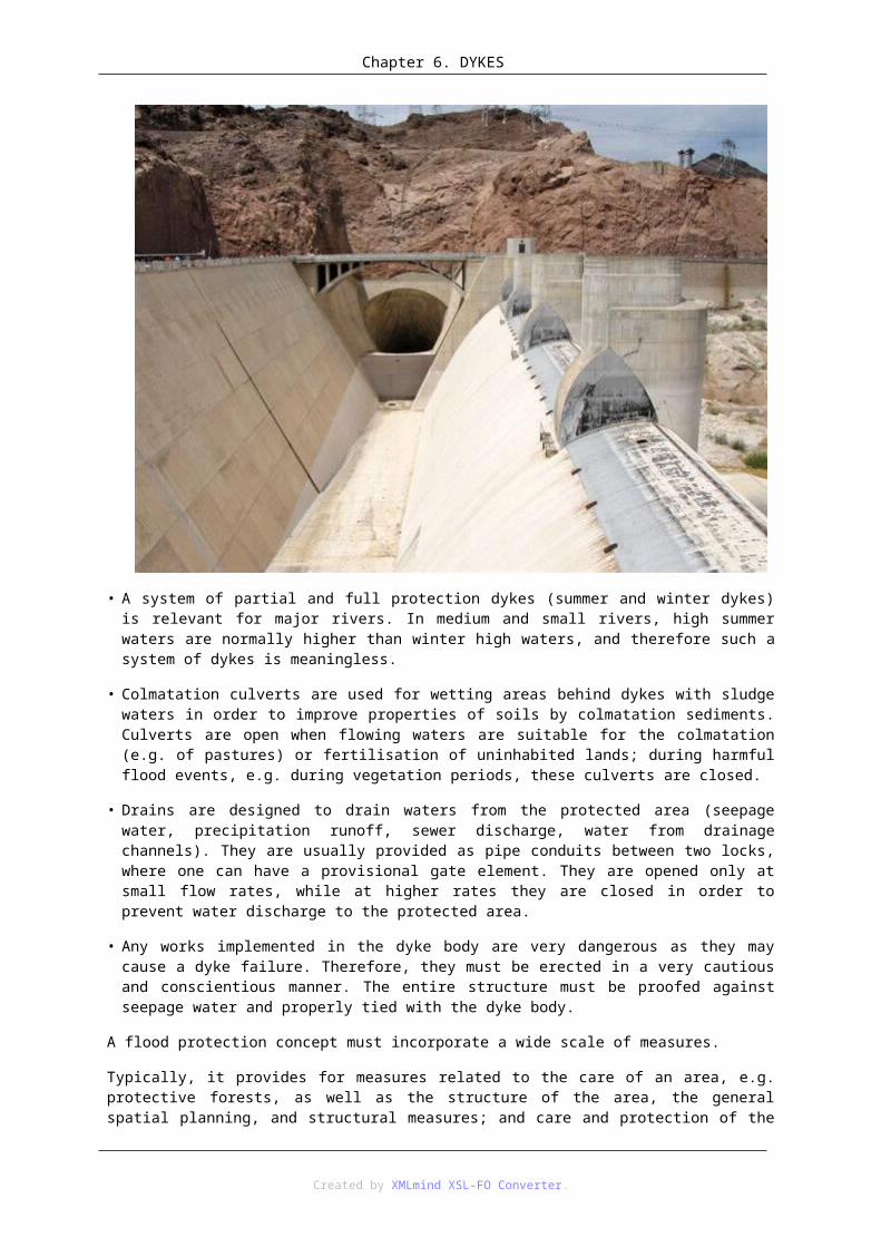
Chapter 7. WETLANDS
Wetlands may contribute in various ways to the realization of the basic purposes of the water management, i.e. the maintenance of the good water condition, the balanced supply of the users with water and the protection against floods. The following are the most frequently mentioned functions of bogs:
• retention of overflow waters,
• retention of precipitations and supply of lower-lying water-bearing strata,
• immobilizing of biogenic substances,
• immobilizing of substances toxic for fish and crustaceans.
Retention of overflow waters only takes place in wetlands of a fluviogenous type. Their capabilities of functioning in this respect become reduced in the case of river regulation, especially after the introduction of embankments. It may be assumed that regulatory works and embankments reduced the retention of valleys of large rivers in Europe by 40% to 80%. The fulfilment of flood control functions by bog ecosystems is therefore strictly associated with the maintenance or restoration of the natural condition of fluviogenous wetlands.
The possibility to retain precipitation or thaw water in wetlands depends on the physical properties of soil formations. The highest water capacity belongs to peat soils, especially sphagnum moss peat. In connection with the phenomenon of the increasing capacity of the deposit in the case of the raising of the level of ground waters referred to as pulsatory retention, the capability of the deposits of sedge and moss peats and moss peats to retain water may be significant locally. As it was evidenced above, the majority of water is consequently used in the process of evapotranspiration. The supply of rivers, especially underground waters from this type of areas, is small due to the low hydroconductivity of the organic bed or the waterproof floor of the mineral layer which allows for the maintenance of retention.
The scrutiny of the usefulness o wetlands in the management of water resources as well as the planning of protective actions concerning the water supply of bog areas should, in the author’s opinion, be conducted at the stage of the establishing (or verifying) the plans of the water management in a reception basin. Assuming, according to the guidelines of the Water Framework Directive, four phases of the creation of the water management plans in a reception basin, i.e. the determination of water resources and demands of water users, the identification of the basic problem of water management, the selection of improving actions and the execution of the plan and monitoring, the analysis of the condition of wetlands at every stage in a manner presented in Fig. 17 is suggested.
Created by XMLmind XSL-FO Converter.

Chapter 7. WETLANDS
In the phase of the determination of the condition of water resources and demands whose task is to make an inventory of all the basic elements of a reception basin, one should identify wetlands occurring in a reception basin and determine their sources of supply, i.e. identify the type of a hydrologic supply.
In the phase of the identification of the basic problems of water management in which the condition of water supply of individual users is determined and areas in which water is a factor delimiting the development are identified, the basic natural studies in wetlands should take place to determine their condition, especially to scrutinize whether the current water conditions are a factor leading to potential degradation of the quality of the bog ecosystems of a habitat. In order to define the rules of water management, it is crucial to differentiate between the protective status and the requirement of partial of complete renaturalization of water conditions of a wetland.
Created by XMLmind XSL-FO Converter.

Chapter 7. WETLANDS
In the face of a specific role played by wetlands in a reception basin, i.e. simultaneously of a water user and a component shaping the quality and quantity of water resources, the identification of the role of wetlands in the improvement of the condition of water resources is vital as it is both a component of the identification of the basic problems and one of the alternative activities in the process of the selection of improving actions. The key issue in this action is to determine whether the activities of bog ecosystems as specific service providers do not lead to the reduction of natural values of the analysed ecosystem. An example is the use of wetlands for the removal of biogenic substances from water environment, which may lead to excessive eutrophication of an ecosystem. If so, is this profitable from the point of view of all the purposes of water management in a reception basin? Depending on the decision, the desired water levels in a wetland will correspond to those which are optimal due to the protection of natural values or will be modified in such a way that will fulfil other tasks.
The phase of the selection of improving actions encompasses the confrontation of water demands of individual users with available resources. The gist of the integrated management is the minimization of social, economic and natural losses induced by water shortage. Obviously, in the case of water shortage, hierarchization of users occurs and the supply with water of “more important” users takes place at the expense of users placed lower in the hierarchy. The gist of the rationalization of the protection of wetlands in the scope of the planning of water management in a reception basin is to include water demands in the decision-making process and the possibility to forecast the consequences of the limited supply with water in order to compare them with losses induced by water shortage in other users. This may be achieved through modelling or identification of appropriate hydrologic characteristics. Obviously, the use of models (especially mechanistic ones) is a solution which fully allows for the determination of consequences of not supplying water to individual users which leads to the rationalisation of the processes of the selection of actions in the area of a reception basin concerning the allocation of water among individual users.
In decision-making processes concerning water management, a dilemma how to provide a society with good-quality water without simultaneous degradation of water environment and water-dependent land ecosystems plays a more and more important role. Wetlands as a water user who significantly modifies the quantity and quality of water become a crucial component of the solution to the dilemma.
3. ReferencesINGRAM H.A.P., 1983: Hydrology [w:] Ecosystems of the world. A.J.P. Gore (ed.). Vol. 4A: Mires: Swamp, Bog, Fen and Moor. Elsevier, Amsterdam: 67-158.
IVANOV K.E., 1975: Vodoobmen v bolotnykh landshaftakh. Gidrometeoizdat, Leningrad: 1-280.
MALTBY E., HOGAN D.V., IMMIRZI C.P., TELLAM J.H., PEIL M.J., 1994: Building a new approach to the investigation and assessment of wetland ecosystem functioning. [w:] Global Wetlands: Old World and New. Mitsch W.J. (ed.). Elsevier. Amsterdam: 637-658.
OKRUSZKO H. 1992, Siedliska hydrogeniczne, ich specyfika i zróżnicowanie. Bibl. Wiad. IMUiZ, 79, str. 5 – 14.
OKRUSZKO H., 1964: Czynniki hydrologiczne jako podstawa podziału torfowisk. Wiad. IMUZ 4 (2): 147-164.
Created by XMLmind XSL-FO Converter.