the economics of . waler supplyageconsearch.umn.edu/bitstream/229146/2/iaae-ijaa-v-1-5...blue nile...
TRANSCRIPT

.. . INTERNATIONAL
• JOURNAL. OF AGRARIAN AFFAIRS
~ . Vol. III, No. I, January 1961
.. The Economics of ii.-
: . Waler Supply ~ and Control: .. .. , ...
..
..
.. .. .. .,,
..
..
..
..
Canada
Egypt Denmarli.
Price Ss. Od. net
OXFORD UNIVERSITY PRESS LONDON
0

BJ A. A. EL TONBARY and
M. S. ABOU_ EL EZZ • University of Ain Shams and University of Cairo
•
,.
ECONOMICS OF WATER SUPPLY AND CONTROL
IN THE SOUTHERN REGION OF THE
UNITED ARAB REPUBLIC : AN OUTLINE
Introduction
I T is common know ledge that water exceeds every resource other than air in the urgency with which it is required and in the quantity
used. So varied and so vital are the purposes for which it is needed that several fields of technical and social sciences are concerned with its provision in a safe form and in abundant and continuous quantities. In a country such as Egypt, with an arid or semi-arid type of climate, water is an element of paramount importance in determining the limits of settlement, the use of land and the extension of the area that can be brought under cultivation, apart from its influence on agricultural production. The Nile-the 'Hapi' or beneficent god of the ancient Egyptians-provided the land with an abundant, continuous and safe supply of water which has been the mainstay of a developed civilization since the dawn of history. The Nile in point of fact may be called an exotic stream since it rises in rainy areas beyond the arid boundaries of Egypt and flows northwards across dry lands thus turning its valley into a huge linear desert oasis. Egypt is little more than this linear oasis which sustains the bulk of its population. It is but natural therefore that the riverside inhabitants should have mastered since time immemorial the techniques of water control. The object of this paper is to outline the contribution of the main sources of water in Egypt to the country's agricultural economy. It may be of considerable interest also to study the systems of irrigation and drainage and to assess the benefits they have made possible. Even before doing that it may be desirable to define irrigation itself. It is, of course, the artificial process of supplying water to crops in countries where rainfall is either insufficient for the purposes of cultivation or comes at the wrong season for their cultivation. r
1 H. Brown, Irrigation, p. r, Constable, London, 1907.

16 THE ECONOMICS OF WATER SUPPLY AND CONTROL
Two systems of watering are found in Egypt, namely, the natural system of rainfall and the artificial system of basin and perennial irrigation, of which the latter is dominant. Three main sources of water supply can be distinguished, namely, rainfall, Nile water and underground water. 1
Rainfall (natural system of watering)
Rainfall is the primary source of all water supplies, although it is very scarce in Egypt, and is almost negligible as a controlling factor in Egyptian agriculture, the area dependent mainly on rainfall being but a very small fraction of the total area under cultivation. This is practically confined to the region bordering the Mediterranean. The average rainfall does not exceed 200 mm. annually (about 8 inches) and .the recorded amounts have never exceeded 400 mm. 2 The amount of rainfall is highest along the coast, particularly in the stretch between Alexandria and Borollos which is the most northerly tip of the Delta and where the annual amount averages 190 rrim. 3 This is attributed to the fact that the Borollos sector of the coast lies nearest to the paths of Mediterranean depressions. Eastwards from Borollos the rainfall diminishes considerably until it averages 80 mm. at Port Said-less than 50 per cent. of that at Alexandria. In the semi-desert strip west of Alexandria the mean annual rainfall is 130 mm. Here the coast recedes to the south in Arabs Gulf, but farther west, near Mersa Matruh where the. coast once again bulges to the north, the rainfall increases to about 150 mm. a year. The amount of precipitation also decreases as one proceeds southwards from the coast, giving the Delta a lesser amount than the littoral. In the Delta, however, rainfall is generally heavier in the western part than in its eastern provinces in the same latitude, owing to the decreasing effect of the moisture-bearing north-westerly winds as they cross the land. ,
The comparatively small amount of rainfall in the northern margin of Egypt is very effective, however, for it falls almost entirely within the six months of winter (October to March), 90 per cent. falling between December and February. Thus the inhabitants of the Maryut region to the west of Alexandria, in particular, are able to raise some crops, mainly barley, in years of reasonable rainfall. The
1 A. A. El Tonbary, Fundamentals of Egyptian Agriculture, 3rd ed., vol. i, chap. 5, Shoubra Press, Cairo, 1947. (In Aiabic.)
-2 L. J. Sutton, Rainfall in Egypt, Govt. Press, Cairo, 1949. 3 Over the thirty-five years since observations began in 1912.
•
...
..

•
•
A. A. EL TONBARY AND M. S. ABOU EL EZZ 17
landscape during the winter becomes a mosaic of cultivated patches sporadically distributed among rocky outcrops and ridges. Primitive methods of cultivation are adopted by the Bedouin, and as a rule very light ploughing of the soil, and the sowing of seed takes place early in September, before the rainy season. The first showers of winter (in late October or November) germinate the seed, but subsequently the plants are dependent upon the frequency and intensity of the precarious winter rains. Hoeing, weeding or manuring are rarely done. The shallow ploughing of the soil tends to make it cake and harden, and much of the rain which falls evaporates from the surface. Dry farming is not practised except in a few places near Alexandria. This process entails loosening the soil to a depth of 50 cm. to enable the rains to sink in. Thus the subsoil water-level rises, and plants such as barley, vegetables and fruits (melons, figs, grapes and olives) are able to draw on a greater store of water, giving them a better chance of maturity. I_n Greco-Roman times the Maryut region westwards to Cyrenaica was very productive. It was cultivated by a sygtem of dry farming in combination with numerous wells and cisterns, many of which still remain. After the eleventh century the region began to decline in importance through neglect, misuse and the diversion of energy to more easily cultivable areas.
Dry farming operations on modern lines such as those carried out by the Italians in Tripolitania were put into practice near Bahig (30 km. south-west of Alexandria) from 1917 to 1919. Under these conditions the olive tree offers the greatest hope, though it begins to bear fruit only after seven years. Rainfall could not be relied on entirely because of the relatively large annual variations, which necessitate the use of subsoil water as an additional source during relatively dry winters. The widespread use of windmills which tap the subsoil waters might provide a convenient solution to this problem. In most of the last twelve years the rains have been deficient and the crops poor. In addition, the crops are occasionally seriously damaged by heavy storms. Consequently it has been necessary to supply the local population with grain from elsewhere. The present government has taken wide steps in this direction.
A second aspect of the economic value of rainfall is to be found in the sand dunes which fringe many parts of the northern coast, the depressions forming natural reservoirs. The accumulated water is exploited in many areas that lie in the hollows between the sand dunes, as in northern Sinai and in the Borollos district (Baltim).
B 9289 c

18 THE ECONOMICS OF WATER SUPPLY AND CONTROL
Nile Water
Although the Nile is the main source of water, it is not the only source. Since the early stages of Egyptian civilization the riverside inhabitants have relied on underground water for maturing certain crops and growing others during the late winter and summer. Under present-day conditions underground water contributes only a small portion of the water supply of the country; but there are great prospects for its exploitation as an additional source, especially in the depressions in the western desert.
The average annual discharge of the Nile at Aswan is 84 milliard cubic metres. 1 The Lake Plateau contributes 16 per cent., the Sobat
TABLE r. Cultivated land by system of irrigation in Egypt, I957 (in thousand feddans)
Irrigation system Lower Egypt Upper Egypt
Perennial irrigation 3,907 1,458 Combined
" 374 Basin
" 608
Nili " I7
(Berm lands)
Total 3,907 2.457
Ministry of Public Works, Cairo, personal communication. A. Hashem and H. El Sherbini, Irrigation Works in Egypt,
vol. i, Govt. Press, Cairo, 1957, p. 5 r.
l 5 per cent. and both the Blue Nile and Atbara cg_ntribute 69 per cent. (56 and 13 per cent. respectively). 2 It can be seen, therefore, that the Blue Nile and Atbara provide Egypt with more than two-thirds of its water requirements.
It is estimated that the irrigation requirements of the total cultivated area in Egypt amount to 48 milliard cubic metres. 3 The total area that can be brought under cultivation is estimated at 7·8 million feddans ( l feddan = l ·038 acre )4 (which slightly exceeds 3 per cent. of the total area of Egypt), including about half a million feddans in the salt marshes of the northern part of the Delta. 5 Out of this total 6·3 million feddans are under the plough: 3 ·9 million feddans in Lower Egypt and 2·4 million feddans in Upper Egypt (Table 1). It
1 A. Hashem and H. El Sherbini, Irrigation Works in Egypt, Govt. Press, Cairo, 1958, vol. ii, p. 3. (In Arabic.) ' 2 H. E. Hurst, The Nile, London, 1952, p. 24r.
3 Report on Sadd El Aali Project, lmprimerie Misr, Feb. 1955, p. 5. 4 This total can be increased to 10 million feddans provided that water can be lifted up
to 20 metres. Ministry of Public ·works, Experts' report on major irrigation projects, Govt. Press, Cairo, 1950, p. 23. 5 A. Hashem and H. El Sherbini, op. cit., vol. i, p. 48.
..
...
••
...

•
A. A. EL TONBARY AND M. S. ABOU EL EZZ 19
is inevitable, therefore, that in order fully to exploit the arable land of the country there is no alternative to the artificial control of the Nile waters.
A. Basin irrigation system
It is probable that the earliest form of watering from rivers was a natural one brought about by the rivers overflowing the lands bordering their lower reaches. In Egypt this natural inundation was assisted and controlled successfully by artificial banks and methods of regulation, and was known as the basin system. It was under this system that Egypt attained a pinnacle of civilization during the Pharaohs of the old dynasties and that, in the time of 'Joseph the Prophet', the neighbouring countries came into Egypt to buy corn. The climate, the turbidity of the Nile flood and the formation of the flood plain have all rendered the basin system of irrigation the most suitable for this area since time immemorial. If the flood had been early in April and May followed by a burning summer as is the case in Iraq, 1 basin irrigation would have been a failure. But the Egyptian climate and the annual late summer inundation, allowing time for the maturing of a winter crop sown after the subsidence of the flood, have maintained basin irrigation without rival for 7,000 years. 2
It wasJhe left bank of the river which was first reclaimed and prepared for basin irrigation during the reign of King Menes. A longitudinal dike was run parallel to the river and a number of cross-dikes tied it to the Libyan desert. Flood waters were led into the basins between these dykes by· natural water courses and artificial canals, wherein the flood waters were retained for fifty days to allow the deposition of mud and a thorough saturation of the soil. After the filling process (August to October) the flood waters were allowed to run back to the river through an escape at the tail of the northern basin. Within three weeks of the completion of the filling process the emptying of basins took place (October to November). The land then became ready for sowing. Afterwards, crops were left until ripe for harvest.
The Pharaohs of the 12th dynasty repeated on the right bank what King Menes had done on the left.
The basin system of irrigation with its annual single crop (in 1 The flood of the Euphrates and Tigris occur during April when the ice formed on the
Armenian plateau during the winter begins to thaw. /
2 W. Willcocks and J. I. Craig, Egyptian Irrigation, 3rd ed., vol. i, p. 299, 1913.

20 THE ECONOMICS OF WATER SUPPLY AND CONTROL
winter) continued over the country from the time of the Pharaohs to the second decade of the nineteenth century when Mohamed Aly introduced perennial irrigation in Lower Egypt. But wherever the subsoil gave a plentiful supply of water, intensive cultivation was permitted throughout the year, and at such places the ancient important cities of Thebes, El Kab, Syene (Aswan) and Edfu flourished. Underground water therefore represents the link between perennial and basin irrigation.
It should be mentioned that in order to arrange properly for the supply of water to a basin system two principles need to be observed. First, in a year of low flood the supply should be distributed in such a quantity and at such a level that the whole area of the chain of basins may be sufficiently inundated during the time allowed, so- that the winter crops sown after the flood will mature without further irriga-
TABLE 2. Basin area by system of irrigation, Upper Egypt, I958
Irrigation system
Land irrigated by basin system ,, cereal project
Total
(combined system) ,, combined system ,, pumping stations ,, Nili system
Area in feddans
590,800
257,500 I 14,200 145,000
I I ,OOO
I, I 18,500
R. A. Soliman, The conversion of basin irrigation into the perennial system, Ministry of Public Works, Cairo,
1959, p. 10. (In Arabic.)
tion. Thus the cost of raising crops may be lessened. Secondly, the deposited mud which the river brings down in suspension from its sources should be as abundant as possible and should also be evenly distributed over the basins of the chain, thus cutting down costs of fertilizers.
The observance of these two principles has been secured on the elaborately developed basin system by arrangements of canals and banks to suit the proper filling and emptying operations in the basin chain. This old system is still to be found in Upper Egypt on approximately 600,000 feddans (Table 2). But this does not necessarily mean that only a single crop can be raised, as some farmers are able to grow summer crops when underground water is available.
It is the intention of the government to convert basin irrigation in Upper Egypt to the perennial system by the end of 1964, which marks
•

A. A. EL TONBARY AND M. S. ABOU EL EZZ , 21
the completion of the first stage of the High Dam. It is expected that the capital expenditure for the conversion will amount to £E41 million, inclusive of drainage projects. Such conversion would enable farmers to increase the value of farm output by £E.8·3 million1
annually. (This does not include the expected increase in land values. )2
B. Perennial irrigation
Perennial irrigation was made possible through the excavation of canals which run the whole year round, as distinct from canals in basin irrigation which run only during flood. The construction of the
TABLE 3. Total cultivated area and total crop area in Egypt during the period I897-I957 (in thousandfeddans)
Total cultivated Index Index Year area no. Total crop area no.
1897 5,047 100 6,764 100 1907 5,403 107 7,662 113 1917 5,319 105 7,686 114 1927 5,544 IIO 8,661 128 1937 5,281 105 8,358 124 1947 5,761 114 9,167 136 1957 5,717 113 10,055 149
Delta Barrage in 1865 was the turning-point, since it raised the level of the Nile water up stream by approximately 14 metres, thus enabling substantial irrigation canals to take from it. Consequently the total cultivated area increased from 5·047 million feddans in 1897 to 5·717 in 1957 (Table 3). 3 The perennial system was also applied to a considerable area of Lower Egypt with a notable increase in the summer crop area from only 250,000 feddans before 1872 to l,200,000 in the last decade of the nineteenth century. 4 This had obviously a pronounced effect on the national agricultural income. Gradually perennial irrigation was introduced up stream of the barrage in the Nile valley proper. This was carried out through the construction of other barrages such as the Asiut Barrage (1902), the Esna Barrage (1908)
1 The average increase in income per feddan amounts to £E.12·6 estimated at constant prices, where the same pattern of production is practised.
2 S. Mansour and B. El Mankabadi, Economic results from converting basin irrigation areas to the perennial system, National Planning Commission, Cairo, Nov. 1958. (In Arabic.)
3 Y. Milad, Trends in expansion of agricultural production in Egypt, part i, p. 2. National Planning Commission, Cairo, 1958. (In Arabic.)
4 W. Wilcocks and J. I. Craig, op. cit., pp. 311-26.

22 THE ECONOMICS OF WATER SUPPLY AND CONTROL
and the Naga-Hammadi Barrage (1930). All these projects helped to ensure a better control of the Nile water supply.
Prior to the introduction of perennial irrigation in Lower Egypt, summer irrigation was practised over only 12 per cent. of the total area of the Nile Delta. In 1874, 250,000 feddans in the provinces of BeniSuef and Minia were converted to perennial irrigation through the excavation of the grand lbrahimia Canal along the left bank of the river. The Fayoum depression also came under the perennial system through the diversion of the take-off of Bahr Youssef from the Nile to the above-mentioned lbrahimia Canal. Consequently the basin irrigation area diminished to 1, 7 50,000 whilst the area under the perennial system increased to 3,500,000 feddans. 1
On the completion of the Aswan Reservoir in 1902, a beginning was made with the conversion to perennial irrigation of 400,000 feddans of basin lands in Minia, Beni-Suef and Giza Provinces, thus increasing the total perennial area to 4,064,000 feddans. The basin areas decreased meanwhile to 1,287,000 feddans, 18 per cent. of which represented the high patches of land along the river banks which were irrigated by lift. 2
The Aswan Dam (1902) was built at first to hold up water to a level of 114 metres above sea-level. In 1912-13 the first heightening was executed, increasing the capacity from 1 milliard cubic metres to 2·4 millions. A second heightening to 121 metres was made in 1933, with an increase in capacity to 5 milliard cubic metres. It reduced the total basin area to only 900,000 feddans, three-quarters of which were on the left bank of the river, particularly in Quena and Sohag provinces. At present, the basin area is approximately 700,000 feddans (see Table 2).
In Lower Egypt, the Zifta Barrage on the Damietta branch of the Delta was built in 1903 with the object of increasing the capacity of the irrigation canals and providing the northern parts of the Delta with their full requirements of water, particularly before the arrival of flood waters. In 1939 the Delta Barrage was reconstructed to hold up water at a higher level. Also, in 1951, Edfina Barrage (near the debouchment of the Rosetta branch of the Delta) was constructed for the purpose of obstructing the southward ingression of sea waters and also for watering the surrounding lands.
Gebel Aulia Dam ( 1937) was built in an attempt to increase the total storage capacity to 7· 5 milliard cubic metres. However, the capacity
1 W. Wilcocks and J. I. Craig, op. cit., p. 316. 2 Ibid., p. 325.

A. A. EL TONBARY AND M. S. ABOU EL EZZ 23
of the reservoir is 3 milliard cubic metres of which only 2·5 milliards reach Aswan.
The benefits ensured through the construction of both Aswan and Gebel Aulia dams were as follows:
1. The regulation of water distribution into the fields through an elaborate system of irrigation rotations set under governmental superv1s10n.
2. An early process of 'Tafy El Sharaki' 1 which enables a timely sowing of maize and rice.
3. The cultivation of a minimum of 200,000 feddans of rice annually.
4. The possibility of converting some basin areas in Upper Egypt to the perennial system of irrigation.
5. The expansion of reclamation programmes as a result of improving water control.
TABLE 4. Cultivated land .irrigated by free flow and. by lift in Egypt, r957 (in thousand feddans)
Cultivated land by
Location free flow lift Total
Lower Egypt 423 3,484 3,907 Upper Egypt 1,190 . 321 l,SII Basin area 946
l,613 3,805 6,364
Ministry of Public Works, Cairo, personal communication.
Another classification of irrigation is by free fl.ow and by lift, which represent 60 and 25 per cent. of the cultivated area respectively (Table 4). The first procedure has been made feasible through a series of barrages and irrigation canals. The second is carried out either by engines and pumps2 or by some rudimentary lifting devices such as the water-wheels, the tambour (Archimedean screw) and the shadouf, wherever the level of the land is higher than that of water in the irrigation canals.
1 A watering given to the land after the harvest of winter crops in June and early July before ploughing and sowing. The water needs of the parching lands at this time of the year are immense, the average being about 700 cubic metres per feddan.
2 From 1907 onwards the government has constructed several pumping stations such as Amyria Station near Cairo (1907), Abou El-Menagga in Qaluibia Province (1932), Maghagha in Minya Province (1931) and El-Gharaq in Fayoum Province (1942).

24 THE ECONOMICS OF WATER SUPPLY AND CONTROL
The most common devices used for lifting water under Egyptian farming conditions are given in Table 5. Portable or stationary engines and centrifugal pumps are often used on medium and large farms when the lift is above 3 metres. The main advantage of pumping is that irrigation can be carried out at a fairly reasonable cost.
The tambour and the shadouf are worked by men and are commonly used on small farms for lifts of ! to zt metres. The animaldriven sakia el baladi, tabout and tambousha are often used for lifts of up to 8, 3 and zt metres respectively. The cost of irrigation by
TABLE 5. Common devices used for lifting water
Maximum Av.fed. Area* lift in irrigated allotted
Device metres daily to a device Cost of working per day
Shadouf 2! t >I fed. Lab. cost of 2 men+D. Tambour .a I-2 5 Lab. cost of 4 men+D. 4
Saqia El Baladi 8 t-1 5 {Power costt + Lab. Ta bout 3 I-2 IO cost of a man and a Tambousha 2! 3-5 25 boy+D. Undershot wheel
I 4! 2 IO Lab. cost of a man+D.
Engines and pumps <3 variable variable Variable.
* An area for which a device is considered capable of irrigating during a given rotation. t Charge for one or two pairs of animals. D = cost of depreciation.
A. A. El Tonbary, op. cit., chap. 6.
the use of tambour and tambousha is less than by any other rudimentary device.
In some localities such as in Aswan province, 1 electric stations were erected for the purpose of transmitting electricity to the pumping stations. Some pumping stations, however, are driven by plant waste or oil.
Before turning to another point it should be mentioned that spraying (in which the soil surface is wetted much as by rainfall) has been applied as a method of irrigation in some areas such as the Tahrir Province and the Anshas estate, with a view to making the most effective use of the Nile water and to cutting down the expenses of reclamation. As this experiment is still in its early stages it is probably too soon to say whether or not such a method of irrigation has much practical application under Egyptian farming conditions.
Amongst the most important advantages of perennial irrigation in Egypt has been the possibility of producing an average of two crops
1 A powerful electric station (El-Atwani) was constructed here in 1933.
••
•
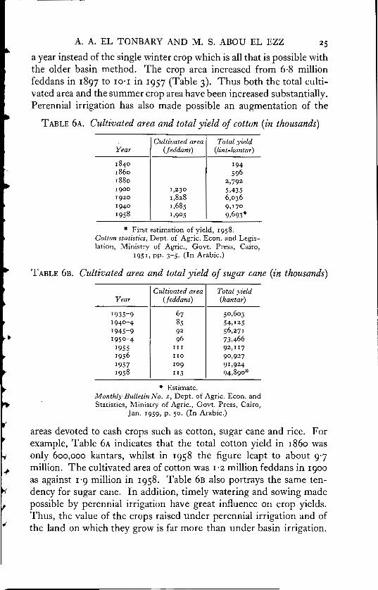
A. A. EL TONBARY AND M. S. ABOU EL EZZ 25
a year instead of the single winter crop which is all that is possible with the older basin method. The crop area increased from 6·8 million feddans in 1897 to 10·1 in 1957 (Table 3). Thus both the total cultivated area and the summer crop area have been increased substantially. Perennial irrigation has also made possible an augmentation of the
TABLE 6A. Cultivated area and total yield of cotton (in thousands)
Year
1840 1860 1880 1900 1920 1940 1958
Cultivated area (.feddans)
l,230 l,828 l,685 l,905
Total yield (lint-kantar)
194 596
2,792 5,435 6,036 9,170 9,693*
" First estimation of yield, 1958. Cotton statistics, Dept. of Agric. Econ. and Legislation, Ministry of Agric., Govt. Press, Cairo,
195 l, pp. 3-5. (In Arabic.)
TABLE 6B. Cultivated area and total yield of sugar cane (in thousands)
I Cultivated area Total yield Year (feddans) (kantar)
1935-9 67 50,603 1940-4 85 54,125 1945-9 92 56,271 1950-4 96 73,466
1955 II l 92,rr7 1956 110 90,927 1957 109 91,924 1958 rr3 94,890*
" Estimate. Monthly Bulletin No. I, Dept. of Agric. Econ. and Statistics, Ministry of Agric., Govt. Press, Cairo,
Jan. 1959, p. 50. (In Arabic.)
areas devoted to cash crops such as cotton, sugar cane and rice. For example, Table 6A indicates that the total cotton yield in 1860 was only 600,000 kantars, whilst in 1958 the figure leapt to about 9·7 million. The cultivated area of cotton was l ·2 million feddans in 1900 as against 1'9 million in 1958. Table 6B also portrays the same tendency for sugar cane. In addition, timely watering and sowing made possible by perennial irrigation have great influence on crop yields. Thus, the value of the crops raised under perennial irrigation and of the land on which they grow is far more than under basin irrigation.

26 THE ECONOMICS OF WATER SUPPLY AND CONTROL
The increase in value of crops under perennial irrigation accounts for a higher rental value per f eddan.
The possibility of land reclamation under perennial irrigation led to an increase in the total cultivated area. As shown in Table 7 the
TABLE 7. Land reclaimed during the period I930-44 (in thousand feddans)
CultivatPd land
Location 1930 1944 Land reclaimed
East of Delta I,3 IO 1,391 81 Centre of Delta 1,387 1,489 102 ·west of Delta 677 712 35
Total 3,374 3,592 218
A. Hashem and H. El Sherbini, op. cit., vol. i, p. 48.
total area brought under cultivation by reclamation during the period 1930-44 amounted to 217,700 feddans. On the other hand, perennial irrigation has been accompanied by a marked deterioration of soil fertility owing to (i) the rise of the subsoil water-level; (ii) depriving
TABLE 8. Total consumption off ertilizers (home production and imports) during the period I9J0-57 (in thousand tons)
Home production Imports
Year Nitrates Superphosphate Nitrates Superphosphate Total
1930 .. . . 272 45 317 1935 . . .. 481 81 562 1939 .. 20 432 40 492 1940 .. I2 351 7 370 1945 . . 17 261 .. 278 1950 .. 69 598 43 710 1955 191 137 452 .. 780 1957 208 182 620 .. 1,010
Development of industries in Egypt during the past twenty years, National Planning Commission, Cairo, May 1958. (In Arabic.)
the cultivated areas of the replenishment of their fertility by seasonally deposited slime; (iii) the exhaustion of the soil through multi-cropping -a practice which does not allow fallowing to the same extent as the ~ old traditional rotation of the basin system. This has given rise to an increase in the use of fertilizers, thus entailing higher farm costs. It is also reflected in Egypt's total consumption1 of fertilizers as illustrated in Table 8.
' i.e. the total home production together with the total imports.

A. A. EL TONBARY AND M. S. ABOU EL EZZ 27
It might also be of interest to mention that the submergence of the cultivated tracts during a considerable length of time each year (particularly in Lower Egypt) has caused the spread amongst the peasants of parasitic diseases such as bilharzia and malaria, all of which have a marked effect on labour efficiency.
The High Dam
Aswan, Gebel Aulia reservoirs and the other Nile water-control projects were, however, far from complying with the country's demands. The High Dam project thus came to the fore with a huge capacity of 130 milliard cubic metres. The live storage that could be ensured by the Dam is 70 milliards after allowing for flood protection and silting processes, i.e. fourteen times that of the Aswan Dam.
The High Dam will permit the maximum possible utilization of flood water reaching Egypt which now pours into the Mediterranean. In general it will make possible the control of Nile water for irrigation, flood protection, navigation, power and other purposes. Its main advantages can be briefly summarized as follows: 1
(i) Ensuring a sufficient supply of water for the existing lands under cultivation even in years of low supply.
(ii) Providing additional supplies of water for a programme of agricultural expansion which entails adding 1 ·3 million feddans to the total cultivated area (equivalent to one-fourth of the present total), of which 0·9 million will be in Lower Egypt (Tahrir Province, Salihia Desert and elsewhere) and 0·4 million in Upp er Egypt.
(iii) Allowing for the conversion of 700,000 feddans in Upper Egypt from basin to perennial irrigation with a considerable increase in the crop area.
(iv) Guaranteeing the cultivation of at least 700,000 feddans of rice annually, irrespective of the amount of Nile water in flow, thus avoiding the present fluctuations in rice output.
(v) Enabling the generation of electricity which could power irrigation and drainage pumps at low cost. The generated power will of course also be used for other industrial purposes.
(vi) Saving expense by preventing high floods. (vii) Reducing the underground water table during the flood period,
" 1 M. A. Selim and A. A. Farag, 'The Economic Results of the High Dam', Agri
cultural Magazine, vol. i, No. z, Dec. 1958, pp. 8-16.
28 THE ECONOMICS OF WATER SUPPLY AND CONTROL
thus improving drainage conditions and facilitating the free drainage of land in Upper Egypt.
(viii) Improving navigation throughout the year.
The High Dam project, on the other hand, will cause the submergence of about 22,000 feddans of cultivated lands owing to the formation of a huge elongated lake which will extend southwards for more than 350 kilometres. This lake will inundate a considerable area of cultivated patches along the river in the south of Egypt and1 in the northern province of the Republic of Sudan. The Egyptian Government will have to pay indemnities to the proprietors of these tracts. New schemes for rehabilitation of the Egyptian Nubians whose lands will be flooded are under consideration, and appropriate sites have been selected down stream, in the northern part of Aswan province.
The High Dam, which is solid, having no sluice gates for the discharge of flood waters, will be subject to silting up stream which will as time passes reduce the storage capacity. At both banks of the artificial elongated lake, bays and creeks will project to considerable distances and may add to the loss of water.
Since the process of silting-up of the reservoir will proceed year by year, the stored water reaching Egypt proper down stream of the reservoir will be devoid of suspended materials. This may increase the erosive power of the water in addition to depriving the land of rich alluvium.
Also, the number of brick factories is likely to decline as a result of the separation of water from the suspended matter which provides their raw material. Another point is that the Nile fisheries down stream of the reservoir will be affected by the Dam. Accordingly, labour in these two industries is expected to decrease. However, surplus labour can be employed in newly established industries such as the fertilizer and iron and steel industries; and the new lake behind the Dam may replace much of the loss in down-stream fishing. The problems arising from these processes have been taken into consideration and have been proved not seriously to modify the sizeable and widespread economic benefits to be derived from the construction of the Dam.
The direct consequence will be another economic revolution similar to that which followed the introduction of perennial irrigation. Such a revolution will definitely make possible the very much needed redistribution of population and will also provide new opportunities for

...
..
,.
..
..
A. A. EL TONBARY AND M. S. ABOU EL EZZ 29
employment with, possibly, a higher standard of living owing to the increase in national income .
Underground water
Underground water is used for irrigation purposes in many localities, chief amongst which are the great oasis depressions of the western desert. However, it plays only a minor role as a source of irrigation. One may classify for convenience the sources of underground water supplies into the following:
(A) Underground water derived from the Nile. The alluvial deposits which fill the excavated trough known as the Nile Valley form a substantial reservoir for water which percolates laterally from the river itself. The amount of water accumulated in these deposits amounts to thousands of millions of cubic metres. Over 100,000 deep wells tap the subterranean water in both Lower and Upper Egypt (at depths ranging from 20 to 50 metres). 1 The distribution of these wells is concentrated in sporadic and isolated areas on the marginal parts of the Nile Valley and Delta. Generally speaking, the quality of ground water (in terms of degree of salinity) decreases the more one proceeds northwards to the Mediterranean littoral. About So per cent. of well waters are drinkable, and are utilized for irrigation in the localities mentioned above. Possibilities of expansion in this direction are great and may amount to as much as the total area at present under cultivation in these regions.
(B) The eastern desert. Here rainfall is scarce apart from the torrential rains over the Red Sea hills which occasionally fill the channels of the numerous wadis which dissect the surface of the desert. Water could be obtained from wells dug in the valley floors. There are also some springs which supply the drinking needs of the nomads and their flocks. The qulut-which are rock cisterns hollowed through the process of pot-holing by the action of rains-form another source of water . Such cisterns are filled with water after sudden rains. The amount of stored water in them depends on the amount of winter rains, the dimensions of the cisterns themselves, the nature of the underlying rocks and the degree of evaporation. The water supplies of the eastern desert, however, barely suffice for human and animal consumption and are not used for irrigation.
I M. I. Attia, 'Ground vVater in Egypt', Bulletin of the Egyptian Geographical Society, vol. xxvi, Aug. 1953, pp. 207-25. ·
30 THE ECONOMICS OF WATER SUPPLY AND CONTROL
(C) Sinai Peninsula. Most of the ground water supplies originate from the mountainous core in the south, and it is possible to obtain water from wells drilled in the beds of the main wadis, such as Wadi El Tor and Wadi El Arish. Another source of water is in the form of rock cisterns known as Harrabat which are carved in the rocky sides of the wadis. Minor earth dams were constructed across some of the wadis for storing their torrential waters after rainfall. The most important is the Rawafaa Dam near El Arish. The Delta of Wadi El Arish, of over So sq. km., has important reserves of ground water which could be obtained through digging shallow wells.
(D) The western desert. There is a consensus of opinion that there is an unlimited supply of underground water beneath the western desert. It has been established that such a supply has been built up in the Nubian sandstones over hundreds of thousands of years. These sandstones are fed by rainfall over the high mountain ranges of Erdi and Ennedi, thus becoming saturated. The saturated strata, however, dip northwards and become concealed beneath thick layers of more recent sedimentary rocks. Nature, however, has made feasible the tapping of this water, despite its great depth, by excavating huge hollows known as the Egyptian depressions, i.e. Kharga, Dakhla, Frafra, Baharia, Siwa and Qattara depressions.
It has been found that there are two water-bearing sandstone layers alternating with two layers of impervious clays. The upper sandstone layer contains less water than the lower one and its supply is steadily diminishing because of continuous withdrawal for human consumption. It is essential, therefore, to drill deep bores to tap waters from the lower layers for the purpose of increasing the amount of irrigation waters in the depressions.
A new scheme known as El Wadi El Gedid is now being put into operation to increase the cultivated lands of the two oases of Kharga and Dakhla. The preliminary step is to drill deep wells such as the well of Kharga No. 1 (with an annual outflow of 5 million cubic metres) which was sunk in 1956 to a depth of 650 metres. Assuming that rno cubic metres per day can irrigate 5 feddans for five days, the discharge of one well similar to Kharga No. 1 will irrigate 500 feddans at a reasonable cost. 1 Cost of irrigation per feddan is expected to mount to £E.1·66 in Kharga and less than £E.1 in Dakhla, assuming that one well will suffice for irrigating 400 feddans and that the total
1 S. Marei, Agrarian Reform in Egypt, Imprimerie de l'Institut Frarn;:ais d'Archeologie Orientale, Cairo, 1957, p. 316.
..
..
..
'
....
...

..
..
A. A. EL TONBARY AND M. S. ABOU EL EZZ 31
cost of digging one well will be in the region of £E.20,ooo and £E.10,ooo in Kharga and Dakhla respectively. 1
It is not only important but imperative to improve communications with the Nile Valley before embarking on this scheme. Other problems in the oases themselves should be tackled, such as the shortage of capital, the land-tenure system, the neglect of drainage and the rudimentary methods adopted in agriculture. 2
Drainage
The introduction of perennial irrigation has made drainage indispensable to the cultivated lands, since drainage helps soil ventilation, leaches excess salt from the soil, favours the growth of soil bacteria, assures higher soil temperatures, desiccates clay soil, prevents seepage of water, helps to make use of the benefits of inundation (Tanll) and makes possible the cultivation of aqueous plants such as rice. Drainage in Egypt, however, did not coincide with the development of perennial irrigation, so the problem of soil deterioration has become prominent.
Two systems of drainage are adopted in Egypt-natural and artificial. The former, which is dominant in Upper Egypt, entails the free flow of excess water during periods of drought, whilst the second, which is common in Lower Egypt, embraces three procedures: (i) opening channel drains, (ii) using covered tiles of clay or concrete, (iii) pumping ground-water. 3
Open drains irrespective of size and length are used mainly to convey water to distant outlets. Water flows into the open drains directly from the ground water. As a rule, open drains are cut at a lower level than the surrounding cultivated tracts. This is the dominant method of drainage in Egypt.
The use of tile drains is not yet a common procedure in Egypt owing to high cost and difficulty of maintenance, although it saves about 15 per cent. of the cultivated land wasted through cutting open drains. This system entails collecting drainage water from tile lines (usually with a high gradient and at a relatively great depth) and discharging it into the main open drains.
Drainage by means of these two systems is carried out by gravity. The main physical defect of gravity drainage systems is the failure to
1 Irrigation, Drainage and Ground Water Committee Report, National Planning Commission, Cairo, 1959, p. 17. (In Arabic.)
2 S. Marei, op. cit., pp. 316-19. 3 0. W. Israelsen, Irrigation Principles and Practices, John Wiley, London, 1952, p.'.272.

32 THE ECONOMICS OF WATER SUPPLY AND CONTROL
lower the underground water table to a convenient depth. Many gravity drains are shallow and widely spaced. Pumping, therefore, becomes a more effective procedure for lowering the underground water table. This is the universal system of drainage in the Barari of northern Egypt, where the soil is waterlogged owing to its proximity to the Mediterranean. In this remote part of Lower Egypt, three powerful electric drainage pumps were installed (El-Serw, Belqas and El Atf in the north-east, north and north-west of the Delta respectively).1 The Northern Lakes of the Nile Delta form the main outlets for drainage water.
In order to carry out the drainage effectively continuous maintenance of drains (open drains in particular) through dredging and
TABLE 9. Expenditure on dredging during the period r952-7 (in thousands)
Length of water- Expenditure Location courses (kilos) (£E.)
Canals Lower Egypt 26,000 2,200 Upper Egypt 18,000 900
Sub-total 44,000 3,100
Drains Lower Egypt 10,800 930 Upper Egypt 4,800 330
Sub-total 15,600 l,260
Total 59,600
l\!Iinistry Activity in I9 5 2-57 and Quinquennial Programme, Ministry of Public \,Yorks, Misr Society Press, Cairo,
pp. 13-14. (In Arabic.)
weeding must be undertaken. The government spends approximately £E.900,000 2 annually for the maintenance of the main drains and canals (Table 9). The upkeep of the subsidiary channels is left entirely to the landowners and tenant farmers. Dredging and weeding are often carried out in December and January.
The total cultivated area which is favoured with drainage networks represents about 5 r per cent. of the total area under the plough. Upp er Egypt has the greatest area without drains. This is attributed to the
1 These drainage pumps were erected by the government throughout the period from 1928 to 1932. Prior to 1928 drainage was left entirely to individuals to solve through common practices.
2 Total expenses of dredging amount to £E.900,ooo plus £E.400,ooo spent on wages.
..

..
...
..
A. A. EL TONBARY AND M. S. ABOU EL EZZ 33
fact that the cultivated areas in many places are higher than the level of the Nile. The extreme north of the Delta also includes a considerable area without drains. This is why the area without drains constitutes 49 per cent. of the total cultivated area of the Nile Delta, since most of it lies in the 'Barari' of the north, so shown in Table IO.
The present government has put into execution a drainage scheme for 2·1 million feddans in Lower and Upper Egypt. The scheme entails the widening and deepening of the main and branch drains in addition to the construction of drainage pumps to ensure a field-
TABLE IO. Cultivated area with and without drains in r950 (in thousand feddans)
Cultivated Area with Area without Location area drains drains
Lower Egypt 3,357 2,076 l,281
Middle Egypt l,101 642 459 Upper Egypt l,204 142 l,062
Sub-total 2,305 784 l,521
Total 5,662 2,860 2,802
General Agricultural Census, z950, Ministry of Agr., Govt. Press, Cairo, 1958, vol. i, pp. 74--'77· (In Arabic.)
drainage depth of 1·25 metres. Another scheme is planned for the construction of a comprehensive network of drains, including field drains, for 250,000 feddans. Such schemes would lower the underground water table, improving drainage conditions on these areas, and would thus ensure an increase in the national agricultural income.
It should be mentioned in this respect that to encourage the prevalent method of irrigation by lift as an aid to improving drainage conditions is part of the present policy of the Ministry of Public Works, particularly in the newly reclaimed areas.
Drainage water
It is sometimes suggested that drainage water could be utilized for irrigation provided that it is of reasonably low salinity. Such a procedure could be put into practice during the flood season particularly in the northern parts of the Delta where the cultivation of rice, with its need for copious irrigation, is prevalent. The Desert Irrigation Organization is considering at present a project of reclaiming IO,ooo
feddans out of a total of a quarter of a million feddans of arable lands B 9289 D

34 THE ECONOMICS OF WATER SUPPLY AND CONTROL
extending between Alexandria westwards to Alamein. Catering for the water requirements of the project will be made feasible through utilizing the waters of El Omoum Drain which collects all the drainage water of the north-western part of the Delta and empties it into the Mediterranean by means of the powerful El MaX pumps (to the west of Alexandria). The suitability of these waters has been confirmed by laboratory analysis. The project entails cutting an east-west irrigation canal to which drainage waters could be diverted, thus making it possible to irrigate the coastal strip which runs parallel to the Mediterranean.
Conclusion
In no country in the world does water play such a paramount role in every aspect of human life as in Egypt. The economics of the water resources of the land in Egypt govern the distribution of population, the settlement pattern, the basic material needs of the inhabitants and their very existence. The arid climate of Egypt necessitates the full utilization of every drop of water whether this issues from the Nile or through precipitation or from underground sources. Egypt is in point of fact a typical desert oasis and it is but natural, therefore, that its indigenous population should have mastered the techniques of water control since the early stages of their civilization.
If one computes the total capital invested on the main Nile control projects during the period from 1863 to 1959 (Table II) it becomes clear that the enormous capital expenditure was highly justifiable since it has brought about a notable increase in the country's national mcome.
The proper utilization of the water resources in Egypt will undoubtedly have far-reaching effects on its agricultural economy and the pattern of population distribution. To an unusual degree the present pattern of population distribution reflects the extent to which water resources have been controlled. Thus areas of northern Egypt, where water-control projects were neglected for a considerable time, are sparsely populated. The high population density recorded in the provinces located on and around the apex of the Nile Delta coincides to a great extent with the efficient use of water in these areas.
The Maryut region bordering the Mediterranean with its low population density is another example of an area which deteriorated owing to failure to utilize its natural water resources.
The colossal High Dam project will be a starting-point for a new era in Egypt. Important re-locations of population may result from it.
..

A. A. EL TONBARY AND M. S. ABOU EL EZZ 35
These will mainly be ascribed to the expansion of the cultivated area through the reclamation of the Barari of the north and the marginal
• areas of the flood plain. The development of new industrial areas will definitely relieve population pressure on the cultivated areas by ensuring alternative employment to a certain proportion of the farming population, thus facilitating a decrease in the disguised unemployment which already exists in Egyptian agriculture.
~ TABLE 11. Total costs of some irrigation projects during the period I863-I959 (in thousands)
Year of Net benefit Project construction (milliards)
Khayria Barrage 1863 Delta Barrage 1939 Assiut Barrage 1902
reconstruction 1938 Esna Barrage 1908
reconstruction I 1947 Naga-Hammadi Barrage. 1930 Edfina Barrage 1951 Aswan Reservoir 1902 5·0 Gebel Aulia Reservoir 1937 2·5 Owen Reservoir 1954 5·2* Sadd El Aali Reservoir 1959 7o·ot
* This capacity is provided by this dam together with other projects. t Egypt's share of the total cost of the project was £E.4·5 million.
Total costs (£E.)
2,785 2,400
870 1,250
945 3,650 3,705 4,100 9,250 3,500
12,ooot 180,000§
t Net benefit at Aswan after allowances have been made for the silting process and flood protection. J
§ Equals the total costs of the first and second stages of the dam including costs of electricity-generating plant. Other costs connected with the dam such as the power plant, transmission line to Cairo, reclamation of land, conversion from basin to perennial system, and indemnities, amount to £E. 220 millions.
The Nile will also be used for power development. The High Dam will make feasible the installation of a large power plant to add to the power generated at present at the Aswan Dam. Power will give impetus to the agricultural expansion programmes (especially in the parts
• of the flood plain where irrigation by lift is imperative) and also to industrial development such as the production of fertilizers, for which a greater demand is expected after the completion of the High Dam.
The Nile since early history has been the main avenue of interior transportation in Egypt. This is mainly due to its unique characteristics:
(i) Its depth does not fluctuate with the seasons and it is never so shallow as to become incapable of use.
36 THE ECONOMICS OF WATER SUPPLY AND CONTROL
(ii) Its course within Egypt is not impeded by any natural obstacle and it maintains a uniform gradient throughout.
(iii) Up-stream navigation is easy, owing to the prevalence through most of the year of steady north winds.
On the other hand, the stream of the Nile is in the senile stage in Egypt and its meanderings provide a long and indirect transport route. Navigation could be enhanced through the provision of a flotilla of barges capable of transporting heavy and bulky loads with little expenditure of energy and capital. This is essential especially because the riverside inhabitants in most cases congregate in big agglomerated settlements along the banks.