+ model article in press - uni trier · pdf filea,⁎, christoph schneiderb, johannes kochc,...
TRANSCRIPT

1
2
3
4
5
6
7
8
9
10
11
12
13
14
15
16171819202122232425262728293031
3233
34
e xx (2006) xxx–xxx
+ MODEL
GLOBAL-01209; No of Pages 18
www.elsevier.com/locate/gloplacha
ARTICLE IN PRESS
Global and Planetary Chang
PROO
F
Palaeoecological constraints on late Glacial and Holoceneice retreat in the Southern Andes (53°S)
Rolf Kilian a,⁎, Christoph Schneider b, Johannes Koch c, Martinus Fesq-Martin a,Harald Biester d, Gino Casassa e, Marcelo Arévalo f, Gert Wendt g,
Oscar Baeza a, Jan Behrmann h
a Lehrstuhl für Geologie, Fachbereich VI, Geowissenschaften, Universität Trier, D-54286 Trier, Germanyb Institut für Physische Geographie, Universität Freiburg, Werderring 4, D-79085 Freiburg, Germany
c Department of Earth Sciences, Simon Fraser University, Burnaby, B.C., Canada V5A 1S6d Institut für Umweltgeochemie, Universität Heidelberg, INF 236, D-69120 Heidelberg, Germany
e Centro de Estudios Cientificos, Valdivia, Chilef Instituto Antarctico, Universidad Magallanes, Punta Arenas, Chile
g Institut für Nachrichtentechnik und Informationselektronik, Universität Rostock, Richard-Wagner-Str. 31, 18119 Rostock, Germanyh Geologisches Institut, Universität Freiburg, Albertstr. 23A, D-79085 Freiburg, Germany
ORRE
CTEDAbstract
Late Glacial to Holocene ice retreat was investigated along a 120 km long fjord system, reaching fromGran CampoNevado (GCN)to Seno Skyring in the southernmost Andes (53°S). The aim was to improve the knowledge on regional and global control on glacierrecession with special emphasis on latitudinal shifting of the westerlies. The timing of ice retreat was derived from peat and sedimentcores, using mineralogical and chemical characteristics, and pollen as proxies. Stratigraphy was based on 14C-AMS ages andtephrochronology. The ice retreat of the Seno Skyring Glacier lobe is marked by an ice rafted debris layer which was formed around18,300 to 17,500 cal. yr B.P. Subsequently, fast glacier retreat occurred until around 15,000 to 14,000 cal. yr B.P. during which around84% of Skyring Glacier were lost. This fast recession was probably also triggered by an increase of the Equilibrium Line Altitude(ELA) from 200 to 300 m. Subsequently, the ice surface was lowered below the ELA in an area that previously made up more than50% of the accumulation area. Much slower retreat and glacier fluctuations of limited extent in the fjord channel system northeast ofGCN occurred between around 14,000 to 11,000 cal. yr B.P. during both the Antarctic Cold Reversal and the Younger Dryas. Thisslow down of retreat indicates a decline in the general warming trend and/or increased precipitation, due to a southward migration ofthe westerlies. After 10,100±120 cal. yr B.P. pollen distribution shows evolved Magellanic Rainforest and similar climate as atpresent, which lasted throughout most of the Holocene. Only Late Neoglacial moraine systems were formed in the period 1220–1460AD, and subsequently in the 1620s AD, and between 1870 and 1910AD. The results indicate that the Gran CampoNevado ice cap hasreacted more sensitive and partly distinct to climate change, compared to the Patagonian Ice Field.© 2006 Published by Elsevier B.V.
C NKeywords: Andes; deglaciation; palaeo-ecology; glacier balanceU 35
36
37
⁎ Corresponding author. Tel.: +49 651 2014644; fax: +49 651 201 3915.E-mail address: [email protected] (R. Kilian).
0921-8181/$ - see front matter © 2006 Published by Elsevier B.V.doi:10.1016/j.gloplacha.2006.11.034
Please cite this article as: Kilian, R. et al. Palaeoecological constraints onGlobal and Planetary Change (2006), doi:10.1016/j.gloplacha.2006.11.034
1. Introduction
The timing of the Late Pleistocene to Holocene iceretreat and glacier fluctuations along the southern Andes
late Glacial and Holocene ice retreat in the Southern Andes (53°S).

38
39
40
41
42
43
44
45
46
47
48
49
50
51
52
53
54
55
56
57
58
59
60
61
62
63
64
65
66
67
68
69
70
71
72
73
2 R. Kilian et al. / Global and Planetary Change xx (2006) xxx–xxx
ARTICLE IN PRESS
(40°S to 54°S) are still poorly constrained, since on thewestern side of the Andes moraines or glacial debris weredeposited often sub-aquatically and on the Pampeaneastern side moraines often do not include suitablematerial for 14C dating. Mapping of the moraine systemson the continental eastern side of the Andes by e.g.Caldenius (1932) has depicted four major Pleistoceneglaciations (Fig. 1 inset). Later additional mapping and14C radiocarbon dating by e.g. Mercer (1970, 1976),Hollin and Schilling (1981), and Clapperton et al. (1995;Fig. 1) gave first age constraints for moraine buildingphases. A review of glaciological and palaeo-ecologicaldata byMcCulloch et al. (2000) suggested that timing andvelocity of ice recession in the Patagonian Andes wasregionally diverse. It is also still disputed, if YoungerDryas cooling (12,700 to 11,500 cal. yr B.P: e.g. Goslaret al. 2000 has also affected glaciers of the PatagonianAndes (Lowell et al., 1995; Denton et al., 1999a; Heusser
UNCO
RREC
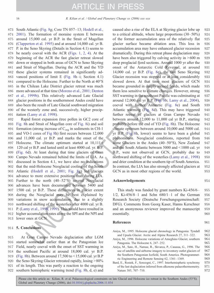
Fig. 1. The inset shows southernmost South America with the present-daPleistocene glacier extent (Caldenius, 1932), and the probable extent during thsection between 52°S and 54°S include the investigated area of the Gran Cammoraine systems A to E (Clapperton et al., 1995; McCulloch et al., 2000) amoraine systems D and E are shown for the area of Gran Campo Nevado, S
Please cite this article as: Kilian, R. et al. Palaeoecological constraints onGlobal and Planetary Change (2006), doi:10.1016/j.gloplacha.2006.11.034
OOF
et al., 2000; Hajdas et al., 2003 which would suggestinterhemispheric linkage (Bard et al., 1997; Blunier et al.,1998; Steig et al., 1998)).
Based on proxies from a marine sediment core, Lamyet al. (2004) suggested that changes in the Pleistoceneextent of the Patagonian Ice Field had a 1000 yr delayedresponse to changes in Pacific surface water tempera-tures which are linked with the Antarctic sea ice index.However, glacier extent in the Andes may not only becontrolled by temperature, but also by precipitationwhich may be related to the intensity and shifting of thewesterlies (e.g. Heusser, 1989; Labeyrie et al. 2003).Constraints for palaeo-precipitation by lake levelreconstructions (e.g. Gilli et al., 2001) or pollen records(McCulloch and Davies, 2001; Moreno et al., 2001;Markgraf et al., 2003 are still scarce for this region andmay depict conditions only for local or restrictedregional areas. It has to be taken into account that
TEDPRy extent of the Southern Patagonian Ice Field (SPI), the maximume Late Glacial Maximum (LGM, Lliboutry, 1998). The detailed Andeanpo Nevado and the Seno Skyring fjord system. Glacial and Late Glacialre shown for Seno Otway and the Strait of Magellan. Possibly relatedeno Skyring and Seno Otway, and are discussed in the text.
late Glacial and Holocene ice retreat in the Southern Andes (53°S).

UNCORRECTED PROF
Fig. 2. Topographical and bathymetrical map of Gran Campo Nevado and Seno Skyring area with UTM grid (South American 69). The bathym ry of the fjords and sub-aquatic moraine systems weremapped with echo sounding (Section 2.2) and include data from hydrographical map Nr. 11700 (Senos Otway y Skyring; scale 1:260000) from ervicio Hidrografico y oceanografico de la Armada deChile. The topography was adapted from Chilean Topographical Maps 1:100,000 and for the Gran Campo area from Schneider et al. (this i e-a,b). Based on topographical information and fieldmapping, the palaeo-drainage system of the Skyring Glacier lobe was mapped. The Moraine B system represents the LGM glacier extent (C perton et al., 1995) and corresponds to the Rio Verdemoraine system (Mercer, 1970, 1976). Further sub-aquatic moraine systems D and E have been mapped by echo sounding (Section 2.2). The cation of bathymetrical profile 1 (Fig. 3) is indicated.The Insets 4.1 to 4.4 are presented in Fig. 4.
3R.Kilian
etal.
/Global
andPlanetary
Change
xx(2006)
xxx–xxx
ARTICLE
INPRESS
Please
citethis
articleas:
Kilian,R
.etal.
Palaeoecological
constraintson
lateGlacial
andHolocene
iceretreat
inthe
Southern
Andes
(53°S).
Global
andPlanetary
Change
(2006),doi:10.1016/j.gloplacha.2006.11.034
OetSssulaplo
135
136
137
138
139
140
141
142
143
144
145
146
147
148
149
150
151
152
153
154
155
156
157
158
159
160
161
162
163
164
165
166
167
168
169
170
171
172
173
174
175
176
177
4 R. Kilian et al. / Global and Planetary Change xx (2006) xxx–xxx
ARTICLE IN PRESS
different localities across the strong climate divide of theSouthern Andes (with snow accumulation of up to13.5 m/yr of water equivalent along the main divide;Godoi et al., 2002) may be affected differently: Strongerwesterlies result in higher precipitation near the climatedivide of the Andes, but in lower precipitation in theeasterly foehn-dominated pre-andean range, and viceversa (e.g. Schneider et al., 2003).
Glacier fluctuations in the Southern Andes do notalways clearly reflect changing climate conditions.Especially the velocity of ice retreat may be controlledby glacier bed morphology. In particular depth of lakesor fjords is an important factor controlling glaciers to begrounded or floating (e. g. Pio XI glacier: Rivera et al.,1997; Rivera and Casassa, 1999; O'Higgins glacier:Casassa et al., 1997). Greater depth of proglacial lakesor fjords seems to enhance calving activity in freshwater and even more so in tide water (Warren andAniya, 1999).
This study tries to constrain the timing and phases ofthe 120 km long ice retreat from proglacial lake SenoSkyring at 53°S to the small present-day ice cap of GranCampo Nevado (GCN) in the southernmost Andes. The
UNCO
RREC
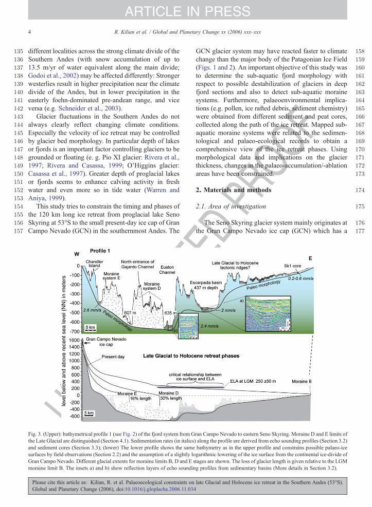
Fig. 3. (Upper): bathymetrical profile 1 (see Fig. 2) of the fjord system from Gthe Late Glacial are distinguished (Section 4.1). Sedimentation rates (in italicsand sediment cores (Section 3.3); (lower) The lower profile shows the samesurfaces by field observations (Section 2.2) and the assumption of a slightly loGran Campo Nevado. Different glacial extents for moraine limits B, D and E smoraine limit B. The insets a) and b) show reflection layers of echo soundin
Please cite this article as: Kilian, R. et al. Palaeoecological constraints onGlobal and Planetary Change (2006), doi:10.1016/j.gloplacha.2006.11.034
PROO
F
GCN glacier system may have reacted faster to climatechange than the major body of the Patagonian Ice Field(Figs. 1 and 2). An important objective of this study wasto determine the sub-aquatic fjord morphology withrespect to possible destabilization of glaciers in deepfjord sections and also to detect sub-aquatic morainesystems. Furthermore, palaeoenvironmental implica-tions (e.g. pollen, ice rafted debris, sediment chemistry)were obtained from different sediment and peat cores,collected along the path of the ice retreat. Mapped sub-aquatic moraine systems were related to the sedimen-tological and palaeo-ecological records to obtain acomprehensive view of the ice retreat phases. Usingmorphological data and implications on the glacierthickness, changes in the palaeo-accumulation/-ablationareas have been constrained.
2. Materials and methods
2.1. Area of investigation
The Seno Skyring glacier system mainly originates atthe Gran Campo Nevado ice cap (GCN) which has a
TED
ran Campo Nevado to eastern Seno Skyring. Moraine D and E limits of) along the profile are derived from echo sounding profiles (Section 3.2)bathymetry as in the upper profile and constrains possible palaeo-icegarithmic lowering of the ice surface from the continental ice-divide oftages are shown. The loss of glacier length is given relative to the LGMg profiles from sedimentary basins (More details in Section 3.2).
late Glacial and Holocene ice retreat in the Southern Andes (53°S).
178
179
180
181
182
183
184
185
186
187
188
189
190
191
192
193
194
195
196
197
198
199
200
201
202
203
204
205
206
207
208
209
210
211
212
213
214
215
216
217
218
219
220
221
222
223
224
225
226
227
228
229
230
231
232
233
234
235
236
237
238
239
240
241
242
243
244
245
246
247
248
249
250
251
252
253
254
255
256
257
258
259
260
261
262
263
264
265
266
267
268
269
270
271
272
273
274
5R. Kilian et al. / Global and Planetary Change xx (2006) xxx–xxx
ARTICLE IN PRESS
UNCO
RREC
maximum elevation of 1750 m and is located at 53°S onthe southern Península Muñoz Gamero (PMG), Chile(Fig. 1). At present the GCN ice cap covers an area of199.5 km2 (Schneider et al., this issue-a,b). It representsa remnant of a continuous ice field, which during theLGM stretched from the Northern and SouthernPatagonian Icefield (NPI and SPI) to the CordilleraDarwin (Fig. 1 inset; Caldenius, 1932; Mercer, 1970;Mercer, 1976). From the Pleistocene ice divide severallarge glacier systems reached 120 to 200 km towards theeast. Ice recession left behind extensive proglacial lakeand fjord systems like Seno Skyring, Seno Otway andthe Strait of Magellan (Figs. 1, 2).
2.2. Echo sounding, bathymetry and sediment cores
The fjord bathymetry and sediment structures wereinvestigated by a Parametric Echo Sounding System SES96 from Innomar (Wunderlich and Wendt, 2001; http://www.innomar.com). The SES 96 has a depth range of 0.5to 800 m with a vertical resolution of b5 cm. Waterdepths were calculated from the high frequency signal,which was calibrated for measured water temperaturesand salinity (http://www.npl.co.uk/acoustics/techguides/soundseawater/content.html). The low frequency signalsof the transmitter were chosen between 4 and 12 kHz,trying to get an optimal penetration and resolution fordifferent sediment types. The pulse length was 0.08–1 ms and the beamwidth ±1.8°. Sediment depths in echosounding profiles were calibrated by using five 4–5 mlong 14C-dated sediment cores. Penetration was usuallybetween 30 to 50 m. At some local areas sedimentpenetration was low, probably due to gas formation inorganic-rich sediment layers.
Based on echo sounding profiles, representativesediment cores were taken with a 5 m long pistoncorer (6.5 cm diameter: www.uwitec.au) in fjords andlakes along the transect from GCN to eastern SenoSkyring (Figs. 2–4) with the RV Gran Campo IIbetween March 2002 to October 2003. Here weconcentrate on three sediment cores, which include thetime span from the Late Glacial to the Holocene (Fig. 5).A 4.7 m long core (Sk1) was taken in the eastern sectionof Seno Skyring in 72 m water depth and N8 km fromthe nearest shoreline (Fig. 2). The flat slopes of thisbasin may have precluded turbidites and coarse clasticsediment input. A 4.6 m long core (VO-1) was obtainedin 37 m water depth at the north-eastern end of Vogelfjord, an ancient glacial valley originating at CerroLadrillero (Fig. 4.4). A 6.4 m long core (CH-1) wastaken from a small (70×150 m) lake on Chandler Islandin the Gajardo Channel (Fig. 4.1).
Please cite this article as: Kilian, R. et al. Palaeoecological constraints onGlobal and Planetary Change (2006), doi:10.1016/j.gloplacha.2006.11.034
TEDPR
OOF
2.3. Age dating
14C measurements were done by HVEE Tandetronaccelerator mass spectrometry (AMS) at Leibniz Labora-tory of the University of Kiel, University of Erlangen andPoland (www.radiocarbon.pl). The activity of 14C wasdetermined from acid extracts of terrestrial macrofossilsfrom the sediment cores. In the investigated peat coreGC2(Figs. 4.1 and 6d) plant macrofossils were obtained bysieving 2 g of wet peat through a 1 mm meshed sieve toremove roots and pieces of wood from the peat. 14C-activity was determined in humic acid extracts and also inthe humic acid extraction-residues. 13C/12C-ratios weremeasured simultaneously by AMS and used to correctmass fractionation. Conventional radiocarbon ages andcalibrated ages are given in Table 1. All calibrated 14Cages in the text and figures represent mean of one sigmarange and has been calibrated with Calpal software (http://wwkw.calpal.de), using the new Calpal July 2004calibration curve. It is suggested that this is the bestavailable calibration curve at present, because it considersthe most important recent calibrations for different timeintervals. Further details are given at http://www.calpal.deand are discussed in Lamy et al. (2004; supporting onlinematerial). Cited 14C ages, which were used for com-parison, especially in Fig. 8, have also been recalculatedwith Calpal 2004 and Calib 4.4.
2.4. Chemical analysis
Major and some trace elements (e.g. Sr, Ba, Zr) havebeen measured by Atomic Absorption Spectrophotom-etry (AAS; Perkin-Elmer). 100 mg of sediment weredried (105 °C) and were fused in Pt skillets with 400 mgof a flux material (mixture of Lithiumtetraborate,Lithiumcarbonate and Lanthanoxide). Produced glasspearls were dissolved in 40 ml HCl (0.5 N). Liquids ofsamples and international standards (MRG-1, SY-2 andJG-2) were measured by the AAS. Determined majorelements, loss on ignition (1050 °C), and independentlydetected contents of CO2 and SO2 resulted in sums of 99to 101 wt.%. Carbon and sulphur concentrations weredetermined by means of a C/S-Analyser (ELEMEN-TAR) burning 10–20mg sample aliquots in a tin capsule.Mean relative standard deviations were 2.2% for C and2.1% for S determinations. Estimated detection limitswere 0.01 wt.% for carbon and 0.02 wt.% for sulphur.
2.5. Granulometry
The particle size analyses were made with a GalaiCIS-1 laser particle counter with an analytical range
late Glacial and Holocene ice retreat in the Southern Andes (53°S).
NCOR
RECT
EDPR
OOF
275
276
277
278
279
280
281
282
283
284
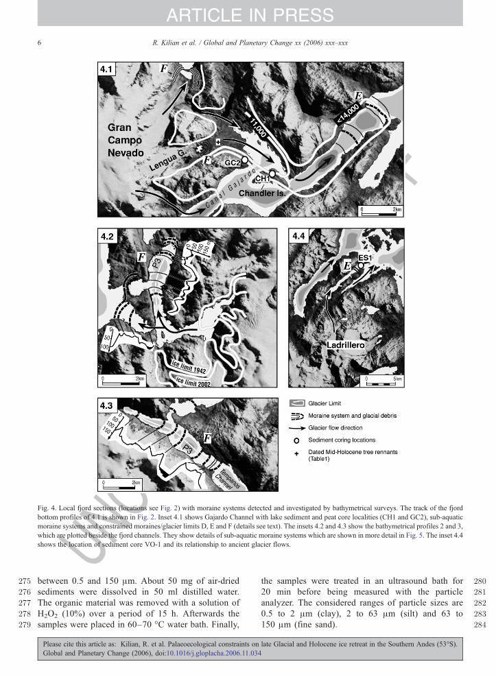
Fig. 4. Local fjord sections (locations see Fig. 2) with moraine systems detected and investigated by bathymetrical surveys. The track of the fjordbottom profiles of 4.1 is shown in Fig. 2. Inset 4.1 shows Gajardo Channel with lake sediment and peat core localities (CH1 and GC2), sub-aquaticmoraine systems and constrained moraines/glacier limits D, E and F (details see text). The insets 4.2 and 4.3 show the bathymetrical profiles 2 and 3,which are plotted beside the fjord channels. They show details of sub-aquatic moraine systems which are shown in more detail in Fig. 5. The inset 4.4shows the location of sediment core VO-1 and its relationship to ancient glacier flows.
6 R. Kilian et al. / Global and Planetary Change xx (2006) xxx–xxx
ARTICLE IN PRESS
U
between 0.5 and 150 μm. About 50 mg of air-driedsediments were dissolved in 50 ml distilled water.The organic material was removed with a solution ofH2O2 (10%) over a period of 15 h. Afterwards thesamples were placed in 60–70 °C water bath. Finally,
Please cite this article as: Kilian, R. et al. Palaeoecological constraints onGlobal and Planetary Change (2006), doi:10.1016/j.gloplacha.2006.11.034
the samples were treated in an ultrasound bath for20 min before being measured with the particleanalyzer. The considered ranges of particle sizes are0.5 to 2 μm (clay), 2 to 63 μm (silt) and 63 to150 μm (fine sand).
late Glacial and Holocene ice retreat in the Southern Andes (53°S).

EDPR
OOF
285
286
287
288
289
290
291
292
293
294
295
296
297
298
299
300
301
302
303
304
305
306
307
308
309
310
311
312
313
314
315
316
317
318
319
320
321
322
323
324
325
326
327
328
329
330
Fig. 5. Comparison of LIA moraine systems of Lengua Glacier (based on dendrochronologically determined ages; location in 4.1; Koch and Kilian, inpress) with the bathymetry of sub-aquatic moraine systems in the Tempanos Channel (Fig. 4.2) and the West Glacier Basin (Fig. 4.3), as determinedby echo sound profiling.
7R. Kilian et al. / Global and Planetary Change xx (2006) xxx–xxx
ARTICLE IN PRESS
UNCO
RREC
2.6. Palynology
The 2.9 m long peat to sediment core GC-2 (52° 48′37″ S, 72° 55′46″ W) was obtained in proximity to thepresent-day GCN ice cap (Fig. 4.1). The site is located ina small basin (120×80 m) between roche moutonees ofthe ancient glacial valley in an altitude of about 70 mabove sea level. Sampling was done with a Russian corerand for the uppermost 1.8 m of the peat also with a10×10×200 cm stainless steel WARDENAAR corer(Wardenaar, 1987). The upper 180 cm consist of peat,which rests on top of 80 cm of glaci-lacustrine sediments(Fig. 6d). Chemical and mineralogical characteristics aredescribed by Franzen et al. (2004). Samples for pollenwere collected from 2 cm cuts of the core. Due to 14Cdating each sample represents less than 200 yr (Fesq-Martin et al., in press). The samples were processedusing standard techniques (e.g. Faegri and Iversen, 1989).Exotic spores (Lycopodium) were added to calculatepollen concentrations. Frequencies (%) of trees, shrubsand herbs typically added up to terrestrial pollen sums of400–900 grains. Further information on pollen identifi-cation, pollen of aquatic plants, spores, and ecologicalimplications for the evolution of the Magellanic Rain-forest are given by Fesq-Martin et al. (in press). Here we
Please cite this article as: Kilian, R. et al. Palaeoecological constraints onGlobal and Planetary Change (2006), doi:10.1016/j.gloplacha.2006.11.034
Tconcentrate on selected pollen with implications forpalaeo-climate and extend of glaciation.
3. Results
3.1. Morphology and bathymetry
Glacier flow direction and thickness of glaciersflowing from the Gran Campo Nevado ice cap towardsSeno Skyring (Fig. 2) were constrained by fieldobservations of striations on basement rocks, fjordmorphology and the elevation at which erratic blockswere found. In the Skyring drainage area (Fig. 2) glaciersof Gran Campo Nevado and Cerro Ladrillero followed10–25 km long, NE-striking fjords, which have beeneroded along dextral transform faults (Fischbach et al.,2001). These 3 to 7 kmwide fjords converge in the EustonChannel where the glaciers turned east. The palaeo-drainage system of Skyring Glacier was mapped in Fig. 2within a South American 69-UTM grid by fieldobservations, a Landsat TM 5 scene, Shuttle RadarTopography Mission data (http://srtm.usgs.gov), topo-graphical maps (Carta Aeronautica, SAF 1:250 000) andaerial photos of the region around Gran Campo Nevado(Schneider et al., this issue-a,b).
late Glacial and Holocene ice retreat in the Southern Andes (53°S).

UNCO
RREC
TEDPR
OOF
331
332
333
334
335
336
337
338
Fig. 6. Depth profiles of sediment and peat cores from the Seno Skyring and Gran Campo Nevado area with tephra layers (minimum and maximumages after Kilian et al., 2003) and 14C ages in cal yr B.P (Table 1 and Section 2.3). Sedimentation rates for certain core sections are given in italicnumbers. a) Sediment core SK-1 (eastern Skyring, Fig. 2) includes chemical pattern (Corg, MgO, SiO2/Al2O3 ratios), volume% of clay fraction(N63 um), and ice rafted debris layer (IRD; with lithic grains N2 mm); b) Sediment core VO-1 (south-western Skyring area, Figs. 2 and 4.4) is shownwith Corg and CaO contents, volume % of clay fraction and IRD layer; c) CH-1 core from a lake on Chandler Island (Locality in Fig. 4.1) include Corg
and Zr contents, and a layer of glacial clay; d) Peat core GC-2 from the Bahia Bahamondes area, northeast of Gran Campo Nevado (Locality inFig. 4.1) with lithological characteristics (minerogenic and glaci-limnic) and % diagram of the terrestrial Nothofagus, Gunnera and Graminae pollen(Fesq-Martin et al., in press).
8 R. Kilian et al. / Global and Planetary Change xx (2006) xxx–xxx
ARTICLE IN PRESS
Echo sounding profiles of a total length of 560 kmwere obtained from the Skyring fjord system. Thebathymetry of Fig. 2 was obtained from longitudinalecho sounding profiles of the fjords (Figs. 3, 4),
Please cite this article as: Kilian, R. et al. Palaeoecological constraints onGlobal and Planetary Change (2006), doi:10.1016/j.gloplacha.2006.11.034
completed by perpendicular and zigzag echo soundingprofiles and are compiled together with water depthinformation from hydrographical map Nr. 11700 (SenosOtway y Skyring; scale 1:260 000) from Servicio
late Glacial and Holocene ice retreat in the Southern Andes (53°S).

RECT
EDPR
OOF
339
340
341
342
343
344
345
346
347
348
349
350
351
352
353
354
355
356
357
358
359
360
361
362
363
364
365
366
367
368
Table 1t1:1
AMS 14C ages with calibrations after CALIB 4.4 and CALPAL, used for age constraints in peat and sediment cores and a mortified Mid-Holocene treeremnantt1:2
t1:3 Core Core depth cm Submittedmaterial
14C age cal BP age ranges(1 sigma) a
Calibrated yr BP b
(1 sigma)Laboratory Reference
t1:4 CH-1 337 Macro restN5 mg C
3545±35 3727–3747, 3762–3791,3825–3873, 3877–3887
3813±63 Poland c this paper
t1:5 CH-1 422 Macro rest1.6 mg C
4420±40 4873–4934, 4958–5047,5194–5205
5055±138 Kiel d Kilian et al.(2003)
t1:6 CH-1 520 Macro rest4.8 mg C
7890±45 8599–8724, 8727–8769,8833–8844, 8922–8927
8751±112 Kiel d Kilian et al.(2003)
t1:7 CH-1 536 Macro rest0.6 mg C
8520±70 9471–9548 9510±35 Kiel d Kilian et al.(2003)
t1:8 CH-1 605 Macro rest2.9 mg C
10320±55 11781–11788, 11946–12340,12549–12556
12111±190 Kiel d Kilian et al.(2003)
t1:9 GC-2 31 Macro restN3 mg C
2620±30 2742 - 2765 2755±10 Kiel d Fesq-Martin et al.(in press)
t1:10 GC-2 41 Macro restN3 mg C
3382±44 3569–3650, 3654–3688 3623±55 Erlangen e Fesq-Martin et al.(in press)
t1:11 GC-2 133 Macro restN3 mg C
7288±67 8026–8099, 8105–8167 8092±65 Erlangen e Fesq-Martin et al.(in press)
t1:12 GC-2 165 Macro restN2 mg C
9024±80 9921–9933, 9958–9993,10011–10017, 10031–10055,10069–10078, 10112–10135,10146–10242, 10353–10354
10111±120 Erlangen e Fesq-Martin et al.(in press)
t1:13 GC-2 191 Macro restN2 mg C
9659±83 10786–10829, 10842–10943,11012–11015, 11062–11175
10978±160 Erlangen e Fesq-Martin et al.(in press)
t1:14 GC-2 195 Macro rest4.3 mg C
9740±42 11140–11149, 11155–11200 11168±24 Kiel d Fesq-Martin et al.(in press)
t1:15 GC-2 269 Macro rest0.3 mg C
12017±203 13544–13734, 13787–14330,14861–14936
13865±327 Kiel d Fesq-Martin et al.(in press)
t1:16 VO-1 365 Macro restN3 mg C
9490±50 10600–10608, 10640–10656,10671–10766, 10833–10836,10958–11005, 11017–11059
10848±170 Poland c this paper
t1:17 GCN-02-GB Tree remnant4.3 mg C
4719±49 5327–5383, 5394–5396,5449–5485, 5529–5578
5455±99 Kiel d this paper
a Ages calibrated with CALIB REV 4.4.2 and database intcal 98 (Stuiver and Reimer, 1993, Radiocarbon, 35, 215–230).t1:18b Ages calibrated with CALPAL and the calibration curve CalPal2004_SFCP.t1:19c Poznan Radiocarbon Laboratory, Poland.t1:20d Leibniz Labor für Altersbestimmung und Isotopenforschung Christian-Albrechts-Universität Kiel.t1:21e Physikalisches Institut der Universität Erlangen-Nürnberg.t1:22
9R. Kilian et al. / Global and Planetary Change xx (2006) xxx–xxx
ARTICLE IN PRESS
UNCO
RHidrografico y oceanografico de la Armada de Chile(SHOA). In addition, profiles were obtained from therelatively shallow (b220 m) eastern section of SenoOtway (Fig. 1), where no sub-aquatic moraine systemshave been detected.
Along the Skyring fjord system the greatest depthsoccur in Euston Channel (635 m water depth; Figs. 2and 3) and in the northern entrance of Gajardo Channel(607 m water depth). This is a significantly smallerglacial overdeepening than in the western Strait ofMagellan (∼1130 m water depth; Hydrographical MapNr. 11000 with scale 1:1,000,000 from SHOA) andBaker Fjord (1344 m water depth) between SPI and NPI.Longitudinal Profile 1 (Figs. 2 and 3) illustrates thebathymetry and sediment structures along the glacier
Please cite this article as: Kilian, R. et al. Palaeoecological constraints onGlobal and Planetary Change (2006), doi:10.1016/j.gloplacha.2006.11.034
pathway from the Late Glacial ice divide at Gran CampoNevado towards Seno Skyring. The greatest waterdepths occur in the central and western drainage system(Fig. 3). Mapping of fjord morphology and erraticblocks along the Euston Channel (Fig. 2) indicate thatthe maximum valley glacier surface did not exceedaround 400 m present-day elevation. Together with thefjord bathymetry this indicates that the ice sheet mayhave reached around 900 to 1000 m thickness in thewestern Skyring section and implies that the glacier wasgrounded (Fig. 3, lower profile). This ice thickness ismuch smaller than proposed for the SPI during the LGM(up to 2700 m ice thickness: e.g. Hulton et al., 1994).Large water depths occur also in sections wheremorphology and bathymetry indicate that glacier flow
late Glacial and Holocene ice retreat in the Southern Andes (53°S).
369
370
371
372
373
374
375
376
377
378
379
380
381
382
383
384
385
386
387
388
389
390
391
392
393
394
395
396
397
398
399
400
401
402
403
404
405
406
407
408
409
410
411
412
413
414
415
416
417
418
419
420
421
422
423
424
425
426
427
428
429
430
431
432
433
434
435
436
437
438
439
440
441
442
443
444
445
446
447
448
449
450
451
452
453
454
455
456
457
458
459
460
461
462
463
464
465
466
467
468
10 R. Kilian et al. / Global and Planetary Change xx (2006) xxx–xxx
ARTICLE IN PRESS
UNCO
RREC
was constricted (e.g. in a 437 m deep basin to the southof Escarpada Island (Fig. 2), probably due to thenarrowing of the glacial valley which leads to higherflow velocity and successively higher erosion rates atthe basis of the glacier.
Profile 1 of Fig. 3 shows several sub-aquatic ridges,which occur perpendicular to the palaeo-glacier flowdirection (Fig. 2), mainly in Gajardo Channel (Fig. 4.1).In fjords around Gran Campo Nevado these sub-aquaticridges are interpreted as moraine systems, if norelationship to on-land geomorphology or tectonic ridgesare recognized (Figs. 4.1 and 5). With the exception ofthe Tempanos fjord section of Gajardo Channel (Fig. 4.2)there are no moraine remnants above sea or lake level onthe steep fjord slopes. To the east of Euston Channel andin Seno Skyring no moraine ridges were found. Severalsub-aquatic ridges were found across the middle sectionof Seno Skyring from north to south with less than 100mwater depth (Figs. 2, 3). These ridges can be traced toNeogene faults and thrusts that are found on land nearby(Fischbach et al., 2001; Lodolo et al., 2002; Fig. 2).Some of these ridges are so prominent that we suggestthat they were still active during the Late Glacial and/orthe Holocene or that they could represent verticaldisplacements related to glacial rebound of the Andes.
3.2. Sediment echo sounding
Sediment echo sounding profiles in eastern SenoSkyring show 5 to 10 m of fine-grained well-sortedsediments with sharp reflectors on top of coarse clasticand unsorted glacial detritus which were identified insediment core SK-1 (Section 3.3) as ice rafted debris(IRD). Below the IRD reflector only little sediment(b1 m) was deposited above another reflector, which didnot enable further penetration for the echo sound. Weinterpret basal reflector as the older consolidated,probably Tertiary, sedimentary basement. Assumingthat the upper 5 to 10 m thick sediment layer wasdeposited during the last 17,500 yr (compare results ofSK-1 sediment core in Fig. 6a and Section 3.3), the LateGlacial and Holocene sedimentation rates have variedbetween 0.3 to 0.6 mm/yr in this proglacial lake section.
In the 437mdeep basin to the south of Escarpada Islandin central Seno Skyring (Fig. 2) the sediment echogramshows around 30 m of fine-grained and well-sorted LateGlacial and Holocene sediments on top of the basement(Figs. 3, inset a). Assuming deposition during the last16,000 yr after ice retreat (Section 4, Discussion), thissuggests even higher sedimentation rates of ∼2 mm/yr.
Further to the west, where annual precipitation isgreater than 2500 mm/yr (Schneider et al., 2003),
Please cite this article as: Kilian, R. et al. Palaeoecological constraints onGlobal and Planetary Change (2006), doi:10.1016/j.gloplacha.2006.11.034
TEDPR
OOF
echograms from the 635 m deep basin in the Eustonchannel (Fig. 3, inset b) show 36 m of fine-grained andwell-sorted Late Glacial and Holocene sediments. Theice retreat from Euston Channel (Fig. 2) was constrainedbetween around 16,500 and 14,000 cal. yr B.P.(Discussion on timing ice retreat in Section 4.1).Assuming a deposition during the last 15,000 yr afterthe ice retreat, the sedimentation rates amount to 2.4 mm/yr. In basins between moraine E ridges in the GajardoChannel (Figs. 2, 3 and 4.1) echograms show up to 37 mof fine-grained clayey sediments. Assuming an iceretreat from this area after around 14,000 cal. yr B.P.(Sections 3.3 and 4.1), calculated sedimentation rateswere in excess to 2.6 mm/yr. This can be explained byhigh annual precipitation in excess to 6500 mm/yr(Schneider et al., 2003) and the input of glacial clay fromthe Holocene outlet glaciers of GCN (Schneider et al.,this issue-a,b).
3.3. Sediment records
The clayey to silty SK-1 sediment core (Figs. 2, 6a)from eastern Seno Skyring does not contain macro plantremnants or biogenic carbonate for 14C determination.Organic carbon content is lower than 1.5 wt.% and wasconsidered as not suitable for 14C dating. However, tephralayers fromvolcanoes of theAustral AndesVolcanic Zone(AVZ) can be identified by their geochemical fingerprint(Stern, 1990). ICP-MS trace element data (analysed atAct-Labs: www.actlabs.com) were obtained for glassfractions of each tephra layer. The Sr/Y, La/Yb and Zr/Hfratios were used to distinguish products of the AVZvolcanoes Aguilera, Burney and Reclus (Stern andKilian,1996). Age constraints for these tephra layers have beengiven specifically for the Strait of Magellan and Skyringarea by Kilian et al. (2003). In the SK-1 core an Aguileratephra was identified in 82–84 cm depth (b3596±230 cal. yr B.P; Fig. 6a; Kilian et al., 2003), a prominenttephra ofMt. Burneywas detected in 102 to 108 cm depth(4254±120 cal. yr B.P.; McCulloch and Davies, 2001;Kilian et al., 2003), another early Holocene Mt. Burneylayer was at 192–195 cm depth (minimum of 9009±17and maximum of 9175±111 cal. yr B.P.; Kilian et al.,2003) and a layer of Reclus volcano was found in 356–358 cm depth (minimum of 15,380±578 and maximumof 15,930±476 cal. yr B.P.; Kilian et al., 2003). These ageconstraints indicate relatively low sedimentation ratesbetween 0.16 and 0.26 mm/yr, with the lowest rates of0.16 mm/a during the Holocene climate optimumbetween 9000 and around 4500 yr ago (Fig. 6a, 7f andSection 4). An IRD layer with lithic grains N2 mm wasfound at 420 cm core depth. Assuming sedimentation
late Glacial and Holocene ice retreat in the Southern Andes (53°S).
PROO
F
469
470
471
472
473
474
475
476
477
478
479
480
481
482
483
484
485
486
487
488
489
490
491
492
493
494
495
496
497
498
499
500
501
502
503
504
505
506
507
508
509
510
511
512
513
514
515
516
517
518
519
520
521
522
523
524
525
526
527
528
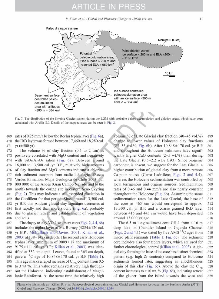
Fig. 7. The distribution of the Skyring Glacier system during the LGM with probable palaeo-accumulation and ablation areas, which have beencalculated with ArcGis 8.0. Details of the mapped areas can be seen in Fig. 2.
11R. Kilian et al. / Global and Planetary Change xx (2006) xxx–xxx
ARTICLE IN PRESS
UNCO
RREC
rates of 0.25mm/a below theReclus tephra layer (Fig. 6a),the IRD layer was formed between 17,460 and 18,280 cal.yr (±500 yr).
The volume % of clay fraction (0.5 to 2 μm) ispositively correlated with MgO content and negativelywith SiO2/Al2O3 ratios (Fig. 6a). Between around16,000 to 13,500 cal. yr B.P., relatively high amountsof clay fraction and MgO contents indicate a chlorite-rich sediment transport from mafic lithologies (RocasVerdes formation: Mapa Geologica de Chile 2003; 1:1000 000) of the Andes (Gran Campo Nevado and to thenorth) towards the coring site in eastern Seno Skyring(Fig. 2). This may indicate a still extended glaciation inthe Cordillera for that period. Since around 13,500 cal.yr B.P. this Andean glacial-clay signature decreases atfirst rapidly and than more slowly (Fig. 6a), probablydue to glacier retreat and establishment of vegetationand soils.
The clayey to siltyVO-1 sediment core (Figs. 2, 4.4, 6b)includes the tephra layer of Mt. Burney (4254±120 cal.yr B.P.; McCulloch and Davies, 2001; Kilian et al.,2003) at 138–142 cm depth. The second early Holocenetephra layer (minimum of 9009±17 and maximum of9175±111 cal. yr B.P.; Kilian et al., 2003) was iden-tified at 332 cm depth. Leaves, found at 365 cm depth,gave a 14C age of 10,848±170 cal. yr B.P (Table 1).This age marks a rapid increase of Corg content from 0.5to 3 wt.%. This value remains relatively high through-out the Holocene, indicating establishment of Magel-lanic Rainforest. At the same time the relatively high
Please cite this article as: Kilian, R. et al. Palaeoecological constraints onGlobal and Planetary Change (2006), doi:10.1016/j.gloplacha.2006.11.034
TEDvolume % of Late Glacial clay fraction (40–45 vol.%)
change to lower values of Holocene clay fractions(25–35 vol.%; Fig. 6b). After 10,848±170 cal. yr B.Pand throughout the Holocene sediments have signif-icantly higher CaO contents (2–5 wt.%) than duringthe Late Glacial (0.5–2.2 wt% CaO). Since biogeniccarbonate is absent, we suggest for the Late Glacial ahigher contribution of glacial clay from a more remoteCa-poor source (Cerro Ladrillero; Figs. 2 and 4.4),whereas the Holocene sedimentation was controlled bylocal terrigenous and organic sources. Sedimentationrates of 0.46 and 0.44 mm/a are also nearly constantthroughout the Holocene (Fig. 6b). Assuming the samesedimentation rates for the Late Glacial, the base ofthe core at 465 cm would correspond to approx.13,300 cal. yr B.P. and a coarse grained IRD layerbetween 415 and 443 cm would have been depositedaround 13,000 yr ago.
The 6.5 m long sediment core CH-1 from a 16 mdeep lake on Chandler Island in Gajardo Channel(Figs. 2 and 4.1) was dated by five AMS 14C ages frommacro plant remnants (Table 1; Fig. 6c). The sedimentcore includes also four tephra layers, which are used forfurther chronological control (Kilian et al., 2003). A gla-cial clay forming the base of the core has distinct chemicalpattern (e.g. high Zr contents) compared to Holocenesediments formed later, suggesting an allochthonousorigin of this clay (Fig. 6c). Above the clay the Corg
content increases to N10wt. % (Fig. 6c), indicating retreatof the glacier from the island towards the west and
late Glacial and Holocene ice retreat in the Southern Andes (53°S).
529
530
531
532
533
534
535
536
537
538
539
540
541
542
543
544
545
546
547
548
549
550
551
552
553
554
555
556
557
558
559
560
561
562
563
564
565
566
567
568
569
570
571
572
573
574
575
576
577
578
579
580
581
582
583
584
585
586
587
588
589
590
591
592
593
594
595
596
597
598
599
600
601
602
603
604
605
606
607
608
609
610
611
612
613
614
615
616
617
618
619
620
621
622
623
624
625
626
627
628
12 R. Kilian et al. / Global and Planetary Change xx (2006) xxx–xxx
ARTICLE IN PRESS
UNCO
RREC
northwest, and the start of soil development andvegetation colonisation on Chandler Island (Fig. 4.1). A14C date of 12,110±190 cal. yr B.P. marks this rapidchange to biogenic sedimentation and glacier retreat fromthe Chandler Island. The Holocene record of CH-1 showshighCorg contents and higher sediment accumulation afterthe Mt. Burney eruption (4254 cal. yr B.P.), which weinterpret as a result of tephra rework rather than a climaticsignal (Kilian et al., 2003).
3.4. Pollen record
The 269 cm long core GC 2 (Locality in Figs. 4.1and 6b) has been dated by seven AMS 14C-ages (Table 1;Franzen et al., 2004; Fesq-Martin et al., in press) andtephrachronology (Kilian et al., 2003). Details of thepollen spectrum are given by Fesq-Martin et al. (in press).Sedimentation and pollen deposition at this site could nothave started before significant recession of the glacier inGajardo Channel (Fig. 4.1.). Between 13,860±327 and11,170±24 cal. yr B.P. the pollen record is characterizedby the species-poor association of the pioneer plantGunnera magellanica together with Cyperacea andNothofagus which sum up to N90% of all terrestrialpollen. This is the typical present-day plant association forwell-drained moraines and glacial debris near glacierlimits. The likely lateral glacier extent below the GC2 isshown in Fig. 4.1 for this time interval. Consideringinclination of N5° for the glacier surface in flow direction,the glacier could not have reached further into GajardoChannel than moraine E limit. From 10,110±120 cal. yrB.P. until at least the mid-Holocene, the palynologicalrecord shows a plant association that is typical for anevolved Magellanic Rainforest (climax stage). Thisindicates temperate and humid conditions comparable topresent-day conditions throughout the early to mid-Holocene. Only after the eruption of Mt. Burney(4250 cal. yr B.P.; Kilian et al., 2003) the palynologicalrecord (Fig. 6d) shows disturbances, which are morelikely related to tephra deposition with associatedsediment rework than climate fluctuations.
3.5. Constraints on palaeo-accumulation and ablationareas
The accumulation area ratio (AAR) of mid-latitudeglaciers is usually around 0.6. Most Patagonian glaciershave higher ratios of 0.7 to 0.8, since the ablation area isreduced due to iceberg calving in tidewater (Aniya et al.,1996). Glaciers, which are in negative disequilibriumwith the present-day climate, may also have low AAR'sof 0.4 (Schneider et al., this issue-a,b). The morphology
Please cite this article as: Kilian, R. et al. Palaeoecological constraints onGlobal and Planetary Change (2006), doi:10.1016/j.gloplacha.2006.11.034
TEDPR
OOF
and bathymetry of the Skyring fjord system (Fig. 2) andthe estimated palaeo-glacier thickness (Fig. 3) suggestthat the Skyring glacier was mostly grounded. However,during glacier recession, iceberg calving could haveincreased the AAR.
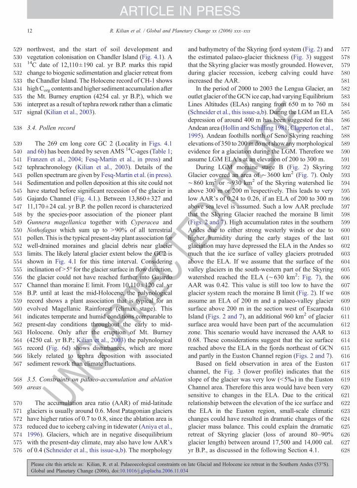
In the period of 2000 to 2003 the Lengua Glacier, anoutlet glacier of the GCN ice cap, had varying EquilibriumLines Altitudes (ELAs) ranging from 650 m to 760 m(Schneider et al., this issue-a,b). During the LGM an ELAdepression of around 400 m has been suggested for thisAndean area (Hollin and Schilling 1981; Clapperton et al.,1995). Andean foothills north of Seno Skyring reachingelevations of 350 to 200mdonot showanymorphologicalevidence for a glaciation during the LGM. Therefore weassume LGM ELA's at an elevation of 200 to 300 m.
During LGM moraine stage B (Fig. 2) SkyringGlacier covered an area of ∼3600 km2 (Fig. 7). Only∼860 km2 or ∼930 km2 of the Skyring watershed lieabove 300 m or 200 m respectively. This leads to verylow AAR's of 0.24 to 0.26, if an ELA of 200 to 300 mabove sea level is assumed. Such a low AAR precludethat the Skyring Glacier reached the moraine B limit(Figs. 2 and 7). High accumulation rates in the southernAndes due to either strong westerly winds or due tohigher humidity during the early stages of the lastglaciation may have depressed the ELA in the Andes somuch that the ice surface of valley glaciers protrudedabove the ELA. If we assume that the surface of thevalley glaciers in the south-western part of the Skyringwatershed reached the ELA (∼630 km2: Fig. 7), theAAR was 0.42. This value is still too low to have theglacier system reach the moraine B limit (Fig. 2). If weassume an ELA of 200 m and a palaeo-valley glaciersurface above 200 m in the section west of EscarpadaIsland (Figs. 2 and 7), an additional 960 km2 of glaciersurface area would have been part of the accumulationzone. This scenario would have increased the AAR to0.68. These considerations suggest that the ice surfacereached above the ELA in the fjords northeast of GCNand partly in the Euston Channel region (Figs. 2 and 7).
Based on field observation in area of the Eustonchannel, the Fig. 3 (lower profile) indicates that theslope of the glacier was very low (b5‰) in the EustonChannel area. Therefore this area would have been verysensitive to changes in the ELA. Due to the criticalrelationship between the elevation of the ice surface andthe ELA in the Euston region, small-scale climaticchanges could have resulted in dramatic changes of theglacier mass balance. This could explain the dramaticretreat of Skyring glacier (loss of around 80–90%glacier length) between around 17,500 and 14,000 cal.yr B.P., as discussed in the following Section 4.1.
late Glacial and Holocene ice retreat in the Southern Andes (53°S).
629
630
631
632
633
634
635
636
637
638
639
640
641
642
643
644
645
646
647
648
649
650
651
652
653
654
655
656
657
658
659
660
661
662
663
664
665
666
667
668
669
670
671
672
673
674
675
676
677
678
679
680
681
682
683
684
685
686
687
688
689
690
691
692
693
694
695
696
697
698
699
700
701
702
703
704
705
706
707
708
709
710
711
712
713
714
715
716
717
718
719
720
721
722
723
724
725
726
13R. Kilian et al. / Global and Planetary Change xx (2006) xxx–xxx
ARTICLE IN PRESS
UNCO
RREC
4. Discussion
4.1. Glacier retreat phases
Regional glacier retreat phases withmoraine systemsAtoE (Figs. 1 and 2) have been proposed for the LateGlacialin the Strait ofMagellan region by Clapperton et al. (1995)and are discussed in the context of our new results:
4.1.1. Moraine limit ADue to missing organic material and 14C dates it is still
disputed how far east Skyring Glacier reached during thelast glaciation. It is possible that this glacier reached as faras Laguna Blanca, corresponding to the moraine limit 3 ofCaldenius (1932; Fig. 1 inset), which is identical with themoraine A limit of Clapperton et al. (1995). For this mostextended moraine A limit no confining ages exist.
4.1.2. Moraine limits B and CThe moraine limit B (Figs. 1 and 2) corresponds to
the moraine limit 4 of Caldenius (1932) and to the RioVerde moraines which were described along the easternshore of Seno Skyring by Mercer (1970). The retreatfrom moraine limit A to B may be due to worldwidedryer conditions at the LGM (e.g. Blunier et al., 1998) orless westerly influence in this area (Lamy et al., 1998,1999). Reported 14C minimum ages for the morainelimit B along the Strait of Magellan date are 16,800 calyr B.P. (Clapperton et al., 1995) and 17,150 cal. yr B.P.(McCulloch et al., 2000). At approximately the sametime(around 17,400 cal. yr B.P.) the end of full glacialclimate conditions was determined for the Chilean Lakedistrict (Lowell et al., 1995; Denton et al., 1999b).
The LGM moraine limit B of Seno Otway and Straitof Magellan were probably formed at the same time thanmoraines around the eastern shore of Seno Skyring(Fig. 1; Mercer, 1976; Clapperton et al., 1995). Theminimum ages of around 17,000 cal. yr B.P. for theinitiation of the recession of Skyring Glacier from themoraine limit B by the former authors (Figs. 2 and 3) isin good agreement with the deposition of ice rafteddebris, for which we have estimated an age of 17,460 to18,280 cal. yr B.P. (Skyring sediment core SK-1 inFig. 6a and details in Section 3.3). The morainesystem C, which was described for the Strait ofMagellan by Clapperton et al. (1995), is not preservedor yet detected along the eastern shore of Seno Skyringand Seno Otway.
4.1.3. Moraine system DClapperton et al. (1995) has mapped a further moraine
system D in the Strait of Magellan. Its age was
Please cite this article as: Kilian, R. et al. Palaeoecological constraints onGlobal and Planetary Change (2006), doi:10.1016/j.gloplacha.2006.11.034
TEDPR
OOF
constrained by a clustering of several 14C minimumages at around∼16,000–17,600 cal. yr B.P. (Clappertonet al., 1995). Moraine limit D appears at 84% glacierlength compared to moraine limit B of the LGM (Fig. 1).No comparable moraine systems have been detectedbetween the eastern shore line of Seno Skyring and thesouth-western region of Euston Channel, where exten-sive sub-aquatic moraines were detected (Figs. 2 and 3).Although the moraines of Euston Channel are undatedand do only represent 30% glacier length compared toLGM, we suggest that they formed coeval to the morainelimit D of the Strait of Magellan, since the IRD layers inthe Eastern Skyring are only small and were formedbetween 17,460 to 18,280 cal. yr. B.P., only somedecades before the formation of moraine system D in theStrait of Magellan (details in Section 3.3). Parts of thisfast retreat from moraine limit B to D occurred in a lakesection with water depths of N600 m (Fig. 3) which mostlikely enhanced glacier recession by iceberg calving andfreshwater circulating below the partially floating snoutof the glacier (Warren and Aniya, 1999). Echo soundingprofiles also do not show sub-aquatic moraines betweenthe north-eastern shoreline of Seno Otway and the smallislands in the south-western section of Seno Otway(Fig. 1). This indicates that in Seno Otway the morainestage D was also formed closer to the Andes (Fig. 1).
During glacier retreat from moraine system B tomoraine system D, the proglacial lakes of Seno Skyringand Seno Otway were connected by Fitz Roy Channel(Figs. 1 and 2, Mercer, 1970) and water of both lakesdrained towards the Atlantic (Fig. 1). This kept the lakelevel relatively constant at around 22–25 m abovepresent-day sea level and lead to the formation oferosional terraces by wave erosion along the lakeshoresexposed to the westerlies. A basal peat in the formerspillway of Seno Otway to the Atlantic was dated byMercer (1970) to 14,599±446 cal. yr B.P. (12,460±190 14C yr). This postdates the deglaciation of JerónimoChannel (Western entrance of Seno Otway), which ledto opening of a fjord-connection to the Pacific (Fig. 1).This age also marks a further glacier recession towardsmoraine limit E (Figs. 1 and 2).
4.1.4. Moraine limit EAround 20 km southwest of the moraine system D in
Euston Channel, a further sub-aquatic moraine systemwas formed in the Gajardo Channel (Figs. 2 and 4.1).Pioneer plants, which typically grow on well-drainedglacial debris, are recorded in the peat Core GC2 between13,864±327 and 11,168±24 cal. yr B.P. They areindicating the presence of a glacier in the fjord valleybelow this site (Section 3.4). Assuming that at this site
late Glacial and Holocene ice retreat in the Southern Andes (53°S).

TEDPR
OO
727
728
729
730
731
732
733
734
735
736
737
738
739
740
741
742
743
744
745
746
747
748
749
750
751
752
753
754
755
756
757
758
759
760
761
762
763
764
765
766
767
768
769
770
771
772
14 R. Kilian et al. / Global and Planetary Change xx (2006) xxx–xxx
ARTICLE IN PRESS
REC
located 70m a.s.l. the glacier surface had an inclination of5–10‰ towards the north-eastern Gajardo Channel(Figs. 3b and 4.1), it is obvious that the glacier couldnot have reached further than to the observed sub-aquaticmoraine system E in the central section of the north-western Gajardo Channel (Fig. 4.1). The ice retreat fromChandler Island (Fig. 4.1) is also traced by the change insedimentation from glacial clay to organic peat-richsediment at 12,111±190 cal. yr B.P. (Fig. 6c). This periodbetween 14,000 and 11,000 cal. yr B.P. correspondswith acertain delay to that of the moraine limit E in the Strait ofMagellan, which represents an extensive, 80 km long LateGlacial glacier advance dated by 14C ages between 15,350to 12,250 cal. yr B.P. (Clapperton et al., 1995; McCullochet al., 2000). While moraine limit E in the Strait ofMagellan represent 45% glacier length compared to theLGM moraine B limit, the related moraine limit E inGajardo Channel represents only 16% glacier lengthcompared to the moraine limit B.
4.1.5. Moraine limit FThe palynological record of GC-2 peat core (Fig. 6d;
Section 3.4) indicates a climate optimum after 10,110±120 cal. yr B.P. until at least the eruption and deposition oftephra from the Mt. Burney volcano at 4250 cal. yr B.P.(Kilian et al., 2003). No sub-aquatic or terrestrial morainesystems have been detected between Chandler Island andthemoraine belt of LenguaGlacier, which situated 8 km tothe west-northwest. These moraines were formed duringthe Little Ice Age (Koch and Kilian, in press) and aretermed moraine limit F (Fig. 4.1). 2 km east of morainelimit F soils and fluvial sediments are deposited on top ofmortified tree trunks, which have been dated to 5460±99 cal. yr B.P. (Locality marked by a cross in Fig. 4.1.;Table 1). This indicates that there was no glacier advance
UNCO
RFig. 8. a–i Comparison of palaeoclimatic data for the last 25,000 yrfrom the Northern Hemisphere (a: δ18O from GRIP2, 77°N: Grooteset al., 1993), the Chilean shelf at 41°S (b: Fe content and AlkenoneSST's in sediments from ODP Site 1233: Lamy et al., 2004), SouthernAndes at 46°S (c: beech forest pollen: Lumley and Switsur, 1993;Bennett et al., 2000), South Atlantic at 50°S (d: δ18O of Globigerinabuloides from sediment core RC11–83, primarily reflecting seasurface temperatures: Ninnemann et al., 1999), Antarctica at 85°S(e: δ18O record from Byrd ice core: Blunier and Brook, 2001), SouthAtlantic at 53°S (f: diatom-based sea ice reconstruction from core TN057–13; Stuut et al, in press and g: Lithic grains in sediment core TN057–13: Hodell et al., 2001) with results from the Gran CampoNevado area in the Southern Andes at 53°S (h: Andean clay signaturewith details in Fig. 6a; Corg contents in sediment cores VO-1 and CH-1with details in Figs. 6b and c; tree pollen of peat core GC2 with detailsin Fig. 6d and in Section 2) and the Strait of Magellan region at 54°S(i: Tree pollen from a peat core: McCulloch et al. 2000). Gray barsindicate the Younger Dryas (YD: Goslar et al., 2000) and HeinrichEvents (H1 and H2: e.g. Labeyrie et al., 2003).
Please cite this article as: Kilian, R. et al. Palaeoecological constraints onGlobal and Planetary Change (2006), doi:10.1016/j.gloplacha.2006.11.034
F
beyond LIA moraine Limit F at least during the last5500 yr. In contrast, Hodell et al. (2001) found Neoglacialconditionswith IRDdeposition for the SouthAtlantic afteraround 5500 cal. yr B.P. (Fig. 8g). Mercer (1970, 1982)and Porter (2000) have also reported significant Neogla-cial advances between 5400 and 4500, 3500 and 2400 andaround 1500 cal. yr B.P. for several glaciers of the Andesbetween 40°S to 51°S (e.g. Tyndall, Upsala, Ameghino,Frias, Moreno, Rio Manga Norte and Témpano Glacier;Mercer, 1970, 1976; Aniya, 1995, 1996; Porter, 2000).
LIA moraine systems have been studied in detail withdendroecological methods (Koch and Kilian, in press)
late Glacial and Holocene ice retreat in the Southern Andes (53°S).
773
774
775
776
777
778
779
780
781
782
783
784
785
786
787
788
789
790
791
792
793
794
795
796
797
798
799
800
801
802
803
804
805
806
807
808
809
810
811
812
813
814
815
816
817
818
819
820
821
822
823
824
825
826
827
828
829
830
831
832
833
834
835
836
837
838
839
840
841
842
843
844
845
846
847
848
849
850
851
852
853
854
855
856
857
858
859
860
861
862
863
864
865
866
867
868
869
870
871
872
15R. Kilian et al. / Global and Planetary Change xx (2006) xxx–xxx
ARTICLE IN PRESS
UNCO
RREC
and yield Neoglacial moraine building stages in theperiod of 1220–1460 AD, and subsequently in the1620s AD and between 1870 and 1910 AD at the GCN(Fig. 5). Neoglacial glacier advances reported abovefrom locations further to the north seem to be missing atGCN. This difference can be explained by a morenorthward position of the mean course of the Westerliesduring the last 4000 yr (Lamy et al., 1998), which couldhave let to drier conditions at GCN. The LIA morainesystem of Glaciar Lengua (Koch and Kilian, in press)shows a similar morphological pattern than sub-aquaticmoraine systems from outlet glaciers of GCN andenables to transmit age constraints from morainesystems of Glaciar Lengua to other sub-aquatic morainecomplexes around GCN (Fig. 5).
4.2. Differences in glacier retreat between Strait ofMagellan and Seno Skyring
While Skyring Glacier lost N84% of length frommoraine limit B to limit E (Figs. 2 and 3) in the periodfrom around 17,500 to 14,000 cal. yr B.P. (details inSection 4.1), only 55% of theMagellan glacier length waslost during the same period (Fig. 1). These regionaldifferences can be explained by the morphologicalcharacteristics of their respective drainage systems ratherthan by regional differences in Late Glacial climatechange. The Cordillera Darwin drainage area of the Straitof Magellan glacier comprises a much greater accumu-lation area and is located at higher elevations (up to2460 m above sea level). In contrast, GCN and othermountains in the Skyring drainage system are of limitedextent and at lower elevations. The AAR ratios calculatedfor the Skyring glacier during LGM moraine limit B(Figs. 1, 3, 7; Section 3.1) suggest that extensive areas ofthe LGM valley glaciers in the Skyring fjord systemprotruded above the ELA (200–300 m) and were part ofthe accumulation area (N50% of the total accumulationarea; Fig. 7). But a very low slope of the Skyring Glacierice surface in the Euston Channel region (Fig. 3, lowerprofile) made these areas very sensitive to only a slightrise of ELA andwould have brought these areas below theELA. This resulted in a dramatic decrease of accumula-tion area in the Skyring Glacier system and triggered amuch faster recession due to a negative mass balancecompared to the Strait of Magellan Glacier system.
4.3. Comparisons of the ice retreat on a global scale
Palaeoclimatic records of the last 25,000 yr fromdifferent localities worldwide are compiled in Fig. 8 andcompared to results of Gran Campo Nevado area. δ18O
Please cite this article as: Kilian, R. et al. Palaeoecological constraints onGlobal and Planetary Change (2006), doi:10.1016/j.gloplacha.2006.11.034
TEDPR
OOF
pattern from the Greenlandic ice core GRIP2 (Fig. 8a;Grootes et al., 1993) indicate the northern hemisphericcold events of Younger Dryas (YD) and Heinrich Events(H1 and H2). Their possible influences have beendiscussed controversially for the southernmost Andes(e.g. Lowell et al., 1995; Denton et al., 1999a; Bennettet al., 2000; Moreno et al., 2001). Hajdas et al. (2003)identified a cold event in a lake sediment record from theAndes at 40°S that overlaps the Younger Dryas period,but also preceded YD by 550 cal. yr. In contrast,Alkenone Sea Surface Temperatures (SST's in Fig. 8c)in sediments from Ocean Drilling Program (ODP) Site1233 from the Chilean continental margin (Lamy et al.,2004) do not show the YD or Heinrich events (Fig. 8c).In the latter record the onset of ocean warming is ataround 19,000 cal yr B.P., nearly coeval (18–19 ka) towarming in the South Atlantic, which is indicated byδ18O pattern of Globigerina buloides from a sedimentcore at 50°S (Fig. 8d; Ninnemann et al., 1999).
Based on a comparison with a glacial clay derivedhigh Fe signatures of the ODP Site 1233 sedimentrecord (Fig. 8c), Lamy et al. (2004) have suggested a1000 yr delayed response of the Patagonian Ice sheet towarming of the Southeast Pacific. In a pollen recordfrom a formerly glaciated area of the Patagonian IceField (Fig. 8c; and Lumley and Switsur, 1993; Bennettet al., 2000) a rapid increase of beech forest pollen ataround 16,500 cal. yr B.P., suggests also that forestexpansion was delayed around 2500 yr relative to theSoutheast Pacific warming.
Only a small IRD layer was deposited in theproglacial Seno Skyring between 18,300 to 17,500 cal.yr B.P. (Figs. 6a and 8h), suggesting a rapid recession ofSkyring Glacier towards the Euston Channel andmoraine system D (Fig. 2). This relatively early glacierrecession implies a fast response to Southeast Pacific seasurface warming, probably due to the more limitedextent of the Skyring Glacier lobe compared to thePatagonian Ice Field. The beginning of the glacierretreat in the Seno Skyring and Strait of Magellan ataround 18,000 to 17,000 cal. yr B.P. (Details in Section4.1 and Clapperton et al. 1995) occurred around 3000 yrlater than the onset of a warming trend in the AntarcticByrd and Vostok ice cores at 21,000 cal. yr B.P. (Fig. 8e;e.g. Jouzel, 1997; Blunier and Brook, 2001).
The Antarctic Cold Reversal (ACR, ∼15,200 to13,000 cal. yr B.P.; e.g. Steig et al., 1998) is documentedin the δ18O pattern of the Byrd ice core from Antarcticaat 85°S (Fig. 8e; Blunier and Brook, 2001), in a diatom-based sea ice reconstruction from the South Atlantic at53°S (Fig. 8f; core TN 057–13; Stuut et al., in press) andby a peak of lithic grains in a sediment record of the
late Glacial and Holocene ice retreat in the Southern Andes (53°S).
873
874
875
876
877
878
879
880
881
882
883
884
885
886
887
888
889
890
891
892
893
894
895
896
897
898
899
900
901
902
903
904
905
906
907
908
909
910
911
912
913
914
915
916
917
918
919
920
921
922
923
924
925
926
927
928
929
930
931
932
933
934
935
936
937
938
939
940
941
942
943
944
945
946
947
948
949
950
951
952
953
954
955
956
957
958
959
960
961
962963964965966967968969970971972
16 R. Kilian et al. / Global and Planetary Change xx (2006) xxx–xxx
ARTICLE IN PRESS
UNCO
RREC
South Atlantic (Fig. 8g; Core TN 057–13; Hodell et al.,2001). The formation of moraine system E betweenaround 15,000 cal. yr B.P. in the Strait of Magellan(Clapperton et al. 1995) and at around 14,000 cal. yr B.P. in the Seno Skyring (Details in Section 4.1) seems tobe nearly coeval with the ACR (Figs. 1, 2, 4). At thebeginning of the ACR the fast glacier retreat sloweddown or stopped in both areas of GCN to Seno Skyringand Strait of Magellan. During the ACR and the YDthese glacier systems remained in significantly ad-vanced positions of limit E (Fig. 8h–i; Section 4.1)compared to the Holocene. Further to the North at 40°Sin the Chilean Lake District glacier retreat was muchmore advanced at that time (Moreno et al., 2001; Dentonet al., 1999b). This relatively advanced Late Glacialglacier positions in the southernmost Andes could havealso been the result of Late Glacial southward migrationof the westerly zone and, successively, higher precip-itation (Lamy et al. 1998).
Rapid forest expansion (tree pollen in GC2 core ofFig. 8h and Strait of Magellan core of Fig. 8i) and soilformation (strong increase of Corg in sediments in CH-1and VO-1 cores of Fig 8h) first occurs between 12,000and 11,000 cal. yr B.P. and marks the onset of theHolocene. The climate optimum started at 10,111±120 cal yr B.P. and lasted until at least 4000 cal. yr. B.P.(Fig. 6d). At least during that time glaciers of GranCampo Nevado remained behind the limits of LIA. Asdiscussed in Section 4.1, we have also no indicationsthat the mid-Holocene Neoglacial cooling of the SouthAtlantic (Hodell et al., 2001; Fig. 8g) led glaciersadvance to more extensive positions than during LIA.Further to the north (40–52°S) several Neoglacialadvances have been documented between 5400 and1500 cal. yr B.P.. These differences in glacier extentduring the Neoglacial may be best explained byvariations in snow accumulation, due to a slightlynorthward shifting of the westerlies after 4000 cal. yr B.P. (Lamy et al., 1998, 1999). This would have resulted inhigher accumulation rates along the SPI and the NPI andlower ones at GCN.
5. Conclusions
At Gran Campo Nevado deglaciation after LGMstarted somewhat earlier than at the Patagonian IceField, nearly coeval with the onset of SST warming inthe southeast Pacific at around 18,000 cal. yr B.P.(Fig. 8b). Between around 17,500 to b15,000 cal. yr B.Pthe Seno Skyring Glacier retreated rapidly, losing N80%of its length. This was partly a reaction to the ongoingsouthern hemispheric warming trend (Fig. 8b, d, e) and
Please cite this article as: Kilian, R. et al. Palaeoecological constraints onGlobal and Planetary Change (2006), doi:10.1016/j.gloplacha.2006.11.034
TEDPR
OOF
caused also a rise of the ELA at Skyring glacier lobe upto a critical altitude, where large proportions (30–50%)of the former accumulation area of the relatively flatglacier surface became ablation area. This loss inaccumulation area may have enhanced glacier recessiondramatically. During this retreat phase deglaciation mayhave been also triggered by calving activity in N600 mdeep proglacial fjord sections. Around 1000 yr after theonset of the Antarctic Cold Reversal, at around14,000 cal. yr B.P. (Fig. 8e), the fast Seno SkyringGlacier recession was stopped or at least considerablyslowed down. At that time most glaciers of GCNbecame grounded in deeply incised fjords, which madethem less sensitive to climate changes. However, strongSSTwarming in the southeast Pacific was culminating ataround 12,000 cal yr B.P. (Fig. 8b; Lamy et al., 2004),coeval with further Antarctic (Fig. 8e) and SouthAtlantic warming (Fig. 8d). This may have triggeredfurther retreat of glaciers at Gran Campo Nevadobetween around 12,000 to 11,000 cal yr B.P., startingprobably before the end of YD (Fig. 8h). The Holoceneclimate optimum between around 10,000 and 5000 cal.yr B.P. (Fig 8h, lower) seems to have been a globalphenomenon. Neoglacial conditions, reported fromsome Glaciers in the Andes (40–50°S), New Zealandand the South Atlantic between 5000 and b1000 cal. yrB.P., were not observed at GCN, probably due tonorthward shifting of the westerlies (Lamy et al., 1998)and drier condition at the southern tip of South America.In contrast, the LIA has also strongly affected glaciers atGCN as in most other regions of the world.
Acknowledgements
This study was funded by grant numbers Ki-456/6–1/2, Ki-456/8–1 and Schn 680/1–1 of the GermanResearch Society (Deutsche Forschungsgemeinschaft:DFG). Comments from Georg Kaser, Hanns Kerschnerand an anonymous reviewer improved the manuscriptessentially.
References
Aniya, M., 1995. Holocene glacial chronology in Patagonia: Tyndalland Upsala Glacier. Arctic and Alpine Research 27, 311–322.
Aniya, M., 1996. Holocene variations of Ameghino Glacier, southernPatagonia. The Holocene 6, 247–252.
Aniya, M., Sato, H., Naruse, R., Skvarca, P., Casassa, G., 1996. Theuse of satellite and airborne imagery to inventory outlet glaciers ofthe Southern Patagonian Icefield, South America. Photogrammet-ric Engineering and Remote Sensing 62, 1361–1369.
Bard, E., Rostek, F., Sonzogni, C., 1997. Interhemispheric synchronyof the last deglaciation inferred from alkenone palaeothermometry.Nature 385, 707–710.
late Glacial and Holocene ice retreat in the Southern Andes (53°S).
97397497597697797897998098198298398498598698798898999099199299399499599699799899910001001100210031004100510061007100810091010101110121013101410151016101710181019102010211022102310241025102610271028102910301031103210331034
10351036103710381039104010411042104310441045104610471048104910501051105210531054105510561057105810591060106110621063106410651066106710681069107010711072107310741075107610771078107910801081108210831084108510861087108810891090109110921093109410951096
17R. Kilian et al. / Global and Planetary Change xx (2006) xxx–xxx
ARTICLE IN PRESS
UNCO
RREC
Bennett, K.D., Haberle, S.G., Lumley, S.H., 2000. The last GlacialHolocene transition in Southern Chile. Science 290, 325–328.
Blunier, T., Brook, E.J., 2001. Timing of Millennial-Scale ClimateChange in Antarctica and Greenland during the Last GlacialPeriod. Science 291, 109–112.
Blunier, T., Chappelaz, J., Schwander, J., Dällenbach, A., Stauffer, B.,Stocker, T.F., Raynaud, D., Jouzel, J., Clausen, H.B., Hammer, C.U.,Johnson, S.J., 1998. Asynchrony of Antarctic and Greenland climatechange during the last glacial period. Nature 394, 739–743.
Caldenius, C.C., 1932. Las glaciaciones cuaternarios en Patagonia yTierra del Fuego. Geografiska Annaler 14, 1–164.
Casassa, G., Brecher, H., Rivera, A., Aniya, M., 1997. A century-longrecord of glacier O'Higgins, Patagonia. Annals of Glaciology 24,106–110.
Clapperton, C.M., Sudgen, D.E., Kaufmann, D., McCulloch, R.D.,1995. The Late Glaciation in central Magellanstrait, southernmostChile. Quaternary Research 44, 133–148.
Denton, G.H., Heusser, C.J., Lowell, T.V., Moreno, P.I., Anderson, B.G.,Heusser, L.E., Schlüchter, C., Marchant, D.R., 1999a. Interhemi-spheric linkage of paleoclimate during the Last Glaciation.Geografiska Annaler 81A, 107–153.
Denton, G.H., Heusser, C.J., Lowell, T.V., Schluchter, C., Andersen,B.G., Heusser, L.E., Moreno, P.I., Marchant, D.R., 1999b.Geomorphology, stratigraphy, and radiocarbon chronology ofLlanquihue drift in the area of the southern Lake District, SenoReloncavi, and Isla Grande de Chiloé, Chile. Geografiska Annaler81A, 167–229.
Faegri, K., Iversen, J., 1989. Textbook of Pollen Analysis. John Wiley& Sons, Chichester.
Fesq-Martin, M., Friedmann, A., Peters, M., Behrmann, J., Kilian, R.,in press. Late Glacial and Holocene Vegetation History of theMagellanic rain forest in southwestern Patagonia. VegetationHistory and Archeobotany, Accepted in June 2004.
Fischbach, T., Behrmann, J., Kilian, R., 2001. Kinematic constraintsfor Miocene and younger strike–slip dominated tectonics in thesouthernmost Andes. Abstracts of the Margins meeting, 02–06.10.2001, Kiel. Schriftenreihe der Deutschen GeologischenGesellschaft, vol. 14, p. 59.
Franzen, C., Kilian, R., Biester, H., 2004. Natural mercury enrichmentin a minerogenic fen evaluation of sources and processes. Journalof Environmental Monitoring 6, 466–472.
Gilli, A., Anselmetti, F.S., Ariztegui, D., Bradbury, P., Kelts, K.R.,Markgraf, V., McKenzie, J., 2001. Tracking abrupt climate changein the southern Hemisphere: a seismic stratigraphic study of LagoCardiel, Argentina (49°S). Terra Nova 13 (6), 443–448.
Godoi, M., Shiraiwa, S., Kohshima, S., Kubota, K., 2002. Firn-coredrilling operation at Tyndall glacier, Southern Patagonian Icefield.In: Casassa, G., Speúlveda, F., Sinclair, R. (Eds.), The PatagonianIce Fields: a unique laboratory for environmental and climatestudies. Kluwer Academic Publ., USA, pp. 149–156.
Goslar, T., Arnold, M., Tisnerat-Laborde, N., Czernik, J., Wieckowski,K., 2000. Variations of Younger Dryas atmospheric radiocarbonexplicable without ocean circulation changes. Nature 403, 877–880.
Grootes, P.M., Stuiver, M., White, J.W.C., Johnson, S., Jouzel, J.,1993. Comparison of oxygen isotope records from the GISP2 andGRIP Greenland ice cores. Nature 366, 552–554.
Hajdas, I., Bonani, G., Moreno, P., Ariztegui, D., 2003. Preciseradiocarbon dating of a Younger Dryas-age cooling in the mid-latitude South America. A step towards climate linkage.Quaternary Research 59, 70–78.
Heusser, C.J., 1989. The westerlies during the Late Glacial Maximum.Quaternary Research 31, 423–425.
Please cite this article as: Kilian, R. et al. Palaeoecological constraints onGlobal and Planetary Change (2006), doi:10.1016/j.gloplacha.2006.11.034
TEDPR
OOF
Heusser, C.J., Heusser, L., Lowell, T.V., Moreira, M.A., Moreira, S.M.,2000. Deglacial palaeoclimate at Puerto del Hambre, subantarctica,Patagonia, Chile. Journal of Quaternary Research 15, 101–114.
Hodell, D.A., Konfoush, S.L., Shemesh, A., Crosta, X., Charles, C.D.,Guildeson, T.P., 2001. Abrupt cooling of Antarctic surface watersand sea ice expansion in the South Atlantic sector of SouthernOcean at 5000 cal. years. B.P. Quaternary Research 56, 191–198.
Hollin, J.T., Schilling, D.H., 1981. Mountain glaciers and small icecaps. In: Denton, G.H., Hughes, T.J. (Eds.), The last great icesheets. John Wiley & Sons, New York, pp. 179–206.
Hulton, N., Sudgen, A., Payne, A., Clapperton, C.M., 1994. Glaciermodelling and the climate of Patagonia during the last glacialmaximum. Quaternary Research 42, 1–19.
Jouzel, J., 1997. Validity of the temperature reconstruction from waterisotopes in ice cores. Journal of Geophysical Research 102,26,471–26,487.
Kilian, R., Hohner, H., Biester, H., Wallrabe-Adams, C., Stern, C., 2003.Holocene peat and lake sediment tephra record from the southern-most Andes (53–55°S). Revista Geologica de Chile 30, 47–64.
Koch, J., Kilian, R., in press. Little Ice Age glacier fluctuations, GranCampo Nevado, southernmost Chile. The Holocene 15 (1).Accepted January 12, 2004.
Labeyrie, L., Cole, J., Alverson, K., Stocker, T., 2003. The history ofclimate dynamics in the Late Quaternary. In: Alverson, K.D.,Bradley, R.S., Pedersen, T.F. (Eds.), Palaeoclimate, Global Changeand the Future. Springer, New York, pp. 33–61.
Lamy, F., Hebbeln, D., Wefer, G., Marchant, M., 1998. Reconstructinglatitudinal shifts on the southern westerlies from moraine sedimentstudies along the Chilean continental margin. Pages Newsletters,vol. 2002–2, pp. 8–9.
Lamy, F., Hebbeln, D., Wefer, G., 1999. High-resolution marine recordof climate change in mid-latitude Chile during the last 28,000 yearsbased on terrigeneous sediment parameters. Quaternary Research51, 83–93.
Lamy, F., Kaiser, J., Ninnemann, U., Hebbeln, D., Arz, H.W., Stoner,J., 2004. Antarctic Timing of Surface Water Changes off Chile andPatagonian Ice Sheet Response. Science 304, 1959–1962.
Lliboutry, L., 1998. Glaciares of the wet Andes. In: Williams, R.S.,Ferrigno (Eds.), Glaciers of South America, U.S. Geological SurveyProfessional Paper, U.S.G.S., Washington, pp. 1206–11448.
Lodolo, E., Geletti, R., Sterzai, P., Menichetti, M., Tassone, A., Lippai,H., Hormaechea, J.-L., 2002. Anatomy of a continental transformfault in Tierra del Fuego. EOS 83 (1) January 2002.
Lowell, T.V., Heusser, C.J., Anderson, B.G., Moreno, P.I., Hauser, A.,Heusser, L.E., Schlüchter, C., Marchant, D.R., Denton, G.H.,1995. Interhemispheric correlation of Late Pleistocene GlacialEvents. Science 269, 1541–1549.
Lumley, S.H., Switsur, R., 1993. Late Quaternary chronology of theTaitao peninsula, southern Chile. Journal of Quaternary Science 8,161–165.
Markgraf, V., Bradbury, J.P., Schwalb, A., Burns, S.J., Stern, C.,Ariztegui, D., Gilli, A., Anselmetti, F.S., Stine, S., Maidana, A.,2003. Holocene palaeoclimates of southern Patagonia: limnologicalhistory of Lago Cardiel, Argentina. The Holocene 13, 581–591.
McCulloch, R.D., Davies, S.J., 2001. Late-glacial and Holocenepalaeoenvironmental change in the central Strait of Magellan,southern Patagonia. Palaeogeography, Palaeoclimatology,Palaeoecology 173, 143–173.
McCulloch, R.D., Bentley, M.J., Purves, R.S., Hulton, N.R.J., Sudgen,D.E., Clapperton, C.M., 2000. Climatic interferences from glacialand palaeoecological evidence at the last glacial termination,southern South America. Journal Quaternary Science 15, 409–417.
late Glacial and Holocene ice retreat in the Southern Andes (53°S).

1097109810991100110111021103110411051106110711081109111011111112111311141115111611171118111911201121112211231124
112511261127112811291130113111321133113411351136113711381139114011411142114311441145114611471148114911501151
1152
1153
18 R. Kilian et al. / Global and Planetary Change xx (2006) xxx–xxx
ARTICLE IN PRESS
Mercer, J.H., 1970. Variations of some Patagonian glaciers since theLate-Glacial. American Journal of Science 269, 1–25.
Mercer, J.H., 1976. Glacial history of southernmost South America.Quaternary Research 6, 125–166.
Mercer, J.H., 1982. Holocene glacier variations in Southern SouthAmerica. Holocene Glaciers 18, 35–40.
Moreno, P., Jacobson Jr., G.L., Lowell, T.V., Denton, G.H., 2001.Interhemispheric climate links revealed by a late-glacial coolingepisode in southern Chile. Nature 409, 804–808.
Ninnemann, U.S., Charles, C.D., Hodell, D.A., 1999. Origin of globalmillennial-scale climate events: constraints from the southern oceandeep-sea sedimentary record. In: Mechanisms of Global ClimateChange at Millennial Time Scales. Geophyscial Monograph 112,99–112 Washington, DC (American Geophysical Union).
Porter, S.C., 2000. Onset of neoglaciation in the Southern Hemisphere.Journal of Quaternary Science 15, 395–408.
Rivera, A., Casassa, G., 1999. Volume changes on Pio XI glacier,Patagonia: 1075–1995. Global and Planetary Change 22, 233–244.
Rivera, A., Aravena, J., Casassa, G., 1997. Recent fluctuation ofGlaciar Pio XI, Patagonia: discussion of a glacial surge hypothesis.Mountain Research and Development 17, 309–322.
Schneider, C., Glaser, M., Kilian, R., Santana, A., Butorovic, N.,Casassa, G., 2003. Weather observations across the SouthernAndes at 53°S. Physical Geography 24, 97–119.
Schneider, C., Schnirch, M., Acuña, C., Casassa, G., Kilian, R., thisissue-a. Glacier inventory of the Gran Campo Nevado Ice Cap inthe Southern Andes and glacier changes observed during recentdecades. Global and Planetary Change.
UNCO
RREC
Please cite this article as: Kilian, R. et al. Palaeoecological constraints onGlobal and Planetary Change (2006), doi:10.1016/j.gloplacha.2006.11.034
PROO
F
Schneider, C., Kilian, R., Glaser, M., this issue-b. Energy- and massbalance in the ablation area during the summer season at the GranCampo Nevado Ice Cap. Global and Planetary Change.
Steig, E.J., Brook, E.J., White, J.W.C., Sucher, C.M., Bender, M.L.,Lehman, S.J., Morse, D.L., Waddington, E.D., Clow, G.D., 1998.Synchronous climate changes in Antarctica and the North Atlantic.Science 282, 92–95.
Stern, C.R., 1990. Tephrochronology of southernmost Patagonia.National Geographical Research 6, 110–126.
Stern, C.R., Kilian, R., 1996. Role of the subducted slab, mantle wedgeand continental crust in the generation of adakites from the AndeanAustral Volcanic Zone. Contributions to Mineralogy and Petrology123, 263–281.
Stuiver, M., Reimer, P.J., 1993. Extended 14C data base and revisedCALIB 3.0 14C Age calibration program. Radiocarbon 35 (1),215–230.
Stuut, J.-B. W., Crosta, X., vanderBorg K., Schneider, R.R., in press.On the relationship between Antarctic sea ice and southwestAfrican climate during the Late Quaternary. Geology (accepted).
Wardenaar, E.C.P., 1987. A new hand tool for cutting peat profiles.Canadian Journal of Botany 65, 1772–1773.
Warren, C., Aniya, M., 1999. The calving glaciers of the southernSouth America. Global and Planetary Change 22, 59–77.
Wunderlich, J., Wendt, G., 2001. Advantages of parametric acousticsfor the detection of the dredging level in areas with siltation, vol. 7.Workshop on Dredging and Surveying, Scheveningen (The Haag),pp. 1–8. June 7th–8th 2001.
D TElate Glacial and Holocene ice retreat in the Southern Andes (53°S).