--(a'l'n·'j · and analysis. the project site is located in ... area be grubbed of...
TRANSCRIPT
I
..... -...•. ,,
u:.....~ ........ f~
{'
~--......,....;_~-
c. ~-·"· ,,a '::::!! --- ..,Q
r
L
\
(3 ?'tOG !3/
SOIL INVESTIGATION
KAILUA HEIGHTS
UNIT 6 Al SUBDIVISION
BY
AHSING & ASSOCIATES, INC.
MUNICIPAL REFERENCE City &Coun~
City Hall Ann~.-Hon
I
64~
--(A'l'n·'J rj:J ~ t ~ q'3 ~b. 6
.---.v--- ~

-
~
.. ' ·:. 11· -~-···"~ ~ .· ... · ,~ .. ~,_ A H SING .:J '' d A;, S 0 C II•. 1: .. ; I·~ C 1 •· .• 'f • r. G~ · 1 .:~ 1 ~ • , ••• :. ~ , ~~ ·, •
J?:'l ,,..UUH!~:i-.1 :~l:,Lt·.r ,,.·~:~···!-::.I :!···:-.-:·'t ; (; t~ I ;_ .1 ,'. ~ i
July 19, 1976
Y. Arakaki -Consulting Engineer 914 Ala Moana Blvd. Suite 202 Honolulu, HI. 96ff14
Subject: Kailua Heights- Unit 6 Al Subdivision
Sir,
Transmitted herewith is our soils investigation report for the subject project. . . . . .-~ .
.·
I~ general ~e find ~he soil conditions to be ~uite favorable and no ~ndue consir~ctJon difficulties are expected. _Included in the report is a ''Guide Specifications ·for Engineered Fill" and also recommendations for the proper reworking of the fill · at the end of Kuuna Place that was not placed properly. ()uring construction; should soi 1 conditions vary from what is indicated, we should be advised· immediately to· review or reconsider our recommemdations in light of the new developments ..
If there is a substantial lapse of tirne between the submission of this report and the start of constructfrin, or if conditions change due to natural causes, or construction operations at or adjacent t:o th~ site, it is recommended that this report be veviewed to determine the applicability of the recommendations conside.ring th~ time lapse and the changed_conditions.
Thank you for this opportunity to be of service to you. Should you have any questions concerning this report, please don' hesitate to contact us.
Respectfully Submitted, t1 . . . . . . ~
b1aoP/1M£~ S i meo·n A. Ca 1 ~~j:ff v
Professional Engineer #3384 '\
-~~{~ Madan Dhakhwa - Vic::e President
~ A~SING & ASSOCIATES, INC.
-

-
-
~~~tl;' AHSING Oi:d A5S0(li·.TLS. :HC TE.Sl!'.:."':. LAD.:·f~A 1 0f.ot':' e li".~>~··r -:: -:r:'C." 'f
1721 C0l8l.'f..lt\t STREET HO:'.:()I 1:11: :..,/·.\\'P1i
FHQ!•J(, 84? 21:3
Soils lnve~tigation for the proposed Kailua Heights - Unii 6Al Subdivision. Kailu~, Koolaupok6, Oahu, Hawaii TM~: 4~2-02:41
I nt roduc t ion
This report presents the results of our soils investigation performed on the
subject project. The purpose of our investigation was to determine the nature
of the subsurface soils and it~ relativity in the design and construction of
the proposed project.
The invest)gation included the excavation of the five (5) test pits, drilling of
two (2) exp16raiory test bo~ings, logging and obtaining representative soil
samples and laboratory. analysis and testing; all of which ·is summarized in this , I
report. The location ~f the test pits and exploratory borings are shown on the
attached site plan. Also attached are the boring logs and laboratory test data
and analysis.
The project site is located in Kailua Heights in the vicinity of Kina, Kuuna,
and Apokula streets~ It is botdered on the West by e~isting improved and built ' . . . . . . .
up lots front.ing Ku~na Street ~nd the ~ther thr~e (3) ~ides by-~xisting hillsides.
The.entire area.is overgrown with a r~latively dense conglomaration of Haole ~oa
brush and weeds.· CarefuL investigation of the site shows that occC)sionat' dumping i. . . . .. . . . . . .
of asphaltic cbnc!ete chunk$, cohcrete rubble and mJscellaneous ro6k are scattered
throught out the site.
Field Exploration
·.The field investig~tions was accomplished with two pieces of equip~ent ~t different
- times .. Th~ test pits were excavated on June 7, 1976 with a ca.se 580 backhoe/loader
e
-
e
~ . .,;~... ..~~'~ ~~~,,....d!~·'w'
AHSING ond .A.SSOCt.:c 1 !::~·. if·; C. l[~TiNI.i. ~.AfoC•It&T(.)I~-Y • :!~-;r~ '•··· ,,_,~·1: t'
1721 C0l8U(U..; SfP~t.l t-1·-~N·.:~ .•: ·.,i i,.-. .,,-y,:.i;
PI H ~ N [ t' J -' 2 ~ : ;
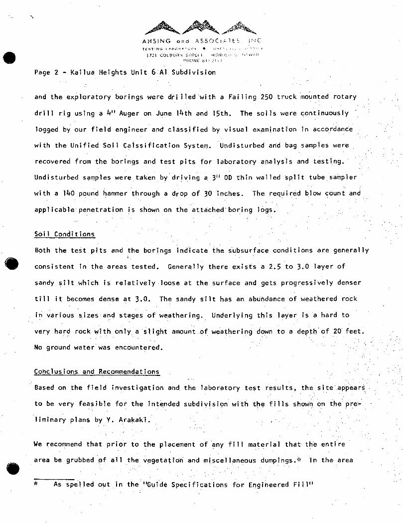
Page 2- Kailua Heights Unit 6:AJ Subdivision
and the ex~loratory borings were dti lled·with a 'ailing 250 truck ~ounted rotary
dri11 rig using a 4" Auger on June 14th and 15th. The soils were continuously ·
logged by our field engineer and classified by visual examination in accordante
with the Unified Soil Ca1ssification System. Undisturbed a~d bag samples were . .
recovered from the borings and test pits for laboratory analysis and testing.·
Undisturbed samples were taken by driving a 311 00 thin walled split tube sampler . . . .
with a 140 pound ~ammer through a drop of 30 inches. The required blow count and
applicable penet.ration is shown on the attached·boring Jogs.
Soil Conditions
Both the test pits and the borings indicate ihe iubsurface conditions are generally ··.
consistent in the areas tested. Generally there exists a 2.5 to 3.0 layer of
sandy silt which is relatively loose at the surface and gets progressively denser
till it becomes dense at 3.0. The sandy silt has an abundance of weathered rock
i~ various sizes a~d stages of weathering. Underlying this layer is a hard to
very har? rock with only a slight amount of weathering down to a depth' of 20 feet.
No ground water was encountered.
Conclusions and. Recommendations
Based on the field investigation and the laboratory test results, the site·.a~p~ar~ ··
to be very feasible for the intended subdivision with the fills showQ on thepre,.. ·
liminary plans by Y. Arakaki.
We recommend that prior to the placement of any fi 11 material that the entire
area be grubbed of all the vegetatiori and miscellaneous dumpings.* ln the area
* As spelled out in the 11Gt.!ide Specifications for Engineered Fi11 11
..... '\.
e
-
·::, .
. ~.;.' ._.
:: •..
~~~ AHSING and ASSOCIAlF:S. it-JC 1E!:-TI:-.,jt_~! a&;~r .. 4.'JO~:~· • :;.;:;.~;t t.! .. •. ~·. 11v_;·~!..
l72J C.:OLfHJRI"' S!r(f[l t1Ut.Jt)I_.:.J;._i.) HA\VAii PHONE ii·• ;· .J: 1 J
Page 3- Kailua Heights Unit 6 Al Subdivision
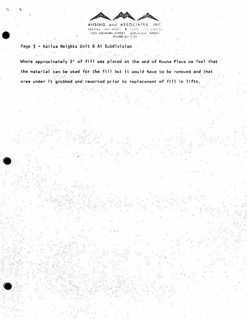
Where :approximately 2 1 of fi 11 was placed at the end of Kuuna Place we feel that
the matetial can be used forth~ fill but it would have to be rem6ved and that
area under 1t g~~~b~d and reworked prior to replacement of fill in lifts.
j.
. ....

-
e
-
~~ ~. -1ft·, .. j;"'· ..... ll•ftli"·~·~ ...... AHSi~JS and ..:. S ;; 0 t: :A 1: '. 1 r~ !.-
1 t ;-. T! r-. .-; !. ,. :.;- · ;F "·-: ~-,'"" · •
11~:1 (i)L!-1-':.n~r~ ~;~;~;:_~; !·~-.lf~·d···:; i;.":.:;r"·.'
~'!!l}~~f. ~.s..:/;;~-.
APPENDIX I
GUIDE SPECIFICATIONS FOR ENGINEERED FILL
General. The designation 11 Engineered Fi"ll'' is applied to a fill placed
under the direct superVision of a Soils ~ngineer for the purpose of supporting
buildin~ foundations or other loads. The Soils Engineer shall approve the materi~l~
th~ method of placing ~nd compacting, and shall give written approval of th~
completed fi 11. No deviation from these specificatio~s ~hall be made excep~ upon
the written approval of th~ Soils Engineer~
Clearing and Grubbihg; ·All timber logs, trees brush, buried rubbish, of. . . .
decayed matter, and other undesirable material.within the areas ~ffected by the
grading operations, or if ca 11 for on plans,. sha 11 be removed in a satisfactory
manner.
All vegetable matter such as roots, tree stumps, grass, etc., shall be removed
from the surface upon whi~h fill is to be placed. Such surfaces shall be uniformly
scarified .to a depth of at least six (6) inches and the operatiOn shall be contin~ ; . '
ued unti I all objection~ble matter is disposed of and the sci 1 is free of s·ame as
well as large tlods. · It sh~ll then be brought to the propet moisture content~
additional fill soil being added if necessary, and recompacted until the density
meets the requirements as hereafter specified.
· When f i 11 s or embankments are .to be ina de and compacted on hi 11 sides, or
when new fi 11 is to be compacted against existing fi 11, or whe.re fi 11 is to be . . . . .
built part width at a time, the slopes of the original hillside, Old or new fill,
shall b~ cut into or benched as th~ work is brought ~p in lay~rs, Material thu~
cut out shal.l be recompacted along with the material brought up. No 'soil

e !
-~,-'. ~~~ AH.SING and A SSOC lA ·1 E S. IN C. T E ~. ·;··~ f\: G LA e: 0'"' AT 0 I; ·,· • IN ::l P f C 1 , (I~·· ::;. t. h' :.• ';,.; f
1721 COLBl)HN STR[O HONC'I.IJLLl. H•l;'iAll ~·wr~£ 64/-21 :n
Page 2 - Append~x
containing o~ectionable vegetable matter of the kind mentioned shall be used in
fJlls supporting housing units, but shall be disposed of as directed by the S6ils
Engineer, in special waste areas.
Compaction Requirements. All fill areas and embankments shall be built up
in uniform layers~ The loose thickness of each layer shall be adjusted so that
the. required ~egree of compaction, as hereafter specified, can be readily attained,
but shall not in any even~ e~ceed approxim~tely ~ix (6) inches compacted thickness.
Eac~ layer shall be thoroughly compatted before the next layer i~ laid thereon.
The compaction op,erations shal_l be carried out using approved c'oinpacting
equipment, stich as sheepsfoot tampers, fl-at-wh~el iollers~ pneumatic roller~, or
e combinations thereof as directed by the Soils Engineer.
In general, all fi 11 cqm·paction operations shall be carried out and the layers
of soil compacted at a moisture content which is optimum for the soil, the optimum
moisture content being determined by ASTM 01557 .• If the moisture content of the
soil is below optimum, enough water shall be added to the soil. to bring its moisture . . .
content up to optimum. If above, the soil shall be allowed to dry, aerating by,
blading, harrowing, etc., to speed up the drying, until the moisture content drops
down to approximately optimum.
Compaction of each and every layer of fill shall be continued until the density, . .
I· . as determined by field tests reaches a value of at least 90% of the maximum indicated
by ASTM 01557.
Fills on Hillsides and Slopes. Where fills are made on hillsides or slopes,
e the slope of .the original ground upon_which the fill is to be placed shall be

••
•
•
~~~'-AHS!NG ond ASSO(IA."!ES 11'-!C. 1 L £ T t N ·:i L A fJ U FA i 0 R 'f 0 i ~. ~ ·'I" :_ I , ~.) •·1 ;, t. '< >' , •.'. I.
i"J:~-i ~:OLCH.ti·fN S~R.(t.! H·.r·._;(JI.'.'I.il.· ;;;...•,·;J.I;
Ptit::-J.l ;;4/-:•n:~
Page 3 - Appendix I
plowed or scarified deeply or wher~ the slope ratio of the original ground is
steeper than 5 horizontal to 1 vertic~l, the bank shall be Step~ed or benched.
Ground slopes which are flatter than 5:1 shall be benched when considered necessary
by the Soils Engineer.
Roc~y Material. When fill material includes rock, no large rocks will be
allowed· to nest and all voids must be carefully filled with s~nall stones or
earth and properly compacted. No large rocks will be permitted higher than
twenty-four inches (24'') bel~w the fi ~ i shed grade.
Drainage. Care shall be exertised during the rdugh grading work so that
areas involved will drain prop~rly. Thus, as far as practicable, all ruts and
depressions resulting from construction traffic shall be carefully smoothed
out at the end of the day's ~ork. All fill slopes ·shall be protected by temporary
terms.
Field Tests.· Th~Soil~ Engineer shall be notified in advanc~ as to the date
grading operations ·are s~heduled to start, .so that he may make the necessary
preparations for carrying out field density tests to determine the actual relative
compa~tlons be obtained, and thus-determine appropriate corrective measures, if·
needed.
Field density tests shall be made by the Soils Engineer of the compaction
of each layer. of fill. Density tests may be made at entervals not exceeding 2 feet
of fi 11 height provided all layers are tested. Where sheepsfoot rollers are
used the soil may be disturbed to a depth of several. inches. Density reading
shall be taken in the comp13ct~d mat~dai below the disturbed surface, and as
often as necessary, as determined by the Soils Engineer~ Whe_n these readings

(-
I
. . . .
..
e:
•
···~~~ AHSING and ASSOCIAlES, INC. .TE.ST.IN~ 1:-.ABO~~TORV e tN$PEC.Tl:··N ~£fiVICE.
172l COLBURN STREET HONOLIJl U. H:1WAII
FHtlNe. B4U:l::J3
Page 4 - Appendix 1- .. •,
indicate that the density of any" 1 ayer of f i 11 or portion thereof iS be 1 OW the •'
required density, the particular ,layer or"portion shall 'be reworked until the
required density has been obtained~·
Supervision. Supervision by the Soils Engineer shall be made during the
fill and compe~cting operation so that he can certify that the fill ·was made ·in
accordance with ac~epted ~pecifications.
GUIDE SPECLFICATIONS FOR USE nF OVERSIZ~ MATERtAL .'
Oversize material. Occasi.onal rock particles up to 12 inches in diameter
(or largest dimensions) may be u~e~ in th~ fil 1 layers provided they· are spaced . . . .· . . .
at least 3 diameters apart.·· Rock particles larger than 12 inches in diameter shall
be scalped out and wasted in designated areas. Oversize material, when placed
in fills, shall be surrounded by, and suffitient earth or other fine material sh•ll
be placed around the large particles as they are deposited so as to fill the
interstices and produce a dense compact fill. No over$ize material shall b~. . .
placed higher. than2 feet below finish grade •.
~: .
.. .·.··

-,.... .u Cll Q)
~ -...c .u p. QJ
0
~ ~ ,)A;-tl; M_.'WA.It • MAlsl
~ t ~. ' ~ ;j ~ " B : A • • ,4..,. ,_ 't 0 I,.. !lo • ( ; T · 0 ftrlo !!it ( "' \r · "- l
I '2: C:Q,.ijL'"" s:~[[l tiCINOlUL;J H .• W411
P..,C!\1£ 847·2133
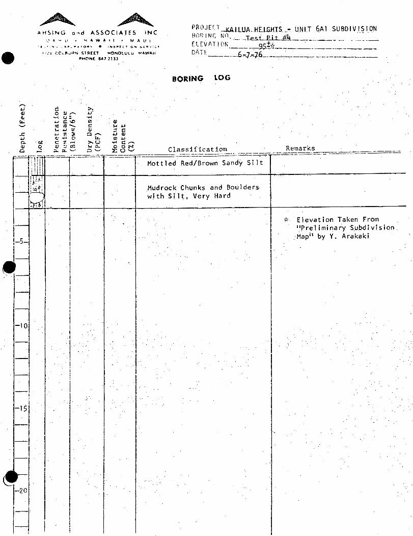
PRCJFCT --M1LUA. HEIGHTS - UNIT 6A I SUBDIVISION
~~'~\~,~~I ~~~-~:~~-JL~.i~:•_ -.... _·_·_· _· -~--~- .. ~~--~----~~ D /\H. __ .-6.= 1.6.-:. .6_ . -. --~---------· ----·------
. .. . 1 -:-·--------·--·------------. --
A H S l !'< G o " d .4. 5 5 0 C I A. T E 5 . I N C .
BORING l.OG
,. >. 5 ill ......... .u ~ (.; : ..... .u c..o UJ QJ
·- ltl- c '"' .u ~ .u u: Q.l ::! c ..., tf; ~ o..-.. .u Qi w..., 0 u.. l'f).U
!IC ..... :r;....., >.CJ "rl c.-.. 0 CJ ... a: l-oP.. OON
,_J p.. .X: ....... 0 '-' ::r::L''-' Classification Remarks ~:.-==+~~:.:::=::..=:-::t=:=-....:...-=::--===--::::.::..:.:.==--==---==-=·- --·-:-::-_ . .-.: -:::-==-~-----~-::~ .::~·::::=_-:::::~:--7::'. =..:.-::--=-.=.:=.==:::;.:.:.:.=
.\ :• 14 i ~ 30 I 51.99 I;; 33 ~) i 50/1 11
~~ i. I ; I,
50/2''
I ;. I.· . ! . . i
1 50/1~1 , i .. ·l ... I . I
I 0/3"
6.86 Brown Sandy S i1 t (ML). with Weathered Mudrock, Dry, Loose
Brown Weathered Rock
LL =· 39.05; PI 18.56
..
No Water Encountered. * Elevation Taken From
"Preliminary Subdivision Map" by Y. Arakaki

~ ~ r>~:n.Jtrr ___ ~A-1--lU.lL.!:I.ELGHT.S - .. UNIT 6Al SUBDIVISION
~~~~ ~~ ~~n. --·-- --#2-+-----------~....--.,;.-----··· .. - -- -~--. _ .• . I lN_..:.2 ____ no.:.t;: . DI'·TE ~ ·-----,..,,----.----------
----6.--1.0=76------ --- --·-- ----------
AH51NG and ASSOCIATES. !NC.
0 o " •.' .. .tl W P. I I • M .tl U I
e· • • "' •· · .._.... , 6 .. ·." li:t ... ,. () ~ 'II • I N ~ .... t l 1' I 0.. 5o I • \f ~ ( f
: '."1 COll!uR•• STRtfl .,ONOlUlU >io\W.tlll
P"'OIII[ 847-2133
BORING LOG
,...... 4-J c >-GJ c ~,....... 4-J Cli ~ t.•-.... - .....
ea. ~c:...o al C!J ........ r,ct- c: '-'4-J '1-. ..... !IJ QJ ::i c: ...r:: ~ en 3 Cl- 4-J QJ
4-J CJ ..... c ea. til ._j 0. oc c: ~~ ...... >-U ~ c:-GJ C· ~ CJ a:) ,1-. c.. 0 OiN! Classification Remarks 0 ,_;j c...xv c- ~u...._., -.1-=:;;-----=-·.:.:.::;.::I_------- - -+--- . , ____ ·.:=~ ·_ =-=.:=-:..:-.:.:.-::.::::..:.:._-==---r-=:-==-==--=--=--===;:-:~-.... ==.=-===·
l~ll 92.24 13.70
1~ 1 ~~- Loose_ Brown Sandy S i.l t (ML) · ~
1 18 · with Weathered Mud rock, Dry, I . _
l---1 ! ; · Lq Loose. LL :;::: 38.9; PI = 18.49 ! l I 50/311 113.09 11 . 05
1--
, __ -5-:-t' --4-...:t.::f..!.._l_']
.~-- I !' -- ,____ I I
[ I I
-I
I
-JO
I
I I l
I
-·I -I
I
--··I i
-I
~I -201
~
I I I i I i
I I ! .1. I I. I .. . . i ,. . i
I I ! !
Mottled Red/Gray Rock Slightly Weather~d. Hard. · · Greenish Gray Highly Weathered Mudrock ·
Mottled Orange/Gtay Mudrock I Slightly Weathered & Hard.
1
I
. BOH tw 13.0
No'Water Encouhtered:
* Elevation ·Tak~n From . 11Prel iminary Subdivision. Ma.p" by Y. Arakaki.

e.
-4oJ G) G)
;:... ........
~ ~ A HS'ING o.,d ASSOCIATES. INC
0•-~; HAWAII • ""ALII
• I ":· 1' ..,. ·• .. • ._ ·." 10 ~ T (J. 1o • 1 N !t IJ.o f •: T l l"'l.... ~·IE lit~: I a,;. (
: 1~1 CCt BIJ<lP>i S tR£(T !"!O"'OtUL U. HAWAII PHONE 841·] l.H
::: :>, 0 cu ,-.. .LJ. ~c.;: ~
.wt:..O Ul G) nlt'tl- c 1-J~ ~ ~ ~ G) ~ :::
.J:: .;..JU):J o- ~Gl ~ <;;-0 tz.. Ul~ a. on :: m.-< >.u ~c . ..-.. (I) 0 \j) Q)c;Q 1-JO.... 0 CiiN:
t:: ·...:; t:.-0::'-" 0'-' ~U'-'
PROJEC1~8J1UA HEIGHTS -UNIT 6Ai SUBDIVISION BORING 'No: ·T;-tPit iff···-····-·-.······· ____ , ______ _ ELEVATION----~':' -----.. -·--·-
DA H 6:~:1:.]..!!!.6'--___ _:.__
BORING l.OG ,. . '
. '
Classificat ipn Remark!?. ~-=l----::.=~f=='---·- ____ =f _____ _
l 11::, l I I Mottled Brown Silt with ! f6,; Weathered Mudrock
Ll = 36~20; PI = )8.88@ 3.0
LL :;:: 38.21; Pl.= 1.9.69 (loose material from Excavation
Signs of AC & Concrete·.·. dumoed at Site
. i if -i ll··
93.65 23.95 I . \~i I
i Hard Mudrock I . .
t ;
I I I ' . I I r- !
I 5 . I I ,-- ! i
el-, I ~-·
_ .. _, . I I .. '
~--
l~lo ,_ : i ,-1 I-I I ,
l-1 ! I l-l5l l l 1-1 I I i 1 _,
i .--1
At I ~~--
1 1-20 I i . I ,_, ' I i-1
! . l
.!
I I
I
j I
I I I
I I . ·l I
·I j
i I
I
··I . ·k . E 1 evat ion "fa ken From · "Pre 1 i ni ina ry S u bd i vision
Map'' by Y. Arakaki
. .-.. ·,. .·.
.·

e
,..... ~ QJ QJ ~ ........
.r: .u 0. Q:
Q
~ ~ AHSING ond ASSOCIATES. INC.
('.A>1tl • "AWAII • MAUl ·f·.f!ll.•;. <-•1';:-"'Af'C" ........ IN!.Pf("1t(') ... ,..(.\'1((
11:1 co; f'Ouo>N ST!l£[l "O~OlUlY "AWAII
P"'0Nl 847-:?133
PROJfCT KAILUA HEIGHTS- UNIT 6Al SUBDIVISION f3l)R INC. NO~ -- T~~t-Plt -#2·· . . . . . ...... - ---·- . -[L EVAT I ON ___ :=_-:-..=·- !flp;-------·---···· .. ···---~-0/\ 1 i:: 6.=j.::]_6 . . ·------
----- ----. - ·-. ..-------·:--·--------~------·
BORING lOG
c:: >. 0 QJ,-... .u
....... u:. -i-1 .,_; C:::\0 t~ Q)
"' c:l-- c:: ~ u ,.. ..... II) QJ ;j c:: ..., Ul ;:. o..-.. .u QJ '-f'rl c c... g)~
Classification Remarks ---------·-= .·.:-...:..:=.-=--=.=.,::--===.:::--=:..=.:. ==-====--·-=---=-=--==--=------·----oc t: ~~ >.U ~ r;:,-... 0 Q: a:• ~ ~c:l. 0 ON ' P...::X:'-'" 0 ....... :l:· u ......... -;:.x:...:=--..:.::.=:.::.::.::=~~ . !
Gravelly
Gray We~thered Mudrock, Ver~ Hard
LL = 30.50; PI = 12.24
I
! ! I I I I· ! .I
I ' I j
12 Sample@ 3.5 ·
* ~levation Taken From· 11 Preliminary Subdivision Map" by Y. Arakaki

-,-... ~ Ill cu
fa. -.c . ...., 0. Ql
Q
~ ~ At-iSING and ASSOCIATES, INC.
OAHU • HAWAII • MAUl T(STihQ LA80111AfCUn· • lf'of6P'£CTt0N &~aYIC~
PROJECT~TS : . .JJ~.!l§~-~~BD~ION BORING NO.~est Pit #3 .. ELEVATION 100'±;': .
1721 COL_BURN STREET HONOLULU. HAWAII. P'HO .. E 147-2133 .
DATE 6-7~~
BORING LOG
(: >. oa~,-... LJ
·'1"'1 ·tJ: ....; ..... ~"' II) cu Cllt'CI- ~ ~....,
.... ...., tn Cll ::J s: ...., m ) o- LJ cu Cii ....t 0 fa.. m.u
ClG C::Cil-M >.U '!"'IC::-0 (1) Ql_p:l I-4P.. OON ..J p.,~- Q- X:U"-' Classification Remarks
· Matt 1 ed Brqwn/(iray C 1 ayey S i 1 t
. Weathered Mudrock Mixed with. Sandy Silt.
:,.
* · Elevation Taken From 11 Pre]iminary Subdivision Map 11 by Y~ Arakaki
~ ~ PROJUT-¥.AILUA.HtiG..HIS -UNIT 6Al SUBDIVISION HOnING tHJ. . T · n: .. ~-,, . . . . . ·-- ..
·-····- ..e.s.L . ..c:...L.J.....=t. _______ .. ___ - -··· - ....... ----
~--~-~~fi.T I ON _____ -,---95.!~~~-. ___ · ·-·-------,----· ·-'·------·.6.,.~7--,_Jfi _____ .-. --,-,-.----·---------------
AH51NG ond ASSOCIATES INC
e ... ~ A .... \1 • "1 4 ~ A I I • "" A l.l I
·t·.• ...... 4fl_ O•tO., • 1,_..5-P((T.C!'If tt[tr:· .. ::.•
I ::a CC't!'•J»'-i SlR[.[T ><ONOtULU ><t.WAII I>HC'N( 8.&7 ~133
BORING lOG
- . .J C: >. Q) 0 ill- ~: a; -;u: . ...-l
tL .... c. \0 ia Q) '-' ~ ctl- ::: J.< ~
~ ~ ~ ~ = ::: ..c: .;...,(!:;): o..-. ~QI <OJ e,.o..,;..o tz.. m.u 0.. ·at c 7....-i >.0 ...-l :::..-.. Q) o o; :: I:Q ~ :::... .o o N Cl . f. . R k
~~---=--~__::- ':"~--~-':'-~~~------a-~~l __ _lC~~_!-~~r~=--=::===-----z_-:.:~~r-~----=-==-.:.:...-:-::-:-:=:-=-.:...=~= . ~~~\! -~---- -·- ·--Mottled--R~d/Brown Sa;dy Sil.t
! l I 1
-- 11~~, I .
i:q~ '
1
. I Mudrock Chunks and Boulders ~-
1 with Silt, Very Hard
~d
I J-5-
-10
I I
I
I
~· I
I
I i I j
I< I i '
. l· I
...
* Elevation Taken From ''Preliminary Subdivision.
·Map11 by Y. Arakaki

e:
-..... Cll (II
J,s... .._,
..r:: .u 0.. (l)
0
-20
-1 ' I
~ ~ AHS1~G ond A550(1AlfS. INC.
0 4 !-4 v "' A ., II I I M 'I U f
1 f ~- • ..... .# : A p .. 'II A ., 0 lit 'f • I .... P ( ( 1' I 0... S. (." I.;: (
;>;, ,~':'llhiP ... 51A[£T H0fll0lUU) H'IV.AII
c c :lJ,.....
. .,..., u: ..... C\D q) q)-L. ~ {I)
.u !/'. ~ 0..'-:-' 0
oc :::: IJl ~ .. c ~ u;a:::
...... c..~'-"' ·-·--·-
t>lo<Qf\1£ a.7-2133
;:... ~ ~
til ~ <:1 o-·c.. >.U ~p..
0 ........
<il .... .u :l c ..... (l!
lb.u "1-lC,..... CON ::O:U'-"
FRhj[(i ___ .K/H L!)A HEIGHTS - UNIT 6A 1 SUBDIVISION SCWINt; NO. . T~~t--P-lt--1/S .. · .. r:• •t . ' -------·-+;-------·-·-·-·----~-. L ._ [\,. ,1 tuN .§3__;.-:,
Dl\ T L ----~=-- _ G-_J::.l~- ~~~~=~---:~==~~~-=~~-----= _ BORING lOG
Classification Remarks . -. ··- - ---~_:.:_.,-·. ·..:.....::.::::=:::.=.:::..-'- '---~==: :.=:="~=---=:-:"-~-· -·--:=--..:-=.--=
Very Hard Mud rock Could not Exc~vate. · (Broke Tooth on BackHoe}
I I I i I
I
I I f
I I· I
--:~
l
I.
Elevation Takeri From "Preliminary Subdivision Map" by. Y. Arakaki
!..;

11'1'MYt1 'rltiVP ~O&!nY-10d/l ''vn11'1.>1 J.Y
I-=-V!J J..l tin 9.lti91-al1 Vn11 V>l
~/ !t· ~ ....... rtt ~·~ ~ '
p~ 'J'J
~I Ql
Oll
~1
81
"n·
+'II
~ ~II )...: ___ j
~II
£,11
Ill
------·---------. "i
7\. j!i
s::: t:
.X::
~ Ui
r.. ~
~ ~· I~
\!\ O!i -\
~ ~
~ ~ t\l <.
""' m ~
"""""
-I.. 6V
L'ir .
)..~ 'V'ti I )I
I .