© 2009 pearson prentice hall this work is protected by united states copyright laws and is provided...
TRANSCRIPT

© 2009 Pearson Prentice Hall
This work is protected by United States copyright laws and is provided solely for the use of instructors in teaching their courses and assessing student learning. Dissemination or sale of any part of this work (including on the World Wide Web) will destroy the integrity of the work and is not permitted. The work and materials from it should never be made available to students except by instructors using the accompanying text in their classes. All recipients of this work are expected to abide by these restrictions and to honor the intended pedagogical purposes and the needs of other instructors who rely on these materials.
Lecture Outlines PowerPoint
Chapter 5
Earth Science, 12e
Tarbuck/Lutgens

Earth Science, Earth Science, 12e12e
Running Water and Running Water and GroundwaterGroundwater
Chapter 5Chapter 5

Earth as a system: the Earth as a system: the hydrologic cycle hydrologic cycle
Illustrates the circulation of Earth’s water supply
Processes involved in the cycle• Precipitation• Evaporation• Infiltration• Runoff• Transpiration

The hydrologic cycleThe hydrologic cycle
Figure 5.3

Sources of Earth’s waterSources of Earth’s water
Figure 5.2

Running water Running water
Drainage basin• Land area that contributes water to a river
system• A divide separates drainage basins

Drainage basins and Drainage basins and drainage dividesdrainage divides
Figure 5.4

Running water Running water
Streamflow • Factors that determine velocity
• Gradient, or slope • Channel characteristics
• Shape• Size• Roughness
• Discharge – volume of water flowing in the stream (generally expressed as cubic feet per second)

Running water Running water
Upstream-downstream changes • Profile
• Cross-sectional view of a stream • From head (source) to mouth
• Profile is a smooth curve • Gradient decreases from the head to the mouth
• Factors that increase downstream • Velocity• Discharge
Running water Running water
Upstream-downstream changes • Profile
• Factors that increase downstream • Channel size
• Factors that decrease downstream• Gradient, or slope • Channel roughness

Longitudinal profile Longitudinal profile of a streamof a stream
Figure 5.7

Running water Running water
The work of streams • Erosion• Transportation
• Transported material is called the stream’s load• Dissolved load • Suspended load• Bed load

Running water Running water
The work of streams • Transportation
• Load is related to a stream’s • Competence – maximum particle size• Capacity – maximum load
• Capacity is related to discharge

Running water Running water
The work of streams • Transportation
• Deposition• Caused by a decrease in velocity• Competence is reduced • Sediment begins to drop out
• Stream sediments • Known as alluvium• Well-sorted deposits

Running water Running water
The work of streams • Transportation
• Features produced by deposition • Deltas – exist in ocean or lakes• Natural levees – Form parallel to the stream
channel • Area behind the levees may contain
backswamps or yazoo tributaries

Formation of natural levees Formation of natural levees by repeated floodingby repeated flooding
Figure 5.21

Running water Running water
Base level • Lowest point to which a stream can erode • Two general types
• Ultimate – sea level• Temporary, or local
• Changing causes readjustment of the stream – deposition or erosion

Adjustment of base level Adjustment of base level to changing conditionsto changing conditions
Figure 5.15

Running water Running water
Stream valleys • Valley sides are shaped by
• Weathering • Overland flow• Mass wasting
• Characteristics of narrow valleys • V-shaped• Downcutting toward base level

Running water Running water
Stream valleys • Characteristics of narrow valleys
• Features often include • Rapids• Waterfalls
• Characteristics of wide valleys • Stream is near base level
• Downward erosion is less dominant • Stream energy is directed from side to side
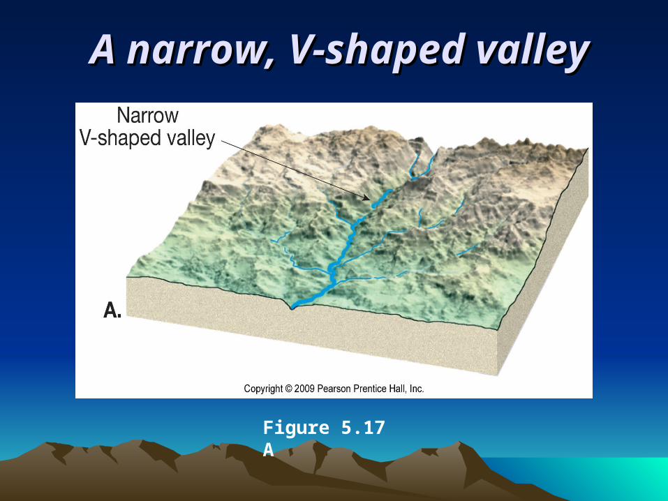
A narrow, V-shaped valleyA narrow, V-shaped valley
Figure 5.17 A

Continued erosion and Continued erosion and deposition widens the valleydeposition widens the valley
Figure 5.17 B

A wide stream valley is A wide stream valley is characterized by meandering on characterized by meandering on
a well-developed floodplaina well-developed floodplain
Figure 5.17 C
Running water Running water
Stream valleys • Characteristics of wide valleys
• Floodplain • Features often include
• Meanders• Cutoffs• Oxbow lakes
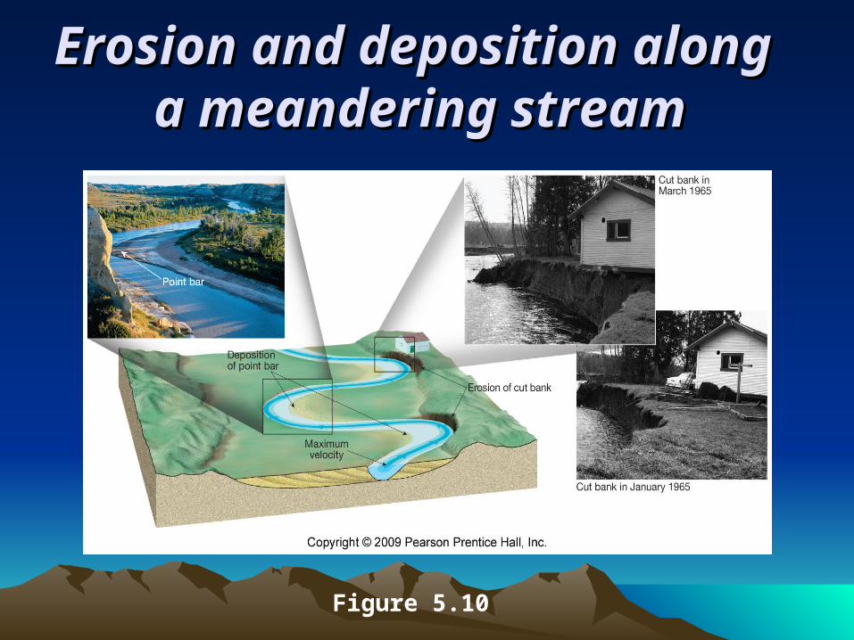
Erosion and deposition along Erosion and deposition along a meandering streama meandering stream
Figure 5.10

A meander loop on the A meander loop on the Colorado River Colorado River
Figure 5.18

Formation of Formation of a cutoff and a cutoff and oxbow lakeoxbow lake
Figure 5.11

Running water Running water
Drainage patterns• Networks of streams that form distinctive
patterns• Types of drainage patterns
• Dendritic• Radial• Rectangular• Trellis

Drainage patternsDrainage patterns
Figure 5.22

Running water Running water
Floods and flood control • Floods are the most common geologic hazard • Causes of floods
• Weather• Human interference with the stream system
Running water Running water
Floods and flood control • Engineering efforts
• Artificial levees• Flood-control dams• Channelization
• Nonstructural approach through sound floodplain management
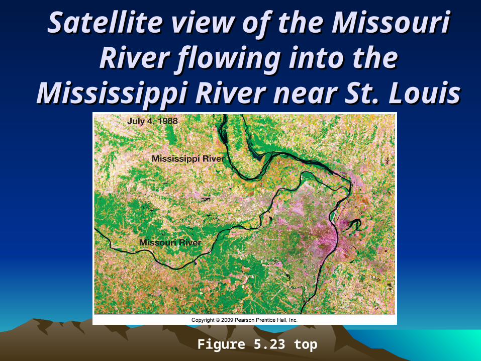
Satellite view of the Missouri Satellite view of the Missouri River flowing into the River flowing into the
Mississippi River near St. LouisMississippi River near St. Louis
Figure 5.23 top
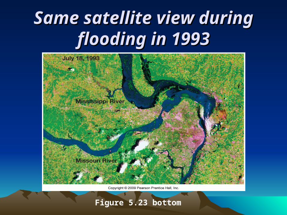
Same satellite view during Same satellite view during flooding in 1993flooding in 1993
Figure 5.23 bottom

Water beneath the Water beneath the surface (groundwater) surface (groundwater)
Largest freshwater reservoir for humans Geological roles
• As an erosional agent, dissolving by groundwater produces
• Sinkholes• Caverns
• An equalizer of streamflow

Water beneath the Water beneath the surface (groundwater) surface (groundwater)
Distribution and movement of groundwater • Distribution of groundwater
• Belt of soil moisture • Zone of aeration
• Unsaturated zone • Pore spaces in the material are filled mainly
with air

Water beneath the Water beneath the surface (groundwater) surface (groundwater)
Distribution and movement of groundwater • Distribution of groundwater
• Zone of saturation • All pore spaces in the material are filled with
water • Water within the pores is groundwater
• Water table – the upper limit of the zone of saturation

Features associated with Features associated with subsurface watersubsurface water
Figure 5.26

Water beneath the Water beneath the surface (groundwater) surface (groundwater)
Distribution and movement of groundwater • Distribution of groundwater
• Porosity • Percentage of pore spaces • Determines storage of groundwater
• Permeability• Ability to transmit water through connected
pore spaces • Aquitard – an impermeable layer of material • Aquifer – a permeable layer of material
Water beneath the Water beneath the surface (groundwater) surface (groundwater)
Features associated with groundwater• Springs
• Hot springs • Water is 6–9°C warmer than the mean air
temperature of the locality • Heated by cooling of igneous rock
• Geysers • Intermittent hot springs • Water turns to steam and erupts

Old Faithful geyser in Old Faithful geyser in Yellowstone National ParkYellowstone National Park
Figure 5.29

Water beneath the Water beneath the surface (groundwater) surface (groundwater)
Features associated with groundwater• Wells
• Pumping can cause a drawdown (lowering) of the water table
• Pumping can form a cone of depression in the water table
• Artesian wells• Water in the well rises higher than the initial
groundwater level

Formation of a cone of Formation of a cone of depression in the water tabledepression in the water table
Figure 5.31

Artesian systemsArtesian systems
Figure 5.32

Water beneath the Water beneath the surface (groundwater) surface (groundwater)
Environmental problems associated with groundwater • Treating it as a nonrenewable resource • Land subsidence caused by its withdrawal • Contamination

Water beneath the Water beneath the surface (groundwater) surface (groundwater)
Geologic work of groundwater • Groundwater is often mildly acidic
• Contains weak carbonic acid • Dissolves calcite in limestone
• Caverns • Formed by dissolving rock beneath Earth’s
surface • Formed in the zone of saturation
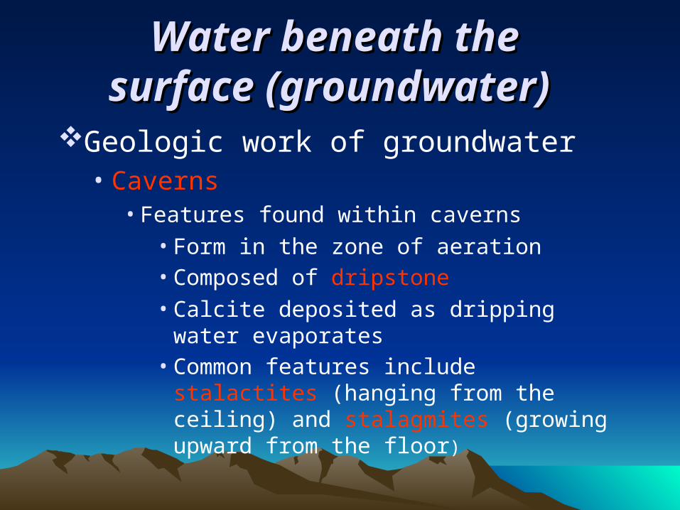
Water beneath the Water beneath the surface (groundwater) surface (groundwater)
Geologic work of groundwater • Caverns
• Features found within caverns • Form in the zone of aeration • Composed of dripstone
• Calcite deposited as dripping water evaporates
• Common features include stalactites (hanging from the ceiling) and stalagmites (growing upward from the floor)

Cave Features in Lehman Caves, Great Cave Features in Lehman Caves, Great Basin National Park, and Carlsbad Basin National Park, and Carlsbad
Caverns National ParkCaverns National Park
Figure 5.38

Water beneath the Water beneath the surface (groundwater) surface (groundwater)
Geologic work of groundwater • Karst topography
• Formed by dissolving rock at, or near, Earth’s surface
• Common features • Sinkholes – surface depressions• Sinkholes form by dissolving bedrock and
cavern collapse• Caves and caverns
• Area lacks good surface drainage

Features of karst Features of karst topographytopography
Figure 5.39 C

End of Chapter 5End of Chapter 5